T
T
H
H
E
E
`
`
S
S
E
E
En vue de l’obtention du
DOCTORAT DE L’UNIVERSITE
´
DE TOULOUSE
D´elivr´e par : l’Universit´e Toulouse 3 Paul Sabatier (UT3 Paul Sabatier)
Pr´esent´ee et soutenue le 13/11/2013 par :
Alan HALLY
Pr´evisibilit´e des ´episodes m´editerran´eens de pr´ecipitations intenses:
Propagation des incertitudes li´ees aux param´etrisations de la
microphysique des nuages et de la turbulence
JURY
Sylvain Coquillat Pr´esident du Jury
Silvio Davolio Rapporteur
Christian Barthlott Rapporteur
Victor Homar Ve´ronique Ducrocq
Examinateur Directrice de th`ese
Evelyne Richard Directrice de th`ese
E´ cole doctorale et sp´ecialit´e :
SDU2E : Oc´ean, Atmosph`ere et Surfaces Continentales Unit´e de Recherche :
Laboratoire d’A´erologie (UMR 5560) Directeur(s) de Th`ese :
Evelyne Richard et V´eronique Ducrocq Rapporteurs :
iii
Remerciements
Tout d’abord je tiens à remercier mes deux directrices de thèse, Evelyne Richard et Véronique Ducrocq. Je vous remercie beaucoup de m’avoir soutenu et guidé pendant mon travail de recherche, et d’avoir été patientes avec mes fautes de français !
J’aimerais aussi remercier Juan Escobar et Didier Gazen, les guerrièrs de Méso- NH. Vous étiez toujours disponible pour répondre à mes nombreuses questions avec patience et gentillesse.
Un grand merci à Soline Bielli de m’avoir aidé avec les complexités de NCL et aussi de m’avoir supporté dans son bureau. Merci également a Michael Faivre et Philipp Scheffknecht qui ont pris la suite de Soline.
Je remercie Frank Roux et tous les gens du Laboratoire d’Aérologie qui m’ont ac- cueilli si chaleureusement.
Merci beaucoup aux membres du jury d’avoir accepté de se plonger dans mon manuscrit.
Pour dire un dernier mot, mais surtout pas le moindre, je tiens à remercier les doctorants de l’Observatoire Midi-Pyrénées et surtout ceux du LA. Ce n’est jamais facile de quitter chez soi pour un autre pays, mais vous l’avez rendu beaucoup plus facile avec vos propositions de sortie, votre aide pour trouver du logement et votre humour. Vous êtes tous les bienvenu(e)s en Irlande quand vous le voulez !
Acknowledgements
The first and most important thank you goes to my family and especially to my parents. The possibility to come to Toulouse and undertake this work wouldn’t have been pos- sible without your continuous support and encouragement. A special thank you also to my Nana and grand-uncle, two people who gave me a love of learning that has gotten me to where I am today.
A huge thank you to all my friends in Toulouse, Ireland, Australia or wherever you may be!
Finally, I would like to thank Peter Lynch, Ray Bates, Rodrigo Caballero and all the other great lecturers at University College Dublin who instilled in me a passion for the world of meteorology.
Contents
Introduction en français 1
Introduction 5
1 Physical parameterisations and ensemble forecasting 9
1.1 Microphysical parameterisations . . . 9
1.1.1 Particle distributions and one and two-moment schemes . . . 10
1.1.2 Hydrometeor characteristics . . . 13
1.1.3 Warm process parameterisations . . . 13
1.1.4 Cold process parameterisations . . . 16
1.1.5 Key processes in rainfall production . . . 17
1.1.6 Formulations used in convection-permitting NWP . . . 18
1.1.7 ICE3 formulation . . . 19
1.1.8 Summary of microphysical parameterisations . . . 21
1.2 Turbulence parameterisations . . . 21
1.2.1 Summary of turbulence parameterisations . . . 25
1.3 Ensemble forecasting . . . 26
1.3.1 Definition of terms and ensemble scores . . . 26
1.3.2 Ensemble strategies . . . 27
1.3.3 Short-range ensembles and number of members . . . 29
1.3.4 Summary of ensemble forecasting . . . 30
1.4 Thesis objectives . . . 31
2 Idealised simulations and testing of ensemble strategy 33 2.1 Methodology . . . . . . 33
2.1.1 Méso-NH . . . . . . 33
2.1.2 Adjustable microphysical parameters . . . 35
2.1.3 Microphysical time tendencies . . . . . . 37
2.1.4 TKE and turbulent time tendencies . . . 39
2.2 Isolated storm description and Méso-NH set-up . . . 39
2.3 Domain 1 . . . . . . 40
2.3.1 Particle distribution . . . . . . 43
2.3.2 Intercept parameter . . . . . . 44
2.3.3 Autoconversion cloud content and time constants . . . 46
2.3.4 Hydrometeor classes . . . . . . 46
2.3.5 Microphysical processes . . . . . . 46 v
vi CONTENTS
2.3.6 Turbulent tendencies . . . . 49
2.3.7 TKE and TKE sources . . . 55
2.3.8 Conclusions - Domain 1 . . . 55
2.4 Domain 2 . . . . . . 55
2.4.1 Intercept parameter . . . . 56
2.4.2 Microphysical processes . . . 58
2.4.3 Turbulent tendencies . . . . 60
2.4.4 Testing ensemble size . . . 62
2.4.5 Conclusions - Domain 2 . . . 62
2.5 Idealised squall line description and simulation set-up . . . 63
2.5.1 Microphysical and turbulent processes . . . . . . . 65
2.5.2 Conclusions - idealised squall line simulations . . . 67
3 Real case studies 69 3.1 Presentation of article . . . 69
3.2 Ensemble simulations with perturbed physical parameterisations . . . . 70
3.3 Cold process perturbations for a real world situation . . . . . . 88
4 HyMeX convective lines 91 4.1 Presentation of article . . . 91
4.2 An ensemble study of HyMeX IOP6 and IOP7a . . . 92
4.3 Other factors in rainfall development . . . 113
4.3.1 Initial and boundary conditions . . . 113
4.3.2 Atmospheric and surface conditions . . . 130
4.3.3 Conclusions - Other factors in rainfall development . . . 137
Conclusions and perspectives 139
Conclusions et perspectives 143
A List of important symbols 147
Introduction en français
Les événements fortement précipitants sont des phénomènes naturels extrêmes qui se retrouvent dans toutes les régions du Monde. Leurs effets peuvent être dévasta- teurs : des crues soudaines et des glissements de terrain provoquent la perte de vies humaines et animales ainsi que l’interruption de l’activité économique. En se focal- isant par exemple sur la seule année 2013, on compte déjà de nombreux événements catastrophiques. Suite à une activité cyclonique persistante en janvier 2013, l’est de l’Australie a souffert de crues étendues qui ont conduit à des dégâts d’une valeur de presque 2 milliards d’euros. Une dépression stationnaire, flanquée de deux centres anti-cycloniques, a provoqué de fortes précipitations sur les pays d’Europe centrale entre mai et juin 2013. Les crues qui en ont résulté ont été la source de dommages sig- nificatifs dans plusieurs pays tels que l’Autriche, l’Allemagne et la République tchèque. Le coût total de cet événement a été de l’ordre de 12 milliards d’euros.
Pendant les mois de septembre à novembre, la région de la Méditerranée nord- occidentale est exposée à un type d’événement fortement précipitant qui, en raison des reliefs avoisinants, est très spécifique à la région. En automne, la mer Méditer- ranée reste assez chaude par rapport aux terres qui l’entourent. Quand les vents de sud passent au-dessus de cette mer chaude, de l’humidité est collectée et transportée par l’écoulement de basses couches qui, contraint par le relief, va converger en direc- tion du littoral. Ce flux chargé d’humidité est ensuite forcé à s’élever dans l’atmosphère, soit par la convergence dans les bases couches, soit par la présence d’une plage d’air froid ou soit encore par l’orographie, déclenchant ainsi de la convection susceptible de mener à des événements très violents et dont les conséquences sont largement am- plifiées par la rapidité de la réponse hydrologique. Ces événements peuvent avoir des effets catastrophiques pour les populations locales. En automne 1987, dans le sud-est de l’Espagne, 800 mm de pluie sont tombés en moins de 24 h près de la ville de Gandia et y ont provoqué d’énormes dégâts (Fernandez et al. (1995)). La région du Piedmont en Italie a connu un événement particulièrement sévère en novembre 1994 quand 300 mm de pluie tombés en moins de 36 h ont conduit à une soixantaine de victimes et des dégâts d’une valeur de 12 milliards d’euros (Buzzi et al. (1998)). En 1999, une crue éclair faisant suite à de fortes précipitations dans le département de l’Aude dans le sud-est de la France a entraîné la mort d’au moins 23 personnes (Ducrocq et al. (2002)). En 2002, 700 mm de pluie sont tombés en 24 h sur le département du Gard dans le sud de la France. Cet épisode a causé 20 victimes et des dommages d’un milliard d’euros (Nuissier et al. (2008)).
La fiabilité et la précision des prévisions météorologiques de ces événements sont 1
2 INTRODUCTION d’un intérêt majeur pour l’anticipation des mesures de protection civile. Ceci a conduit la communauté scientifique à mettre en place divers projets de recherche ayant pour but d’améliorer notre compréhension du développement et de l’évolution de ces événe- ments et d’en améliorer la prévision. MEDEX (MEDiterranean EXperiment), DRIHM (Distributed Research Infrastructure for Hydro-Meteorology) et HyMeX (HYdrological cycle in Mediterranean EXperiment) sont trois exemples de tels projets. MEDEX avait pour objectif d’examiner plus en détail la prévision des dépressions méditerranéennes et des événements extrêmes qui leur sont associés, ainsi que d’en étudier les im- pacts sociétaux. DRIHM, un projet lancé récemment et bénéficiant d’un financement de l’Union européenne, vise à améliorer la collaboration entre météorologues, hydro- logues et experts en technologies de l’information et de la communication afin de con- duire à de meilleures prévisions hydro-météorologiques pendant les épisodes de fortes pluies. HyMeX est un projet international de recherche qui vise à une meilleure com- préhension du cycle de l’eau en Méditerranée. HyMeX a réalisé sa première campagne d’obervations intensives (Special Observing Period, SOP1) de septembre à novembre 2012. L’amélioration de la prévision des événements fortement précipitants en Méditer- ranée nord-occidentale était au coeur des objectifs la SOP1 d’HyMeX.
Un point important pour l’amélioration de la prévision d’événements fortement pré- cipitants réside dans l’amélioration de la prévision de la convection profonde. Dans les modèles globaux, les processus convectifs sont paramétrés. La résolution hori- zontale de ces modèles ne permet pas de résoudre explicitement les interactions com- plexes et multi-échelles prenant place au sein des systèmes nuageux à fort développe- ment vertical. Ces dernières années, avec l’augmentation de la puissance de calcul, les modèles régionaux sont devenus capables de fonctionner à l’échelle kilométrique, ce qui leur permet de résoudre explicitement les processus de la convection. Selon leur résolution spatiale, ces modèles sont désignés par Convection-Permitting Models ou Convection-Resolving Models. Cependant, malgré ces progrès, la précision de la prévision numérique de ces événements reste limitée. Cela est dû en grande partie à la nature de l’atmosphère qui est fondamentalement chaotique. Cette caractéristique limite la précision des prévisions numériques déterministes. En particulier, dans la prévision de la convection profonde, les erreurs et les incertitudes liées aux processus de petite échelle peuvent s’accroître rapidement, ce qui diminue la capacité du modèle à prévoir correctement l’évolution d’un événement météorologique. Ceci a conduit au développement de stratégies de prévision probabiliste dont le but est de prendre en compte les erreurs et les incertitudes inhérentes à l’état initial de l’atmosphère et aux paramétrisations du modèle. Plutôt que de produire une seule prévision déterministe, les systèmes de prévision d’ensemble produisent un éventail de prévisions, ou mem- bres, qui ont des représentations des conditions initiales, conditions aux limites et pro- cessus physiques légèrement différentes entre elles. Ceci permet le développement d’une vision probabiliste de l’évolution de l’atmosphère et la description des erreurs liées aux incertitudes dans la formulation du modèle.
Deux sources d’incertitudes sont devenues de plus en plus importantes avec l’accroissement de la résolution des modèles, la représentation des processus de la physique des
3
nuages sont explicitement résolus, les processus de la microphysique contrôlent le développement des nuages et des précipitations dans le modèle, ce qui les lie directe- ment aux processus de la convection et à l’évolution des systèmes convectifs. Les processus de turbulence de la couche limite sont également d’une grande importance pour une meilleure représentation de la convection humide. Une augmentation de la résolution permet une description explicite partielle de la turbulence, mais les tourbil- lons de petite échelle restent non-résolus et donc paramétrés. Comme ces paramétri- sations utilisent nécessairement des hypothèses et simplifications, elles introduisent des erreurs dans le système de prévision. Pour décrire ces incertitudes, des perturba- tions des paramétrisations de chaque processus peuvent être introduites. L’utilisation d’un grand nombre de perturbations permet ainsi de construire un système de prévi- sion d’ensemble et donc de prendre en compte l’erreur des paramétrisations.
L’objectif de ce travail est d’évaluer l’importance de ces incertitudes et leur impact sur la distribution des précipitations simulées par un modèle de prévision à l’échelle kilométrique et pour des échelles de temps d’une courte durée. Le Chapitre 1 intro- duit les différentes méthodes par lesquelles les processus de la microphysique et la turbulence sont paramétrés en soulignant les zones d’incertitudes potentielles. Une introduction au domaine de la prévision d’ensemble est également fournie avec des exemples de plusieurs études ayant mis en oeuvre des systèmes de prévision prob- abiliste. Le Chapitre 2 décrit le modèle utilisé dans ce travail ainsi que la méthodolo- gie adoptée pour construire une prévision d’ensemble fondée sur la perturbation des paramétrisations de la microphysique et de la turbulence. Cette méthodologie est util- isée pour étudier une super-cellule et une ligne de grain idéalisées. Inspirées par les résultats du chapitre 2, des simulations d’ensemble avec physique perturbée, effec- tuées pour une série de cas réels récents, sont décrites au chapitre 3. Le chapitre 4 est consacré à deux situations de lignes convectives observées pendant la SOP1 de HyMeX. La sensibilité des précipitations aux incertitudes de la physiques y est évaluée et comparée à celle induite par les incertitudes des conditions initiales et aux limites du modèle. Le manuscrit se termine avec les conclusions et perspectives du travail réalisé pendant cette thèse.
Introduction
Heavy precipitation events (HPEs) are an extreme weather phenomenon frequently occurring in many parts of the world. The effects of such phenomena can be devas- tating: flash-flooding, landslides, loss of human and animal life, disruption of economic activity. Using solely the year 2013 as an example, numerous catastrophic events have occurred. In the aftermath of persistent cyclonic activity in January 2013, Eastern Aus- tralia suffered extensive flooding which led to almost e2 billion worth of damage. A stationary low-pressure system, flanked to the west and the east by blocking highs, brought persistent and heavy rainfall to Central Europe in May and June 2013. The resulting floods caused significant damage in many countries, including Austria, Ger- many and the Czech Republic. Total costs of this heavy rain event were reported to have been close to e16 billion.
Between the months of September and November, the Mediterranean region is af- fected by a type of HPE which, due to the complex geography of the surrounding area, is unique to this region. In the autumn months, the Mediterranean sea remains quite warm compared to the land basins which surround it. As southerly winds pass over this warmer sea, moisture is picked up and advected along with the flow, which is forced to converge on the south-eastern coastlines by the surrounding orography. This moisture laden-flow is then forced to rise into the atmosphere (either by low-level convergence, a low-level cold pool or by local orography) triggering convection which can lead to some very active and dangerous precipitation events. These Mediterranean HPEs can have devastating effects on the local economy. In autumn 1987, in south-eastern Spain, 800mm of rain fell in less than 24 h near the city of Gandia which led to enormous damage in the local community (Fernandez et al. (1995)). The Piedmont region of Italy also suffered a catastrophic heavy rain event in November 1994, when 300mm of rain in less than 36 h resulted in the deaths of 60 people and e12 billion worth of dam- age (Buzzi et al. (1998)). In 1999, flash-flooding after a HPE in the Aude department in southern France caused the death of at least 23 people (Ducrocq et al. (2002)). In 2002, 700mm of rain fell in 24 h over the Gard department in southern France resulting in the deaths of at least 20 people and e1 billion in damages (Nuissier et al. (2008)).
Accurate forecasts of these events are thus of the utmost importance, which has led to the establishment of numerous international research projects aiming to im- prove the understanding of their development and evolution. MEDEX (MEDiterranean EXperiment), DRIHM (Distributed Research Infrastructure for Hydro-Meteorology) and HyMeX (HYdrological cycle in Mediterranean EXperiment) are three examples of such projects. MEDEX concentrated on the forecasting of Mediterranean cyclones and on
6 INTRODUCTION
the extreme weather events associated to them while also investigating the societal impacts of such phenomena. DRIHM is a recently launched EU funded project which aims to improve the collaboration between meteorologists, hydrologists and information and communication technology experts and thus lead to better hydrological forecasts for HPEs. HyMeX is an international research project which seeks to better understand and forecast the water cycle in the Mediterranean. It undertook its first Special Observ- ing Period (SOP1) in September 2012. At the core of SOP1 is a desire to improve the forecasting of HPEs which, especially between the months of September to November, can greatly affect the water cycle in the Mediterranean region.
A key issue in the improvement of the forecasting of HPEs is an improvement in the forecasting of moist convection. In climate and global models, the convective pro- cesses are parameterised by different schemes as these models run at a horizontal resolution which is not capable of explicitly resolving the complex interactions which take place during convection initiation. In recent years, with the advance of comput- ing power, regional models have been capable of performing simulations at kilometric scale resolutions, thus leading to nearly explicit resolution of the convective processes. Depending on the resolution, these models are referred to as Convection-Permitting Models or Convection-Resolving Models. However, despite these research efforts and advances in numerical weather prediction, the skill with which HPEs can be forecast remains limited. This is due in large part to the fundamental chaotic nature of the at- mosphere which places a limit on the accuracy of deterministic numerical forecasts. In particular, when forecasting deep convection, errors and uncertainties related to small-scale processes can grow quickly, disrupting the ability of a model to accurately forecast the development of a future weather event. This has led to the development of a probabilistic forecasting strategy, which aims to represent the errors and uncer- tainties which are inherent in the initial atmospheric state and in the formulation of the numerical model. Instead of producing a single deterministic forecast for an event, en- semble prediction systems (EPSs) produce a number of forecasts, or members, which have slightly different representations of the initial conditions, boundary conditions and physical processes. This allows a probabilistic picture of the evolution of the atmo- sphere to be developed and the errors related to model formulation uncertainties to be represented.
Two sources of uncertainty, which have become increasingly important with in- creased model resolution, are the representation of the microphysical cloud processes and the processes of boundary layer turbulence. At cloud-resolving scales, micro- physical processes control the development of cloud and rainfall within the model, link- ing them directly to the processes of convection, the evolution of a convective system and the localisation of the rainfall pattern. The boundary layer turbulence processes are also of great importance to the improved representation of moist convection. In- creasing the resolution leads to the explicit representation of some of the turbulent properties but, the small-scale turbulent eddies remain unresolved, and thus remain parameterised. As these parameterisations use assumptions and simplifications when describing these processes, errors in their representation are introduced into the fore- casting system. In order to represent these uncertainties, perturbations can be
per-7
formed upon the process parameterisations. Using numerous perturbations allows an EPS to be constructed and thus permits the parameterisation error to be represented.
The importance of these uncertainties and their impact upon the rainfall field sim- ulated by a forecasting model at the kilometric scale and at short-range time-scales are the focus of this study. Chapter 1 introduces the different methods by which the microphysical and turbulence processes are parameterised, highlighting areas of po- tential uncertainty. An introduction to the domain of ensemble forecasting is given with examples of previous studies which successfully implemented probabilistic fore- casting systems. Chapter 2 describes the research model used throughout this study, the ensemble forecasting methodology applied to an idealised supercell and idealised squall line set-up and the method employed to perturb the uncertainties associated to the microphysical and turbulence processes. Inspired by the results of the idealised simulations in Chapter 2, ensemble simulations with perturbed physical parameterisa- tions are performed for real world cases in Chapter 3. The sensitivity of the rainfall field of two convective systems observed during the HyMeX SOP1 to physical param- eterisation uncertainties is presented in Chapter 4. A comparison between the level of sensitivity to physical parameterisation uncertainties and that of initial and bound- ary condition uncertainties is also described in Chapter 4. The manuscript ends with conclusions and perspectives of the work undertaken during this thesis.
Chapter 1
Physical parameterisations and
ensemble forecasting
1.1 Microphysical parameterisations
Clouds play a vital role in the drama that unfolds in our skies on a daily basis. They exert a strong influence on the short-wave and long-wave radiative transfer, they act as a stage upon which water vapour converts itself to precipitation and they are a very important part of heat transfer within the atmosphere, due to their release of latent heat. Because of this importance, it is of the utmost interest to represent accurately the various processes operating within clouds in order to properly forecast the state of the atmosphere. It is not yet possible however, due to the extreme complexity of the mechanisms involved, to model them explicitly, thus assumptions and simplifications in the form of parameterisations have to be made. These parameterisations come in two forms; bin models and bulk models. Bin models look to explicitly calculate the evolution of the particle size distribution by segregating the particles into differ- ent bins. These bins are defined according to different particles sizes and thus many bins are needed to describe cloud condensation nuclei, cloud droplets and raindrops, not to mention the large number of bins needed to explicitly define the different ice hy- drometeors. There are many examples of such models including Feingold and Grund (1994), Harrington et al. (1999) and Jiang et al. (2000). Despite being more physically accurate in their description of the different particle distributions, bin models are rarely implemented in numerical weather prediction models due to the enormous computa- tional cost that would be involved in doing so. To find a balance between cost and an accurate physical description of the atmosphere, one resorts to bulk models, which represent the hydrometeor sizes according to a distribution function, allowing for com- putationally less expensive simulations. For this reason, this state of the art will focus solely on bulk model representations.
10 CHAPTER 1. PHYSICAL PARAMETERISATIONS AND ENSEMBLE FORECASTING
1.1.1 Particle distributions and one and two-moment schemes
Bulk models usually describe a number of different classes of hydrometeor, and as- sume a distribution function for each class of particle, with raindrops, cloud droplets, graupel, ice, snow and sometimes hail being described. This idea of a distribution function began with the pioneering work of Marshall and Palmer (1948) (MP). They as- sumed that the raindrop particles were distributed according to the generalised form,
n(D) = N g(D) (1.1)
with n(D) being the number of drops as a function of the drop diameter D, N be- ing the total drop number concentration and g(D) being a normalised distribution law. Observations led them to propose the following form for g(D),
g(D) = λ exp(−λD) (1.2)
with λ being the slope parameter.
Passarelli (1978) later applied the MP distribution to snow flakes within an analytical model leading to “fair agreement“ between theoretical and observed values of snowfall rate. Ziegler (1985) later extended the use of the inverse exponential function to rep- resent his hail/graupel category following the work of Houze et al. (1979). This same author also showed however that the MP distribution can be unrealistic at small diam- eters below which the observed distribution deviates from the MP distribution. This led several authors to choose a generalised gamma function when defining the raindrop distribution law (Williams and Wojtowicz (1982), Willis (1984) and Ziegler (1985)),
α g(D) =
Γ(ν) λ
αν Dαν−1 exp(−(λ D)α) (1.3)
This distribution has two additional parameters and offers more flexibility than the MP distribution. Fig. 1.1 shows the different distributions possible with different values of the shape parameter ν. This parameter controls the relative amount of smaller vs. larger hydrometeors in the distribution. α, the scale parameter, controls the spread in the distribution, the larger its value, the more the distribution would spread to the right in Fig. 1.1. It can be noted that when α and ν both equal 1, the gamma dis- tribution degenerates into the MP distribution. In principle, the gamma distribution allows a better match to observed distributions. However, suitable observations are not always available and often α and ν are arbitrarily prescribed. Meyers et al. (1997) and Milbrandt and Yau (2005) demonstrated that the value of α can affect the peak in accumulated surface precipitation as well as impacting upon the sedimentation and microphysical source/sink terms.
Bulk models are usually cast into two categories. If only the time evolution of the mixing ratio (or water content) of each particle type is predicted, the scheme is re- ferred to as a one-moment scheme. These schemes differ from two-moment schemes, which additionally predict the time evolution of the number concentration of the parti- cle type. In the absence of a prognosed concentration (one-moment scheme), further assumptions have to be made in order to define the distributions. The total number
1.1. MICROPHYSICAL PARAMETERISATIONS 11
−4
0g
concentration, N , is in this case either kept constant, or more commonly, related to the slope parameter (λ) through a power relationship,
N = N0 λx (1.4)
ls where x and N0 are constants which depend upon the particle class. For rain-
drops, classically x=-1, and in the case of the MP distribution, N0 represents the inter-
cept parameter of the distribution. Both N0 and x have to be prescribed for each parti-
cle type. Large discrepancies can exist in the values of these constants depending on the author and/or data-sets used. For instance, Waldvogel (1974) proposed a range for N0r , or the raindrop intercept parameter, of between 0.4 107m and 3.5 107m−4.
Knight et al. (1982) proposed a range for N0g , the graupel intercept parameter, of be-
tween 104m−4 and 108m−4. More recently, Gilmore et al. (2004) showed the impact
of changing the value of N0g upon supercell characteristics by using a range of
val-ues stretching between 4 102m−4 and 4 108m−4. He showed that values of N from
the upper end of this spectrum gave less accumulated precipitation at the ground. Solomon et al. (2009) reported values for N0s, the snow intercept parameter, of be-
tween 2 105m−4 and 6 105m−4 which contrasts with the value of 2 107m−4 used in Dudhia
(1989).
To summarise, in single-moment schemes, up to four parameters must be pre- scribed to fully describe the size distribution of each particle type. Given the wide range of their observed values (especially for the ice category), they present obvious sources of uncertainty.
Prognosing the time evolution of the number concentration of each particle type decreases the level of uncertainty but adds to the computational cost. Reisner et al. (1998) carried out simulations to underline the differences in using a one-moment and a two-moment scheme. Their one-moment scheme prescribed the mixing ratios for the water and ice species, while the two-moment scheme included prescribed rela- tionships for the number concentrations of ice, snow and graupel. The results show a significant increase in agreement with observations when the two-moment scheme is implemented for a study of the supercooled liquid water for two winter storms which occurred over the Rocky Mountains in 1990. Thompson et al. (2004) also rigorously tested this scheme, examining the flow over an idealised two-dimensional mountain. They suggested several improvements to the scheme including introducing a snow intercept parameter which depended on temperature and a rain intercept parame- ter which was related to the rain mixing ratio. Seifert and Beheng (2006) described a slightly different two-moment scheme. Mass density and number concentration of five hydrometeor classes were prescribed including a full treatment of cloud droplet number concentration. This parameterisation was designed especially for use in high- resolution mesoscale models and, unlike the schemes of Reisner et al. (1998) and Thompson et al. (2004), allowed the effects of cloud condensation nuclei upon cloud formation to be evaluated. Morrison et al. (2005) presented a further double-moment parameterisation which differed slightly from the schemes previously introduced. The number concentration and mixing ratio of the specified hydrometeor species again serve as prognosis variables with new physically based parameterisations for
simulat-12 CHAPTER 1. PHYSICAL PARAMETERISATIONS AND ENSEMBLE FORECASTING
Figure 1.1: Taken from Walko et al. (1995), this figure illustrates a set of gamma distribution curves for integer values of ν from 1 to 10, with α held fixed at 1. The values of g(D) are given in function of the hydrometeor diameter. The curve labelled MP in red represents the Marshall- Palmer distribution with ν and α equal to one. The peaks of the curves shift progressively to the right as ν increases.
ing homogeneous and heterogeneous ice nucleation outlined. Morrison et al. (2005) described two versions of the scheme, one to be implemented at high-resolutions and a second more suitable to coarser resolution models where supersaturation cannot be resolved.
Overall, two-moment schemes tend to give more accurate representations of the time evolution of the different drop species. However, the higher computational cost of these schemes means that their implementation in an operational forecasting system is rare and they are more often reserved for research activities.
1.1. MICROPHYSICAL PARAMETERISATIONS 13
ρ
c
1.1.2 Hydrometeor characteristics
The mass and fall speeds of each particle type are also user-defined within most bulk models. The most common method for defining these parameters is to follow the ob- servational work of Locatelli and Hobbs (1974), who measured the fall speeds and masses of a large number of different precipitating particles. Fig. 1.2 illustrates the variety of solid particles which were noted during this observational work. Two key re- lationships were used to classify the hydrometeors; one related the mass of the particle to its diameter,
M = a Db (1.5)
and the other related the fall speed of the particle to its diameter,
V = c Dd (1.6)
where the constants a,b,c and d describe the different characteristics of the precipi- tating particles, of which Locatelli and Hobbs (1974) measured 6 graupel and 8 snow categories. Foote and Toit (1969) and Liu and Orville (1969) described terminal veloc- ities and mass-diameter distributions for raindrops, while Heymsfield and Musil (1982) and later Starr and Cox (1985) offered representations of the ice particle velocities and mass-diameter distributions. Sensitivity to the ice particle representation is shown by the work of Ferrier (1994). Two different sets of fall speed coefficients are used to per- form simulations of an intense squall line over southeastern Virginia. Their results show that the precipitation distribution and fallout were affected by modifying the ice particle characteristics. Gilmore et al. (2004) reported on the sensitivity of ground precipita- tion to modifications in the graupel/hail density properties, thus in turn manipulating the mass and fall speeds. He demonstrated that the heavier (lighter) particles had the tendency to remain at higher altitudes (to fall faster) thus decreasing (increasing) the precipitation volume which reached the ground.
1.1.3 Warm process parameterisations
Parameterisation of the microphysical processes dates back to the late 60’s and the fa- mous work of Kessler (1969). In this monograph, where only warm-rain clouds were in- vestigated, he observed that the liquid water species can be broken into cloud droplets and raindrops. The cloud water within his formulations comes from condensation, and consists of small droplets with negligible velocity. Cloud water can be converted into rain when the cloud water content (given as qcrit in equation 1.7) reaches a value of be-
tween 0.5 to 1gm−3. The raindrops can simultaneously grow by the accretion of cloud water droplets, or can evaporate below the cloud level. Kessler proposed formulae to describe these processes. His autoconversion process, or the conversion of cloud wa- ter (represented by mixing ratio rc) into rain water, was parameterised by the following
relationship,
CAU T R = k (r − qcrit
dref
14 CHAPTER 1. PHYSICAL PARAMETERISATIONS AND ENSEMBLE FORECASTING
·--.:!
...
'---'..
.
p
...
,
,
,r:'
J'L' ':t' tl"r "-'r
s
t
(
•
($1
...
, ,
.... .,
v
Figure 1.2: From Locatelli and Hobbs (1974). This image displays the different types of solid precipitation partie/es on which measurements were made. The sca/ed line below each photo- graph represents 1mm
1.1. MICROPHYSICAL PARAMETERISATIONS 15
where k is a time constant and ρdref the air density. By this formulation, the autocon-
version rate increases linearly with the cloud water mixing ratio. He also described suitably appropriate formulae for the accretion of raindrops and the evaporation of rain- fall in terms of N0 of the MP distribution, a capture efficiency E, the cloud content
and the precipitation content. Klemp and Wilhelmson (1978), amongst others, used Kessler’s formulations to simulate a three-dimensional convective storm. His formula- tions proved very effective in representing the warm microphysical processes, and are currently an option in many numerical forecasting models.
Despite the success of his parameterisations, due in large part to their simplicity and thus low computational cost, other warm-rain parameterisations have also been successful.
Berry and Reinhardt (1974a) and Berry and Reinhardt (1974b) proposed a slightly different approach to that of Kessler with their autoconversion parameterisations based upon results of the stochastic coalescence equations. The accretion and rain evapo- ration processes were also formulated in a slightly modified manner, with the accretion process being parameterised as a function of the collection kernal, while an extra term was added to the rain evaporation parameterisation in order to take into account the number of drops which disappear completely by evaporation per time step. A more complete comparison of the differences between the two parameterisations can be found in Richard and Chaumerliac (1989).
Pruppacher and Klett (1978) also reported upon warm cloud microphysical pro- cesses. They proposed a formula for calculating the evaporation of a raindrop of diam-eter D, dD [ dt ]evap = 4 S f¯ ρlω A (1.8)
where S and A are defined as the following, rvs − rv S = rvs , (1.9) A = Rv T es(T )Dv + Lv (T ) ( kaT 2 Lv (T ) Rv T − 1) (1.10) "' Rv T es(T )Dv Lv (T ) + kaRv T 2 . (1.11)
and where rvs is the saturated vapor mixing ratio, Dv is the diffusivity of water vapor
in air and ka is the heat conductivity of air. All other terms are defined in Appendix
A. This formulation involves a ventilation coefficient, f¯, which in turn depends on the Reynolds number of the flow around the water drop. Comparisons of experimentally determined ventilation coefficients for water drops and a parameterisation of the co- efficient is discussed within Pruppacher and Klett (1978). It is shown that at certain equivalent drop radii, the observed coefficient can differ from the theoretically derived version. A comparison of the observed and derived coefficient is shown in Fig. 1.3. This gives a degree of uncertainty to the definition of the process, and shows that no matter how mathematically correct a formulation, simplifications and assumptions must be made compared to the complex reality of the process.
16 CHAPTER 1. PHYSICAL PARAMETERISATIONS AND ENSEMBLE FORECASTING
Figure 1.3: From Pruppacher and Klett (1978). Displayed is a comparison of experimentally determined ventilation coefficients for water drops of large Reynolds numbers with an extrapo- lation of the theoretically computed ventilation coefficient for water drops at moderate Reynolds numbers.
The evolution of the representation of the warm microphysical processes shows a tendency towards increasingly complex and realistic parameterisations. However, due in large part to the sparse collection of observational data, these parameterisations remain somewhat deficient in describing the exact nature of the warm microphysical processes.
1.1.4 Cold process parameterisations
The cold cloud microphysical processes also play a very important part in the inter- actions between the different water species. Thus representing them accurately is important for our understanding of atmospheric convection. One of the earliest bulk parameterisation schemes for the cold processes was proposed by Lin et al. (1983). They defined six different water species (water vapour, cloud water, cloud ice, rain, snow and graupel) and five classes of hydrometeor (cloud water, cloud ice, rain, snow and hail) in order to simulate a moderate intensity thunderstorm for the High Plains region. They used a single-moment scheme, as only the mixing ratio of the differ- ent particles was used as a prognosis variable. The graupel and snow particles were distributed according to an inverse exponential distribution following MP. With this pa- rameterisation they succeeded in realistically simulating the transformation of cloud ice to snow and onto hail. They also showed that the presence of the snow variable within their parameterisation reduced the amount of rainfall forming early in the life history of the cloud. Finally, they illustrated that, at least for their case study, the hail/graupel
1.1. MICROPHYSICAL PARAMETERISATIONS 17
melting was the main source of rainwater, even when the process of autoconversion of cloud drops into raindrops was active.
More recently, Straka and Mansell (2005) formulated a single-moment microphysi- cal scheme with 10 ice categories characterised by their habit, size and density (two ice crystal habits, rimed cloud ice, snow, three categories of graupel, frozen drops, small hail and large hail). They claimed that this large number of hydrometeor classes allowed a variety of convective storms to be simulated with minimal parameter tuning. All of the precipitating particles were distributed following the MP inverse exponential law. One of the advantages of this scheme is that it uses what they call a riming his- tory to calculate the transitions between the graupel and frozen drop categories, which provides smoother transitions in particle density and fall speed. Having multiple cate- gories of ice defined adds realism to their simulations, and it is shown to be especially useful for the simulation of electrification and lightning.
The two schemes of Lin et al. (1983) and Straka and Mansell (2005) clearly show differences in their representation of the cold process parameterisations. Making com- parisons between these two schemes, it is evident that there exists uncertainty as to the most appropriate approach for formulating the parameterisations. The definition of the different water species, the number of water species to employ and the method used to describe their distributions being just a few important differences. This incertitude demonstrates that, as for the warm processes, no one scheme can claim superiority over another when it comes to the representation of the processes.
1.1.5 Key processes in rainfall production
While all the cold and warm microphysical processes have some impact upon rain- fall production, there are certain processes which will have a greater degree of im- portance. For warm clouds, the autoconversion process is the sole rainwater initi- ation mechanism, thus it plays an important role, especially in determining the first occurrence of rain within the model. Secondly, the evaporation of raindrops will also be quite important. Bresson et al. (2009) and Nuissier et al. (2008) amongst others have shown that the convective cold pool which develops below certain HPEs plays a role in sustaining convection while it can also lead to the formation of new convective cells. These convective pools are mainly alimented by the evaporation of raindrops below the cloud base. As the raindrops pass through the non-saturated layers below the cloud, evaporation takes place due to a release of latent heat. This leads to an area of cooler air forming beneath the cloud which constitutes the convective cold pool (Miglietta and Rotunno (2009), Miglietta and Rotunno (2010)). Thirdly, the melting of graupel or snow particles while falling through the atmosphere will also significantly impact upon the rainfall output (Ducrocq et al. (2008)).
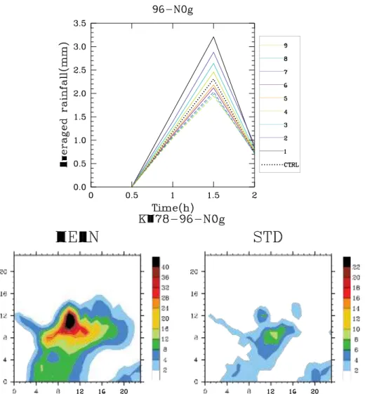
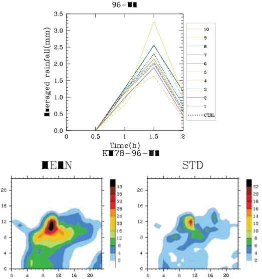
The study of Lascaux et al. (2006), in which numerical simulations were carried out upon 3 cases of heavy precipitation in the Alps, illustrated the relative contribution of certain processes to the rainfall output. The three episodes which were investigated represented an intense and moderately convective system, as well as a case of strat- iform precipitation. As demonstrated in Fig. 1.4, the main normalised sources for the
18 CHAPTER 1. PHYSICAL PARAMETERISATIONS AND ENSEMBLE FORECASTING
Figure 1.4: Mean vertical structure of the main microphysical processes involved in IOP 2A of the Mesoscale Alpine Programme (MAP) (from Lascaux et al. (2006)); normalized sources acting on (a) the solid precipitation (snow, graupel. hail) and on (b) the liquid precipitation (rain). (c, d) and (e, f) are as (a, b), but for IOPs 3 and 8, respectively. The short-hand names for each process are taken from Fig. 1.6.
liquid precipitation for each of the three cases were the melting of graupels, the ac- cretion of cloud droplets by raindrops and the evaporation of raindrops. The autocon- version process was shown to be the trigger in the production of raindrops, but it was quickly outpaced by the melting and accretion sources at a height of 2 to 4km and by the evaporation of raindrops at heights of 1km or less. Further examination of Fig. 1.4 demonstrates that the relative importance of each process varied depending upon the nature of the situation.
1.1.6 Formulations used in convection-permitting NWP
Numerical models normally dispose of a range of microphysical parameterisations as, depending on the meteorological situation being studied, the suitability of a certain mi- crophysical scheme will change. The WRF (Weather Research Forecasting) model offers a wide array of schemes, including the basic Kessler scheme (Kessler (1969)) and the breakthrough scheme of Lin et al. (1983). More recent schemes are also avail- able for implementation. Hong et al. (2004) described a 5 class scheme with ice which
1.1. MICROPHYSICAL PARAMETERISATIONS 19 offered a number of modifications over earlier schemes such as Lin et al. (1983). They proposed a temperature dependent intercept parameter for snow, a new formula for di- agnosing the cloud ice number concentration from cloud ice mass, a modified scheme for the autoconversion of cloud water to rain water and the inclusion of the sedimenta- tion of falling ice crystals.
WRF, along with the NCAR/Penn State Mesoscale Model Version 5 (MM5), offers the use of the schemes described in Reisner et al. (1998) and Thompson et al. (2004), which were introduced in section 1.1.1. Thompson et al. (2008), also available as an option in WRF and MM5, is an improved bulk microphysical scheme compared to the latter two. This 6 class scheme has many observational based features including a rain intercept parameter that depends on the rain mixing ratio, a graupel intercept pa- rameter that depends on the graupel mixing ratio and a variable gamma distribution shape parameter for cloud water droplets. Thompson also outlined other new features, notably an improved representation of vapour deposition, sublimation and evaporation along with improved rain-collection of snow and graupel.
The COSMO (Consortium for Small-scale Modelling) model offers a microphysical scheme based on the work of Seifert and Beheng (2001). This is a double-moment parameterisation of the microphysical processes in warm clouds and is directly derived from the stochastic collection equation. The authors described explicit rate equations for autoconversion, accretion and self-collection. An improved version of this scheme, described in Seifert and Beheng (2006) and also introduced in section 1.1.1, presents a revised scheme for the snow intercept parameter which becomes a function of tem- perature and the snow mixing ratio.
The non-hydrostatic model MOLOCH uses a scheme based on the methodology proposed by Drofa (1997), which was inspired in part by the work of Marecal et al. (1993) and Rutledge and Hobbs (1983). The one-moment scheme predicts the time evolution of the specific concentration of four microphysical species: cloud water, cloud ice, precipitating water (rain) and precipitating ice. Recently, upgrades have been per- formed and the scheme is now capable of being implemented as a double-moment parameterisation by integrating in time the spatial distribution of the number density of cloud water and ice which describe the cloud spectra evolution.
1.1.7 ICE3 formulation
This study will concentrate on the mixed-phase microphysical formulation ICE3 which is presented in Pinty and Jabouille (1998) and is used in the operational French model AROME (Seity et al. (2011)). The approach of Pinty and Jabouille (1998) follows that of Lin et al. (1983) closely, in that six water species (vapour, cloud droplets, rain- drops, pristine ice, snow and graupel) are defined. The concentrations of the pre- cipitating water drops and ice crystals are parameterised according to the work of Caniaux et al. (1994). The hydrometeor size-distributions are assumed to follow a gen- eralised gamma-law of the form seen in equation (1.3). The mass-size and velocity-size relationships are defined according to Locatelli and Hobbs (1974).
20 CHAPTER 1. PHYSICAL PARAMETERISATIONS AND ENSEMBLE FORECASTING
πρ N
c
autoconversion of cloud droplets to raindrops, the accretion of cloud water by raindrops and the raindrop evaporation being described. The autoconversion process equation is equivalent to that which was detailed in equation (1.7). The accretion of cloud water by raindrops (CACCR) takes the following form,
CACCR = π 4 aN0( ρ00 ρd ref )αr Γ(b + 3)( ρd ref rr ) lw 0 b+3 4 (1.12)
where a and b are numerical constants, ρd ref is the density at a reference level, ρlw
is the liquid water density. The meaning of all other symbols is given in Appendix A. The raindrop evaporation process is derived from the evaporation rate of a raindrop of diameter D given in equation (1.8). After replacing the factors f¯, S and A by their full expressions and integrating over the raindrop spectrum, one obtains the following equation for the raindrop evaporation source (REV AV ),
2πSNo 1 ρd ref rr 1 ρ00 a b + 5 ρd ref rr b+5 REV AV = A ρd ref r( ) 2 + F ( πρlw No ρd ref )α/2( ν) 1/2Γ( 2 ) ( ) πρlw No 8 1 (1.13)
where S and A retain their definitions given in equations (1.8)-(1.10). All other symbols have been previously defined or are given in Appendix A.
The cold process scheme involves the interaction of many processes (see Fig. 1.5 for process interactions and Fig. 1.6 for explanation of the sources and sinks of the different processes and the nomenclature used to describe each process). The pris- tine ice category is triggered within the scheme by homogeneous or heterogeneous nucleation. These ice crystals grow by the deposition of water vapour, and by the Bergeron-Findeisen effect. Autoconversion of the primary ice crystals initiates the snow phase and growth of these aggregates happens through the deposition of wa- ter vapour, the aggregation of small crystals and riming caused by impacting cloud and rain droplets. Graupel is formed by the continuous heavy riming of snow. As these graupel fall, they melt, becoming raindrops. The equations for all cold process equa- tions can be found in the scientific documentation of the Méso-NH model, available here: http://mesonh.aero.obs-mip.fr/mesonh410/BooksAndGuides.
This scheme was tested on the tropical squall line described in Caniaux et al. (1994). The results show that the overall structure of the squall line was well reproduced by the model. Some limitations of the scheme were noted however as the vertical extent of the system compared to the observed radar reflectivity remained insufficient. It was reported that the evaporation of rainfall below the stratiform region helped to maintain the system, underlining the importance of correctly parameterising this process. As a second test, an area of orographic precipitation between the 12th and 13th of February 1985 over the Sierra Nevada in California was successfully modelled. Comparisons with observations showed that there was good ”quantitative agreement“ between ob- served and simulated values. The model also succeeded in maintaining a supercooled cloud droplet tongue within an area of glaciated cloud. This feature was observed by a field experiment conducted during this particular case and the schemes ability to cor- rectly represent it illustrates that in particular the cold process parameterisations seem to be well formulated.
1.2. TURBULENCE PARAMETERISATIONS 21
Figure 1.5: The different interactions of the microphysical processes of ICE3. The short-hand explanation of each process is given in Pinty and Jabouille (1998). The rx represent the mixing
ratios of the different water species.
1.1.8 Summary of microphysical parameterisations
It has been seen that a large number of microphysical parameterisation schemes ex- ist, whether it be for warm (Berry and Reinhardt (1974a)) or cold (Caniaux et al. (1994)) processes. Schemes can be of one (Lin et al. (1983)) or two-moments (Morrison et al. (2005)), have very few (Kessler (1969)) or very many (Straka and Mansell (2005)) de- fined water species. The schemes can differ by the way in which they define the processes that they parameterise (Kessler (1969), Berry and Reinhardt (1974b)) and in the choice of using MP (Lin et al. (1983)), generalised gamma (Pinty and Jabouille (1998)) or log-normal distributions (Berry and Reinhardt (1974a) and Berry and Reinhardt (1974b)).
All of these differences demonstrate that the best and most realistic way of re- producing the warm and cold cloud microphysical processes is unclear, with certain schemes being preferable according to the computational resources available and the situation being scrutinised. It also shows the large uncertainty there still exists in the world of parameterisation, whether it be a question of particle distribution choice, how best to describe the formation of ice and its progression into snow and eventually grau- pel, or how best to initiate the production of rainfall within a forecasting model. It is clear from this bibliographic synthesis that there is a large degree of sensitivity to these choices, and that depending on the choice made, the evolution and intensity of rainfall episodes forecast by the parent model will be impacted.
1.2 Turbulence parameterisations
Convection, and thus the rainfall of HPEs, are also quite sensitive to the simulation of the turbulent processes. One of the main factors to consider when simulating the turbulent processes is the horizontal resolution at which the simulation is performed.
22 CHAPTER 1. PHYSICAL PARAMETERISATIONS AND ENSEMBLE FORECASTING
Figure 1.6: Taken from Lascaux et al. (2006), this table lists the microphysical processes and corresponding sinks and sources of the ICE3 microphysical scheme and gives the nomencla- ture used to represent each process. In the symbol names, the first letter identifies the sink species (V, C, I, R, S, G, or H for vapour, cloud, pristine ice, rain, snow, graupel, or hail re- spectively), the next three letters give the short name of the microphysical process, and the last letter identifies the source species. An optional letter is added in parenthesis to recall the name of the reactant species in three-component processes. The superscripts (a ,b, etc.) indicate which processes were grouped together for Fig. 1.4, which is also taken from Lascaux et al. (2006).
1.2. TURBULENCE PARAMETERISATIONS 23
Figure 1.7: A schematic explanation of BL89’s mixing length formulation where the bubble, e, represents an air parcel, lup the maximum upward displacement of the parcel and ldown the
maximum downward displacement. The distances are calculated as functions of the virtual potential temperature θv at certain levels z. Appears as Fig.4 in Cuxart et al. (2000).
The choice of horizontal resolution determines the representation of turbulent eddies. Bryan et al. (2003) showed that the details of a simulated squall line can change signif- icantly as resolution is increased, with precipitation amounts, convective cell structure and mesoscale flow patterns all being modified. Weisman et al. (1997) studied squall- lines in mid-latitude type environments and suggested that a 4km horizontal resolution could reproduce the mesoscale structure and evolution of the squall-line with the same detail as 1km resolution simulations but that at 4km the system has a slower evolution due to the delayed strengthening of the convective cold pool. At 1km resolution, more turbulent eddies were explicitly resolved leading to a more correct representation of the mid-latitude squall line.
Unless simulations are performed at a horizontal resolution of a couple of ten’s of metres, some form of turbulent parameterisation is needed. While there has been much progress in these parameterisations in recent years, problems remain. The Navier-Stokes equations present a closure problem when they are integrated in their Reynolds-averaged form due to the presence of non-linear terms. Many methods have been proposed in order to solve this closure issue. Smagorinsky (1963), Deardorff (1980) and Bougeault and Lacarrère (1989) use a method inspired by the mixing length approach of Prandtl (1925) developed in the early 20th century.
Smagorinsky (1963), along with the definition of the mixing length as in Prandtl (1925), proposes formulae for the eddy viscosity in numerical models, derived from the velocity field and the local grid size. The Deardorff (1980) scheme is a 1.5 order scheme which is typically employed at very fine horizontal resolutions where most tur- bulent eddies are explicitly resolved. He uses a sub-grid scale closure method where the mixing length is closely related to the grid spacing.
24 CHAPTER 1. PHYSICAL PARAMETERISATIONS AND ENSEMBLE FORECASTING = e(z), = e(z), (1.14) (1.15) v v v v u θr r 2 2 L h 2 2 4 L 1 ∂θ
Within the French research community, and throughout this study, the scheme of Bougeault and Lacarrère (1989) (BL89) is used extensively. In Bougeault and Lacarrère (1989) (BL89), the mixing length (L) is defined as the distance a parcel of air can move vertically up (lup) or down (ldown) before being stopped by buoyancy effects. Fig. 1.7
gives a schematic view of their mixing length definition which is governed by the follow-ing expressions, z+lup z z g θv ref g (θ (z) − θ (z))dz (θ (z) − θ (z))dz z−ldown θv ref L = (lupldown)1/2
where e(z) is the value of the turbulent kinetic energy at a level z, θv (z) is the virtual
potential temperature at the level z and θv ref is the virtual potential temperature of the
reference state. The definition of the mixing length will affect the coefficients of eddy momentum and heat transfer and thus impact upon the simulation of the turbulent flows, clearly suggesting that the choice of closure method and thus formulation of the mixing length has an impact upon the moist convective processes.
Inspired from the work of Redelsperger and Sommeria (1981)(RS81), the turbu- lence scheme proposed by Cuxart et al. (2000) (CU00) is an attempt to unify the 3D formulation used at large-eddy simulation (LES) resolutions and the standard 1D ap- proach used at mesoscale resolutions. In CU00, the turbulent fluxes are expressed as, 2 L iθ = − 3 Cs 1 ∂θ e 2 φi (1.16) ∂xi u irv = − 1 ∂rv 3 C e ∂xiψi (1.17)
u i uj = δij e − ∂ui ∂uj − 2 ∂um
3 15 Cm e 2 ( ∂xj + ∂xi δij 3 ∂xm ) (1.18) ∂θ v = C2L2( ∂rv )(φm + ψm) (1.19) ∂xm ∂xm θ 2 = C 1L2( ∂θ )φm (1.20) ∂xm ∂xm v = C1L2( ∂rv ∂rv )ψ m (1.21) ∂xm ∂xm
where L is the eddy length scale, the C variables are numerical constants, φ and ψ are stability functions whose definitions are detailed in RS81, e is the turbulent kinetic energy, θ is the potential temperature, rv is the water vapour mixing ratio and δij is
the Kronecker delta tensor. The subscript m denotes that the Einstein summation con- vention applies. These equations govern the heat, moisture, momentum and buoyancy flux production within the turbulence scheme. The time evolution of the turbulent kinetic
1.2. TURBULENCE PARAMETERISATIONS 25
energy is governed by the following equation, ∂e = − 1 ∂ (ρd ref eu j ) − uiuj ∂ui + g u3θv ∂t ρd ref ∂xj ∂xj θv ref 3 1 ∂ 1 + (C2mρd ref Le 2 ∂e e 2 ) − CE (1.22) ρd ref ∂xj ∂xj L
where the terms on the right-hand side represent the turbulent advection, shear and buoyancy production, turbulent diffusion and turbulent dissipation respectively.
If an appropriate parameterisation of the eddy length-scale is used, the same scheme can be run in 3D or 1D by dropping all the horizontal terms. The mixing-length spec- ification is then the only aspect of the scheme which differs from the LES to the mesoscale configuration, as the numerical constants used for the closure terms are the same in both configurations. However, the closure issue remains. At very fine hor- izontal resolutions, LES closure methods such as Smagorinsky (1963) and Deardorff (1980) are suitable, as a mixing length value equal to that of the horizontal grid spac- ing would be sufficiently accurate to resolve the energy and flux-containing turbulent eddies. At coarser resolutions, on the order of 10km, the energy-containing turbulent eddies are not explicitly resolved and are thus parameterised, with a closure scheme such as that of Bougeault and Lacarrère (1989) being appropriate. However, in the horizontal resolutions between mesoscale and LES, neither approach is appropriate. This led Wyngaard (2004) to call this horizontal resolution ”terra incognita”, due to the lack of realistic closure methods at this scale.
This phenomenon was investigated in three related papers (Fiori et al. (2009), Fiori et al. (2010) and Fiori et al. (2011)). They found that the initiation of convection was slower at coarser resolutions as a longer time was needed to obtain a complete cell splitting pro- cess. It was also illustrated that the choice of turbulence parameterisation scheme im- pacts remarkably upon the forecast, with an LES closed run giving a larger area of rain-fall than a mesoscale run closed by a 1D scheme such as that of Bougeault and Lacarrère (1989). They showed that the LES closure made the turbulent diffusion at finer reso- lutions more efficient favouring the organisation of smaller intense precipitation struc- tures. They concluded by saying that the choice of turbulence closure parameter is an important source of uncertainty when modelling deep moist convective processes.
The work of Honnert et al. (2011) also investigated turbulence closures at the kilo- metric scale. They proposed a new diagnostic capable of evaluating turbulence pa- rameterisations at mesoscales which aims to comprehend which current or future schemes are suitable at these scales. They used this diagnostic to examine a number of schemes and concluded by saying that at horizontal resolutions of between 500m and 1km, none of the parameterisations were appropriate.
1.2.1 Summary of turbulence parameterisations
It has been demonstrated that finer resolutions are needed in order to simulate certain storm-scale dynamical features, such as the development of a cold pool, which are instrumental in the processes which lead to concentrated rainfall events. It is also clear
26 CHAPTER 1. PHYSICAL PARAMETERISATIONS AND ENSEMBLE FORECASTING
that the small-scale turbulent eddies are quite important in terms of the development of convection and that their representation within a forecasting model must be accurate in order to have quality forecasts of convection related weather events such as HPEs.
From the bibliographic synthesis given above there exists a clear degree of uncer- tainty as to which methods are most suitable to describe the turbulent flows and turbu- lent eddy characteristics within a model. Evidently, the rainfall pattern produced by a forecasting model will be impacted by this uncertainty and will exhibit a large degree of sensitivity to the choice of methodology.
1.3 Ensemble forecasting
As has been demonstrated, within a forecasting model, the processes leading to the development of cloud and precipitation often display a large degree of uncertainty in their representation, even at kilometric scales. This obviously has a significant impact upon the ability of these models to accurately forecast important weather phenomena such as HPEs. The skill of deterministically forecasting these events, despite much progress in recent years, still remains quite limited. Lorenz (1969)’s famous paper dis- cusses the predictability limitations of large-scale flow forecasting, giving an accuracy limit of only two weeks, while at the same time suggesting that cumulus scale motions can only be efficiently predicted one hour in advance.
More recently, Walser et al. (2004) and Fritsch and Carbone (2004) suggested that especially for deep convective events, problems still existed in obtaining a skillful deter- ministic forecast. Fritsch and Carbone (2004) went as far as to say that the prediction of moist convection will likely be limited to less than 3 hours for the foreseeable fu- ture. They acknowledged that there is a shortage of microphysical information, which leaves model developers with a limited data-set from which to improve microphysical parameterisations.
Their suggestion for improvement was to use ensemble prediction systems (EPSs), where the goal is to generate a probabilistic representation of future states of the atmo- sphere by performing a number of forecasts starting from a set of perturbed scenarios. The main idea behind this strategy is to represent the inherent uncertainties present in the observed atmospheric state and in model parameterisations. Designing such sys- tems can be challenging however, as appropriate perturbations which give satisfactory statistical scores can be difficult to develop.
1.3.1
Definition of terms and ensemble scores
Throughout this study, the words “model skill“, “predicitability“ and “dispersion“ will be used extensively. In order to have better clarity as to their meaning, they are here de- fined explicitly. We use the phrase model skill to refer to a forecasting model’s ability to predict the time and spatial distribution of observed rainfall. By predictability, we understand the degree to which an atmospheric state can be correctly forecast. Dis- persion is defined as the distribution of rainfall values predicted by an ensemble which