THE STRATIGRAPHICAL ARCHITECTURE OF THE QUATERNARY
DEPOSITS AS SUPPORT FOR HYDROGEOLOGICAL MODELLING OF
THE CENTRAL ZONE OF HANOI (VIETNAM)
Simon JUSSERET1,2∗, Cecile BAETEMAN3, Alain DASSARGUES1,4(13 figures)
1Université de Liège, Hydrogeology and Environmental Geology, ArGEnCo Department, Sart Tilman B52, 4000 Liège,
Belgium.
2 Present address: Aspirant du F.R.S.-FNRS, Université Catholique de Louvain, Department of Archaeology and Art
History, Collège Erasme, Place Blaise Pascal 1, 1348 Louvain-la-Neuve, Belgium. E-mail: Simon.Jusseret@uclouvain.be
3 Geological Survey of Belgium, Royal Belgian Institute of Natural Sciences, Jennerstraat 13, 1000 Brussels, Belgium.
E-mail: cecile.baeteman@naturalsciences.be
4Katholieke Universiteit Leuven, Department of Earth and Environmental Sciences, Division Geology, Redingenstraat 16,
3000 Leuven, Belgium. E-mail: alain.dassargues@geo.kuleuven.ac.be
ABSTRACT. The Quaternary deposits of the Hanoi area have been investigated in order to provide information required for the design of a groundwater-flow model. Limited sedimentological data exist from 32destructivedrillings carried out previously in the study area. The data base contains hydrographical and hydrogeological observations, but few sedimentological details. This is in contrast with the more seaward regions of the area where the Holocene deposits of the Red River plain has previously been studied. However, a comparison of the results obtained in this study with the previous studies indicates that the Hanoi sediment succession developed in an incised valley under conditions of rapid relative sea-level rise until ca. 7-6 a cal BP. The succession consists initially of alluvial floodplain deposits conformably overlain by mud deposited at the head of an estuary which filled with continuing rapid sea-level rise. Once the relative sea-level rise stabilized, fluvial deposition prograded over the adjacent estuarine mud. The development of a groundwater-flow model requires knowledge of the three-dimensional distribution of the various deposits. Despite the paucity of information with respect to sediment description, a model of the entire Quaternary sequence is presented in several lithostratigraphic cross-sections and a panel diagram. The latter forms the basis for the construction of a contour map of the base of the Pleistocene and Holocene deposits, and for a sequence map of the Quaternary deposits in the study area.
KEYWORDS. Red River sequence stratigraphy, sea-level change, groundwater modelling 1. Introduction
Groundwater is the only resource of water for the city of Hanoi which has a high and expanding population (about 6 millions since the extension of the administrative boundaries of the city in 2008). Water extraction means that groundwater levels have decreased since the early 1990’s because of the rapid growth of the city and its suburbs (Nguyen & Nurul Amin, 2002). Increasing waste disposal leads to groundwater contamination and poses a significant threat to human health. Moreover, groundwater withdrawal has resulted in 10 to 15 cm of land subsidence since 1989 (Nguyen &Helm, 1998) with a rate of 35-40 mm per year in the centre of Hanoi (Rau et al., 1991). The subsidence causes severe foundation failures and an increase of urban flooding because surface water cannot be drained sufficiently during the rainy season. For these reasons it is necessary to develop an effective management of the groundwater resources in the Hanoi city and associated region.
In 2005, UNESCO recognised the importance of this issue and launched a project designed to assess the degree of contamination of both surface and groundwater in the central area of Hanoi. This project is coordinated by the Research Institute of Geology and Mineral Resources (RIGMR) of Hanoi which was responsible for collecting data for this purpose. On the basis of their data set, a groundwater-flow model has been developed (Jusseret et al., 2009). However, this hydrogeological model differs from those previously established for the area (e.g. Koponen, 1991; Nguyen & Helm, 1998; Thu, 1998; Thu & Fredlund, 2000). The latter use a simple model with respect to the geological setting whereby different hydrological units are summarized in a generalized section made on the basis of a compilation of several boreholes and where the units are correlated assuming that they remain regular and uniform between the data points. Such an approach leads to misinterpretation and false conclusions about the geological setting and limits the value of the resulting hydrological model (cf. Baeteman, 1994).
–––––––––––
The development of a groundwater-flow model in alluvial and coastal deposits characterized by frequent lateral and vertical lithological changes requires a three-dimensional model whereby the geometry or spatial distribution of the relevant units is shown. This need is too frequently underestimated by hydrogeologists although the problem has been highlighted previously (e.g. Gangopadhyay & Das Gupta, 1995; Kostic & Aigner, 2007). This paper presents the results of a study of the Quaternary deposits of the subsoil of Hanoi which preceded the new hydrogeological modelling of Jusseret
et al. (2009). Although the available data set is rather poor with respect to quantity and detail, the geological study provided the essential information which was required for the deterministic hydrogeological model.
2. Regional setting
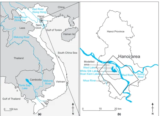
North Vietnam is essentially a mountainous region with elevations of about 200 m to more than 3000 m above sea level (Fig. 1). The region is characterized by the strait and narrow valley of the Red River which corresponds to the
0 100 km Laos Thailand Cambodia China Hainan Isl.
South China Sea Gulf of Tonkin Gulf of Thailand Vietnam Tonle Sap Lake Mekong River Mekong River Red River (Song Hong) Black River (Song Da) Hanoi Nam Dinh 0 10 20 km
White Silk Lake West Lake Duong River Red River Hanoi Province Nhue River Hoan Kiem Lake
(a) N (b) N
Modelled area
Hanoi area
Figure 1: a. Location of
Hanoi and its eponymous province in Vietnam. b. Location of the modelled area (light grey) in the Hanoi province. The lakes and rivers are shown in dark grey. The Hanoi area polygon indicates the zone where the Quaternary sedimentary architecture has been reconstructed.
Major Faults
Quaternary sediments Palaeozoic sedimentary rocks Metamorphic rocks
Granites
Mesozoic sedimentary rocks
0 50 km Viet Tri N Red River delta Red River DA PN DA Core PD DT ND-1 Hanoi Hai Phong Figure 2: Simplified
geological map of the Red River delta, showing the location of cores mentioned in the text. Redrawn after Mathers et al., 1996. Position of cores after Funabiki et al., 2007.
Red River graben (Mathers et al., 1996). The catchment area of the Red River is 155.000 km2 which is relatively
small compared to the major rivers in the world (Coleman & Roberts, 1989). The valley opens around Viet Tri to form a triangular-shaped plain with an altitude less that 200 m and which consists of Quaternary deposits (Fig. 2). The reach of the river in the delta plain is 225 km long (van Maren, 2005). This plain is generally called the Red River Delta (Tanabe et al., 2003a). In this context, the term delta is used in a geometric sense and does not indicate the depositional sedimentary environment. Therefore, the term “plain” will be used in this paper as it is more appropriate. At Hanoi the Red River splits into the Duong River which is debouching into a tide-dominated area in the East of the plain, and the Song Hong (Red River), crossing a fluvial-dominated area before debouching into a wave-dominated region in the West of the plain (Mathers et al., 1996; Mathers &Zalasiewicz, 1999) (Figs 1 & 2).
The study area comprises the urban area of Hanoi which is situated in the NW of the plain. The study area is bordered in the North and East by the Red River (Fig. 1). For the purpose of the hydrogeological modelling, the borders of the study area are irregular and are not defined according to natural boundaries. The western border is parallel to the Nhuê River at a distance of about 700 m of it. The investigated region includes the following lakes: West Lake, White Silk Lake, Hoan Kiem Lake (Fig. 1). 3. Previous work
The Red River plain has been investigated on the basis of few cores, 15 to 40 m deep with an undisturbed recovery and studied in detail supported by age determinations (Tanabe et al., 2003a, 2003b; Hori et al., 2004; Li et al., 2006; Funabiki et al., 2007). Since most of the cores are located in more seaward areas, no detailed information is available for the subsoil of the Hanoi area. The closest cores are at 20 km (DA core; Funabiki et al., 2007) and 25 km (PN core; Tran & Ngo, 2000) from Hanoi in the South and the SE, respectively, and one core at a distance of about 20 km West of the city (core PD; Funabiki et al., 2007; Fig. 2). The drillings have been carried out for the investigation of the sediment sequence, sea-level history and palaeogeography of the plain during the Holocene. According to Rau et al. (1991) the Holocene deposits of the Hanoi subsoil consist of sand, silt, clay and peat with a thickness varying between 10 and 45 m. Very little detail is known about the Pleistocene deposits that overly unconformably the Neogene deposits at a depth of 90 to 100 m in the centre of Hanoi (Rau et al., 1991). Their thickness reaches about 50 m beneath Hanoi and consists of fluvial gravels and sands with subordinate silt and clay lenses (Mathers & Zalasiewicz, 1999). The Pleistocene deposits form the main aquifer for water supply in Hanoi city (Rau et al., 1991).
The Red River plain formed by the progressive infill of an incised valley due to the relative sea-level rise during the Holocene. It is characterized by progradation once the
rate of the relative sea-level rise slowed down, after ca. 7-6 ka. According to the results of the above mentioned investigations, the infill starts with fluvial sediment accumulation (in the vicinity of Hanoi), which is described as river mouth bar (Tanabe et al., 2003b), probably representing a bay-head delta at the landward part of the estuary (cf. Zaitlin et al., 1994). It is overlain by tidal flat and tide-influenced channel-fill deposits (interpreted as estuarine sediments) at a depth between 16 and 11 m in core DA close to Hanoi (Fig. 2). These mainly clayey deposits are overlain by tide-influenced channel-fill deposits (interpreted as deltaic deposits) which reach a thickness of ca. 8 m (at a depth between 11 and 3 m). The upper 3 m is formed by floodplain deposits consisting of reddish brown clay with organic material at the base (Funabiki et al., 2007). The palaeogeographical reconstruction (Tanabe et al., 2003b) shows that coastal deposits reached as far as Hanoi between 9000 and 4000 a cal BP. However, according to Funabiki et al. (2007)the site of core DA, which is still about 20 km south of Hanoi, represents the landward limit of the coastal deposits, and fluvial deposition prevailed from ca. 7000 to 6000 a cal BP onwards. These ages should be considered with great care. The sequence with the deltaic deposits in particular has been dated on peaty material deposited in laminae which obviously indicates reworking. Also all shells are regarded as reworked material (Tanabe et al., 2003b). The palaeogeography is drawn on the basis of a compilation of sea-level curves from the western margin of the South China Sea (Tanabe et al., 2003b) completed with a sediment-accumulation curve derived from the investigated cores in the plain. The curve shows a rapid relative sea-level rise from 15,000 cal a BP onwards until 7500 a cal BP. Between 7500 and 2000 cal a BP (3500 cal BP according to Funabiki et al., 2007), it shows a higher sea-level stand than the present sea level. The data for the construction of the sea-level curve are derived from a multiplicity of coastal settings with considerable variations in the site-specific processes which influence the sedimentary record. Therefore, a difference in the interpretation of sea-level index points can be expected which explains the differences in ages. The curve does not consider the subsidence of the basin (at a rate of 0.04-0.12 mm/year, Tanabe et al., 2003b), nor sediment compaction which might be substantial in the deeper clayey deposits.
From the above-mentioned investigations, it can be inferred that in the study area coastal deposits (clay and sand) are probably present overlain by fluvial channel and floodplain deposits.
4. Data and methodology
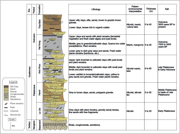
The data consists of the lithological description of 32 destructive drillings previously carried out in the Hanoi area (Fig. 1). The drillings recovered the entire Quaternary sequence. However, the description was not detailed and limited to the indication of solely the texture, i.e. gravel, sand, silt and clay, without note of further facies characteristics. In the data base (RIGMR, 2006), the
Quaternary deposits of the Hanoi Province are subdivided into “traditional stratigraphic formations” with a brief description of the lithology with some chronostratigraphical indication. The following formations are defined: Le Chi, Hanoi, Vinh Phuc, Hai Hung and Thai Binh (Ky et al., 1991; Mathers & Zalasiewicz, 1999). The chronostratigra-phical boundary between the Pleistocene and the Holocene is situated in the upper part of the Vinh Phuc Formation. The data obtained from the 32 drillings has been added to the description of these formations (Fig. 3).
As mentioned above, hydrogeological modelling requires understanding of the three-dimensional geometry of the deposits that are relevant for the groundwater flow. The Neogene deposits have not been considered because the shales are impermeable and can be considered as a hydrogeological barrier. To establish a three-dimensional geometry, the sedimentary sequence must first be presented in several cross-sections. For the correlation of the sediments in the cross-sections, the stratigraphic formations mentioned above, have not been used. The subdivision of estuarine and deltaic deposits into litho- or chronostratigraphic units is not very useful for delineating the facies or characteristic facies successions that can be used to interpret sedimentary sequences. Moreover, the sediment description of the stratigraphic formations is too
vague and individual units contain deposits with different texture and grain size which would lead to erroneous results in the hydrogeological model.
On the basis of the available sediment descriptions, lithological units have been selected whereby the dominant grain size was chosen to identify the unit. In the sediment descriptions, the silt and clay deposits of the entire Holocene sequence were grouped into one single unit. This unit comprises the silts and clays from the Vinh Phuc, Hai Hung and Thai Binh Formations (Fig. 3). However, it is most likely that this unit also contains sand bodies from active and abandoned channels.It is essential to identify these sand bodies from a hydrogeological point of view, because their presence would imply that there are multiple aquifers in the Holocene deposits although the data base only mentions one Holocene and one Pleistocene water level (RIGMR, 2006). The present-day channels have been identified on the geological map showing also the hydrographical network (Fig. 4). The ancient or buried channels have been detected by different means. Thus, the morphology of the lakes, ponds and fish ponds have been used to identify previous channel courses because they correspond to oxbow lakes (Tran, 2005). The spatial distribution of the observation wells gives an indication of the presence of sand, because no wells are drilled in clayey
Ba se m en t H an oi Vi nh P hu c H ai H un g Th ai B in h Le C hi Q ua te rn ar y Te rti ar y N eo ge ne Pl ei st oc en e H ol oc en e Silt-Clay Shale Legend Gravel Sand Conglomerate Sandstone Plant remains Alluvial fan Channel Peat Scale 5 m Fo rm at io n Pe rio d Er a
Shale, conglomerate, sandstone.
Grey clays with plant remains, gravely sandy lenses, fine sands with tree fragments.
Grey to brown clays, sands, polygenic gravels. Upper: dark brownish to yellowish clays with peat levels and plant remains.
Middle: dark brownish to yellowish clays with small peat levels and plant remains.
Lower: reddish to brownish/yellowish clays, yellow to grey sands and gravels. Fresh water plants remains. Upper: clays and sands with plant remains (terrestrial vegetation and fresh water algae) and peat levels. Middle: grey to greenish/yellowish clays. Scarce iron oxide precipitations. Plant remains.
Lower: grey to dark grey clays and sands. Fresh water plants remains (bamboos, etc.)
Upper: silty clays, silts, sands, brown to greyish brown gravels.
Lower: clays, lenses rich in organic matter. Alluvial, marsh, oxbow lake
Marsh, mangrove Alluvial marsh, lake Alluvial, alluvial fan Alluvial 0 to 40 5 to 25 8 to 60 3 to 35 3 to 25 Early Pleistocene Middle Pleistocene to basis of Late Pleistocene Late Pleistocene to Early Holocene Holocene 7000 to 3000 years BP Holocene 3000 years BP to present
Lithology environmental
Palaeo-interpretation Thickness(m) Age
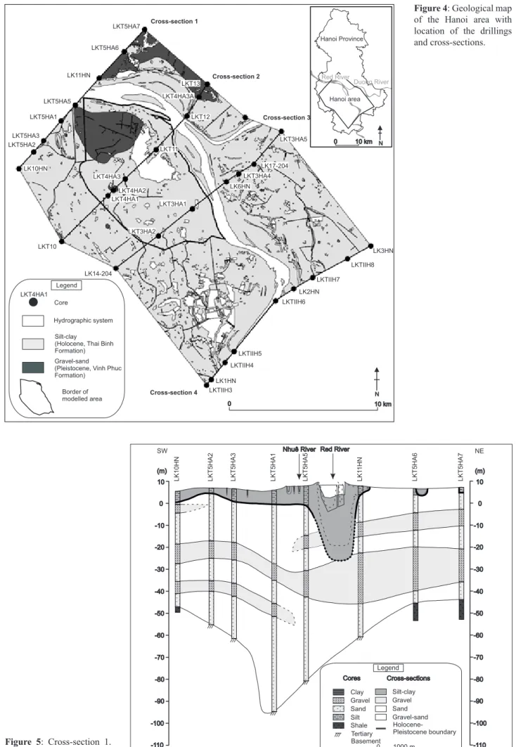
0 10 km Core
Hydrographic system Silt-clay
(Holocene, Thai Binh Formation) Gravel-sand (Pleistocene, Vinh Phuc Formation) LKT4HA1 Legend N 0 10 km Hanoi Province N Red River Duong River Hanoi area Cross-section 1 Cross-section 3 Cross-section 4 Cross-section 2 LK10HN LKT5HA2 LKT5HA1 LKT5HA3 LKT5HA5 LK11HN LKT5HA6 LKT5HA7 LK14-204 LKT4HA2 LKT4HA1 LKT4HA3 LKT11 LKT13 LKT4HA3A LKT12 LKT3HA1 LKT3HA2 LKT3HA4 LK6HN LK17-204 LKT3HA5 LK1HN LKTIIH3 LKTIIH5 LK2HN LKTIIH4 LKTIIH7 LKTIIH6 LKTIIH8 LK3HN LKT10 Border of modelled area NE LK 10 H N LK T5 H A2 LK T5 H A3 LK T5 H A1 LK T5 H A5 LK 11 H N LK T5 H A6 LK T5 H A7 10 0 -10 -20 -30 -60 -40 -50 -80 -90 -70 -100 -110 10 0 -10 -20 -30 -60 -40 -50 -80 -90 -70 -100 -110 SW Gravel Holocene-Pleistocene boundary Legend 0 1000 m Silt-clay Cores Cross-sections Sand Clay Sand Silt Gravel Shale Tertiary Basement Gravel-sand
Figure 4: Geological map
of the Hanoi area with location of the drillings and cross-sections.
Figure 5: Cross-section 1.
sequences. The thickness of the sand bodies which form the aquifers, has been inferred from the results of pumping tests (Jusseret et al., 2009). The sand bodies have been drawn on the cross-sections according to their distribution on the sequence map.
The boundary between the Pleistocene and Holocene deposits can be inferred from lithological and hydrological data. The top of the Pleistocene deposits consisting of fluvial gravel and sand or reddish brown compact clay, is relatively consolidated which is in contrast with the
overlying soft and fine-grained Holocene sediments deposited in a coastal and/or alluvial environment. The sedimentary boundary between them is sharp and can be recognized in every drilling at a level between +5 and –30 m msl. The Holocene clay with channel-sand bodies act as an aquifer representing a hydrogeological barrier that is likely to confine the underlying Pleistocene aquifer. The bottom of the river bed has been drawn on the cross-sections at an elevation of –2 m msl on the basis of measurements of the minimal water level of the Red River
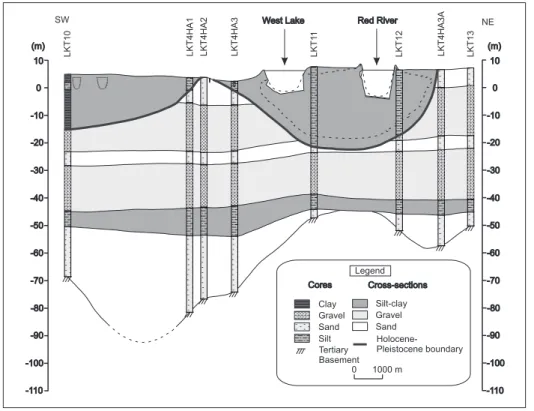
SW NE LK T1 0 LK T4 H A1 LK T4 H A2 LK T4 H A3 LK T1 1 LK T1 2 LK T4 H A3 A LK T1 3 10 0 -10 -20 -30 -60 -40 -50 -80 -90 -70 -100 -110 10 0 -10 -20 -30 -60 -40 -50 -80 -90 -70 -100 -110 (m) Gravel Holocene-Pleistocene boundary Legend 0 1000 m Silt-clay Cores Cross-sections Sand (m) Clay Sand Silt Gravel Tertiary Basement NE SW LK 14 -2 04 LK T3 H A2 LK T3 H A1 LK 6H N LK T3 H A4 LK 17 -2 04 LK T3 H A5 10 0 -10 -20 -30 -60 -40 -50 -80 -90 -70 -100 -110 10 0 -10 -20 -30 -60 -40 -50 -80 -90 -70 -100 -110 Gravel Holocene-Pleistocene boundary Legend 0 1000 m Silt-clay Cores Cross-sections Sand Clay Sand Silt Gravel Tertiary Basement Gravel-sand
Figure 6: Cross-section 2. See
Fig. 4 for location.
Figure 7: Cross-section 3. See
at three stations which was around +0.80 m in the period between 1995-2004. Since the river never dries up completely, an arbitrarily water depth around 3 m was chosen.
5. Results
5.1. Description of the cross-sections
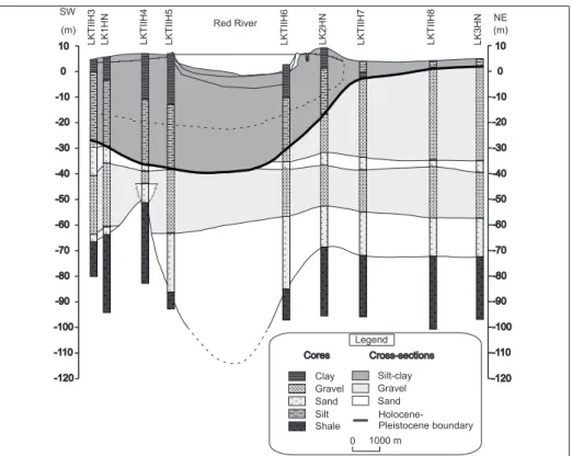
A series of 4 cross-sections (Figs 4-8) from North to South have been drawn to show some details of the spatial distribution of the units. The cross-sections have been drawn with a vertical exaggeration of 100 resulting in a false impression of the geometry of the units like, for example, the Pleistocene palaeovalley of the river which in reality has very gentle slopes. The cross-sections show a major depression around –90 m in the top of the Neogene deposits which corresponds to a former valley. The valley is particularly well expressed in the northern section and widens towards the South. It is filled with Pleistocene sand and gravel with a thickness ranging between 30 and 90 m which is much more than the 50 m mentioned in the literature. An almost 10 m thick clay/silt unit is only present on Fig. 6 and Fig. 7 at a depth of -40/-50 m and -50/-60 m, respectively. The unit is likely to be a floodplain deposit and therefore, is of greater importance for the hydrogeology than the clay and silt lenses described in literature (cf. Mathers & Zalasiewicz, 1999).
The Pleistocene sands and gravels are unconformably overlain by the Holocene deposits. The erosive character of the incised valley, formed during a sea-level low stand, is very well expressed. The thickness of the Holocene deposits is generally 20 m and reaches about 30 m in the South of the study area. In the North, the deposits are restricted to the palaeovalley and form a thin cover west
of it. This suggests that here only fluvial processes have been active and that this area was beyond the influence of coastal deposition. The silt/clay unit has a wider extension and occurs at greater depth towards the South, where it is probably formed by coastal processes in an estuarine environment. The variously sized and shaped sand bodies most probably represent the deposits of channels. 5. 2. Panel diagram
The geometry of the different sediment units becomes clear in the panel diagram (Fig. 9) which demonstrates the interrelationship between the cross-sections and gives a general overview of the spatial extension of the relevant units. The Holocene sand bodies have not been represented for the sake of clarity. The diagram shows that the Pleistocene gravel units become thicker towards the SE while in the northern part, sand dominates. The Holocene clay/silt unit is restricted and even completely absent in the NE. In the northern part, the unit mainly occurs in the valley of the Red River while further South, it is more widely spread. This particular geometry demonstrates the infill of the incised valley during the Holocene. The geometry of the depositional bodies indicates a change in sedimentary style between the Pleistocene and Holocene units. The change most likely occurred at the onset of the Holocene with a re-organization of the fluvial system as a result of relative sea-level rise.
5.3. Morphology of the Neogene basement
The contour map of the top of the Neogene deposits (base of the Quaternary deposits) is constructed on the basis of the interpretation in the cross-sections (Fig. 10). The depth ranges between –45 m in the North and –110 m in the South which represents a significant relief. The apparent
NE SW LK TI IH 3 LK 1H N LK TI IH 4 LK TI IH 5 LK TI IH 6 LK 2H N LK TI IH 7 LK TI IH 8 LK 3H N 10 0 -10 -20 -30 -60 -40 -50 -80 -90 -70 -100 -110 10 0 -10 -20 -30 -60 -40 -50 -80 -90 -70 -100 -110 -120 -120 Red River Gravel Holocene-Pleistocene boundary Legend 0 1000 m Silt-clay Cores Cross-sections Sand Clay Sand Silt Gravel Shale (m) (m)
Figure 8: Cross-section 4. See
existence of several depressions with a similar depth is an artefact of the low density of data points and not necessarily reality. It is most likely that they represent the valley of the Red River and/or its tributaries. Since the depositional evolution during the Pleistocene is not documented, it is impossible to know when the valleys were initially formed and/or whether they have been scoured and reoccupied in different periods. The location of the depression coincides with the location of the major faults (Fig. 2). This map shows that already in the top of the Neogene deposits, a valley is well expressed.
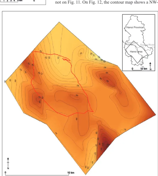
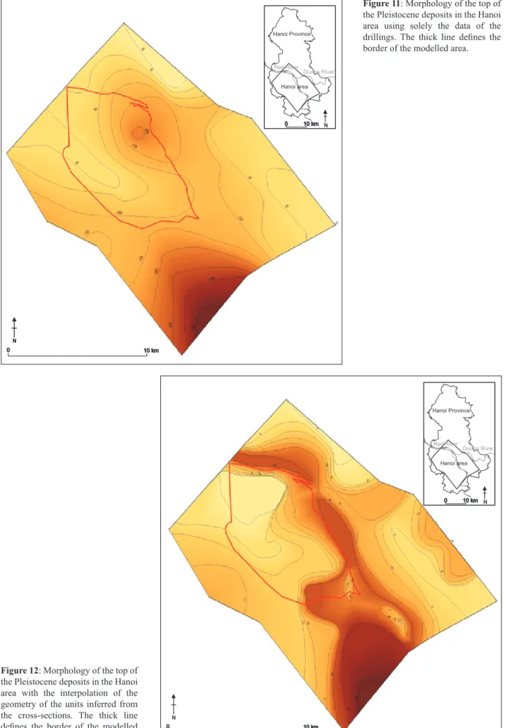
5.4. Morphology of the base of the Holocene deposits The boundary between the Pleistocene and Holocene deposits (Figs 11 & 12) represents a hydrogeological barrier and a map of its surface indicates the depth of the relatively consolidated sediments with a significant bearing capacity, in contrast with the overlying soft sediments. The map is based on interpolation between a small number of widely scattered boreholes and should be treated with caution. A more realistic picture of the top of the Pleistocene deposits is obtained by adding data inferred from the cross-sections (Fig. 12). For instance, palaeochannels inferred from the present-day hydrographical network are represented on Fig. 12 and not on Fig. 11. On Fig. 12, the contour map shows a
NW-LK 10 H N LK T5 H A3 LK 11 H N LK T5 H A7 LK T1 0 LK T4 H A2 LK T4 H A3 LK T4 H A1 LK T1 1 LK T1 2 LKT4 H A3 A LK T1 3 LK T5 H A2 LK T5 H A1 LK T5 H A5 LK T5 H A6 LK TI IH 3 LK 6H N LK T3 H A5 LK T3 H A2 LK T3 H A1 LK 17 -2 04 LK T3 H A4 LK 14 -2 04 LK 1H N LKTI IH 4 LK TI IH 5 LK 2H N LK TI IH 6 LKTI IH 7 LK TI IH 8 LK 3H N Gravel Holocene-Pleistocene boundary Legend Silt-clay Sand LK TI IH 4 Coring 1 2 3 4 5 km 20 40 m N 0 10 km N 0 10 km Hanoi Province N Red River Duong River Hanoi area
Figure 9: Panel diagram drawn
on the basis of the
cross-sections. Holocene river
channels have not been represented for the sake of clarity.
Figure 10: Morphology of the
Neogene basement in the Hanoi area. The thick line defines the border of the modelled area.
0 10 km N N 0 10 km Hanoi Province N Red River Duong River Hanoi area 0 10 km N 0 10 km Hanoi Province N Red River Duong River Hanoi area
Figure 11: Morphology of the top of
the Pleistocene deposits in the Hanoi area using solely the data of the drillings. The thick line defines the border of the modelled area.
Figure 12: Morphology of the top of
the Pleistocene deposits in the Hanoi area with the interpolation of the geometry of the units inferred from the cross-sections. The thick line defines the border of the modelled area.
SE depression which corresponds to the Pleistocene palaeovalley of the Red River. The valley is rather narrow in the North and becomes deeper towards the South. However, the wider part in the South might result from the low density of data. It is possible that here some meanders have been linked.
5.5. Sequence map
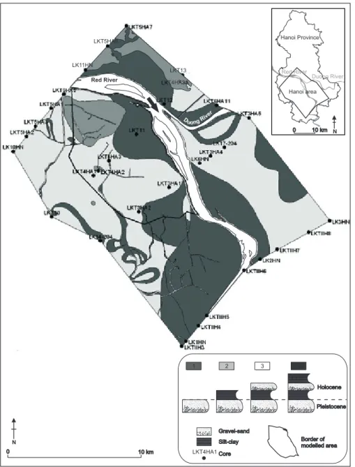
The sequence map (Fig. 13) differs from conventional geological maps which represent the geographical distribution of the outcropping deposits. In alluvial or coastal plains, characterized by a high lithological variability in the subsoil, such maps are of little use (cf. Fig. 4). The variability in the subsoil, however, is shown in a sequence map. The method consists of constructing a series of profile types each identified by a particular colour or symbol. A profile type represents a typical vertical succession of units.
For the study area, four simple profile types have been selected with the following units: a gravel-sand unit and a
clay-silt unit, both from the Pleistocene and the Holocene (Fig. 13). The silt and clay in the lower part of the Pleistocene deposits have not been considered because their spatial distribution is not sufficiently known. Although the sequence map is a simplified interpretation of the data, nevertheless it shows a general picture of the spatial distribution of the Quaternary deposits. A restricted part in the North consists solely of Pleistocene sand and gravel (profile type 1) and Holocene deposits are absent. The narrow central part of the map (profile type 3) corresponds with the present-day river deposits underlain by Holocene clay with organic matter, in turn underlain by Pleistocene gravel and sand. The area adjacent to the narrow zone consists of Holocene floodplain clay at the top underlain by sand and gravel representing former channel courses of the river (profile type 4). The channel sand overlies the Holocene clay with organic matter which covers the Pleistocene gravel and sand. A major part of the map shows the presence of only Holocene floodplain clay upon Pleistocene gravel and sand (profile type 2). This way of representation is relevant for hydrogeological
0 10 km 0 10 km N Hanoi Province N Red River Duong River Red River r e vi Duon gR Silt-clay Core LKT4HA1 LKT4HA1 Pleistocene Holocene Gravel-sand Border of modelled area Hanoi area LKT13 LK11HN LKT4HA3A LKT5HA6 1 2 3 4
Figure 13: Sequence map of the
Hanoi area. See text for explanation.
purposes, because the map shows that there are no Holocene aquifers present in the areas represented by profile types 1 and 2. A sequence map does not give an indication of the thickness of the units, therefore, it must be accompanied by a contour map like, for example, Fig. 12.
6. Interpretation of the Holocene sedimentary sequence
Data derived from previous research in the plain, together with the geometry of the units obtained in this study, suggest that the Holocene sediment succession formed as a result of the post-glacial sea-level rise flooding of an incised-valley system. The system probably originated as an erosional valley, formed by river action during the Late Glacial sea-level low stand. The valley fill likely began to accumulate near to the end of the low stand and comprises sediments deposited during the following base-level rise (Dalrymple et al., 1994). Studies elsewhere demonstrate that during rapid sea-level rise, fluvial sediment supply is often less than the rate at which accommodation space is created. As a result, an estuary develops at the mouth of the incised valley. The estuary and associated sedimentary subenvironments then migrate landwards during the transgression, stabilizing only as the rate of relative sea-level rise falls to zero. From this point onwards, sediment input from fluvial and marine sources leads to the development of deltaic or coastal-plain progradation (Kraft & Chrzastowski, 1985; Reinson, 1992; Dalrymple et al., 1992; Dalrymple et al., 1994). In the present study area, relative sea-level rise stabilized around 3000-2000 a cal BP.
The existing data do not enable us to identify whether the study area at the landward end of the valley lay beyond the limit of the estuarine influence and remained wholly fluvial. At the landward limit of the Holocene transgression, Holocene fluvial sediments are normally deposited by the inflowing river as an alluvial floodplain or bay-head delta (cf. Zaitlin et al., 1994). These deposits were interpreted by Tanabe et al. (2003a) as forming in a river-bar mouth. The absence of fluvially-cut valleys at the start of the marine inundation at the beginning of the Holocene, can be accounted for by an initially rapid transgression and a low rate of fluvial sedimentation. This is generally the case in smaller valleys like, for example, the Delaware River, USA, which has a length comparable to the Red River (Ashley & Sheridan, 1994).
The lithostratigraphic cross-sections show that the Holocene mud and silt are generally confined to the palaeovalley. The thickness of the deposits increases towards the south and decreases away from the valley. No estuarine sediments were found in core PD which is located west of Hanoi and at the landward limit of the plain. However, according to previous work, it is most likely that at least the lower part of the mud and silt was deposited in an estuarine environment. The lowest unit (Unit 1) reaches a thickness of 5 m in core DA; 5 to 10 m in core DT, and 20 m in core ND-1 at 50 and 80 km
distance from the study area, respectively. The increasing thickness of this unit downstream confirms that the study area was most likely situated at the head of the estuary where the strong mixing of fresh and saline water results in a concentration of muddy deposition, often as intertidal mudflats (Carter, 1988; Pye, 1994; Healy, 2005). When muds are deposited under relatively low-energy conditions like in intertidal flats, they are little affected by subsequent channelling. In addition, plant growth also protects the muddy sediments from erosion (Einsele, 1992). Estuaries are usually fringed by tidal flats with mangrove and salt marshes. The plant remains described in the early Holocene deposits (cf. Fig. 3) most likely originate from mangrove vegetation. The latter, however, was uncommon before 6000 a cal BP when relative sea-level was rising quickly (Chappell & Woodroffe, 1997). In this period, mangrove was likely confined to sheltered sites where they could persist on the vertically accreting muddy substrates as submergence occurred (Bird, 2000).
In most simplified stratigraphic models, the upper portion of the transgressive succession is removed by shoreface or tidal channel erosion as the estuary continues to translate landward under sea-level rise (Reinson, 1992; Dalrymple et al., 1992; Dalrymple et al., 1994). In our study area, however, the shoreface did not reach that far and the estuarine mud is overlain by freshwater floodplain sediments which accumulated when sea level stabilized once the estuary was filled. According to Funabiki et al. (2007), fluvial deposition prevailed in the landward portion of the valley from ca. 7000-6000 a cal BP onwards. More seaward in the rest of the plain, estuarine infilling continued. The sediments are described as deltaic deposits overlying conformably Unit 1 (Tanabe et al., 2003a; Funabiki et al., 2007). The sedimentary characteristics of these deposits, including the heterolithic nature of the laminated mud and sand, together with burrowing, suggest tide-influenced sedimentation in the central portion of the estuary.
In summary, a comparison of the results obtained in this study with the scattered cores in the plain indicates that the Hanoi sediment succession developed in an incised valley under conditions of rapid relative sea-level rise until ca. 7-6 ka a cal BP. The succession consists initially of alluvial floodplain deposits or a bay-head delta conformably overlain by mud deposited at the head of an estuary which became an area of vertical accretion with continuing rapid sea-level rise. Once the relative sea-level rise stabilized at about 7-6 ka a cal BP, fluvial deposition prograded over the adjacent estuarine mud.
Further detailed comparison to previous models, in terms of chronology or particular facies succession, is not possible. Although all sequences, originating from relative sea-level changes, show principally the same succession, their lithologies and stratigraphic expressions vary spatially enormously. The sediment infill of an estuarine/ deltaic complex is time- and space dependent (Leeder, 1999) and reflects processes operating at a given time, which may not be representative of the entire estuarine/ deltaic cycle.
7. Conclusion
In this paper the Quaternary sequence of the subsurface of the central part of Hanoi has been presented for the first time. The broad reconstruction of the geometry of the sedimentary bodies demonstrates that the Quaternary deposits reach a much greater thickness than previously believed. The existence of a palaeovalley in Pleistocene times is documented by a major depression in the top of the Neogene deposits that coincides with the location of the major faults. During Pleistocene times, coarse-grained fluvial sedimentation prevailed. Today, these units form important groundwater aquifers. The geometry of the Holocene deposits shows that Pleistocene sediments have been incised to form a second palaeovalley. Assuming that the area of Hanoi is at the landward limit of the Holocene coastal plain, it is likely that the palaeovalley was initially infilled by marine deposits. The lithological heterogeneity of the marine and fluvial sediments, although an important factor for modelling groundwater flow, could not be documented in detail because of the paucity of available data.
The methodology applied in this investigation has succeeded in overcoming limitations in the primary dataset by providing the basic stratigraphic data which are needed for the construction of a three-dimensional groundwater flow model (Fetter, 2001). This methodology shows that particular attention must be paid to limitations as result of a low density of data points. The results of this investigation can form a basis for subsequent geotechnical studies. The broad reconstruction of the geometry of the sedimentary bodies and the contour maps can be used to the preliminary identification of compressible units like the Holocene clay and silt which have a much lower bearing capacity than the relatively more consolidated Pleistocene deposits.
8. Acknowledgement
The authors are grateful to V.T. Tam and N.X. Khien (RIGMR) for their hospitality and welcome during the three weeks spent by the first author in Hanoi in February 2006. We also thank the RIGMR for authorizing the use of their data collected in the frame of the UNESCO project. F. Boulvain (ULg) is thanked for having promoted this work. We wish to thank Prof. Dr. A. Long for the constructive comments and the language corrections, as well as an anonymous reviewer for suggestions.
9. References
ASHLEY, G.M & SHERIDAN, R.E., 1994. Depositional model for valley fills on a passive continental margin. In Dalrymple, R.W., Boyd, R. & Zaitlin, B.A., (eds),
Incised-valley systems: Origin and sedimentary sequences. SEPM
Special Publication, 51. The Society of Economic Paleontologists and Mineralogists, Tulsa, 285-301.
BAETEMAN, C., 1994. Subsidence in coastal lowlands due to groundwater withdrawal: The geological approach.
Journal of Coastal Research Special Issue, 12: 61-75.
BIRD, E., 2000. Coastal Geomorphology. An Introduction. John Wiley & Sons, Chichester.
CARTER, R.W.G., 1988. Coastal Environments. An
introduction to the Physical, Ecological and Cultural Systems of Coastlines. Academic Press, London.
CHAPPELL, J. & WOODROFFE, C.D., 1997. Macrotidal estuaries. In Carter, R.W.G. & Woodroffe, C.D., (eds),
Coastal evolution. Late Quaternary shoreline
morphodynamics. Cambridge University Press,
Cambridge, 187-218.
COLEMAN, J.M. & ROBERTS, H.H., 1989. Deltaic coastal wetlands. Geologie en Mijnbouw, 68: 1-24. DALRYMPLE, R.W., BOYD, R. & ZAITLIN, B.A., 1994. History of research, types and internal organisation of incised-valley systems: Introduction to the volume. In Dalrymple, R.W., Boyd, R. & Zaitlin, B.A., (eds),
Incised-valley systems: Origin and sedimentary sequences. SEPM
Special Publication, 51. The Society of Economic Paleontologists and Mineralogists, Tulsa, 3-10.
DALRYMPLE, R.W., ZAITLIN, B.A. & BOYD, R., 1992. Estuarine facies models: Conceptual basis and stratigraphic implications. Journal of Sedimentary
Petrology, 62(6): 1130-1146.
EINSELE, G., 1992. Sedimentary Basins. Evolution,
Facies, and Sediment Budget. Springer-Verlag, Berlin.
FETTER, C.W., 2001. Applied Hydrogeology, Fourth
Edition. Prentice-Hall, Upper Saddle River, New Jersey.
FUNABIKI, A., HARUYAMA, S., QUY, N.V., HAI, P.V. & THAI, D.H., 2007. Holocene delta plain development in the Song Hong (Red River) delta, Vietnam. Journal of
Asian Earth Sciences, 30: 518-529.
GANGOPADHYAY, S. & DAS GUPTA, A., 1995. Simulation of salt-water encroachment in a multi-layer groundwater system, Bangkok, Thailand. Hydrogeology
Journal, 3(4): 74-88.
HEALY, T.R., 2005. Muddy coasts. In Schwartz, M., (ed.), Encyclopedia of coastal science. Springer-Verlag, Dordrecht, 674-677.
HORI, K., TANABE, S., SAITO, Y., HARUYAMA, S., NGUYEN, V. & KITAMURA, A., 2004. Delta initiation and Holocene sea-level change: Example from the Song Hong (Red River) delta, Vietnam. Sedimentary Geology, 164: 237-249.
JUSSERET, S., TAM, V.T. & DASSARGUES, A., 2009. Groundwater flow modelling in the central zone of Hanoi, Vietnam. Hydrogeology Journal, 17(4): 915-934.
KOPONEN, H., 1991. Estimating the effects of ground water lowering in Hanoi. Proceedings, Ninth Asian Regional Conference on Soil Mechanics and Foundation Engineering, Bangkok, Thailand, 401-404.
KOSTIC, B. & AIGNER, T., 2007. Sedimentary architecture and 3D ground-penetrating radar analysis of gravelly meandering river deposits (Neckar Valley, SW Germany). Sedimentology, 54: 789-808.
KRAFT, J.C. & CHRZASTOWSKI, M.J., 1985. Coastal stratigraphic sequences. In Davis Jr., R.A., (ed.), Coastal
sedimentary environments. Springer-Verlag, New York,
625-663.
KY, H.N., DY, N.D., MEN, N.N. & NGA, D.D., 1991. Quaternary stratotypes in the Red River’s lower plain of Vietnam. In United Nations. Economic and Social Commission for Asia and the Pacific (ed.), Quaternary
stratigraphy of Asia and the Pacific, IGCP 296 (1989).
Mineral Resources Development Series 60. United Nations, New York, 105-106.
LEEDER, M., 1999. Sedimentology and Sedimentary
Basins. From Turbulence to Tectonics. Blackwell Science,
Oxford.
LI, Z., SAITO, Y., MATSUMOTO, E., WANG, Y., TANABE, S. & VU, Q.L., 2006. Climate change and human impact on the Song Hong (Red River) delta, Vietnam, during the Holocene. Quaternary International, 144: 4-28.
MATHERS, S., DAVIES, J., MCDONALD, A., ZALASIEWICZ, J. & MARSH, S., 1996. The Red River
delta of Vietnam: A demonstration of the applicability of sedimentology to the investigation of unconsolidated sedimentary aquifers. British Geological Survey Technical
Report WC/96/02. British Geological Survey, Keyworth, Nottingham.
MATHERS, S. & ZALASIEWICZ, J., 1999. Holocene sedimentary architecture of the Red River delta, Vietnam.
Journal of Coastal Research, 15(2): 314-325.
NGUYEN, T.Q. &HELM, D.C., 1998. Land subsidence due to groundwater withdrawal in Hanoi, Vietnam. In James, W., (ed.), Land subsidence. Case studies and
current research. Proceedings of the Dr. Joseph F. Poland symposium on land subsidence. Association of Engineering
Geologists Special Publication 8. Star Publishing Company, Belmont, Canada, 113-117.
NGUYEN, T.B.H. & NURUL AMIN, A.T.M., 2002. The role of foreign direct investment in urban environmental management: Some evidence from Hanoi, Vietnam.
Environment, Development and Sustainability, 4:
279-297.
PYE, K., 1994. Sediment Transport and Depositional
Processes. Blackwell Scientific Publications, Oxford.
RAU, J.L., NUTALAYA, P., TRAN, V.H. & NGUYEN, Q.T., 1991. The problems of land subsidence in the world
and in Vietnam. Proceedings, Second Conference of
Indochina, Hanoi, Vietnam, 421-428.
REINSON, G.E., 1992. Transgressive barrier islands and estuarine systems. In Walker, R.G. & James, N.P., (eds.),
Facies models. Response to sea-level change. Geological
Association of Canada, Love Printing Service, Ontario, 179-194.
RIGMR, 2006. Research Institute of Geology and Mineral Resources unpublished database. Hanoi, Vietnam.
TANABE, S., HORI, K., SAITO, Y., HARUYAMA, S., DOANH, L.Q., SATO, Y. & HIRAIDE, S., 2003. Sedimentary facies and radiocarbon dates of the Nam Dinh-1 core from the Song Hong (Red River) delta, Vietnam. Journal of Asian Earth Sciences, 21: 503-513. TANABE, S., HORI, K., SAITO, Y., HARUYAMA, S., VU, V.P. &Kitamura, A., 2003. Song Hong (Red River) delta evolution related to millennium-scale Holocene sea-level changes. Quaternary Science Reviews, 22: 2345-2361.
THU, T.M., 1998. Subsidence due to the pumping of groundwater in the city of Hanoi, Vietnam. M. Sc. thesis, University of Saskatchewan, Saskatoon.
THU, T.M. & FREDLUND, D.G., 2000. Modelling subsidence in the Hanoi city area, Vietnam. Canadian
Geotechnical Journal, 37(3): 621-637.
TRAN, N., 2005. Quaternary sedimentation of Red River
delta in relation to groundwater potential. Unpublished
Power Point presentation, Hanoi University of Science, Vietnam National University, Hanoi.
TRAN, N. & NGO, Q.T., 2000. Development history of deposits in the Quaternary of Vietnam. In Nguyen, T.V., (ed.), The weathering crust and Quaternary sediments in
Vietnam. Department of Geology and Minerals of Vietnam,
Hanoi, 177-192 (in Vietnamese).
VAN MAREN, D.S., 2005. Barrier formation on an actively prograding delta system: The Red River delta, Vietnam. Marine Geology, 224: 123-143.
ZAITLIN, B.A., DALRYMPLE, R.W. & BOYD, R., 1994. The stratigraphic organization of incised-valley systems associated with relative sea-level change. In Dalrymple, R.W., Boyd, R. & Zaitlin, B.A., (eds), Incised
valley systems: Origin and sedimentary sequences. SEPM
Special Publication 51. Society of Economic Paleontologists and Mineralogists, Tulsa, 45-60
(Manuscript received 18.02.2009; accepted in revised form 26.06.2009; available on line 15.07.2009)