Accepted Manuscript
Title: Growing on the street: Multilevel correlates of street tree growth in Montreal
Authors: Sophie Limoges, Thi-Thanh-Hien Pham, Philippe Apparicio PII: S1618-8667(17)30557-5 DOI: https://doi.org/10.1016/j.ufug.2018.01.019 Reference: UFUG 26066 To appear in: Received date: 15-9-2017 Revised date: 9-1-2018 Accepted date: 20-1-2018
Please cite this article as: Limoges, Sophie, Pham, Thi-Thanh-Hien, Apparicio, Philippe, Growing on the street: Multilevel correlates of
street tree growth in Montreal.Urban Forestry and Urban Greening
https://doi.org/10.1016/j.ufug.2018.01.019
This is a PDF file of an unedited manuscript that has been accepted for publication. As a service to our customers we are providing this early version of the manuscript. The manuscript will undergo copyediting, typesetting, and review of the resulting proof before it is published in its final form. Please note that during the production process errors may be discovered which could affect the content, and all legal disclaimers that apply to the journal pertain.
Title : Growing on the street: Multilevel correlates of street tree growth in Montreal
Authors :
Sophie Limoges, Graduated Master degree – Urban studies
Address : Département d’étude urbaines et touristiques, Université du Québec à Montréal. 315, rue Sainte-Catherine Est, Montréal (Québec) H2X 3X2. Canada Email : [email protected]
Thi-Thanh-Hien Pham, Associate professor
Address : Département d’étude urbaines et touristiques, Université du Québec à Montréal. 315, rue Sainte-Catherine Est, Montréal (Québec) H2X 3X2. Canada Email : [email protected]
Philippe Apparicio, Professor
Address : Institut national de la recherche scientifique, Centre Urbanisation Culture Société. 385, rue Sherbrooke Est Montréal (Québec) H2X 1E3. Canada
Email : [email protected]
Abstract :
Tree planting has been favoured in many North American cities, including Montreal
which aims to increase its canopy from 20% to 25% in 2025. However, the mortality rate
of street trees is especially high in the first few years after planting. Studies have shown
that variables that are intrinsic to the tree and those related to its location, the urban
form and the socio-demographic characteristics of the surrounding environment are
significantly associated either with trees’ survival rate or with vegetation cover. In this
research we examine variables that have statistical associations with tree growth, which
is the diameter at breast height divided by the number of years on the ground, for
approximately 28,000 street trees in Montreal. Independent variables were nested into
three spatial scales: the tree (species and physical variables), the street section (urban
form variables), and the census tract (socio-demographic variables). Multilevel models
reveal that 65.51% of the growth variance is potentially explained by the species and
planting physical conditions such as the east and north sides (positive associations with
the growth), signage as an obstruction (negative association). 28.54% of the grow
variance is potentially explained by the urban form, in our case building age (convex
relationship with the growth), mixed zoning (negatively) and residential zoning
(positively). At the neighbourhood level, although none of our variables is significant,
6.95% of the growth variance is be potentially explained by other missing variables. New
planting programs should hence consider the urban form in order to improve tree
growth.
Keywords : street trees, tree growth, planting conditions, urban form, multilevel models
Highlights:
Correlates of street tree growth are analyzed at the three spatial scales
Tree species and their planting conditions are predominant
Urban form has smaller associations with tree growth
Socio-demographic variables are not significant
Planting can be more efficient when considering multilevel factors on street trees.
Introduction
The benefits of trees, whether from an environmental, economic or social perspective, have been extensively demonstrated in numerous studies. Trees are a major asset in combatting air pollution and heat-island effects, in rainwater management, and in public health programs, especially since trees help to prevent and reduce stress and encourage the practising of physical activities (de Vries, van Dillen, Groenewegen, & Spreeuwenberg, 2013; Mullaney, Lucke, & Trueman, 2015; Nowak, Crane, & Stevens, 2006; Roy, Byrne, & Pickering, 2012). In the current environmental context, largely linked to climate change, urban forests play a crucial role and are attracting the attention of governments, researchers and citizens. North American cities have therefore begun to invest in the planting and protection of urban trees (Hubacek & Kronenberg, 2013), by launching campaigns such as “One million tree” in the United States (McPherson, Simpson, Xiao, & Wu, 2011; Morani, Nowak, Hirabayashi, & Calfapietra, 2011) and 300,000 trees in Montreal (City of Montréal, 2011), our study area.
Nevertheless, unlike natural forests, urban forests are created and managed by human beings (Clark, Matheny, Cross, & Wake, 1997; Sanders, 1984) through a number of interventions such as planting, maintenance, removal and replacement (Roman, Battles, & McBride, 2014). The urban environment imposes more difficult living conditions on trees. Indeed, for species of the same age, trees in the urban environment generally have a smaller diameter at breast height (DBH) and thus a lower growth rate than trees in the woods (Quigley, 2004). The most common causes of mortality in newly-planted trees are hydric stress (Foster & Blaine, 1978; Nielsen, Bühler, & Kristoffersen, 2007; Whitlow, Bassuk, & Reichert, 1992) and damage resulting from vandalism (Jim, 1987; Richardson & Shackleton, 2014).
Trees in urban settings also tend to have a shorter average life expectancy than trees in suburban environments (Moll, 1989). However, the average life expectancy for street trees varies from study to study: 7 years (Moll, 1989), 10 years (Foster & Blaine, 1978), 15 years (Nowak, Kuroda, & Crane, 2004), and between 19 and 28 years (Roman & Scatena, 2011).
Several studies have also shown that the annual mortality rate for trees in urban environments, and particularly for street trees, ranges from 3% to 9.97% (Impens & Delcarte, 1979; Lawrence, Escobedo, Staudhammer, & Zipperer, 2012; Nowak et al., 2004; Roman et al., 2014; Roman & Scatena, 2011) and may reach up to 19% (Nowak, McBride, & Beatty, 1990). In this regard, street trees are more vulnerable in the first few years after planting (Roman et al., 2014). A number of studies have evaluated the losses as varying from 9% to 19.5% in the first year (Impens & Delcarte, 1979; Roman et al., 2014), 17% to 34% in the second year (Nowak et al., 1990; Roman et al., 2014), 25% after three years (Roman et al., 2014), and 50% after four years (Miller & Miller, 1991). Trees studied by Lu et al. (2010) shows between 6 and 9 years, the mortality rate becomes stable (Lu et al., 2010). This body of literature is informative but
comprehensive and systematic investigations of all factors influencing tree growth rather rare. Yet understanding the role of those factors is important in order to properly manage the planting and maintenance of trees in the specific conditions of urban environments.
The main objective of this article is to examine the associations of three groups of variables—that is, biological and physical, urban form, and socio-demographic conditions—with the growth of street trees in Montreal while considering each variable within its own scale of analysis. The growth of street trees is computed by deviding tree size (measured by the diameter at breast height) by the number of years that the tree is on the ground. The study tries to answer the following research questions: i) How is the variance in the growth distributed on the three levels (the tree, the urban form context, and the socio-demographic context)? ii) What is the associations of each variable on the tree size? To answer to these questions, we relate the growth of trees to independent variables such as the trees’ biological and physical characteristics, urban form (measured at the street section level), and socio-demographics (measured at the census tract level) by using multilevel statistical models. The biological and physical variables are examined on the level of individual trees (species, types of location, types of obstructions, and geographic
orientations). The urban form variables are considered on the level of street sections (median age of buildings, types of housing). Finally, the socio-demographic variables are examined on the level of census tracts (immigration, tenure mode, education, housing value, life stage). Recent research on urban forest suggests that the multilevel modelling is better-suited for the study of urban vegetation that is influenced by multiple variables operating at several spatial scales (Locke, Landry, Grove, & Roy Chowdhury, 2016; Pham, Philippe, Landry, & Lewnard, 2017). More importantly, multi-level models prove to be able to partion variation attributed to each group of variables (according to their scale) and to generate results that are more robust. We
hence opt for multilevel models in this research. In our case, the analyses are performed on a very fine scale (each tree), and in considering the urban form around each tree, which enables us to obtain a quantitative and precise evaluation of the associations of the variables. Moreover, it is important to examine whether street tree growth is associated with the socio-demographic context in order to better inform public policies related to urban forest management.
The study area is the City of Montreal as it was before the municipal mergers of 2002: that is, nine of the current nineteen Montreal boroughs (Figure 1). The boroughs were chosen according to the availability of tree inventories and the database on street sections. The area of the study is 164 km², and the street tree canopy percentage is assessed at 5.45% (Pham, Apparicio, Séguin, & Gagnon, 2011).
<< Figure 1 >>
Literature review and research design
In order to understand the variables influencing tree growth, the literature review here focuses on urban tree mortality and theories explaining vegetation cover and trees in the city. In general, the variables are grouped into three categories: biological and physical variables, urban form
variables, and socio-demographic variables. To make our literature review exhaustive we present here all studies pertaining on tree mortality, mortality rate, growth, size as well as tree cover.
Biological and physical variables
The biological and physical variables correspond to Level 1 (the tree). They are often documented in studies dealing with urban tree mortality. First, the specific characteristics of trees—biological variables such as the species and age—are closely linked to the DBH and are important to consider when examining growth and life expectancy (Koeser, Hauer, Norris, & Krouse, 2013; Lesser, 1996; Miller & Miller, 1991). Stoffberg et al. (2008) have shown that tree growth and diameter vary according to the species. The age of the tree at the time of planting also seems to have an association to young trees and small trees are more vulnerable than mature trees (Koeser et al., 2013; Nowak et al., 2004). However, age of tree at the the time planting is not always available in databases, such as in our case. We could not examine this variable in this study. Physical variables are associated with the tree’s immediate environment and living conditions. They refer to the types of location, soil characteristics, stress, and damage (Quigley, 2004). The mortality rate increases when trees are affected by poor site conditions: that is, little space for
developing roots, compacted and inappropriate soil, and lack of care and maintenance (Pauleit et al., 2002). The trunk diameter is correlated to the root spread, suggesting that the bigger the space and the root spread are, the larger the tree trunk is (Grabosky & Gilman, 2004). Urban trees are generally planted in a sidewalk cutout, on a sidewalk planting strip next to the curb, or on a border along the inner edge of the sidewalk. For example 94% of the trees studied by Lu et al. (2010) were planted in a sidewalk cutout and had a 76.1% survival rate.
Variables related to the urban form and socio-demographic context
Concerning the variables related to the urban form and socio-demographic context where the public tree is located, we present them according to theories that explain their associations with trees’ development and cover: population density, urban form, social stratification and an ecology of prestige. The variables documented in the literature and the corresponding theories are
summarized in Table 1.
<< Table 1 >>
Given the small body of literature on street trees, in the following review we present studies on urban vegetation or urban trees in general. Although trees in our tudy are under municipally led management, it is important to consider all the documented urban form variables and test them in the models. The urban form variables correspond to Level 2 (street section). At this level, several variables linked to population density and urban form are determinant.
Population density is correlated to housing types which in turn influence physical characteristics at the street level (such as sidewalk width, setback width), and it may determine pit size. Yet population density has a wide range of associations on vegetation, and several studies show that it cannot in itself explain the space occupied by urban vegetation since the relationship between the canopy and population density varies from city to city. In some cases, it is negatively correlated: that is, the greater the population density is, the less dense vegetation cover there is (Boone, Cadenasso, Grove, Schwarz, & Buckley, 2010; Mennis, 2006; Troy, Grove, O'Neil-Dunne, Pickett, & Cadenasso, 2007). Other studies show the opposite: that is, they obtain a positive correlation between a high population density and a dense vegetation cover (Gillespie et al., 2011; Liu, Daily, Ehrlich, & Luck, 2003; Pham, Apparicio, Landry, Séguin, & Gagnon, 2013). Some studies do not establish any correlation (Conway & Hackworth, 2007; Heynen & Lindsey, 2003).
It is hence difficult to gauge the real impact of population density on vegetation. Recent studies have recommended using a more elaborate theory: the theory of urban form (Bigsby, McHale, & Hess, 2013; Pham et al., 2017).
Among the variables associated with urban form, land use types seem to be associated to tree growth. Depending on the type of land use, certain species of trees are more vulnerable than others (Nowak et al., 2004). Some species are therefore preferred because of their growth rate and life expectancy. In commercial and industrial areas, fast-growing trees are favoured, whereas in parks and residential areas and on institutional properties, trees with a long life expectancy are often selected (Quigley, 2004).
The type of land use also affects the mortality rate of trees. Commercial, industrial, and
transportation-related uses generally increase the mortality rate of most street trees. This is caused by more intense activity around the trees (busy automobile and pedestrian traffic) resulting in a higher risk of damage (collisions) and vandalism (Nowak et al., 2004). On the other hand, residential uses lower the mortality rate. This is explained by a low level of activity around the trees and by more care being provided by residents, which reduces soil compaction and prevents hydric stress (Lu et al., 2010; Nowak et al., 2004). A study based on 58 American cities with a population density of 386 inhabitants per square kilometre, established the average vegetation cover according to the different types of land use. The discrepancies between the percentage of canopy associated with the various land uses can be explained by the space available for vegetation according to the structure of each type of use and the function, which determines the real potential space available for trees (Nowak et al., 1996).
In sum, the role of these variables in influencing tree growth is explained by the space available for planting, which comes down to the physical conditions in which the tree lives, as mentioned above. Urban form variables (such as land use and population density) are also influenced by the amount of pedestrian and automobile traffic, which in turn influence tree growth.
Socio-demographic variables
The socio-demographic variables correspond to Level 3 (census tract). The role of these variables is explained by the theories of social stratification, lifestyle and luxury effects. Since this study focuses on public trees, the theory of luxury effects does not apply.
The social stratification theory can explain how residents with different socioeconomic statuses may influence tree planting and management on public and private lands, or may choose to locate
in areas with more green amenities. People with higher incomes tend to move to locations with more amenities such as trees (Troy et al., 2007). As initially proposed by Logan and Molotch (1987), people with differential access to power and income can influence public investment in amenities such as trees (Grove et al., 2006). Variables generally used to characterize social stratification include income, education, immigration, housing value, etc. (see Table 1). The lifestyle theory hypothesizes that locational choices and environmental management decisions at neighbourhood levels are motivated by group identity and social status associated with lifestyle (Grove, Locke, & O'Neil-Dunne, 2014). Lifestyle can be correlated with family size, marital status, and life stage (Troy et al., 2007). Recent studies have shown significant associations between socio-demographic variables and street tree cover (e.g. Landry & Chakraborty, 2009; Pham et al., 2017).
Multilevel modeling
As was explained in the introduction, the analyses are performed on three levels: biological and physical variables on the level of individual trees, urban form variables on the level of street sections, and socio-demographic variables on the level of census tracts. A street section is defined as the part of the street between two intersections. This spatial scale allows us to characterize the urban form (see Pham et al. 2017). Census tracts are small and relatively stable areas that generally have a population of between 2,500 and 8,000 persons (Statistics Canada, 2006). This scale is often used to examine the correlations of socio-demographic variables in studies on variations in vegetation cover in the urban environment in Canada (Pham et al., 2017; Tooke, Klinkenberg, & Coops, 2010).
Models are formalized in equations 1 to 4 (Bell, Ene, Smiley, & Shonenberger, 2013). On Level 1 (equation 1), for each street, an intercept (the average growth on each street) and the
coefficients of the biological and physical variables on Level 1 (trees) are first estimated against the growth.
Yijk = β0jk + β1jk + eijk (Level 1 - tree) (1)
Where Yijk represents the growth, i represents the tree, j represents the street section, and k reprensents the census tract. β0jk represents the constant, β1jk represents the slope and eijk represents the random error associated with each group.
Then, on Level 2 (equation 2), in each census tract, this intercept (the average growth on each street) is used to estimate the coefficients of the urban form variables and an intercept
representing the average growth in each census tract. In other words, the coefficients of the biological and physical variables are used to calculate the average value of the biological and physical correlations.
β0jk = γ00 k + u0jk (Level 2 - street) (2)
γ00 k represents the mean constant within group k (census tract), u0jk represents a random error associated with each group j (street section) within each group k (census tract). β1jk represents the slope, γ10 k represents the average regression slope within group k (census tract). u1jk is the difference between each group j (street section) and the average relationship within each group k (census tract). It is a random variable of zero mean and variance σ2u1.
Finally, on Level 3 (equations 3 and 4), the intercept for each census tract is used to estimate the coefficients of the socio-demographic variables and an intercept representing the average growth in all census tracts.
γ00k = γ 000 + v00k (Level 3 – census tract) (3) γ10k = γ100 + v10k (4)
γ000 represents the average constant for all groups, γ100 is the average regression slope for all groups k (census tract). v00k represents a random error associated with each group k (census tract). v10k represents the difference between each group k (census tract) and the average relationship within each group k (census tract).
On each level, we can introduce fixed and random effects into the intercept as well as into the independent variables. Fixed effects account for baseline differences in the dependent variable across units in order to identify global associations between independent and dependent variables. Random effects allow associations to differ among neighbourhoods and streets: random intercepts mean that we obtain an intercept by street and by census tract, while random slopes (of
independent variables) mean that we allow associations between the growth and variables varying across streets and census tracts.
Recent studies have used multilevel and mixed models to examine correlates of urban trees (Locke et al., 2016; Pham et al., 2017). This has proven to be efficient since urban settings are very complex in terms of their form and population profile. In this study, we further develop models at a finer scale by using tree-level data.
Methodology
We use three data sources at three different levels of analysis, which also correspond to three spatial scales: the tree, the street section, and the census tract. Each tree is embedded in a street section and each street section is embedded in a census tract. We use multilevel regression models with mixed effects (that is, including fixed effects and random effects) to perform the analyses. The data, the variables chosen, and the models used are explained in the following sections.
Data
The data relating to street trees in Montreal came from the City of Montreal’s Open Data Portal (http://donnees.ville.montreal.qc.ca/). This database constitutes a geolocalized inventory of public trees in fourteen Montreal boroughs. The inventory was conducted between 2012 and 2014 by city inspectors.
The spatial database on street sections also came from the City of Montreal. The data relating to property lots and building footprints (produced in 2008) were spatially linked to the street sections in order to characterize the urban form conditions for each section. Only streets with residential buildings were retained (n=2,728). The socioeconomic data were obtained from the 2006 Canadian census. The geographic division chosen is the census tract. In this case, 234 census tracts were selected. The descriptive statistics of the number of trees per streets as well as of the number of streets per census tract are provided in Table 3. Given the variables have different units; we standardize them by centering them around their mean and then dividing by one standard deviation. The structuring of the databases was performed in ArcGIS 10.3 and SAS 9-4.
Dependent variable
27,889 street trees in the nine boroughs chosen are analyzed. They are generally planted on a border (56.5%) or in a sidewalk cutout (39.6%). Ash and maple are the two most common species and represent 63.4% of the population of trees studied. The dependent variable is the tree growth (Table 3), with the average being 1.37 cm/year. This variable was computed by dividing the DBH by the number of years on the ground (which is created from two existing information fields in the City of Montreal’s database on public trees: the year of planting, and the year corresponding to the most recent updating of the data).
Independent variables – Level 1: Biological and physical
Unfortunately, there was no information on the pit size in the database. All the available biological and physical variables are categorical. To ease the interpretation of our models we choose a category in each variable, that has the smallest growth. The biological variable of the tree are the species. Fifty-eight types of species were listed in the City of Montreal’s database on public trees. To facilitate the data processing and analyses, the different species were grouped according to their taxonomic classification and their morphologic and horticultural characteristics (Agriculture et Agroalimentaire Canada, 2013; Brouillet et al., 2010). This produced fifteen groups (Table 2). The category of ash is the reference variable.
<< Table 2>>
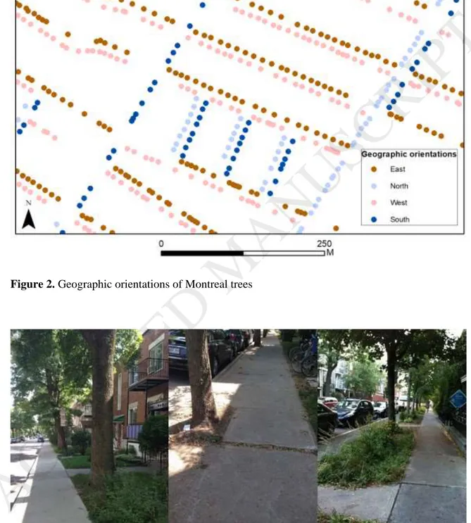
The so-called physical variables of the tree are the variables linked to the type of planting: that is, the geographic orientation, type of location, and presence of an obstruction (these qualitative variables are listed in Table 2). The geographic orientation of the tree refers to its position in relation to the street, i.e. north side, south side, east side, or west side which are defined by the city according to the north of Montreal and not the geographical north (Figure 2). On streets that go along the north-south direction, trees are planted along the east-west direction. Along with the height of the buildings and the width of the streets, the orientation has an impact on tree growth in connection with the amount of light received (K. Logan, 1-16., 1965) and hydric stress linked to sun exposure (Whitlow et al., 1992). The west is the reference.
<< Figure 2 >>
Types of location were grouped into five categories as follows: border (space between the building and the sidewalk), sidewalk cutout, sidewalk planting strip (continuous alignment between the sidewalk and the curb), park (near the sidewalk running alongside parks), and other (green island, terrace, curb extension) (Figure 3). Most of the trees are planted on borders and in sidewalk cutouts (96.1%) (Table 2). The other category is the reference variable.
<< Figure 3 >>
The twenty-eight types of obstructions were also grouped into six categories as follows: wire, street lamp, building, signage, tree, and other (protective arch, balcony, fire hydrant, fence, underground pipes, etc.). More than 50% of the trees do not have any obstructions, and 27.7% are near wires (Table 2). The building category is the reference variable.
Independent variables – Level 2: Characteristics of the street section
The second level consists of 13 variables associated with the characteristics of the street section, the characteristics of the buildings, and land use types. The characteristics of the street include three variables: the street width, length, and setback. The building characteristics consist of six variables: the median age of the buildings, the percentage of duplexes, triplexes, multi-unit dwellings and single-family homes, and the number of housing units. Land use types include four variables: residential, commercial, industrial, and mixed (residential and commercial) zoning (Table 3).
Independent variables – Level 3: Characteristics of the census tract
The third level, represented by the census tract, consists of five socio-demographic variables: the percentage of recent immigrants, the percentage of renters, the percentage of households with children, the percentage of university graduates, and the housing value (Table 3). These variables were chosen based on the literature on urban vegetation, and especially the theories of social stratification and lifestyle (see also Table 1).
<<Table 3>>
Statistical models: Multilevel analysis
In our models, two types of effects are analyzed with the multilevel model: that is, fixed effects and random effects. We allow all the independent variables to have fixed effects. We allow the intercept to vary randomly on the level of the streets and census tracts, which means that the intercept of the models changes from one street to another and from one tract to another, in order to capture the fact that some variables that influence the growth may be missing. This then enables us to obtain more robust results. Since the last model contains 24 variables nested into three levels, we do not allow the independent variables to vary randomly because this implies adding pairs of interactions of variables and could make the models very complex. The variance inflation factor (VIF) had been calculated earlier in order to ensure that there was no excessive
multicollinearity between the independent variables, i.e. VIF should be lower than 5 (Chatterjee & Hadi, 2006). Our VIF values vary from 1.00 to 4.05.
To quantify the relative importance of the levels of analysis (i.e. the variance of tree growth attributed to each level of analysis), we conduct statistical models in four stages by using four models. Model 1 does not have any independent variable, but only the constant. This allows us to quantify the variation in the growth across the census tracts. Model 2 contains the biological and physical characteristics of the tree (Level 1). The characteristics of the street sections (Level 2) are added in Model 3, and the characteristics of the population (Level 3) are added in Model 4. Using covariance estimates produced by the four models, we compute two intraclass correlation coefficients (ICC). ICCs are calculated in equations 5 and 6 (adapted from Bell et al. (2013)): ICCstreet = σ2street / ( σ2e + σ2street + σ2CT ) (5)
ICCCT = σ2CT / ( σ2e + σ2street + σ2CT ) (6)
Where ICCstreet and ICCCT are the ICC at the street and census tract levels, respectively. σ2e is a covariance estimate for the residuals (at the tree level), σ2street is a covariance estimate for the street intercept, and σ2
CT is a covariance estimate for the census-tract intercept. These estimates are produced by Model 1.
ICCstreet indicates similarity (correlation) of the growth between trees on the same street (within the same census tract), or, alternatively, ICCstreet informs the total variation of the growth existing between streets. ICCCT indicates similarity between streets in the same census tracts.
We compare the model fit by using the Akaike information criterion (AIC) produced in each model. Smaller values represent better fitting models. All the models were conducted in SAS 9-4 software with the Proc Mixed procedure. Models were fitted using maximum likelihood
estimation. Results
Variance of tree growth attributed to each level
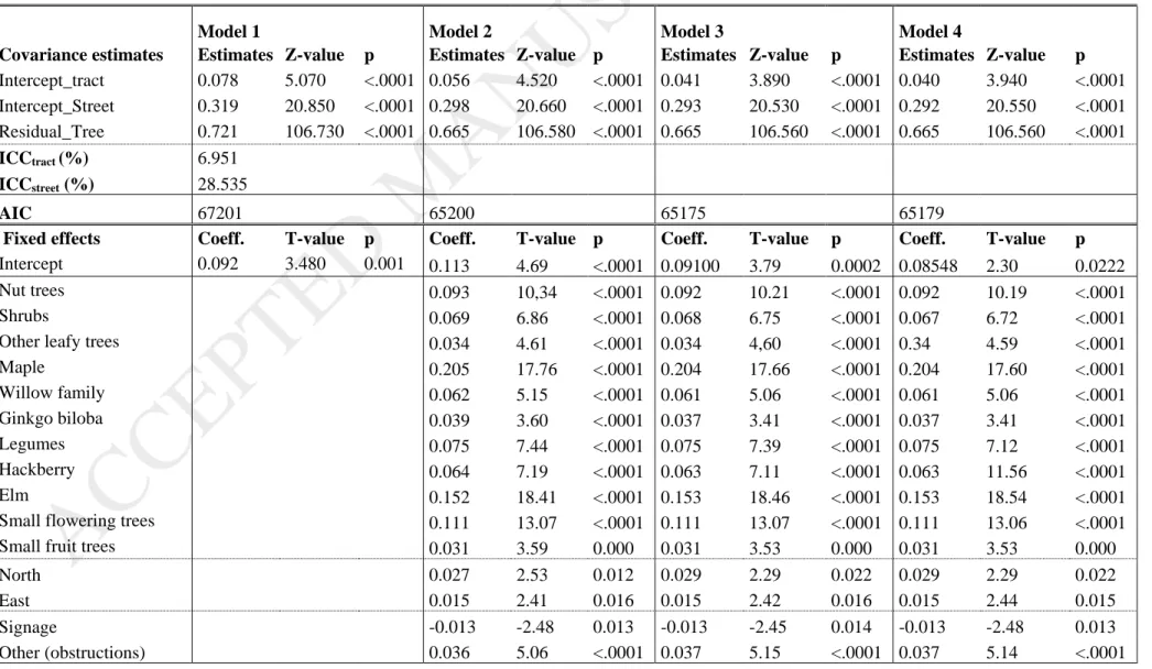
AICs’ results (67201, 65200, 65175 and 65179 across the four models) show a drastic reduction in the AIC in Model 2 compared with Model 1 (Table 4). The introduction of the biological and physical variables of the tree in Model 2 (age, species, geographic orientation, type of location, and presence of an obstruction) is therefore very important and largely helps to explain the variance of tree growth. This is confirmed by ICCs also. However, adding socio-ecomonimc
variables do not help improve the estimation (model 4 having a slightly higher AIC than model 3).
<<Table 4>>
ICCstreet shows 28.54% between similarty of tree growth between streets, or in other words all variables at the street level can potentially explain up to 28.54% of the total variation of tree growth. ICCtract indicates 6.95% of similarity of tree growth between census tracts, suggesting that socio-potical variables operating at the tract level can only explain a very minor part of the variance of tree growth. Adding these two numbers, we get 35.49% of similarity of tree growth at these two levels. Therefore, the majority (65.51%) of the variation in the growth is due to the characteristics of the trees. This is confirmed by changes of variances across the four models. Adding the tree variables (in Model 2) helps reduce variances on the three levels, but adding the street variables (in Model 3) helps reduce only slightly variances at the street and tract levels (from 0.298 to 0.293 and from 0.056 to 0.041, respectively). Adding the tract variables (model 4) brings almost no change in the varialce at the street and tract levels.
Fixed effects at the three levels
The coefficients relating to the species, geographic orientation, types of location and presence of an obstruction remain largely the same in all models. We interpret those produced by Model 4. At level 1, species groups are significantly associated with the growth, except for the category of the conifer and willow family (having linden as the reference). All the significant coefficients are positive, except ash. This result suggests all the specicies tend to grow faster than linden, except
ash growing more slowly, while confiner and willow are not significant. The species that has the
biggest association with tree growth is maple, and the one that has the smallest association is
gingko.
As for the trees’ geographic orientation, compared with the west side, which is the reference variable, the north side (coefficient of 0.029 with p<0.022) and the east side (coefficient of 0.015 with p<0.015) have positive and significant associations with the growth. Trees found on the north and east side grow faster than those on the west side. As for the trees’ location, none of the
variables is significant when the other category is the reference. Concerning the presence of an obstruction, signage (-0.013, with p<0.013) are significantly and negatively associated with the growth, while other (0.037, with p<.0001) is significantly and positively associated, compared with building which is the reference variable.
Regarding the fixed effects of Level 2 (the street section), only four variables are significant: median age of buildings (-0.158 with p< 0.008), its squared terms (0.187 with p<0.002), mixed zoning (-0.032 with p<0.043) and residential zoning is (0.034 with p<0.06). The other variables relating to the characteristics of the street section (street width, street length, types of buildings, commercial and industrial zoning, the number of housing units and setback) are not significant. This confirms what we observed above from AIC values that urban form has little association with the variance of the explained growth.
At Level 3, the socio-demographic variables are not significant at all, confirming what are observed at ICC and AIC values above. However, it is worth noting that omitting variables at the tract level that can explain 6.95% of the variance (as shown in ICCtract).
Discussions
Comparing the explanatory power of the levels
Our model results suggest the variables characterizing the tree and its place of planting are the most important for street tree growth, followed by the variables characterizing the street. Our coefficients show that when we take into consideration these two groups of variables, the socio-demographic variables are not significant. But our ICC values indicate other variables that are missing in this study can explain up to 6.95% of the variance of tree growth. This may be explained by the fact that the social context has little impact or no impact on municipally managed trees such as street trees in our case. Studies that demonstrate the impact of
socioeconomic variables on urban vegetation cover pertain mostly on privately managed trees such as in residential land (Grove et al., 2006; Lowry, Baker, & Ramsey, 2012; Troy et al., 2007). In sum, the order of importance of the groups is in line with the findings of several authors who have affirmed the predominant role of biophysical variables and urban form (Bigsby et al., 2013; Nowak et al., 1996; Pham et al., 2017) over socioeconomic variables.
Level 1: Biological and physical variables
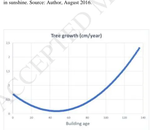
The east and north sides (geographic orientation of the trees) are positively correlated with the growth. Montreal’s street network seems to favour trees planted on the east and west sides (Figure 4) which, combined with the street width, building height and tree height, allows trees to benefit from a combination of sunshine encouraging photosynthesis (O'Rourke & Terjung, 1981; Takagi & Gyokusen, 2004) and shade reducing hydric stress (Whitlow et al., 1992).
<<Figure 4>>
Concerning the presence of an obstruction, the negative association of signage can be explained by the fact that these objects introduce important obstructions in the air above trees (compared to
building). Studies shown that obstructions in the air that necessitate pruning reduce the volume of
the crown and thus the photosynthesis needed for trees to grow (Nowak et al., 1990). What is surprising is that the other category of obstructions has a positive association with tree growth. Since we do not have detailed description of this category we are not able to explain this association.
Level 2: Urban form variables
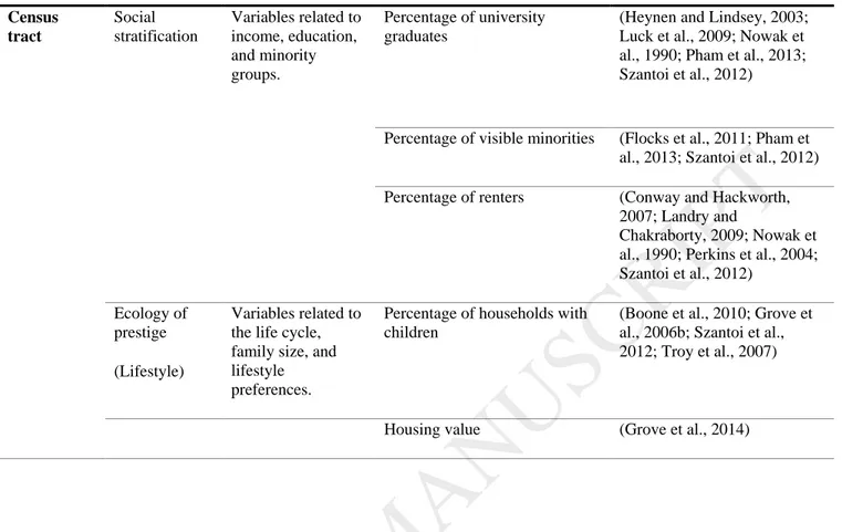
The associations of the building age and its squared terms suggest a non-linear relationship between building age and tree growth. To illustrate this relationship, we compute the tree growth variable by varying building age from 1 to 136 (which is its maximum in this database). Building age and its squared term are converted into their standardized values. Other significant
standardized variables are fixed at 0.1 which is equal 0.1 standard deviation (from their mean value). Standardized tree growth is then computed using coefficients produced by Model 4 and finally multipled by its standard deviation to get its real unit (cm/year). In Figure 5 the
relationship between buildinage age and street tree growth in our study is represented by a convexe curve. On streets having buildings aged from 1 to 47 years the older the buildings are, the smaller tree growth is. But on streets having buildings over than 48 years, the older the buildings are, the bigger tree growth is. This relationship is inverse of the relationship between tree cover and neighbourhood age that are documented in previsous studies (e.g. Mennis, 2006; Pham et al., 2013).
<<Figure 5>>
Mixed zoning combines residential and commercial zoning. In general, the mixed zones analyzed have a combination of commercial uses on the ground floor and residential uses on upper floors.
The negative correlation may therefore be due to activities associated with commercial zoning: that is, more intense activity around trees (busy automobile and pedestrian traffic) and a higher risk of damage linked to denser circulation and vandalism (as shown in the Montreal photos in Figure 6). Trees also suffer more hydric stress and soil compaction, variables that increase the mortality rate of trees, in commercial areas (Nowak et al., 2004).
<<Figure 6>>
Conclusion
On the methodological level, this study shows that the use of variables associated with the canopy and the survival and mortality rates of trees to identify associations with tree growth is justified and reliable. In addition, multilevel analysis is a practical way of revealing the explanatory power of each level. The introduction of random effects demonstrates that the role of biological and physical variables varies across street sections, and, similarly, across census tracts. The results of the analyses suggest that the planting and management of urban trees should take the urban form around trees into account. Overall, the multilevel analysis and random effects ensure the
robustness of the results.
Some limitations should be noted with this study. First, the data does not include the pit size which is noted in the literature as an important factors tree growth. Second, the tree inventory contains a number of errors, which include the lack of a planting date for several trees. It may be that these are the oldest trees and that our database is not representative of street trees in
Montreal. Third, we are not able to include all species, so that we have to group them and we may not have captured certain nuances in the association of the species on tree growth. Finally,
random effects of the independent variables, interactions between variables across levels and spatial autocorrelations are not tested. This is because our models containing three levels and include 24 variables, we decided not to make the model too complex.
Our results suggest some potential recommendations that may be useful for practitioners. The impact of the variables that are negatively associated with tree growth may be reduced if we try to create other conditions that are favourable for trees to grow. For example, when planting on streets having a mixed function and recent buildings, one should encourage maximum tree growth by giving the trees more space (planting in borders, for example), add soil pit protection to prevent trampling and avoiding obstructions.
References
Agriculture et Agroalimentaire Canada. (2013). Integrated Taxonomic Information System (ITIS). Retrieved from: http://www.itis.gov/
Bell, B. A., Ene, M., Smiley, W., & Shonenberger, J. A. (2013, April 28 - May 1). A multilevel
primer using SAS ® PROC MIXED. Paper presented at the SAS Global Forum 2013
Proceedings, San Francisco.
Bigsby, K., McHale, M., & Hess, G. (2013). Urban Morphology Drives the Homogenization of Tree Cover in Baltimore, MD, and Raleigh, NC. Ecosystems, 1-16. doi:10.1007/s10021-013-9718-4
Boone, C. G., Cadenasso, M. L., Grove, J. M., Schwarz, K., & Buckley, G. L. (2010). Landscape, vegetation characteristics, and group identity in an urban and suburban watershed: why the 60s matter. Urban Ecosystems, 13, 255-271.
Brouillet, L., F. Coursol, S.J. Meades, M. Favreau, M. Anions, Bélisle, P., & Desmet, P. (2010).
VASCAN, the Database of Vascular Plants of Canad. Retrieved from:
http://data.canadensys.net/vascan/search
Chatterjee, S., & Hadi, A. (2006). Regression Analysis by Example (4th Edition ed.). New York: John Wiley and Sons.
City of Montréal. (2011). Plan d'action de canopé 2012-2021. Montréal.
Clark, J. R., Matheny, N. P., Cross, G., & Wake, V. (1997). A model of urban forest sustainability.
Journal of Arboriculture, 23, 17-30.
Conway, T., & Hackworth, J. (2007). Urban pattern and land cover variation in the greater Toronto area. The Canadian Geographer / Le Géographe canadien, 51(1), 43-57. de Vries, S., van Dillen, S. M. E., Groenewegen, P. P., & Spreeuwenberg, P. (2013). Streetscape
greenery and health: Stress, social cohesion and physical activity as mediators. Social
Science & Medicine, 94, 26-33. doi:http://dx.doi.org/10.1016/j.socscimed.2013.06.030
Foster, R. S., & Blaine, J. (1978). Urban tree survival: Trees in the sidewalk. Journal of
Arboriculture, 4(14-17).
Gillespie, T. W., Pincetl, S., Brossard, S., Smith, J., Saatchi, S., Pataki, D., & Saphores, J.-D. (2011). A time series of urban forestry in Los Angeles. Urban Ecosystems, 15(1), 233-246. doi:10.1007/s11252-011-0183-6
Grabosky, J., & Gilman, E. (2004). Measurement and prediction of tree growth reduction from tree planting space design in established parking lots. Journal of Arboriculture, 30(3), 154-164.
Grove, J. M., Locke, D. H., & O'Neil-Dunne, J. P. (2014). An ecology of prestige in New York City: examining the relationships among population density, socio-economic status, group identity, and residential canopy cover. Environ Manage, 54(3), 402-419.
doi:10.1007/s00267-014-0310-2
Grove, J. M., Troy, A., O'Neil-Dunne, J. P. M., Burch, W. R., Cadenasso, M. L., & Pickett, S. T. A. (2006). Characterization of households and its implications for the vegetation of urban ecosystems. Ecosystems, 9, 578-597.
Heynen, N., & Lindsey, G. (2003). Correlates of urban forest canopy cover: Implications for local public works. Public Works Management & Policy, 8(1), 33-47.
doi:10.1177/1087724x03008001004
Hubacek, K., & Kronenberg, J. (2013). Synthesizing different perspectives on the value of urban ecosystem services. Landscape and Urban Planning, 109(1), 1-6.
doi:http://dx.doi.org/10.1016/j.landurbplan.2012.10.010
Impens, R. A., & Delcarte, E. (1979). Survey of urban trees in Brussels, Belgium. Journal of
Arboriculture, 5(8), 169-175.
Jim, C. Y. (1987). The status and prospects of urban trees in Hong Kong. Landscape and Urban
Planning, 14, 1-20. doi:http://dx.doi.org/10.1016/0169-2046(87)90002-8
Koeser, A., Hauer, R., Norris, K., & Krouse, R. (2013). Factors influencing long-term street tree survival in Milwaukee, WI, USA. Urban Forestry & Urban Greening, 12(4), 562-568. doi:10.1016/j.ufug.2013.05.006
Landry, S. M., & Chakraborty, J. (2009). Street trees and equity: evaluation the spatial distribution of an urban amenity. Environment and Planning A, 41, 2651-2670. Lawrence, A. B., Escobedo, F. J., Staudhammer, C. L., & Zipperer, W. (2012). Analyzing growth
and mortality in a subtropical urban forest ecosystem. Landscape and Urban Planning,
104(1), 85-94. doi:10.1016/j.landurbplan.2011.10.004
Lesser, L. M. (1996). Street tree diversity and DHB in southern California. Journal of
Arboriculture, 22(4), 180-186.
Liu, J., Daily, G. C., Ehrlich, P. R., & Luck, G. (2003). Effects of household dynamics on resource consumption and biodiversity. Letters to nature, 421, 530-533.
Locke, D. H., Landry, S. M., Grove, J. M., & Roy Chowdhury, R. (2016). What’s scale got to do with it? Models for urban tree canopy. Journal of Urban Ecology, 2(1), juw006. doi:10.1093/jue/juw006
Logan, J. R., & Molotch, H. (1987). Urban fortunes: The political economy of place. Los Angeles: University of California Press.
Logan, K., 1-16. (1965). Growth of tree seedlings as affected by light intensity. Retrieved from Ottawa:
Lowry, J. H., Baker, M. E., & Ramsey, R. D. (2012). Determinants of urban tree canopy in residential neighborhoods: Household characteristics, urban form, and the geophysical landscape. Urban Ecosystems, 15(1), 247-266. doi:10.1007/s11252-011-0185-4
Lu, J. W. T., Svendsen, E. S., Campbell, L. K., Greenfeld, J., Braden, J., King, K. L., & Falxa-Raymond, N. (2010). Biological, social and urban design factors affecting young street tree mortality in New York City. Cities and the Environment, 3(1), 1-15.
McPherson, E. G., Simpson, J. R., Xiao, Q., & Wu, C. (2011). Million trees Los Angeles canopy cover and benefit assessment. Landscape and Urban Planning, 99(1), 40-50.
doi:http://dx.doi.org/10.1016/j.landurbplan.2010.08.011
Mennis, J. (2006). Socioeconomic-vegetation relationships in urban, residential land: The case of Denver, Colorado. Photogrammetric Engineering & Remote Sensing, 72(8), 911-921. Miller, R. H., & Miller, R. W. (1991). Planting survival of selected street tree taxa. Journal of
Arboriculture, 17(7), 185-191.
Moll, C. W. (1989). The state of our urban forest. American Forests, 95, 61-64.
Morani, A., Nowak, D. J., Hirabayashi, S., & Calfapietra, C. (2011). How to select the best tree planting locations to enhance air pollution removal in the MillionTreesNYC initiative.
Environmental Pollution, 159(5), 1040-1047.
doi:http://dx.doi.org/10.1016/j.envpol.2010.11.022
Mullaney, J., Lucke, T., & Trueman, S. J. (2015). A review of benefits and challenges in growing street trees in paved urban environments. Landscape and Urban Planning, 134, 157-166. doi:http://dx.doi.org/10.1016/j.landurbplan.2014.10.013
Nielsen, C. N., Bühler, O., & Kristoffersen, P. (2007). Soil water dynamics and growth of street and park trees. Arboriculture & Urban Forestry, 33(4), 231-245.
Nowak, D. J., Crane, D. E., & Stevens, J. C. (2006). Air pollution removal by urban trees and shrubs in the United States. Urban Forestry & Urban Greening, 4(3–4), 115-123. doi:10.1016/j.ufug.2006.01.007
Nowak, D. J., Kuroda, M., & Crane, D. E. (2004). Tree mortality rates and tree population projections in Baltimore, Maryland, USA. Urban Forestry & Urban Greening, 2(3), 139-147. doi:10.1078/1618-8667-00030
Nowak, D. J., McBride, J. R., & Beatty, R. A. (1990). Newly planted street tree growth and mortality. Journal of Arboriculture, 16(5), 124-129.
Nowak, D. J., Rowntree, R. A., McPherson, G., Sisinni, S. M., Kerkmann, E. R., & Stevens, J. C. (1996). Measuring and analyzing urban tree cover. Landscape and Urban Planning, 36, 49-57.
O'Rourke, P. A., & Terjung, W. H. (1981). Relative influence of city structure on canopy photosynthesis. Int J Biometeorol, 25(1), 1-19.
Pauleit, S., Jones, N., Garcia-Martin, G., Garcia-Valdecantos, J. L., Rivière, L. M., Vidal-Beaudet, L., . . . Randrup, T. B. (2002). Tree establishment practice in towns and cities – Results from a European survey. Urban Forestry & Urban Greening, 1(2), 83-96. doi:10.1078/1618-8667-00009
Pham, T.-T.-H., Apparicio, P., Landry, S., Séguin, A.-M., & Gagnon, M. (2013). Predictors of the distribution of street and backyard vegetation in Montreal, Canada. Urban Forestry &
Urban Greening, 12(1), 18-27. doi:10.1016/j.ufug.2012.09.002
Pham, T.-T.-H., Apparicio, P., Séguin, A.-M., & Gagnon, M. (2011). Mapping the greenscape and environmental equity in Montreal: An application of remote sensing and GIS. In S. Caquard, L. Vaughan, & W. Cartwright (Eds.), Mapping Environmental Issues in the City:
Arts and Cartography Cross Perspectives (pp. 30-48): Springer: Lecture Notes in
Geoinformation and Cartography.
Pham, T.-T.-H., Philippe, A., Landry, S., & Lewnard, J. (2017). Disentangling the effects of urban form and socio-demographic context on street tree cover: A multi-level analysis from Montréal. Landscape and Urban Planning, 157, 422-433.
doi:10.1016/j.landurbplan.2016.09.001
Quigley, M. F. (2004). Street trees and rural conspecifics: Will long-lived trees reach full siza in urban conditions? Urban Ecosystems, 7, 29-39.
Richardson, E., & Shackleton, C. M. (2014). The extent and perceptions of vandalism as a cause of street tree damage in small towns in the Eastern Cape, South Africa. Urban Forestry &
Urban Greening, 13(3), 425-432. doi:10.1016/j.ufug.2014.04.003
Roman, L. A., Battles, J. J., & McBride, J. R. (2014). The balance of planting and mortality in a street tree population. Urban Ecosystems, 17(2), 387-404. doi:10.1007/s11252-013-0320-5
Roman, L. A., & Scatena, F. N. (2011). Street tree survival rates: Meta-analysis of previous studies and application to a field survey in Philadelphia, PA, USA. Urban Forestry &
Urban Greening, 10(4), 269-274. doi:10.1016/j.ufug.2011.05.008
Roy, S., Byrne, J., & Pickering, C. (2012). A systematic quantitative review of urban tree benefits, costs, and assessment methods across cities in different climatic zones. Urban Forestry
& Urban Greening, 11(4), 351-363. doi:http://dx.doi.org/10.1016/j.ufug.2012.06.006
Sanders, R. A. (1984). Some determinants of urban forest structure. Urban Ecology, 8(1), 13-27. doi:http://dx.doi.org/10.1016/0304-4009(84)90004-4
Statistics Canada. (2006). 2006 Census Dictionary. Ottawa Retrieved from
http://www12.statcan.gc.ca/census-recensement/2006/ref/dict/pdf/92-566-eng.pdf. Stoffberg, G. H., van Rooyen, M. W., van der Linde, M. J., & Groeneveld, H. T. (2008). Predicting
the growth in tree height and crown size of three street tree species in the City of Tshwane, South Africa. Urban Forestry & Urban Greening, 7(4), 259-264.
doi:10.1016/j.ufug.2008.05.002
Takagi, M., & Gyokusen, K. (2004). Light and atmospheric pollution affect photosynthesis of street trees in urban environments. Urban Forestry & Urban Greening, 2(3), 167-171. doi:10.1078/1618-8667-00033
Tooke, T. R., Klinkenberg, B., & Coops, N. C. (2010). A geographical approach to identifying vegetation-related environmental equity in Canadian cities. Environment and Planning
B: Planning and Design, 37, 1040-1056.
Troy, A., Grove, J. M., O'Neil-Dunne, J. P. M., Pickett, S. T. A., & Cadenasso, M. L. (2007).
Predicting opportunities for greening and patterns of vegetation on private urban lands.
Environ Manage, 40, 394-412.
Whitlow, T. H., Bassuk, N. L., & Reichert, D. L. (1992). A 3 year study of water relations of urban street trees. Journal of Applied Ecology, 29(2), 436-450.
Figure 1. City of Montreal before the 2002 mergers, and its boroughs
Figure 2. Geographic orientations of Montreal trees
Figure 3. Three of the most common types of location: border (left), sidewalk cutout (centre), and sidewalk planting strip (right). Source: Authors, August 2016.
Figure 4. Left: Trees situated to the south in sunshine. Right: Trees situated to the east and west in sunshine. Source: Author, August 2016.
Figure 5. Simulated relationship between building age and the tree growth
Figure 6. Examples of vandalism. Source: Author, August 2016.
Table 1. Summary of variables used in earlier studies
Scale of Analysis
Theories Variables Variables Used Authors
Street section
Population density
Inhab./km2 - Number of housing units
- Number of inhabitants per square kilometre
(Cook et al., 2012; Grove et al., 2006b; Nowak et al., 1990)
Urban form Characteristics of the streets,
buildings, and types of zoning.
Street length and width (Dobbs et al., 2013; Lu et al., 2010)
Median age of buildings (Bigsby et al., 2014; Grove et al., 2006b; Heynen and Lindsey, 2003) Percentages of single-family
homes, duplexes, triplexes, multi-unit dwellings
(Nowak et al., 1990)
Percentage of residential, mixed (commercial and residential), commercial, and industrial zoning
(Conway and Hackworth, 2007; Lu et al., 2010; Nowak et al., 2004, 1996)
Census tract Social stratification Variables related to income, education, and minority groups. Percentage of university graduates
(Heynen and Lindsey, 2003; Luck et al., 2009; Nowak et al., 1990; Pham et al., 2013; Szantoi et al., 2012)
Percentage of visible minorities (Flocks et al., 2011; Pham et al., 2013; Szantoi et al., 2012) Percentage of renters (Conway and Hackworth,
2007; Landry and
Chakraborty, 2009; Nowak et al., 1990; Perkins et al., 2004; Szantoi et al., 2012)
Ecology of prestige (Lifestyle)
Variables related to the life cycle, family size, and lifestyle preferences.
Percentage of households with children
(Boone et al., 2010; Grove et al., 2006b; Szantoi et al., 2012; Troy et al., 2007)
Housing value (Grove et al., 2014)
Table 2. Description of the qualitative variables on the level of the trees. The reference categories in the regressions are marked “ref” in this table.
Qualitative Variables (Level 1) % of Trees Average growth (cm/year)
Species Nut trees 2.22 Shrubs 0.23 Other leafy trees 0.40
Conifers 0.25 Maple 31.29 Birch family 0.06 Willow family 0.35 Ash 31.99 Ginkgo biloba 0.63 Legumes 7.25 Hackberry 3.03 Elm 2.66
Small flowering trees 2.62 Small fruit trees 3.87
Linden (ref) 13.15
Orientation North 12.03
South 11.50
East 39.15
West (ref) 37.32
Location Border (ref) 56.50 Sidewalk cutout 39.50
Table 3. Descriptive statistics of variables before standardization (without qualitative variables such as groups of species, types of location, types of obstructions, and geographic orientations).
Sidewalk planting strip 3.22
Park 0.42
Other 0.36
Obstructions Wire (ref) 0.28
Street lamp 7.87
Building 5.08
Signage 1.78
Tree 1.07
Other 3.30
Variables (Unit) Min. Max. Mean Standard
Deviation Dependent variable n=27,889 Growth (cm/year) 0.10 29.00 1.37 0.77 Level 2 Street section (n= 2,728) Street width (m) 1.00 114.62 14.11 6.51 Street length (m) 1.00 606.45 185.52 108.17 Median age of buildings 2.00 136.00 56.35 22.69 Single-family (%) 0.00 100.00 22.28 33.27 Duplex (%) 0.00 100.00 31.78 29.43 Triplex (%) 0.00 100.00 20.64 23.25 Multi-unit dwelling (%) 0.00 100.00 25.31 30.65 Residential (%) 0.05 100.00 83.48 26.02 Commercial (%) 0.00 95.08 0.12 2.96 Mixed (%) 0.00 92.39 4.63 12.11 Industrial (%) 0.00 92.96 0.34 4.47 Number of housing units 1.00 117.00 28.73 19.02
Setback (m) 0.00 32.25 6.59 3.04
Level 3 Census tract
(n=234)
Recent immigrants (%) 12.00 1.00 35.00 7.00 Households with children (%) 33.00 7.00 65.00 11.00 Renters (%) 69.00 10.00 96.00 12.00 Housing value ($) 263,000 148,000 793,000 49.00 Univ. graduates (%) 18.00 3.00 46.00 8.00
Distribution of units per cluster
Number of trees per street 1.00 231.00 11.96 13.73 Number of streets per census tract 1.00 840.00 125.54 148.15
Table 4. Multilevel results (only the significant variables are presented). See Table 2 for the reference categories.
Model 1 Model 2 Model 3 Model 4
Covariance estimates Estimates Z-value p Estimates Z-value p Estimates Z-value p Estimates Z-value p Intercept_tract 0.078 5.070 <.0001 0.056 4.520 <.0001 0.041 3.890 <.0001 0.040 3.940 <.0001 Intercept_Street 0.319 20.850 <.0001 0.298 20.660 <.0001 0.293 20.530 <.0001 0.292 20.550 <.0001 Residual_Tree 0.721 106.730 <.0001 0.665 106.580 <.0001 0.665 106.560 <.0001 0.665 106.560 <.0001 ICCtract (%) 6.951 ICCstreet (%) 28.535 AIC 67201 65200 65175 65179
Fixed effects Coeff. T-value p Coeff. T-value p Coeff. T-value p Coeff. T-value p
Intercept 0.092 3.480 0.001 0.113 4.69 <.0001 0.09100 3.79 0.0002 0.08548 2.30 0.0222
Nut trees 0.093 10,34 <.0001 0.092 10.21 <.0001 0.092 10.19 <.0001
Shrubs 0.069 6.86 <.0001 0.068 6.75 <.0001 0.067 6.72 <.0001
Other leafy trees 0.034 4.61 <.0001 0.034 4,60 <.0001 0.34 4.59 <.0001
Maple 0.205 17.76 <.0001 0.204 17.66 <.0001 0.204 17.60 <.0001 Willow family 0.062 5.15 <.0001 0.061 5.06 <.0001 0.061 5.06 <.0001 Ginkgo biloba 0.039 3.60 <.0001 0.037 3.41 <.0001 0.037 3.41 <.0001 Legumes 0.075 7.44 <.0001 0.075 7.39 <.0001 0.075 7.12 <.0001 Hackberry 0.064 7.19 <.0001 0.063 7.11 <.0001 0.063 11.56 <.0001 Elm 0.152 18.41 <.0001 0.153 18.46 <.0001 0.153 18.54 <.0001
Small flowering trees 0.111 13.07 <.0001 0.111 13.07 <.0001 0.111 13.06 <.0001
Small fruit trees 0.031 3.59 0.000 0.031 3.53 0.000 0.031 3.53 0.000
North 0.027 2.53 0.012 0.029 2.29 0.022 0.029 2.29 0.022
East 0.015 2.41 0.016 0.015 2.42 0.016 0.015 2.44 0.015
Signage -0.013 -2.48 0.013 -0.013 -2.45 0.014 -0.013 -2.48 0.013
Other (obstructions) 0.036 5.06 <.0001 0.037 5.15 <.0001 0.037 5.14 <.0001
AgeMed -0.193 -3.38 0.001 -0.158 -2.67 0.008
AgeMed2 0.222 3.95 <.0001 0.187 3.17 0.002
MixPCT -0.031 -1.93 0.054 -0.032 -2.02 0.043
ResiPCT 0.035 1.94 0.052 0.034 1.88 0.060
(Level 1: 27,889 trees, Level 2: 2,728 streets, Level 3: 234 census tract)