HAL Id: tel-03029781
https://hal.archives-ouvertes.fr/tel-03029781
Submitted on 29 Nov 2020HAL is a multi-disciplinary open access archive for the deposit and dissemination of sci-entific research documents, whether they are pub-lished or not. The documents may come from teaching and research institutions in France or abroad, or from public or private research centers.
L’archive ouverte pluridisciplinaire HAL, est destinée au dépôt et à la diffusion de documents scientifiques de niveau recherche, publiés ou non, émanant des établissements d’enseignement et de recherche français ou étrangers, des laboratoires publics ou privés.
based on belief functions
Na Li
To cite this version:
Na Li. Combination of supervised and unsupervised classifiers based on belief functions. Image Processing [eess.IV]. University of Rennes I, 2020. English. �tel-03029781�
Rapporteurs avant soutenance :
Sylvie LE HEGARAT-MASCLE Professeure des universités, Paris-Sud 11
Cédric WEMMERT Professeure des universités, Université de Strasbourg
Composition du Jury :
Président : Sébastien LEFEVRE Professeur des universités, IRISA, Université de Bretagne Sud Examinateurs : Sylvie LE HEGARAT-MASCLE Professeure des universités, Paris-Sud 11
Cédric WEMMERT Professeurdes universités, Université de Strasbourg Zhunga LIU Professeur, Northwestern Polytechnical University, China
Jean DEZERT Senior Research Scientist, DTIS, ONERA
Rémi ESTIVAL Ingénieur de Recherche, Total, Pau
Dir. de thèse : Arnaud MARTIN Professeur des universités, IRISA, Université de Rennes 1
Combination of supervised and unsupervised classifiers based
on belief functions
Thèse présentée et soutenue à Lannion, le 28/09/2020 Unité de recherche : IRISA
Thèse N° : Par
Na LI
T
HESE DE DOCTORAT DE
L'UNIVERSITE
DE
RENNES
1
COMUE UNIVERSITE BRETAGNE LOIRE ECOLE DOCTORALE N°601
Mathématiques et Sciences et Technologies de l'Information et de la Communication Spécialité : Informatique
2.1 A summary of combination methods. . . 40
2.2 Comparison of different uncertainty theories. . . 46
3.1 Spectral bands of RapidEye. . . 68
3.2 Silhouette score of different methods. . . 71
3.3 Relationship among the frames of discernment Ω1, Ω2, Ω3, Ω4 and Ω. . . . 72
3.4 Spectral bands of WorldView-2 . . . 73
3.5 Silhouette score of different methods. . . 75
3.6 Land cover classification scheme of NLCD 2011. . . 77
3.7 Comparison of MLC and MLC + ISODATA in classification accuracy. . . . 82
3.8 Overall accuracy of MLC and MLC+ISODATA with different sizes of train-ing samples. . . 82
3.9 Comparison of SVM and SVM + ISODATA in classification accuracy. . . . 86
3.10 Overall accuracy of SVM and SVM+ISODATA with different sizes of train-ing samples. . . 86
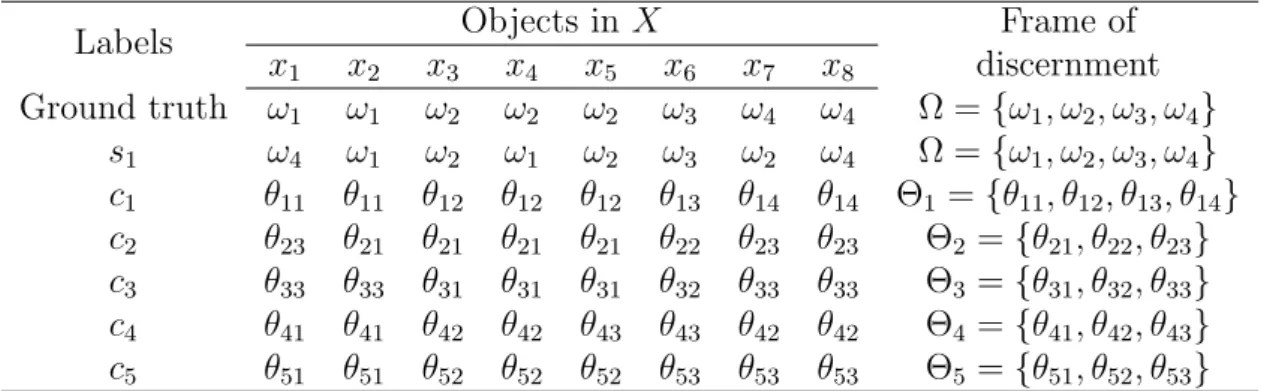
4.1 Labels of ground truth, classification and clustering results on objects in X. 105 4.2 BBAs of classification. . . 106
4.3 Similarity of classes and clusters measured by Jaccard similarity index. . . 106
4.4 Transformed BBAs from clustering c1 on Ω. . . 108
4.5 BBAs on Ω after combination of clustering c1 and classification s1. . . 109
4.6 Decisions on combined BBAs (Compared to the labels and loss of confidence of classification s1). . . 109
4.7 Iterative fusion process. . . 110
4.8 Descriptions of the synthetic ground truth. . . 111
4.9 Combination of one classification and one clustering methods with different likeness/similarity measures. . . 113
4.10 Accuracy of three original classifications and four fusion methods (Karem’s, EFSCmm, EC3, MV) on synthetic data. . . 117
5.1 Descriptions of the test areas. . . 123
5.2 Accuracy of Karem’s, EFSC11 with combination of one classification (5-NN, RF, SGB) and one clustering (KM) for different likeness/similarity measures on test area 1. . . 124
5.3 Accuracy of Karem’s, EFSC11 and EC3, with combination of one classifi-cation (5-NN, RF, SGB) and one clustering (KM, SC,GMM) on test area 1. . . 125 5.4 Accuracy of the original RF, Karem’s EFSC1m and EC3 on test area 1. . . 126 5.5 Descriptions of training samples in the real case (M: proportion of
misla-beled training samples) on test area 1. . . 129 5.6 Accuracy with the mislabeled training samples in the real case on test area 1.129 5.7 Accuracy of the original classifications (5-NN, RF, SGB) and four fusion
methods (Karem’s, EFSCmm, EC3, MV on test area 1. . . 131 5.8 Accuracy of the original classifications (5-NN, RF, SGB) and four fusion
methods (Karem’s, EFSCmm, EC3, MV) on test area 2. . . 134 A.1 Available data in METIS. . . 167
1.1 Overview of the land cover classification scheme. . . 10
1.2 Land cover scheme with multiple refined class types based on environmental and specific technical attributes. . . 11
1.3 Land cover map VS. land use map. . . 12
1.4 Overview of the fusion system. . . 14
1.5 Simplify fusion of land cover maps from multiple sensors as the fusion of land cover maps from multiple classifiers based on multi-spectral data. . . 16
1.6 Model heterogeneity caused by incompatible land cover schemes by fusion of supervised and unsupervised classification methods. . . 17
1.7 The fusion system takes accessibility information as an optional input. . . 18
2.1 Important land cover classification methods in different periods. . . 25
2.2 Relationship of training samples and accuracy for different categories of land cover classification methods. . . 32
2.3 Sequential structure. . . 33
2.4 Parallel structure. . . 34
2.5 General processing steps for different fusion levels. . . 35
2.6 Classification of combination strategies proposed in [57]. . . 38
3.1 Soil line. . . 60
3.2 Threshold of vegetation in NDVI. . . 61
3.3 The scheme of BCI. . . 62
3.4 Principle steps of the proposed automatic water detection method. . . 67
3.5 Original NIR image. . . 68
3.6 Original image in the three dimensional space. . . 68
3.7 Classification results of NIR model and supervised model. . . 69
3.8 Decisions with r = 0.1 and r = 0.9. . . 69
3.9 The relation between r and the percentage of ignorance. . . 70
3.10 BBAs after fusion on each class. . . 70
3.11 Results of k-means and GMM. . . 71
3.12 Work-flow of the automatic land cover identification method. . . 73
3.13 False color composite of WorldView-2 image. . . 74
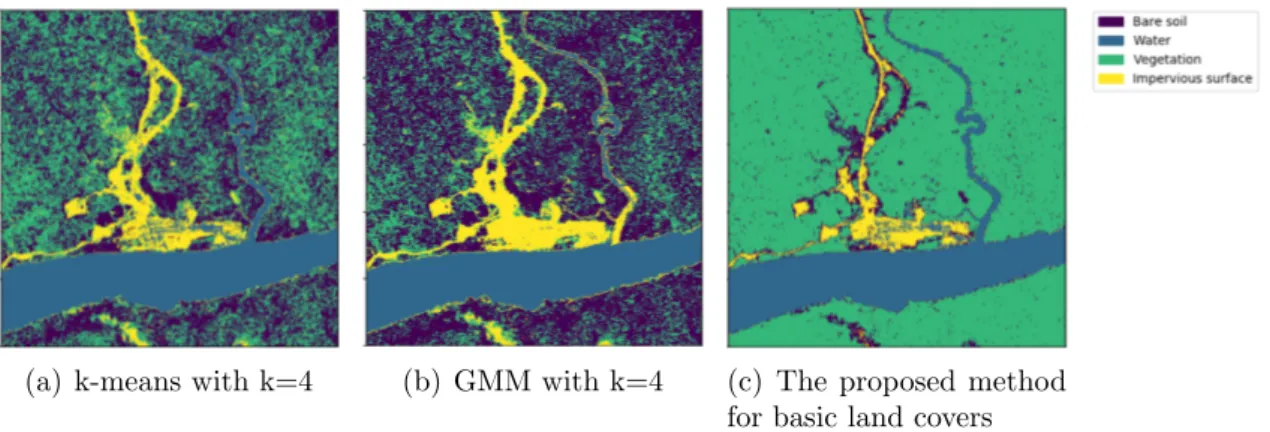
3.14 Results of k-means, GMM and the proposed automatic method for basic land covers. . . 74
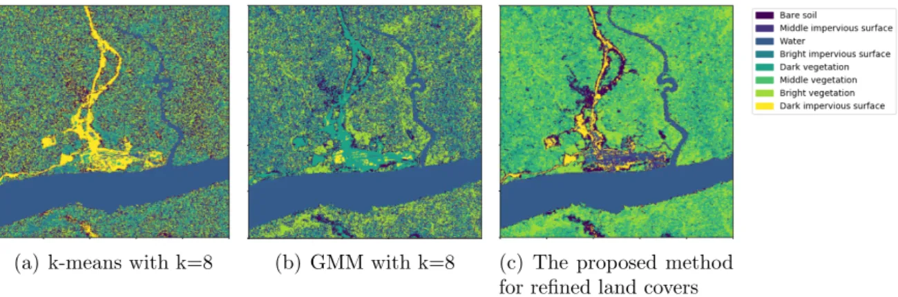
3.15 Results of k-means, GMM and the proposed automatic method for refined
land covers. . . 75
3.16 Map of the study area. . . 77
3.17 The proposed framework based on object association. . . 80
3.18 Comparison of MLC and MLC+ISODADA. . . 83
3.19 Accuracy with different sizes of training samples. . . 83
3.20 Comparison of SVM and SVM+ISODADA. . . 84
3.21 Accuracy with different sizes of training samples. . . 85
4.1 Transformation method to change the BBA in the frame of discernment Θ to Ω. . . 97
4.2 Workflow of the proposed EFSC. . . 103
4.3 Accuracy change with mistakes in clustering for the combination of one classification and one clustering. . . 114
4.4 Accuracy change with mistakes in classification for the combination of one classification and one clustering. . . 114
4.5 Accuracy change with mistakes in clustering for the combination of one classification and multiple clustering methods. . . 115
4.6 Accuracy change with mistakes in classification for the combination of one classification and multiple clustering methods. . . 116
4.7 Synthetic classification results. . . 117
4.8 Combination results of EFSCmm, Karem’s, EC3 and MV on synthetic data.118 5.1 Ground truth of test areas. . . 123
5.2 Accuracy change in the iterative process of EFSC1m and Karem’s on test area 1. . . 127
5.3 Correct objects in different intervals of loss of confidence of EFSC1m and Karem’s on test area 1. . . 128
5.4 Accuracy with different proportions of mislabeled training samples per class in the artificial case on test area 1. . . 130
5.5 Original classification results of 5-NN, RF and SGB on test area 1. . . 131
5.6 Karem’s with combination of one classification (5-NN, RF and SGB) and multiple clustering methods on test area 1 on test area 1. . . 132
5.7 EC3 with combination of one classification (5-NN, RF and SGB) and mul-tiple clustering methods on test area 1. . . 132
5.8 EFSC1m with combination of one classification (5-NN, RF and SGB) and multiple clustering methods on test area 1. . . 133
5.9 EFSCmm, Karem’s and EC3 with combination of multiple classification and clustering methods on test area 1. . . 133
5.10 Original classification results of 5-NN, RF and SGB on test area 2. . . 134
5.11 Combination of multiple classification and clustering by EFSCmm, Karem’s, and EC3, and combination of classifications by MV on test area 2. . . 135
5.12 False composition image of two RapidEye datasets. . . 136
5.13 Automatic land cover maps on RapidEye datasets. . . 137
5.15 Karem’s method on RapidEye datasets. . . 138
5.16 False composition image of two WorldView-2 datasets. . . 139
5.17 Automatic land cover maps on WorldView-2 datasets. . . 140
5.18 EFSC1m, and EFSCmm results on WorldView-2 datasets. . . 141
5.19 Karem’s method on WorldView-2 datasets. . . 141
A.1 The principle of seismic acquisition. . . 164
A.2 Seismic imaging. . . 164
Introduction
Resume
1.1 Introduction . . . 8
1.2 The real-world challenges and limitations . . . 9
1.2.1 Difficulties in labeling process . . . 9
1.2.2 Generation of land use maps by land cover maps . . . 11
1.2.3 Multi-sensor and heterogeneous information fusion . . . 13
1.3 Motivations and contributions . . . 14
1.3.1 Handling limited labeled data . . . 15
1.3.2 Fusion of multiple supervised and unsupervised methods . . . . 15
1.3.3 A fusion architecture possible to define land use maps by users 16 1.3.4 Contributions . . . 17
1.4 Plan of the thesis . . . 18
Land cover classification based on multi-sensor data fusion has great potential for practical applications, especially for missions on complex nature areas. A large number of labeled samples is important in land cover classification. However, collecting sufficient ground information, especially in hard-to-access areas, is usually difficult and expensive. Moreover, labels and remote sensing data are often collected in different periods, so that objects on the ground can be mislabeled. Therefore, our research interest focuses on how to improve the accuracy of land cover classification by fusion of multiple sources when limited labeled samples are available.
In this chapter, we present the challenges and limitations in industrial problems that arose in the METIS (Multiphysics Exploration Technology Integrated System) project initiated by TOTAL. Problems in a natural or industrial context are often difficult to define precisely and clearly. On the contrary, problems in an academic context need to be well described and located. Therefore, the main objective of this chapter is to explain how we transfer multiple industrial requirements into academic problems.
1.1
Introduction
Land cover relates to the biophysical cover of the Earth’s terrestrial surface, identifying vegetation, water, bare soil, or impervious surfaces, etc. Identifying land cover is essential for planning and managing natural resources (e.g. development, protection), understand-ing the distribution of habitats, and for modelunderstand-ing environmental variables. Identification of land cover types provides basic information for the generation of other thematic maps and establishes a baseline for monitoring activities. Therefore, land cover classification using satellite data is one of the most important applications of remote sensing.
A great deal of ground information (e.g. labeled samples) is usually required to gen-erate high-quality land cover classification. However, in complex natural areas, collecting information on the ground can be time-consuming and extremely expensive. Nowadays, multiple sensor technologies have gained great attention in land cover classification. They bring different and complementary information—spectral characteristics that may help to overcome the limitations caused by inadequate ground information. In the METIS project initiated by TOTAL, multiple sensors are available, including sensors for multi-spectral and hyper-multi-spectral imaging, synthetic aperture radar (SAR), and light detection and ranging (LiDAR). Nevertheless, labeled samples in the study area are severely inade-quate. Multiple sensors can generate different land cover maps to provide heterogeneous yet supplementary information of the objects on the ground. Accordingly, in our thesis, we manage to improve the accuracy of land cover classification with limited labeled data by the combination of heterogeneous information from multiple sensors.
Another problem caused by the lack of ground information is the ambiguous relations between land cover maps and land use maps. Land cover maps provide information on natural features that can be directly observed on the Earth’s surface. Land use maps refer to how people are using information on landscapes for different purposes. Without adequate ground information, generating land use maps by land cover maps is difficult for complex areas. For example, in the METIS project, we are interested in a land use map (i.e. accessibility map) to describe the difficulty to move to some location or to traverse some area on the ground. However, the relations between accessibility and land covers are still difficult to determine because the term accessibility involves many factors, such as time, risk, cost etc. Therefore, many ground surveys are required to exploit the real-time information on the ground so that the concept of accessibility can be well-defined in terms of users’ objectives, and that the relations between accessibility and land covers can be determined. Therefore, when combining multiple heterogeneous land cover maps, we have to consider how to enable users to synthesize the scheme for land use maps, such as accessibility with different criteria.
In our research, we focus on the fusion of heterogeneous information from different sources. The combination system aims to solve the problems caused by limited labeled samples and can thus be used in land cover classification for hard-to-access areas. The semantic labels for the land cover classification from each sensor can be different, and may not corresponds to the final scheme of labels that users await. For instance, land cover classification methods of different sensors provide semantic labels for the ground. However, based on these land cover maps, an accessibility map is supposed to be generated to meet users’ needs. Therefore, another objective of the combination is to provide an
interface with a final scheme probably different from the input land cover maps present. In this chapter, we present the challenges and limits of the real problems in section 1.2. In section 1.3, we present our motivations and contributions, focusing on the modeling of these challenges and limitations. We give an overview of this thesis in section 1.4. More details on the METIS project of TOTAL are presented in the appendix A.
1.2
The real-world challenges and limitations
This section explains some major challenges and limitations related to our research in real-world applications. Ground surveys often play an essential role, however, it is usually time-consuming and expensive, sometimes even risky. Limited ground surveys bring many inconveniences, such as difficulties in the labeling process, detailed in section 1.2.1, and problems in land use maps, detailed in section 6.2.4. Besides, fusion of multi-sensor data is also a challenging task in reality because of many factors, such as heterogeneity of data. Related details are presented in section 1.2.3.
1.2.1
Difficulties in labeling process
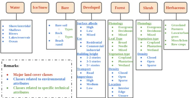
Sufficient labeled data with high quality is one of the prerequisites in land cover classi-fication. Despite various proposed land cover scheme, none of the current schemes has been internationally accepted because the definition of land covers greatly changes due to different purposes. The major process to define land cover scheme includes two phases: an initial dichotomous phase, and a subsequent modular-hierarchical phase, shown in Fig-ure 1.1. In the dichotomous phase, major land cover types (e.g., ice/snow, water, bare) are defined. In modular-hierarchical phase, environmental and technical attributes are incorporated in the definition to refine the major land cover types defined in the dichoto-mous phase. Environmental attributes (e.g., climate, altitude, time, and erosion) easily influence land covers possibly leading to mislabeled. Technical attributes (e.g., floristic aspect, crop types, and soils types) are also sometimes considered in defining land cover types for specific purposes. However, specific technical disciplines are often required dur-ing a ground survey, makdur-ing the labeldur-ing process expensive and time-consumdur-ing. We take a recent land cover scheme proposed by NASA [142] as an example in Figure 1.2. The major land cover classes contain seven types: ice/snow, water, bare, developed, forest, herbaceous, and shrub. Below each of them, more refined class types are defined based on environmental attributes, marked in blue text, and/or specific technical attributes, marked in green text. Some classes related to environmental attributes, such as open shrub and sparse shrub, possibly change in a short time, and their boundaries become less clear to observe on the ground. Furthermore, specific knowledge is required to dis-tinguish phenological sub-classes of forest or shrub, types of bare soil, and rocks.
In multi-sensor systems, data are often collected with different resolutions. Therefore, it is highly possible that the resolution of data required to label does not correspond to the scale of ground survey areas. For example, if the ground survey is conducted by the areas with 30m×30m, collected labels possibly contain information from more than one land covers in each square. Remote sensed data with higher resolution than 30m
Figure 1.1. Overview of the land cover classification scheme.
are easily incorrectly labeled because more detailed information lacks within squares less than 30m×30m. Furthermore, remotely sensed data is also possible to be localized in an incorrect geographic location, especially when the scale of ground survey areas and data resolution is highly different.
Limited accessibility usually occurs in hard-to-access areas such as mountain areas, which makes ground survey extremely difficult. The collection of labeled data in this sit-uation is usually so expensive, risky, and time-consuming that gathering sufficient labeled data is impossible. Besides manually labeling process on the ground, airborne photos and images captured by drones can also help for generating semantic labels. This process, however, is usually expensive in real-life applications, so that is more suitable for labeling simple landscapes such as vegetation area, water, bare soil, etc. More complicated details, related to vegetation type, density, soil humidity, and ground situations, are usually hard to manually describe merely based o airborne photos. It is also highly possible to generate wrong labels in this process.
For some complicated landscapes, the labeling process is usually difficult due to many reasons including but not limited the following:
1) No clear boundary exists between two land cover classes so that they are difficult to distinguish on the ground.
2) Rapid changes of land covers lead to the difference between the ground labels and corresponding remote sensed data.
3) Specific knowledge/techniques are required to distinguish some land cover types on the ground.
Figure 1.2. Land cover scheme with multiple refined class types based on environmental and specific technical attributes.
4) The scale of ground survey areas does not correspond to the resolution of remotely sensed data, especially in multi-sensor applications.
5) Geographic location on the ground does not correspond to the remotely sensed data. 6) Limited accessibility on hard-to-access areas makes the ground survey difficult or
even impossible.
Therefore, collecting sufficient and high quality labeled data is often difficult due to tech-nical or economical limitations. Classification results generated by a limited amount of training data are usually uncertain and incorrect. The limitations caused by insufficient labeled data is one of the major focus of the thesis.
1.2.2
Generation of land use maps by land cover maps
Land use and land cover are two commonly used classification systems describing the circumstance on a given location. Land use and land cover are often confused as in-terchangeable terms in remote sensing applications. However, they describe different characteristics of the landscape and have different usages in reality. Land cover maps provide information on nature features (e.g. vegetation) or man-made constructions (e.g. buildings) that can be directly observed on the Earth’s surface. For example, a land cover map can document how a region is covered by physical land types, including water, forests, wetlands, impervious surfaces, and other land covers. Land use maps refer to how people are using the information on landscapes for different purposes, such as wildlife habitat, conservation, etc. Land use maps do not describe directly the surface cover on the ground whereas they are related to land covers to some extent.
Figure 1.3. Land cover map VS. land use map.
Land cover data usually are interpreted from remote sensing satellite imagery and/or aerial photos because they are merely related to physical characteristics on the surface. Land use data, by contrast, sometimes can be determined from satellite imagery or aerial photos, but not usually. Land use maps often incorporate ancillary data, such as elevation, topographic information, and ground surveys since useful information can be difficult to interpret from imagery, as shown in Figure 1.3.
Classes contained in a land use/land cover map is called as scheme in remote sensing classification, and it also refers to the frame of discernment in belief functions, which are detailed in section 2.4. Each class in the land use/land cover scheme should neither be conflicting nor overlapping in their definitions.
In our research, land cover data are provided by different sensors, such as multi-spectral satellites, SAR or LiDAR, based on which land cover maps can be extracted. However, land use data related to accessibility cannot be directly interpreted by sensors, and even is hard to define by ancillary data.
Determining the accessibility of different land covers is difficult for the following rea-sons:
1) The definition of accessibility is based on multiple criteria and thus could be ambigu-ous or even contradictory sometimes. For example, accessibility can be related to the cost of energy, the consumption of time, the risk of traversing, and the expense of budget.
2) A land cover types may have different accessibility in the same landscape or different ones. For example, grassland on low elevation could be easier to traverse than that on a high elevation.
3) Different land covers could also have the same accessibility in the same landscape or different ones. For example, different vegetation could have the same accessibility
based on energy cost.
Up till now, the definition of accessibility has still been ambiguous and vague, because its determination depends on further observations and surveys on the ground. Therefore, the scheme of land use maps related to the displacement model has not been available. What we can directly obtain from satellites and other sensors is merely the land cover maps. Therefore, to transfer the different land cover maps to the land use map is of great importance.
1.2.3
Multi-sensor and heterogeneous information fusion
The information from different sensors such as multi-spectral satellites, SAR or LiDAR is highly different. It is thus essential to combine heterogeneous information from multiple sensors. Unlike traditional fusion system that is designed to improve the accuracy of land cover classification, besides improvement of accuracy, we also focus on generating land use maps that can be later defined by users. As we presented in section 1.2.1 and 6.2.4, the accessibility is neither well-defined nor used to label data on for a learning process. All information provided by sensors and ground survey is used to generate land cover maps. A clear gap exists between what the users are looking for and what sensors can provide. Therefore, in this thesis, we focus on developing a fusion system which cannot only combine heterogeneous information but also handle the gap, so that land use classes can be defined by users after fusion.
Figure 1.4 describe the overview of the fusion system required in METIS. This fusion system can achieve the combination of data from different sensors and more important, the fusion is supposed to be sensor-independent so that any input sensor can be replaced by others. The processing of data from multiple sensors is extremely different and they are usually managed by different experts separately. Focusing on land cover maps after processing makes the fusion system become sensor-independent and the related details are displayed in section 2.3.
The major difficulties in the fusion system are the fusion of classification maps on dif-ferent land cover schemes into the same scheme. Not all sensors use the same land cover scheme to make their land cover maps. It is thus still possible to have some conflicts in different land cover schemes. Land cover maps, in this case, are also heterogeneous infor-mation. Land use classes, moreover, may be different from any land cover schemes from sensors due to users’ definition. The fusion system has to consider these and meanwhile to handle insufficient and low-quality training samples, as referred in section 1.2.1.
Another difficulty in our research, as we mentioned in section 6.2.4, is the ambigu-ous relations between different land covers and their accessibility. Tracking the problem of accessibility would require lots of ground measurements. Defining, measuring, and processing the accessibility with multiple criteria of land covers is a time and cost con-suming research work. Therefore, as an input of the fusion system, the land use scheme (i.e. accessibility classes) has not been available in our research. This difficulty has been considered in the modeling of real-world problems. Besides, despite the availability of multiple sensors, no ground truth has been available in the study area provided by TO-TAL. Meanwhile, processing techniques of SAR and LiDAR are extremely complicated
Figure 1.4. Overview of the fusion system.
and time-consuming. Due to limited time and energy in our research, we focus more on the architecture of the fusion system rather than processing different data. In our model, data related to multi-sensors is also simplified. Details on how to model the real-world challenges are presented in the following section 1.3.
1.3
Motivations and contributions
This section focuses on modeling the real-world challenges and limitations as research problems. As mentioned in the previous section 1.2, the major problems arrive in our research including:
(1) Only limited and low-quality labeled data are available in the real situation; (2) Complicated and time-consuming processing of data from SAR and LIDAR; (3) Heterogeneity (i.e. using different land cover schemes) of land cover maps make the
fusion difficult;
(4) Concepts and important factors related to accessibility are not available.
In section 1.3.1, we give our proposals to handle the problem (1), we simplify the problem (2) and (3) and formulate a specific research problem in section 1.3.2. The problem (4) is considered in section 1.3.3. In addition, specific academic contributions are detailed in section 1.3.4.
1.3.1
Handling limited labeled data
Limited and low-quality labeled data cause many problems in real applications, which also has a major influence on land cover classification accuracy. Due to many constraints such as economic factors, we can encounter the limited labeled data problem in METIS. Considering the specific context of our research, we propose some directions to compensate for the inconveniences caused by labeled data.
The fusion of multiple land cover maps is an efficient way to improve the overall land cover classification accuracy when each land cover map shows poor performance. Related details about fusion process are presented in the following section 1.3.2 and 1.3.3. It is important to notice that overcoming some limitations from insufficient labeled data and improving accuracy to some extent is one of the benefits provided by fusion processes.
Furthermore, we also consider handling uncertainty and imprecision to generate a soft fusion framework. Uncertainty indicates that some object belongs to certain land cover class with some belief degree. Imprecision describes some objects could belong to the union of two or more land cover class with some belief degree. When lacking sufficient labeled data, we manage to take advantage of information from uncertainty and imprecision. Considering the low accuracy of each land cover map, it is more reasonable not to decide on the label of an object in a crisp way. Therefore, we focus on a soft fusion framework to handle uncertainty and imprecision.
1.3.2
Fusion of multiple supervised and unsupervised methods
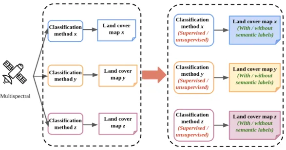
As we mentioned previously, complicated data processing techniques of SAR and Li-DAR and heterogeneity of land cover maps are two major difficulties in reality. In this section, we explain how to simplify and model these difficulties into a specific research problem which becomes the core of our research. The fusion system is supposed to be sensor-independent, which indicates that we focus more on land cover maps from differ-ent sensors instead of data processing and classification methods themselves. Therefore, we use land cover maps generated by different classifiers based on multi-spectral sensors to replace those from multi-sensors, as shown in Figure 1.5. Different sensors capture distinct information on the ground, and have their own data processing techniques, and apply specific classification methods to generate land cover maps. The inputs of the fusion system are different land cover maps instead of initial raw data, intermediate features, or classification methods themselves. That means the fusion system handles directly the high-level information — land cover maps and ignores the low-level information — sensor types, data, features, and classifiers. Accordingly, processes to generate land cover maps by multiple sensors are so complicated yet subordinate that we choose to simplify them as land cover classification by different classifiers based on multi-spectral data.
No matter how we generate different land cover maps, one thing we have to keep in mind is that land cover maps in reality could be incompatible on account of the use of different land cover schemes. In other words, a class defined in one scheme may be conflicting or overlapping with another one in a different scheme. For example, one land cover scheme has Forest, Non-forest as classes; and another scheme includes Vegetation and Non-vegetation. Obviously, a class in one scheme is not the refined class in the other
Figure 1.5. Simplify fusion of land cover maps from multiple sensors as the fusion of land cover maps from multiple classifiers based on multi-spectral data.
one, which brings conflicts. An object belonging to Vegetation could be Forest but also Non-forest. On the contrary, however, an object labeled as Non-forest may belong to Vegetation but could also be Non-Vegetation. Intersections between the two schemes (i.e. Forest, Non-vegetation) are not the refinement of the original classes and they are apparently not exclusive. Accordingly, finding an agreement between these two schemes becomes impossible, which brings a great deal of difficulties to handle heterogeneity in fusion process.
Let us continue with the previous example. Due to conflicts between the two schemes, the semantic meaning of land cover classes in one scheme becomes meaningless for those in the other. We can thus only keep the scheme that we are interested in and consider the other one as a result of clustering, which separates data by their spectral properties yet regardless of semantic labels. In this way, we keep the information that helps to distinguish these land cover classes while ignoring the semantic meaning of labels which brings conflicts with other land cover maps. Therefore, the fusion system focuses on the fusion of multiple supervised and unsupervised classification methods as shown in Figure 1.6, which is also the essence of our research.
1.3.3
A fusion architecture possible to define land use maps by
users
In the previous section 6.2.4, we have presented the gap existing between land cover map and land use map (accessibility map). The inputs of the fusion system are various land cover maps that describe situations on the ground from multiple perspectives. The output for users, however, is supposed to be a land use map that provides information on the accessibility of land covers. The difficulty is that, as we previously mentioned, concepts related to accessibility have still been vague and ambiguous, so that we cannot
Figure 1.6. Model heterogeneity caused by incompatible land cover schemes by fusion of supervised and unsupervised classification methods.
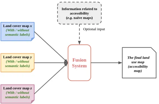
directly use them in our research. Since our major efforts concentrate on the fusion of multiple supervised and unsupervised methods, we have not done deep and far researches on accessibility. Due to the required amount of ground surveys, we leave the related definitions and concepts on accessibility to users. The fusion system, as shown in Figure 1.7, is supposed to take land use maps defined by users as an optional input when it is available.
Land cover maps generated by multiple sensors may have incompatible schemes so that they cannot reach an agreement. What we can do is to keep the schemes we are interested in, and then remove the semantic meanings of land cover classes in those in-compatible ones, that is to say, regarding them as clustering results. When the optional input — accessibility information is available, we can incorporate it into the kept schemes to generate the final accessibility map for users. More details are discussed in chapter 6 on future work.
1.3.4
Contributions
In this section, we briefly resume the major contributions of this dissertation. We classify them according to the area they naturally belong to.
In the area of belief functions, the main contribution is:
• A new methodology to transfer mass functions into another discernment. The main properties of our method that we want to emphasize are the following ones: (i) the transformation can preserve both uncertainty and imprecision from the original frame of discernment and transfer them to the target frame, (ii) the transformation is based on similarity measures, which have multiple choices, (iii) the transformation can also be extended to a learning version, using training samples to learn the similarities.
Figure 1.7. The fusion system takes accessibility information as an optional input.
In the area of fusion of multiple supervised and unsupervised methods, our contribu-tion is:
• A new soft fusion framework based on belief functions that can combine hetero-geneous information and handle uncertainty. Based on the transformation method we proposed, results from either supervised or unsupervised methods can be projected into the discernment that we are interested in. In this framework, we also develop an iterative fusion strategy that helps gradually to reduce uncertainty and make the overall accuracy converge. We evaluate this fusion framework on remote sensing data in land cover classi-fication, and the experiments show its evident efficiency, especially when training samples for supervised methods are insufficient or mislabeled.
In the area of land cover classification, the contribution is:
• A new water detection method based on belief functions. This method takes into account not only decisions on singletons, but also on total ignorance. In this way, potential water on the ground can also be detected.
• An automatic land cover classification method that considers only spectral indexes so that it can directly generate semantic labels without using training samples.
1.4
Plan of the thesis
In this chapter, we have introduced the industrial context of the problems and the diffi-culties of working with real data. We have also explained how to model real tasks into specific research problems. In this dissertation, we essentially focus on the fusion of multi-ple supervised and unsupervised methods and manage to apply the fusion system in land cover classification.
In chapter 2, we present state-of-the-art of the land cover classification using multi-spectral optical data. We review the development of land cover approaches from the 1970s onwards and present the most commonly used methods. More specifically, we discuss their advantages and disadvantages, to localize our proposed frameworks in land cover classification community. We also display a state-of-the-art of fusion techniques at pixel, feature, and decision level, to explain the reason that we focus on the decision level instead of the other two levels. Limited attention has been paid on fusion at the decision level and most common fusion techniques can be separated into two categories: consensus maximization, and uncertainty theories. We briefly present all commonly used approaches based on consensus maximization and the basic concepts of belief functions in this chapter.
In chapter 3, we propose a new water detection method based on belief functions that can make decisions on total ignorance, so that potential water on the ground can also be detected. We also develop an automatic land cover classification method to generate semantic labels without using training samples. Related methods in this chapter show the efficiency and advantages of belief functions in land cover classification.
In chapter 4, we present a new transformation method that can change the discern-ment of mass functions based on similarity measures. The advantages of this architecture include the preservation of both uncertainty and imprecision and multiple choices of sim-ilarity measures. We also propose an iterative fusion strategy for multiple supervised and unsupervised methods, based on the transformation method. We compare the fusion system with this strategy with other state-of-the-art fusion methods at the output level. We evaluate the proposed framework on synthetic data at the output level to study how the quality of supervised and clustering results affect the combination.
In chapter 5, we evaluate the proposed framework on multiple real remote sensing datasets to discuss how limited training samples affect the combination results.
In chapter 6, we give the conclusions of this dissertation and some future research directions related to the problems addressed during this work.
Foundations of land cover
classification and information fusion
Resume
2.1 Introduction . . . 23 2.2 Multi-spectral land cover classification . . . 23 2.2.1 Basic pixel-based methods . . . 25 2.2.2 Subpixel-based methods . . . 27 2.2.3 Contextual-based and object-based methods . . . 28 2.2.4 Deep learning techniques . . . 30 2.2.5 Hybrid/Multiple classifiers system . . . 31 2.3 Information fusion and ensemble methods . . . 32 2.3.1 Structures of fusion . . . 32 2.3.2 Levels of fusion . . . 35 2.3.3 Overview of ensemble methods . . . 37 2.3.4 Semi-supervised ensemble methods at the output level . . . 41 2.4 Theory of belief functions . . . 44 2.4.1 Representation of information . . . 46 2.4.2 Combination and decision . . . 49 2.4.3 Operations over the frame of discernment . . . 51 2.4.4 Refinement and coarsening . . . 51 2.4.5 Marginalization and vacuous extension . . . 52 2.4.6 Transformation with more information . . . 52 2.5 Conclusion . . . 53
Is this thesis, our research focuses on the combination of multiple supervised and unsupervised methods in land cover classification, involving different research domains.
Therefore, in this chapter, we introduce the foundations of the domains related to our re-search, including multi-spectral land cover classification, information fusion and ensemble methods, and the fusion theory we used in our research.
The objective of this chapter is: (1) to understand the trend in land cover classification; (2) to present related researches in information fusion and ensemble methods; (3) to introduce the basic concepts of belief functions; (4) to locate our research topic in the community of land cover classification, ensemble methods and belief functions.
2.1
Introduction
In land cover classification, multiple developments haven been marked in the last four decades. Most classification methods were initially proposed in the 1970s and 1980s. However, many advancements in specific classifiers and algorithms have occurred in the last decade. Supervised and unsupervised pixel-based methods are one of the most im-portant land cover classification methods in the 1970s. After 1980, the augmentation of resolution of remote sensing data makes other methods such as subpixel, contextual-based, and object-contextual-based, and hybrid methods became common in land cover classification. Most studies have reported the superior performance of object-based methods on different landscapes such as urban areas, agricultural areas, and forests. Nevertheless, object-based methods are sensitive to the optimal segmentation scale, which can result in over or under segmentation. The low spatial resolution of images also severely affects the performance of object-based methods. Nowadays, hybrid classifiers and multiple classifier systems have drawn more and more attention in land cover classification.
As multiple classifier systems show great potential in mapping land covers, many information fusion techniques and ensemble learning methods are applied to land cover classification. Therefore, we also give a brief introduction to information fusion techniques, including different structures and levels of fusion, and some popular ensemble methods. According to the needs in METIS, we locate our research interest in semi-supervised learning at the output level. Not too much effort has been paid on this topic according to our knowledge. We present some important previous works to combine supervised and unsupervised classification results at the output level. Most of the current works achieve the combination by maximizing the consensus of all individual classification, which usually requires the baseline with high accuracy. To solve the problems caused by limited training samples, we give a new perspective to solve the combination of supervised and unsupervised classification results in the framework of belief functions. Therefore, we also introduce the basic concepts in this chapter.
In this chapter, we give a brief introduction of multi-spectral land cover classification in section 2.2, information fusion and ensemble methods in section 2.3, and the basic concepts of belief functions in section 2.4. The conclusions are drawn in section 2.5.
2.2
Multi-spectral land cover classification
With the development of land cover classification methods, the accuracy of land cover maps has been greatly improved since the 1970s. It is obvious that classification methods become more and more complicated, and thus relies more on the quality and quantity of training samples. Popular approaches such as multiple classifier systems and deep learning techniques require sufficient and high-quality labeled data to train classifiers. However, collecting labeled data is always an arduous and hazardous task in land cover applica-tions, especially for complex areas such as mountain areas. Therefore, decreasing the requirement of training samples becomes one of the most difficult challenges in land cover classification. Many efforts have been done to solve this problem, yet fewer achievements have recently been reached. Lots of methods are proposed for specific situations, thus
lacking the generality to some extent. Transfer learning is a novel technique to transfer a well-trained classification system into similar scenes where limited training samples are available. This immature technique is still under development and has many limitations in land cover classification.
Land cover classification based on multi-spectral optical data has gained more and more attention in remote sensing applications since the 1970s, shortly after Landsat 1 was launched. We display the development of different land cover classification methods in Figure 2.1. The early land cover classification methods are based on pixels, analyz-ing each pixel as an individual unit. At this period, the traditional machine learnanalyz-ing approaches, such as supervised (i.e maximum likelihood, support vector machine) and unsupervised (i.e. k-means and ISODATA), were first applied and showed great perfor-mance in generating land cover maps [125].
These pixel-based approaches have limitations in heterogeneous regions where the size of objects may be much smaller the size of pixels. To address this problem, subpixel based methods, such as fuzzy classification and spectral mixture analysis techniques, have been developed during the 1980s and 1990s. Contextual information indicating the analysis of the relationship between a pixel and its neighborhoods was developed has gained attention in remote sensing society [81]. The early contextual-based methods includes texture extraction and Markov random fields models [63], [144]. It developed as the object-based methods in the late 1990s, especially after the launch of Very- High-Resolution (VHR) sensors, such as QuickBird and IKONOS. Object-based methods gather a group of homogeneous pixels as an object to achieve the classification. Therefore, the development of segmentation methods boosted the performance of object-based classification [159], [6]. The requirement of the accuracy of land cover classification has been greatly increased, so that much more complicated methods are developed. Hybrid methods and multiple classification systems gained the major attentions in real-life applications [22], [61]. Basic supervised classifiers such as maximum likelihood, support vector machine showed satis-fying performance in the hybrid system. Ensemble learning methods and some fusion the-ories, such as belief functions, Bayesian inference, are also applied in combining multiple classifiers and have achieved success in different aspects. After the 2010s, more compli-cated methods have been proposed on object-level due to the more and more widespread use of VHR images. Many advanced classifiers have also shown their efficiency in real-life applications. Among them, deep learning techniques recently become a hot topic and outperforms other traditional methods in different situations [89].
From the view of land cover classification, our research focus on the multiple clas-sifierssystem while also considering unsupervised methods. Unlike the traditional com-bination methods which require specific classifiers and rely greatly on training samples, our research focuses on a general fusion system that does not rely on specific classifiers and tries to solve the problem of limited training samples. We present some important techniques in land cover classification in the next sections, to localize our research interest in the community of land cover classification.
Figure 2.1. Important land cover classification methods in different periods.
2.2.1
Basic pixel-based methods
In the early 1970s, many pixel-based methods on land cover classification were used for medium/low resolution multi-spectral data, such as Landsat. Pixel-based methods assign each pixel to a class by treating each pixel as an individual unit. Pixels classified into the same class have more similar spectral properties than that in different classes. Since major approaches in land cover classification are pixel-based, to make a difference with other recent methods such as deep learning, we refer to this section as basic pixel-based methods. Basic pixel-based methods take advantage of traditional machine learning approaches which are categorized as supervised and unsupervised methods. This section focuses on the most commonly used supervised and unsupervised methods and investigates their advantages and limitations.
The most commonly used supervised classifier in land cover classification involves Max-imum Likelihood (ML), K-Nearest Neighbors (KNN), Support Vector Machine (SVM), Decision Tree (DT), and Artificial Neural Network (ANN).
Most supervised classifiers are based on assumptions of data distribution, which is also called parametric classifiers, such as Maximum likelihood Classification (MLC). MLC is fast and simple to process and perform well in different scenes of land cover classification [87]. MLC also performs well with a limited number of training samples owing to the assumption of data distribution [54]. Using prior probabilities boosts the land cover classification accuracy. However, the improvement is not significantly large due to the nature of the remotely sensed data set and to the amount of spectral overlapping of class pairs [132]. It is found that MLC can cause over-fitting of the most dominated classes [132]. Even though parametric classifiers have proved to be useful, these classifiers have two major drawbacks in land cover classification: (1) data of high heterogeneous land
covers are usually not normally distributed; (2) a lot of uncertainty is associated with the distribution of land cover surfaces which cannot be described based on data distribution [87].
On the contrary, non-parametric classifier refers to no prior assumption about data distribution is assumed, such as SVM, ANN, and DT. SVM aims to find the optimal boundary in the feature space between the classes. It can provide a good generalization and well control over-fitting problems. Numerous studies [67], [93], [111], [92] have shown that SVM outperforms other classifiers in most cases due to its ability to handle complex features, even with small size training samples. However, SVM can be impacted by the quality of the training samples. For example, a study in [54] shows that the accuracy of SVM decreased by 8% when 20% of training samples are mislabelled. SVM is also dependent on user-defined parameters which is difficult to determine the optimal ones.
ANN is a non-linear classifier considered as a mathematical analog of the brain. ANN has multi-layers composed of numerous elements called neurons. All neurons in one layer are connected to all those in adjacent layers with some weights. ANN has advantages in handling noisy inputs while it depends greatly on user-defined parameters and architec-tures and suffers from over-fitting problem [54], [93]. DT is a recursive split of the input data depending on whether the value in a certain band is above or below a threshold [110]. Once DT has been trained, it is extremely rapid because no further complex mathematics is required. However, DT may generate a non-optimal solution and get over-fitting. The latter is normally addressed by pruning which reduces the accuracy of classification [110]. For supervised methods, the selection of training samples is critical because on the one hand the samples are supposed to be as representative as possible for all data set, and on the other hand, the sufficiency of samples has to be guaranteed to avoid the over-fitting. It has been reported that sufficient training samples are crucial for supervised classification [125]. For coarse resolution data, the selection of training samples is usually difficult because a pixel may contain more than one land cover type, which is referred to as the mixed pixel problem. The objective of generating training samples is to study statistically their patterns and features to classify each land cover class. According to Kavzoglu and Mather [74], large and accurate training samples are generally preferable. Studies have shown that increasing the training samples can improve classification accuracy [67].
Unfortunately, it is not always easy to collect adequate training samples with high quality due to limited access, time, or cost constraints. For remote sensing data, misla-beled training samples are another concern. Numerous studies [93],[54] find that MLC, SVM, DT, and ANN are sensitive to mislabeled training samples. Directly using tradi-tional supervised methods in land cover classification is thus less effective when training samples are insufficient.
In the context where prior knowledge is unavailable, or in the strict sense that no training samples are available, unsupervised methods are employed. Unsupervised classi-fication focus on the distribution and inter-relationship of data in feature space to classify them into various groups. Therefore, are especially suitable for the situation where la-beled data is difficult to obtain, such as mapping land cover in a hard-to-access area. A study in [68] found that the unsupervised classification techniques appear less accurate in comparison to the supervised classification.
la-bels are unavailable. Among various unsupervised methods, k-means and ISODATA (Iterative self-organizing data analysis technique algorithm) is the most commonly used unsupervised classification method in remote sensing. k-means has to define the number of clusters at the beginning and classifies each pixel into clusters by minimizing the sum of the distance between each pixel to its assigned cluster center. The objective of k-means is to reduce the variability within the cluster. Unlike k-means, ISODATA requires thresh-olds to split and merge clusters instead of the number of clusters. Several iterations are performed to update clusters until the stop condition is reached. ISODATA eliminates clusters associated with fewer in comparison to the user-specific minimum number of pixels and isolated pixels are either reclassified or ignored as unclassified data. k-means and ISODATA algorithms have the best performance for images with clusters that are spherical and that have the same standard deviation, which is often not true for complex remote sensing images.
2.2.2
Subpixel-based methods
Compared to pixel-basic methods, subpixel-based classification was developed to address the mixed pixel problem that a pixel may contain several land cover classes. These landscapes may not be easily separated when classified by the ordinary pixel-based classi-fication [19]. For low/medium resolution data such as Landsat, several land cover classes may constitute a single pixel. The most common methods of subpixel classification are fuzzy set techniques [53], [19] and Spectral Mixture Analysis (SMA) [87], [136].
Fuzzy set techniques were used in subpixel based methods since the 1980s. Fuzzy representation describes partial membership of each pixel belonging to all classes, thus the extent of each class within each pixel can be estimated [162], [51]. When using this method, each land cover is assigned a fuzzy membership depending on its proportion in each pixel. The proportions are in the form of ratios, percentages, or probabilities which are converted to actual areas on the ground. It is reported that the fuzzy classification method can reach high classification accuracy up to 93% when compared to the maximum likelihood pixel-based method with 61% [162]. subpixel analysis methods were developed to quantify the amount of urban impervious surfaces and urban vegetation and also show great performance [71], [100]. The fuzzy classification has been proved important for solving mixed pixels problems; however, it is not commonly applied in practical terms because it is not easy to use compared to other classification methods.
Spectral mixture analysis (SMA) is another effective method for dealing with subpixel methods, especially for medium resolution imagery such as Landsat [140]. It evaluates each pixel spectrum as a linear combination of a set of endmember spectra [5]. The output of SMA is endmembers represented by a fraction of each land cover type. One image for each endmember spectrum represents the area proportions of the endmembers within the pixel [32]. Endmember selection is one of the most important aspects of SMA, and much previous research has explored the approaches [121]. The common forms of SMA are Linear Spectral Mixture Analysis (LSMA) and Multiple Endmember Spectral Mixture Analysis (MESMA). LSMA is designed to work with a fixed number of endmembers while MESMA can be used on pixels with different numbers of endmembers [114]. Most studies have indicated that SMA is important in improving the area estimation of land cover
types [120]. SMA and subpixel based classification, in general, are important for effective classification of Landsat images as they are of medium resolution and are usually used for large areas that have heterogeneous land cover types and are likely to have mixed pixels. The major challenge for SMA is the errors in the final allocation of fractional endmembers resulting from spectral variability and similarity during the selection of endmembers [140].
2.2.3
Contextual-based and object-based methods
As the spatial resolution increasing, information derived from spatial and spectral rela-tionships among pixels has gained attention to improve the accuracy of land cover classi-fication. Contextual-based and object-methods was developed to deal with the problems of inter-class spectral variation, and make use of spatial information. According to [81], contextual-based methods are usually divided into three categories: (1) Texture extrac-tion, (2) Markov random field models, and (3) object-based images analysis. However, since object-based methods have been greatly developed and many complex approaches have recently been proposed, it has already been regarded as a new independent category. Texture extraction
Texture describes the placement and spatial arrangement of repetitions of tones and is often employed to quantify the variability of pixels in a neighborhood. In the early 1970s, texture extraction had been already used in remote sensing image classifications [63]. Many studies demonstrated the efficiency of texture-based features in land cover classi-fication [65]. Texture extraction methods can be classified into three major categories: (1) structural (including mathematical morphology), (2) statistical, and (3) transforma-tion. Structural textures can be defined with the primitives and their placement rules [63]. Morphology techniques based on non-linear operators have been applied to gener-ate structural textures. Especially, morphological profiling and morphological attribute filters have been developed to capture geometrical and multi-scale properties. Statistical methods include first-order statistics (i.e. mean, standard deviation) and second-order statistics, especially the grey-level co-occurrence matrix (GLCM) proposed by Haralick [63]. Transform methods include Fourier, Wavelet transforms [94], and Gabor features [156], [70]. When compared to Fourier and Gabor, the wavelet transforms perform better as they are based on multiple spatial resolutions, and a wide range of wavelet functions can be chosen to improve the classification accuracy. Texture information can be incor-porated in the processes of image pre-classification (e.g. as an additional variable) and post-classification (e.g. image filtering). Several studies have proven that the integra-tion of textural informaintegra-tion into remote sensing image classificaintegra-tion can generate better classification accuracy [115].
Markov random fields models
Markov random fields (MRFs) conceptually generalize the notion of Markov chain, a pop-ular model for one-dimensional random sequences, to the two-dimensional framework of image analysis. MRFs are a general family of probabilistic models for two-dimensional
stochastic processes defined over discrete pixel lattices. They represent flexible and pow-erful models for the contextual information associated with images. Their use in classifi-cation allows taking advantage of the dependence among neighboring pixels to maximize the accuracy in land-cover discrimination [99].
For remote sensing image classifications, MRFs incorporate spatial-contextual infor-mation into a classifier by modifying the discriminant function with the addition of spatial correlation terms. MRFs can examine the global and local properties of a remote sensing image, and quantify the spatial autocorrelation among pixels through a mathematically rigorous means [99]. Recently, an increasing number of studies have applied MRF-based image classification techniques and reported significantly better results when compared to the conventional non-contextual classification techniques. It is reported that the addition of contextual and edge information through the MRF-based methods improved both the visual interpretation and classification accuracy [144]. Although several MRF-based clas-sification techniques have been successfully applied in land use land cover clasclas-sifications, the concepts of MRF are considered difficult to many remote sensing scientists, and their implementations involve challenging computational problems [99]. The current develop-ment of this research area offers effective automatic parameter-optimization algorithms, which make Markovian classifiers feasible also for end users with no deep image processing knowledge.
Object-based methods
Compared to traditional per-pixel and subpixel classification methods, object-based mod-els provide a new paradigm to classify remote sensing imagery. With object-based modmod-els, geographical objects are considered the basic unit for analysis. Instead of considering an image as a collection of individual pixels with spectral properties, object-based methods generate image objects through image segmentation and then conduct image classifica-tion on objects rather than pixels. With image segmentaclassifica-tion techniques, image objects are formed using spectral, spatial, and textural and contextual information. Then these objects are further classified using spectral and other relevant criteria. Object-based approaches are considered more appropriate for VHR remote sensing images since they assume that multiple image pixels form a geographic object. Many studies have proven that significantly higher accuracy has been achieved with object-based approaches [159], [6]. Since major researches on object-based methods are focused on supervised context [88], we thus briefly introduce the supervised object-based methods.
Object-based methods include two major steps: segmentation and classification. Seg-mentation is used to generate an object as the basic unit to analyze. Numerous studies demonstrate the importance of the scale parameter because it controls the dimension and size of segmented objects, which may directly affect classification [101]. Generally, the smaller segmentation scales are more suitable for higher spatial resolution. However, it can be difficult to determine the optimization scale given the fact that the variability of the scale is affected by many factors. The scale issue, therefore, has emerged as a major problem in object-based methods. Successful research about scale optimization is to combine Local Variance (LV) and Rates of Change of LV (ROC-LV) to determine appropriate segmentation scales [41]. However, this method is only capable of processing
single-band images. Another optimized segmentation object using the Euclidean Distance measure for the reference object and the actual object is proposed in [151]. This method requires manual interpretation of reference objects for different land-covers. Unsupervised segmentation methods commonly suggest a single optimization scale or require a difficult threshold, which therefore is less used than supervised segmentation methods [47].
Even though the remarkable performance of object-based methods has been reported for high spatial resolution images. There are still some limitations to object-based meth-ods in land cover classification. For instance, extracting objects of land cover requires high levels of spatial detail, which are limited in low spatial resolution images. Moreover, selecting the optimal segmentation scale is a challenge. When the segmentation scale is not appropriate, the image can be under or over segmented. Under segmentation means that the image-objects are larger than the objects on the ground, which thus makes two or more land covers in one large image object. Likewise, over segmenting an image can re-sult in a real-world object being split into two or more objects with different classes. The selection of classifiers is another important issue in object-based methods. It is reported that Random Forest (RF) achieves the best performance in object-based classification, and has attracted significant attention in recent years, followed by SVM, while MLC performing the worst [47]. Although RF and SVM classifiers have also attracted great attention owing to their excellent classification performance, deep learning, which is an excellent classification technique developed in recent years, is still expected to further promote the development of supervised object-based classification techniques [47].
2.2.4
Deep learning techniques
With the development of deep learning (DL) techniques, land cover classification studies are paying increasing attention to feature learning. A comparison of numerous studies has revealed that deep features have a more powerful capability than low-level features in representing and understanding images [164], [82], [10]. Several methods have been proposed for land cover classification with deep features, such as greedy layer-wise un-supervised pre-training [122] and multi-scale CNN algorithm [89], and all of them have shown a proved improvement.
Convolutional Neural Networks (CNN) model has been identified as the most efficient solution in land cover classification [89] although some efforts were initially made on other DL models, such as the Deep Belief Networks (DBNs) [28]. Based on CNN solution, specific improvements have been proposed to obtain a more accurate land cover mapping. A generative adversarial network (GAN) was first introduced as a regularization technique on CNN [166]. Results show better performance in preventing over-fitting [166]. Besides, they proposed 3D-GAN for spectral and spatial characteristics, leading to a significant gain in land cover classification accuracy compared to conventional CNN. With the same intuition, CNN architecture combined with a 3D-DL strategy as a feature processing technique was studied in [15]. In this solution, classical 1D convolution operators are replaced by 3D convolution operations to allow joint processing of spectral and spatial information, and a significant performance gain has also been proven by experiments. Therefore, the 3D-DL strategy seems to be a generally accepted method for processing spectral-spatial features in the CNN model.
Regarding the training of a supervised DL model, the preparation of the required large number of training samples is always an inevitable and time-consuming problem. For this reason, the techniques of the Hybrid/Multiple classifiers system (MCS) have been developed to improve the accuracy of land cover classification to solve the problem of heavy training data. The reduction of training samples tends to be the new topic of land cover classification and it is also one of the objectives of our research.
2.2.5
Hybrid/Multiple classifiers system
Even though deep learning techniques outperform other methods with high accuracy of classification, their performance is severely limited by insufficient labeled samples in real problems. Multiple classifier systems (MCS) are other newly emerged methods that com-bine multiple classification results from several different classifiers. The purpose of MCS is to achieve a better classification result than that acquired by using only one classi-fier. The core of MCS is to combine the results provided by different base classifiers, and the earliest method for the combination was through the majority voting. By now, some more approaches have been proposed for classifier combination, such as Bayes ap-proach, Dempster-Shafer theory. Previous studies have shown that MCS are effective for land cover classification [84], [24]. For example, a MCS with six base classifiers was constructed in [84], and the classifier combination was through the voting strategy. Their results show that MCS obtained higher accuracy than those achieved by its base clas-sifiers. For improved performance, base classifiers to be combined in a MCS should be selected from diverse families of pattern recognition [24], and the diversity is measured by the difference among the base classifier’s pattern recognition algorithms [77].
The selection of appropriate supervised classifiers, such as SVM, RF, is also important for MCS methods. SVM, RF, ANN and boosted DTs have proven to be very powerful methods for land cover classification and, in general, these methods appear to produce higher accuracy than other classifiers such as DT. However, the best classifier depends on many factors, e.g., classes over the study area, nature of the training samples. There is currently no one classifier that outperforms others in all circumstances. Each classifier has its advantages and limitations. For example, the SVM is powerful for handling complex characteristics while its parameters are generally difficult to determine. Besides, SVM works well with small training samples but is sensitive to mislabelled data. The ANN has high accuracy in general but suffers from the problem of over-fitting. RF is slightly less efficient than SVM in pixel-based methods, but it performs better than SVM in object-based methods. Multiple classifiers are generally more robust than a single classifier.
It has generally been shown that the quality and quantity of training data have a sig-nificant impact on the accuracy of classification. Training data may even have a greater impact in comparison to the algorithm used [67]. Therefore, it is preferable to obtain a large number of high-quality training samples that fully characterize the class signatures. Figure 2.2 shows the relationship between training samples and precision for different land cover classification methods. Unsupervised methods do not require training samples and are generally less accurate than supervised methods. For supervised methods, including pixel, subpixel, and object-based approaches, adequate training samples are always prefer-able. Many supervised classifiers such as SVM, ANN are sensitive to the quality of the
Figure 2.2. Relationship of training samples and accuracy for different categories of land cover classification methods.
training samples. If abundant, high-quality training samples are available, deep learning techniques may be considered the best choice. Their accuracy is higher in comparison to the others and thus becomes a new trend in the land cover classification community.
The combination of multiple classifiers outperforms other methods and should be considered the best choice with limited training samples. Therefore, we focus on fusion and ensemble methods in the next section.
2.3
Information fusion and ensemble methods
Multiple techniques from information fusion and ensemble methods effectively combine different classifiers in MCS methods and achieve high accuracy in land cover classifica-tion. In this section, we present related researches in the fields of information fusion and ensemble methods, which are furthered studied in land cover classification and help to design MCS methods.
2.3.1
Structures of fusion
Different classifiers, such as parametric classifiers (e.g. maximum likelihood) and non-parametric classifiers (e.g. neural network, decision tree), have their strengths and limi-tations. Multiple Classification System (MCS) has shown great potential for improving the accuracy and reliability of remote sensing image classification. A critical step is to de-velop appropriate rules for combining classification results from different classifiers. MCS