UNIVERSITÉ DU QUÉBEC
INSTITUT NATIONAL DE LA RECHERCHE SCIENTIFIQUE
CENTRE – URBANISATION CULTURE SOCIÉTÉ
PLACE-FRAMING BY COALITIONS FOR CAR ALTERNATIVES
A COMPARISON OF MONTREAL AND
ROTTERDAM THE HAGUE METROPOLITAN AREAS
Par
Sophie L. VAN NESTE
master in urban planning
Thèse présentée pour obtenir le grade de
Philosophiae doctor, Ph.D.
Doctorat en études urbaines
Programme offert conjointement par l’INRS et l’UQAM
Cette thèse intitulée
PLACE-FRAMING BY COALITIONS FOR CAR ALTERNATIVES
A COMPARISON OF MONTREAL AND
ROTTERDAM THE HAGUE METROPOLITAN AREAS
Par
Sophie L. VAN NESTE
a été évaluée par un jury composé de
Gilles SÉNÉCAL, directeur de thèse, INRS-UCS
Virginie MAMADOUH, co-directrice, Universiteit van Amsterdam
Julie-Anne BOUDREAU, examinateure interne, INRS-UCS
Richard MORIN, examinateur externe, UQAM
Nik LUKA, examinateur externe, McGill University
RÉSUMÉ
L'objectif de cette thèse est de considérer l'apport des discours de 'cadrage des lieux' (place frames) dans l'action collective en matière de mobilité. La mobilité en milieu urbain et métropolitain est étudiée ici comme sujet de débat et d'action collective. Les modes alternatifs à la voiture sont maintenant revendiqués pour une diversité de raisons et par une pluralité d'acteurs. Dans cette thèse, l'hypothèse est posée que des place-frames, en tant que visions rassembleuses et stratégiques sur un espace, permettent de transformer les discours dominants en matière de mobilité. La littérature sur la mobilité ne rend pas encore acte des processus complexes d'action collective et de représentations à l’œuvre dans ce domaine (Cresswell 2010).
Un cadre conceptuel est élaboré pour comprendre les processus à travers lesquels les coalitions se construisent et élaborent des discours communs sur l'espace. Deux concepts principaux sont mis de l'avant. Premièrement, les coalitions sont conceptualisées comme des réseaux d'affiliations (Simmel 1955), avec chaque participant ayant ses propres loyautés et motivations. Des acteurs intermédiaires sont nécessaires pour construire des liens et assurer l'unité à travers le temps. Deuxièmement, la théorie du discours de Laclau et Mouffe (1985) et la notion de répertoire interprétatif (Potter 2005) sont utilisées pour enrichir la notion de 'framing', de cadrage d'action collective.
Ces concepts servent à étudier des réseaux sociaux et processus de mise en coalition supportant l'élaboration et la diffusion d'utopies spatiales dans la mobilisation pour des alternatives à la voiture. Ces place-frames sont négociés autant à l'intérieur des coalitions qu'en relation avec les autorités publiques, dans des partenariats, mais aussi dans des débats et des controverses. Ils sont constitués dans des chaînes d'équivalence discursives (Laclau et Mouffe 1985) et se modulent en divers répertoires interprétatifs (Potter 2005). La thèse étudie les processus de framing et de brokerage dans des coalitions à l'oeuvre dans deux régions métropolitaines, soit à Montréal au Canada et à Rotterdam La Haye aux Pays-Bas. Les études de cas ont été documentées avec un total de 40 entretiens, 4 groupes de discussion, l'analyse de discours de 15 transcriptions de débat public ainsi que l'analyse de discours des documents d'acteurs civiques et publics. Les cas diffèrent selon leur degré de conflit et l'accès aux autorités publiques dans chacun des systèmes de gouvernance. Les coalitions dans une position de collaboration avec les autorités publiques demandent des mesures d'apaisement de la circulation à Montréal et des mesures entrepreunariales de lutte à la congestion routière à Rotterdam La Haye. Les coalitions dans une position conflictuelle s'opposent à des segments d'autoroutes, à Montréal et à Rotterdam La Haye. Il en résulte une comparaison qui met de
l'avant l'utilité du cadre conceptuel élaboré et les particularités des cas étudiés. Les place-frames étudiés, bien que structurants pour les coalitions d'alternatives à la voiture et l'évolution de leurs champs discursifs, ne modifient par contre pas nécessairement de manière substantielle l'action publique en matière de mobilité. Le place-framing constitue tout de fois un outil d'action collective, à travers lequel les acteurs peuvent agir sur les conflits dans l'organisation de l'espace, et sur les opportunités de changement dans la géographie de leur gouvernance.
Une synthèse plus longue de la thèse, en français, est disponible en Appendix 1.
Mots-clés : Coalition de discours, framing, cadrage, brokers, place, place-frame, échelles, action collective, antagonisme, mobilité, alternatives à la voiture.
ABSTRACT
The objective of this thesis is to consider how the constitution of specific types of discourses, place-frames, are involved in collective action in the field of mobility. The literature on mobility does not yet take act of the complex processes of collective action and representations in this field (Cresswell 2010). In the regions of Montreal and Rotterdam The Hague, I investigate the discourses and networks from coalitions aiming at transforming dominant discourses on mobility and the city, for the promotion of car alternatives. These coalitions are situated in different contexts varying in the axes of antagonism and opportunity.
A framework is elaborated to understand the processes through which the making of coalitions and the construction of discourses take place. Two main concepts are used to do so. First, coalitions are pictured as constituted within a web of affiliations (Simmel 1955), with each participant having his or her own loyalties and motivations. Brokers are needed to bring these actors together and maintain the coalition united. Second, the discourse theory from Laclau and Mouffe (1985) is used to enrich the notion of 'framing'. This theory posits that the force of an idea resides in the linkages it makes among different elements. When the meanings of the different elements become disconnected, the force of the political idea is reduced. And when this political idea, or frame, was the glue uniting actors together in a collective, then the collective will likely dissolve. Yet, the frame can be adapted in different interpretative repertoires (Potter 2005), and endure through time. This is, in short, the essence of the approach to coalitions and discourse that I propose in this thesis.
This framework is used to investigate the use of specific types of spatial claims, place-frames. Place-frames, as strategic representations of sites used to transform dominant discourses, are defined and discussed in relation to other notions in the literature. Place-framing is the process through which such counter-discourses are constituted. Place-framing is dynamic because it is elaborated in relation with the different motivations of the participants to the coalition, and in relation with the discourses external to the coalition.
The four case studied were investigated with a total of 40 semi-focused interviews, 4 focus groups, some direct observation of events, a discourse analysis of 15 (transcribed) debates, varying in length and corpus, and a discourse analysis of a series of documents produced by members of the coalitions and public authorities.
The coalitions studied asked for traffic calming measures in Montreal and for an entrepreneurial tackling of congestion in Rotterdam The Hague. The more contentious coalitions opposed highway segments in both regions. If place-framing structured the work of these coalitions and the evolution in the discursive field, it did not in all cases modify in substantial ways public policy in regard to mobility in the city. The thesis ends with remarks on place-framing as a tool of collective action, through which actors can act on the conflicts experienced in space, and the opportunities of change within the geography of its governance.
Keywords: discourse analysis, framing, brokers, discourse coalitions, politics of mobility, car alternatives, spatialities of contention, collective action, place, place-frame, geography of governance.
ACKNOWLEDGEMENTS & REMERCIEMENTS
This doctoral research has been very much motivated by the extent to which I am constantly impressed by the arguments deployed by citizens wishing to shape their living environment, and by their ability to construct new meaning in a field full of technicalities and barriers. The reconstruction I humbly present of their discourses serves primarily to pay tribute to this political creativity, which we too often forget in speaking of a wide-spread cynism toward politics, and especially, urban politics. I would like to thank warmly all the participants to this research, who allowed me to have a peak into their world, especially with regard to their challenges of building effective coalitions and effective discourses.
J'aimerais remercier chaleureusement mon directeur et ma codirectrice de recherche qui, par leurs expertises très complémentaires, m'ont permis de mener cette thèse à bon port. J'aimerais remercier Gilles Sénécal pour la confiance qu'il m'a accordée tout au long de ce processus, confiance en ma capacité de chercheuse; mais chercheuse en herbe, qu'il a su donc questionner et mettre en doute, pour me donner à la fois une confiance en ma capacité de compléter le projet, et un sentiment d'humilité face aux défis que représentait la recherche autant d'un point de vue conceptuel qu'empirique. Gilles était également d'une aide précieuse dans la préparation au terrain, avec des discussions sur les acteurs dans leurs réseaux et situations propres, et des réflexions sur la manière avec laquelle les participants réagiraient aux questions en entrevues et groupes de discussion.
Virginie Mamadouh a aussi été d'une aide précieuse. De un, elle a accueilli mon projet de comparaison avec enthousiasme, en m'aidant dans les défis que cela représentait en termes d'apprentissage sur le contexte néerlandais, ainsi qu'en terme linguistique, en plus des défis d'ordre méthodologique sur le cadrage de la comparaison. De deux, son regard critique de géographe politique enrichissait mes questionnements sur l'usage des notions d'espace, de territoire et d'échelle.
In Montreal as well as in Rotterdam and Amsterdam, I benefited from ties and collaborations with several professors, collegues and friends. In the University of Amsterdam, I participated to several seminars where my occasional participation was welcomed and facilitated, with the teams of Willem Salet and Luca Bertolini, and seminars in sociology, with Walter Nicholls as well as Annemarie Mol and Mustafa Emirbayer. In the last months of my stay in the Netherlands, I
benefited from precious reactions to some of my first research results, and received the help of Els Beukers and Roel ter Brugge for the organisation of my focus groups.
In Rotterdam, several persons helped to make my stay in the Netherlands both possible and wonderfully pleasing. I think first of the ressources and support from the EIPE program in Erasmus Universiteit. I think second of the generous persons who welcomed my children in Vier Leeuwen School in Rotterdam. I think also of my rowing mates with whom I shared wonderful moments on the Rotte river.
À l'INRS, j'ai eu la chance de faire partie « d'une cohorte exceptionnelle », comme elle fut surnommée dans un séminaire devenu légendaire pour notre groupe de doctorants complices. Cette complicité avec Sandrine Jean, Alexandre Maltais, Bochra Manai, Martin Croteau, Taïka Baillargeon, Christelle Paré et Laurence Janni s'est manifestée à travers des séminaires dynamiques durant les premières années, mais aussi dans le support mutuel lors du cheminement passionnant mais tumultueux du doctorat. J'ai bien hâte d'assister aux grands jours de leur soutenance.
À l'INRS, l'apport de plusieurs professeurs dans ma formation fut important, je pense à Annick Germain, Julie-Anne Boudreau, Richard Morin. À Montréal, j'ai aussi profité d'échanges stimulants dans le groupe Métropolisation et Société, et d'échanges autant amicaux que logistiques avec l'équipe de Villes Région Monde. J'aimerais mentionner l'apport de Jean-Pierre Collin, qui va rester une inspiration comme chercheur à la fois incroyablement dédié à la recherche et incroyablement humain. Les nombreuses discussions et collaboration avec Laurence Bherer furent aussi d'un apport inestimable dans l'avancée de mes réflexions et de mes travaux, en plus d'être très sympathiques.
Cette thèse repose avant tout sur le soutien que j'ai reçu de mes proches. Mes amies Claude Paquin et Eby Heller m'ont amené un support extraordinaire jusqu'à la fin. Ma belle-famille fut source d'encouragements constants. Mes parents, Martial Van Neste et Raymonde Leblanc, m'ont aidée dans les déménagements multiples, des deux bords de l'Atlantique. Sans ma mère, toute l'ambition de combiner la vie d'une petite famille, de surcroît nomade, avec celle de la recherche n'aurait jamais été possible. Elle occupe une place centrale non seulement dans ma vie, mais dans aussi celle de mes enfants et dans leur épanouissement. Ma sœur jumelle Myriam, qui a 'trippé' avec nous des deux bords de l'Atlantique, et qui apporte dynamisme et joie lors de ses passages. Son compagnon Guillaume Rancourt, qui a vécu côte à côte avec nous
l'aventure doctorale. Mon frère Olivier, qui, peut-être sans même le savoir, me poussait à me mettre dans la peau, quelques fois, d'un directeur de travaux publics responsable du bon fonctionnement du réseau routier de sa municipalité.
Enfin, il y a ma petite famille, qui m'apporte énergies et bonheur au jour le jour. Je dédie cette thèse à mes enfants Arthur et Ève et à mon copain François Claveau. À mes amours Arthur et Ève, pour les personnes magnifiques qu'ils sont, ainsi que pour leur patience, surtout dans les dernières semaines où la thèse m'accaparait trop de temps. À François, dont je pourrais parler longuement des contributions qu'il a amené à cette thèse : corrections linguistiques, élaboration des représentations de réseaux, assistance technique sur les logiciels de Linux, apport critique et rigoureux sur ma recherche, et j'en passe. En plus de ces éléments ayant permis l'aboutissement de la thèse, il y a, bien sûr, tout le reste.
Cette thèse a été rendue possible grâce au soutien financier du Conseil de Recherche en Sciences Humaines du Canada et de l'Institut national de recherche scientifique.
Table of contents
Introduction... 1
Chapter 1. The politics of (auto)mobility in cities and metropolitan areas...4
1.1 The politics of mobility, automobility and car alternatives...5
1.2 The framing of the urban transportation problem...7
The Dutch compromise: sparing cities from highways...10
Montreal's first highways and their urban integration...12
1.3 The politics of (auto)mobility in the metropolitan context...15
The governance of transport and mobility in Montreal...18
The governance of transport and mobility in Rotterdam The Hague...22
1.4 Mobilizing for car alternatives in Montreal and Rotterdam The Hague: the political opportunity structure...27
Chapter 2. The constitution of place-frames: networks, discourse and space...33
2.1 Networks of collective action...34
An ideal relational structure for collectives?...36
The web of affiliations and the constitution of collectives for action...39
Different types of brokers...43
Relations between civic actors and the state...46
Framing and collective action frames...49
2.2 Discourse theory and discourse analysis...53
Linguistic approaches and conversation analysis...55
Situated discourses and argumentative discourse analysis...55
Critical discourse analysis...58
Laclau and Mouffe's discourse theory...59
2.3 Mobilizing in space, producing places...66
The community un-bound...68
Thinking about place and scale in processes of collective action...71
The production of space...76
2.4 Discourse coalitions built around place-frames...89
Discourse coalitions...91
The process of place-framing...93
Opportunities and antagonism...97
Research question and propositions...98
Chapter 3. Methodology and data used...100
3.1 Research design : process-based explanation, building-block comparison...100
3.2 Data collection...106 Choice of respondents...106 Language issues...109 Semi-focused interviews...110 Direct observation...113 Focus groups...114 3.3 Discourse analysis...116
Corpus of discourse analysis...118
Method of discourse analysis...124
Measure of discourse transformation...127
3.4 Network analysis : studying coalition dynamics and relational brokerage...129
Delimitation of the social networks and identification of the brokers...129
Use of interviews, documents and focus groups for relational data...130
Network representations...132
Conclusion...133
Chapter 4. Spaces of traffic calming in Montreal...135
4.1 Context of collective action : from user demands to environmental and public health-driven collaborations... 136
4.2 The civic programs for traffic calming...141
Brokers structuring collective action...141
Converging motivations with local leaders...145
4.3 The utopian frame of civic actors...152
Vulnerability...153
Traffic safety through better street design...154
Dynamic local community enabling walking and cycling...157
4.4 Two interpretative repertoires...165
Norms of road hierarchy and the program from the City : the protected neighborhood...166
Another space of intervention: recognizing inhabited spaces of mobility...169
4.5 Working on the geographies of governance...174
Networks and brokerage to act on the geography of governance...174
Perceived geographies of governance...180
Conclusion...183
Chapter 5. Spaces of (car/public) transit in Montreal: the Turcot interchange...187
5.1 New alliances in a context of contention...187
5.2 The dominant discourse and the current geography of governance...190
5.3 Counter-discourse: The utopian place-framing from the discourse coalition on Turcot....191
Unjust conditions of inhabitance...192
The redesign of the infrastructure...193
A metropolitan east-west commuting community enabling public transit...193
5.4 The discourse coalition...194
5.5 How the chain of equivalence and the coalition were broken...199
Conclusion...203
Chapter 6. Spaces saved from cars in Rotterdam The Hague : Midden-Delfland and the Blankenburgtunnel...207
6.1 The discourse of the governing coalition : a spatiality focused on profitable infrastructure
segments...210
6.2 Motivations for a counter discourse : the main actors involved...219
6.3 The utopian frame : a green metropolis...223
Highways incompatible with the protection of green open spaces...224
Alternative infrastructure of mobility...228
A broader territorial/metropolitan scope to the decision-making process...230
6.4 The resources from the brokers and the evolution of the discourse coalition...236
The Green Metropolis and the position of Milieudefensie...236
Coalition Vital Midden-Delfland – No Blankenburgtunnel...240
6.5 Two interpretative repertoires...244
“Saving Vital Midden Delfland”: the focus on one place...244
“No growth of mobility = no new highway”; universalizing the issue again...247
Conclusion...252
Chapter 7. Spaces of innovation in Rotterdam The Hague : Smart Working = Smart Travelling... 256
7.1 The network of actors involved and their different motivations...256
7.2 The utopian chain of equivalence...262
Congested roads...262
Innovative working, flexible work space...264
City-regional forms of public-private governance...266
7.3 Two interpretative repertoires...270
Conclusion...275
Chapter 8. Comparative analysis: Place-framing as a tool of collective action...277
8.1 Discourse coalitions and the co-constitution of discourse and networks...277
8.2 The use of place-frames...284
Similarities in the place-frames identified...284
Place-frames assembling coalitions...287
Place-frames as road maps for change...289
The enabling 'community' and the geography of governance...292
The work of brokers...294
8.3 The process of place-framing in the face of antagonism...297
Cases of indirect antagonism...299
Cases of direct antagonism...301
Conclusion to the comparison...304
General Conclusion...308
Methodological contributions...309
Conceptual contribution : place-framing as a tool of collective action...311
Limits and possible extensions...315
Appendix 1. Synthèse de la thèse en français...320
Appendix 2. Interviews and focus groups: Types of respondents and scripts used...343
Appendix 3. Data on the discourses from brokers, references to chapter 4...348
LIST OF TABLES
Table 2.1 The meaning of different spatial categories...67
Table 2.2 The dimensions of place-frames and place-framing...94
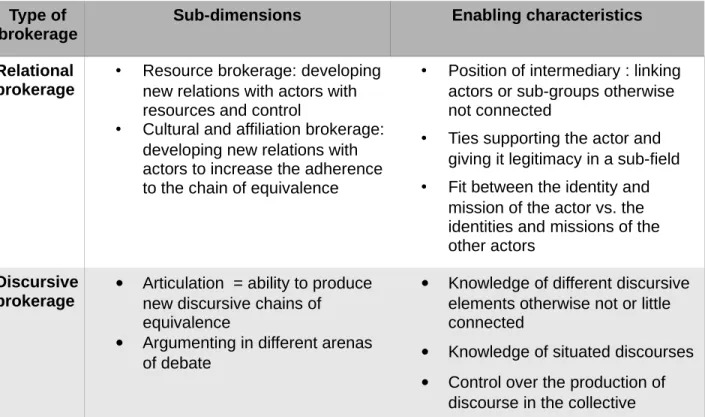
Table 2.3 Types of brokerage involved in the process of place-framing...96
Table 3.1 Dimensions of the building-block comparative design...104
Table 3.2 Discursive events analyzed for the coalition for traffic calming in Montreal...121
Table 3.3 Discursive events analyzed for the opposition to the Turcot complex in Montreal...121
Table 3.4 Discursive events analyzed for the opposition to the Nieuwe Westelijk Oeververbinding (NWO) in the Rotterdam The Hague area...122
Table 3.5 Discursive events analyzed for the discourse coalition 'Smart working, smart travelling' in the Netherlands...123
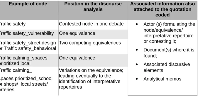
Table 3.6 Coding technique for the discourse analysis...126
Table 4.1 Civic-led programs for traffic calming and the promotion of walking and cycling in Montreal...143
Table 4.2 Involvement of local networks on mobility : civic actors contributing to a local governance of traffic calming...175
Table 5.1 Major brokers from the discourse coalition opposing the MTQ's Turcot project...197
Table 6.1 Timeline of parliamentary debates with discussions about the Nieuwe Westelijk Oververbinding, with the themes discussed...211
Table 6.2 The main actors involved and their motivations...223
Table 7.1 Brokers and their roles...261
Table 8.1 Place-frames identified in the four case studies...285
Table A1.1 Dimensions de la recherche comparative de type « building-blocks »...329
Table A3.1 Equivalences encountered in the documents from the Centre d'écologie urbaine, supporting the chain of equivalence explained in Chapter 4...348
Table A3.2 Equivalences encountered in the documents from the Conseil régional de
l'environnement, supporting the chain of equivalence explained in Chapter 4...349
Table A3.3 Equivalences encountered in the documents from the Équiterre, supporting the chain of equivalence explained in Chapter 4...350
Table A3.4 Equivalences encountered in the documents from the Vélo-Québec, supporting the chain of equivalence explained in Chapter 4...351
LIST OF FIGURES
Figure 1.1 The territory of the Montreal Metropolitan Community (CMM), with its 5 main sectors and important transport projects discussed...20
Figure 1.2 Randstad, with its four main cities ...24
Figure 4.1 Three broker-centered networks in programs for traffic calming...147
Figure 4.2 The network of actors related to the local leaders of the Green, active and healthy neighborhood projects ...149
Figure 4.3 Sample of pictures shown in the plans of the Green, active and health neighborhoods from the Centre d'écologie urbaine...172
Figure 6.1 Choices between the Orange and the Blankenburgtunnel, as presented by the NWO Project Buro for the Ministry of Infrastructure and Environmental...208
Figure 6.2 Representation of the highway network around Rotterdam, in the justification for the NWO by the Ministry of Infrastructure and Environment. Accessible at :
http://www.rijksoverheid.nl/documenten-en-publicaties/rapporten/2013/11/05/rijksstructuurvisie-bereikbaarheid-regio-rotterdam-en-nieuwe-westelijke-oeververbinding.html ...215
Figure 6.3 All new planned (or potential, in dotted lines) highways, as represented by
Milieudefensie (Friends of the Earth Netherlands)...225
Figure 6.4 Logo from Milieudefensie, front page of the plan Building together a Green Metropolis ...229
Figure 6.5 Members of parliament on the Green Metropolis map, before the June 2011
parliamentary debate...240
Figure 6.6 Network representation of the brokers from the Coalition Vitaal Midden-Delfland, their supporting network and share of resources...243
LIST OF ABBREVIATIONS
ABCN Actiecomité Blankenburgtunnel Nee (resident action committee against the Blankenburgtunnel in South Holland)
AMT Agence Métropolitaine de Transport (Metropolitan Transport Agency)
BAPE Bureau d'audiences publiques sur l'environnement (Public hearing commission on the environment, province of Quebec)
CEUM Centre d'écologie urbaine de Montréal (Montreal Urban Ecology Center)
CMM Communauté métropolitaine de Montréal (Montreal Metropolitan Community) CRE-Mtl Conseil régional de l'environnement de Montréal (Environmental Regional
Council, Montreal)
DSP Direction de santé publique de l'Agence des services sociaux et de la santé de Montréal (Montreal Public health agency)
GRUHM Groupe de recherche urbaine Hochelaga-Maisonneuve (Urban research group from Hochelaga-Maisonneuve)
MIM Ministerie van Infrastructuur en Milieu (Ministry of Infrastructure and Environment)
MTQ Ministère des Transports du Québec (Ministry of Transport, province of Quebec)
NWO Nieuwe Westelijk Oeververbinding (New west river-bank connection)
PSWST Platform Slim Werken Slim Reizen (Platform Smart Working Smart Travelling) RWS Rijkswaterstaat ('water state agency', executive agency of the Minister from
Infrastructure and Environment) VdM Ville de Montréal (City of Montreal)
INTRODUCTION
How often is it argued, in public debates, that an issue would be better handled by considering a broader territory, or by refocusing the spatial understanding of a phenomenon? The boldest participants even argue for a new distribution of political power: for a better or more coherent intervention, we would need only to give more power to their neighborhood, city, or to the metropolitan agency. Although spatial claims abound, we understand little about their use. How are they formulated, who do they convince and for what effects? How do they relate to the participants' own relation to place and to tactics to manoeuver in a given political context? Do spatial claims ask for radical, incremental or cosmetic changes to institutions and the content of policies?
This thesis explores these questions through the investigation of coalitions for car alternatives in two metropolitan areas. Mobility in the city is studied as a topic of contention and collective action. In the regions of Montreal and Rotterdam The Hague, I investigate the discourses and networks from coalitions requesting other modes of mobility as well as another making of space for this mobility. In short, the coalitions studied aim at transforming dominant discourses on mobility and the city. These coalitions are situated in different contexts, providing interesting contrasts on the challenges faced by such coalitions.
A framework is elaborated to understand the processes through which the making of coalitions and the construction of discourses take place. Two main concepts are used to do so. First, coalitions are pictured as constituted within a web of affiliations (Simmel 1955), with each participant having his or her own loyalties and motivations. Brokers are needed to bring these actors together and maintain the coalition united. These brokers also face the challenge of elaborating an efficient counter-discourse to the dominant ones, a counter-discourse able to pull together the different motivations.
Second, the discourse theory from Laclau and Mouffe (1987) is used. This theory posits that the force of an idea resides in the linkages it makes among different elements. The concept of community, for example, is a strong political idea only because of the elements to which it is associated, giving it significance in the political discourses. When the meanings of the different elements become disconnected, the force of the political idea is reduced. And when this political idea was the glue uniting actors together in a collective, then the collective will likely dissolve. This is, in short, the essence of the approach to coalitions and discourse that I propose in this thesis.
This framework on coalitions and discourse is used to investigate the use of specific types of spatial claims, place-frames. Place-frames, as strategic representations of sites used to transform dominant discourses, are defined and discussed in relation to other notions in the literature. Place-framing is the process through which such counter-discourses are constituted. Place-framing is dynamic because it is elaborated in relation with the different motivations of the participants to the coalition, and in relation with the discourses external to the coalition.
The thesis starts with an introduction to the politics of mobility in cities and metropolitan areas, with particular attention given to the Dutch and Québec cases. The second chapter discusses the literature on social networks, discourse, and space. It ends with a synthesis of the conceptual framework used in the investigation of the case studies. The third chapter presents the methodology and data collection tools, as well as the comparative research design. The heart of the thesis is made of four case-studies, two in the region of Montreal and two in the region of Rotterdam The Hague. The four cases correspond to different building-blocks for the study of place-framing. They differ in the relation of the coalition to conflict and in the opportunity of alliances with public authorities. Two case studies are presented at length, with the brokerage observed and the detailed analysis of the context. Two other case studies, one by city-region, follow the same analytical process but are presented more synthetically. These shorter cases are there to offer a contrast to the longer cases. They supply another perspective in the same region.
The cases were investigated with a total of 40 semi-focused interviews, 4 focus groups, some direct observation of events, a discourse analysis of 15 (transcribed) debates, varying in length and corpus, and a discourse analysis of a series of documents produced by members of the coalitions and public authorities.
The case studies begin with the discourse coalition for the promotion of spaces for car traffic calming in Montreal, in chapter 4. This first case presents a collaborative type of collective action linking together regional civil society actors, working as brokers between the public health sector and local community organizations in neighborhoods. They developed a place-frame of a dynamic local community enabling the practice of walking and cycling. The second case study is shorter, but presents a no less fascinating discourse coalition (chapter 5). The coalition opposed the reconstruction of the Turcot highway complex as designed by the Ministry of Transport of Québec. The members of the coalition argued for a multi-scalar place-frame linking local conditions of inhabitance with the need for an efficient metropolitan public transit axis.
The third case study carries us to the Netherlands, in the region of Rotterdam The Hague (chapter 6). This longer case study is a contentious case where a coalition opposed a new highway segment in between the two agglomerations. The discourse coalition defended a place-frame supporting the preservation of a 'natural' place targeted by highway extensions, Midden-Delfland, and linked place perservation to a wider territoriality to the decision-making process. We will see the key similarities and differences in the challenges faced by this discourse coalition and the one against Turcot in Montreal.
The fourth and last case study, in chapter 7, is a shorter case on a collaborative discourse coalition working in close partnership with the national government in an entrepreneurial tackling of road congestion. The place-frame argues for a flexible work space and a mixed public-private-civic regional governance of investments in transport infrastructure and mobility management. After the four case studies are presented in their own context, each with their own sequence of discourse and network evolution, the cases are contrasted in chapter 8. In chapter 8, the discussion follows the order of the propositions that are formulated at the end of chapter 2 (the conceptual chapter). The thesis ends with a general conclusion. For French speakers, a 20- page synthesis of the thesis in French is provided in Appendix 1.
CHAPTER 1. THE POLITICS OF (AUTO)MOBILITY IN CITIES AND
METROPOLITAN AREAS
Mobility is part of daily practices and of our experience of the city (Orfeuil 2008; Cresswell 2010; Desrosiers-Lauzon and Boudreau 2011). Mobility is enabled and constrained by the provision of transport infrastructure and services. Transport infrastructure participates in important ways in the production of urban space, affecting the shape of the metropolitan area and the conditions of residence in it. Choices in transport investments mean choices in the mobility modes financed and promoted by the state, and their associated hold on public spaces (through parking spaces, the width of streets and of side-walks, etc.). Choices on transport infrastructure also influence the level of car traffic in the city and the sprawling of the metropolitan area, affecting both urban and global environmental conditions. Transport infrastructure are also determinant for accessibility to destinations. They construct disparities in accessibility, and disparities in the attractiveness and liveability of urban places (Young and Keil 2010; Graham and Marvin 2001). Transport and mobility in the city thus imply important collective choices, which are the topic of public debates and of more or less open decision-making processes.
I am interested in the making of urban space for mobility as an object of contention and collective action. Contention in the shaping of urban space for mobility is experienced at different levels. Desroziers-Lauzon and Boudreau (2011) have suggested that mobility is involved in three 'rhythms' of the construction of metropolitan space: the rhythm of daily life, of the cyclical occurence of events of debates, and of institutional change. Indeed, mobility is part of the daily experience of the city. There are conflicts in the daily use of urban space between different mobility modes, and in the overlap of the mobility flows with other uses in places. Mobility is also part of political debates on the form of the city and, as we discussed above, the provision of infrastructure. The making of space for mobility is regulated by certain norms and forms of expertise. On the topic of transport, there has particularly been an institutionalization of norms with the traffic engineers framing in a certain way the 'urban transportation problem' (Hanson 2002). These norms have been debated among experts of transportation planning in interaction with users. Indeed, the conflict between car mobility and the other uses and desires for urban space has triggered much public debate. These expertises in transportation planning has sedimented in certain institutions still regulating transport infrastructural decisions today. In addition, mobility debates also include challenges for the urban political institutions, mobility
patterns trespassing political boundaries and forcing some form of coordination between public authorities.
In this chapter, I present the problem-setting of making urban space for mobility. I introduce it first as an object of contention, within a broader politics of mobility and automobility. I then present the urban transportation problem from a historical perspective. This serves to introduce the social construction of mobility in the city, and the different institutions regulating it in Montreal and in Rotterdam The Hague. I follow with a discussion of the metropolitan context. The chapter finishes with a summary of these elements of the governance context and how they constitute a set of opportunities and constraints for actors defending car alternatives.
I start by defining the terms 'mobility', 'politics of mobility' and 'automobility'.
1.1 The politics of mobility, automobility and car alternatives
Drawing on Cresswell (2006, 2010), I define mobility as 'socially produced motion'. Mobility consists in the movement of individuals and goods through space, as an empirical reality, but which takes numerous meanings and strategic representations in the realm of ideas and discourse. This movement of individuals and goods is also experienced in different ways depending on mood, affect, social position and the relation to the place crossed (Cresswell 2006, 3–4; 2010, 22). Cresswell cites Delaney to emphasize mobility as movement and as a meaning-giving activity : “human mobility implicates both physical bodies moving through material landscapes and categorical figures moving through representational spaces”(Cresswell 2006, 4). The production, organizing and 'encoding' of movement constitute the politics of mobility(ies). The politics of mobility produces and is produced by disparities in privileges and social power (Cresswell 2010, 22).
In the daily experience of urban space, we can experience several aspects of this politics of mobility, as discussed by Cresswell (2010). In the making of space, there has been selective choices, and hence potential conflicts, pertainaing to the justification, channelling and designing of movement : “Why does a person or thing move?”, “How fast does a person or thing move?”, “What route does it take?”, “How does it feel?”, and “When and how does it stop?” (Cresswell 2010, 22–26). These questions cover a very broad scope of issues at different scales. I
concentrate on the urban and metropolitan spaces, and specifically on the conflicts related to automobility and its alternatives.
Automobility has been defined as the whole regime supporting and “making the use of cars both possible and in many instances necessary” (Bohm et al. 2006). This includes ideological, political and technical dimensions supporting the dominance of cars in our (urban) life styles (Bohm et al. 2006; Conley and McLaren 2009; Henderson 2013). The critical literature on automobility identifies major problems which the dominance of cars bring in our society : congestion, environmental degradation, dependency on oil (and associated geopolitical problems) and road accidents (Bohm et al. 2006, 9-10). In addition, Bohm et al. argue that automobility is impossible “in its own terms”, because of the combination of autonomy and mobility, which would be constituting the culture of automobility.
Cars need roads, traffic rules, oil, planning regulations, and the representation of car driving as autonomous movement involves disguising such conditions. It seems obvious that the more cars are around, the more rules have to be invented (eg, congestion charges and motorway tolls) to allow the regime of automobility to work ‘normally’, even though this ‘normality’ might be contradictory to the image of a completely autonomous movement. (Bohm et al. 2006, 11)
In this context, the authors argue that, “[t]he task of politics is precisely to ‘make up’ automobility, that is, to set the limits and thereby gloss over the particular antagonisms of automobility”, to reform automobility in order to reduce its negative impacts (idem, 14). The other path is the search for alternative modes of mobility. Walking and cycling, railways and tramways, all have long histories in cities (Urry 2007; Flonneau and Cuicueno 2009). These alternative modes have had a much more privileged position in urban mobility practices in the past. But the growth in the use of cars has changed cities and the conditions for other modes of transportation. With the explosion of cars and highways came movements to 'reclaim the streets' and oppose the destruction of urban heritage areas. The disciplines of urban planning and urban design now make a plea to make 'cities for people, not for cars' (Gehl 2010).
Although there have been improvements in the inclusion of public transit, walking and cycling in central areas of cities, Henderson still speaks of a 'street fight' in San Francisco (2013). Even if this City is perceived to be a front-runner of sustainable mobility, urban dwellers practicing alternative modes of mobility need to mobilize to ensure a place for car alternatives on the
streets. The struggles to make room for car alternatives in the city are met by opposition and dismissive claims.
Loud opposition to removing car space and parking permeates the discourse on mobility in San Francisco. The preservation of automobility is often justified on claims that transit systems are slow and impractical and that bicycling is unsafe and things are too far apart to walk. All of this is true to a certain extent [...] but it is a self-reinforcing feedback cycle. To break the cycle requires a rethinking of urban space and perhaps a moment of inconvenience for the motorist. (Henderson 2013, 193).
The claims to reorganize urban space around alternative modes can signify a quite different form to cities. Each mode has its own requirements for urban space, and its own set of infrastructure needed to sustain it: trains need train stations and railways, cars need parking spaces, walking and cycling need calmer streets with mixed and dense urban environments (Henderson 2009, 71). Spatial planning, but also economically regulated spatial development, participate in the structuration and reproduction of these mobility regimes. Car alternatives thus include not only the alternative modes of mobility, but also the organization of urban space making the practice of these alternative modes possible. Patton gives an example of a different kind of city in which the pedestrians would be at the top of the hierarchy of urban mobility:
As a thought experiment, imagine a city in which the sidewalks were continuous; in which the streets were interrupted at every intersection by sidewalks; in which drivers crossed sidewalks rather than pedestrians crossing streets. In effect, such a city would replace every crosswalk for pedestrians with a speed hump for drivers. It would manifest one kind of reversal in the hierarchical ordering of motor-vehicle flows over pedestrian places. Such a city is radical, visionary, or inconceivable because it would constitute the material manifestation of a very different rationality. (Patton 2007, 932)
I now propose to problematize the making of urban space for mobility from a historical perspective on the debates regarding the inclusion of car infrastructure in cities.
1.2 The framing of the urban transportation problem
The conflict between the planning for cars and the planning for people (or, more precisely, people's other valuations of daily space) in the city is far from new. In fact, historians present it
as the core debate in the parallel evolution of traffic engineering and urban planning, and their adjustments in the face of public debates (Hebbert 2005; Mom and Filarski 2008; Norton 2008; Brown, Morris, and Taylor 2009). In this section, I present this evolution and introduce how it historically played out in the planning of car infrastructure in the two regions investigated for my case studies.
Cities have for long been confronted with the crowding of roads making the circulation of persons and goods unefficient. Beaudet and Wolff (2012) recall the measures taken to solve this problem in the Rome of Julius Caesar and in the London of Henry VII. There was already then an issue with the accessibility of goods and persons to the city. The massive growth in the use of motorized vehicles, however, added another crucial element to the problem: the danger of high speed (Hebbert 2005, 40). In a historical study of the street in American cities of the 1920s and 1930s, Norton (2008) discusses the evolution of the traffic engineering's expertise in interaction with changes in the prevailing social meaning given to the street. In the 1920s, cars were first seen as intruders in streets where all other kinds of uses were legitimate.
With the sudden arrival of the automobile came a new kind of mass death. Most of the dead were city people. Most of the car’s urban victims were pedestrians, and most of the pedestrian victims were children and youths. Early observers rarely blamed the pedestrians who strolled into the roadway wherever they chose, or the parents who let their children play in the street. Instead, most city people blamed the automobile. City newspaper headlines, editorials, letters, and cartoons depicted the automobile as a destructive juggernaut. (Norton 2008, 11)
In that context, the engineers' work was to reduce the negative impacts of this minority of car users on the vulnerable and rightful majority. But then Norton identified a transition in the understanding of the street through “a struggle for legitimacy, culminating in a new effort by automotive interest groups to question pedestrians' customary rights to the streets” (17). The congestion and crowdedness in the streets correspond to inefficient uses of space. The new discipline of 'traffic control' is born in that period (mid 1920s) with engineers hired by business associations and city authorities to make plans for traffic efficiency. Norton describes a last round of discourse on the street, in terms of freedom: “Through this problem definition, it could characterize low limits as oppressive – an impediment to freedom.” (Norton 2008, 6)
From an original focus of traffic engineering on traffic safety, was added a focus on fluidity, encouraging even further the separation of the different mobility modes. In planning too, notions were developed to ensure safety and liveability of residential neighborhoods. The unit of the neighborhood preserved from transiting traffic was introduced already in 1920 by Perry (Ben-Joseph 2005, 64–65).1 Principles of the fluid 'townless highway' and of the protected
'highwayless town', merged into a system of road hierarchy segmenting cities in spaces of movement and spaces of stay (Hebbert 2005, 40). For Hebbert (2005, 40): “Road hierarchy has provided a robust basis for managing the risk of a motorized society.” The modernist architects who published the Athens Charter in 1933 also pushed for the segregation of urban spaces following their functions : inhabit, work, recreate and circulate. This separation of functions was closely tied with hygienist objectives to make the city a more sanitary, aerated, and healthy de-concentrated space, separating residential zones from polluted industries and roads. The different forms of circulation also ought, in their model, to be segregated. Through the norms of road hierarchy and the separation of functions in functionalist planning, we see that both traffic engineering and urban planning developed codes and standards coming from mixed societal objectives of fluidity, traffic safety and public health. These objectives converged in a segregation of spaces of fluidity and the rest of urban life.
The separation of car traffic from the rest of urban life for safety and fluidity purposes was however contested and reinterpreted in different urbanistic ideals (Beaudet and Wolff 2012). Jane Jacob criticized vigorously urban renewal programs and the development of urban highways bringing 'The Death of Great American Cities', for the costs they impinged on the dense and mixed urban fabric, fabric which for her was closely tied to the dynamism of urban social life. She precisely valued the non-separation of different functions. Jacobs considered it was not the cars at such that had been the problem, but the transformation of the city for their circulation, with priority spaces for fluidity 'eroding' the city liveliness. If the cars would be allowed to function in the urban morphology as it was, then a process of 'attribution' would reduce their use to a minimum, naturally, for a compromise to preserve the dense and lively urban streets. “How to accomodate city transportation without destroying the related intricate and concentrated land use? - this is the question. Or, going at it the other way, how to
1 Perry developed in 1920 a series of criteria, that, amusingly, are the almost identical to the criterion defining the
'green neighborhood' protected from through traffic from the City of Montreal, which we will discuss in Chapter 3 : size, presence of a school, boundary on all sides marked by arterial streets, internal street system 'designed to discourage through traffic', public spaces, institutional site and local shops (Clarence Perry, “The Neighborhood Unit”, p.33-34, cited by Ben-Joseph (2005, 65).
accomodate this intricate and concentrated city land use without destroying the related transportation.” (Jacobs 1961, 340)
Jacobs wrote her book during the postwar period in which traffic engineers came to take more importance in the debate of transport in the city. Vigar (2001, 270) recalled that in the 1950s onward was an era of 'heroic engineering' during which it seemed that all problems could be solved by engineering solutions. Traffic engineers had developed “simple forecasting techniques whereby recent demand history for each mode was simply extrapolated to provide a picture of future demand” (Vigar 2001, 283). Those forecasting models justified the construction of new roads, especially inter-urban highways: “Rail use was falling, road use increasing. Broader social and environmental objectives did not play a part in trying to shape these demand profiles. In effect, policy was driven by past demand, not shaped by broader objectives” (idem, 283). This paradigm of transport intervention was coined by Vigar 'predict and provide'. In the context of increasing power from the traffic engineers in national departments, and their reliance on such approach, there was nevertheless a more multi-modal approach in certain cities, which in many instances had some room of manoeuver (Vigar 2001; Mom and Filarski 2008).
There were thus debates, in several countries, on the manner to resolve the tensions created by the desire to have fluid spaces of mobility and the other desire to preserve other values given to urban (and nature) spaces crossed. The famous report 'Traffic and towns', published in 1963 in Great Britain (and translated in French and German), show how much these issues were discussed. The Buchanan report had been commissioned by the Great-Britain Ministry of Transport to find solutions to the problem of road congestion. The report framed the debate in a clear choice, with two variables. On one side there were environmental zones (or neighborhoods) to preserve. On the other there was car circulation that could benefit cities. It was about choosing “an acceptable balance between environmental quality and accessibility” (SKM Colin Buchanan 2013, 14), a balance that should be decided by each local community. Although the report was nuanced and showed different costs and benefits, the reconstruction of towns around a hierarchical road system, with urban freeways, was the key message which stayed and stirred debates (SKM Colin Buchanan 2013; Beaudet and Wolff 2012).
The Dutch compromise: sparing cities from highways
In the Netherlands, the Buchanan report on 'Traffic and Towns', and especially its conclusion on urban highways, associated with the American model, provoked heavy criticisms. A renowned transportation planner stated that “[t]he European cities have been less plagued by the war than
many American cities by motorization” (Goudappel, cited by Mom and Filarski 2008, 348). Planners argued instead, at this same time in the Netherlands, for the pedestrianization of downtown areas of Dutch cities. Yet the federal department Rijkswaterstaat was also developing a vision of highway development, with pressures from several groups in civil society. Road policy became more and more embedded within Rijkswaterstaat, the executive agency of the then Ministry of Transport, and now Ministry of Infrastructure and Environment. Rijwaterstaat (RWS) was founded in the 18th century with a mandate to build and manage waterworks in the Netherlands. It later became the planner and operator of the highway system. It has been the locus of the Dutch engineering flourishment, especially in water and dam projects, and afterward in the post-war re-building efforts. In the 1966 national planning document were 'spatial policy' and 'road policy' for the first time recognized as policy topics of equal value (idem, 323). RWS was devoted to the more technical aspects of transportation planning, such as prognostics (the prediction of demand) and the standardization in the design and speed of roads. The policy of RWS was however heavily contested in the 1970s for its too little consultation of citizens and the emphasis on the car road network (Geels 2007; Mom and Filarski 2008).
The expansion of highways was particularly visible between urban agglomerations of the Randstad (area formed by the four largest cities of the Netherlands). But the City of Rotterdam was particularly affected. Largely destroyed during the Second World War, it was rebuilt with a form very different from traditional Dutch cities. This happened with the support of the local economic and political elites who, already in the 1930s, had wanted to give an image of modernity to Rotterdam. The city became the experimental locus of the highway network from the Netherlands (Mom and Filarski 2008). The highway network built in and around the city participated to the national and international transport network. This extra local function became ever more important in the following decades with the Port of Rotterdam's growth as a key economic engine of the Netherlands, linking local transportation issues with Europe and beyond. The expansion of the highway network around Rotterdam will be the topic of one of my case study, in chapter 6.
According to Mom and Filarski (2008), the expansion of the highway network in the Netherlands was kept in check by planners, especially in regard to its influence on urban areas. There were also oppositions to the “modernization of cities”, which led to streets' occupations and civic unrest (Mom and Filarski 2008; Mamadouh 1994; Rooijendijk 2005). The local bylaws also gave a tool to activists to contest the construction of highways in their local environment, as well as to
preserve natural and open green areas (Mom and Filarski 2008, 364-365). One such case is the decades long opposition to the A4 highway between Rotterdam and The Hague, which we will speak of in one of our case study, chapter 6.
Besides heritage conservation, protestations to the modernization of cities for cars had for topic the liveability of urban life with children, that was threatened by increasing car traffic. In the end of the 1960s, residents started to put plant pots and garden benches on the streets, in front of their houses, to limit the passage of cars and show that it was an inhabited space. Those initiatives evolved into experiments on the concept of the 'woonerf', supported by local municipalities (de Wit and Talens). The concept of 'woonerf' was introduced in 1976 in the national road safety code. In 1978, 175 municipalities (20%) had designed one or more 'woonerf' (Mom and Filarski 2008, 340). The 'woonerf', which we can translate by 'inhabited space', consists in the design of a street that allows the careful passage of cars: cars are guests in an inhabited space, with vegetation, benches, play areas and parking. Other measures of traffic calming were also implemented at the time in neighborhoods (Kraay 1986). The issue of traffic safety was also central in the struggle to preserve space for cyclists, and led to the re-implementation of dedicated cycling paths. At the national level also, organizations requested new measures and standards to ensure traffic safety. Historians conclude from this period that the spatial planning tradition and the public uprising participated to the focus of traffic engineering on the safety issue in the Netherlands (Mom and Filarski 2008).
In sum, “traffic engineering in the Netherlands is an episode in a tradition largely determined by spatial planning” (idem, 358). Planners and traffic engineers came to a compromise, in the tradition of the polder model of Dutch governance which I will describe below, leading to constraining cars for the objective of preserving not only safety but also the urbanity of cities (idem, 359). The compromise consisted in constraining cars within urban agglomerations. Car infrastructure between cities did however develop into one of the densest and more congested highway networks of Europe (Mom and Filarski 2008, 397). The expansion of the Port of Rotterdam and of the airport Schiphol also justified increased inter-urban highway development in the following decades.
Montreal's first highways and their urban integration
In Montreal, there was first no such strong reticence to highways in the city. The first highway plans were designed by Montreal planners. In the context of the little involvement of higher state authorities, Poitras (2009, 111-112) explained that Montreal planners, with the help of
international consultants, took the lead in the making of plans to improve transport in the city. In 1948, the City planners presented the under-ground metro system as well as the making of two freeways (autostrades), one north-south and one east-west, as solutions to the mass transportation problem. But the freeways were also described as opportunities of urban renewal and urban development, an association which has been documented also in the United States (Gagnon 2007, 124, Poitras 2009; Jacobs 1961; Altshuler and Luberoff 2003; Mohl 2004). The urban planners desire for urban development and sanitary improvements of housing in the city converged with the quest for traffic fluidity.
The concept of highways was used for the first time in the province of Québec in the 1950s, the first highway linking Montreal to the northern cottage area in the Laurentides. When the first highways were built in Montreal (Décarie, Métropolitain), there were negotiations between Montreal planners and the Ministry of Roads on the better routes and design to minimize the fracture of the urban fabric (Noppen 2001; Gagnon 2007; Desjardins 2008a). The provincial Ministry of Roads had experience in building roads in rural areas. From 1936 to 1959, it was responsible of the wide road development linking all regions of the province (Desjardins 2008a, 102).
From the 1960s onward the Ministry became only responsible for the rapid road network and left local roads to municipalities (Desjardins 2008a, 107-108). In 1973, the Ministry of Transport (MTQ) was created and replaced the former Ministry of Roads. It then integrated public transit in its mission. Its previous history of road provider, however, showed in its following interventions. In his history of the recent highway projects from the MTQ, Desjardins argued that a technical vision of road projects remained dominant, and that there is “a tendency from the MTQ to present these norms [technical norms of highway design] as almost immutable in face of the public” (2008b, 300–301).
The link between freeways and the urban form was for the first time publicly debated in Montreal when the provincial government started the destruction of neighborhoods to make way for the east-west freeway. Previous urban highways had not triggered such opposition. The coalition 'Front commun contre l'autoroute Est-Ouest' united about 60 associations opposing the highway, asking for a democratization of transport policy, more public transit and the renovation and construction of housing for families with low revenues (Poitras 2009; Desjardins 2008a, 118– 119). This social mobilization was complemented by groups of urbanists and architects opposing the highway on the ground of heritage protection. After large opposition and the election of a
new provincial government, the highway construction was interrupted. The provincial government commissioned a study to decide on a policy for transport in the region of Montreal. The solution of an 'urban boulevard' was preferred to the freeway (Gagnon 2007; Noppen 2001). The study also recommended a quasi-moratorium for the construction of new highways, effective from 1977 to 1985. It was not before the mid 1990s that new concrete plans of highway development were debated again in the region of Montreal. The contemporary debates on the Notre-Dame highway and the Turcot complex, which constitute respectively the eastern part and a west section of the previously planned east-west freeway, will be discussed in one of the case studies, in chapter 5.
The debates and fierce oppositions to the east-west freeway in the 1970s re-articulated the negotiation of car circulation and visions of urbanity in Montreal, forcing a greater concern for heritage conservation. The debates also coincided with the institutionalization of spatial planning in the province of Québec and the introduction of participatory obligations in spatial, environmental and transportation plannings, with legal frameworks adopted in the end of the 1970s. The Ministry of Transport, created in 1973, had afterward to conduct public debates and environmental impact assessment. Nonetheless, the City of Montreal and the Ministry of Transport have, since the end of the 1990s, grown more apart from each other in their proclaimed visions of the future of transport in the Montreal metropolitan area.
I wish to draw a few conclusions from this historical perspective on the integration of car infrastructure in the cities of my case studies. The two disciplines of traffic engineering and urban planning influenced one another and evolved in reaction to the public oppositions. Societal objectives for fluidity, but also very much for traffic safety and public health, were part of norms defining transport in the city. According to historians however, traffic engineering evolved in the post-war period into a specialized field relying on technical predictions of traffic, with the model predict and provide. The standards and plans developed were criticized, with opponents asking for other articulations of the objective for fluid circulation with other values given to place. The outcome of these debates depended of the context. The power interplay between planners and engineers, and between local authorities and central state authorities, was repeatedly identified by historians as a key issue in the making of the city for car mobility (Vigar G. 2001; Mom and Filarski 2008; Brown, Morris, and Taylor 2009; Geels 2007; Desjardins 2008b). Decisions on the making of urban space for mobility were affected by the power differentials between state authorities at different scales, and their interaction with actors outside the state.
Since highway development projects have started again with new speed in both sides of the Atlantic2, new environmental and participatory regulations have been put in place; and the
transport departments integrated in their mission a multi-modal approach to the urban transportation problem. Yet, the provision of infrastructure and services for other mobility modes has been for the most part delegated to other authorities outside the Ministries of Transport. Hebbert note that “a dangerous gap is now opening between the street paradigm and the inertia still embodied in official highways standards. Institutionally, most new thinking has been sponsored by non-transportation branches of government” (2005, 55).
The urban transportation problem has become a metropolitan transportation problem, which has additional characteristics. For one, the reflection about the localization and design of roads and freeways should not rely on a simple opposition between urban versus rural areas. In contemporary debates, highways in metropolitan areas are also discussed in terms of polarities between the central city and the suburbs, or between the different centers of a polycentric metropolitan region. In addition, mobility poses new challenges, practical, political, and institutional challenges, because mobility patterns go well beyond the limits of specific municipal authorities. To some extent, this was already an issue in the 1940s when the Montreal urban planning department was designing a metropolitan transportation plan going beyond its own municipal limits (Poitras 2009), and when in the 1950s the Rotterdam highway network was planned to deliver goods and persons throughout the country and Europe. Yet, the current metropolitan dynamics involve new political and governance issues linked to mobility, which I introduce below.
1.3 The politics of (auto)mobility in the metropolitan context
Mobility is now understood as a principle organizing the metropolitan space (Bourdin 2007; Sénécal 2011). Mobility patterns shape metropolitan areas. Filion and Kramer describe the picture of 'dispersed urbanization' having led to “heavy dependence on the car, relatively low density, rigid functional specialization and a scattering of structuring activities” (2012, 2238). They discuss how this dispersed urbanization came to be, with two parallel planning and regulating processes. The first process, described above, is the transportation engineering
2 The abandon, delaying or reduction of highway development from the end of the 1970s to the mid 1990s was not
only attributed to opposition and contestation, but also to economic reasons, with the important reduction of transport investments in the two cases discussed.
planning in terms of predicting mobility demand and providing roads for it, which lead to heavy highway development from the 1950s to the 1970s. The second process is the more fragmented spatial and housing provisions, i.e. the adoption of bylaws by municipalities allowing for sprawl and the dominance of low-density housing. Low-density housing and the scattering of activities through space led to a dependence on the automobile, further encouraged by a growing highway network. “Once its fundamentals were in place, urban dispersal engaged in a self-reinforcing process whereby most subsequent transport and land use changes further entrenched dispersion” (Filion and Kramer 2012, 2239).
A comparison of North America with the Netherlands, however, requires caution on the weight given to (the absence of) planning in dispersed and car-dependent urbanization. The Netherlands has a long tradition of spatial planning trying to control the evolution of urban form, which I summarize here by relying on the synthesis from Schwanen and colleagues (2004). In the 1970s and early 1980s, the Dutch implemented a national spatial planning policy of 'concentrated decentralization' aiming at concentrating suburban growth within identified growth centers accessible by train. The objective of this control of urban growth was to reduce urban sprawl, and especially its effect on the 'Green heart'. The 'Green heart' refers to the green (and relatively) open area in the center of the ring of the largest Dutch cities. In the beginning of the 1980s however, inner city decline pushed planners to question their policy of 'concentrated decentralisation', which had successfully concentrated, but nevertheless encouraged, suburban development. They adopted instead, from then on, a compact city policy: further growth ought to be concentrated within existing cities or in close-by greenfield sites. The focus on housing development, however, left commercial development and especially employment centers develop outside the core cities. Shopping malls outside the city boundaries were however prohibited. Taken together, these planning measures encouraged the use of walking and cycling in cities, especially for shopping and daily activities. But many employment centers were scattered outside urban centers. In addition, the suburban growth centers encouraged the use of cars, in addition to the development of the inter-urban highway network facilitating it. The same phenomenon occurred in several of the more recent brownfield developments close to urban center, where the accessibility to public transit was low during the development phases. The coupling of mobility and land-use in planning is far from an easy business. Schwanen, Dijst and Dieleman conclude that “notwithstanding its strong planning tradition, commuting patterns in the Netherlands are not exceptionally efficient”. (Schwanen, Dijst, and Dieleman 2004, 594) “The