HAL Id: hal-02164311
https://hal-mines-paristech.archives-ouvertes.fr/hal-02164311
Preprint submitted on 25 Jun 2019
HAL is a multi-disciplinary open access
archive for the deposit and dissemination of
sci-entific research documents, whether they are
pub-lished or not. The documents may come from
teaching and research institutions in France or
abroad, or from public or private research centers.
L’archive ouverte pluridisciplinaire HAL, est
destinée au dépôt et à la diffusion de documents
scientifiques de niveau recherche, publiés ou non,
émanant des établissements d’enseignement et de
recherche français ou étrangers, des laboratoires
publics ou privés.
Distributed under a Creative Commons Attribution| 4.0 International License
BASICS IN SOLAR RADIATION AT EARTH
SURFACE -REVISED VERSION
Lucien Wald
To cite this version:
Lucien Wald. BASICS IN SOLAR RADIATION AT EARTH SURFACE -REVISED VERSION. 2019.
�hal-02164311�
B
ASICS IN
S
OLAR
R
ADIATION AT
E
ARTH
S
URFACE
–
R
EVISED
V
ERSION
Lucien Wald Lecture Notes
Edition 1 from 2018-01-03 – Revised 2019-06-20
MINES ParisTech, PSL Research University O.I.E. – Observation, Impacts, Energy Center
1 FOREWORD ... 5
2 GLOSSARY ... 7
2.1 Angles ... 7
2.2 Radiation – General Definitions ... 7
2.3 Radiation at the Top of the Atmosphere ... 7
2.4 Radiation at Ground Level ... 7
2.5 Time and Time Systems ... 7
2.6 Miscellaneous ... 8
3 THE SUN AS SEEN BY AN OBSERVER AT THE SURFACE OF THE EARTH ... 9
3.1 The Sun-Earth Astronomy in Brief ... 9
3.1.1 The Sun-Earth Distance ... 11
3.1.2 Solar Declination ... 12
3.1.3 Geocentric and Geographic Coordinates ... 13
3.2 The Sun Geometry Perceived by an Observer ... 14
4 THE DIFFERENT TIME SYSTEMS AND DAYTIME ... 19
4.1 The True Solar Time, Mean Solar Time, Universal Time and Legal Time ... 19
4.1.1 The Mean Solar Time and True Solar Time ... 19
4.1.2 The Universal Time and Legal Time... 20
4.2 Sunrise, Sunset and Daytime ... 21
4.2.1 The Sunrise and Sunset ... 21
4.2.2 The Daytime ... 23
4.3 Encoding Time in ISO Format ... 24
4.3.1 Encoding Dates and Weeks ... 24
4.3.2 Encoding Time ... 25
4.3.3 Encoding Date and Time of Day ... 26
4.3.4 Encoding Time Intervals and Duration ... 26
5 THE SOLAR RADIATION AT THE TOP OF THE ATMOSPHERE... 29
5.1 Radiance, Irradiance and Irradiation: Definitions and Units ... 29
5.2 The Energy Emitted by the Sun and the Total Solar Irradiance ... 30
5.2.1 The Total Solar Irradiance ... 30
5.2.2 The Spectral Distribution of the Solar Irradiance at the Top of the Atmosphere ... 31
5.3 The Irradiance and Irradiation at the Top of the Atmosphere ... 33
5.4 The Irradiance and Irradiation at the Top of the Atmosphere on an Inclined Surface ... 36
6 THE SOLAR RADIATION AT GROUND LEVEL ... 39
6.1 The Absorption and Scattering Phenomena ... 39
6.2 The Depletion of the Solar Radiation by the Atmosphere ... 41
6.3 The Radiative Transfer in the Cloud-Free Atmosphere... 43
6.4 The Spectral Distribution at Ground level in the Cloud-Free Atmosphere ... 44
6.5 The Role of Clouds... 48
The sun produces a vast amount of energy. The energy emitted by the sun is called solar energy or solar radiation. Despite the considerable distance between the sun and the earth, the amount of solar energy reaching the earth is substantial. At any one time, the earth intercepts approximately 180 106 GW. Solar radiation is the earth primary natural source of energy and by a long way. Other sources are: the geothermal heat flux generated by the earth interior, natural terrestrial radioactivity, and cosmic radiation, which are all negligible relative to solar radiation.
As a consequence, the solar radiation influences many aspects of the earth, including weather and climate, ocean, life on earth, agronomy and horticulture, forestry, ecology, oenology, energy, architecture and building engineering, or materials weathering.
These lecture notes intend to present the fundamentals in solar radiation at earth surface to a wide community. Its content originates from lectures given to students of master degree level or higher, engineers and researchers in climate, geophysics and environment sciences, life sciences, or energy. This document should be valuable to any engineer, scientist and practitioner.
The first edition was published on 2018-01-03. This edition is a revision achieved on 2019-06-20. There is nothing new; a few small mistakes have been corrected.
The solar radiation received at a given geographical site varies in time: between day-night due to the earth rotation and between seasons because of the earth orbit. At a given time it also varies in space, because of the changes in the obliquity of the solar rays with longitude and latitude. Notwithstanding the effects of the clouds and other atmospheric constituents, the solar radiation received at a given location and time depends upon the relative position of the sun and the earth. This is why both sun-earth geometry and time play an important role in the amount of solar radiation received at earth surface. A major part of this textbook is devoted to this matter. The geometry of the earth relative to the sun is described as well as its variation throughout the year. The concept of time is very important in solar radiation. It is detailed here and the notions of mean solar time and true solar time are dealt with. The apparent course of the sun in the sky is described; the solar zenithal, elevation and azimuthal angles are defined. These angles are identical at top of the atmosphere and earth surface; no change is introduced by the atmosphere. Equations are given in this part that can be easily introduced in e.g., a spreadsheet or a computer routine, to compute all quantities and reproduce the figures. Both horizontal and inclined surfaces are dealt with.
The amount of solar radiation that is intercepted by the earth varies because of variations in sun-earth distance and as far as the spectral distribution is concerned by day-to-day variations due to solar activity. The closer to the sun the earth, the greater the solar irradiance impinging on a plane normal to the sun rays and located at the top of the atmosphere. The total solar irradiance, often abbreviated in TSI, is the yearly average of this irradiance during a year integrated over the whole spectrum. The variations within a year amount to ± 3 % of the TSI. The spectral distribution of the extra-terrestrial radiation is such that about half of it lies in the visible part of the electromagnetic spectrum. It produces daylight and is well perceived by the human vision system. Other parts of it are in the near-infrared and ultraviolet ranges. A series of equations is offered to compute the extra-terrestrial total radiation for any instant and for any inclined surface.
During its path downwards to the earth surface, the constituents of the atmosphere deplete the incident solar radiation. On average, less than half of extra-terrestrial radiation reaches ground level. A good knowledge of the optical properties of the atmosphere is necessary to understand and model the depletion of the radiation. The description and modelling of the optical processes affecting the solar radiation within the atmosphere is called radiative transfer. The phenomena of scattering and absorption are presented and the effects of molecules, aerosols, gases and clouds on radiation are discussed. Several examples are given that illustrate atmospheric effects as a function of the solar zenithal angle and atmospheric optical properties.
Even when the sky is very clear with no clouds, approximately 20 % to 30 % of extra-terrestrial radiation is lost during the downwelling path by scattering and absorption phenomena by aerosols and molecules. The role of the clouds is of paramount importance: optically thin clouds allow a small proportion of radiation to reach the ground while optically thick clouds create obscurity by stopping the radiation downwards. The magnitude of the depletion of the radiation varies with wavelength and the spectral distribution of the solar radiation is modified as the radiation makes its path downwards. The spectral distribution is discussed for several different conditions.
6 BASICS IN SOLAR RADIATION AT EARTH SURFACE
The direct, diffuse and reflected components of the solar radiation at earth surface are defined. How to compute them on an inclined surface is briefly discussed and equations are provided.
The direct radiation is the radiation coming from the direction of the sun. Only direct radiation is present at the top of the atmosphere. On the contrary, the radiation at surface comprises a direct and a diffuse components, the sum being called the global radiation. If a tilted surface is under concern, then it may also receive a reflected component that is a part of the radiation reflected by the surrounding landscape. How to compute each component on an inclined surface is briefly discussed.
A last word. Readers may regret the lack of colours in graphs. It is true that colours greatly improve the legibility of graphs. The author knows from his experience that this document will be printed, and in part in places where colour printers are a luxury that not everyone may afford. Hence, it is his own choice to avoid colours in this text.
2.1
A
NGLESSolar declination: The angle formed by the direction to the centre of the sun and the terrestrial equatorial plane. Solar zenithal angle: The angle formed by the direction of the sun and the local vertical.
Solar elevation angle: The angle formed by the direction of the sun and the horizon.
Solar azimuthal angle, solar azimuth: The angle formed by the projection of the direction of the sun on the horizontal plane and the north.
2.2
R
ADIATION–
G
ENERALD
EFINITIONSBroadband irradiance: The irradiance integrated over a large spectrum. It is not well defined and is used as a current term to denote that the radiation is integrated over a certain range of wavelength. It may be used to denote the solar radiation measured by pyranometers, e.g. from 300 nm to 2200 nm. One may find broadband UV that opposes to spectral UV.
Irradiance: The power received per area; unit is W m-2.
Irradiation: The energy received per area; unit is J m-2. The unit Wh m-2 is commonly used in commercial metering of electrical energy but should be avoided.
Radiant energy: The amount of energy that is transferred by radiation. It is expressed in J (Joule). Radiant flux: The time rate of flow of the radiant energy. It is expressed in W (Watt).
Radiance: The radiant flux per unit solid angle per unit area. Unit is W m-2 sr-1.
Spectral distribution of the irradiance: The distribution of the irradiance as a function of the wavelength. Total irradiance, irradiation: The irradiance, irradiation, integrated over the whole spectrum.
2.3
R
ADIATION AT THET
OP OF THEA
TMOSPHEREExtra-terrestrial radiation, irradiance or irradiation: the total radiation, irradiance and irradiation originating from the sun impinging on a horizontal surface located at the top of the atmosphere.
Total solar irradiance: The yearly average of the solar irradiance impinging on a plane normal to the sun rays and located at the top of the atmosphere. It is often abbreviated as TSI.
2.4
R
ADIATION ATG
ROUNDL
EVELDiffuse irradiation, irradiance: The downward scattered shortwave irradiation, irradiance, coming from the whole hemisphere, with the exception of the solid angle of the sun disc. This does not usually include the part of the irradiation reflected by the ground in the case of an inclined receiving plane.
Direct irradiation, irradiance: The shortwave irradiation, irradiance, coming from the solid angle of the sun disc.
Global irradiation, irradiance: The shortwave irradiation, irradiance, received at ground level; it is the sum of the direct, diffuse and reflected irradiations.
Reflected irradiation, irradiance: The irradiation, irradiance, reflected by the ground and impinging on an inclined receiving plane.
2.5
T
IME ANDT
IMES
YSTEMS8 BASICS IN SOLAR RADIATION AT EARTH SURFACE
Time – legal time, local time, standard time, civil time, local clock time: The time used legally in a given country.
Time – mean solar time: The time determined locally by dividing the average duration of a rotation by 24 h. The mean solar time is equal to 12 h when the sun is at its highest, i.e. at zenith, as an annual average. Time – true solar time: The time for which the sun is actually at its highest when it is 12 h. It depends on the
day of the year and longitude of the site.
Time – Universal Time (UT): The mean solar time for the longitude 0°.
2.6
M
ISCELLANEOUSClearness index: Ratio of irradiation, irradiance, at ground level to extra-terrestrial irradiation, irradiance. Linke turbidity factor: A quantity that conveniently describes atmospheric absorption and scattering of the
incident light by the clear sky.
Optical depth: A measure of the extinction of the radiation during its vertical travel through a layer of molecules or particles or clouds, with a solar zenithal angle equal to 0.
In summary
The earth describes an elliptical orbit, quasi-circular, counterclockwise, around the sun. The duration of an orbit is approximately 365.25 days, one day being 24 h, i.e. 86 400 s.
The distance between the earth and the sun varies around the year by ±1.7 % around a mean value equal to 1 astronomical unit (1 au = 1.496 108 km). The distance is the greatest between the 2 and 5 January (=1.017 au), and reaches its minimum between the 3 and 5 July (=1.017 au). The exact dates vary slightly depending on the year.
Because of the large distance between the sun and the earth, the sun appears as a small spot to an observer on the earth. Its apparent diameter is approximately 32 ±0.5’ of arc angle, i.e. about half a degree. As a consequence, the sunrays can be considered as parallel as they hit the top of the earth atmosphere.
The equatorial plane of the earth inclines on the plane containing the orbit of the earth. The solar declination is the angle made by the line joining the sun to the earth and the equatorial plane. It varies with time from -23.45° to +23.45°. The solstices of December and June respectively are the two points in the earth orbit where these extreme values are attained. The equinoxes of March and September are the two points where the solar declination is null.
The solstices define the beginning of two seasons, respectively the astronomical winter which begins around 20-22 December depending on the year, and the astronomical summer which begins around 20-20-22 June. The astronomical spring begins around 19-21 March and the astronomical autumn around 21-24 September. Each astronomical season lasts three months, with a variable number of days.
The solar zenithal angle is the angle formed by the direction of the sun and the local vertical (zenith). The azimuth of the sun, or solar azimuthal angle, is defined as the angle between the projection of the direction of the sun on the horizontal plane and the north, and increasing clockwise.
The solar radiation received at a given geographical site varies in time: between day-night due to the earth rotation and between seasons because of the earth orbit. At a given time it also varies in space, because of the changes in the obliquity of the solar rays with longitude and latitude. It is governed by the specific astronomical situation of the earth on its orbit around the sun, its rotation around its polar axis and the location of this point on the earth. This is why both sun-earth geometry and time play an important role in the amount of solar radiation received at earth surface.
3.1
T
HES
UN-E
ARTHA
STRONOMY INB
RIEFThe earth describes an elliptical orbit with the sun at one of the foci (Figure 3.1). In this figure, the ellipse is exaggerated because in fact, the eccentricity of the orbit is small (0.01675), which means that the orbit is almost circular. The orbit is flat, and this plane is called the plane of the ecliptic. The sun is located at one of the centers of the ellipse, not at its center, which causes variations in the distance between the sun and the earth during a revolution. For the reader with knowledge in astronomy, I specify that for reasons of simplicity in the presentation, I confused in this figure, the solstices and the moments when the distance sun-earth reaches its extrema.
The direction of rotation is counterclockwise, or trigonometric, or direct. The duration of an orbit varies over time over long periods of time, and this variation can be neglected on the scale of a few centuries. The orbit is traveled in one year. The definition of the year is not unique: sidereal year, Julian, tropical ... but overall, it is about 365.25 days, each day having 86 400 s, i.e. 24 h of 3600 s each. There is therefore a gap between this duration and a regular year of 365 days, used in the Gregorian calendar, the one of every day in most countries in the world. The gap is overtaken every 4 years by adding one day (February 29th). This is called a leap year, which includes 366 days. Of course, when it comes to calendar and time, things are not so simple, and years are leap years only if the year is divisible by 4 and not divisible by 100, or if it is divisible by 400. Note that in climatology, we do not keep February 29 in the time series to have the same number of days for each year.
10 BASICS IN SOLAR RADIATION AT EARTH SURFACE
The earth rotates on itself. This rotation induces the notion of a mean solar day divided into 24 h of 60 min each, i.e. 86 400 s. More exactly, the earth turns on itself in 23 h 56 min and 4 s. During this time, the earth has also progressed in its revolution around the sun, and it takes an average of 3 min and 56 s to find the sun at the same point on the sky, a total of 24 hours. The time variables: year, day, and hour, are essential in order to compute the apparent position of the sun in the sky and, accordingly, the radiation at ground level that may be exploited. The speed of rotation of the earth on itself tends to slow down because of the movements of the tides in particular. This variation affects the duration of the solar day, which currently exceeds 86 400 s by fractions of a second. In the course of a year, one adds regularly, one second to the universal time, and therefore to the civil time used every day, in order to keep the duration the day of 24 hours in general.
Figure 3.1. Schematic view of the earth orbit around the sun. The angle is the solar declination. Adapted from Perrin de Brichambaut and Vauge (1982)1.
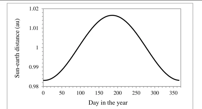
The mean distance between the sun and the earth is approximately equal to 1.496 108 km, exactly 149 597 870 700 m according to the decision of the International Astronomical Union in 2012. This distance is called 1 astronomical unit. Its unit is ua or au, the latter being the recommendation made in 2012 by the International Astronomical Union. The distance between the sun and the earth varies within a year (Figure 3.1), from a minimum of 0.983 au reached approximately on 2-5 January to a maximum of 1.017 au reached approximately on 2-5 July. The exact dates depend on the year.
A consequence of the large distance between the sun and the earth is that despite its formidable size, the sun appears as a small spot to an observer on the earth. The solid angle under which the sun appears is equal to 0.68 10-4 sr. Differently written, the apparent diameter of the sun is approximately 32 ± 0.5’ of arc angle, i.e. half a degree.The sunrays can be considered as parallel as they hit the top of the earth atmosphere.
Figure 3.1 shows that the equatorial plane of the earth inclines by 0.4093 rad (23.45°) on the plane containing the earth orbit. In other words, the axis of the earth daily rotation passing by the two poles is inclined by this angle with respect to the orbit plane. This angle is also called the obliquity of the ecliptic.
Because of this inclination, the northern hemisphere is farther from the sun than is the southern hemisphere in December. Conversely, the northern hemisphere is closer to the sun than is the southern hemisphere in July. As it can be seen in Figure 3.1, the direction of the solar rays is not always parallel to the equatorial plane. The angle composed by the direction to the sun and the equatorial plane is called the solar declination, represented by in Figure 3.1. The winter and summer solstices are defined as the two points in the earth orbit of the maximum
1 Perrin de Brichambaut Ch., Vauge Ch., 1982. Le Gisement Solaire. Published by Technique et Documentation (Lavoisier),
solar declination in absolute value. The solstices define the beginning of two seasons, respectively the astronomical winter which begins on 20-22 December and the astronomical summer which begins on 20-22 June.
The beginnings of the two other astronomical seasons are determined by the equinoxes that are the two points in earth orbit where is equal to 0. The astronomical spring begins about 19-21 March and the astronomical autumn about 21-24 September. Each astronomical season lasts three months, with a variable number of days. On earth, these astronomical seasons have different names for each hemisphere: the boreal (north hemisphere) and austral (south hemisphere) seasons. For example, the astronomical summer corresponds to the boreal summer in the northern hemisphere, and to the austral winter in the southern hemisphere; see Table 3.1 for correspondence. These seasons differ from the meteorological seasons.
Astronomical season Period (approximate) Season in the northern hemisphere
Season in the southern hemisphere Spring 20 Mar – 21 Jun Boreal spring Austral autumn Summer 21 Jun – 23 Sep Boreal summer Austral winter Autumn 23 Sep – 21 Dec Boreal autumn Austral spring Winter 21 Dec – 20 Mar Boreal winter Austral summer
Table 3.1. Correspondence between astronomical, boreal and austral seasons
3.1.1
T
HES
UN-E
ARTHD
ISTANCEThe mean distance between the earth and the sun, r0, is 1 au (Figure 3.1). This value is reached for spring and autumn equinoxes. The actual distance varies during the year. A number of mathematical expressions of this distance are available; they are usually expressed in terms of Fourier series type of expansion. In the following expression adopted from the European Solar Radiation Atlas2, the actual distance r is a function of the number of the day in the year, d. d ranges from 1 (1st January) to 365, or 366 in case of a leap year. It is convenient to define the day angle j:
j = d 2 / 365.2422 (3-1)
j is expressed in rad. It is almost null on 1st January (0.0172), and is equal to (180°) on 1st July and 2 (360°) on 31st December.
The ratio (r0/r) is equal to:
𝑟0/𝑟 = √(1 + 𝜀) (3-2)
where is given by:
≈ 0.03344 cos(j - 0.049) (3-3)
with an accuracy sufficient for many applications. varies between 0.97 et 1.03. Figure 3.2 exhibits the sun-earth distance as a function of the day in the year. The maximum is 1.017 au and is reached between 3-5 July. This moment is called aphelion. The smallest distance is 0.983 au and is reached between 2-5 January (perihelion). The exact dates vary slightly depending on the year. The variation of distance exhibits a relative amplitude of 3.4 %. This seems weak, but it should not be neglected because the radiation received by the earth varies with the square of the sun-earth distance.
2 Greif, J. J., Scharmer, K., Aguiar, R., Albuisson, M., Beyer, H.-G., Borisenkov, E. P., Bourges, B., Czeplak, G., Lund, H.,
Joukoff, A., Page, J. K., Terzenbach, U. and Wald, L., 2000. European Solar Radiation Atlas. Vol. 2: Database and Exploitation Software. Published for the Commission of the European Communities by Les Presses de l'Ecole, Ecole des Mines de Paris, France, 290 pp. [This book contains equations describing the sun position with respect to an observer can be found. Several models for converting global horizontal irradiance into diffuse and direct irradiances on an inclined plane surface are described. Equations in C are available at www.oie.mines-paristech.fr/Valorisation/Outils/Solar-Geometry/]
12 BASICS IN SOLAR RADIATION AT EARTH SURFACE
Figure 3.2. Sun-earth distance in au as a function of the day in the year
3.1.2
S
OLARD
ECLINATIONAs already written, the solar declination is the angle made by the line joining the sun to the earth and the equatorial plane (Figure 3.1). The convention for counting the solar declination is the same as that for latitudes. Here the ISO 19115 convention is adopted3. Latitudes are counted positive in the northern hemisphere and negative in the southern hemisphere. Longitudes are counted positive east of the meridian 0° and negative west of this meridian. Latitudes and longitudes are angles; they are usually expressed in degrees.
is the greatest for the summer solstice and is equal to +0.4093 rad (23.45°). It reaches its minimum for the winter solstice and is equal to -0.4093 rad (-23.45°). By definition, is equal to 0 for the equinoxes. is a function of the longitude . A mean daily value is accurate enough for many applications. The European Solar Radiation Atlas proposes a series of equations for computing the sun-earth geometry and the angles depicting the course of the sun in the sky as seen by an observer at earth surface. Accuracy in time is of order of a few minutes and these equations are suitable if one is focusing on hourly or daily sums of solar radiation. For a greater accuracy, other works should be preferred45.
Using the European Solar Radiation Atlas equations, can be computed from d, and the year y. Let n0 represent the spring-equinox time expressed in days from the beginning of the year, i.e. the time in decimal day that elapses from 0.0 h on 1st January to the spring equinox at longitude 0° in the year y. Let tday represent the
3 ISO 19115-1:2014. Geographic information -- Metadata -- Part 1: Fundamentals, 167 pp, International Standards Organization, Geneva, Switzerland, 2014.
4 Reda, I., Andreas, A., 2004. Solar position algorithm for solar radiation applications: Solar Energy, 76(5), 577–589. Corrigendum, 81, 838-838, 2007. [It describes solar position algorithm, called SPA. The uncertainty, in terms of standard deviation of solar azimuth and zenithal angles is stated to be within 5 µrad (0.0003 °, or 1'') for a very large period from -2000 to 6000. Libraries in C, Matlab and Python that implement the SPA algorithm are available (respectively at: rredc.nrel.gov/solar/codesandalgorithms/spa, www.mathworks.com/matlabcentral/fileexchange/4605 and www.pysolar.org).] 5 Blanc P., Wald L., 2012. The SG2 algorithm for a fast and accurate computation of the position of the Sun. Solar Energy, 86, 3072-3083. [This algorithm SG2 is very fast. Maximum error is of order of 10'', for a multi-decadal time period. Equations in C and Matlab are available at http://www.oie.mines-paristech.fr/Valorisation/Outils/Solar-Geometry/]
0.98
0.99
1
1.01
1.02
0
50
100
150
200
250
300
350
Su
n
-eart
h
d
is
tance
(au
)
time, in days, from the spring equinox and day the day angle counted from the spring equinox. If INT denotes the integer part of an expression, i.e., the left part before the decimal, these quantities are given by:
n0 = 78.8946 + 0.2422 (y - 1957) - INT[(y - 1957)/4] (3-4)
tday = -0.5 - / (2 ) - n0 (3-5)
day = (2 / 365.2422) (d + tday) (3-6)
The declination is then given by:
b1 + b2 sin(day) + b3 sin(2day) + b4 sin(3day) + b5 cos(day) + b6 cos(2day) + b7 cos(3day) (3-7) where:
b1 = 0.0064979, b2 = 0.4059059, b3 = 0.0020054, b4 = −0.0029880 b5 = −0.0132296, b6 = 0.0063809, b7 = 0.0003508
Figure 3.3 displays the variation of the solar declination as a function of the number of the day in the year for longitude 0° and for the year 2006. The declination is 0 rad for days 80 (21 March) and 266 (22 September), minimum (-0.4093 rad, -23.45°) for day 356 (22 December) and maximum (+0.4093 rad, +23.45°) for day 172 (21 June).
Neglecting the longitude, i.e., making the calculations by setting to 0° in Eq. 3-5, induces an error in the solar declination that is less than 0.001 rad in absolute value. Such an error is acceptable in solar engineering calculations; the influence of the longitude can be neglected.
Figure 3.3. Solar declination (in rad) and its variation throughout the year. The year is 2006. Longitude is 0°.
3.1.3
G
EOCENTRIC ANDG
EOGRAPHICC
OORDINATESThe equations are given here with the geocentric coordinates, i.e., by considering the earth as a perfect sphere. These geocentric coordinates are the latitude c and the longitude . The earth is not a perfect sphere and is slightly elongated in the equatorial plane. The radius to the poles Rpole is equal to 6 356.752 km, and is slightly less than the radius at Equator Requator which is 6 378.137 km.
-30
-20
-10
0
10
20
30
-0.5
-0.4
-0.3
-0.2
-0.1
0
0.1
0.2
0.3
0.4
0.5
0
50
100
150
200
250
300
350
So
lar
d
ecl
in
at
io
n
(d
eg
ree)
So
lar
d
ecl
in
at
io
n
(rad
)
14 BASICS IN SOLAR RADIATION AT EARTH SURFACE
Accordingly, there is a difference between the geocentric latitude c and the actual geographic latitude . The relationship between both is:
tanc = (Rpole / Requator)² tan (3-8)
Because (Rpole / Requator) is less than 1, tanc is less than tan; c is closer to the equator than is the actual latitude . The difference between these angles is null at the poles and the equator and maximum at geographic mid-latitudes /4 (45°) and -/4 (-45°), where it reaches 0.0033 rad (0.19°).
As a first approximation, the perimeter of the earth P along a longitude is
P = 2 [(Rpole + Requator)/2] (3-9)
The mean distance on the earth surface corresponding to 1° in latitude is equal to P/360°, i.e. 111 km. Hence, the maximum error of 0.19° corresponds to an error in the north-south distance of approximately 21 km ( 0.19*111 km). If this effect is to be taken into account, the geographic latitude should be replaced in all
equations by the geocentric latitude c.
3.2
T
HES
UNG
EOMETRYP
ERCEIVED BY ANO
BSERVERFrom the point of view of an observer at ground level, the relative movements of the sun and earth are not perceived as described above. For this observer, the sun describes a course in the sky from east to west. The exact course depends upon the season and may be described by two angles: the solar zenithal angle and the solar azimuthal angle, or azimuth (Figure 3.4).
Figure 3.4. The various angles describing the position of the sun in the sky viewed from an observer OS is the solar zenithal angle, S is the solar elevation angle and S is the azimuth. N, E, S, and W denote respectively the north, east, south and west.
It should be noted that the atmosphere does not affect the perceived direction of the sun, except when the sun is very low on or below the horizon. Hence, the solar zenithal angle and the azimuth are the same at earth surface or at the top of the atmosphere and more generally for any altitude.
The solar zenithal angle S is the angle formed by the direction of the sun and the local vertical (zenith). The solar elevation angle S is the angle formed by the direction of the sun and the horizon. One is the complementary of the other, that is:
In the following, the angle S is mostly used in equations. To replace S by S, the following relationships may be used:
cosSsinS (3-11)
sinScosS (3-12)
During daytime, the solar elevation angle S varies from 0 when the sun is at the horizon to when the sun is at its highest, i.e. at zenith. For more accuracy when the sun is low, i.e., when S is less than 10°, one should take into account the atmospheric refraction of the solar rays. The angular difference between the geometric elevation and the apparent elevation is 0.01454 rad (0.8333°, i.e. 50’); the sun appears lower than its actual position. This effect may be neglected for most cases, except for high latitudes.
It is very convenient to define the hour angle of the sun to describe its apparent movement. This angle is the arc angle comprised between the longitudinal plane of the point of interest O and the instantaneous position of the sun (Figure 3.5). In other words, it is the arc of trajectory of the sun counted from noon. is 0 when the sun is at its highest. is counted negative in the morning and positive in the afternoon.
Figure 3.5. Scheme showing the hour angle of the sun for the observer O. ss is the hour angle for sunset, sr is that of sunrise (ss = -sr). Adapted from Perrin de Brichambaut and Vauge (1982, op. cited).
The true solar time (TST) is defined by the fact that it is 12:00 when the sun is at its highest for the day under concern, i.e. for =0. This highest position is called solar noon. Since the apparent trajectory of the sun during a day, from - to +, i.e. is uniformly described by in 24 h, is related to the true solar time tTST (expressed in h) by:
= (2 / 24) (tTST - 12) = ( / 12) (tTST - 12) (3-13)
since the sun path of 2 is uniformly described in 24 h. Reciprocally, given , tTST is given (in h) by:
tTST = 12 (1 + / ) (3-14)
The solar zenithal angle S for a given tTST is obtained by:
cosS = sinsin coscos cos (3-15)
where is given by Eq. 3-13, is the latitude and the solar declination.
The azimuth of the sun S, or solar azimuthal angle, is defined as the angle between the projection of the direction of the sun on the horizontal plane and a reference direction (Figure 3.4). There are several conventions for measuring S. The simplest is to count S clockwise from north where its value is 0. Thus, it is /2 (90°) for east, (180°) for south and 3/2 (270°) for west. This convention is that recommended by the international
16 BASICS IN SOLAR RADIATION AT EARTH SURFACE
organization for standardization ISO in geographic information (ISO 19115) and is used in this text. The following equations link S and S:
sinS sinS = - cos sin (3-16)
cosS sinS = sin cos- cos sin cos
If S is different from 0 and if the latitude is different from ∕2, the solar azimuth S is given by the following equations:
cos’ = [sin cos - cos sin cos] ∕ sinS (3-17)
if sin ≤ 0, then S = cos-1(cos’’) if sin > 0, then S = 2 - cos-1(cos’)
The following equations may have an interest in further calculations implying the solar azimuthal angle:
sinS= -cos sin / sinS (3-18)
tanS= -sin / [sin cos - cos tan] in northern hemisphere tanS= sin / [sin cos - cos tan] in southern hemisphere
These equations stand provided that S is not equal to 0 and not at the pole ( = /2). When S is null, the azimuth is undetermined; it may be set to , i.e. to the south. At the poles, S is undetermined for any position of the sun; it may be set to any value.
Several solar engineering publications have adopted another convention: the solar azimuth is measured from due south in the northern hemisphere and is positive towards the west. In this way, it behaves similarly to the solar hour angle : it is positive in the afternoon (west) and negative in the morning (east). Thus, the solar azimuth for solar engineers is equal to 0 to the south, /2 to the west, to the north and -/2 to the east. In the southern hemisphere, the solar azimuth for solar engineers is counted from due north and still positive to the west. Thus, it is equal to 0 in the north, /2 to the west, to the south and -/2 to the east. With this convention, the solar azimuth for solar engineers is equal to (S - ) in the northern hemisphere and (-S) in the southern hemisphere where S is defined by Eq. 3-17 with the ISO convention.
Figure 3.6. The inclination (or tilt) angle and the azimuth describe the inclined plane. is the incidence angle and is comprised between the normal to plane and the solar rays.
An inclined plane can be described with two angles: the inclination angle , also called the tilt angle, and the azimuth (Figure 3.6). The inclination angle varies from 0 (horizontal plane) to /2 (vertical plane). The azimuth of a plane is defined as the angle between the projection of the normal to this plane on the horizontal
plane and a reference direction. It is also called orientation or aspect in the case of natural slopes. The convention for the azimuth should be the same as for the solar azimuth S.
Assume a solar engineer who has adopted the convention described above: the solar azimuth is measured from due south in the northern hemisphere and is positive towards the west. Then if the solar engineer describes the orientation of a photovoltaic panel (PV) as being 62°, i.e. the panel is orientated towards south-west, the azimuth is 242° (=180°+62°) in the ISO convention. If the orientation of the PV panel is -118°, i.e. the panel is orientated towards north-east, then it is 62° (=180°-118°) in the ISO convention. If the PV panel is located in the southern hemisphere with an orientation of 62°, i.e. the panel is orientated towards north-west, the orientation is 298° (=360°-62°) in the ISO convention. If the orientation of the PV panel is -118°, i.e. the panel is orientated towards south-east, the orientation is 118° in the ISO convention.
The angle of incidence of the solar rays is the angle formed by the normal to the plane and the rays (Figure 3.6). It is given by:
cos = cos cosS + sin sinS cos(S- ) (3-19)
This equation and the following ones are valid whatever the convention for counting the azimuth.
For further calculations, it is convenient to express as an explicit function of . It will ease the computation of the radiation received by an inclined surface. By exploiting Eqs 3-15 to 3-19 and given that
cos(S - ) = cosS cos + sinS sin (3-20) we obtain
cos = A cos + B sin + C (3-21)
where
A = cos (cos cos- sin sin cos)
B = -cos sin sin (3-22)
C = sin (sin cos + cos sin cos)
The integral of cos during any period of time [t1, t2] expressed by the hour angles 1 and 2, may be computed using Eqs 3-21 and 3-22:
∫𝜔2𝑐𝑜𝑠 𝜃 𝑑𝜔
𝜔1 =[𝐴 𝑠𝑖𝑛𝜔 - 𝐵 𝑐𝑜𝑠𝜔 + 𝐶𝜔]𝜔1
𝜔2
(3-23) = A (sin2- sin1) - B (cos2- cos1) + C (2- 1)
If the plane is horizontal ( = 0), then
A = cos cos
B = 0 (3-24)
C = sin sin
and the integral of cosS is: ∫ 𝑐𝑜𝑠 𝜃𝑆 𝑑𝜔
𝜔2
𝜔1 = [𝐴 𝑠𝑖𝑛𝜔 + 𝐶𝜔]𝜔1
𝜔2= A (sin
In summary
Time is an essential element in solar radiation. It should be known with care. Its encoding in data exchange should follow ISO standards.
The daily rotation of the earth on itself induces the notion of a mean solar day divided into 24 h of 60 min each. The time defined in this way is called the mean solar time (MST). The sun is approximately at its zenith when the mean solar time is equal to 12:00. Consequently, the mean solar time is not the same everywhere on the earth. It depends upon the longitude. A difference of 1 h corresponds to a difference of 15° in longitude.
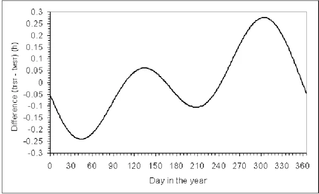
The difference between the true solar time and the mean solar time is as a function of the day in the year. The maximum is reached on 31st October: the difference is equal to 0.276 h (17 min). The minimum is -0.242 h (15 min) on 13th February.
The reference for time is the mean solar time for the longitude 0°; it is called the Universal Time, abbreviated in UT. The legal time is the time used legally in a given country. It is also called local time, standard time, civil time or local clock time.
The daily rotation of the earth on itself determines daytime and night-time. Daytime is the duration of the day during which the sun is above the horizon, i.e. the period of time between the sunrise and the sunset. The night-time is the period of night-time comprised during the sunset and the sunrise when the sun is below the horizon. The duration of a day is 24 h; the sum of the durations of daytime and night-time is equal to 24 h.
The astronomical daytime is defined as the period of time between the sunrise and the sunset in the case there is no obstruction in the line of sight. If obstructions are present such as in cities or in case of marked relief, the actual daytime may differ from the astronomical daytime.
The sun-earth geometry has for long served as standards for defining time and its units. For the time being, the second is defined by electronic transitions in certain atoms in atomic clocks. The second is the international unit of time. Time is primordial for computing the sun-earth geometry and subsequently the solar radiation at the top of the atmosphere and at earth surface.
4.1
T
HET
RUES
OLART
IME,
M
EANS
OLART
IME,
U
NIVERSALT
IME ANDL
EGALT
IME4.1.1
T
HEM
EANS
OLART
IME ANDT
RUES
OLART
IMEA day is the time duration for one rotation; a day is divided into 24 h, i.e. 24 times 3600 s, as an average. The time defined in this way is called the mean solar time (MST), noted tMST. The sun is approximately at its zenith when the mean solar time is equal to 12:00. Consequently, the mean solar time is not the same everywhere on the earth. It depends upon the longitude.
One hour corresponds to an angle of (2/24) (=15°), because the earth rotates 2 in 24 h. This is equivalent to saying that 1° in longitude corresponds to 4 min. Consequently, the difference in time between longitude 0 and longitude is given by (24 / 2), expressed in h:
tMST() = tMST(=0) + (24 / 2) (4-1)
Because the orbit of the earth is an ellipse, the earth angular speed varies slightly throughout the year. Combined with the rotation of the earth on itself, which is very regular, it results that the sun does not reach its highest position in the sky at 12:00 MST every day. The time of solar noon may differ from 12:00 MST by up to 17 min. The time determined every day by the actual position of the sun in the sky is called true solar time (TST), or local apparent time; it is represented by tTST. It is important not to confuse this local apparent time with the legal local time. Solar noon is reached at 12:00 TST. The difference between tTST and tMST is sometimes called time equation; it is expressed in h and can be approximated by:
20 BASICS IN SOLAR RADIATION AT EARTH SURFACE
Figure 4.1 displays the variation of the difference between tTST and tMST as a function of the day in the year. The maximum is reached on 31st October: the difference is equal to 0.276 h (17 min). The minimum is equal to -0.242 h on 13th February. The difference is equal to 0 for days 16th April, 14th June, 31st August and 25th December. One notes a secondary maximum of 0.061 h (4 min) on 14th May and a secondary minimum of -0.106 h (6 min) on 27th July.
Figure 4.1. Difference between times in TST and MST as a function of the day in the year (tTST- tMST)
4.1.2
T
HEU
NIVERSALT
IME ANDL
EGALT
IMEOne hour corresponds to an angle of (2/24) in radian (=15°), because the earth rotates 2 in 24 h. This is equivalent to saying that 1° in longitude corresponds to 4 min. The earth is divided into 24 time zones; each differs from the other by adding 1 h eastwards. The width of each time zone is 15° in longitude. Consequently, the difference in time between longitude 0° and longitude , expressed in rad, is given by (24 / 2) h. If is expressed in degrees, then the difference in time is (24 / 360) h.
The reference for time is the mean solar time for the longitude 0°; it is called the Universal Time, abbreviated UT and represented by tUT. More exactly, the time standard is the Coordinated Universal Time, abbreviated UTC. It is the basis of legal time and is derived from International Atomic Time. The difference between UT and UTC is slight, approximately 1 s per day. Hence, the UT time is adopted here.
Given a time tUT and a location of longitude , the mean solar time tMST is given in h by:
tMST = tUT + (24 / 2) if is in rad or = tUT + (24 / ) if is in degree (4-3) At longitude 0°, the mean solar time is equal to the Universal Time. At longitude 180°, it is equal to the Universal Time plus 12 h, and at longitude 120°, it is equal to the Universal Time plus 8 h.
The legal time, tlegal, is the time used legally in a given country. It is often called local time by the general public. Other terms are standard time, civil time and local clock time. The legal time at a given location is quite often the time of the time zone containing this location. However, the reality is more complex and is illustrated by a few examples below.
Brazil is comprised approximately between the longitudes -35° and -73°. The mean solar times at each extreme longitude are respectively tUT-2.3 h and tUT-4.9 h. The legal time has been set to tUT-3 h for the whole country,
which corresponds to the longitude -45°. It could have been separated in two or three time zones. Russia spans approximately from 30° to 190° in longitude and is separated in eight time zones.
China spans approximately from 75° to 135° in longitude. The mean solar times at each extreme longitude are respectively tUT+5 h and tUT+9 h. It could have been separated in several time zones. The legal time has been set the same over the whole China and is tUT+8 h, i.e. approximately the mean solar time at Beijing whose longitude is 116.36°. In this case, there may be considerable differences between the legal time and the mean solar time. Assume a legal time of 12.5 h. The corresponding UT time is tUT = (12.5 – 8) h = 4.5 h. According to Eq. 4-3, the mean solar time is 12.26 h. The city of Chengdu, China is located more to the West, with a longitude of 104.06°. Though the legal time is the same as in Beijing, i.e. 12.5 h, the mean solar time at Chengdu is 11.44 h; it is equal to 10.34 h for the city of Urumqi whose longitude is 87.62°.
The Westernmost Africa countries such as Mauritania or Senegal could have adopted tUT+1 h as the legal time given their longitudes. The legal time was set to UT instead. On the opposite, the Iberian Peninsula (Portugal and Spain) exhibits the same longitudes than Ireland and the United Kingdom. While Portugal, Ireland and the United Kingdom share the same time zone, Spain is 1 h ahead.
Several countries from mid- to high latitudes have adopted daylight saving time, which is usually one hour ahead with respect to the time zone during the local summer time. For example, legal time in Western Europe is equal to UTC+1 h, except in summer, when 1 h is added. To add to the complexity of handling legal time with respect to the UTC time, the dates of change for daylight saving time are not the same throughout the world.
Detailed information on time zone is easily found on the Web and is of great help in understanding and handling the time that is associated to a measure for example.
In summary, if one needs to compute the position of the sun for a given location at a given time, one must know accurately the true solar time. If the time is given in legal time, the following operations must be performed:
convert the legal time for the location under concern into UT time tUT, by taking into account the time zone and possibly the daylight saving time,
then, apply Eq. 4-3 to obtain tMST,
then, apply Eq. 4-2 to obtain tTST,
then, use equations of the previous Chapter to compute the solar angles.
4.2
S
UNRISE,
S
UNSET ANDD
AYTIMEThe daily rotation of the earth on itself determines daytime and night-time. Daytime is the duration of the day during which the sun is above the horizon, i.e. the period of time between the sunrise and the sunset. The night-time is the period of night-time comprised during the sunset and the sunrise when the sun is below the horizon. The duration of a day is 24 h; the sum of the durations of daytime and night-time is equal to 24 h.
The astronomical daytime is defined as the period of time between the sunrise and the sunset in the case there is no obstruction in the line of sight. If obstructions are present such as in cities or in case of marked relief, the actual daytime may differ from the astronomical daytime.
4.2.1
T
HES
UNRISE ANDS
UNSETRemember that the hour angle is 0 rad when the sun is at its highest, i.e. when tTST =12 h. is counted negative in the morning and positive in the afternoon. The hour angles for sunrise (SR, negative) and sunset (SS, positive with SS = -SR) define the daytime. The following relationship holds (Eq. 3-14):
tTST = 12 (1 + / ) (3-14)
where is in rad and tTST in h. The sunset hour angle, SS, is calculated by setting the solar zenithal angle S to
/2 in Eq. 3-15 provided there is no obstruction:
cosS = sinsin coscos cos (3-15)
22 BASICS IN SOLAR RADIATION AT EARTH SURFACE
if = /2, if > 0 SS = , otherwise SS = 0 if = -/2, if > 0 SS = 0, otherwise SS =
if (-tan tan 1SS = 0 (4-4)
if (-tan tan-1SS = otherwiseSS = arccos(-tan tan
SS = 0 means that the sun is always below the horizon; SS = means that the sun is always above the horizon. The sunrise hour angle, SR, is calculated from SS by:
SR = -SS (4-5)
The azimuth for sunrise SR, respectively sunset SS, is computed by means of Eq. 3-17 where S is set to /2.
SR is less than , while SS is greater than .
The true solar times for sunrise tSR and sunset tSS are given in h by:
tSR = 12 (1 + SR / ) (4-6)
tSS = 12 (1 + SS / )
SS is always equal to 2 at the equator: the sunrise and sunset occur at the same time every day: tSR is equal to 6 h and tSS to 18 h. SS is equal to 2 on 21 March and 23 September for all latitudes, except the poles. On these days, tSR is equal to 6 h and tSS to 18 h for any latitude.
At the North Pole SS is equal to 0 during a period of six months centred on the winter solstice, i.e. around 22 December: the sun is always below the horizon. SS is equal to during the other six months centred around 21 June: the sun is always above the horizon. It is the opposite at the South Pole.
The polar circles are particular latitudes with respect to the sunrise and sunset and hence daytime. North of the northern polar circle, there is at least one day per year for which SS is , i.e. the sun is always above the horizon, and reciprocally at least one day per year for which SS is 0, i.e., the sun is always below the horizon. The period during which SS = is centred around 21 June and that during which SS = 0 is centred around 22 December. It is the opposite for the southern hemisphere. The latitudes of these polar circles are the complement to 2 of the inclination angle (0.4093 rad, i.e. 23.45°) of the axis of the daily rotation of the earth on the orbit plane (Figure 3.1) and are equal to 1.1615 rad (+66.55°) for the northern polar circle and -1.1615 rad (-66.55°) for the southern polar circle.
There is no allowance for atmospheric refraction or angular size of the solar disc in the above equations. If these effects are to be taken into account, then the sunset hour angle SS is now the solution of the equation below:
sin (-0.014544) = sinsin coscos cosSS (4-7)
as the edge of the solar disk just appears, or disappears, on the horizon at sunrise, or sunset, when the solar elevation angle S is 0.0145 rad (0.8333°). The sunrise hour angle is computed by Eq. 4-5. These effects may be neglected as a first approximation.
If one considers obstructions of the horizon, such as mountains, buildings or vegetation, the sunset and sunrise hour angles will correspond to a solar elevation angle greater than 0, or greater than -0.01454 rad if one considers the atmospheric refraction and the size of the solar disk. Assuming that the solar elevation angles for such an obstructed site are known and are noted SR at sunrise and SS at sunset, then the hour angles for sunrise
SR and sunset SS are the solutions of the following equations: coscos cos(-SR) = sinSR - sinsin (4-8)
4.2.2
T
HED
AYTIMEThe daytime Sday is given in h by:
Sday = (tSS- tSR) = (12 / ) (SS- SR) (4-9)
If obstructions are not taken into account, then (SR = -SS). In this case, the daytime is also called the astronomical daytime and is noted S0. It is given in h by:
S0 = (24 SS / ) (4-10)
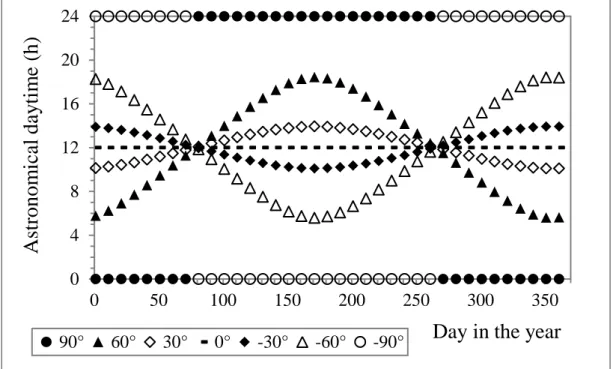
Figure 4.2 reports the astronomical daytime S0 as a function of the day of the year for various latitudes. Note that the shapes of variations in S0 are the same than those in SS since S0 is equal to SS multiplied by a constant (Eq. 4-10). S0 is always 12 h at the equator. For the days 21 March and 23 September, S0 is equal to 12 h for all latitudes, except the poles. Outside the equatorial belt, S0 changes considerably according to the time of year and latitude. For the northern hemisphere, the daytime is greater from April to September than from October to March. On the contrary, in the southern hemisphere, S0 is greater from October to March than from April to September. At any latitude in northern hemisphere, except equator, the daytime is the greatest at the summer solstice and the smallest at the winter solstice. This is opposite in the southern hemisphere, the daytime is the smallest at the summer solstice and the greatest at the winter solstice.
Figure 4.2. The astronomical daytime S0 as a function of the day in the year and latitude.
At the poles, daytime is either 24 h or 0 h. The sun is always above the horizon during the six months centred around the summer solstice –the famous midnight sun- and always below the horizon during the six months centred around the winter solstice –the polar night.- The midnight sun –and reciprocally the polar night– can be experienced for latitudes north of the northern polar circle or south of the southern polar circle.
At the North Pole SS is equal to 0 during a period of six months centred on the winter solstice, i.e. around 22 December: the sun is always below the horizon. SS is equal to during the other six months centred around 21 June: the sun is always above the horizon. It is the opposite at the South Pole.
Table 4.1 reports on the yearly mean of the astronomical daytime at various latitudes. At the equator, the mean is 12 h. The dissymmetry between the northern and southern hemispheres can be noted: the mean duration of the day is greater in the north than in the south. The mean reaches its maximum (12.30 h) at the North Pole; it
0
4
8
12
16
20
24
0
50
100
150
200
250
300
350
A
st
ro
n
o
m
ical
d
ay
ti
m
e
(h
)
Day in the year
24 BASICS IN SOLAR RADIATION AT EARTH SURFACE
decreases towards the South Pole where it reaches a minimum of 11.70 h. The difference between these minimum and maximum is 0.6 h.
Latitude Astronomical daytime (h) Latitude Astronomical daytime (h)
90° 12.30 -90° 11.70 70° 12.20 -70° 11.80 60° 12.11 -60° 11.89 45° 12.06 -45° 11.94 30° 12.03 -30° 11.97 0° 12.00
Table 4.1. The yearly mean of the astronomical daytime S0 for various latitudes
4.3
E
NCODINGT
IME INISO
F
ORMATAs already stated, time is an essential element in solar radiation. Its encoding for exchange of data is crucial. There are several numeric representations of dates and time in different countries or different domains of activities. The purpose of an international standard is to avoid confusion and the misinterpretation. The authors have adopted the ISO format on time6 and strongly recommend it.
The ISO format is applicable when dates are given in the Gregorian calendar and times in the 24-h system. It includes
calendar dates expressed in terms of calendar year, calendar month and calendar day of the month;
ordinal dates expressed in terms of calendar year and calendar day of the year;
week dates expressed in terms of calendar year, calendar week number and calendar day of the week;
local time based upon the 24-h timekeeping system;
Coordinated Universal Time (UTC) of day;
local time and the difference from UTC;
combination of date and time of day;
time intervals;
recurring time intervals.
There are two types of format: one with separators and one without separators. Only the latter is dealt with as it allows handling the many cases that are encountered when exchanging information on solar radiation. The standard may appear complicated as it has been designed for interchange between machines. Several popular computer languages offer libraries that cope with this ISO standard, such as datetime for Python.
4.3.1
E
NCODINGD
ATES ANDW
EEKSThe encoding of a date is YYYY-MM-DD, where the year YYYY is given with four characters, the month MM is encoded from 01 (January) to 12 (December) with two characters, and the day DD is the day in the month, from 00 up to 31 with two characters. For example,
31 October 2017 is encoded as 2017-10-31;
2 May 2017 is encoded 2017-05-02. Reduced representations are allowed. For example,
2017 alone means the year 2017 without specifying a specific day in this year;
2017-10 means October 2017 without specifying a specific day in this month.
6 ISO 8601:2004(E) Data elements and interchange formats – Information interchange – Representation of dates and times,
2014, Third edition, 40 p., International Standard Organization, Geneva, Switzerland. [ISO 8601 specifies numeric representations of date and time.]
One may need to express the date with the year YYYY and the number of the day in the year DDD. In this case,
DDD is encoded with three characters and ranges from 001 to 365 or 366 in case of a leap year. For example,
2017-122 corresponds to 2 May 2017.
A week, or calendar week, is defined as the time interval of seven days starting with a Monday. The week number is the ordinal number which identifies a week within the year according to the rule that the first calendar week of a year is that one which includes the first Thursday of that year and that the last calendar week of a year is the week immediately preceding the first calendar week of the next year. In the encoding of a week, the week number ww is encoded with two characters starting from 01: YYYY-Www. For example,
2017-W03 means the third week of 2017 without specifying a specific day in this week;
2017-W01 denotes the first week of 2017 and starts on Monday 2 January. The 1st January 2017 was a Sunday and belongs to the week #52 of 2016.
If one wants to specify a day in the week, one may use the following encoding YYYY-Www-d where d is the number of the day in the week, starting from 1 (Monday) up to 7 (Sunday). For example,
2017-W03-3 means Wednesday of the third week of 2017, i.e. Wednesday 18 January 2017.
2017-W18-2 means Tuesday of the eighteenth week of 2017, i.e. Tuesday 2 May 2017.
4.3.2
E
NCODINGT
IMEThe encoding of a time is hh:mm:ss, where the hour hh ranges from 00 to 24, encoded with two characters, the minutes mm are encoded from 00 to 60 with two characters, and the seconds are encoded from 00 to 60 with two characters. For example,
13:34:21 means 13 h 34 min and 21 s;
13:34:00 means 13 h 34 min and 00 s;
13:34 means 13 h and 34 min irrespective of the number of seconds in this minute.
The standard states that 00:00:00 is the beginning of the day and 24:00:00 is the end of the day. The authors draw attention to the reader that this may not be the case in all implementations of the standard. In some cases, 24:00:00 may mean the beginning of the following day.
Representation of time with decimal fraction is possible. For example;
13:34:21,023 means 13 h 34 min, 21 s and 23 thousandths, if the decimal sign is the comma (preferred sign);
13:34:21.023 means 13 h 34 min, 21 s and 23 thousandths, if the decimal sign is the full stop;
13:34,023 means 13 h 34 min, and 23 thousandths of 1 min;
fractional hour in decimal format is not allowed in this format, i.e. 13,023 (or 13.023) is not permitted. It has been seen that several time systems may be found. The ISO standard accommodates for that. The Z letter indicates the UTC system. For example,
13:34:21 means 13 h 34 min and 21 s in an unspecified time system;
13:34:21Z means 13 h 34 min and 21 s in the UTC system;
13:34Z means 13 h and 34 min in the UTC system irrespective of the number of seconds in this minute. If local time is used, it is possible to indicate the difference between the local time and UTC. The representation of the difference is appended to the representation of the local time. The difference between the time scale of local time and UTC shall be expressed in hours and minutes, or hours only independent of the accuracy of the local time expression. For example,
13:34:21+01:00 means 13 h 34 min and 21 s in the local time system, which is 1 h ahead of UTC;
13:34:21.023+01:00 means 13 h 34 min, 21 s and 23 thousandths in the local time system, which is 1 h ahead of UTC;