HAL Id: dumas-01330852
https://dumas.ccsd.cnrs.fr/dumas-01330852
Submitted on 13 Jun 2016
HAL is a multi-disciplinary open access
archive for the deposit and dissemination of sci-entific research documents, whether they are pub-lished or not. The documents may come from teaching and research institutions in France or abroad, or from public or private research centers.
L’archive ouverte pluridisciplinaire HAL, est destinée au dépôt et à la diffusion de documents scientifiques de niveau recherche, publiés ou non, émanant des établissements d’enseignement et de recherche français ou étrangers, des laboratoires publics ou privés.
Elizabeth Palela
To cite this version:
Elizabeth Palela. The impact of anthropogenic factors on urban wetlands: case of Msimbazi valley Dar-es-Salaam. Geography. 2000. �dumas-01330852�
(FRAtI1812 io: 06 2001
1
CERTIFICATION
The undersigned certifies that she has read and hereby recommends for acceptance by the university of Dar es Salaam the dissertation entitled: The
Impacts of Anthropogenic Factors on Urban Wetlands: A Case of Msimbazi Valley, Dar es Salaam, in partial fulfilment of the requirements for the
degree of Master of Arts (Geography and Environmental Management).
Prof. Misana, S. (SUPERVISOR)
DECLARATION • AND
COPYRIGHT
I, Elizabeth Palela declare that this Dissertation is my oi original work and it has not been presented to any other University for a similar or other degree award.
Signature --- ---
This dissertation is copyright material protected under the Berne convention, the copyright Act 1966 and other international and national enactment, in that behalf, on intellectual property. It may not be reproduced by any means, in full or in part, except for short extracts in fair dealing, for research or private study, critical scholarly review or discourse with an acknowledgement, without written permission of the Director of Postgraduate, Studies, on behalf of both the author and the University of Oar es Salaam.
111
ACKNOWLEDGEMENT
This work is the result of many contributions, large and small, from many individuals, groups and institutions, without whom, it would have been impossible to accomplish such a task. I am deeply indebted to every one for the moral and material support that they gave me throughout this work.
I would, first, like to thank my supervisor Professor Salome Misana of the Geography Department, University of Dar es Salaam, for her tireless guidance, encouragement, advice, challenges, concerns, patience and criticisms during this work. I am also grateful to her for giving me access to her personal computer and printer.
I am greatly indebted to Dr. G. Jambiya, from the Geography Department and Dr. H. Sosovele, from the Institute of Resource Assessment, University of Dar es Salaam, for their support, encouragement and discussions during this work. Thanks to Dr. Jambiya for guiding and assisting me with complex formats, drawings, diagrams and Tables.
I thank the Head of the Geography Department, Professor M. Mbonile, for the understanding, encouragement and faith in me. I am truly grateful to him for giving 4/
- me access to his laptop. Mr. D. Sabai, warrants special appreciation for the tireless work with collection of data, advice, hard work and devotion to quality fieldwork. He was always willing to go back for that little detail that was left out, without complaints and I greatly appreciate that. On the technical side, many thanks to the Surveys and Mapping Division and specifically Mr. Mshana who helped in
the interpretation and plotting of aerial photos. Likewise thanks to Ms. Mushi, Anna of TANRIC, for her assistance in digitising and analysing the study area maps. I would like to thank the cartographers, Messrs Mahuwi and Ngowi of the Cartographic Unit, Geography Department for their advice on map presentations and Mr. Mkanta of the statistics department for data processing.
Special thanks go to the staff of the Sustainable Dar es Salaam Program (SDP), namely, Messers. Mwalukasa and Maira, for their assistance in providing me with the necessary information on the Msimbazi wetland area,. NEMC library personnel (Ms. Cessy and Zafarani) who assisted in accessing information concerning wetlands. I appreciate the cooperation from Messrs. Muheto, Chisara, and Nzali for sparing time to interview them. I wish to acknowledge the WWF country office for giving me access to their library.
I wish to acknowledge the assistance from all Government officials at regional, district, and ward and ten cell levels, for facilitating this study to take place in their areas. Not giving thanks to all the respondents who were part of the study would be unfair. I, therefore, thank them a lot.
Many thanks go to my graduate student peer, Mr. Anthony Donald, who was always ready to discuss and share ideas with me. His contribution and support is appreciated very much.
I would also like to convey my thanks to S[DA/SAREC for sponsoring me financially throughout the course. Thanks to the Geography Department staff, in general, for assisting me through their experiences, ideas and opinions, which
V
enriched this work.
Very special appreciation to my best friend, Beatrice Mchome (Ms), for her enduring moral support, especially during difficult times. She was always ready to assist, advise and encourage. Many thanks to her and her family.
Chenduta and Alvin deserve most of the appreciation for their love, inspiration, encouragement, moral support, patience, understanding and sacrifice. Chenduta was willing to sacrifice time to assist me in my work and I am very grateful for that. Finally, I extend special appreciation to my parents and relatives for their encouragement and support.
DEDICATION
To
The three men in my life:
My beloved father, Bernard B. Palela,
My loving husband, Chenduta Makawa, and
vii
ABSTRACT
Most of Tanzania's urban wetlands are used as wastelands or hazard lands; they are neglected. This negative outlook towards urban wetlands manifests itself in the misuse, mismanagement, degradation and loss of these fragile ecosystems.
Poor economic conditions in the rural areas resulting from policy inadequacies and lack of support to agriculture stimulate migration towards urban centres. This is contributing to rapid urban population growth and overcrowding .A growing number of migrants are settling in or near wetlands, because they can not afford "proper and standard housing". They also do not have access to land and planned areas. There is also the urge for close proximity to the city centre and access to a range of urban services.
As a result, the urban wetlands are being degraded through erosion, pollution, loss of habitat for living organisms, loss of vegetation through clearance of wetlands and reclamation. Most of the urban wetlands are being reduced in terms of potential and area coverage as a result of human activities.
This study examines the impacts of anthropogenic factors on urban wetlands, with specific reference to the Msimbazi valley wetland in the City of Dar es Salaam. The study examines the rate and extent of wetland loss resulting from various human activities in the wetland area over a period of 17 years (1975-1992). It also gives a glimpse of the economic values of the Msimbazi wetland.
The results of this study show that approximately 2.2% of the Msimbazi wetland area were being lost annually between 1975 to 1992 due to human activities. For example - built up area increased from 1. 82 km2 (24.2 %) in 1975 to 4.59 km2 (61%) in 1992.
The study also reveals that there is very little awareness or appreciation of the ecological importance of this wetland. Majorities of the people living in the area view the wetland as important because of the socio-economic benefits they derive from it. These people are also not aware of the effects of their activities on the wetland.
The study suggests a number of practical measures that should be adopted to ensure sustainable use of the urban wetlands. Some of these measures include; provision of environmental education at all levels and stipulation of clear policy statements on the management of urban wetlands.
lx TABLE OF CONTENTS CERTIFICATION . i IEL&Rt'I'ION . ii iii DEDICATION ...vi ABSTRACT ...vii LISTOFFIGURES... xiii - IISTOF'IABLES ... xiii
- LIST OF PLATES ... xiii
LISTOF 141LPS ... xiv
CHAPTER 1 DTRODUCTION 1.1 BACKGROUND INFORMATION...1
1.2 STATEMENT OF THE PROBLEM ... 3
1.3 OBJECTIVES OF THE STUDY... 5
1.4 RESEARCHQUESTIONS . ... . ... . ... 5
1.5 HYPOTHESES ... 6
1.6 SIGNIFICANCE OF THE STUDY ... 6
1.7 LIMITATIONS OF THE STUDY ... 7
1.8 THEoRETICAL AND CONCEPTIJAL.FRAMEWORK ... 8
1.8.1 Theoretical Framework... 8
1.8.2 Geography way of looking at the world... 9
1.8.3 Domains ofsynthesis ... 10
1.8.4 Spatial representation... 12
1.8.5 Context of the study. ... 13
Environmental-societal dynamics ... 13
Human societal dynamics. ... 14
x
1.8.6 Conceptual framework . 15
CHAPTER 2 LITERATURE REVIEW
2.1 DEFINING WETLANDS... 21
2.2 PERCEPTIONS ON WETLANDS... 23
2.3 VALUES AND FUNCTIONS OF WETLANDS ... 25
2.3.1 Social economic values and Junctions of wetlands:... 26
2.3.2 Hydrology, Ecology and Biodiversityfirnctions:... 26
2.4 WETLAND LOSS ... 31
2.5 URBANTSATION AND WETLAND LOSS ... 35
2.6 RESEARCH GAPS ... 38
CHAPTER 3 THE STUDY AREA AND RESEARCH METHODOLOGY 3.1DEscRIPTIONOFTHEAREAOFSTUDY ... 41
3.1.1 Location ... .. ... 41
3.1.2 Climate... 41
3.1.3 Physiography and Drainage... 41
3.1.4 Soils and Vegetation... 42
3.2 SELECTION OF THE STUDYAREA ... 44
3.3 STUDY METHODOLOGY ... 44
3.3.1 Source of Data... 44
3.3.2 Data Collection Techniques... 45
3.3.2.1 Interpretation of Aerial Photographs... 45
3.3.2.2 Questionnaire... 45 3.3.2.3 Informal Interviews... 46 3.3.2.4 Observations ... 46 3.3.2.5 Economic Valuation... 47 3.3.3 Sampling Procedures... 48 3.3.3.1 Sample Profile... 48
3.3.3.2 Sampling procedure/ frame... 49
3.4 DATA ANALYSIS AND PRESENTATION... 50
CHAPTER 4 SOCIO-ECONOMIC CHARACTERISTICS OF THE MSIMIBAZI VALLEY
xl
4.1 INTRODUCTION .52
4.2 GENERAL CHARACTERISTICS OF THE SAMPLE .52
4.3 MIGRATION AND SEULEMENT ... 55
4.4 LAND ACQUISITION AND LAND TENURE IN THE MsIMBAZI VALLEY...63
4.5LANDUSE ... 65 4.5.1 Settlement...66 4.5.2 Agriculture... 70 4.5.3 Sand Extraction...74 4.5.4 Small Business...76 4.5.5 Industries...76
4.6 THE ECONOMIC IMPORTANCE OF MSIMBAZI WETLAND...81
4.61 Wetland Goods... 82
4.62 Wetland cultivation... 82
4.63 Amaranth cultivation in the valley... 84
4.64 Coconut wine tapping...85
4.65 Sand extraction... 85
CHAPTER 5 IMPACTS OF HUMAN ACTiVITIES ON THE MS1MBAZI WETLAND 5.1 HUMAN ACTIVITIES AND THEIR SOCIO-ECONOMIC AND ECOLOGICAL IMPACTS ...89
5.1.1 Pollution... 93
5.1.2 Sand Extraction...96
5.1.3 Effects to valley dwellers ... 98
5.2 CHANGES IN THE AREA COVERAGE OF MSIIvIBAZI WETLAND OVER TIME ...98
5.3 PEOPLE'S PERCEPTION ON CHANGES RESULTING FROM HUMAN ACTIVITIES IN THE MsIMzI VALLEY... ... 110
CHAPTER 6 THE IMPORTANCE OF MSIMIBAZI VALLEY AS A WETLAND AND THE ROLE OF THE GOVERNMENT IN ITS MANAGEMENT 6.1 PERCEPTIONS AND AWARENESS OF THE USEFULNESS OF THE MSIMBAZI VALLEY . .114 6.2 THE GOVERNMENT'S ROLE IN THE MANAGEMENT OF MSIMBAZI VALLEY ...119
6.3 POLICIES ON WETLANDS...124
6.4 WHAT THE GOVERNMENT SHOULD DO ... 126 CHAPTER 7 CONCLUSIONS AND RECOMMENDATIONS
7.1 INTRODUCTION .128
7.2 SUMMARY OF MAIN FINDINGS .128
7.3 CoNCLUsIoN ... 131
7.4 GENERAL RECOMMENDATIONS ... 133
7.5 RECOMMENDATIONS FOR FURTHER STUDIES ... 135
I1FEIUNCES... 137
Appendix A: Valley Users Questionnaire... 146
xli'
LIST OF FIGURES
Figure 1.1: Population of Dar es Salaam...4
Figure 1.2: Geography's Perspectives...9
Figure 1.3: Conceptual Framework...16
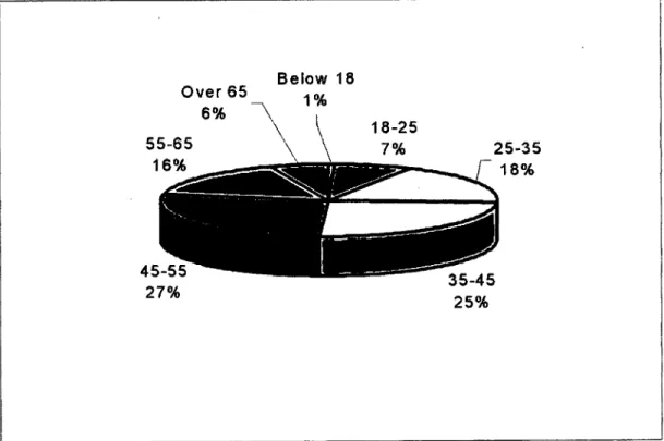
Figure 4.1: Age distribution of the sample population...53
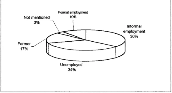
Figure 4.2: Occupation of the Sample Population in the Msimbazi valley...54
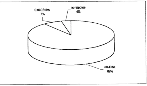
Figure 4.3: Size of land occupied in the Msimbazi Valley ...64
Figure 5.1: Changes in the built -up and Swamp Areas between 1975 and 1992...108
LIST OF TABLES Table 2.1: Causes of wetland loss ... ... 34
Table 3.1: Study sizes and sites in the Msimbazi Valley...48
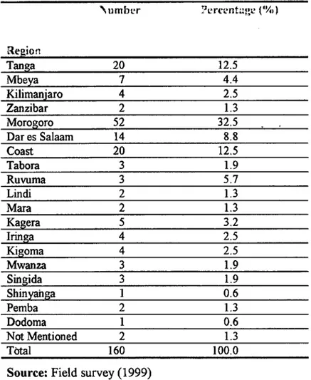
Table 4.1: Place of origin of the respondents in the Msimbazi Valley... 56
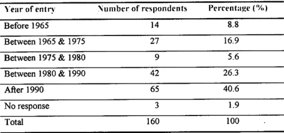
Table 4.2: Year of entry into the Msimbazi Valley... 57
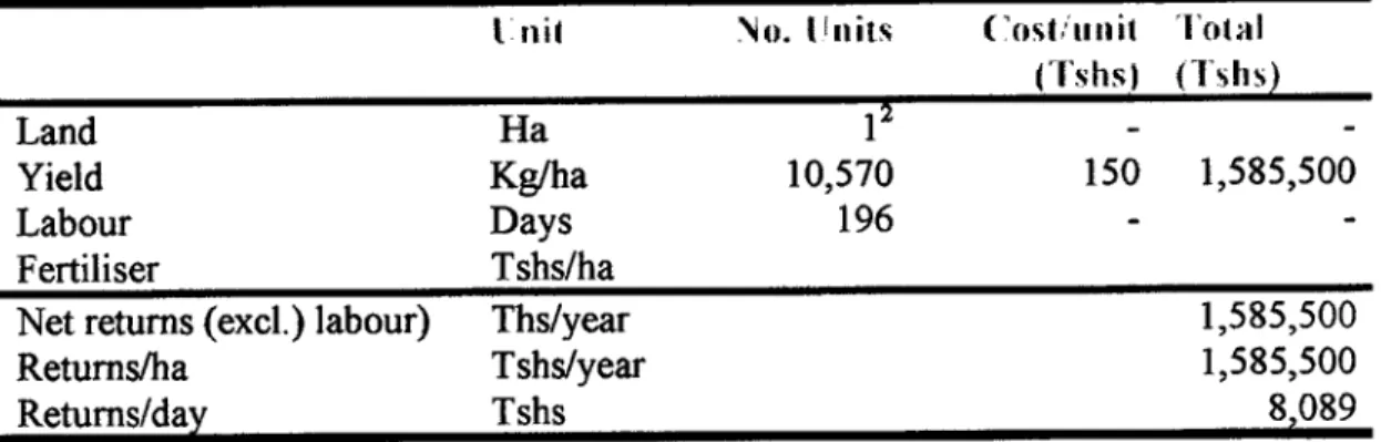
Table 4.3: Returns to amaranth farming ... ... ... 84
Table 4.4: Economic value of sand extraction at SUK1TA site ...87
Table 5.1: Major activities affecting the Msimbazi valley...90
Table 5.2:How the activities affect the valley...91
Table 5.3: Changes in Area Coverage in the Msunbazi Valley...101
Table 5.4: Changes resulting from human activities in the Valley...111
Table 6.1: People's awareness of the benefits / values of the Msimbazi wetland ...116
LIST OF PLATES Plate 4.1: One of the modem houses in the Msimbazi valley. ... 55
Plate 4.2: Some temporary settlements are seen in the background (centre) built out of temporary material (small pieces of corrugated iron sheets). ... 67
Plate 4.3: Some of the permanent, well designed and painted houses in the Valley...68
Plate 4.4: A burning pile of garbage situated near settlements in the Msimbazi valley...68
Plate 4.5: Garbage, dumped along in the Msimbazi River...69
Plate 4.6: A common pit latrine (to the right) in the Msiinbazi valley. There is a bucket hidden in the grass directly under the tube for receiving wastewater...69
Plate 4.7: A wastewater channel in the valley, Wastewater from the pit latrine (to the right) has been channelled into this local drainage system ... ... ... 70
Plate 4.8: Horticulture (fore left) maize (in the middle) and coconut trees (in the background) can be viewed. ... 71
Plate 4.9: A Ditch carrying wastewater from industries and settlements, runs through the Msimbazi Valley with its source at Tanzania Breweries Ltd...73
Plate 4.10: Sand extracted from the Msirnbazi River bed is piled on the riverbanks to drain. ... 75
Plate 4.11: Sand is piled on the roadside ready to be carried off by trucks...75
Plate 4.12: One of the garages, whith a permanent structure situated in the Msimbazi valley...78
Plate 4.13: Oils and grease (foreground left-hand corner) flowing from a nearby garage and seeps intothe valley ... 78
Plate 4.14: Patches of sugarcane and banana crops in the Msimbazi Valley. ... 83
LIST OF MAPS Map 3.1: Location of the Study Area -Msimbazi Valley...43
Map 4.1: Dares Salaarn City Expansion 1947-1996...59
Map 5.1: Msimbazi Valley study area (built up area for years 1975, 1982,and 1992)...102
Map 5.2: Msimbazi Valley study area (swamp area for years 1975,1982,and 1992)... 103
Map 5.3: Msimbazi Valley study area (1975)...105
Map 5.4: Msimbazi Valley study area (1982)...106
Map 5.5: Msunbazi Valley study area (1992)...109
CHAPTER 1
INTRODUCTION
1.1 Background Information
Wetlands are a major landscape, although they occupy only about 6 percent of the earth's surface (Turner, 1990; Turner et al., 1995; Williams, 1990). But unlike other major landscapes, such as and lands, mountains, tundra, and polar lands, which have attracted the attention of many scholars, wetlands have received attention from a range of scholars, who seek to understand their varieties and complexities only since the late 1960s. The recent interest has been prompted by the desire to understand more about their functions, characteristics and values and also how they have been perceived in the past (Williams, 1990; 1991). Before the 1960's, wetlands were largely neglected and unappreciated, and were probably the most poorly understood of landscapes and ecosystems, being neither sound land nor good water (Williams 1990). Wetlands have, often, been considered wastelands and, therefore, worthless. Thus, their transformation, through draining, dredging and in filling, seemed a fitting fate for them (Williams, 1990; 1991).
As natural ecosystems, wetlands are an essential part of the ecology, and like any other resource, they posses social and economic benefits in human life, whether directly or indirectly. These benefits include, irrigation agriculture, fishing, water supply, papyrus, sediment/toxicant retention, flood control, groundwater recharge and discharge, to mention a few. There is currently a growing appreciation of the
natural functions of wetlands, and the values that humans attach to them. Wetlands are one of the most fruitfiil areas of archaeological research, and they are the ideal setting in which to study the interactions between physical processes and human actions that encapsulate and exemplify many of the themes of mans impact on his environment (Williams, 1990; 1991). But even these new found beneficial functions of wetlands seem to be in danger of being lost with draining and in filling.
Wetlands are disappearing at an ever-increasing rate as the demand for food and modern draining techniques make them even more attractive as potential agricultural land. In addition, their flatness and perceived worthlessness make them the obvious location for large industrial plants, harbours, urban encroachment and waste (Williams, 1991). According to Howard (1992), the major threats to wetlands in Africa include competition for resources, especially water, conversion of wetlands for agricultural and urban purposes and sectoral responsibility for management.
Urban wetlands in many countries, in general, and Tanzania in particular, are being affected at an alarming rate. Urban wetlands are places within the city limits where water and soils mingle (http://www.cei.org/ebb/wetland.htm) . These are being rapidly transformed and degraded as a result of a combination of natural causes and human activity. Natural causes are subsidence, wave erosion, saltwater intrusion, sea level rise, and tropical storms and hurricanes to mention a few (www.lacoast.gov/Overview/causes.htm). Human activities have, however, taken the lead in destroying urban wetlands, through reclamation for agricultural, industrial, residential and recreational use and also through pollution
1.2 Statement of the Problem
Most urban wetlands (if not all) in Dar es Salaam are experiencing tremendous transformation whereby most of them have been converted to squatter settlements and industrial sites as is the case of the Msimbazi valley. Dar es Salaam, being both an important port in East Africa and the major industrial and commercial city in Tanzania, attracts a lot of people from all over Tanzania and beyond, who flock into the city every day. Migrants from rural areas hope to improve their poor living conditions through employment, petty trade, and urban agriculture. To the business community, Dar es Salaam provides great opportunities for investment. As a result of this, the city is facing very rapid population growth.
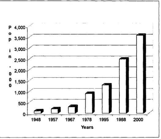
Dar es Salaam city is estimated to have between 2.5 - 3.0 million people, and a population growth rate which ranges between 7-10% per annum (SDP, 1997). In
1997 it was estimated to have 2,840,000 people with a population growth rate of 8.5%. By the year 2000, it is expected to have some 3.6 million people (Figure 1.1), while by the year 2010 and 2020, the city will be accommodating about 5 million and 8.1 million people, respectively (SDP, 1997).
As a result of rapid population growth, the demand for land in Dar es Salaam for construction, farming, waste dumping, recreation has been very high. Due to inadequate or improper planning and inadequacies in land allocation, the immigrants have been forced to encroach into and make use of wetlands for settlement, business establishments, industrial sites, agriculture and recreation. Such encroachment has, consequently, led to urban wetland degradation and even their complete transformation into other land uses. The Victoria, Msasani, and Mikocheni areas, as
well as Lake Magomeni and Lake Tandale are good examples of what used to be urban wetlands in Dar es Salaam which have now been greatly transformed into settlements, industrial areas and other social economic services.
Figure 1.1 Population of Dar es Salaam
P 4,000 0 p 3,500 3,000 " n / 2,500 0 2, 000 :::
.11
1,000 50: 1948 1957 1967 1978 1995 1988 2000 YearsSource: Sustainable Dar es Salaam Project (1997)
The Msimbazi wetland valley in Dar es Salaam is now experiencing the same nature of transformation, a significant part of its area having been turned into settlements, agricultural area and industrial sites. There is clear evidence of the valley being mismanaged, misused, and degraded. Being one of Dar es Salaam's extensive and important wetlands, the valley requires measures that will preserve it for current and future social, economic and ecological needs. If no stern measures are taken to reverse the trend, the wetland may disappear completely, like what has happened to
several other wetlands in Dar es Salaam. This study therefore, seeks to establish the extent to which urban wetlands, are being transformed and br degraded with a view of suggesting some practical measures to reduce the human impacts and conserve the wetlands. The focus of the study will be the Msimbazi valley.
1.3 Objectives of the Study
This study seeks to examine the impact of human activities on Dar es Salaam urban wetlands with a focus on the Msimbazi Valley as a case study. The study also will examine the implications of these impacts to the urban environment with the view of suggesting better ways of utilisation and conservation for the urban wetlands of Dar es Salaam. Specifically the study seeks to:
Investigate the major human activities taking place in the Msimbazi valley,
Examine the nature of changes in the status of the Msimbazi valley over time (from 1975 to 1999) as a result of human activities,
Investigate the social, economic and ecological effects of utilisation of Msimbazi valley which have and br are likely to occur,
Investigate the perception and level of awareness of the local population in Msimbazi valley on the values of wetlands, and
Examine the role of government policies in the management of urban wetlands.
1.4 Research questions:
What changes have taken place in the Msimbazi since 1975 to date as a result of human activities?
What socio-economic and ecological effects have and or are likely to occur as a result of human activities?
To what extent is the population in the Msimbazi valley aware of the values of this wetland and the effects on it caused by their activities?
What has been the role of the government in the management of urban wetlands?
1.5 Hypotheses
Urban expansion and in-filling have reduced the area coverage of Msimbazi wetland overtime.
People around Msimbazi valley are not aware of the values of the wetland.
1.6 Significance of the Study
Many studies on wetlands in Tanzania have tended to focus on major wetlands, which have agricultural, transport, fishery or any great economic potential, whether at national or international level. This in turn has led to neglect and negative perceptions by both the government and individuals towards the smaller and more localised wetlands, urban wetlands in particular. Moreover, human impacts on Tanzanian urban wetlands have not been well documented. This study departs from the current practice by looking at small urban wetlands with the hope that it will
stimulate awareness of urban planners, Ministry of Lands, academicians, researchers and the general public on the importance of small urban wetlands. This study is also significant in that it will enable urban planners to better review their plans and try to come up with strategies for serving the people and at the same time protecting the wetlands. It is also hoped that the study will enable the Ministry of Lands to look into the land laws, especially on acquisition of land, to ensure that wetlands and other fragile lands are not allocated for any human activities unless there is substantial evidence, through Environmental Impact Assessment (BIA), that the effects can be mitigated.
Moreover, the study will generate information and add knowledge on the importance of local and minor urban wetlands as being essential parts of the ecological system worth studying. It is also hoped that the study will assist the general public in their decision making on the appropriate areas to settle and the consequences of their negligence both to them and the wetland. In a nutshell, this study will help bridge the gap of knowledge concerning the Dar es Salaam urban wetlands.
1.7 Limitations of the study
Due to time and financial constraints, only a small portion of the Msimbazi wetland has been studied. Moreover, lack of population data for and along the Msimbazi wetland made it a difficult task to estimate a representative sample for the study. Because the respondents inhabit the area illegally, questions relating to their settlement within and along the area have posed problems due to fear of removal. Also, there is little information on urban wetlands, in general, and for Tanzania, in particular. It is for this reason that most of the literature available is either general or
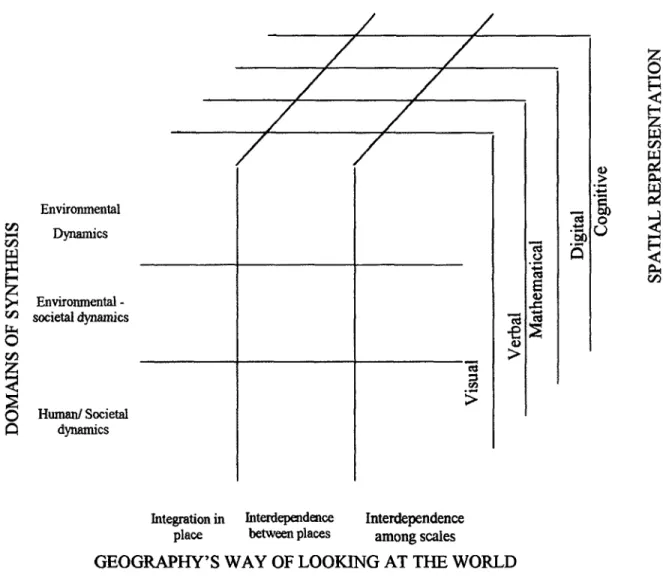
1.8.1 Theoretical Framework
This study is guided by geography's perspectives as applied in research and practice (Rediscovering Geography Committee et al. 1997). There are mainly 3 sets of perspectives (Figure 1.2), these being:
Geography's way of looking at the world: through the lenses of place, space, and
scale
Geography's domains of synthesis: environmental - societal dynamics relating
human action to the physical environment, environmental dynamics linking physical system, and human - societal dynamics linking economic, social and political systems, and
Spatial representation: using visual, verbal, mathematical, digital and cognitive
Environmental rA Damics Environmental - societal dynamics C
o
Humanl Societal dynamics a)I
-1Figure 1.2 Geography's Perspectives
Integration in Interdependence Interdependence place between places among scales
GEOGRAPHY'S WAY OF LOOKING AT THE WORLD
Source: Rediscovering Geography Committee, 1997: 29
1.8.2 Geography's way of looking at the world
A central tenant of geography is that "location matters" for understanding a variety of processes and phenomena (Rediscovering geography committee et a!, 1997). In understanding how a certain place, be it region or locality, gets its distinctive characteristics, it is first necessary to understand the different processes and
phenomena (social, economic, political and environmental) that interact in that locality or region, that is, integration in place. But no place can be totally independent in character. It has to interact with other places through flows of people, goods, materials and ideas, hence Interdependencies between places. For instance, the study area interacts with almost every region in Tanzania due to flows of people into the area, and with them, may come different ideas, social attitudes, culture, methods of cultivation and even introduction of new species. Moreover, agricultural activities practised in the Msimbazi valley affect almost the whole of Dar es Salaam city in terms of providing market for the products. This, on the other hand, gives way to Interdependencies among scales. The scale of observation is important in understanding geographic processes and phenomena at a place. For example, something done at a regional scale e.g. industrial activities, could have an impact at a global scale. To be more precise, within the study area, economic strategies imposed on Tanzania by foreign forces, such as the Structural Adjustment Program (SAP), have, to a great extent, contributed to the rural-urban migration due to changes in the agriculture sector. This, in turn, has led to overcrowding in the city and, subsequently, to wetland encroachment for settlement, industrial sites, agriculture and the like.
1.8.3 Domains of synthesis
Geography's fundamental concern for how humans use and modify the biological and physical environment (the biophysical environment) that sustains life or
environmental- societal dynamics, is the most radical departure from conventional
disciplinary specialisations. Two other important domains of synthesis within
geography are: work examining interrelationships among different biophysical processes, or environmental dynamics, and work synthesising economic, political, social, and cultural mechanisms or human societal dynamics. These domains Cut across and draw from the concerns about place embedded in geography's way of looking at the world.
Environmental dynamics examine the interrelationships among different biophysical processes. This domain is much into physical geography, and it investigates spatial patterns and dynamics of individual plant and animal taxa and the communities and ecosystems in which they occur in relation to both natural and anthropogenic processes. This is basically the field of Biogeography. The domain also attempts to describe and explain the spatial and temporal variability of the heat and moisture states of the Earth's surface, especially its land surface (Climatology). Lastly, it analyses and predicts the earth surface processes and forms (Geomorphology)
because these are constantly altered by a combination of human and natural factors.
The domain of Human societal dynamics focuses on the geographic study of interrelated economic, social, political, and cultural processes. A synthetic understanding of such processes has been sought through the attention to two questions (1) the way in which those processes affect the evolution of particular places and (2) the influence of spatial arrangements and our understanding of those processes.
The environmental —societal dynamics domain focuses on human use of and impacts on the environment, impacts on humankind of environmental change, and human perceptions of and responses to environmental change. Human actions, unavoidably,
modify or transform nature; in fact, they are often intended specifically to do so. The impacts of human action have been so extensive and profound that it is now difficult to speak of a natural environment. At the same time changes in the biophysical environment whether endogenous or human induced has had a lot of consequences for humankind. Such consequences include floods, droughts and disease. But impacts don't necessarily have to be negative. There are plenty of positive impacts that may arrive due to that change. For instance, the biophysical environment provides human kind with food and a means to generate income.
In addition to the above, Human - environment relations are greatly influenced, not just by particular activities or technologies, but also by the very ideas and attitudes that different societies hold about the environment. Geographers have recognised that the impacts of environmental change on human populations can be strongly mitigated or even prevented by human action. Accurate perception of change and its consequences is a key component in successful mitigation strategies.
1.8.4 Spatial representation
Geography is rich in types of spatial representation when studying space and place at a variety of scales (Rediscovering Geography Committee 1997). Tangible representation of geographic space may be visual, verbal, mathematical, digital, cognitive, or some combination of these (Figure 1.2).
Visual representation is done through conventional maps, which occupy a midpoint along a continuum of visual representation forms, diagrams and images. Verbal
constructed description in words. Mathematical representation includes models of space, which emphasise location, regions, and distributions; models of functional association; and models of process which emphasise spatial interaction and change in place. Cognitive representation is the way individuals mentally represent information about their environment. It ranges from attempts to derive "mental maps" of residential desirability to assessing ways in which knowledge of spatial position is mentally organised, the mechanisms through which this knowledge can be used to support behaviour in space. Finally there is Digital representation which is currently the most influential focus of representational research because of the widespread use of geographic information systems (GIS) and computer mapping.
1.8.5 Context of the study
Environmental-societal dynamics:
The study area has undergone extensive transformation. Human activities, such as, establishment of settlements, industries and other constructions within and along the wetland area, sand extraction, and agricultural practice have resulted to modifications in the river flow, extensive and intensive erosion, flooding and pollution in the study area (human use of and impact on the environment). Furthermore, there could be both animal and aquatic plant species that have either disappeared or have been introduced as a result of huMan intervention in the area. Moreover, it could be that the study area had a particular species ten or twenty years back, which no longer exists because it could not tolerate the chemical and heavy metal pollution levels from the industries at that time.
Likewise, the Msimbazi valley, being a wetland, could have an impact on the human life around the area (environmental impacts on humankind). For instance, due to its wet nature, it is a potential breeding ground for mosquitoes. Moreover, the area is susceptible to flooding, hence, becoming a hazard prone area and a danger to people's lives, property and health. But on the other hand, the area provides people with income and survival through practising agriculture both for business and subsistence, it could be used for rearing of cattle and other animals, and though not proper, people make a living out of the wetland through sand extraction.
People in the valley perceive the Msimbazi valley as an area ideal for irrigated agriculture, or as a source of sand for building. Others see the valley as a wasteland that can be drained and reclaimed, to put up buildings for settlement, for businesses or even a wasteland that is responsible for a range of waterborne diseases (human
perceptions of and responses to environmental change). Each individual or group of individuals have a different perception to the wetland and respond differently to its existence. Some see it as a threat and others as an opportunity.
Human societal dynamics:
There are social, economic, political and cultural issues in the Msimbazi valley that have contributed to what the area is today. For instance, policy implementation failure, poverty in terms of the country's economy and individual poverty, inequality, the urban bias in the development process and poor land tenure systems have, to a great deal, shaped the Msimbazi valley to what it is now.
15
Spatial representation:
This study has been adopted in form of maps, diagrams and photos. Verbal presentation occurred during the interview/field study phase, in which different residents and users of Msimbazi valley narrated and described events, changes and activities that occurred in the past and present in the valley.
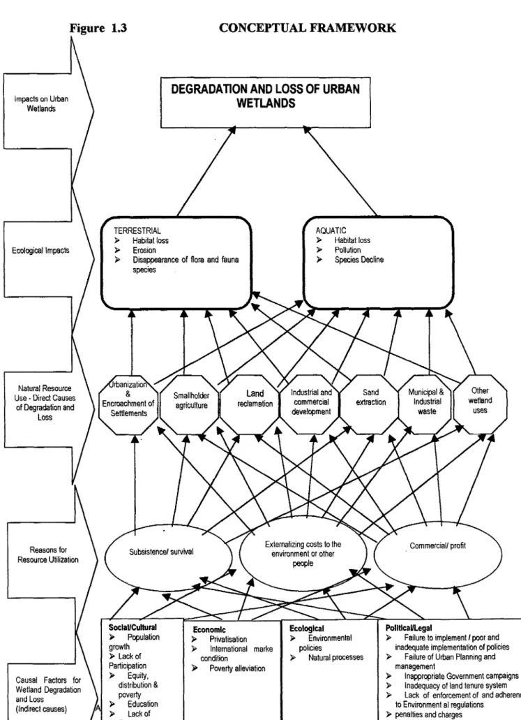
1.8.6 Conceptual framework
Figure 1.3 provides the analytical framework, which illustrates interrelationships that combine to result into the degradation and loss of urban wetlands. It is postulated that wetland degradation and loss is a result of direct and indirect driving forces working together in complex combinations.
The hypothesised direct causes or driving forces of wetland degradation and loss in this case study are identified as those associated with the utilisation of natural resources at the local level. These include settlements, smaliholder agriculture, land reclamation, industrial and commercial development, sand extraction, Municipal and industrial waste dumping and other wetland uses. The outcome of these activities may result into ecological impacts on terrestrial and aquatic environments.
The indirect causes or causal factors for wetland degradation and loss include social/cultural, economic, ecological and political/legal factors (Figure 1.3). These factors determine the nature of resource use, which could be for subsistence/survival, commercial/profit or could simply lead to externalisation of costs to the environment or other people.
Figure 1.3 CONCEPTUAL FRAMEWORK
\
DEGRADA11ONAND LOSSOF URBANImpacts on Urban WETLANDS
Wetlands
TERRESTRIAL AQUATIC
)
Habitat loss>
Habitat lossEcological Impacts
)
Erosion)
Pollution>
Disappearance of flora and fauna)
Species Declinespecies
_
U
Natural Resource rbanization
Smallholder Land Industrial and Sand Municipal
&
Other Use-
Dired Causesof Degradation and Encroachf agriculture reclamation commercial extraction Industrial wetland
Loss Settlemen) development waste uses
Reasons Subsistence/ Externalizing costs to the environment or other Corn mercial/ profit
Resource Utilization people
Causal Factors for Wetland Degradation and Loss
(Indirect causes)
Soclal!Cultural Economic Ecological PoilticaViegal
)
Population>
Privatisation>
Environmental>
Failure to implement! poor and growth>
International marke policies inadequate implementation of policiesLack of condition
>
Natural processes>
Failure of Urban Planning and Participation>
Poverty alleviation management)
Equity,>
Inappropriate Government campaignsdistribution
&
)
Inadequacy of land tenure systempoverty
>
Lack of enforcement of and adherenceEducation to Environmental regulations
17
The failure of several government policies to address critical national issues may have generated conditions unfavourable for urban wetlands. For example, the failure of government policy in agriculture to improve agricultural sector and to create conditions that would attract many people to farming has generated condition of rural —urban migration. Many people migrate from rural to urban areas in search of better oppothmities and living conditions. Most of the development activities have concentrated in urban areas -the so-called urban bias. This means that there is no equity in economic resource distribution between rural and urban areas. Urban areas have continued to pull people from rural areas, not only because of better opportunities that have concentrated in these areas, but also because agricultural sector has not been fully developed to attract and retain people.
International market conditions could also be a reason for failure in the agricultural sector. The international market dictates the price for agricultural produce and, in most case, does not provide the farmers with appropriate returns for their produce. Hence the people are disappointed by the fact that agriculture can not lead to a better life and opt for urban life as a means of survival.
As population increases in urban areas, rapid urbanisation follows. Since services in urban areas have also not been fully developed (site services schemes and social services are equally underdeveloped in urban areas), many people resort to settling in marginal areas or unplanned areas (squatting), including wetlands (Figure 1.3). Migrants in these areas are also engaged in urban farming and small scale manufacturing activities as a means of meeting their survival needs in the absence of formal employment. Urbanisation, smallholder urban agriculture, settling in
unplanned areas, as well as other activities, such as, sand extraction, land reclamation, and municipal and industrial waste dumping contribute to the degradation and loss of urban wetlands. The degradation and loss is experienced through habitat loss, erosion, disappearance of flora and fauna species, and pollution (Figure 1.3).
Government policies have, often, addressed economic growth without paying adequate attention to poverty and equity issues. The issue of equity has not been properly addressed. The gap in income between low and high-income earners has been widening. According to the National Poverty Eradication Strategy, (1998), more than 50% of Tanzanians have incomes below the poverty line (the poverty line is 73,877 per annum). Likewise Bagachwa et al. (1995) points out that the lowest 20% of the Tanzanian population has only 2% of the total income while the highest 20% has 60% of total income.
Various other activities such as smallholder agriculture, land reclamation, sand extraction and municipal and industrial waste dumping are also being practised in the areas due to different reasons, including subsistence/ survival or commercial profits. All these activities have led to the degradation and br disappearance of urban wetlands.
These areas are not only being utilised but also suffer from externalised costs resulting from the utilisation processes. For instance, unguided industrial development, land reclamation, unplanned settlement, sand extraction and waste dumping degrade urban wetlands in that they cause pollution, erosion, disappearance of flora and fauna species and loss of habitat. The environment and people who
19
regard the wetland resource as an important part of their livelihood incur all of these losses. For instance, pollutants from industries are released in the water on which people depend. Due to high level of pollution, species are either lost or decline in numbers. On the other hand, people who use the water for drinking and other domestic uses, suffer from various diseases and illnesses and incur significant expenses in medical treatment as result of the polluted waler. The owners of these industries have externalised the environmental costs to the environment and the people, instead of incurring them, through implementation of mitigation measures. Inadequate enforcement and implementation of the polluter pays' principle, as described in section 76 under economic instruments of the National Environment Policy (Vice President's Office, 1997), partly accounts for this problem. The policy states that... "The polluter-pays principle shall be adopted and implemented deterrently. In principle it shall be the responsibility of those who pollute to repair and bear the costs of pollution caused and rehabilitation, where appropriate" (VPO, 1997:31). But this has not been the case.
Urban planning in Tanzania has been facing numerous problems, including implementation failures (Figure 1.3). For example, urban planning presupposes that settlement in urban areas will be in planned and surveyed areas only. In practice this has not been the case. Urban authorities have ignored the enforcement of regulations to the extent that most of the inhabitants in these areas regard their settlement as normal and legally accepted. After all, they are getting basic services such as water and electricity like any other individual in planned areas. Lack of enforcement and adherence to laid down regulation regarding human settlement, industrial location, waste deposal sites and farming in urban areas has led to degradation of the urban
wetlands.
Lack of participation in conservation, planning and implementation of plans has also had an adverse effect on urban wetlands. Most directives and plans have had the top-down approach where people are simply given directives to follow but not really involved in decision making or in airing their opinions, in matters concerning urban development. Inadequate awareness and education on environmental issues also contribute to the degradation and loss of urban wetlands. Most of the people in these areas tend to utilise the urban wetlands for settlement or industrial location in order to meet either their subsistence/ survival needs or to seek more profits. In most cases, these people are not aware of the implications of their decisions. This in turn leads to habitat loss, erosion, pollution, species decline and disappearance and, hence, the degradation and loss of urban wetlands.
In this study, the degradation of urban wetlands is traced from the social/cultural, economic, ecological, and legal factors through the broad policy issues to the implementation of these policies and their effects. It is perceived that most of the impacts are a result of human activities either in response to certain policy initiatives or as an attempt to address specific human needs.
21
CHAPTER 2
LITERATURE REVIEW
2.1 Defining wetlands
There have been various perceptions on the term 'wetlands'. This is because it is a relatively new term in describing the landscape that many people knew before under different names. In England for example, wetlands have been large enough to acquire regional names such as Fens of eastern England, broads of Norfolk (Williams, 1990), only to mention a few. Other names are such as mires, bogs, sloughs, swamps and marshes (Williams, 1990). Yet there are terminologies used in some parts of the world, which are completely different from these or may be the same, but imply something different. However, these names say little about their composition or origin (Williams, 1990).
Because wetlands occur in many different locations and climatic zones, and have many different soil and sediment characteristics, they have become an integral part of the landscape since earliest times, and sometimes of the economy as well (Williams,
1990). It is for this reason, and perhaps others that the term 'wetlands' has been exposed to various definitions and perceptions.
Maltby (1986: 200) defines a wetland as "a collective term for ecosystems whose formation has been dominated by water and whose processes and characteristics are largely controlled by water". Similarly, AlIaby (1994 in Sabai 1999:6) refers to wetland as "a general term applied to open water habitats and seasonally or permanently waterlogged land areas, including lakes, rivers and estuarine and fresh
water marshes". On the other hand, Coeardian et al. (1979 in Sabai 1999:6) defines wetlands as "lands of transition between terrestrial and aquatic systems where the water table is usually at or near the surface of the land or the land is covered by shallow water".
The Ramsar convention on wetlands in article 1, defines wetland as an area of marsh, fen, peat land or water, whether natural or artificial, permanent or temporary with water that is static or flowing, brackish or salt, including area of marine water the depth of which does not exceed six meters (Howard, 1993; in Roggeri, 1995:11). Roggeri (1995:11) includes other aspects of wetlands as he states that; 1'wetlands include both land ecosystems whose ecology is strongly influenced by water, and aquatic ecosystems with special characteristics due to their shallowness and the proximity to land."
Whatever definition is given to wetlands, the realisation has grown that the distinguishing feature about all these types of wetland is the interplay between land and water and the sharing of the characteristics of both. Hydrology is key to their formation. But in addition, wetlands have a distinctive ecological composition and character which arises from the fact that they are situated at the junction between dry land territorial ecosystems and permanently wet, aquatic ecosystems. They differ from both but partake the characteristics of either (Williams 1991).
With the exception of the Ramsar definition, the remaining definitions that have been cited above, tend to either stress on the importance of water in wetlands and pay little attention to other aspects of wetlands (Maltby 1986; Allaby 1994), or are highly generalised, assuming that all wetlands possess the same characteristics. The Ramsar
23
definition, on the other hand, has been able to describe and to capture the diversity and variety of wetlands. It tends to include characteristics that distinguish one wetland type from the other, indicating the differences in terms of character and origin. It is for these reasons that this definition will be used for the purpose of this study.
2.2 Perceptions on wetlands
There are various perceptions toward wetland areas. Such perceptions, together with definitions, shape the way in which the management of wetlands takes place. Most people consider wetlands as synonymous with wastelands and thus unimportant ecosystems that are breeding grounds for mosquitoes, snails, frogs and vectors that transmit bilharzia (Kamau, 1993).
According to the IUCN (1990), the traditional image of wetlands was (and still is in some parts of the world) that of inaccessible water logged marginal lands harbouring disease - carrying mosquitoes, where the first available funds should be allocated to drainage and conversion. Furthermore, wetlands have been regarded as unproductive and unhealthy lands, full of disease-carrying insects and crocodiles (Turner et al., 1995). Thus great efforts have been made to convert them for intensive agricultural or fisheries production or fill them in to create land for industrial or urban development.
In Tanzania the Ministry of Lands and Human Settlement Development and the Ministry of Regional Administration and Local Government, through sustainable cities program, perceive wetlands as 'hazard' lands (SDP, 1997). According to the
Sustainable Dar es Salaam Project (SDP), the hazardous elements include soil erosion, piping, excessive drainage, landslides, and other features which limit land development for building or agriculture without appropriate engineering (SDP, 1997). This perception focuses on lands such as, steep slopes, floodplains (valleys) and the coastal belt (characterised by swamps, marshes, and salt flats). These areas have been categorised on the basis of their cause and effect relationships, as well as the environment- development interactions (SDP, undated; Rugumamu et al., 1997). These areas have pronounced down stream and upstream environmental impacts related to and reflected by the intensity of development initiatives (SDP, 1997). The above perception also focuses on how human activities can be carried out in the wetland, but pays little attention to ecological and biological values of the wetland, including being utilised as buffer against floods and a source of water and other natural resources. In addition, this perception implies that once you have appropriate technology, you can convert wetlands to other uses.
Due to the fact that programs, such as Sustainable Dar es Salaam Project (SDP) under the City Commission, consider urban wetlands as hazard lands or wastelands, there has been inadequate planning and management of the urban wetland areas, hence, leading to their uncontrollable use. There are no firm government structures to ensure the proper use or protection of the urban wetlands. Consequently, the urban wetlands of Dar es Salaam, which have, for some time, been perceived as 'no mans land', have been experiencing tremendous transformation. For instance, some parts of Victoria, Mikocheni, and Msasani areas in Kinondoni District, which in earlier years were extensive wetland areas with perhaps great biodiversity, are no longer wetlands. These areas have been and are still being transformed into settlements and business
25
centres at a rapid rate. Other cases, which have also undergone tremendous transformation, include Lake Tandale, Lake Makurumla, Lake Magomeni and Lake Mwananyamala. These have either completely disappeared or have been greatly reduced in size and potentiality.
The Msimbazi valley is one of Dar es Salaam's extensive and important wetland areas, which require measures to preserve it for current and fliture social, economic and ecological needs. In this recent decade the Msimbazi wetland has been facing rapid transformation. It is being encroached upon by squatter settlements and industries. Also activities such as sand extraction and smallholder agricultural are taking place in the area (Kondoro et al., 1998). There are proposals to convert part of the Jangwani valley within the Msimbazi area into ultra-modern stadium complex complete with shopping and business facilities (SDP 1998). Part of this area is now being used as a collection point for waste before it is further transported to dumping
sites. Various religious groups use the same area for meetings. There is, therefore, need to see to what extent all these activities are affecting the wetland and at what rate.
2.3 Values and functions of wetlands
Wetlands are often the only places where certain natural functions take place; destroy the wetland and these precious services will be lost (Skinner and Zalewski, 1995). How a wetland works depends on its particular biological and physical characteristics. Few wetlands will perform certain functions with equal efficiency. However, a given wetland will usually have a range of different functions. These include social-economic, hydrology, ecology and biodiversity functions.
2.3.1 Social economic values and functions of wetlands:
The value of a wetland can be partly assessed in terms of the direct use of its resources for the satisfaction of human needs. The use of these resources may be extensive or intensive.
Wetlands are multifunctional and can be considered as capital assets, which require appropriate (sustainable) management if they are to continue to produce the flow of wetland derived functions, services and goods (Turner et al., 1995). This flow is generated by species and processes, in what is referred to as life-support systems, which generate a range of ecosystem- produced functions and service (Odum, 1989; Turner et al., 1995).
Plants, animals, fish, soil and water found in wetlands yields benefits, which are of direct use value to humans. Many tropical wetlands are being directly exploited to support human livelihoods. Fish being one of the resources found in some wetlands represents around twenty percent of the animal protein intake of Africans (Turner, 1990). In Tanzania, wetlands are used for fisheries, agriculture and irrigation, livestock grazing, wildlife conservation and tourism, hydropower and water supply, extraction of traditional products and scientific research (Kamukala, 1991; Daffa and Muheto, 1994).
2.3.2 Hydrology, Ecology and Biodiversity functions:
One reason why wetlands are so important is the unique wildlife and vegetation they support (wwv. .lacoast.o aIi.htm). T- are among the most productive natural ecosystems on earth, they produce great quantities of plants, some
27
of which could not live anywhere else.
The interaction between wetland hydrology and topology, saturated soil and emergent vegetation, generally, determines the characteristics and the significance of the processes that occur in a wetland (Turner, 1990). These processes are subsequently responsible for hydrological, ecological and biodiversity functional services. Storm buffering and pollution retention are two examples of these services (Turner, 1990).
According to Turner et al. (1995), IUCN (1990) Roggeri (1995), as well as Skinner and Zalewski (1995), wetlands provide a wide array of environmental goods and services of high value to society as follows:
• They change sharp run off peaks, from heavy rains and storms, to slower discharges over longer periods of time, and thus prevent floods.
• They recharge ground water aquifers, providing valuable drinking water during dry seasons. A wetland can play a crucial role in the both providing water and acting as an infiltration zone, or it may flow laterally underground until it rises to the surface in another wetland as groundwater discharge. Thus recharge in one wetland is linked to discharge in another. Recharge is also beneficial for flood storage because runoff is temporarily stored underground, rather than moving swiftly downstream and overflowing.
• Groundwater Discharge: This function occurs when water that has been stored underground moves upward into a wetland and becomes surface water. Some wetlands allow both wet season ground water recharge and dry- season ground
water discharge. Wetlands that receive most of their water from ground water discharge usually support more stable biological communities, because water temperatures and water levels do not fluctuate as much as in wetlands which are dependent upon surface flow.
• Wetlands act as sinks for inorganic nutrients and many are sources of organic materials to downstream or adjacent ecosystems. This firnction occurs when nutrients, most importantly nitrogen and phosphorus, accumulate in the sub-soil, or are stored in wetland vegetation. Wetlands that remove nutrients improve water quality and help prevent eutrophication. This can avoid the need to build water treatment facilities.
• A common role of wetlands during the growing seasons is to accumulate nutrients when water flows slowly. These nutrients then support production of fish and shrimp, as well as the forest, wildlife and agricultural wetland products. When water flows fast, it acts as a source.
• Sediment /Toxicant Retention: Runoff, as well as river and lake water are slowed down when they enter a wetland. This is due to the spread of floodwater over a large area, its immobilisation in low-lying basins and depressions or the moderating effects of the vegetation (e.g. swamp vegetation). In lakes, aquatic vegetation slows down the water movement both on the surface (waves) and at depth (current). All these mechanisms encourage the settling of suspended detrital material (Howard- Williams & Gaudet, 1985; Howard- Williams & Thompson, 1985; Meade, 1988; Sather & Smith, 1984). In so doing, the wetland has the capacity to improve water quality and often serve as a filter for wastes,
reducing the transport of nutrients and organic materials, sediments and toxic substances into coastal areas. For this reason they are often referred to as the
kidneys of the landscape.
• Natural Flood Control & Flow Regulation: By storing precipitation and releasing run off evenly, wetlands can diminish the destructive onslaught of flood crest downstream. Wetlands and especially floodplains function as buffer zones between up stream and downstream regions. Wetland also limits peak flood-levels and increases low-water flood-levels for at least part of the dry season. Floodwater spreads across extensive areas and is stored until the river or lake level lowers. This delays flooding in down stream areas.
• Wetland vegetation can stabilise shorelines by reducing the energy of waves, currents, or other erosive forces, while simultaneously holding the bottom sediment in place by plant roots. This can prevent the erosion of valuable agricultural and residential land and property damage. In some cases, wetlands may help to build up land.
• Nutrient JBiomass export: Nutrient export is the function which allows wetlands to supply other ecosystems with mineral elements and organic compounds. Wetlands accumulate nutrients during the plant growth season, transfer during the plant growth season, transform them and finally 'export' a part of them during the high water season (Larson et al., 1988 in Roggeri, 1995). Nutrients exported in this way enrich adjacent or downstream ecosystems and constitute an essential source of food for the organisms they host, such as, fish, plankton, and birds (Howard-Williams & Gudet, 1985 in Roggeri 1995).
• Wetlands are also involved in the global bio-geo-chemical cycles and contribute to the global stability of available nitrogen, atmospheric sulphur, carbon dioxide, and methane.
• Wetlands are important habitats for flora and fauna, and serve as nursery and feeding areas for both aquatic and terrestrial migratory species. For these reasons wetlands often have high recreational, preservational and aesthetic values.
Rodgers (1992) suggests that recognised wetland values are in both plant and animals groups, and cover all vertebrate and invertebrate taxa. Perhaps the most critical biodiversity value of wetlands is that of the integrated ftmctioning of the individual systems. These systems are crucial for mankind's activities.
Turner (1990) adds that the contributory benefits of wetlands extend beyond the boundaries of the wetland itself, and for some classes of wetland, may be globally significant. Wetlands support migratory fish and bird populations of international importance, for example, Flamingos at Lake Natron and Lake Manyara in Tanzania.
Foster (1979) argues that much more difficult to prove are the non-consumptive benefits. These include scenic, recreational, educational, aesthetic, archaeological, scientific, heritage and historical benefits, which are difficult to define, let alone quantify. Forester however compares consumptive and non-consumptive benefits using measures, such as monetary benefits, whilst ignoring that non-consumptive benefits may not have monetary values.
These non-consumptive benefits have, usually, been considered of secondary importance compared with the direct consumptive and economic products that can be
31
quantified and have dollar and pound signs put on them, thus becoming amenable to cost-benefit analysis. Perhaps this is not surprising as non-consumptive benefits are intangible and can be highly subjective and difficult to value (Niering and Palmisano, 1979; Reimold and Hardinsky, 1978).
2.4 Wetland loss
The Independent Commission on Population and Quality of Life (ICPQL) (1996) argues that the biggest threat to biodiversity (the number and variety of genes, species, and ecosystems) is the loss of natural habitats. In developing countries, these are being lost at record rates to farmland and urban expansion (agriculture, horticulture, housing, roads, and work places). This includes wetlands, which are important habitats for a range of biodiversity. As wetlands are threatened, so is biodiversity. In many parts of the developing world, wetlands are being lost at different rates and for different reasons. Thailand, for example, is estimated to have lost 87 percent of its original mangroves and 96 percent of its wetlands (ICPQL,
1996). Australia has lost 95 percent of its marshland and other wetlands (ibid. 1996). In New Zealand it is estimated that over 90% of natural wetlands have been destroyed since European settlement, and drainage continues. (Smith, 1986 in Dugan, 1990) 14% of remaining fresh water wetlands were drained in the North
.2 Island in the five-year period from 1979 to 1983 (Smith, 1986 in Dugan, 1990).
According to Dugan (1990), the United States has lost some 54% (87 million hectares) of its original wetlands while in some states the proportion lost is even higher.
population density, the proportion of wetland loss is believed to be great (Dugan, 1990). 40% of the coastal wetlands of Brittany have been lost since 1960, and drainage and similar activities seriously affect two-thirds of the remainder of wetlands (Mermet, 1983 in Baldock, 1984). In Southwest France some 80% of the marshes have been drained, while in Portugal, some 70% of the wetlands of the Western Algarve, including 601/o of the estuarine habitats, have been converted for agricultural and industrial development (Pullan, 1988 in Dugan, 1990).
Little detailed information is available on rates of wetland loss in developing countries. However, what is available gives rise to considerable concern that entire ecosystems are now under threat. In Philippines, for example, some 300,000 ha. (67%) of the country's mangrove resources were lost in the 60 years from 1920-1980 (Zamora, 1984 in IUCN 1990), with some 170,000 ha. being converted to culture ponds for shrimp and milkfish (Hamilton and Snedaker, 1984). In Southeast Asia, huge areas of swamp forest have been converted into agricultural land, especially rice fields (Whitmore, 1989 in Roggori, 1995). In Peninsular Malaysia, 90% of the fresh water swamps have been destroyed to clear land for rice cultivation (Dugan,
1990 in Roggori 1995).
During the last few decades, tropical wetlands have also been destroyed or considerably altered. Dams and embankments now prevent water from spreading into the floodplains of several rivers, like the Senegal, Volta and Nile (Roggeri, 1995). In Nigeria, the floodplain ofHadejia River has been reduced by over 300 km 2 as a result of dam construction (Adams & Hollis, 1988 in IIJCN, 1990). Similarly in Brazil, most estuarine wetlands have been degraded as a result of pollution (Diegues, 1989
33
in 1UCN, 1990). Information on wetland loss in Tanzania is scant and unreliable. There is no quantitative data on the rate of wetland loss in Tanzania.
A combination of natural causes and human activity (Table 2.1) has caused this tremendous loss. Natural causes include subsidence, wave erosion, saltwater intrusion, sea level rise, and tropical storms and hurricanes. However, it is human activity that has been most detrimental to wetlands (www.lacoast.gov/Overview/causes.htm) . Human activity has eliminated or converted millions of acres of wetlands for other uses. The nations ever increasing population and growing need for food and housing is one of the main root-cause for this loss (www.lacoast.gov/Overview/causes.htm). Tanzanian Wetlands are threatened by over exploitation, conversion, pollution and invasive species
0.
0 CO ICV *j3 LLE -.1 0.. c#- v v v v ?. v v v 0 0 ?. 000 iv v V V A. 00 v ?. A. A. A. 00 V V V V A. 00 iv v V V v 00 00 A. V V V V V V V V V V A. v v v V 0 0 V V V V v V 0 0 v v A. 0 00 v V V V V 000 000 v 00 000 A.A.A. 00v A.A.A. 0 A. 0?. 0 v 00 Table 2.1 The Causes of Wetland Loss
HUMAN ACTIONS
DIRECT
Drainage for agriculture, forestry, and mosquito control.
Dredging and stream channelization For navigation and flood protection Filling for solid waste disposal, Roads, and commercial, residential and industrial development.
Conversion for aquaculture/mariculture Construction of dykes, dams, levees, and seawalls for flood control, water
Supply, imgation and storm protection. Discharges of pesticides, herbicides, Nutrients from domestic sewage and agricultural runoff, and sediment. Mining of wetland soils for peat, coal, gravel, phosphate and other materials. Groundwater abstraction
INDIRECT
Sediment diversion by dams deep channels and other structures. Hydrological alterations by canals, Roads and other structures.
Subsidence due to extraction of ground-Water, oil, gas and other minerals.
NATURAL CAUSES
Subsidence Sea-level rise Drought
Hurricanes and other storms Erosion
Biotic effects
Key: v = Common and important cause of wetland degradation and loss; A. = Present, but not a major cause of loss; 0 = Absent or exceptional.
35
2.5 Urbanisation and Wetland loss
Urbanisation is a major force influencing loss of wetland globally. Most major metropolitan areas face the growing problems of urban sprawl, which include a loss of natural vegetation and open spaces and a general decline in the spatial extent and connectivity of wetlands, wildlife, habitat and agricultural lands (http/www.cr.usgs.gov/umamp/htmls) . Residential and commercial development is replacing undeveloped land at unprecedented rate.
Urbanisation exerts heavy social, ecological, environmental and climatic pressures on surrounding lands in comparison to its spatial extent (http/www.cr.usgs.gov/umamp/htmls) . Reflecting on experiences in the US, Baines
(1995) argues that human activities leave their mark everywhere, adding that much of the urban surface water has been squeezed out of urban areas. Rivers have been confined between engineered flood banks, streams and ditches have been piped underground, and that most of the marshy riverside land was drained and build over, long ago (Baines, 1995). Urban wetlands tend to be seen as repositories for waste disposal. All type of waste is dumped into canals, ponds, lakes and rivers, and a good deal of the essential habitat management of urban wetlands revolves around dealing with this problem (Baines, 1995).
Gilbert and Ward (1988), drawing from examples of three cities of Mexico, Venezuela and Colombia, point out that the city poor occupy the worst land in terms of acquired characteristics; the areas with the worst pollution, the areas with least services and worst transportation. More often than not, they also occupy the worst land in terms of inherent characteristics; the areas most liable to flooding, areas