HAL Id: tel-00616794
https://tel.archives-ouvertes.fr/tel-00616794
Submitted on 24 Aug 2011
HAL is a multi-disciplinary open access archive for the deposit and dissemination of sci-entific research documents, whether they are pub-lished or not. The documents may come from teaching and research institutions in France or abroad, or from public or private research centers.
L’archive ouverte pluridisciplinaire HAL, est destinée au dépôt et à la diffusion de documents scientifiques de niveau recherche, publiés ou non, émanant des établissements d’enseignement et de recherche français ou étrangers, des laboratoires publics ou privés.
approche micro-régionale du peuplement en Languedoc
oriental
Élise Fovet
To cite this version:
Élise Fovet. Dynamiques socio-environnementales durant l’Antiquité: approche micro-régionale du peuplement en Languedoc oriental. Sciences de l’Homme et Société. Université de Franche-Comté; Univerza v Ljubljani, 2010. Français. �tel-00616794�
ECOLE DOCTORALE « LANGAGES, ESPACES, TEMPS, SOCIETES »
UNIVERZA V LJUBLJANI
FAKULTETA ZA GRADBENIŠTVO IN GEODEZIJO
Thèse en vue de l’obtention du titre de docteur en
ARCHEOLOGIE
DYNAMIQUES SOCIO-ENVIRONNEMENTALES DURANT
L’ANTIQUITE
APPROCHE MICRO-REGIONALE DU PEUPLEMENT EN LANGUEDOC ORIENTAL
Vol. 1 : texte
Présentée et soutenue publiquement par
Élise FOVET
Le 17 décembre 2010
Sous la direction de François FAVORY / Krištof OŠTIR
Membres du Jury :
M. François FAVORY, Professeur des universités, Université de Franche-Comté, directeur
M. Jean-Luc FICHES, Directeur de recherche CNRS, UMR 5140 - Montpellier III, rapporteur
M. Patrice LANGLOIS, Professeur des universités, Université de Rouen
M. Krištof OŠTIR, Associate Professor, Senior Research Fellow, Université de Ljubljana, co-directeur
M. Claude RAYNAUD, Directeur de recherche CNRS, UMR 5140 - Montpellier III, rapporteur
REMERCIEMENTS
Ma reconnaissance va tout d’abord à mes directeurs de recherche. M. François Favory supervise mes travaux depuis de nombreuses années, il a su me guider avec bienveillance jusqu’à l’accomplissement de ce travail. Je tiens à saluer ici ses qualités d’écoute, tout autant que la sagacité de son encadrement scientifique. M. Kristof Oštir a suivi mes travaux de télédétection, et cette étude n’aurait pu aboutir sans ses précieux conseils. Je le remercie également de m’avoir adopté comme membre de son équipe.
Mes remerciements s’adressent ensuite aux membres du jury, M. Jean-Luc Fiches, M. Patrice Langlois, M. Claude Raynaud et M. François Pierre Tourneux, pour le temps et l’attention qu’ils ont bien voulu accorder à l’examen de cette thèse.
La recherche que j’ai entreprise repose dans une large mesure sur le traitement de données collectées par mes prédécesseurs sur le terrain étudié, cette thèse n’aurait pu voir le jour sans les travaux de M. Roland Bonnaud, M. Jean-Claude Bessac et M. Claude Raynaud. Je trouve ici l’occasion de les remercier et de saluer la qualité de leur travail.
Si la rédaction d’un mémoire est un exercice individuel, elle résulte d’un travail de recherche nourri d’échanges et de collaborations. C’est avec plaisir que je remercie toutes les personnes qui m’ont prodigué leurs concours et leurs conseils. Je souhaite, en premier lieu, exprimer toute ma reconnaissance à Laure Nuninger, pour m'avoir épaulée aussi activement dans les différentes étapes de mes recherches. Les projets collectifs auxquelles elle m’a fait participer ont considérablement enrichi mon travail, et m’ont beaucoup stimulée dans mon entreprise. Je remercie chaudement Klemen Zakšek, pour le vif intérêt qu’il a porté à notre collaboration, et sans qui je n’aurais pu aborder la modélisation des réseaux viaire de la manière dont je l’ai fait ; je rend ici hommage à son intelligence, sa créativité et sa gentillesse.
Je tiens à saluer toute l’équipe du IAPŠ (Institut pour des études anthropologiques et spatiales), qui m’a cordialement accueilli. Je souhaite remercier plus particulièrement les membres qui ont, à des degrés divers, contribué à mon travail : Tatjana Veljanovski, qui a toujours pris le temps de discuter avec moi dès que j’en avais besoin, et dont les compétences vis-à-vis des images Landsat m’ont été fort utiles ; Žiga Kokalj, Peter Pehani et Aleš
informatiques, petits et grands, qui ont jalonné mon parcours ; Melita Robič et Saša Čaval, qui m’ont très efficacement préservée des soucis administratifs. J’adresse une mention spéciale à Peter, Aleš et Klemen qui, ayant le même rythme biologique que moi, ont fait du déjeuné un moment très appréciable.
Je dois également beaucoup à Marie-Jeanne Ouriachi, qui a fortement contribué, par son soutien moral, ses nombreuses relectures et ses commentaires pertinents, à l’achèvement de cette thèse. Je tiens à la remercier chaleureusement de l’intérêt qu’elle a porté à mon travail, du temps qu’elle m’a consacré malgré un agenda déjà bien rempli… et même de la bienveillante pression qu’elle a dû exercer sur moi ces derniers mois.
Je souhaite aussi saluer les membres des groupes de travail "territoire et peuplement" et "aires d’approvisionnement" du programme ArchaeDyn. Ce projet collectif m’a permis d’enrichir mes travaux au regard de ceux des autres chercheurs qui y participent. Et j’en profite pour lancer un clin d’œil à mon ancien binôme, Nicolas Poirier.
Merci à Iouri Bermond, pour m’avoir permis de dépouiller la documentation archivée au service régional de l’archéologie du Languedoc-Roussillon.
Je remercie les membres de la MSHE Ledoux, qui m’ont toujours aimablement accueillie et efficacement assistée, chaque fois que j’ai eu à recourir à leurs services ; merci à Marion Landré pour son concours amical, et pour son sourire.
Merci à Florian Tolle et Rachel Opitz, qui ont tour à tour partagé le même local de travail que moi et qui ont, par conséquent, eu à me supporter quotidiennement ; ils ne m’en ont cependant pas tenu rigueur et m’ont même apporté de nombreuses petites aides. Qu’ils en soient ici remerciés. Bien que nous n’ayons pas voulu partager le même bureau, je voudrais saluer ici très chaleureusement mon camarade de thèse, Robin Brigand, qui fut un soutien moral de première importance.
Il me faut bien sûr remercier mes proches, famille et amis, de m’avoir souvent réconfortée.
Et puisque l’on garde toujours le meilleur pour la fin, j’adresse mes derniers remerciements à Zoran, qui a vécu cette thèse presque autant que moi, pour son indéfectible soutien et pour sa patience à mon égard.
SOMMAIRE
Remerciements ... 3 Sommaire ... 5 Avertissements... 7 Povzetek... 9 Abstract ... 19 Introduction générale... 291.
C
ONTEXTE DE LA RECHERCHE ET TRAITEMENT DE L’
INFORMATION... 33
1.1 Etat de la question ... 35
1.1.1 Etat des recherches archéologiques en Languedoc oriental ... 35
1.1.1.1 Des microrégions parcourues... 36
1.1.1.2 Les études sur le peuplement rural... 37
1.1.2 Problématique et axes développés dans ce travail... 42
1.2 Contexte géographique ... 47
1.2.1 Un espace contrasté ... 48
1.2.2 Ressources naturelles et contraintes ... 49
1.2.2.1 Qualité des sols ... 49
1.2.2.2 Ressources en eau ... 56
1.2.2.3 Ressources en matières premières... 58
Les calcaires ... 58
Le minerai de fer ... 60
L’argile ... 61
1.3 Contexte archéologique... 63
1.3.1 Historique des recherches dans les vallées de l’Aigalade et du Brié ... 63
1.3.2 Enregistrement et traitement de la documentation archéologique ... 65
1.3.2.1 Mode d’enregistrement ... 70
1.3.2.2 Catégories de site ... 72
1.3.2.3 Traitement de l’information... 74
2.
S
TRUCTURE ET DYNAMIQUE DU PEUPLEMENT... 79
2.1 Structure du peuplement ... 81
2.1.1 Le corpus ... 81
2.1.1.1 Caractéristiques générales... 81
2.1.1.2 Un corpus d’établissements particulier ? ... 88
2.1.1.3 La question des petits établissements... 91
2.1.2 Typologie des établissements ... 95
2.1.2.1 Mise en œuvre... 96
2.1.2.2 Confrontation avec des sites fouillés ... 109
2.2 Dynamique du peuplement... 131
2.2.1 Une dynamique particulière ?... 131
2.2.1 L’extraction du calcaire des Lens : quelle influence ?... 165
2.2.2 Le bassin de Combas : une population en marge ? ... 167
3.
P
EUPLEMENT ET RESSOURCES AGROPASTORALES... 173
3.1 Une approche des terroirs perdus... 175
3.1.1 Caractérisation des terroirs ... 175
3.1.1.1 Qualités des sols et archéologie ... 175
3.1.1.2 Méthode pour une détermination des terroirs ... 181
3.1.2 La télédétection satellitaire pour une caractérisation des sols... 185
Prétraitements... 193
Méthodologie ... 195
3.1.2.1 Elaboration d’un indicateur du comportement des surfaces ... 198
3.1.2.2 Paysage actuel et paysage passé... 215
3.1.2.3 Indicateur du comportement des surfaces et peuplement antique... 221
3.1.3 Modélisation des terroirs : les "contextes géographiques" ... 226
3.2 Evolution de l’occupation des sols ... 229
3.2.1 Méthode d’analyse ... 229
3.2.2 Trames de peuplement et terroirs... 238
4.
P
EUPLEMENT ET RESEAUX DE COMMUNICATION... 249
4.1 Une approche par modélisation ... 251
4.1.1 Le réseau viaire ancien : une connaissance lacunaire ... 252
4.1.2 Modélisation des cheminements optimaux ... 255
4.1.2.1 Modélisation des cheminements de moindre coût ... 258
4.1.2.2 Introduction d’un facteur perceptif : le champ visuel ... 269
4.1.2.3 Modélisation des chemins optimaux et réseau de communication antique ... 272
4.2 Trames de peuplement et réseaux viaires ... 284
4.2.1 Evolution des réseaux de communication régional... 284
4.2.2 Dynamique du peuplement local et contexte régional ... 294
Conclusion générale ... 301
Glossaire... 313
Table des figures... 317
Liste des documents placés en annexe ... 319
Avertissements
La présente version comprend de menues corrections par rapport au mémoire initialement soumis aux membres du jury. Ces corrections ont été effectuées à partir des remarques faites par les membres du jury lors de la soutenance.
Le volume 2 "cartes et annexes" contient les annexes ainsi que les illustrations (cartes, tableaux et graphiques) placées hors-texte pour faciliter la lecture comparée du texte et de ces illustrations. Afin de simplifier le système de renvoi aux illustrations contenues dans et en dehors du texte, tous les éléments placés dans le volume 2 ont reçu le qualificatif "annexes" (à la différence des "figures" placées dans le volume de texte) et sont présentés dans l’ordre de leur citation dans le volume 1.
Tous les appels bibliographiques du volume 2 renvoient à la bibliographie détaillée à la fin du volume 1.
POVZETEK
Socialno-okoljske dinamike v klasični antiki: mikro-regionalni pristop k analizi naselbinskih vzorcev, vzhodni Languedoc (jugovzhodna Francija)
V doktorskem delu smo raziskovali evolucijo preteklih naselbinskih vzorcev v notranjosti območja Languedoc (jugovzhodna Francija). Delo temelji na raziskavah, ki so jih različni raziskovalci opravili v preteklih desetletjih: od zgodnjih mikro-regionalnih študij (Beaucairois: Favory, Fiches et Girardot 1987-1988, ravan Lunel-Viel in étang de l’Or: Favory, Girardot, Raynaud et al. 1994 ; Favory, Parodi, Poupet et al. 1994), do najnoveših doktorskih regionalnih železnodobnih (Nuninger 2002) in antičnih študij (Ouriachi 2009), preko raziskovalnega programa Archaeomedes, ki je močno vplival na raziskave poselitvenih vzorcev in razvoj prostorske arheologije v Franciji nasploh (Durand-Dastes, Favory, Fiches et al. 1998 ; Van der Leeuw, Favory et Fiches 2003 ; Favory, Girardot, Nuninger et al. 1999). Prispevek pričujočega doktorskega dela je predvsem v nadaljnjem razvoju analiz vloge geografskega okolja - fizičnega in družbenega - na spreminjanje rabe tal v rimskem obdobju. Pri tem smo razvili dve veji raziskav: karakterizacija agrarnih in pašniških virov - predvsem z uporabo satelitskega daljinskega zaznavanja - in modeliranje komunikacijskih mrež - na temelju modeliranja optimalnih poti. Za izbrano študijsko območje razpolagamo z odličnimi arheološkimi podatki, zato je to metodološko doktorsko delo sestavni del raziskovalnega programa ArchaeDyn (Collectif ArchaeDyn 2008).
Na tem mestu predstavljena raziskava je osredotočena na analizo vpliva “okoljskih” dejavnikov na naselbinske vzorce, ki jih razumemo kot sisteme dolgega trajanja, t.i. longue durée sisteme. Za preučevanje rimskodobnih sprememb smo uporabili podatke za obdobja od železne dobe (7. st. pr. n. št.) do konca pozne antike (7. st. n. št.), ko souporaba pisnih virov postane nujna. V raziskavi smo združevali pristope regionalne in prostorske arheologije ter arheologije krajine. Predvsem smo opazovali spremembe v krajini, ki smo jih analizirali kot spremembe v številu, prostorski razprostranjenosti in obliki (formi) naselbin. Analize temeljijo na podatkih zbranih s sistematičnimi terenskimi pregledi v poznih 70-tih in poznih 90-tih letih 20. stoletja. Kot v večini podobnih regionalnih ali mikro-regionalnih arheoloških
dejavnike. Žal pa nismo mogli uporabiti paleo-okoljskih podatkov, saj zaenkrat še nimamo podatkov v primerljivi prostorski natančnosti.
Območje razikave meri 70 km2 in je tako manjše od običajnih arheoloških mikro-regionalnih študij. Leži v notranjosti območja Languedoc, 30 kilometrov oddaljeno od antične prestolnice Nîmes. Študijsko območje je zelo specifično, saj gre za kraško okolje z dolgotrajno pašniško izrabo, ki pa je bogato tudi z naravnimi viri, na primer kamnolomi kakovostnega apnenca, ki je primeren tako za kiparstvo kot tudi v gradbeništvu, v masivu Bois des Lens. Ta apnenec je imel pomembno vlogo pri nastanku mesta Nîmes ter sosednjih mest (Bessac 1996). V tem območju apnenčastega masiva so bile prisotne tudi nekatere obrti, predvsem lončarstvo in železarstvo, vendar zaenkrat še niso dobro raziskane. Metalurške raziskave, na primer, so še na začetni stopnji (Pagès 2008).
Kljub temu, da študijsko območje leži v zaledju regionalnih središč, gre za enega najgosteje naseljenih območij in dinamika rabe tal sledi splošnim trendom v jugovzhodni Franciji. Spremembe števila najdišč v raziskovanem območju so večinoma posledica pojavljanja in izginjanja obrobnih objektov, ki so jih ljudje uporabljali manj kot stoletje ali celo manj kot pol stoletja. Tovrstna najdišča predstavljajo dve fazi goste poselitve območja, prvo v drugi polovici 1. stoletja n. št. in drugo od sredine 4. do sredine 5. stoletja n. št. Več z izkopavanji dokumentiranih manjših arheoloških najdišč v drugih mikro-regijah vzhodnega Languedoca kaže, da tu dokumentirani vzorec vključuje tudi več ne-naselbinskih najdišč. Dokumentirane koncentracije artefaktov, ki so pravzaprav ostanek benefikacije poljedelskih zemljišč, so v preteklosti močno vplivale na percepcijo strukture ruralne krajine v obravnavani regiji. Dokumentirane količinske spremembe torej v veliki meri odražajo dinamiko teh ne-naselbinskih najdišč (razpršene poljedelske in pašniške aktivnosti na eni in osredotočene aktivnosti na farmah na drugi strani; faze kolonizacije in re-kolonizacije zemljišč).
Raziskovanje sprememb v vzorcih rabe tal na tem območju lahko preučujemo z različnih zornih kotov. V pričujočem doktorskem delu smo se osredotočili na dve polji raziskav: na eni strani potencial zemljišča za kmetijsko rabo in na drugi strani regionalna komunikacijska mreža. Pri tem smo velike napore vložili v razvijanje novih metod za raziskovanje teh dveh tematik.
Analiza soodvisnosti naselbinskih vzorcev in poljedelsko-pašniškega potenciala je temeljila na naslednjih treh točkah: kako primerjati lego naselbin in območij aktivnosti s poljedelsko-pašniškim potencialom, kako ta potencial opredeliti (strukturiranje podatkov) in kako študiju preteklih kmetijskih kontekstov prilagoditi podatke, pridobljene z daljinskim zaznavanjem, tako, da lahko opredelimo okolje.
Kakovost prsti je ključen podatek za razumevanje distribucije poljedelsko-pašniških aktivnosti v preteklih kmetijskih krajinah. Zaradi pomanjkanja kakovostnih pedoloških zemljevidov študijskega območja smo se odločili, da te podatke pridobimo z uporabo satelistskega daljinskega zaznavanja.
Daljinsko zaznavanje nudi veliko količino različnih vrst podatkov. Obdelava satelitskih posnetkov temelji na prepoznavanju vrste posameznih površin na podlagi primerjave z znanimi podatki in v nadaljevanju apliciranje tako pridobljenih podatkov na večje območje. Izbrali smo Landsat posnetke, saj ta sistem nudi podatke širokega spektra v merilu, ki je primeren za študij lokalnih variacij kakovosti tal, kar je ključen podatek za preučevanje majhnih in srednje velikih farm, ker je to lahko ključen dejavnik umeščanja le-teh v prostor. Pomanjkanje obstoječih pedoloških zemljevidov smo izkoristili kot prednost, saj smo se lahko namesto na ustaljene pedogenetske klasifikacije osredotočili na določene neposredne okoljske karakteristike. Glede na kontekst mediteranskega okolja smo se v raziskavi posvetili predvsem preučevanju tal v zelo mokrih in v sušnih okoliščinah z namenom ločiti območja glede na dostopnost do vodnih virov in vododržno kapaciteto prsti - ključna dejavnika v klimi z velikimi variacijami količine padavin, kakršna je severno mediteranska.
Vizualna primerjava rezultatov z podpornimi podatki je pokazala, da indikatorji, ki smo jih razvili v tej študiji, zadovoljujejo želenim potrebam: izkazujejo majhne lokalne variacije karakteristike tal, do katerih prihaja zaradi geološke podlage, topografije (predvsem ukrivljenost), karakteristike prsti (npr. tendenca k zadrževanju vode) ali ovir, ki lokalno povzročajo nastanek plitvih prsti (prisotnost skalne podlage, stanje tal pod humusom ali lapornat plasti). Pedološki zemljevidi teh lokalnih variacij običajno ne vključujejo, saj ne ustrezajo posameznim tipom prsti, kot so definirani v pedoloških sistemih, temveč so podani le v opisih posameznih razredov, kjer je navedeno, da je posamezen razred lokalno hidričen, kamnit itd.
S podatki o lastnostih prsti v zelo mokrih in sušnih pogojih, ki jih pridobimo z obdelavo Landsat posnetkov, lahko določimo območja, kjer je za povečanje pridelka potrebno prsti
njihovi vlogi v dinamiki rabe tal - pomagajo pri interpretaciji funkcije nekaterih najdišč. Tako smo na primer ugotovili, da območja, za katera je značilna epizodna poselitev (kratka obdobja nepovezane poselitve s skromnimi najdišči, ki vsebujejo veliko količino kronološko slabo opredeljivih podatkov), sovpadajo z območji težavnih tipov tal (prsti občutljive na sušo ali občutljive na sušo in zastajanje vode). Za izrabo takšnih tal je potreben večji vložek kot za ostale vrste tal, na primer vzpostavitev in vzdrževanje drenažnih in/ali namakalnih sistemov. Hkrati nas ujemanje obeh območij navaja na misel, da je na teh območjih na začetku rimskega obdobja potekala “pionirska” benefikacija zemljišč. Povedano drugače, fazi priprav in konstrukcije kmetijske krajine, katere posledica je določeno število “ostankov” napeljav, je sledila faza ponovne uporabe teh območij na začetku pozne antike. Ta interpretacija posredno kaže na vmesno fazo z manjšimi aktivnostmi ali celo prenehanjem vzdrževanja napeljav v drugem in tretjem stoletju n. št.
Na splošno smo v tej raziskavi posamezne kriterije vpliva fizičnega okolja na izbiro lokacij preučevali ločeno, tj. lokacije naselbin smo obravnavali ločeno glede na prsti, topografijo ali hidrologijo (reke). Pristop, ki smo ga izbrali, temelji na konceptu razumevanju potenciala okolja (glede na dostopne podatke) določenega območja, kar imenujemo “terroir”. “Terroir” je torej območje definirano kot ”ozemlje z določenimi karakteristikami, zaradi katerih je s stališča kmetijstva enkratno. Ta ozemlja (“terroir”) so definirana glede na fizične (morfologija, klima, izpostavljenost, prsti) ali antropogene (namakana, izsuševana, terasirana ozemlja) lastnosti” (prevedeno po Lebeau 1969 (rééd. 1996), p. 10). Kmetijske karakteristike določenega “terroir-ja” sicer temeljijo na kombinaciji različnih kriterijev (potenciali in ovire) - delu raziskave smo posvetili na razmejevanju geografskih enot glede na njihovo kmetijsko kakovost - četudi imajo heterogene prsti, tj. “terroir” predstavlja “geografski kontekst”. Na podlagi kombinacije različnih dejavnikov (geološka podlaga, naklon, povprečna letna osončenost, poplavne ravnice, indeks prsti glede na dojemljivost za sušo ali zastajanje vode) smo opredelili “geografske kontekste”; na podlagi teh smo modelirali “terroir-je”. Slednje torej enačimo z kriteriji, ki temeljijo na natančno definiranih dejavnikih.
Pri raziskovalni analizi zbirke geografskih podatkov nismo razvrstili skladno s tipologijo za analizo razmerij med arheološkimi najdišči in poljedelsko-pašniškimi viri. Namesto razvrščanja v “dobro” in “slabo” zemljo, ki ne ustreza dejanskemu stanju, se je zdelo primerneje začeti s stanja tabula rasa ter opisati posamezne “terroir-je” (v neposredni okolici), kar nam omogoča razpravo o praksah, tehnikah in morebitnih izboljšavah v
obravnavanem obdobju. Prednost neuporabe v naprej določene klasifikacije je tudi v možnosti, da vsak kriterij obravnavamo ločeno in pri tem preučujemo preferenčne povezave. Tako na primer pri analizi rabe tal v različnih obdobjih opazujemo interakcijo med posameznimi kriteriji (npr. kumulativni učinek).
Ocena sprememb v rabi tal je lahko zelo občutljiva, kadar temelji zgolj na obravnavi arheoloških najdišč. Vprašanje v kolikšni meri so spremembe naselbinskih vzorcev vplivale na spremembe rabe tal in / ali organizacijo teh aktivnosti običajno ostajajo brez določnih odgovorov. Poleg tega moramo, če želimo oceniti vlogo kmetijskih virov pri spremembah distribucije arheoloških najdišč in prepoznati vire, ki so jih tedanje lokalne skupnosti dejansko iskale, upoštevati tudi dejstvo, da so bili ljudje soočeni tudi s prostorsko distribucijo iskanih virov.
V tej raziskavi smo v ta namen obravnavali celotno krajino in ne zgolj referenčnih območij v neposredni okolici arheoloških najdišč, ki je najpogostejši model raziskovanja odnosa med človekom in okoljem od temeljnega članka avtorjev Vita-Finzi and Higgs (1970). V naši raziskavi smo torej obravnavali odnos med vsemi tipi “geografskih kontekstov” in dinamičnim oz. razvijajočim se naselbinskim vzorcem. Namesto preučevanja izsekov ekonomskega zaledja najdišč in primerjave le-teh s potencialom celotnega preučevanega območja nas je zanimala prisotnost “terroir-jev”, blizu ali daleč, za katere lahko domnevamo, da so bili izrabljani različno glede na bližino (način delovanja, nivo vzdrževanja). Ta pristop se v jedru ne razlikuje od preučevanja izsekov v neposredni okolici najdišč, saj ravno tako temelji na oddaljenosti od najdišča. Kljub temu pa prinaša svež pogled na izbiro lokacij in možne načine rabe tal.
Mejne razdalje (čas-razdalja) smo določili tako na temelju koncepta kritične razdalje za posamezne aktivnosti kot tudi na minimalnem območju, potrebnem za izkoriščanje določenega vira. Konkretne razdalje smo utemeljili z dvema rimskodobnima sistemoma kmetovanja, s sistemom “système à jachère et culture attelée légère”, ki sta ga predlagala M. Mazoyer in L. Roudart (1997), in modelom “exploitation familiale” avtorja P. Ouzoulias (2006). Drugič, tendenco oddaljenosti različnih “geografskih kontekstov” od posameznih napeljav za vsako fazo naselbinskega vzorca smo uporabili, da smo lahko ločili zaželene (atraktivne) “kontekste” od nezaželenih. Pri tem smo razločevali med “konteksti”, ki so večinoma blizu najdišč, tistimi, ki so pretežno oddaljeni in tistimi, ki se pojavljajo na različnih razdaljah. Preučevanje karakteristik bližnjih in oddaljenih “terroir-jev” nam omogoča določevanje “okoljskih profilov” v različnih poselitvenih fazah študijskega območja.
vzorca rabe tal. Zdi se, da so za razliko faz goste poselitve v prvem in petem st. n. št., v tretjem st. n. št. nekatera območja - konkretno jugovzhodna četrtina (vallat d’Ezort)- zelo oddaljena od naseljenih krajev, kar priča o zmanjševanju vzdrževanja in podpira hipotezo faze ponovne kmetijske rabe območja v četrtem in petem st. n. št. Kljub temu pa “okoljski profil” tretjega stoletja ne izkazuje kakega posebnega trenda (razen morda odmika od poplavnih območij): splošne značilnosti “geografskega konteksta” pretežno oddaljen od naselbin se v tej fazi ne razlikuje od ostalih. Močan upad gostote poselitve, ki je dokumentiran v tretjem st., se torej ne zdi neposredno povezan z opustitvijo določenega okoljskega tipa.
Obdobja velike gostote napeljav nakazujejo bližino širokega spektra “terroir-jev”, posebej v prvem st. n. št. Kljub temu sovpadanje med osončenostjo in indeksom prsti v zelo vlažnih ali sušnih pogojih kažedoločeno selekcijo okolja v prvem st. n. št.: več je negativnih kumulativnih učinkov (visoka osončenost na prsteh občutljivih na sušo in prsteh, občutljivih na sušo in zastajanje vode; visoka osončenost na prsteh, ki slabo odvajajo vodo) z “geografskimi konteksti”, ki v tem obdobju niso v bližini napeljav. Poleg tega, navkljub navidezni podobnosti med naselbinskima vzorcema v prvem in petem st. n. št. primerjava “okoljskih profilov” pokaže, da je poznoantični sistem bolje prilagojen, saj bolje izkorišča distribucijo kakovostnih zemljišč. Bližina naselbin prstem, občutljivih tako na sušo kot na zastajanje vode in prsti, ki slabo odvajajo vodo, je manj sistematična v petem kot v prvem st. n. št. Toda ob primerjavi povezav med različnimi parametri “geografskih kontekstov” ni ujemanj. Pri umeščanju naselbin v prostor torej niso upoštevali poljedelsko-pašniških virov.
Naselbinski vzorec prvega st. n. št. vključuje več razmeroma oddaljenih “territoir-jev”. To obdobje se od ostalih razlikuje po jasni diferenciaciji med vsebnostmi bližnjega okolja (potencialno primeren za poljedelstvo) in “territoir-ji”, oddaljenimi 10 do 25 minut hoda od naselbin (najverjetneje manj intenzivno izrabljani, z manjšimi farmami ali za pašništvo). Značilnosti bližnjih “kontekstov” lahko razvrstimo v dva arhetipa. Prvi so strma, občasno suha pobočja, ki jih je potrebno terasirati (ta “tehnika” je bila na več najdiščih uporabljena tudi znotraj naselbin). Drugi arhetip so okolja z določenimi poljedelskimi značilnostmi: koluvialne in aluvialne prsti ali prsti z aluvialno akumulacijo (poplavne ravnice). “Terroir” drugega arhetipa vključuje več pretežno suhih ravnin (a se lahko dobro odzivajo). Zdi se, da prsti z nizko ali srednjo naravno kapaciteto za odvajanje vode niso bile posebno privlačne za bližino naselbin v tem obdobju: ozemlja v bližini napeljav so poplavna območja. Kultiviranje prsti, ki slabo odvajajo vodo, v tem obdobju torej ni verjetno in je bilo uporabljeno v druge
namene. Primer prvega st. n. št. torej dokazuje, da uporabljeno strukturiranje geografskih podatkov omogoča jasnejše razlikovanje med iskanimi lastnostmi in boljšo oceno pomena vsakega izmed kriterijev z analizo medsebojnih odnosov.
Namen preučevanja komunikacijskih mrež je razumevanje vpliva, ki ga je imel regionalni kontekst na lokalni naselbinski sistem. Na podlagi razvoja omrežja glavnih cest želimo oceniti stopnjo integracije preučevanih naselbin v regionalni poselitveni sistem mreže mest vzhodnega Languedoca. Analiza v tem delu temelji predvsem na modeliranju cestnega omrežja, ki ga rekonstruiramo na podlagi izračunavanja optimalnih poti med izbranimi kraji. Z multiplikacijo modeliranih poti poudarimo najverjetnejše koridorje prehodov znotraj izbranih dejavnikov. Povedano drugače, razvoj cestnega omrežja je najverjetnejši tam, kjer je najbolj razvita trgovina.
Simulacija komunikacijskih kanalov je v arheologiji pogosto uporabljena metoda, pri čemer pa so t.i. tehnični aspekti prepogosto zanemarjeni. Deloma je bilo naše doktorsko delo posvečeno razvoju te metode. Dejavnike in parametre smo izbrali pretežno glede na značilnosti okolja mediteranskega zaledja. Smeri ustrezajo potem najmanjšega napora, določenih na podlagi utežitve naklona. Hkrati smo smo preizkusili tudi vpliv dejavnika zaznavanja, natančneje polja vidnosti. Predvidevali smo, na primer, da je ta dejavnik botroval izdelovanju poti na grebenih. V ta namen smo preizkusili dva najpogosteje uporabljena algoritma in kot rezultat predlagamo uporabo nove procedure izračuna optimalne poti. Ta del raziskave smo razvili z interdisciplinarnim sodelovanjem v francosko-slovenskem raziskovalnem programu. Nova procedura omogoča upoštevanje smeri gibanja (t.i. anizotropični izračun, ki razlikuje med potovanjem navkreber in navzdol) in omogoča modeliranje načinov potovanja neodvisno od procedur, ki so vgrajene v večino programske opreme geografskih informacijskih sistemov (Zakšek, Fovet, Nuninger et al. 2008).
Z uporabo različnih algoritmov in s spreminjanjem uteži polja vidnosti smo izdelali več modelov. Z analizo teh modelov - koridorji poti, primerjava s cestami, ki se jih tradicionalno obravnava kot stare, primernost glede na vsakokratni naselbinski vzorec - smo razbrali dva tipa mreže poti: prva je mreža razmeroma ravnih (hitrih?) poti, ki topografije skorajda ne upošteva, ki teži k ravninam; druga mreža vključuje tudi vidnost in zato teži k višjemu svetu. Zdi se, da ima slednji tip drugačno vlogo, saj ne le omogoča drugačen način gibanja temveč po vsej verjetnosti tudi služi specifični kategoriji najdišč. Tovrstni modeli se v vseh obdobjih
ponovne uporabe posameznih najdišč smo namreč opazili ravno v bližini teh mrež. Morda lahko te poti povezujemo s pašniškimi aktivnostmi, vendar bo potrebno podrobneje preučit naravo teh naselbin, preden bomo lahko vzpostavili jasno povezavo s tem tipom poti. Dva izmed modelov, ki sta najbolj tipična za ta tipa poti, za analizo vpliva osnovnih osi prehoda na evolucijo naselbinskega vzorca.
S tem pristopom smo okrepili argumentacijo analize kmetijskih dejavnikov ozemelj, ki obkrožajo naselbine. Nakazuje namreč zanimive možnosti za razpravo o namembnosti napeljav v naselbinskem sistemu, saj prinaša podatke o njihovem obcestni lokaciji in opisuje pripadajoče koridorje. Konkretno, oba modela mreže poti kažeta močne vezi med določenimi naselbinami ali skupinami naselbin študijskega območja in izrabo virov območja Bois des Lens. Model mreže poti nam omogoča nov način obravnave dinamike rabe tal v odnosu do okoliških mest. Nekatera območja ležijo, kot kaže, v bližini poti, ki vodijo proti bližnjim središčem, druga območja pa ob “alternativnih” poteh - torej osi, ki se izogibajo prehodom v skozi mesta in s tem povezanimi pravnimi obveznostmi, posebej v primeru najdišč, ki nadzorujejo rečne prehode.
Soočenje modelov mrež poti in krajinskih (bivanjskih) vzorcev pa je prineslo več novih vprašanj kot odgovorov. Na tej stopnji raziskave komunikacijskih mrež modeli omogočajo vpogled v fenomen integracije različnih vrst cest. Analiza poti, ki jih tradicionalno poznamo kot antične na podlagi modeliranja regionalnih mrež poti, kaže, da so nekatere medregionalne poti nastale preprosto z združevanjem regionalnih poti. Tak je primer poti Ruteni, ki je ena glavnih komunikacij iz mesta Nîmes (Charvet 1873; Clément 1983 (rééd. 2003)); severni del študijskega območja (južni rob Bois des Lens in kotlina Combas) leži na delu, kjer se te regionalne mreže povezujejo. To kaže na kompleksnost osi prehoda v tem sektorju, ki je poleg tega zelo oddaljen od regionalnih mestnih središč (čeprav je očitno vsaj del družbe dobro integriran v rimski družbeni sistem). Poti bi lahko nihale med privlakom mreže poti na dolge razdalje na eni in logiko lokalnih komunikacij na drugi strani. Zgodovina poti bi bila v tem primeru lahko precej bolj dinamična, kot se zdi na podlagi retrogradnih raziskav mreže poti. Te možne evolucije so morda imele pomembno vlogo pri spreminjanju vloge lokalnih središč na tem območju.
Končni sklep predstavljene multi-skalarne primerjave z naselbinskimi vzorci je v smeri relativizacije perspektiv lokalne in regionalne dinamike. Nujno je upoštevati tudi srednji nivo
komunikacijske mreže (nad-lokalni), ki vsebuje vlogo velikih ruralnih naselbin, še posebej v poznocesarskem obdobju.
Na regionalnem nivoju nam različna tipa modeliranih mrež omogočata nov pogled na spreminjajoč se vzorec mest. Model prikazuje počasno izgrajevanje mreže poti od železne dobe do zgodnjerimskega obdobja (1. st. n. št.). Oppida druge (mlajše) železne dobe (zgrajena med poznim 4. in zgodnjim 3. st. pr. n. št.) in majhna rimskodobna mesta (ustanavljana od konca 1. st. pr. n. št. dalje, predvsem pa v začetku 1. st. n. št.) sodijo v prvo komunikacijsko mrežo: nastala so v bližini starodavnih komunikacijskih osi in tako izkoriščala obstoječo komunikacijsko strukturo in se na ta način izognila potrebi po “gradnji” poti za potrebe izmenjave z drugimi pomembnimi kraji. V tem smislu novi centri niso spreminjali obstoječe strukture, temveč so jo dopolnili. Kljub temu pa naš model kaže, da so nova središča ustvarila ali vsaj utrdila nekatere ceste, ki so alternativa starim mestom. Postavlja se tudi vprašanje, ali niso ta nova središča kanalizirala nekatere alternativne koridorje poti in s tem oslabila položaj starejših središč v mreži izmenjave? Naš pristop torej stara vprašanja o evoluciji mreže regionalnih središč predstavlja v novi luči, ki temelji na logiki integracije in tekmovanja (F. Favory, J.-L. Fiches et C. Raynaud in Van der Leeuw, Favory et Fiches 2003, p. 99-104; Nuninger 2002, p. 249-260), in prevrednoti položaj središč v trgovski mreži. Vendar je možen vpliv sprememb v poznocesarskem obdobju, za katerega je značilen zaton nekaterih izvorno predrimskih mest, na mrežo komunikacij z modeliranjem znanih rimskih mest zelo težko prepoznati.
Polna vrednost metod, ki smo jih razvili v tem doktorskem delu, se bo pokazala šele z nadaljnjimi raziskavami. Vendar že dosedanji rezultati kažejo na potencial predlaganega pristopa, tako na področju načina, kako so pretekle skupnosti kmetijsko izrabljale okolje (lokalni dejavnik sprememb), kot tudi na področju integracije lokalnih skupnosti v širše kontekste (“zunanji” dejavniki). Hkrati smo v tem delu želeli pokazati prednosti souporabe pristopov k študiji naselbinskih vzorcev z različnimi tematikami in merilom raziskav. Različni pristopi namreč prinašajo različne poglede, ki se medsebojno dopolnjujejo in uravnotežijo.
ABSTRACT
Socio-environmental dynamics during classical Antiquity: a micro-regional approach to settlement patterns in the eastern Languedoc (south-eastern France)
This thesis aims to study the evolution of ancient settlement patterns in an area located in the interior Languedoc (south-eastern France). This work is inspired by research conducted in the last decades on the ancient settlement pattern of eastern Languedoc, from the earliest works at the micro-regional scale (on Beaucairois: Favory, Fiches et Girardot 1987-1988, on the plain of Lunel-Viel and the étang de l’Or: Favory, Girardot, Raynaud et al. 1994 ; Favory, Parodi, Poupet et al. 1994), up to recent PhDs at the regional scale on the Iron Age (Nuninger 2002) and Antiquity (Ouriachi 2009), through the research program Archaeomedes which has strongly influenced settlement pattern studies and development of spatial archaeology in France (Durand-Dastes, Favory, Fiches et al. 1998 ; Van der Leeuw, Favory et Fiches 2003 ; Favory, Girardot, Nuninger et al. 1999). The specific contribution of this thesis lies in the further analysis of the role of the geographical environment - physical and human - in the changing of land use during Roman times. Two lines of research have been developed: the characterization of agrarian and pastoral resources - notably by making use of satellite remote sensing - and communication network modelling - based on the optimal path method. Based on a study area rich in archaeological evidence, this methodological work is a part of the research program ArchaeDyn (Collectif ArchaeDyn 2008).
The research presented here centres on the analysis of the influence of "environmental" factors on the settlement pattern, understood as a system and operating in the long term. To assess the changes that occurred during Roman times, evidence from the Iron Age, in 7th century B.C.E., to the aftermath of late antiquity, in the 7th century C.E. - when the use of textual sources becomes necessary - is used. This study combines the approaches of regional, spatial and landscape archaeology: looking at changes in land use, analyzed through changes in the number, spatial distribution and shape of settlements - information primarily collected through systematic field survey programs carried out in the late 70s and late 90s. As in most regional or micro-regional archaeological studies, environment is broadly defined and
contribution of paleo-environmental data, because it is not available at the scale at which this work is carried out.
The study area covers 70 sq. km and is therefore smaller than usual for micro-regional studies in archaeology. It is located in the interior Languedoc, thirty kilometres from Nîmes, the capital city during antiquity, in an area with particular potential: it is a karstic environment, long devoted to pastoralism, which includes substantial resources, notably the stone found at the Bois des Lens massif, a high quality limestone suitable for both sculpture and building. This stone occupies an important role in the construction of the city of Nîmes and other towns (Bessac 1996). Crafts, notably ceramics production and especially iron working, are also present in this limestone massif area, but are still not well research - the study of the metallurgy is just beginning (Pagès 2008).
Located on the hinterland of the major centres of the region, the study area is still one of the most densely occupied and the dynamics of land use there follows the general trends observed in the South eastern France. The variations in the numbers of settlements seen in the study area are mainly caused by the appearance and disappearance of small ephemeral installations used for less than a century, or less than half a century. This set of sites created two phases of dense occupation of the territory during the second half of the first century C.E., and between the middle of the fourth and the mid-fifth century C.E. Several examples of small sites excavated in other micro-regions of the eastern Languedoc, suggest that the pattern seen here includes substantial numbers of non-habitation sites and concentrations of artefacts left by the improvement of the agricultural land strongly influences our perception of the countryside’s structure in this region. The quantitative changes are therefore largely associated with fluctuations of these non-habitation sites (dispersed agricultural and pastoral places of activities vs. clustered activities within farms; stages of conquest and reconquest of new land ...).
The study of the changing land use pattern in this area can be seen from various perspectives. For this thesis, it was decided to focus on two lines of research: the agronomic potential offered by the physical environment on the one hand, and the regional communications network on the other. Much of this work has been dedicated to developing new methods to study these two topics.
The analysis of the relationship between the settlement pattern and agro-pastoral resources has hinged on three points: how to compare the position of settlement and activity sites with this type of resource, how to characterize these resources (to structure available information), and how to adapt remotely sensed data to the study of ancient agrarian context to characterize the environment.
Soil quality is essential information for understanding the distribution of agro-pastoral activities in past rural landscapes. Faced with a lack of comprehensive soil maps in the study area, the choice was made to use satellite remote sensing to extract information on soil. Starting from very disparate information sources, remote sensing offers worthwhile opportunities since the treatment of a satellite image allows on the one hand the identification of the nature of the surfaces in comparison with the available documentation, and on the other hand the extension of this type of information on the entire image. The choice was made to use Landsat imagery, as this system has a spatial and spectral resolution suitable for studying local variations in soil quality - which are important factors when studying small and medium-sized farms, and which may have guided the choice of location. The lack of information on soils can be turned to advantage, giving the opportunity to detach from pedogenic classifications, giving more direct access to certain environmental characteristics. Given the specificities of the Mediterranean environment, the study focused on determining the surfaces behaviour during very wet and drought conditions. The aim is to distinguish between different zones regarding their available water capacities and soil drainage - decisive agronomic traits in an environment where the rainfall variations are significant (north Mediterranean climate).
Visual comparisons made between the results and ancillary data show that the indicator developed in this study reflects the desired characteristics: it is able to express small local variations in the characteristics of the land, whether due to geological substrate, topographic conditions (particularly curvature), soil characteristics (e.g., tendency to water saturation) or barriers locally limiting the thickness (available depth) of the soil (presence of rock strata, subsoil conditions or marly layer). These local variations are generally not plotted on soil maps, since they do not correspond to a specific soil type defined by a soil system, but are mentioned in the description of the type where it is shown that such soil classes can be locally hydric, encumbered by fragments, etc..
Information from the Landsat image processing, on the land’s behaviour in very wet and dry conditions, can locate areas where efforts should be made to improve yields. Hence, they
their position in the overall land use dynamics. We note for example, areas characterized by episodic occupation (short periods of disconnected occupation, with modest sites associated with a relatively large number of poorly dated indices) appear to coincide with difficult types of terrain (soils susceptible to drought and soils susceptible to both drought and water-logging). These types of terrain are likely to require a greater investment than others - installing and maintaining management systems such as drainage and/or water supply. Also, this correspondence leads us to consider that, in these sectors, there must have been a "pioneering" development of land during the early days of the Roman era - that is to say a phase of preparation and construction of the agricultural landscape producing a certain number of "residues" of installation - followed by a phase of rehabilitation of these lands at the beginning of late antiquity. This interpretation implies a less active phase or discontinuation of the maintenance of facilities (in the second and / or third century C.E.).
Generally, the criteria chosen to study the impact of the physical environment on the choice of location are considered independently, the situations of settlements in relation to the contexts of soil, topography or hydrology (rivers) are analysed separately. In this study, the approach used is to understand the potential of the environment (from the information available) based on the concept of “terroir”, defined as “a tract of land with certain characteristics which make it individual from the point of view of agronomy. These "terroirs" are defined by their physical (landforms, climate, exposure, soil) or anthropogenic (irrigated "terroirs", drained "terroirs", "terroirs" on terraces) characteristics” (translated from Lebeau 1969 (rééd. 1996), p. 10). While it is the combination of several criteria that define the agronomic characteristics of a “terroir”- its potential and constraints - a part of this work has focused on delineating geographic units in terms of agricultural quality - even if they are heterogeneous in terms of soil composition: the “geographical contexts”. Formed by the combination of a set of criteria (the nature of geological substrates, the degree of slope, amount of annual sunshine, floodplains and the index of the behaviour of the surfaces in terms of water-logging and drought conditions), the “geographical contexts” are used to model approximately the “terroirs” - they respond to a fixed set of the criteria, and are defined by the combination of these factors.
To carry out an exploratory analysis, the geographic database was not ordered according to a typology for analyzing the relationship between archaeological sites and agro-pastoral
resources. Rather than trying to distinguish between "good" and "bad" land - which in no way corresponds to the reality of lands - it seems preferable to work from a “blank state”, describing the various “terroirs” (in the vicinity), and allowing the discussion of practices, techniques, and improvement that could have been - or should have been - made at the time to be considered. The advantage of not going through a prior classification is to explore each criterion separately and study the preferential associations - the interactions between the various criteria selected (e.g. cumulative effects) are considered when analyzing land use at different times.
The assessment of changes in land use is a sensitive issue when based solely on archaeological sites. And one wonders to what extent changes in the settlement pattern induced changes in land use and / or the organization of these activities. In other respects, to appreciate the role of agricultural resources in the changes in the distribution, to determine which were the qualities genuinely sought by the local communities, it must be considered that the people had to cope with the spatial distribution of the resources of interest.
The approach taken in this study is based on the whole landscape rather than reference areas centred on the archaeological sites - the most commonly used model to examine the relationship between man and environment since the work of Vita-Finzi and Higgs (Vita-Finzi et Higgs 1970). It is studying the situation of all types of “geographical contexts” in relation to the settlement pattern as it evolves. Thus, rather than selecting a subset of the exploited area around the sites and comparing its characteristics to the potential of the study area, we want to know if there are “terroirs” near or far - that are assumed to have been used differently on the basis of their proximity (modes of operation, maintenance level). This approach is not fundamentally different from that using the subset areas surrounding sites, as it also relies on the principle of distance to site. It does provide a new light on the choice of location and the possible uses made of land.
The thresholds of distance (time-distance) were established based on both the concept of critical distance for certain activities and the notion of the minimum space needed for exploitations - determined based on two models of agricultural system proposed Roman times: the model of “système à jachère et culture attelée légère”, proposed by M. Mazoyer and L. Roudart (Mazoyer et Roudart 1997), and the model of the “exploitation familiale” defended by P. Ouzoulias (Ouzoulias 2006). Second, the propensity of different “geographical contexts” to be located near or far from installations for each phase of the settlement pattern, is used to distinguish between “contexts” that seem really desirable (which are attractive) or
sites, those which are generally far away, and those we encounter in several distance categories. The study of the characteristics of near or far “terroirs” allows for “environmental profiles” for the different phases of settlement in the study area.
The approach focused on “terroirs” is a good way to assess the implications of the changing pattern of settlement on land use in the study area. It appears that, unlike in the first and the fifth century C.E., where the landscape is densely occupied, in the third century C.E. some areas seem to be far from the places of occupation, notably the southeast quarter of the study area (vallat d’Ezort); this suggests a lessening of maintenance and supports the hypothesis of an enterprise of rehabilitating land during the fourth-fifth century C.E. in this area. Nevertheless, the “environmental profile” of the third century C.E. shows no particular trend (except, perhaps, a repulsion of potentially flooded areas): the overall characteristics of the “geographical contexts” broadly far from the settlements of this period are not really different from others. Therefore, the sharp decrease in density of occupation which depicts this period does not seem to correspond with the abandonment of a particular type of environment.
Periods of high density of installations induce proximity to a wide variety of “terroirs”, especially in the first century C.E. Nevertheless, the observed relationship between the sunshine conditions and the behaviour during very wet and drought conditions seems to indicate environmental selection in the first century C.E.: there are more negative cumulative effects (high levels of sunshine on soils susceptible to drought or soils susceptible to both drought and water-logging; high levels of sunshine on poorly drained soils) with the "geographical contexts" which are not located close to the installations of this period. Moreover, if the distribution of settlements of the fifth century C.E. does not seem different from the first century C.E. distribution, the study of the “environmental profiles” shows that the late-antique pattern is actually better distributed than the first century C.E. one: it takes better advantage of the distribution of land with good behaviour in the study area. The proximity of soils susceptible to both drought and water-logging and poorly drained areas is less systematic in the fifth century C.E. than in first century C.E. But there is no preferential association between the different parameters of the “geographical contexts” to explain this difference, which is therefore not caused by a selection of locations based on agro-pastoral resources.
The settlement pattern of the first century B.C.E. includes more relatively far “terroirs”. This period is distinguished from others by a clear differentiation between the properties of the immediate environment, potentially cultivated, and “terroirs” preferentially located between 10 and 25 min. of settlements, most probably used less intensively by small farms, or for pasture. The characteristics of preferred very close “contexts” draw two archetypes. First, the sloping environments, sometimes dry, requiring - in the contexts of steep slopes - the development of terraces (a "technique" that is found for that matter in the internal organization of several sites), and environment with particular agronomic characteristics: soils on colluvium or alluvium or marked by an alluvial accumulation (floodplain). The “terroirs” of the “second zone” include more “flat” land and are still mostly dry (but may have a good behaviour). It appears that the soils with low to medium natural drainage capacity do not appear to have had any particular attraction for settlements of this period: those which are located close to installations are essentially land subject to flood risk. Therefore, the cultivation of poorly drained soils seems unlikely at this time, these lands are more likely to have been used for other practices. The example of first century B.C.E. shows that the structuring of geographic information adopted allow us to distinguish more clearly the desired properties, and better assess the scope of each criterion by analyzing associations.
The study of the communication network is a means of understanding the regional context influence on the evolution of a local system of settlement. So, the point is to evaluate the integration of all settlements studied in the regional settlement pattern, understood through the network of towns of eastern Languedoc, by the evolution of the main roads. In this study, the analysis is mainly based on the road networks modelling. The approach is to reconstruct the structure of these networks by computing the optimal path between a set of places. The multiplication of modelled paths highlights the corridors of passage that, according to the factors considered, are the most likely - that is to say that development in the form of roads is the most likely where the intensity of trade is highest.
The simulation of communication channels is a widely used method in archaeology, but so-called technical aspects are all too often evaded. Part of this work was therefore devoted to exploring this type of method. The factors and parameters taken into account in this work are mainly chosen according to the characteristics of the environment (the Mediterranean hinterlands). The routes correspond to the least constraint path - determined by the weight of the slope - and the impact of a perceptual factor was tested: the field of view (we assume for
commonly used algorithms were studied, and a new procedure for calculating the least cost paths is proposed. Developed through a collaborative interdisciplinary work, initiated in a Franco-Slovenian research program, this procedure offers a solution to take into account the direction of motion (anisotropic calculation), and allows modelling of other types of travel than those resulting from procedures built into the most used Geographic Information Systems commercial software (Zakšek, Fovet, Nuninger et al. 2008).
Several models have been produced, using different algorithms and varying the weight of the field of view. The analysis of these models - corridor’s tracks, comparison with the roads traditionally regarded as ancient, and suitability for the settlement pattern at different times - let us consider the coexistence of two types of networks: a network of pathways relatively uninfluenced by the topography and rather straight (fast?), which favours the transition into lowlands, and a network which integrates the visual factor that favours elevated places. This second type seems to occupy a separate function from the first: it does not just produce different ways of moving but also seems to serve a specific category of sites. Models of this type appear to connect, at any periods, with a more type of sites - namely those of very short duration -; the phenomenon of reoccupation of the site is also significant in the vicinity of these networks. This may be connected to pastoral practices, but the characteristics of settlements attached to these models should be studied in greater detail before proposing a firm link to this type of path network. The two models most representative of these different types of paths were used to analyze the impact of the principal axes of passage on the evolution of the settlement network.
Such an approach enhances the argument made by the analysis of agronomic traits of the land surrounding the settlements: it shows interesting possibilities for assessing the function of installations in the settlement system by providing information about their position as road-side locales, and characterizing the channels that serve them. In particular, both road network models show a potentially strong relationship between certain settlements (or group of settlements) of the study area and exploitation of the resources of the Bois des Lens. The road network models allow us to consider differently the links the dynamics of land use in the study area and surrounding towns. Some areas appear to be situated along the paths to these major nearby centres, others are along the "alternative" paths (that is to say the corridors wich avoid passage through the surrounding towns, and thus avoid the legal constraints associated likely - especially in the case of the sites controlling crossings of rivers).
The confrontation between the road network models and the occupation patterns, however, has provided more questions than answers. At this stage of the research on communication networks, the modelled results give a glimpse into a phenomenon of integration between different levels of roads. The analysis of routes traditionally recognized as antique tracks by regional network modelling shows that some interregional roads are likely formed by connecting regional routes. This is the case of the Way of Ruteni, one of the a major communication roads radiating from the city of Nîmes (Charvet 1873; Clément 1983 (rééd. 2003)); the north of the study area (the southern edge of the Bois des Lens and the basin of Combas) is located in the area where these regional networks connect. This suggests a complexity of the axes of passages in this sector which is, moreover, situated far from regional towns (although part of the population appears well integrated into the Roman social system). The tracks could have swung between the attraction of long distances networks and the logic of local communications, and could well have had a story much more dynamic than indicated by the regression analysis the road network. These probable evolutions might have played an important role in the changing character of local centres of the sector.
Overall, the results of this multi-scalar comparison with the settlement patterns leads to the conclusion that to put the local and regional dynamics into perspective, the intermediate level of the communication network (supra-local) - incorporating the role of large rural settlements, especially from the late Roman Empire - must be taken into account.
At the regional scale, the two types of modelled network can give new perspectives on the changing pattern of towns. The models show a slow construction of the road network from the Iron Age up to early Roman period (first century C.E.). Oppida of the second Iron Age (created between the late fourth and early third century B.C.E.) and small towns created during the Roman era (since the end of the first century B.C.E. and especially during the early first century C.E.) fit into the prior communications network: settled in the vicinity of ancient axes of passage, these grouped settlements seem to benefit from pre-established communication structures, and did not have to “build” the road to exchange with other important places. In this sense, the new centres did not really change the structure but completed it. Nevertheless, the models suggest that the introduction of new centres created or reinforced certain roads, which are alternatives to the old towns. Also, it is questionable whether these new centres had the effect of channelling some of the alternate path corridors or weakens the position of the oldest centres in the exchanges network. This approach puts a different perspective on old questions about the evolution of the network of regional centres,
der Leeuw, Favory et Fiches 2003, p. 99-104; Nuninger 2002, p. 249-260), and reassesses the situation of centres in the trade networks. However the possible impact of changes in the late Roman Empire - characterized by the decline of several originally indigenous towns - on the structure of the communication network are poorly identified by the modelling of recognized roman towns.
The methods developed in this work should be pursued further, to confirm the initial results. The latter, however, show the potential of the proposed approaches, both in terms of agrarian exploitation of the environment by past societies (local factors of change), and in terms of modes of integration of local communities in a broader context (“external” factors). This work has also sought to show the advantages of combining different approaches (thematics, scales) to study the settlement systems - it brings different perspectives that complement and balance each other.
Introduction générale
Cette étude d’archéologie spatiale s’inscrit dans la lignée des recherches consacrées au peuplement ancien du Languedoc oriental, depuis les travaux réalisés dans la région du Beaucairois (Favory, Fiches et Girardot 1987-1988) et celle de l’étang de l’Or et de la plaine de Lunel-Viel pendant l’Antiquité (Favory, Girardot, Raynaud et al. 1994 ; Favory, Parodi, Poupet et al. 1994), aux études de doctorat plus récentes sur l’Âge du Fer (Nuninger 2002) et l’Antiquité (Ouriachi 2009), en passant par le programme de recherche Archaeomedes (Durand-Dastes, Favory, Fiches et al. 1998 ; Van der Leeuw, Favory et Fiches 2003 ; Favory, Girardot, Nuninger et al. 1999). La contribution spécifique de ce travail réside dans l’analyse plus poussée du rôle du milieu géographique - physique et humain - dans l’évolution de l’occupation du sol durant l’Antiquité romaine. S’appuyant sur un secteur d’étude riche du point de vue de la documentation archéologique, ce travail méthodologique s’intègre dans le programme de recherche ArchaeDyn (Collectif ArchaeDyn 2008).
La problématique est orientée sur l’analyse des facteurs "environnementaux" influant sur l’évolution du peuplement, appréhendé en tant que système et étudié sur la longue durée. Pour bien mesurer les évolutions qui se sont produites durant l’Antiquité romaine, l’étude débute à l’Âge du Fer, au VIIe s. av. n. è., et s’achève au lendemain de l’Antiquité tardive, au VIIe s. de n. è. - moment où l’utilisation des sources textuelles devient nécessaire. Selon une approche spécifique à l’archéologie spatiale, l’évolution du peuplement est analysée au travers les variations du nombre, de la distribution spatiale et de la forme des établissements humains - des informations essentiellement recueillies dans le cadre de programmes de prospection pédestre (réalisées entre la fin des années 70 et la fin des années 90). Comme dans la plupart des études archéologiques régionales ou micro-régionales, l’environnement est entendu au sens large ; il comprend les divers aspects que recouvre le milieu géographique pour les sociétés. Signalons donc que cette étude ne bénéficie pas de l’apport de données paléo-environnementales utilisables à l’échelle de cetravail.
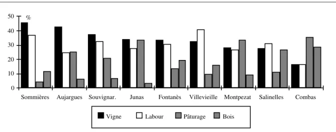
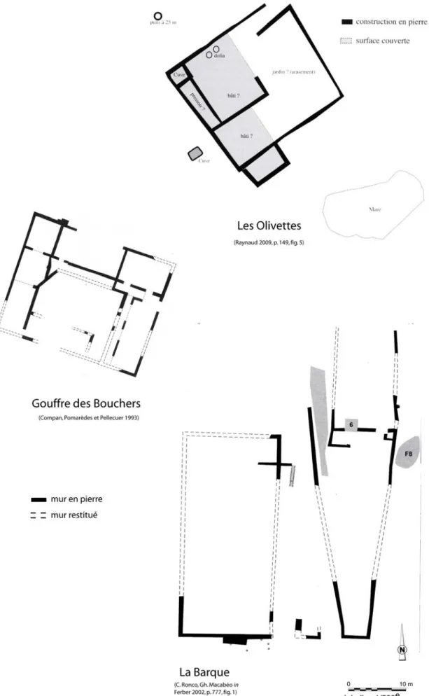
L’espace délimité pour cette étude s’étend sur 70 km² environ ; il est donc plus restreint que ce qui se fait habituellement pour les études micro-régionales en archéologie. Située dans l’arrière pays languedocien, à une trentaine de kilomètres de Nîmes, chef-lieu de cité dans l’antiquité, la zone d’étude est l’un des espaces les plus densément fournis en sites archéologiques. Le corpus d’établissements présente la particularité de compter plusieurs sites d’artisanat (du fer et de la terre) en milieu rural - ce qui est assez rare dans les données de prospection en Languedoc oriental. Cet espace offre en effet, du point de vue du milieu géographique, des potentialités particulières : il s’agit d’un milieu karstique, longtemps dévolu au pastoralisme, et qui comprend des ressources minières et minérales non négligeables. En premier lieu, la pierre du massif du Bois des Lens, un calcaire de premier choix pour la taille de pierre, qui occupe une place importante dans les constructions des agglomérations de la cité de Nîmes (Bessac 1996). L’artisanat de la terre et du surtout du fer pour les périodes étudiés est également présent dans ce massif calcaire, mais reste encore mal connu - l’étude de l’activité sidérurgique ne fait que commencer (Pagès 2008).
L’étude du système de peuplement de la zone d’étude peut donc être abordée sous de nombreux aspects. Cette étude se concentre sur deux axes de recherches, orientés sur l’analyse croisée des formes d’occupation et des potentialités agronomiques offertes par l’environnement physique d’une part, et les conjonctures produites par l’environnement humain, au travers du réseau de communication, d’autre part.
L’analyse des relations entre trame des établissements et ressources agropastorales s’est articulée sur trois questions méthodologiques : de quelle manière confronter la position des lieux de peuplement et d’activité avec ce type de ressource ? Comment considérer ces ressources (structurer l’information disponible) ? Quelles sources d’information sont adaptées à l’étude du contexte agraire antique ? La confrontation entre l’évolution de la trame de l’occupation et les potentialités agronomiques nécessite en effet l’élaboration d’une banque de données géographiques adaptée aux spécificités archéologiques. En l’absence de données paléo-environnementales, ce sont les données disponibles sur le milieu actuel qui sont mises à contribution, en les rapportant aux traces d’exploitations anciennes. L’analyse de la relation homme/environnement est donc orientée dans le sens des possibilités offertes et contraintes imposées par le milieu, dans le cadre des pratiques agropastorales. Ce type d’approche nécessite néanmoins d’aborder le milieu physique avec précaution. Dans cette étude, la caractérisation des potentialités agronomiques du milieu sera en grande partie menée grâce aux traitements d’images satellitaires.
L’objectif de l’étude du réseau de communication est d’appréhender le poids du contexte régional sur l’évolution d’un système de peuplement étudié à grande échelle ; c’est un moyen d’évaluer les modalités de l’insertion dans la trame du peuplement régional. L’analyse est ici essentiellement basée sur la modélisation des réseaux viaires. L’approche adoptée consiste à reconstituer la structure de ces réseaux, par le calcul des cheminements optimaux entre les établissements archéologiques. La simulation de voies de communication est une méthode assez souvent utilisée en archéologie, mais les aspects dits techniques sont malheureusement trop souvent éludés. Une partie de ce travail a donc été consacrée à l’exploration de ce type de méthode.
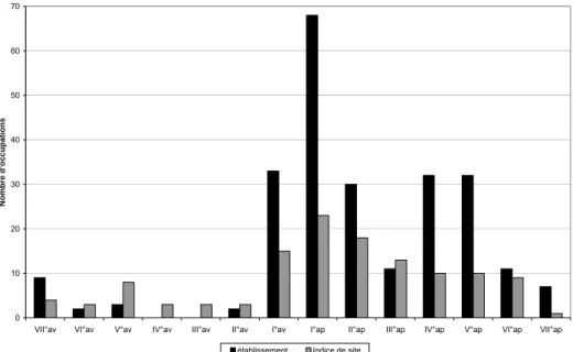
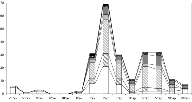
La présentation de ces deux axes de recherches sera précédée d’une étude fine de l’évolution de l’occupation du sol dans l’espace d’étude. Cet état des lieux s’attachera tout d’abord à montrer les traits généraux et les particularités du corpus. Ensuite, la distribution spatiale des établissements, les unités qui structurent le peuplement, sera analysée tout au long des quatorze siècles qui nous occupent. Chaque étape de cette analyse sera l’occasion de situer la zone d’étude dans le contexte régional, d’appréhender la place qu’occupe ce secteur dans le peuplement du Languedoc oriental.
Mais dans un premier temps, il convient de présenter plus en détail le contexte géographique et archéologique de l’étude, en commençant par celui de la recherche en Languedoc oriental, une région qui, de longue date, est le lieu d’une intense activité scientifique.
1.1
E
TAT DE LA QUESTION
Le peuplement ancien du Languedoc oriental est aujourd’hui très bien connu puisque de nombreuses recherches archéologiques ont été effectuées ces dernières décennies, et que les études d’archéologie spatiale ont été précoces dans cette région. Il convient donc de présenter brièvement ces travaux, car ils expliquent en partie le choix de la problématique et des axes de recherches adoptés dans cette étude de doctorat. Bien que la recherche en Languedoc oriental s’inscrive bien évidemment dans le cadre plus général du développement de la recherche archéologique (notamment l’archéologie agraire), ce chapitre traitera uniquement des travaux réalisés dans le cadre restreint de la région qui englobe le secteur d’étude.
1.1.1 Etat des recherches archéologiques en Languedoc oriental
De nombreuses microrégions du Languedoc oriental ont bénéficié très tôt de l’attrait des archéologues pour les vestiges apparents de l’époque préromaine. En effet, et en partie grâce à la proximité de Nîmes où se développa une émulation scientifique précoce, les principaux oppida y ont été découverts et explorés dès le XIXe siècle. Ces premiers travaux d’inventaire, parfois enrichis de réflexions typologiques, laissèrent la place, dans les années 1960 à 1990, à la réalisation de tout un ensemble de fouilles programmées sur les grands habitats de l’Age du Fer (Py 1990 ; Fiches 1989). Ces opérations aboutirent à une très bonne connaissance de la culture matérielle de cette période et de l’organisation interne de ce type d’occupation.
Dans le cadre de ces programmes scientifiques, les recherches ne se limitent plus aux vestiges en élévation, elles englobent l’environnement du site, avec la mise en place d’analyses portant sur les paléosols, la circulation des cours d’eau, et le couvert végétal ancien - ce qui nécessite l’intervention d’équipes pluridisciplinaires. Cette conception nouvelle du site a également débouché sur l’étude de son contexte humain par prospection pédestre.
Parallèlement, la Préhistoire récente a également bénéficié d’une recherche systématique depuis les années 1970, tandis que les études concernant les périodes antique et surtout médiévale restaient relativement modestes, se cantonnant à des travaux d’inventaires (découvertes fortuites et textes médiévaux) et de prospections pédestres très localisées ; ils