HAL Id: hal-02594137
https://hal.inrae.fr/hal-02594137
Submitted on 15 May 2020HAL is a multi-disciplinary open access
archive for the deposit and dissemination of sci-entific research documents, whether they are pub-lished or not. The documents may come from teaching and research institutions in France or abroad, or from public or private research centers.
L’archive ouverte pluridisciplinaire HAL, est destinée au dépôt et à la diffusion de documents scientifiques de niveau recherche, publiés ou non, émanant des établissements d’enseignement et de recherche français ou étrangers, des laboratoires publics ou privés.
Building a Wetland Management Game for Awareness
Raising and Negotiation Support
F. Milhau
To cite this version:
F. Milhau. Building a Wetland Management Game for Awareness Raising and Negotiation Support. Environmental Sciences. 2010. �hal-02594137�
Building
a
Wetland
Management Game for
Awareness Raising and
Negotiation Support
Juin 2010
François Milhau
Centre de Montpellier
361 rue Jean‐François Breton – BP 5095 34196 Montpellier cedex 05 CemOA : archive ouverte d'Irstea / Cemagref
CemOA
: archive
ouverte
d'Irstea
Building a Wetland Management Game for
Awareness Raising and Negotiation Support
François Milhau
Student in agronomy engineering at Montpellier SupAgro (France)Internship supervisor: Dr Sylvie Morardet, senior economist (UMR G‐EAU, Cemagref, Montpellier, France)
CemOA : archive ouverte d'Irstea / Cemagref
CemOA
: archive
ouverte
d'Irstea
Acknowledgments
Acknowledging all the great people I met during my stay in South Africa would need a report on its own, so I will have to keep it brief for this time… First, I think I have to thank my supervisor during this internship, Sylvie Morardet from Cemagref. Thanks for giving me the opportunity to work on a really interesting project in an amazing country, and for all your support on my job. What I discovered here will remain as a unique experience for me, and I hope to get the opportunity to come back there. Then, when it comes to the people I met in South Africa, from a chronological point of view, I will thank the CRCE staff, Ernest, Koke, Tumelo, Shiba, Makgabe, Mashapa, our cleaning lady mother… for their welcoming and their good spirit no matter the time of the day. Masingi, you did not stay as long as I was hoping for, but I really enjoyed your views and your friendship. Thanks to Koke for the unforgettable trips to Mafefe, when we used to take our time to enjoy the journey… Tumelo, you also helped me a lot during my stay, and I had some nice time in Ga‐Mampa talking with you about everything and nothing. On the Ga‐Mampa side, big thanks to Bernard who welcomed me warmly and introduced me to the village and its people. Without you, things would have been way more difficult! I will not mention the names of all the villagers who came to my meetings, but I really appreciated to have discussions with them. I hope my work will be helpful for their village! And then, come all the other persons I had the opportunity to meet and who helped me a lot to feel comfortable every time. First would be Doctor Jo, who introduced me to South Africa and made me discover and understand a lot about this country. All my thoughts also go to your family, who welcomed me so nicely every time. I don’t and I won’t forget Gavin and Rika, second family and crazy fishing weekend organizers and braai masters! All my friendship goes as well to Alana and Britney, whom I enjoyed talking to. And then, to all these people I met around the country, wherever, whenever, and who always welcomed warmly this Frenchy going around South Africa! CemOA : archive ouverte d'Irstea / CemagrefABSTRACT
Wetlands are ecosystems of crucial importance as it supports specific flora and fauna. However, laws and public policies often tend to overlook their importance, threatening their conservation. This is especially true in developing countries when there is no strong will from governments. The WETwin project aims at enhancing the role of wetlands in an integrated water management context. One of the case studies of the project is located in Ga‐Mampa, a small South African village. Role‐playing games (RPGs) are emerging as a useful tool when it comes to natural resources management issues. They are able to integer the diversity of opinions among stakeholders, making them a sound support for discussions and decisions. Thus, the International Water Management Institute, partner of WETwin, and the Cemagref started developing their own role‐playing game, called Wet‐Wag. It aims at supporting negotiations and raising stakeholders’ awareness on environmental issues.
A four months mission in South Africa was made to develop Wet‐Wag further. The objectives were to learn about stakeholders’ concerns so that the game can meet their expectations; to test the game and see what works and what is missing; and to include relevant elements that were missing (such as crops). A review of reports made on Ga‐ Mampa gave a first appraisal of the situation in the village. Ga‐Mampa is described through its economic and environmental characteristics. We discover a poor village in a remote valley in North‐Eastern South Africa. The wetland is getting more and more encroached through the years. Thus, local government and research institution began working together with the community to design a management plan for the wetland. Articles on RPGs were then studied to learn the important points to be considered in games. Many researchers used games to help in NRM processes. They use different levels of abstraction to simplify the reality of the situation and make it easier to understand. RPGs are often part of a collective process, where all the stakeholders are given the same importance and can have a say in things.
Participatory methods such as focus group discussions were conducted in the village to learn about farmers’ concerns. Personal interviews were done with external stakeholders for the same purpose. The outcome is that farmers are especially worried about the poor irrigation scheme and the difficulty to sell their products. Administrative authorities are more concerned by environmental protection. New elements were thus designed in the game. A sheet was created to monitor the wetland health. Data for new crops were obtained through personal searches and 3 new crops were added in Wet‐Wag. The new version of the game also offers participants to take collective decisions. However, the game is not complete. Recommendations are also made for the future use of the game. CemOA : archive ouverte d'Irstea / Cemagref
List of abbreviations and acronyms
CDF: Community Development Forum CRCE: Centre for Rural Community Empowerment CNEARC: Centre National d’Etudes Agronomiques en Régions Chaudes DWAF: Department of Water Affairs ENITAB: Ecole Nationale d’Ingénieurs des Travaux Agricoles de Bordeaux G‐EAU: Gestion de l’Eau, Acteurs et Usages GIS: Geographical Information System IRC: Institut des Régions Chaudes IWMI: International Water Management Institute LDA: Limpopo Department of Agriculture LEDET: Limpopo department of Economic Development, Environmental affairs and Tourism NGO: Non‐Governmental Organization NRM: Natural Resources Management PTO: Permit To Occupy RPG: Role‐Playing Game SANBI: South African National Biodiversity Institute UNDP: United Nations Development Programme WAG: Water Allocation Game CemOA : archive ouverte d'Irstea / Cemagref
Table of contents
Acknowledgments... ii List of abbreviations and acronyms ... iv Table of contents... v Table of illustrations...vii 1 INTRODUCTION ... 1 2 KEY FEATURES OF THE GA‐MAMPA STUDY SITE ... 3 2.1 Geographical features of the valley of Ga‐Mampa ... 3 2.1.1 Location within South Africa and surroundings... 3 2.1.2 Climatic conditions in Limpopo and the village ... 5 2.1.3 The Ga‐Mampa wetland... 6 2.2 Social and economical appraisal of the valley... 8 2.3 Agriculture in the valley: irrigation and wetland cultivation... 9 2.3.1 Agriculture overview ... 9 2.3.2 Cropping systems in the irrigation scheme and the wetland ... 10 2.4 Stakeholders involved in the Ga‐Mampa study site... 13 3 ROLE‐PLAYING GAMES IN NATURAL RESOURCES MANAGEMENT CONTEXT... 16 3.1 Overview of role‐playing games ... 16 3.1.1 Definition and basics concepts of RPGs ... 16 3.1.2 Interest of RPGs for environmental management... 17 3.1.3 Building a functional RPG ... 18 3.2 Wet‐Wag, a role‐playing game for wetland management... 20 3.2.1 Origins of Wet‐Wag... 20 3.2.2 Objectives, elements and rules of Wet‐Wag ... 20 4 Developing Wet‐Wag in South Africa... 27 4.1 Objectives of the research in South Africa ... 27 4.2 Description of the methods used during the internship ... 28 4.2.1 Review of the reports made on Ga‐Mampa ... 28 4.2.2 Focus group discussions ... 29 CemOA : archive ouverte d'Irstea / Cemagref4.2.3 Interviews with external stakeholders... 31 4.2.4 Game testing sessions ... 31 4.2.5 Additional data collection ... 32 5 Results, modifications of the game and way forward ... 34 5.1 Modifications and new elements for Wet‐Wag ... 34 5.1.1 The issues to be tackled by the game ... 34 5.1.2 The roles in Wet‐Wag: relevance and additions ... 40 5.1.3 Developing new actions for the game ... 41 5.1.4 Simplification and changes in the design of the game ... 42 5.1.5 Event cards ... 46 5.2 Feedback on the methods used ... 46 5.3 Way forward and recommendations ... 47 REFERENCES ... 51 APPENDICES... 53 CemOA : archive ouverte d'Irstea / Cemagref
Table of illustrations
Map 1: the nine provinces of South Africa and the neighbouring countries (Source:
wikipédia) ... 3
Map 2: The Limpopo province and its different districts displayed with different colours (source: http://www.limpopo.gov.za/about_otp/images/limpopo_map.jpg). Zoom: aerial picture of Ga‐Mampa, the blue line representing the limits of the village and the yellow one the road crossing it (Source: Google Maps)... 4 Figure 1: Average climatic conditions in the Capricorn District (data gathered from 1961 to 1990 by the South African Weather Service) (Source: Adekola, 2007) ... 5 Figure 2: Drawing of the irrigation scheme of Fertilis (Source: D. Chiron, 2005) ... 11 Figure 3: Land use change in the Ga‐Mampa valley between 1996 and 2004 (Source: Sarron, 2005)... 12 Figure 4: Stakeholders interactions in the Ga‐Mampa project (Source: Y. Darradi, 2005) ... 13 Figure 5: Game boards of Wet‐Wag... 22 Figure 6: Role description card in Wet‐Wag ... 23 ... 24 Figure 7: Example of action card in Wet‐Wag... 24 Figure 8: water units and money units during a game session (Source: F. Milhau, 2010) ... 25 Table 1: Objectives of the internship in South Africa ... 27 Figure 9: Decision card “Rehabilitation of the irrigation scheme” ... 35 Figure 10: Decision card “Building a new irrigation system”... 36 Box 1: the wetland health record monitoring sheet... 38 Box 2: wetland conditions designed for Wet‐Wag ... 39
Figure 11: Comparison between the old role card for irrigator 1 (top) and the old one (bottom) ... 43
Figure 12: Comparison between the old action card for coriander (left) and the new one (right)... 44 Figure 13: Groundnut action card ... 45 CemOA : archive ouverte d'Irstea / Cemagref
1 INTRODUCTION
Wetlands are ecosystems of crucial importance, as they are the support for specific plants and animal species and provide numerous services to the populations living next to them, ranging from water and plant collection to flow regulation and flood protection. However important they are, their fragility makes them especially sensitive to drivers of change and external pressures such as climate change and population growth. Moreover, wetlands generally fall in the gaps of the regulation, their dual nature both terrestrial and aquatic putting them at odds with traditional rules for river or land. As a consequence, new management solutions should be designed, involving the cooperation of all stakeholders, from the community level to the institutional level.
The WETwin project has the objective “to enhance the role of wetlands in basin‐scale integrated water resources management with the aim of improving the community service functions while conserving good ecological status”, as written in the project description1. This project gathers scientists with different backgrounds such as ecology, economy, hydrology or agriculture, from research institutions and consulting companies. As stated above, they try to facilitate the process of wetland conservation, integrating the views from stakeholders and enhancing the discussion between those different partners. WETwin studies wetlands all over the world, in both developing and developed countries. Those sites spread from Europe (Austria, Hungary), Mali (Inner Niger Delta), Uganda to Ecuador. A complete description of the project can be found on their website (see footnote n°1).
To meet the challenge of successfully integrating the diversity of viewpoints into management plans, researches were conducted to develop new tools for natural resources management (NRM) issues. Role‐playing games (RPGs) are one of those tools used to enhance participation and discussion. They try to reconcile the “traditional” top‐down or bottom‐up approaches previously in use for NRM into a collective learning process where every stakeholder has a say in things (Barreteau et al., 2007a). The French research centre Cemagref, supported by the International Water Management Institute (IWMI) is currently developing its own model of RPG with the objective of providing an efficient support for awareness raising, negotiation and education. This RPG is called Wet‐Wag and is based on the Water Allocation Game (WAG) also created by Cemagref under the supervision of Nils Ferrand. Wet‐Wag reflects the case of a small wetland located in a South African village called Ga‐Mampa. This place has been surveyed for years by IWMI and the Centre for Rural Community Empowerment (CRCE), an institution part of the University of Limpopo, in order to secure economic development while ensuring environmental conservation. Those objectives are also supported by the provincial government and Non‐Governmental
1
Description found on the internet site of the project: http://www.wetwin.net/about_introduction.html [retrieved on June 2, 2010] CemOA : archive ouverte d'Irstea / Cemagref
Organizations (NGOs). All the stakeholders involved are aiming at designing a management plan for the wetland guaranteeing environmental protection and sustainable livelihoods for the villagers, though they have different priorities and means of action.
In order to improve the existing design of the game and to make it fit to the local situation in the village, I did a four months visit in South Africa to interview stakeholders and test the game. Various participatory methods were used to describe the socio‐economic context and the environmental situation, while searches were done to add relevant elements to the game. The RPG would then be used during the discussion process between the various stakeholders, and could be a helpful tool in other contexts too, in other WETwin sites in developing countries.
The following report gives a description of the context, ranging from South Africa in general to the wetland itself. A review of literature on RPGs is then presented, before the description of the Wet‐Wag game itself. The following part deals with the methods used during the internship to collect data from the stakeholders and get their views on the game, leading to improvements and changes in its design. The report ends with some recommendations for the future developments of Wet‐Wag and its usefulness for other cases. CemOA : archive ouverte d'Irstea / Cemagref
2 KEY FEATURES OF THE GA‐MAMPA STUDY SITE
This part deals with the significant features of the village, going from its geographical situation to a description of the wetland. It is mostly based on previous reports made by former interns from IRC (Institut des Régions Chaudes, ex‐CNEARC) Pierre Ferrand and Damien Chiron, as well as Younès Darradi from ENITAB (Ecole Nationale d’Ingénieurs des Travaux Agricoles de Bordeaux). IWMI also conducted studies to describe the site. The following sections contain only a part of all the data available on the location and socio‐ economic contexts. For further information, one should refer to the aforementioned reports.
2.1 Geographical features of the valley of Ga‐Mampa
2.1.1 Location within South Africa and surroundings
The village of Ga‐Mampa, named after the people living in the area, is located in the Limpopo province, the north‐easternmost province of the Republic of South Africa, bordering Botswana, Zimbabwe and Mozambique. The country is composed of nine provinces, shown on the map thereafter:
Map 1: the nine provinces of South Africa and the neighbouring countries (Source: wikipédia2)
Ga‐Mampa is a rural village located in the Mafefe tribal area of the Lepelle‐Nkumpi Local Municipality of Republic of South Africa. The Ga‐Mampa valley covers a land area of about 5km², stretching along the Mohlapitsi River, while the settlements themselves are spread approximately mid‐stream of the river course. Geographically, it is located on
2 Wikipédia webpage on South Africa: http://en.wikipedia.org/wiki/South_Africa [retrieved on April 19th 2010]
CemOA
: archive
ouverte
d'Irstea
coordinates 24° 7' 0" South; 30° 5' 0" East. The closest town to Ga‐Mampa valley is Tzaneen, which is about 42km away, but road access is very poor. Ga‐Mampa valley is about 120km (that is to say two and half hour drive) and 87km to Polokwane and Lebowakgomo, provincial and municipal capital respectively. The wetland is approximately 120 hectare with a catchment of approximately 40,000 hectare (Kotze, 2005). Map 2 displays the location of the valley within the province and an aerial picture of the village. Map 2: The Limpopo province and its different districts displayed with different colours (source: http://www.limpopo.gov.za/about_otp/images/limpopo_map.jpg). Zoom: aerial picture of Ga‐Mampa, the blue line representing the limits of the village and the yellow one the road crossing it (Source: Google Maps). CemOA : archive ouverte d'Irstea / Cemagref
Ga‐Mampa itself is composed of several distinct settlements spread along the valley, called (from south to north): Gemini, Manthlane, Ga‐Moila (also known as Vallis), Mapagane (a.k.a. Fertilis), and Mashushu. The mountains surrounding the village were declared nature reserves in the 60’s and 70’s. They are called the Wolkberg Nature Reserve on the western side, and on the eastern side the Lekgalametse Nature Reserve. Villagers used to live in these areas, but were expropriated and relocated in Mashushu.
2.1.2 Climatic conditions in Limpopo and the village
Figure 1 shows the average climatic condition in this part of the province, taking its data from the climatic station of Polokwane. However, from a personal experience, conditions in the valley tend to be slightly different, usually experiencing hotter temperatures, fewer rainfall events but of stronger importance. This is just an appraisal of the situation and requires measurements to be proved. Figure 1: Average climatic conditions in the Capricorn District (data gathered from 1961 to 1990 by the South African Weather Service) (Source: Adekola, 2007) A climatic year is composed of two very different seasons: − Wet season, from October to March/April: this is the tropical summer, days are hot and rainfall abundant − Dry season, from May to September, corresponding to the winter. Monthly rainfall is very low, and several weeks can go before rain falls again. Temperature also drops significantly.
As it often occurs in South Africa, evapotranspiration is higher than rainfall leading to bush vegetation (Darradi, 2005). Thus, crops require irrigation, but this can only be done during summertime. Indeed, the water intake in the river is not properly designed, and thus, when the river level lowers naturally during the winter, the irrigation scheme cannot provide enough water. CemOA : archive ouverte d'Irstea / Cemagref
2.1.3 The Ga‐Mampa wetland
Extended descriptions of the wetland were made by Donovan Kotze (2005) when he made his report on the assessment of the wetland health, and by Coralie Sarron (2005) and Mutsa Masiyandima (2006). The wetland occurs in the channelled valley bottom section of the Mohlapitsi River below the Wolkberg mountains. As already mentioned the valley is narrow and confined, with steep hill slopes on the edges of the valley bottom. The wetland is approximately 120 hectares in area. It occurs along the valley floor, extending about 4 – 5 km downstream on both sides of the river as well as within the riverbed in some sections. The maximum width is approximately of 500 meters.
The hydro‐geomorphology of the wetland is described in detail in Kotze (2005). The soils in the wetland are a mix of fine‐textured, poorly‐drained areas away from the river channel, and less extensive sandy soils located close to the channel. The wetland is heavily utilized for agriculture and natural vegetation has been recessing for years due to human pressure. Drainage canals are a major feature of the croplands as the crops grown in the wetland (maize and coriander) do not perform well under saturated or flooded conditions.
The underground hydrology is not very well known, and, despite several studies, the nature of the water flows between the wetland and the Mohlapitsi River are not very clear. However, it is a well known fact that the river has a potential contribution of 10% of the Olifants River’s flow, going up to 16% during the dry season. The Olifants River provides water to a number of industries (mines) and factories, and also crosses the Kruger National Park, one of the largest wildlife reserves in the country. Thus, the Mohlapitsi is of great importance to the region. Water quality in the river is good, relieving the Olifants from the pressure of industries. Map 3 thereafter shows the wetland location and the land use currently observed in Ga‐Mampa. This map was made by Clément Murgue, intern from IRC at Cemagref. One can see that most of the valley is currently under use. The slopes steepness makes them difficult to support new constructions or fields. CemOA : archive ouverte d'Irstea / Cemagref
N
Irrigation system Rain fed agriculture Maize cropping in wetland Water saturated area Wetland Wet area Living area Map 3: Ga‐Mampa valley land use (Murgue, 2010; Kotze, 2005; Sarron, 2004, Google Earth) White: Living areas Green: Irrigation schemes Blue: Wet areas Red: Wetland extent, including: Pink: Water saturated areas Dark shade: Maize cropping extent500 m
CemOA : archive ouverte d'Irstea / Cemagref2.2 Social and economical appraisal of the valley
From an administrative point of view, the village of Ga‐Mampa is part of the ward of Mafefe, in the Lepelle‐Nkumpi Municipality, located in the Capricorn District of Limpopo. The municipal offices are located in Lebowakgomo. However, the village itself is ruled by “traditional authorities”, referring to the Headman (Induna) operating at the village level, and being under the authority of a Kgoshi, based in Mafefe. The Headman is responsible for settling conflicts among people and is the keeper of the traditional habits. A community development forum (CDF) has been created in 1995 by the villagers themselves. It is composed of a board with a secretary and several forums dealing with specific matters such as irrigation, the wetland, health, education and so on. They are in charge of development projects. The secretary of the CDF can refer to the ward councillor, also based in Mafefe, who can then convey information and requests to the municipal offices in Lebowakgomo. All in all, two regulation systems exist in the village, one based on the traditional structure of the society (Headman), the other being the result of the democratic progress in the country. Inhabitants in the valley are black Sepedi‐speaking people. Sepedi (a.k.a Northern Sotho) is one of the eleven official languages in South Africa. Population statistics based on 2001 census figures provided by Statistics South Africa and compiled by Nathalie Tinguery (2005) reveal that in 2001, Mafefe ward 24 had a population of 9217 persons living in 1968 households with a population density of 223 people per km². However, it is difficult to assess the importance of Ga‐Mampa in these figures. In her report, Tinguery reckoned that the whole Ga‐Mampa valley accounted for 1679 persons (18% of the total in the ward) and 327 households (17% of the total in the ward). Later studies by Olalekan Adekola (2007) derived the total population from field study and gave a figure of 2364 persons in 394 households for the valley in 2007. This would mean an increase of 45% in a few years period, which is highly unlikely given the socio‐economic features of the valley (AIDS, lack of space).
During the apartheid era, Ga‐Mampa was part of the homeland of Lebowa, whose capital city was Lebowakgomo. This explains some of the key features of the village today. Homelands were places for black people, accounting for approximately 80% person of the population of South Africa, on only 20% of the territory. Currently, the area is still overpopulated and poverty alleviation is one of the main challenges. Poor infrastructures and public services (road access, healthcare) are holding back the development of the region. Ga‐Mampa is approximately a 2 hours drive from Polokwane, as the last kilometres of the road are not tarred. This track then goes to Tzaneen, but only 4x4 vehicles can drive on this narrow and difficult path. The condition of the track is badly altered after each rainfall event, as puddles can last for weeks while heavy vehicles circulate. Few public transports (government buses, taxi to Lebowakgomo) serve the village. Telecommunications are almost non‐existent, as there is only a public phone in bad condition and very scarce network for mobile phones, though many people own one. Most houses are connected to CemOA : archive ouverte d'Irstea / Cemagref
the electricity, but water has to be taken from public taps and stored in the house. There are basic education facilities, going from pre‐school (crèche) to a secondary school, but children have to leave the village if they want to attend higher education.
Agriculture is the main source of income and employment for most households, along with external sources of income such as social grants and remittances from family members working outside the village. A growing number of men are going to the neighbouring cities to find a job, while women stay in the village to take care of the family and crop in the fields. Though there are no data available on these topics, Darradi stated that unemployment is at a high level, and AIDS is taking a great toll on the workforce of the village (Darradi, 2005). A drop‐in centre is managed by a group of women to take care of orphans.
2.3 Agriculture in the valley: irrigation and wetland cultivation
2.3.1 Agriculture overview
As shown above on figure 1, the climate divides the year in two very different seasons, which influences the crops planted in the fields. During the wet season, farmers mostly plant maize, which is the basis for meals in this area. Other crops used are pumpkin, often intercropped together with maize, sweet potatoes, tomatoes and groundnut. During the winter (dry season), main crops are cabbages, onions, coriander, beetroot and dry beans. Some perennial cultures can also be found as a complement on the border of the fields. This is the case of sugarcane, avocado trees, mango trees and pawpaw trees.
Agriculture is mainly subsistence agriculture, at a small‐scale level. Farmers own rather small plots. According to Chiron (2005), the average plot size for a family is around 1ha. However, this assessment is only partial: some families also own a private garden next to the house, which is used for cropping (spices, vegetables, and maize). Masclet (2007) assessed the average size for homestead to be around 0,25ha. Moreover, some farmers own a plot in the irrigation scheme and the wetland, whereas others only have access to a field in the wetland. The common size for a plot in the wetland is around 0,75ha (Masclet, 2007). Land scarcity is becoming a constraint for the village. Products are mostly for self consumption. Maize is sent to a milling company to be processed, and the flour is used to prepare the “pap”, a starch meal. A rather small part of the vegetables production is sold to local markets: tomatoes are found in tuck shops, sugar cane sticks are sold in the farmer’s house… The distance and the road bad condition hold back the development of agriculture and its access to the markets. Agricultural equipment is quite poor in the village, but farmers have been using their techniques for decades and now they master them. They use donkeys to plough the soil, but CemOA : archive ouverte d'Irstea / Cemagref
some also purchased tractors to work the soil and carry loads during the harvesting season. Lepelle‐Nkumpi municipality used to help farmers to borrow or purchase tractors, but they withdrew their support while farmers reckon they suffer from a lack of such vehicles (Frank Mampa, personal communication). Otherwise, most of the equipment is composed of manual tools such as hand hoes and shovels, as described by Masclet (2007). He also described this material as old, but the situation varies depending on the household.
2.3.2 Cropping systems in the irrigation scheme and the wetland
Two systems of agriculture are found in the village (as rain fed agriculture is only on a small scale and was not considered during the study, it is not included here). The first one is also the oldest: irrigated fields. Government built four irrigation schemes in the 40’s and 50’s in Gemini, Vallis, Fertilis and Mashushu. The Gemini one, in very poor condition and no longer in use, was not studied but is similar to the other ones. They consist of an intake in the river made of gabions, a main canal (cemented in the case of Fertilis) driving the water from the river to a primary canal, then secondary canals between the fields and at last furrows distributing the water inside the field. A drawing made by Damien Chiron (Chiron, 2005) can be seen on the following page (figure 2), representing the basic organization of the irrigation system. The access to a plot is given through the use of a Permit To Occupy (PTO). It allows a farmer and his family to cultivate a plot in the irrigation scheme. PTOs cannot be sold to another farmer. Such permits are lifelong permits and were allocated in the 60’s. Access to water is overlooked by the water committee within the CDF. Water is distributed to the different plots according to a rotation scheme, stating the days of the week when a farmer can open its furrows and irrigate his fields. However, some farmers mentioned that people can cheat and take some water at night. Water committee is in charge of enforcing this rotation and looking for cheaters.
However, the irrigation schemes are now in a very poor condition. Only the Fertilis one was built with cemented canals all along, the other ones include earth canal in the system. Due to lack of maintenance, those earth canals suffer from siltation and lost most of their efficiency. Moreover, the design of the canals was poorly done, and a number of leakages can be found along the way. Overall, water efficiency in the system is expected to be as little as 6% (Chiron, 2005). The irrigation scheme in Gemini is said to be not functional anymore, but it was not further investigated. CemOA : archive ouverte d'Irstea / Cemagref
F igure 2: Drawing of the irrigation scheme of Fertilis (Source: D. Chiron, 2005) CemOA : archive ouverte d'Irstea / Cemagref
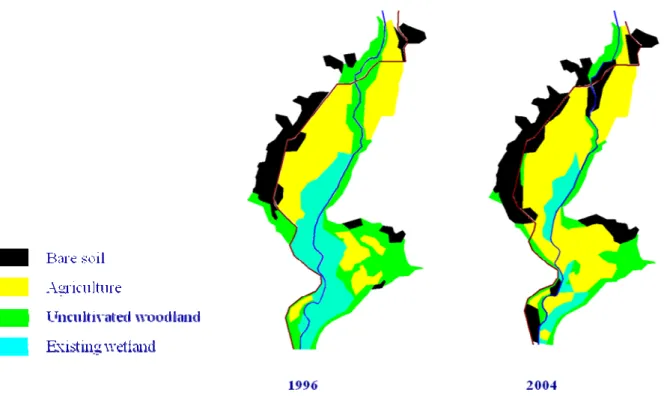
In 2000, a major flood occurred in the region, and greatly damaged the canals and the water intake in the river. As a consequence, some farmers asked the permission to start cropping in the wetland, in spite of the South African laws identifying wetlands as sensitive areas and thus ensuring them a protection. PTOs could not be given, and farmers simply had to ask the Headman if they can have a piece of land in the wetland. This costs about 20 rands3, and farmers receive an oral permission to start cropping. What was at first a move driven by the damages suffered by the irrigation scheme was amplified by the issue of population growth and land scarcity in the narrow valley, and within 10 years time, the natural part of the wetland declined dramatically. In his report, Kotze estimated that crops accounted for 65% of the 120ha, and five years after this figure should be over 80% (personal assessment derived from field observations). Figure 3 thereafter is a GIS map of the land use in the valley, and displays this tendency.
Figure 3: Land use change in the Ga‐Mampa valley between 1996 and 2004 (Source: Sarron, 2005)
“Bare soil” refers to settlements and abandoned areas not cultivated. One can see that agriculture and settlements expanded dramatically, while wetland and woodland are left in few parts, the most difficult to reach.
When farmers moved from the irrigation scheme to the wetland, they had little knowledge on farming in those specific conditions, so they began using the same methods they applied in the irrigated plots. They dug drains and burnt natural vegetation, practices known to oxidize soil organic matter (SOM), thus provoking its depletion. Clearing of natural vegetation (reeds and sedges) also proves to be harmful, as it takes several years to recover 3 The rand (ZAR) is the money unit in South Africa. In June 2010, 1 ZAR ≈ 0,10 € CemOA : archive ouverte d'Irstea / Cemagref
after the wetland is left undisturbed. Families collect such plants for the making of crafts and roofing.
2.4 Stakeholders involved in the Ga‐Mampa study site
IWMI started research in the village in 2005 and later on included this wetland as part of the WETwin project. As stated in the introduction, IWMI aims at developing a sustainable wetland management plan to protect the wetland ecosystem while guaranteeing a reasonable level of livelihoods for local households. Meanwhile, UNDP has recently provided funds for the community, carrying the same spirit of environment conservation and social concerns. IWMI made a stakeholder analysis at the beginning of the project to identify all the people and institutions concerned. Figure 4 below illustrates the various stakeholders and their inter‐linkages, which are detailed after on. Figure 4: Stakeholders interactions in the Ga‐Mampa project (Source: Y. Darradi, 2005) Here is a brief description of each stakeholder presented in figure 4. In yellow colour: − National government − Provincial government of Limpopo − Capricorn District Municipality CemOA : archive ouverte d'Irstea / Cemagref− Local Municipality of Lepelle‐Nkumpi (offices for Agriculture, Environment and Tourism) − Ward councillor (WC), government representative in the ward of Mafefe In green colour, stakeholders linked with agriculture: − National Department of Agriculture (NDA) − Limpopo Department of Agriculture (LDA) and the Landcare programme, interested in soil and water conservation − The extension officer (EO) working in Ga‐Mampa, providing technical help − The RESIS programme supporting rehabilitation of small irrigation schemes In blue colour, stakeholders working with water and environmental conservation:
− Department of Water Affairs (DWAF), responsible for rivers’ condition and water resources management at national and provincial levels − Department of Environmental Affairs and Tourism (DEAT), in charge of the protection of natural ecosystems − The Mondi Wetland Project (MWP), financing actions to protect wetlands − The Kruger National Park (KNP), one of the largest and most visited wildlife reserves in South Africa In purple, the research organizations:
− IWMI South Africa, an international research organization working for sustainable water management
− CRCE, an outreach institution aiming at facilitating empowerment process for rural communities, working at Ga‐Mampa for 10 years. It is hosted by the University of Limpopo
The traditional authorities of the valley are presented in orange colour. In pink colour, the stakeholders within the community itself:
− CDF of Ga‐Mampa and the Wetland Committee, representing the interests of the community
− Livestock owners and cultivators, representing the two kind of farmers in the village At last, in white there is the Working For Wetlands (WFW) programme, a division of a more general programme called Working For Water and created by DWAF. WFW works specifically on wetland rehabilitation. The Olifants River Forum (ORF) is an association including the main water users of the Olifants River basin. Three stakeholders were omitted in figure 4: CemOA : archive ouverte d'Irstea / Cemagref
− Limpopo Department of Economic Development, Environment and Tourism (LEDET), in charge
− South African National Biodiversity Institute (SANBI), partner of the Working for Wetlands programme
− UNDP, financing conservation projects, now giving money to the CDF and the LDA to impulse projects
A large number of stakeholders are involved, and there are potential tensions among them. The CDF and the Headman, represent two sides of the authority on the Ga‐Mampa valley. Since the creation of the CDF, the power of the Headman has been progressively eroding, thus leading to conflicts between them. Within the farmers, cultivators and livestock breeders have different interests. The former want grazing areas close to the village and were used to put their animals in the wetland, while the latter want to extend their fields and cannot tolerate the presence of cattle near their cultures. The last potential tension illustrated in figure 4 results from a misunderstanding between the Mondi Wetland Project and the community. When MWP became interested in the wetland in Ga‐Mampa, the community thought they were going to expulse farmers from their plots, leading to tensions between MWP and the community.
The village of Ga‐Mampa is a remote area located in a rural part of South Africa. Poor road infrastructures and network connection hamper its development and trading with neighbouring places. Agriculture is the main source of income for most households. Small‐ scale agriculture occurs in old irrigation schemes and, for ten years, in the wetland. Agriculture in the wetland was driven by population growth and the inadequacy of the irrigated fields. Most of the natural wetland has been cleared and burnt over the past years, and now it is dedicated to agricultural plots, thus depriving population from other services provided by wetlands (e.g. plant collection). As stakeholders (both external and internal) are now struggling to preserve the wetland, it is necessary to find tools for facilitating discussions among people with different interests. To find a balance between environmental protection and social well‐being, the use of RPG in natural resource management has developed for years and many authors recommend it. The next part of this report will provide the reader with an overview of the developments in this area. CemOA : archive ouverte d'Irstea / Cemagref
3 ROLE‐PLAYING GAMES IN NATURAL RESOURCES MANAGEMENT
CONTEXT
3.1 Overview of role‐playing games
Various authors are working on role‐playing game, and literature on this topic is quite abundant. The use of games to represent real‐life situation is rather old, and find its origins in old German war games from the 19th century (Duke and Geurts, 2004). However, using games in natural resource management context is quite new, as one of the first games designed for this purpose was the River Wadu Role‐Playing Game made by I.D. Carruthers in 1981 (Dionnet et al., 2006). Since then, the use of RPGs has been extending in several fields and for various purposes.3.1.1 Definition and basics concepts of RPGs
RPGs are defined as “a goal‐directed activity conducted within a framework of defined rules, involving characters who role‐play” (Dionnet et al., 2008). Games are made for a specific purpose, in order to answer a scientific question or to solve a real‐life dilemma. The purpose is known for the developer of the game and must be stated when it is used later on. Specific actions done in the game must fall within the limits set by the rules, defined by the game designer. Several degrees of strictness can be set, depending on the game: a RPG designed for creating management options will leave as much freedom as possible, while others will constraint the player according to a scenario. The last important feature is the use of pre‐defined roles, putting some distance between the player’s behaviour during the session and his (or her) real‐life personality. The possibility to say “it was just a game” always exists (Barreteau et al., 2007a), stripping what happened during the game of any link with the real situation. This link is made during the debriefing step at the end of the session. The manager gets the participants’ feedback of the session, and tries to make them project the results of the RPG to the real life. In the case of a game testing scenarios, players saw what the consequences of their decisions are, providing them with a basis for further discussions. For the manager, this step is the opportunity to see what the players thought of this experience and think on elements that could be improved in the RPG.
Games differ from simulation in several ways. A simulation represents the testing of the choices of participants through a model, which is nowadays often a computer‐based model. Simulations try to grasp the complexity of reality, while games can offer a simplified image of it. Simulations need to be able to represent correctly situations from the past to be validated, and thus make predictions for the future (Meadows, 2001). On the other hand, games start from a given situation, which is almost always the present situation (or at least resembles it, due to simplification). This is due to human players interacting during a session of the game; they cannot stick to a scenario already written. However, Meadows (2001) pointed out that simulation and RPGs can work hand in hand. In his study, he used a game to CemOA : archive ouverte d'Irstea / Cemagref
make people aware of the underlying composition and functioning of the model he used to make simulations at first. In this case, the game functions as a popularization for the simulation, it broadens the audience of the model to non‐specialists.
Games vary a lot depending on the context. The support used can either be a classic board (Water Allocation Game of Nils Ferrand in 2005, River Basin Game by Lankford and Sokile in 2004) as in traditional party games, a computer (e.g. BUTORSTAR, developed by Mathevet et al., 2007), a video support (VPA‐KERALA, developed by Witteveen and Enserink, 2007)… or a mix of several media. Most games are played with physical participants, but computer‐based ones allow the use of artificial intelligence to create virtual players.
3.1.2 Interest of RPGs for environmental management
NRM issues often involve conflicting uses of a resource by several stakeholders, who hardly share a common vision regarding the resource. Interactions between stakeholders are especially difficult to represent in “traditional” simulation approaches based on computerized models. Thus, there is a need for a tool able to simplify the reality and allowing the discussion to focus on the main problems. The RPG is part of a collective learning process where stakeholders are also part of the modelling process and can influence its design and its use (Barreteau et al., 2007a, Lankford et al., 2004). This approach allows multiple exchanges, gaining insights from different points of views. Researchers benefit from stakeholder’s field experience, while local stakeholders can take advantage of scientific expertise. Bots & Van Daalen (2007) also underline that RPGs are able to represent non‐rational behaviours of human beings, something that cannot be done with classic computer models. Those special features of RPGs make them a useful tool for NRM contexts, where human interactions are complex and multiple.
Role‐playing games can fulfil diverse functions according to the needs of the context. Bots & Van Daalen (2007) listed six different categories, but other authors give different ones:
− Research and analysis: the system cannot be studied or is difficult to study because of its complexity, and the game is used as a scientific experiment to generate data on this system
− Design and recommend: building scenarios and alternative solutions to a problem, and possibly trying to figure the consequences of these
− Provide strategic advice: advise on the efficient strategy to be followed, by looking at other players’ reaction
− Mediate: players (potentially stakeholders of a real project) use the game as a virtual negotiation table. The environment of the game, different though similar to the real life, is expected to help raising fresh ideas
− Democratize: all the stakeholders are given the same importance during the process of the game, and all their views are equally considered CemOA : archive ouverte d'Irstea / Cemagref
− Clarify values and arguments: compared with a real‐life situation, the game allows the focus of the discussion to shift from political consideration to values and arguments
Role‐playing allows participants to change their point of view on the subject of the game, and try to gain new insights of the situation. Endorsing news arguments, possibly arguments one used to dismiss in the real‐life can make stakeholders grasp the diversity of viewpoints and the difficulty to balance them (Barreteau et al, 2007b; Bots & Van Daalen, 2007). Games provide a common experience for stakeholders, and they can refer to it in the future for their negotiations. It has even been reported in some cases that participants discovered stakeholders when playing a game. Bots also considers the environment of the game to be fruitful for discussions, as it removes some problems existing in the actual situation.
3.1.3 Building a functional RPG
Two phases are to be distinguished when designing a RPG, the first being the design of the game itself and the second the sequence of a session of the game (playing the game).
A RPG is designed for a specific purpose, as Bots and Van Daalen list it (see §3.1.2 above), thus one should state clearly at the beginning what are the objectives of the game: do we want to raise awareness on a specific issue? Do we want stakeholders to negotiate? Do we want stakeholders to develop their own scenarios for NRM? When those questions (and others) are answered and the purpose of the game is known, the medium of the game can be chosen. As mentioned in the previous section (3.1.1), various supports exist for games. Choosing one should not be overlooked, as it has consequences on the future use of the game itself. For example, a computer‐based game in rural places could prevent some people from participating in sessions, as it requires a certain education. That is why Dionnet et al. (2008) underline that one should study the acceptability of a RPG by stakeholders. The second element designed is the roles for the players. The designer chooses who will be represented among the stakeholders of the project. The second question will be how many of each category will be represented. A game involving many players ensures a large participation from various stakeholders, but the session can become quite confused if not properly supervised. Then, a role needs to get assets and resources to play the game, in terms of money, fields owned, social position, etc… And at last, the definition of a role will be complete when each player knows what the actions he can undertake are. The definition of those actions greatly influences the timeframe of the game. If many actions have to be done during one round, it is expected that only few rounds will be played during a session.
Then, the question will be: what environment will be represented? Generally speaking, the starting point is a real‐life situation that is more or less simplified to suit the purpose of the game. The River Basin Game of Lankford (2004) depicts a highly simplified
CemOA
: archive
ouverte
d'Irstea
cultivated catchment, comprising only a riverbed and fields; while BUTORSTAR represents a virtual wetland with different land use and types of land ownership (Mathevet et al., 2007). The last step corresponds to the second phase of the implementation of a RPG, when the focus shifts to the sequence of a session. There must be facilitators (or game managers) RPG to supervise players and to see to the proper progress of the game. The manager is the keeper of the rules and makes them explicit at the beginning of the session. He (or she) also has to keep the focus of the game, balancing the discussion among participants and the respect of the timeframe set before the session. Each step of the game has to be timed to ensure the proper progress of the session. The spatial setting of the room is also important, and there can be places for participants to discuss among themselves, in order to be not heard by the manager or other participants. The manager is also responsible for the debriefing of the session, when the discussion shifts from the game to the real‐life situation which served as the basis for the RPG. The debriefing also proves to be helpful for designers as it allows a feedback on the experience. Before being functional, a game has to go through several tests to make changes that will shape it step by step, making it meaningful for the study case. An interesting feature of RPGs is their flexibility. Authors agree upon the importance of this (Barreteau et al., 2007a, Dionnet et al., 2008, Bots & Van Daalen, 2007). The game designers have to choose a level of abstraction, which often depends on its purpose. Through simplification, one can make the issue more accessible to every stakeholder, while a higher level of complexity can prove useful for education. The designer, by setting the rules and the roles, can also influence the openness of the storyboard. For example, ATOLLGAME by Dray et al. (2007) allow players to create new rules as the session goes on. The more open the storyboard, the more personal input the players can give. This can help raising new ideas and concepts during the testing of a scenario. Designing a RPG has to be thought carefully according to the purpose of the game, and it can evolve according to participants responses during the sessions. However, it has to be pointed out that the success of a RPG session depends greatly on logistics. Lankford & Watson (2007) underline that great care should be put to the organization of a gaming session, as the choice of time and place can deeply affect stakeholders’ participation. Indeed, the facilitator should be aware of the schedule of each participant in order to find a time convenient for all the players. If the place is located in a remote area, transport may be provided for players who do not have access to a personal vehicle (e.g. farmers).
RPGs are considered a useful tool in the complex context of NRM. Several authors used it and gave recommendations on the designing process. It is widely regarded as
CemOA
: archive
ouverte
d'Irstea
efficient for enhancing negotiation processes and facilitating communication among stakeholders.
3.2 Wet‐Wag, a role‐playing game for wetland management
3.2.1 Origins of Wet‐Wag
As described in the previous part, RPGs are useful for environmental conservation issues, when the situation is complex and requires dealing with several stakeholders. This is the case of the Ga‐Mampa wetland, threatened by human activity (agriculture). As presented in figure 4, many stakeholders are involved and they have very different views on what should happen to the wetland. Thus, IWMI, along with the support of Cemagref decided to set up a RPG designed for wetland issues, based on the Ga‐Mampa case, but which could also be helpful in other case studies surveyed by the WETwin project.
Sylvie Morardet, senior economist at the joint research unit G‐EAU, was in charge of designing. She based her work on WAT‐A‐GAME4 (a.k.a. WAG), a game designed by fellow researchers Nils Ferrand, Géraldine Abrami, Stefano Farolfi from G‐EAU joint research unit and Derick du Toit from the NGO AWARD. WAG’s aim was to facilitate the negotiation process among various stakeholders in the Inkomati catchment. The Inkomati is a transboundary river basin flowing through South Africa, Swaziland and Mozambique. An extended description of this game can be found in Ferrand et al. (2009). To put it roughly, WAG represents a water catchment with different land plots managed by individual players. Players decide how they want to use their land and the amount of resources they take (including water). New rules, in the form of policies and laws, are set during the course of the session, and players have to adapt their behaviour. They can choose to cooperate with each other or not. The objective for each player is to maintain their land activity and livelihood to a viable level (Ferrand et al., 2009). WAG proved to be useful in the case of the Sand River catchment, a sub‐catchment of the Inkomati river basin, in Eastern South Africa. However, WAG fits large catchments and does not focus specifically on wetlands, though they can be part of the game. Thus, the concept of WAG was used as a starting point, but its elements were downscaled at village‐level, and it was focused on wetland management.
3.2.2 Objectives, elements and rules of Wet‐Wag
Wet‐Wag is a board RPG aiming at facilitating the negotiation process in small‐scale wetland conservation projects. It is also expected to help awareness rising, a key issue in NRM projects (Barreteau et al., 2007a). This makes Wet‐Wag potentially useful for educational purposes. 4 See the WAG webpage: http://sites.google.com/site/waghistory/?pli=1 CemOA : archive ouverte d'Irstea / Cemagref
The elements described thereafter were the ones given at the beginning of the study. Further changes will be described in part 5 of the present report. Main elements of the game consist of: − 4 A3 boards representing different parts of the agricultural landscape around a village (irrigation scheme, natural wetland, cultivated wetland, grazing areas) − 6 role cards (one for each player) − 6 sets of action cards − Action (crop, cattle or other action undertaken on a plot), revenue (money units or food units) and manpower tokens (images) − Blue marbles and beads of different sizes standing for water units − Money units in the form of bank notes
Wet‐Wag represents a small rural village in a developing country. This village is located alongside a river, and therefore a wetland that is partly cultivated and partly natural. There is an irrigation scheme taking water from the river, and also grazing areas for cattle in nearby mountains. Figure 5 on the following page shows those four boards, divided into plots.
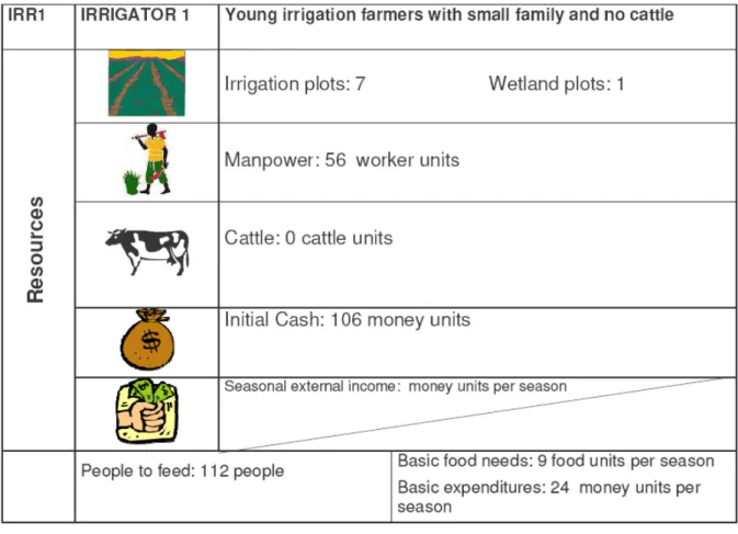
The roles represented in the game are those of farmers who have assets (resources) in the form of plots (either in the irrigation scheme or the cultivated wetland or both), manpower, cattle units and money, i.e. initial cash and money received from external income (social grants, members of the family working outside the village). But they also have needs in terms of money to run their households and food to feed their family. Assets and needs are represented on role cards, such as the one represented thereafter in figure 6. The diversity of roles reflects the reality in Ga‐Mampa. Some farmers have plots in the irrigation scheme, while others are only wetland farmers; some own cattle, some do not and so on. CemOA : archive ouverte d'Irstea / Cemagref
Figure 5: Game boards of Wet‐Wag. Clockwise from top left: the irrigation scheme, the grazing areas, the natural wetland and the cultivated wetland (Illustrations for the grazing areas and the wetland were taken from the Windows on our World: Wetlands game, developed by DWAF, the Department of Agriculture, the Wetland Alliance for Training, Education and Research, the Wildlife Environmental Society of South Africa, SANBI and the Mondi Wetlands Project) CemOA : archive ouverte d'Irstea / Cemagref
Figure 6: Role description card in Wet‐Wag
Money unit is defined in such a way that players do not have to manipulate big quantities of bank notes. It is based on the smallest amount of cash that is exchanged during a game session. It was defined based on economic data collected on the Ga‐Mampa case study by previous researches (e.g. food prices and average crop prices listed in Chiron (2005) and Adekola (2007)). Thus, some economic studies should be done before using the game in another context, to adapt prices level between each other.
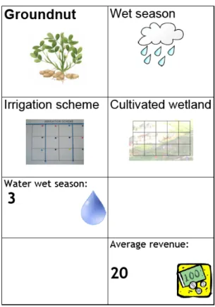
Players can undertake actions on the plots they have been allocated. The game manager distributes at the beginning of the session a set of cards explaining which actions can be done, when they can be done, what are their requirements and their output (payoff). Figure 7 thereafter shows an example of such cards. CemOA : archive ouverte d'Irstea / Cemagref
Figure 7: Example of action card in Wet‐Wag
This is the activity card for coriander when it is grown in the irrigation scheme. As previous researches showed that some crops have different yields depending on whether they are cultivated in the irrigation scheme or the wetland, two cards were done.
Each round in the game represents a season: a wet season or a dry season. Thus, different kinds of activities are available to the players according to the season. During the wet season, the only crop farmers can grow is maize, whereas they have the choice among tomato, coriander, onion and cabbage during the dry season. They can also choose to harvest reeds and sedges in the natural wetland during the dry season. The season also influences the amount of water received by farmers. Small beads and marbles represent water quantities that can be seen on figure 8. CemOA : archive ouverte d'Irstea / Cemagref
Figure 8: water units and money units during a game session (Source: F. Milhau, 2010) Farmers receive water in three different ways: − Water from irrigation scheme: 6 water units are available for each secondary canal in wet season, only 3 during dry season; − Rainwater: only during wet season, the quantity (from 0 to 3 water units) depends on the weather of the year (very dry year, dry year, wet year, very wet year);
− Groundwater: the quantity of water supplied by groundwater is not really materialized in Wet‐WAG. Groundwater is said to provide enough water for the crops in the wetland. It has no influence in the irrigation scheme.
Water feeds the crops planted by each player on his/her plots. To get the optimum yield written on the action card, a player has to provide the number of water units indicated. The game also represents water losses due to the canal poor condition. At the beginning of the session, the game manager explains water circulation from the river to the irrigation scheme and makes clear that 90% of the water is lost through leakages and bad design of the canal. This is also based on Damien Chiron’s measurements. Small beads (1 water unit) Medium beads (10 water units) Bank notes (money units) CemOA : archive ouverte d'Irstea / Cemagref