The days of plenty might soon be over in glacierized Central Asian catchments
Texte intégral
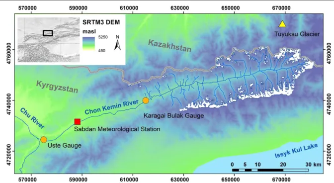
Figure
Documents relatifs
Here, we show correlative in vivo fluorescence lifetime imaging microscopy Förster resonance energy transfer (fLiM-fRet) and stimulated emission depletion (SteD) microscopy to
صخلملا : تامولعلما ةسد هو ايجولو كت ترسام ةيناثلا ة سلا ةبلط دامتعإ ىدم ىلع فرعتلل ةساردلا ذه تءاج ثحبلا تايجيتاترسإ ىلع نماغتسم سيداب نبا
We developed an efficient FEM-RKC method combining the RKC time-stepping method with a spe- cially formulated finite elements spatial discretization to solve two types of PDEs
Une alternative pourrait consister à s’accorder, non pas sur des mécanismes de solidarité sociale entre tous les Européens, mais sur un principe de « partage de la charge »
In Section 5 we construct a selfadjoint realization of the Vlasov- Amp` ere operator, we compute the eigenvalues, and we construct an orthonormal systems of eigenfunctions that
In patients with temporal lobe epilepsies, depolarizing GABAergic events in a minority of subicular pyramidal cells (Cohen et al., 2002) con- tribute to interictal-like
The identity nature of Germany in August Sander’s photographs was precisely what led the Nazi regime to destroy the printing plates of Face of Our Time in 1936.. The
Même dans lès entreprises du secteur des NTIC, entre autres celles des services informatiques, les dépenses consaôrées à la formation et au perfectionnement de la main-d’oeuvre
