HAL Id: hal-01967496
https://hal.archives-ouvertes.fr/hal-01967496
Submitted on 31 Dec 2018HAL is a multi-disciplinary open access
archive for the deposit and dissemination of sci-entific research documents, whether they are pub-lished or not. The documents may come from teaching and research institutions in France or abroad, or from public or private research centers.
L’archive ouverte pluridisciplinaire HAL, est destinée au dépôt et à la diffusion de documents scientifiques de niveau recherche, publiés ou non, émanant des établissements d’enseignement et de recherche français ou étrangers, des laboratoires publics ou privés.
Knowledge management in urban governance; building
adaptive capacity through ICT-GIS-based systems in
the global South
Isa Baud, Karin Pfeffer, John Sydenstricker-Neto, Eric Denis, Dianne Scott,
Luz Consuelo Muguruza Minaya
To cite this version:
Isa Baud, Karin Pfeffer, John Sydenstricker-Neto, Eric Denis, Dianne Scott, et al.. Knowledge manage-ment in urban governance; building adaptive capacity through ICT-GIS-based systems in the global South. Development, Environment and Foresight, Palacký University Olomouc, 2016, 2, pp.2336 -6621. �hal-01967496�
Knowledge management in urban governance;
building adaptive capacity through ICT-GIS-based systems
in the global South
Isa Baud // i.s.a.baud@uva.nl
University of Amsterdam, The Netherlands Karin Pfeffer // K.Pfeffer@uva.nl
University of Amsterdam, The Netherlands
John Sydenstricker-Neto // jmsyden@cebrap.org.br CEBRAP, Brazil
Eric Denis // eric.denis@parisgeo.cnrs.fr CNRS, France
Dianne Scott // diannescott.dbn@gmail.com University of KwaZulu-Natal, South Africa
Luz Consuelo Muguruza Minaya // lcmuguruza@yahoo.es Regional Government of Callao, Peru
Abstract
Knowledge management (KM) in local governance processes is being transformed through digitization (ICT), spatialization (GIS), and participatory processes; the question is whether this increases the potential for building adaptive capacity and inclusivity. The question is linked to discussions on how knowledge construction and circulation can improve competences in local government, make urban planning more knowledge-based, and provide greater recognition of citizens’ knowledge (accountability). Local governance networks need such instruments in building adaptive capacity, and in dealing with in-creasing complexity and uncertainty. By utilizing the results from extended case studies in six medium-sized cities in India, South Africa, Brazil, and Peru, all participating in the Chance2Sustain research network, we examine how uneven technological and organisa-tional changes are transforming the ways in which local government works. Knowledge management in urban governance is configured through several issues: 1) discourses for digitizing KM in local urban development; 2) actor networks producing socio-spatial knowledge; 3) embedding KM in decision-making processes (power struggles, exclusion); and 4) influences of KM on work practices, interfaces with citizens, and organisational outcomes.
The results show that 1) KM discourses concerned four issues: strategic urban planning and integrated land use planning; geographic boundaries in urban development discours-es; streamlining work processes, and mapping needs assessments; 2) initiatives mainly link government with the private sector; 3) codified and technical knowledge remain dominant in discussions on urban development; and 4) although efficiency is improved, transparency and accountability to citizens remain limited. Generally, KM is not used strategically for dealing with future complexity and uncertainty.
Key words:
knowledge management, urban governance, digital systems, citiesIntroduction
Recent discussions on urban development have given increasing importance to the role of knowledge construction, circulation and utilization (e.g. McFarlane 2011; McCann and Ward, 2011; Campbell 2012). Such discussions are set against the background of glob-al urbanization, discussions on the extent to which cities draw on resources and contrib-ute to economic growth, as well as environmental concerns.
Several debates deal with the issues surrounding knowledge. Most are dominated theoret-ically by urban contexts in the global North, leaving wide gaps in understanding how cities in emerging economies deal with knowledge management. As future urbanization will be concentrated in the global South, greater attention to changing knowledge management in cities there is needed (Robinson 2006). Several processes are currently transforming knowledge management: the expansion of information and communication technology infrastructure (ICT), the spatialization of information through the use of geo-technologies (geographic information systems, real-time monitoring with GPS), and interfaces with citizens through open-access platforms (e.g. Google Earth) (Pfeffer et al. 2015; Georgiadou and Stoter 2010).
In this article we raise the question of how the digitization and spatialization of knowledge management (KM) is transforming urban governance in six medium-size cities in India, Brazil, South Africa and Peru1. Local governments need such instruments in dealing with the increasing complexity of their mandates, and in addressing social inequalities and economic growth, in a context of increasing environmental and econom-ic uncertainty. This question fits into broader discussions on how urban governance networks can build their adaptive capacity through KM, improving their competences (efficiency and effective processes), and providing greater accountability to their citizens (cf. McCall and Dunn 2012; McCall, Martinez, Verplanke, 2014). The debates within which our question fits are discussed briefly here.
The first debate concerns how discourses on urban development and policy mobility develop. Such discourses have three main themes. The first focuses on changing mandates for urban local authorities, particularly the shift from managerial to entrepre-neurial policies among local governments. The second focuses on how local governments can build facilities for middle classes and professionals, and implicitly discusses how to deal with inequalities and differing levels of urban citizenship. The third theme focuses on how knowledge travels in policy mobility, with the Internet potentially stimulating exchanges globally. The general debate is dominated by the global city networks research, where the substantive focus is on economic growth and providing facilities for middle-class lifestyles (Brenner 2004; McCann and Ward, 2011; Kennedy et al. 2011). Although social inequalities are recognized, discourses about informal settlements are usually negative, and policies focus on implementing ‘slum-free cities’ (Davis, 2006).
International city networks are seen as means for knowledge/policy mobility, incorporat-ing various knowledge sources through networks of professionals across sectors, organi-zations and geographic locations (McCann and Ward, 2011).
This debate has several gaps. Emphasizing urban growth ignores urban inequalities and how to reduce them, although extensive poverty and informal settlements exist in Southern cities. In knowledge networks and policy mobility, there is an implicit assumption of universal access to the Internet and information sharing. However, access to information and knowledge provides power in policy-making, so that assumption is unlikely to be true (Baud and de Wit, 2008).
The second debate concerns the networks involved in managing and planning cities, and the knowledge produced and circulated in that context (transparency, accountabil-ity). A major concern is the actors who are involved in city policymaking, and their power to express their priorities. The discussion has focused on coalitions between local authori-ties and the private sector (regime theory); and relations between local state and civil society (e.g. Cornwall and Gaventa, 2001; Gaventa 2006). The main issue concerns the power that civil society organizations have in order to ensure that their visions of urban development and the needs of marginalized social groups are included. Deliberative processes have provided platforms for developing stronger forms of citizen-ship (Heller 2009). ‘Negotiated spaces’ facilitate discussions between urban residents and local governments, although the channels and degrees of power remain quite variable and differ for the middle class and marginalized residents (cf. Baud and Nainan 2008; Shatkin 2007). Such spaces provide platforms for bringing citizen-based contextual-embedded knowledge into political discussions within networks (Scott and Barnett 2009). The third debate concerns how knowledge is built, exchanged, and contested in urban KM (cf. Harvey and Tulloch 2006; Kahila and Kyttä 2009). Current discussions focus both on how spatialized knowledge is produced and how local government is transformed through digitization. The former discusses how mapping processes incorporate specific points of views in their topics (Kitchin et al. 2013; Wood, 2012; Monmonnier 1991). It adds to our knowledge of concentrations of poverty, crime, health and environmental vulnera-bilities (Baud et al. 2008; Martinez 2009; Pfeffer et al., 2012). The latter provides govern-ments with the opportunity to streamline work processes and make their work more effective, and to be more transparent and accountable to the citizens (e.g. Martinez, Pfef-fer and van Dijk 2011)2.
Utilizing knowledge management for local governments is increasingly important in the face of future volatility in economic growth and possible shocks, expected impacts of climate change in the availability of basic resources (water, energy) and the complexity of such changes. It implies that building an adaptive capacity within local governments is quite strategic in order to deal with the issues above (cf. Peyroux et al, 2014; Hordijk and Baud 2011).
Configuring knowledge management in urban governance
This article concerns how knowledge management (KM) within urban governance is becoming transformed through digitization (the use of ICT) and spatialized through the use of geographic information systems (GIS). It focuses specifically on KM, in which local governments play a central role, both within government and in interaction with citizens. We examine how different types of knowledge are incorporated into governance process-es (cf. Pfeffer et al. 2011; Hordijk and Baud 2011; McCall and Dunn 2012), as well as the extent to which spatial dimensions are included in such knowledge-building processes (e.g. GIS-based; maps, visualisations)3. Finally, we examine mainly digitized processes of knowledge management; hybrid KM systems, with several modes of interaction (mobile phones, internet, face2face) coordinated by municipal administrations (Richter 2014)4. The main concept we utilize is that of a (spatial) knowledge management configuration with the following dimensions:
1) discourses about (spatial) knowledge management,
2) actor networks /coalitions producing and using spatial knowledge and their rela-tions,
3) embedding knowledge management in decision-making processes (exchange and contestation),
4) changes in work processes and outcomes resulting from the use of spatial KM. We are specifically interested in the introduction of digitized information, electronic platforms, and GIS-based systems in local government, and to what extent digital KM activities are linked between line departments (water, town planning, public works), and interfaces with citizens5. We see the production of knowledge as a relational process, where power, internal capacity, competency issues and external competition may hinder knowledge exchanges (e.g. Giezen, 2012; Healey 2007; McFarlane 2008). We use the term ICT-GIS-based for various products based on new modes of communication (internet, mo-bile phone) and/or which have a spatial dimension (geographic location, visualisations). This paper presents the results of six extended city case studies, carried out within the Chance2Sustain project6. The case studies utilized the research dimensions above, for which data was collected by national research teams through structured and informal interviews with key actors7. The full reports of the case studies are available online at the EADI-Chance2Sustain website (http://www.chance2sustain.eu).
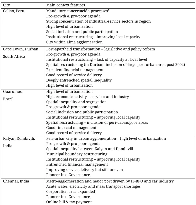
In comparing ICT-GIS-based knowledge across cities we consider the specificities of their historical contexts in order to provide “nuanced, complex, contextual accounts” (Robinson, 2011). Using the relational concept of comparison means that we do not measure our ‘cases’ against a universal yardstick, but “consider both similar and dif-ferent urban outcomes” (Robinson, 2011: 13). Below, the six cities are briefly set in their context (Table 1).
Table 1. City contexts of case study locations
City Main context features
Callao, Peru Mandatory concertación processes8
Pro-growth & pro-poor agenda
Strong concentration of industrial-service sectors in region High level of urbanization
Social inclusion and public participation
Institutional restructuring – improving local capacity City within Lima agglomeration
Cape Town, Durban, South Africa
Post-apartheid transformation – legislative and policy reform Pro-growth & pro-poor agenda
Institutional restructuring – lack of capacity at local level
Spatial restructuring (in Durban- inclusion of large peri-urban area post-2002) Excellent financial management
Good record of service delivery Deeply entrenched spatial inequality High level of urbanization
Guarulhos, Brazil
High level of urbanization
High economic activity – services and industry Spatial inequality and segregation
Pro-growth & pro-poor agenda
Social inclusion and public participation
Institutional restructuring – improving local capacity Spatial restructuring – inclusion of peri-urban/poor areas Good financial management
Good record of service delivery Kalyan Dombivili,
India
Peri-urban city in urban agglomeration – high level of urbanization Pro-growth & pro-poor agenda
Spatial inequality between Kalyan and Dombivili Municipal boundary restructuring
Institutional restructuring – improving local capacity Entrenched financial management
Improving service delivery but still uneven Pioneer in e-Governance
Chennai, India Metro-agglomeration and major port driven by IT-BPO and car industry Acute water, electricity and mass transport shortages
Corporation area expanded Pioneer in e-Governance Online bill & tax payment
The following sections set out the case study results by configuration dimension.
Discourses/rationales for introducing ICT-GIS-based spatial knowledge management
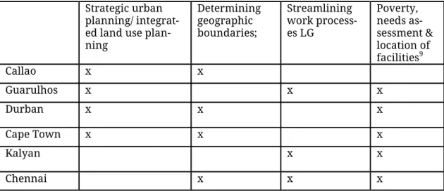
Several discourses were used as rationales for the introduction of ICT-GIS-based KM in local governance, linked to how local governments work in their specific contexts. They relate to four issues:
a) Strategic urban planning and integrated land use planning;
b) Determining geographic boundaries as a pre-condition for more effective planning and urban development discourse;
c) Streamlining work processes of local governments and relations with other levels of government, citizens and the private sector;
d) Poverty/needs assessment, mapping and location of facilities (Table 2).
Table 2. Rationales for introducing ICT-GIS KM systems
X= this rationale was found in the city concerned
Strategic urban planning and integrated land use planning
A first rationale for using ICT-GIS-based KM concerns strategic urban planning and inte-grated land use planning. This was found mainly in the South African and Peruvian cities, in contrast to India where this discourse was largely lacking (Table 2)10.
In South Africa, after the 1994 change of government, a transformative vision was devel-oped of a reduction in the existing spatial segregation and in the inequalities linked to apartheid policies. Now, urban strategic planning by local and provincial governments includes a strong spatial perspective, in which the Spatial Development Framework pro-vides guidance for future urban development (Watson 2002). In Durban and Cape Town,
Strategic urban planning/ integrat-ed land use plan-ning Determining geographic boundaries; Streamlining work process-es LG Poverty, needs as-sessment & location of facilities9 Callao x x Guarulhos x x x Durban x x x Cape Town x x x Kalyan x x Chennai x x x
strategic urban planning utilizes the notion of the ‘compact city’, where high population density facilitates the building of facilities and services, and a spatially defined ‘urban de-velopment line’ limits the area where the full range are provided. In Cape Town, the ‘coastal edge’ added to the recent spatial development framework (SDF, 2012) demar-cates coastal zone areas with environmental risks, and limited future development. Strategic planning in South Africa has also started to include discourses concerning com-petitive, managed cities through the Growth, Employment and Redistribution (GEAR) poli-cy, with a greater market influence on spatial forms. Examples are the “private-sector-driven, up-market, commercial and residential” gated developments such as the aerotrop-olis in Durban and Century City in Cape Town (Harrison et al., 2009: 139).
Integrated land use planning involves processes in which geo-referenced databases from different sources support policy choices (found in Cape Town, Durban, Callao, Guarulhos, and Chennai). In each case, different actors and processes are involved.
In Durban and Cape Town, urban spatial planning was revolutionized in the 1990s by the linking of digital databases and maps, and the provision of fairly up-to-date maps which showed the spatial spread of urban phenomena, and assisted in decision-making.
In Peru the regional government of Callao works on the integration of land use planning together with several municipalities bordering Lima city and including parts of the Lima metropolitan region11. It is a leader in developing ICT-GIS-based KM systems for local governments, and in integrating regional planning based on three knowledge processes; spatial planning, determining boundaries, and specific reports on issues of concern. For spatial planning, documents are prepared collectively by the Callao regional govern-ment, working with line departments of its governgovern-ment, local governments, NGOs and knowledge institutes (MIP) in a concertación process12. Delineating boundaries in a common database was a precondition in making planning feasible and in reducing contestation. Publicly accessible reports on specific topics provide a deeper understand-ing on specific issues and can be used as a basis for decision-makunderstand-ing.
In Guarulhos, Brazil integrated land use planning has been a major municipal concern. They collect, organize, and analyze (spatial) data to inform their urban development poli-cy, which has attracted municipal investments to peri-urban and poorly serviced areas for greater social inclusion. Although Guarulhos is the second largest municipality in the state, it remains a small player in the SP metropolitan region13. Its Development Plan 2004 defined five geographic zones, setting out broad terms for economic development, envi-ronmental protection and social responsibility. A new development plan translates those terms into concrete issues; utilizing improved data production and administrative mod-ernization. The result is that discussions between government departments, professional associations and private sector interests in the city are now based on reliable figures.
Determining municipal boundaries
A second discourse concerns how boundaries for urban development strategies are established when KM is digitized and spatialized. Boundaries (of plots in the city) have to be established more accurately when linking databases to base maps in GIS for city plan-ning.
In South Africa the establishment of physical boundaries is a much-contested process and includes extensive public participation. In Durban the redrawing of municipal adminis-trative boundaries was part of the post-1994 spatial restructuring, and brought marginal areas into larger municipal entities to reduce the effects of spatial segregation (Durban became the eThekwini Municipality). The main idea was that changing municipal bound-aries would facilitate cross-subsidization and smooth out inequalities. The new bounda-ries were integrated into databases and base maps for the planning of urban develop-ments, and the results from the 2002 Census allowed the systematic mapping of existing urban inequalities.
In Peru the precise demarcation of boundaries between municipalities in the constitution-al province of Cconstitution-allao in preparation for the ICT-GIS system was a pre-condition for current spatial planning processes, which are directed towards ecological economic micro-zoning and the spatial management plan. Currently, the provincial government is working with the municipalities to develop background reports for further detailed planning processes linked to major issues in the area.
City boundaries are also redrawn by economic expansion which occurs through or despite city development plans, which exist in all case studies14. However, where eco-nomic growth is fuelled by private developers, city borders are changed as governments come to terms with the new status quo. In Chennai, India where the ‘IT corridor’ south of the city has dominated economic growth, city borders were extended in 2011 by the state government to include large parts of the southern corridor, ensuring that the substantial revenues from the included areas would go to city government.
This discussion shows that digitizing spatial knowledge on boundaries requires more accurate, up-to-date and non-contested information to support urban planning and devel-opment. Whereas SA had the instruments in place at a sophisticated level, these had to be developed in Peru by initiatives at the provincial level, and Brazil and India are still in the process of being developed at local levels15.
Work processes in local government: Administrative efficiency and effectiveness
A third discourse on the introduction of digitized and spatial knowledge concerns improvements in efficiency and effectiveness. This discourse is very strong in India, where the focus of e-governance initiatives has been designed to improve work processes in order to enhance access and delivery of government services to citizens, employees and the managements of urban local bodies, while aiming to strengthen effective governance
and increase transparency (JNNURM, Mandatory primer 1, e-Governance, ULB reform, n.d.). The lack of accurate and up-to-date databases, among other issues, has hampered urban local governments in India from having efficient and effective revenue collections and from being able to monitor developments in their cities; this lack has prevented resi-dents from exercising their citizenship rights effectively and has allowed informal (corrupt) practices to become extensive (Roy 2009). Initiatives for digitization and spatial-izing information within local government have been very uneven in Indian cities; our case study cities Kalyan Dombivili and Chennai were early innovators.
Poverty and needs assessment mapping and locating facilities
Cities have also used digitized and spatialized knowledge to map deprived areas in order to rationalize budget allocations to those urban areas with the most pressing needs; a rationale found in both Durban and Cape Town in South Africa. The Infrastructure Branch of the eThekwini municipality has developed a composite deprivation index to an-alyze the spatial concentration of deprivations, and developed two GIS models as tools for strategic decision-making: the ‘Access to Services’ model and the Cost Surface model16. Both tools provide basic spatial information for decision-making on the location of infra-structure. The models reduce unit costs in promoting a compact city, help determine facil-ity prioritization for informal settlements, and reduce political pressure on location choic-es. This model is now used in decision-making in both cities, and in Cape Town more inte-grated decision-making processes across municipal line functions are being promoted. In India a national programme for urban poverty reduction and slum eradication (RAY), incorporates GIS-based slum mapping in its procedures. The plans are intended to be par-ticipative and involve residents and NGOs/CBOs in guiding community mobilization activ-ities for Slum Surveys, data validation, and slum-level redevelopment/ upgrading models. In practice, slum mapping in pilot projects is currently done by consultant firms. In Chennai slums in five zones were surveyed, but the survey met with resistance from residents, who have little faith in such processes (Sekhar, Hindu, December 15, 2012)17.
Actor networks producing and using knowledge
This section discusses the main actor networks that are building digital and spatial knowledge management configurations. In our case study cities the main actors are gov-ernment departments at different levels, working individually or with hybrid networks (Table 3). They mainly work closely with private sector companies. Cooperation with uni-versities as knowledge institutions is less institutionalized. Urban residents are only rec-ognized as knowledge producers in consultation processes and in feedback processes to local governments.
Table 3. Actor networks in producing ICT-GIS initiatives
In Peru the Callao regional government (Constitutional province) has established a strong regional network with local municipalities, the private sector and NGOs, and works with other actors in exchanging knowledge through online information systems concerned with regional and local issues (concertación process) in an inclusive manner.
In Guarulhos, Brazil local government is spatializing and digitizing information, and has informal links with a university for environmental issues. The national spatial data infra-structure (INDE) sets out the context and the national bureau of statistics (IBGE) provides socio-economic data and map layers for local government to produce GIS-based maps. The City of Cape Town has widened its network by working with the African Centre for Cities (ACC). A series of ‘city labs’ facilitate engagement between academics and city officials. Durban Municipality has recently started working with its University (UKZN) and allows academics to undertake applied research with municipal officials on projects which benefit the city.
In India Kalyan Dombivili was an early innovator in promoting e-governance (1999) and is now a model for other local governments in Maharashtra. Although local govern-ment is the initiator, they work with private sector companies who are very influential in determining the level of expertise implemented by local government.
Local government in Chennai initiated an integrated digitization project with a private company in the late nineties. However, the complexity of the project led to it being scaled down after several years. Recent initiatives to link local government, development author-ities and state government departments in one network to develop integrated ICT-GIS sys-tems were also not successful.
Knowledge exchange and contestation
A basic rationale for digitizing and spatializing knowledge is the opportunity to exchange and coordinate it for more effective local governance. However, the extent of equal access and the contestation of knowledge are issues of concern.
Case study cities Local/ govern-ment levels
Private sector Universities Citizens (NGOs)
Callao x (regional) x x
Guarulhos x x x mainly in
envi-ronment not integrated with municipal Durban
(eThekwini)
x x x (MoU) x
Cape Town x x x(African Centre X
Kalyan Dombivili x x x (technical advice) x (e-grievances)
Chennai x x x (technical univer-
The results showed a lack of knowledge sharing among municipal departments, which limits the possibilities of integrating the mapping of issues for strategic urban planning (e.g. such as is used in Callao and Durban). In Durban data files are held on a central server and are shared by line departments; each department can build on this central database with data relevant to their own function. In Callao a similar regional infrastruc-ture provides information across municipalities. In Guarulhos a joint municipal geo-portal is being developed for limited data exchange between departments. In India the majority of projects are cocooned within their own organization and within a GIS department. In Kalyan Dombivili the lack of information shared between municipal departments means that the opportunity of integrating information on social policy, envi-ronmental issues and revenue collection is lost.
Secondly, results showed that exchanges can be limited and contested when local govern-ments use the private sector as consultants. In Kalyan Dombivili private consultants can analyze the data and prevent such capacity building among municipal staff. In Durban influential GIS consultants are commissioned to analyze spatial data and provide the abil-ity to use knowledge to a greater advantage.
Thirdly, staff in various organizations can undermine the potential transparency of such systems. This particularly applies in situations where KM provides monitoring systems of payments by urban residents, and staff input records of such payments. Existing forms of corruption are threatened by ICT-GIS, and therefore their introduction and correct use is resisted. Audits of e-governance in KD and Chennai have signalled such issues.
Fourthly, there is a limited input of community knowledge. In Durban and Kalyan Dombivili (middle-class) residents provide feedback through digital grievance systems (Martinez et al 2011). In both localities input from poorer communities is limited as it is filtered through councillors who represent communities in participatory processes. That system remains vulnerable to political manipulation. The fifth issue is whether GIS provides valid and reliable knowledge for decision-making. In Durban the Infrastructure Unit promotes GIS as ‘objective’ knowledge which allows facilities to be located and the prioritizing of service provision free from political influence. However, such databases need to be validated. This includes the validity of indicators used, the reliability and accu-racy of data input, and the regular updates of data inputs18.
Conclusions: effects of using spatial knowledge management (SKM) for urban
development
In conclusion we come back to our main question of how knowledge management (KM) within urban governance is being transformed by digitization and spatialization, and its effects on urban development strategies. KM configurations consist of several dimensions: 1) the discourses around digitized KM and types of information/knowledge acknowledged; 2) the networks of actors producing socio-spatial knowledge; 3) the embedding of KM in decision-making processes; and 4) the effects of KM on work practices and outcomes.
The discourses for introducing ICT-GIS based knowledge management were many and varied, including cities, organizations and their mandates. The discourses concerned four issues: strategic urban planning and integrated land use planning; determining geograph-ic boundaries in urban development; streamlining work processes of local governments, and mapping poverty and needs assessments. This suggests that in the South the main rationale for using digitized and spatialized knowledge is focused on gaining firmer con-trol of complex urban development processes, by establishing non-contestable boundaries and expanding urban land use planning databases. This focus is strategic for future economic growth, but also provides possible inputs for prioritization in improving basic services and reducing inequalities. Importantly, knowledge management was geared towards increasing government competences in raising revenues, reducing corrupt work practices, and improving management information systems.
The actors generally recognised as producing knowledge in urban planning and manage-ment are mainly governmanage-ments working with the private sector. Initiatives are national, local and regional. The strongest networks in the development of ICT-GIS initiatives are found between local government and the private sector. However, the technical expertise of the private sector means that their power over local government is strong, and likely to grow, as the ‘smart city’ discourse requires technical expertise outside local government competencies. Links with knowledge institutes and civil society organisations in develop-ing knowledge management are weaker.
The main sectors in which ICT-GIS based knowledge management was introduced con-cern strategic planning, tax assessment and collection, and locating facilities. Some initia-tives for greater interaction with urban residents were found; an increased access to administrative information through websites and through grievance feedback systems. However, these were mainly used by middle-class residents; low-income residents still work through political representatives.
Generally, spatial knowledge platforms and mapping products are strongly dominated by experts using and producing codified and technical information products. This infor-mation is positioned as objective, but is occasionally contested. Several examples of civil society initiatives in building ICT-GIS-based knowledge platforms and databases were found in the city case studies (see Pfeffer et al. 2013). In addition, more deliberative pro-cesses in Lima show that creating ‘spaces’ for more interactive propro-cesses contributes to mutual knowledge building (Miranda Sara, Pfeffer and Baud, 2016). Also the regular inter-action in Durban between citizen initiatives and city experts leads to exchanges of infor-mation and mutual knowledge.
Knowledge exchange remains a difficult issue. Even within government, knowledge does not travel well between departments and different levels of government. Knowledge shar-ing is scarce and in some contexts there is active resistance to the digitizshar-ing of internal da-tabases due to the fear that greater transparency and control will reveal incompetence
and corruption. However, some initiatives are being undertaken in this area. Knowledge exchange and feedback from residents is usually limited and confined to strict guidelines. However, counter-mapping issues elsewhere are opening up through NGOs (e.g. Cheqeado.com in Argentina, Ushahidi in Africa).
The main conclusion is that building ICT-GIS based knowledge management configura-tions is very uneven across cities, sectors and countries. Although a variety of rationales exist for doing so, related to discourses on urban growth, effective urban management, and reducing inequalities, a great deal of effort is still needed to implement digitized and spatialized knowledge management in such a way that it includes a range of knowledge – including from citizens - effectively used in urban planning and management in many cities in emerging economies.
This means that the adaptive capacity of local governments is still limited as they lack the full range of databases over time to support longer-term urban development strategies, and do not yet have interactive processes in place, which would provide more community -embedded knowledge for future decision-making.
References
Baud, I. S. A., & De Wit, J. (2008). New forms of urban governance in India: shifts, models, networks and contestations. Sage.
Baud, I.S.A., Nainan, N. (2008). Negotiated spaces for representation in Mumbai: ward committees, advanced locality management, and the politics of middle-class activism, Environment and urba-nization, 20(2), 483-499.
Baud, I.S.A, K. Pfeffer, J. Sydenstricker & Scott, D. (2011). Developing Participatory 'Spatial' Know-ledge models in metropolitan governance networks for sustainable development. Literature Re-view, March, Working Paper EU programme Chance2Sustain, EADI.
I.S.A. Baud, N. Sridharan and K. Pfeffer (2008). Mapping urban poverty for local governance in an Indian mega-city; the case of Delhi: in Urban Studies, June: 45: 1385-1412.
Brenner, Neil. 2004. New State Spaces: Urban Governance and the Rescaling of Statehood. Oxford University Press.
Campbell, T. (2012). Beyond Smart Cities; how cities network, learn and innovate, Earthscan, Lon-don.
City of Cape Town. 2012. City of Cape Town coastal set-back delineation: method and process. 2012.
Cornwall, A. & Gaventa, J. (2001). From users to choosers to makers and shapers: repositioning participation in social policy, IDS Working Paper 127, Brighton, Sussex.
Davis, M. (2006). Planet of Slums, Verso.
Gaventa, J. (2006). Triumph, Deficit or Contestation? Deepening the ‘Deepening Democracy’ Deba-te, IDS Working paper 264. Brighton, Sussex.
Georgiadou, Y., and Stoter, J. (2010). “Studying the Use of Geo-Information in Government – A Con-ceptual Framework.” Computers, Environment and Urban Systems 34 (1): 70–78. doi:10.1016/ j.compenvurbsys.2009.04.002.
Giezen, M. (2012). Navigating mega projects through complexity and uncertainty: strategic and adaptive capacity in planning and decision-making, PhD Dissertation, University of Amsterdam
Harrison, P, Todes, A and Watson, V. (2009). Planning and Transformation: Learning from the Post -Apartheid Experience, Abingdon, UK, Routledge.
Harvey, F., & Tulloch, D. (2006). Local‐government data sharing: Evaluating the foundations of spatial data infrastructures. International Journal of Geographical Information Science, 20(7), 743 –768.
Healey, P. (2007). Urban complexity and Spatial Strategies: Towards a Relational Planning for our Times, London, Routledge.
Heller, P. (2009). Democratic Deepening in Brazil, India and South Africa: Towards a Comparative Framework, Paper prepared for “Building Sustainable Democracies” Indiana University, Bloo-mington January 29-30.
Hordijk M.A & Baud, I.S.A. (2011). Inclusive Adaptation: Linking Participatory Learning and know-ledge management to urban resilience, in Zimmermann K.O. (Ed) Resilient Cities, Cities and Adap-tation to Climate Change, Proceedings of the Global Forum 2010, Springer Verlag, Dordrecht, 111-121
JNNURM, Mandatory primer 1, e-Governance, ULB reform, n.d.; p.2. Accessed from: http:// www.indiaurbanportal.in/reforms/local/e-governance.pdf
Kahila, M. and M. Kyttä (2009) SoftGIS as a Bridge-Builder in Collaborative Urban Planning, in: S. Geertman, J.C.H. Stillwell (eds.), Planning Support Systems Best Practice and New Methods, 389 – 411.
Kennedy, L. et al. (2011). The Politics of Large-Scale Economic and Infrastructure Projects in Fast-Growing Cities of the South, Literature Review, Chance2Sustain, EADI.
Kitchin, R., J. Gleeson & Dodge, M. (2013). Unfolding mapping practices: a new epistemology for cartography, Transactions of the Institute of British Geographers, 38, 480–496.
Martinez, J. (2009). The use of GIS and indicators to monitor intra-urban inequalities: A case study in Rosario, Argentina, Habitat International, 33, 387–396.
Martinez, J., Pfeffer, K. & van Dijk, T. (2011) E-government tools, claimed potentials, unnamed limi-tations, Environment and Urbanization Asia, 2(2), 223-234.
McCall, M.K. & Dunn, C.E. (2012). Geo-information tools for participatory spatial planning: Ful-filling the criteria for ‘good’ governance?, Geoforum, 43(1), 81-94.
McCall, M.K., Martínez, J.A. and Verplanke, J.J. (2014) Shifting boundaries of volunteered geo-graphic information systems and modalities: learning from PGIS. In: ACME : an international e - journal for critical geographies : open access, (2014) IN PRESS 36 p.
McCann, E. & Ward, K. (2011). Mobile Urbanism, University of Minnesota Press, Minneapolis. McFarlane, C. (2011). Learning the City, Knowledge and Translocal assemblage, Wiley-Blackwell, Sussex.
McFarlane, C. (2011). Learning the City, Knowledge and Translocal Assemblage. Wiley-Blackwell. Sussex.
McFarlane, C. (2008). Sanitation in Mumbai’s informal settlements: state, ‘slum’ and infrastructu-re. Environment and Planning A, 40(1), 88–107.
Ministry of Urban Development (2010) Handbook on Service level Benchmarks for E-governance in Municipalities. Ministry of Urban Development, New Delhi.
Miranda Sara, L., Pfeffer, K., Baud, I.S.A. (2016,) Unfolding Urban Geographies of Water-Related Vulnerability and Inequalities; Recognising Risks in Knowledge Building in Lima, Peru. In: Allen, A. Bell, S., Hofmann, P., The, H-E. (eds.) Urban Water Trajectories. Routledge, London.
Monmonnier, M. (1991). How to Lie with Maps, University of Chicago Press, Chicago.
Peyroux, E., Scott, D., Baud, I.S.A., Jameson, S. (2014). Spatial Knowledge Management and Partici-patory Governance: Rethinking the Trajectories of Urban, Socio-Economic and Environmental Change and the Politics of ‘Sustainability’ in Southern cities. C2S Report.
Pfeffer, K., Martinez, J., O’Sullivan, D., Scott, D. (2015) Geo-technologies for Spatial knowledge: challenges for Incusive and Sustainable Urban Development, in: Gupta, J., Pfeffer, K., Verrest, H., Ros-Tonen, M. (eds.) Geographies of Urban Governance: Advanced theories, methods, and practi-ces. Springer.
Pfeffer, K., Baud, I.S.A., Denis, E., Scott, D. & Sydenstricker-Neto, J. (2013). ‘Participatory spatial knowledge management tools’, Information, Communication & Society, 16 (2), 258–285.
Pfeffer, K., Deurloo, M.C. and Veldhuizen, E.M. (2012) Visualising postcode data for urban analysis and planning: the Amsterdam City Monitor. Area, 44(3), 326-335.
Pfeffer, K., J. Martinez, I.S.A. Baud, N. Sridharan. (2011). Knowledge production in Urban Gover-nance Systems through Qualitative Geographic information systems (GIS), Environment and Urba-nization ASIA, 2(2), 235-250.
Prins, J. E. J., Broeders, D., & Griffioen, H. M. (2012). iGovernment: A new perspective on the future of government digitisation. Computer Law & Security Review, 28(3), 273–282.
Richter, C. (2014). Digital transformations in Indian cities: Between paper list and GIS map (PhD. Dissertation). University of Twente, Enschede, The Netherlands.
Robinson, J. (2011). Cities in a World of Cities: The Comparative Gesture. International Journal of Urban Regional Research, 35 (1), 1-23.
Robinson, J. (2006). Ordinary cities: between modernity and development, Vol. 4. London: Routled-ge.
Roy, A. (2009) Civic Governmentality: The Politics of Inclusion in Beirut and Mumbai, Antipode, 41 (1), 159-179.
Scott, D., & Barnett, C. (2009). Something in the Air: Civic science and contentious environmental politics in post-apartheid South Africa. Geoforum, 40(3), 373–382.
Sekhar, S. (December 15, 2012) “By March, slum survey in city to be complete”, The Hindhu, http:// www.thehindu.com/news/cities/chennai/by-march-slum-survey-in-city-to-be-complete/ article4200675.ece, Accessed December 13, 2013.
Shatkin, G. (2007). Global cities of the South: Emerging perspectives on growth and inequality, Cities, 24 (1), 1–15.
Van Ewijk, E. & Baud, I.S.A. (2009). Partnerships between Dutch municipalities and municipalities in countries of migration to the Netherlands: knowledge exchange and mutuality, Habitat Interna-tional, 33(2), 218-226.
Watson V (2002): Change and Continuity in Spatial Planning: metropolitan planning in Cape Town under political transition. Routledge, London and New York.
Wood, D. (2012). Rethinking the power of Maps, Guilford Press, NY, London.
Wright, G., Pranesh P., Abraham, S. & Shah, N. (2010). Open Government Data Study: India, The Centre for Internet and Society.
Notes
1
This article is a shortened and adapted version of the Baud et al. article in Habitat International 2014, entitled “Digital and spatial knowled-ge manaknowled-gement in urban governance: Emerging issues in India, Brazil, South Africa, and Peru”.
2
Major questions within this debate are whether the digitization and spatialization of information and knowledge empower citizens (transparency and accountability) or whether such tools increase levels of surveillance (Prins, Broeders and Griffioen 2012).
3
For a definition of tacit, codified and contextual-embedded knowledge, please refer to van Ewijk and Baud (2009) and the literature review of WP5 (Baud et al. 2011).
4
“About 60% of the Indian population have mobile phones, but there are only about 2 million active users of mobile Internet services – less than 0.1% of the population.” (Wright et al., 2010: 8).
5
The introduction of ICT-GIS-based KM systems influences work processes and interfaces with citizens in planning processes, administrative processes, interactive processes which provide feedback from citizens, and in the CSO-based construction of community knowledge (cf. Pfeffer et al. 2012).
6
We gratefully acknowledge the funding provided by the EU 7th Framework Programme. under project no. 244828). Project Partners in this project are the European Association of Development Research and Training Germany; Amsterdam Institute of Social Science Research Uni-versity of Amsterdam (The Netherlands); French National Center for Scientific Research (CNRS) France; School of Planning and Architecture (SPA) India; Cities for Life Forum (FORO) Peru; Centro Brasileiro de Análise e Planejamento (CEBRAP) Brazil; Norwegian Institute for Urban and Regional Research (NIBR), Norway and the University of KwaZulu-Natal (UKZN) South Africa. For more information, see: http:// www.chance2sustain.eu/
7 In addition, post-graduate students carried out 2-3 months fieldwork concerned with similar topics in the various cities. 8
Concertación is the process in which stakeholders work together toward final outcomes.
9 In Peru this is done at the national level and provided to local governments.
10 In Chennai the Development Authorities have their own GIS section, which provides maps for the Master Plan.
11 This area is strategic in terms of economic activities (harbour, airport, industry), as well as environmentally important (coastal zone), with
higher levels of immigration than elsewhere.
12
They include the report on delineating and determining territorial boundaries in the Constitutional province of Callao, zoning for spatial demarcation, the organization of the district of Ventanilla, and reports on human settlements (Mercedes Mi Peru, Porcino Park project, a report on all settlements in Callao, and one on hazards in human settlements in Callao province).
13
This is the result of the size of the city of Sao Paulo itself, as well as of the institutional challenges to the orchestration of action plans by a metropolitan body.
14
In Kalyan Dombivili the CDP of 2011; in Chennai the 2009 CDP Review; in Guarulhos the Macro-zoning plan of 2004; in Durban the Spatial development Frameworks in 2002, 2008 and 2011; in Cape Town the SDF of 2012.
15
In India in particular the establishment of land boundaries is an ongoing process with high levels of contestation (Collabland, p.c. NIT-Chennai 2013).
16
The ‘Access to Services’ model models the supply of and demand for social facilities across the Metropolitan area and is able to predict the future social services requirements for housing. The ‘Cost Surface’ Model predicts the cost of servicing any piece of land in the city.
17
This programme was discontinued by the new Modi government in 2014, and was replaced by the Smart Cities programme.
18
In India eligibility for food subsidies is determined by households’ ‘below the poverty line (bpl)’ status, determined both by political access as well as income levels. Databases on bpl households therefore reflect a set of mixed criteria, making them invalid for poverty mapping.