HAL Id: hal-01795303
https://hal.univ-lorraine.fr/hal-01795303
Submitted on 18 May 2018HAL is a multi-disciplinary open access archive for the deposit and dissemination of sci-entific research documents, whether they are pub-lished or not. The documents may come from teaching and research institutions in France or abroad, or from public or private research centers.
L’archive ouverte pluridisciplinaire HAL, est destinée au dépôt et à la diffusion de documents scientifiques de niveau recherche, publiés ou non, émanant des établissements d’enseignement et de recherche français ou étrangers, des laboratoires publics ou privés.
modelling
Guillaume Caumon, Jean-Laurent Mallet
To cite this version:
Guillaume Caumon, Jean-Laurent Mallet. 3D Stratigraphic models: representation and stochastic modelling. IAMG 2006, Int. Assoc. for Mathematical Geology XIth International Congress, 2006, Liège, Belgium. �hal-01795303�
Université de Liège - Belgium
3D Stratigraphic models: representation and stochastic modelling
G. Caumon1, J.L. Mallet1
1
CRPG-CNRS / Nancy Université, Nancy France
Corresponding author: [email protected]
ABSTRACT: Several representations have been proposed to model the 3D architecture and petrophysical properties of stratigraphic formations from subsurface data. All methods aim at finding a consistent way of describing heterogeneities by defining a curvilinear coordinate system conform to the sedimentary layers. Classically, this coordinate system is implicitly defined by a grid conforming to the strata and to the faults; alternatively, the Geo-chronological model (Geochron) explicitly defines this coordinate system, without using such a grid. This paper compares the grid-based stratigraphic modeling methods with the Geochron method. Their ability to represent complex fault networks is discussed, proving the higher representative power of the Geochron model. Because the visualization of uncertainty calls for generating several possible images of the subsurface, we also discuss grid perturbation methods, and introduce a new method to stochastically perturb a Geochron model.
KEYWORDS: Stratigraphic modeling; uncertainty; time-stratigraphy; inverse modeling.
1.
Stratigraphic representations
The goal of a 3D geological model is to describe the geometry and petrophysical properties of the subsurface in a consistent manner with observation data. Stratigraphic formations, which host most of the world’s hydrocarbon reserves, call for specific 3D modeling techniques. Such methods are not equivalent, since they may introduce model simplifications, especially in domains affected by faults.
1.1. Vertical scaling
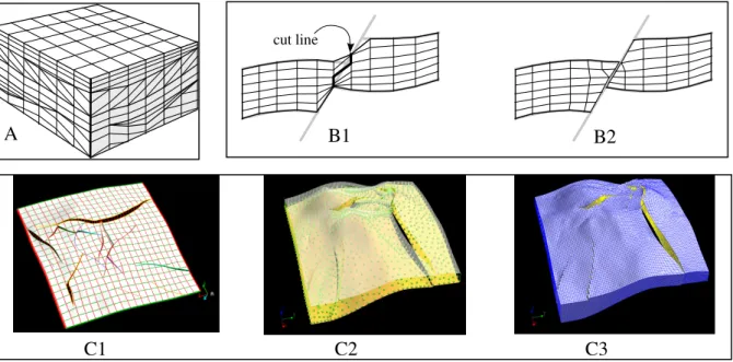
Pioneering stratigraphic representations are based on vertical scaling. For instance, Johnson and Jones (1988) use a 3D Cartesian Grid to represent formations, but rescale the z coordinate to examine correlations between wells. This model is then upscaled to a coarse corner-point geometry flow simulation grid. Swanson (1988) directly creates a curvilinear simulation grid with constant cell area but with variable thickness (Fig. 1-A). The grid is aligned on sequence boundaries, and the layering inside sequences can mimic typical stratigraphic styles (Fig. 1-A). Vertical scaling can be applied only to non-faulted formations, and cannot handle overturned structures.
1.2. Stratigraphic gridding
Corner-point stratigraphic grids, in which grid blocks have an irregular geometry, can conform to strata, faults, or meandering channels (Shtuka et al, 1996; Chambers et al, 1999). These grids are suited to the representation of complex geological structures, provided that there is no constraint on the shape of their cells. Unfortunately, flow simulation using finite differences techniques calls for homogeneous cell sizes and sub-orthogonal cell corners. Therefore, a compromise must be found between geological accuracy and grid quality. For this, the choice of a grid construction method is paramount. Bennis et al (1996) proceed fault block by fault block, which is not practical for a large number of faults, and assumes that fault blocks have the same topology as a cube. Instead, the grid can be warped to honor horizons, and then cut by the fault network and interpolated (DeBaun et al, 1996; Fig. 1-B). This approach generates ill-shaped cells around faults, so an alternative is to compute a
Université de Liège - Belgium
quadrangulated mesh on a horizon (2D parameterization), then extrude this mesh to the whole volume (Bombarde et al, 1996; Fig. 1-C) along extrusion lines (also called fibers or pillars). Curvilinear fibers (Cognot et al. 2001; Fremming, 2002) can be aligned on the fault network for more accuracy. None of these approaches easily accounts for pseudo-horizontal fault contacts between a synthetic an antithetic fault (Y, X or λ contacts). Attempts have been made to address this difficult problem, for instance by combining two 3D parameterizations (Cognot et al. 2001). Geological accuracy is then possible, but the resulting grid cell geometry is not acceptable for flow simulation. Therefore, most current approaches first create a grid conform to the synthetic faults, and then use cut-based methods to generate stair-stepped antithetic faults.
Fig. 1. Stratigraphic gridding approaches. A: Vertical scaling according to sedimentary styles (from Swanson, 1988); B: Global grid warping followed by an interpolation; C: extrusion of a
parameterized triangulated surface. 1.3. Geo-chronological space
In structurally complex areas, the construction of a stratigraphic grid is extremely difficult and tedious to achieve, if only possible. The limited 3D grid resolution and the pseudo-orthogonality between cell faces required by flow simulators necessarily introduce simplifications and violations of common geological sense (faults networks are not made of orthogonal and evenly spaced faults). Therefore, while faults have a tremendous impact on subsurface heterogeneities, their geometry and slip are often coarsely approximated in stratigraphic grids, independently of the construction method.
The problem of modeling faulted stratigraphic formations and that of generating reservoir grids need not be considered simultaneously: generating first a model of stratigraphic architecture and petrophysical properties can actually be done before thinking about the generation of a volumetric mesh. This idea is central to the concept of Geochronological Space (Geochron) proposed by Mallet (2004): for any point x inside a 3D geological model, the goal is to define three spatial functions u(x), v(x), t(x). u(x) and v(x) correspond to the paleo-geographic coordinates of point x at deposition time, before any tectonic deformation.
t(x) corresponds to the geological time at which the point x was deposited. The parameter t is constant along isochronous sedimentary surfaces such as maximum flooding surfaces.
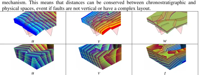
The Geochron model is a 3D mathematical formulation of 2D Wheeler diagrams used in sedimentology (Wheeler, 1958). Geochron is also a generalization over previous stratigraphic modeling approaches, since the areal gridding of a stratigraphic grid implicitly defines a (u, v) coordinate system on horizons (Fig. 2). However, in Geochron, the gradient of the t
cut line
A B1 B2
C3 C2
Université de Liège - Belgium
coordinate is not assumed to be vertical or aligned on the fault network (Fig. 2), as is the case for the layer stacking direction in stratigraphic grids. In the Geochron model, the stacking of layers can be orthogonal to stratigraphic horizons or conform to a flexural slip deformation mechanism. This means that distances can be conserved between chronostratigraphic and physical spaces, event if faults are not vertical or have a complex layout.
u v w
u v t
Fig. 2. Curvilinear stratigraphic coordinates in a stratigraphic grid (first line) and in a Geochron model (second line). Whereas (u, v, w) coordinates are aligned on the grid mesh, hence on some faults,
(u, v, t) can be discontinuous across faults in the Geochron model, for a better accuracy.
The Geochron model can be created by interpolating the (u, v, t) coordinates on a tetrahedral mesh (Moyen, 2005). Geostatistical algorithms can be applied in (u, v, t) coordinates to populate the stratigraphic volume with properties. If needed, the physical space can be meshed, e.g. using techniques described by Prevost et al (2005).
2.
Stratigraphic uncertainty modeling
2.1. Stratigraphic uncertainty modelingGeostatistical simulation generates stochastically hundreds of petrophysical property models both on stratigraphic grids and in the Geochron framework. However, quantitative assessment of structural uncertainty is essential.
Methods have been developed to perturb the geometry of stratigraphic grids, using autocorrelated random perturbations of the grid geometry (Thore et al, 2002). Depth and thickness variations typically affect the entire grid by moving cell corners in the vertical (or the w grid axis) direction to account for horizon uncertainty (Corre et al., 2000). Modeling of the uncertainty about fault positions is more difficult and may require a full grid reconstruction (Thore et al., 2002; Lecour et al., 2001). Instead, free-form deformation techniques such as Simple Constrained Deformation (Borrel and Rappoport, 1994) can be applied to account for fault perturbations in an existing grid (Zhang and Caumon, 2006). This approach is appropriate in reasonably complex models for small uncertainties, but cannot replace a full grid generation when structural uncertainty is very large.
Methods to assess geometric uncertainty have not yet been described for the Geochron model. The implicit representation of horizons used by Moyen (2005)’s implementation is suited to an easy randomization of the position and thickness of strata: the t coordinate, available at every point in the reference model, can be incremented by some stochastic, spatially correlated scalar field computed either in GeoChron space or on the tetrahedral mesh. Uncertainty about the faults is, in the case of Geochron also, more difficult to model. When only small fault perturbations are needed to represent the geometrical uncertainty about faults, then the model updating methods described by Tertois (2006) are adapted. When the structural uncertainty is larger, reliable methods must be defined to update locally a Geochron model while allowing for topological changes. This calls for adapting and improving existing methods for volume model updating (Caumon et al., 2004) to Geochron models.
Université de Liège - Belgium
3.
Future work
Stratigraphic modeling still raises a number of challenges. The Geochron model does not presently address gridding, which is required for simulation of physical processes. The work of Prevost et al (2005) must be pursued. Also, in all stratigraphic models, the scale and volume support would require more consideration, especially since the application of geostatistical methods assume that volumes are conserved between the physical and the chronostratigraphic spaces, which is not necessarily true.
Acknowledgments: The authors would like to thank all members of the Gocad Consortium for their support, and especially EarthDecision for providing the Gocad software. We also want to thank Richard Cognot, Laurent Deny Bruno Lévy and Rémi Moyen for their involvement in this research.
REFERENCES
C. Bennis, W. Sassi, J.-L. Faure, and F. Hage Chehade. One more step in gocad stratigraphic grid generation, 1996. Taking into account faults and pinchouts. In Proc. European 3D Reservoir
Modelling Conference (SPE 35526).
S. Bombarde, 1997. Building stratigraphic surfaces tied to well markers using a morphing-like approach - application to stratigraphic grid building. In Proc. 15th Gocad Meeting, Nancy.
P. Borrel and A. Rappoport, 1994. Simple Constrained Deformations for Geometric Modeling and DesignACM Transactions on Graphics, 13(2):137-155, 1994.
G. Caumon, F. Lepage, C Sword and J.-L. Mallet, 2004. Building and Editing a Sealed Geological Model. Mathematical Geology, 36(4): 405-424.
K. T. Chambers, D. R. DeBaun, L. J. Durlofsky, I. J. Taggart, A. Bernath, A.Y. Shen, H. A. Legarre, D. J. Goggin (1999). Geologic Modeling, Upscaling and Simulation of Faulted Reservoirs Using Faulted Stratigraphic Grids. In Proc. SPE Reservoir Simulation Symposium (SPE 51889), Houston. R. Cognot, J.-L. Mallet, L. Souche, J. Massot, and L. Deny, 2001. Fiber based sgrid construction. In
Proc. 21st Gocad Meeting, Nancy, France.
B. Corre, P. Thore, V. de Feraudy, and G. Vincent, 2000. Integrated uncertainty assessment for project evaluation and risk analysis. In Proc. SPE ATCE (SPE 65205).
N. Fremming, 2002. 3d geological model construction using a 3d grid. In Proc. ECMOR VIII. 7p. C. Johnson and T. Jones, 1988. Putting geology into reservoir simulations: a three-dimensional modeling approach. In Proc. SPE ATCE (SPE 18321). 10 p.
J.-L. Mallet, 2004. Space-time mathematical framework for sedimentary geology. Mathematical
geology, 36(1):1-32.
R. Moyen, 2005. Paramétrisation 3D de l'espace en Géologie sédimentaire : Le modèle Geochron.
PhD. Thesis, INPL, France.
M. Prévost, F. Lepage, L. Durlofsky, and J.-L. Mallet, 2005. Unstructured 3d gridding and upscaling for coarse modelling of geometrically complex reservoirs. Petroleum Geoscience, 11(4):339-345. A. Shtuka, P. Samson, and J.-L. Mallet, 1996. Petrophysical simulation within an object-based reservoir model. In Proc. European 3D Reservoir Modelling Conference (SPE 35480).
D. Swanson, 1988. A new geological volume computer modeling system for reservoir desciption. In
Proc. SPE ATCE (SPE 17579), pages 293-302.
A.-L. Tertois and J.-L. Mallet, 2006. Preserving Geological Information during Real-Time Editing of Faults in Tetrahedral Models. In Proc. IAMG’2006, Liège.
P. Thore, A. Shtuka, M. Lecour, T. Ait-Ettajer, and R. Cognot, 2002. Structural uncertainties: determination, management and applications. Geophysics, 67(3):840-852.
H. F. Wheeler, 1958. Time-stratigraphy. Bull. of the AAPG, 42(5):1047-1063.
L. Zhang and G. Caumon, 2006. Perturbation of fault network geometry on a stratigraphic grid. Proc.