HAL Id: insu-00979593
https://hal-insu.archives-ouvertes.fr/insu-00979593
Submitted on 16 Jul 2014
HAL is a multi-disciplinary open access
archive for the deposit and dissemination of
sci-entific research documents, whether they are
pub-lished or not. The documents may come from
teaching and research institutions in France or
abroad, or from public or private research centers.
L’archive ouverte pluridisciplinaire HAL, est
destinée au dépôt et à la diffusion de documents
scientifiques de niveau recherche, publiés ou non,
émanant des établissements d’enseignement et de
recherche français ou étrangers, des laboratoires
publics ou privés.
Tectonic and paleogeographic implications
Roderic Bosboom, Guillaume Dupont-Nivet, Wentao Huang, Wei Yang,
Zhaojie Guo
To cite this version:
Roderic Bosboom, Guillaume Dupont-Nivet, Wentao Huang, Wei Yang, Zhaojie Guo. Oligocene
clock-wise rotations along the eastern Pamir: Tectonic and paleogeographic implications. Tectonics,
Amer-ican Geophysical Union (AGU), 2014, 33 (2), pp.53-66. �10.1002/2013TC003388�. �insu-00979593�
Oligocene clockwise rotations along the eastern
Pamir: Tectonic and paleogeographic implications
Roderic Bosboom1, Guillaume Dupont-Nivet1,2,3, Wentao Huang1,2, Wei Yang2,3, and ZhaoJie Guo2 1
Paleomagnetic Laboratory Fort Hoofddijk, Faculty of Geosciences, Utrecht University, Utrecht, Netherlands,2Key Laboratory of Orogenic Belts and Crustal Evolution, Ministry of Education, Peking University, Beijing, China,3Géosciences
Rennes, UMR-CNRS 6118, Université de Rennes1, Rennes Cedex, France
Abstract
Despite the importance of the Pamir range in controlling Asian paleoenvironments and land-sea paleogeography, its tectonic evolution remains poorly constrained in time and space, hindering its potential for understanding deep to surface processes. We provide here new constraints on vertical-axis tectonic rotations from the southwest Tarim Basin along the easternflank of the Pamir arcuate range based on paleomagnetic results. Two well-dated Eocene to Oligocene sections, previously analyzed using biostratigraphy and magnetostratigraphy, yield consistently clockwise rotations of 21.6 ± 4.2° in 41 to 36 Ma strata then 17.1 ± 6.5° in 33 to 28 Ma strata at the Aertashi section and 14.2 ± 11.5° in 41 to 40 Ma strata at the Kezi section. Combined with a regional review of existing paleomagnetic studies, these results indicate that most of the clockwise rotations along the eastern Pamir occurred during Oligocene times and did not extend systematically and regionally into the Tarim Basin. In contrast, on the westernflank of the Pamir tectonic rotations in Cretaceous to Neogene strata are regionally extensive and systematically counterclockwise throughout the Afghan-Tajik Basin. This timing and pattern of rotations is consistent with paleogeographic reconstructions of the regional sea retreat out of Central Asia and supports a two-stage kinematic model: (1) symmetric rotations of either flanks of the Pamir arcuate range until Oligocene times followed by (2) continued rotations on its western flank associated with radial thrusting and, along the easternflank, no further rotations due to decoupled transfer slip starting in the Early Miocene.1. Introduction
The arcuate Pamir range (Figure 1) formed during the northward indentation of India into Asia, constituting a prominent tectonic feature and a major paleogeographical divide with important implications on Asian paleoclimate evolution [Bershaw et al., 2012; Burtman and Molnar, 1993]. It closed the Tarim Basin to the east from the Afghan-Tajik and Ferghana Basins to the west and partly forced the retreat of an epicontinental sea that formerly extended across Eurasia [Bosboom et al., 2014; Bosboom et al., 2011; Bosboom, 2013]. Lithospheric structures below the Pamir inferred from teleseismic and tomographic studies [Negredo et al., 2007; Sippl et al., 2013] suggest a complex history of slab break off, continental subduction inversion, and roll back [e.g., Sobel et al., 2013]. Despite the importance of this range and its potential for understanding deep to surface pro-cesses, its tectonic evolution remains poorly constrained in time and space. The general consensus is that the Pamir indented northward ~300 km into the Eurasian continent [e.g., Burtman and Molnar, 1993; Cowgill, 2010], starting in Early Eocene times as a relatively straight east-west range aligned with the West Kunlun Shan and ending as the highly curved concave southward range observed today. The acquisition of this peculiar geometry has been proposed to be related either to oroclinal bending or radial thrusting associated with regionally extensive vertical-axis rotations [Bazhenov and Burtman, 1986; Bazhenov et al., 1994; Robinson et al., 2004; Strecker et al., 1995] or to transfer faulting induced by opposite shear along the eastern (sinistral) and western (dextral) margins of the Pamir with limited to no vertical-axis rotations [Burtman and Molnar, 1993; Searle, 1996]. Paleomagnetism provides an opportunity to differentiate between these proposed kinematic models by its ability to quantify and date vertical-axis rotations of crustal fragments with respect to a stable continent [Butler, 1992]. Paleomagnetic studies in the Afghan-Tajik Basin on the west side of the Pamir have revealed regionally consistent counterclockwise vertical-axis rotations [Bazhenov and Mikolaichuck, 2002; Bazhenov et al., 1994; Burtman, 2000; Pozzi and Feinberg, 1991; Thomas et al., 1993, 1994]. However, along its eastern flank in the Tarim Basin, West Kunlun Shan, Altyn Tagh, and Tian Shan various rotation studies show large discrepancies in both sense and magnitude of rotation [e.g., Chen et al., 1992; Gilder et al., 1996; Li et al., 2013;
Tectonics
RESEARCH ARTICLE
10.1002/2013TC003388
Key Points:
• Paleomagnetic study reveals Oligocene clockwise rotation along eastern Pamir
• Until Miocene Pamir developed sym-metrically by radial thrusting • From Miocene asymsmetric
deforma-tion with transfer faulting along eastern Pamir Correspondence to: R. Bosboom, [email protected] Citation: Bosboom, R., G. Dupont-Nivet, W. Huang, W. Yang, and Z. J. Guo (2014), Oligocene clockwise rotations along the eastern Pamir: Tectonic and paleogeo-graphic implications, Tectonics, 33, 53–66, doi:10.1002/2013TC003388. Received 6 JUN 2013
Accepted 30 DEC 2013
Accepted article online 5 JAN 2014 Published online 15 FEB 2014
Rumelhart et al., 1999; Wei et al., 2013; Yin et al., 2000], hindering understanding of the kinematics underlying the tectonic evolution of the Pamir.
Here we provide new constraints on the vertical-axis tectonic rotation along the easternflank of the Pamir (Figure 1), based on paleomagnetic results from two well-dated Eocene to Oligocene sections previously ana-lyzed using bio- and magnetostratigraphy [Bosboom et al., 2013]. We combine our results with a regional review of existing paleomagnetic results to constrain the timing, the sense, the magnitude, and the regional distribu-tion of tectonic deformadistribu-tion and ultimately evaluate the tectonic and paleogeographic evoludistribu-tion of the Pamir.
Kabul b lock Paropamisus 70°E 75°E 35°N 38°N 80°E Alai valley 76° 50' 76° 00' 77° 00'
Figure 1. Simplified tectonic map of the Pamir collision zone (modified from Cowgill [2010]) showing the calculated rotations
and their uncertainties with respect to the Eurasian apparent polar wander path (APWP) at the studied sections of Aertashi (AT) and Kezi (KZ) along the (a) eastern Pamir. (b) The inset shows the regional location of the Tarim Basin (present-day coastal
outline obtained from GPlates 0.9.7.1). (c) The detailed geological map of thefield area shows the lithostratigraphic units,
tectonic features, and locations of the Aertashi (AT) and Kezi (KZ) sections along the eastern margin of the Pamir (modified
2. Geological Setting
The Tarim Basin is a relatively undeformed crustal block within the Indo-Asia collision system [Yin and Harrison, 2000]. Thrusting and exhumation around the Pamir range is expressed by the Main Pamir Thrust bounding the Alai Valley to the north, the dextral Kashgar-Yecheng transfer system (KYTS) bounding the Tarim Basin on the eastern flank, and the sinistral Darvaz-Karakul strike-slip fault bounding the Afghan-Tajik Basin on the western flank (Figure 1). According to sedimentologic [Burtman, 2000; Yin et al., 2002], stable isotope and provenance [Bershaw et al., 2012], thermochronologic [Amidon and Hynek, 2010; Sobel and Dumitru, 1997], paleomagnetic [Thomas et al., 1994; Yin et al., 2002], and backstripping [Yang and Liu, 2002] data, these bounding structures are generally thought to have been active mostly into Miocene times with sparse evidence for earlier Eocene initiation. The sedimentary infill on top of the crustal basement is primarily composed of Paleozoic and Mesozoic clastic sediments, recording the successive distal accretion of continental terranes along the southern margin of Asia from the Late Triassic until the Eocene Indo-Asia collision at ~50 Ma [Hendrix et al., 1992; Jia et al., 2004; Robinson et al., 2003; Tian et al., 1989; van Hinsbergen et al., 2012; Yin and Harrison, 2000]. Distal marginal overthrusting and tectonic loading of the paleo-Tian Shan in the north and the paleo-Pamir-Kunlun orogenic system in the south by the Cenozoic northward movement of India into Eurasia probably initiated two major distal foreland basins, the Kuche depression along the southern margin of the Tian Shan and the southwest depression along the eastern Pamir with its depocenter near Yarkand (Figure 1) [Burtman and Molnar, 1993; Cowgill, 2010; Jia et al., 1997; Yang and Liu, 2002; Yin and Harrison, 2000]. The progressive and long-term retreat of a shallow sea covering most of the Tarim Basin in the Early Eocene [Burtman, 2000; Burtman et al., 1996; Lan and Wei, 1995; Tang et al., 1989] has been related to distal tectonic deformation [e.g., Bosboom et al., 2013; Wei et al., 2013]. The sea retreated out of the paleodepocenter in the southwest depression in the middle Eocene [Bosboom et al., 2011; Bosboom et al., 2013] and out of the westernmost Tarim Basin in the Late Eocene [Bosboom, 2013]. Thereafter, continental deposition was predominant with relatively distal environments and remnant brackish-marine conditions up into the Oligocene [Ye et al., 1996; Gao et al., 2000; Graham et al., 2005; Jia et al., 2004; Kent-Corson et al., 2009; Ritts et al., 2008; Zheng et al., 1999], followed by the Early Miocene initiation of rapid accumulation of coarse-grained clastics in proximal alluvial environments throughout the region [e.g., Bershaw et al., 2012; Charreau et al., 2005; Heermance et al., 2007; Huang et al., 2006; Jia et al., 2004; Sobel and Dumitru, 1997; Sobel et al., 2006; Thomas et al., 1993, 1994].
The studied sedimentary sections are located along the eastern Pamir (Figure 1) within the western margin of the Tarim Basin, separated from the Pamir by the dextral Kashgar-Yecheng transfer system (KYTS) [Cowgill, 2010; Sobel et al., 2011]. According to local structural work of Yin et al. [2002], the structural style of the studied area is apparently dominated by recent thrusting and dextral slip associated to the Kashgar-Yecheng transfer system (KYTS) and younger deformation.
3. Paleomagnetic Analyses
In order to quantify vertical-axis rotations, we present here the directional analysis of magnetostratigraphic results previously acquired from marine and continental sediments in the southwest Tarim Basin at the Aertashi (37°58′N, 76°33′E) and Kezi (38°26′N, 76°24′E) sections (Figure 1) [Bosboom et al., 2013]. Bosboom et al. [2013] showed using rock and thermomagnetic analyses that the marine sediments of the Kashi Group at both sections all yielded normal polarity in the present-dayfield direction before bedding correction. This led Bosboom et al. [2013] to conclude that marine strata have been fully remagnetized and are unreliable for any paleomagnetic analyses. These marine sediments are thus unsuitable to infer vertical-axis rotations, although they have been included in some previous studies [e.g., Chen et al., 1992; Huang et al., 2009; Rumelhart, 2000; Li et al., 2013]. In contrast, the overlying continental sequence of the Wuqia Group yielded remanent magnetizations of primary origin allowing reliable correlation to the geological timescale [Gradstein et al., 2012]. The sampled interval within the Kezilouyi Formation (Figure 2) was constrained in age from the base of C18r to C9n (~41–27 Ma) [Bosboom et al., 2013]. A ~3.5 Myr hiatus including the Eocene-Oligocene transition separates the Aertashi section into a lower part (base C18r–C16n.2n; ~41–36 Ma) and an upper part (base C12r–C9n; ~33–27 Ma). At the Kezi section only the very base of the Kezilouyi Formation has been sampled (C18r; ~41–40 Ma). Accordingly, here we use the paleomagnetic results of that continental sequence for the evaluation of the vertical-axis rotations. The ~41 to ~27 Ma deposits are characterized by red siltstones to medium sandstones with cross stratifications and incised channel fills
interbedded by (laminated, gypsiferous) mudstones and are interpreted as representing dominantly alluvial floodplain deposits with occasional (brackish) lacustrine intervals. Accumulation rates are relatively low and range from 5.6 to 23.2 cm/kyr [Bosboom et al., 2013]. The sampled strata are eastward from the eastern Pamir bounding faults and are essentially undisturbed with homoclinal ~15° northeastward dip at Kezi and ~40–65° eastward dip at Aertashi, in line with the trend of regional structures along the eastern Pamir.
Previous paleomagnetic analyses have been carried out in the shielded Paleomagnetic Laboratory“Fort Hoofddijk” of the Faculty of Geosciences at the Utrecht University [Bosboom et al., 2013]. Here we use the data of all earlier-analyzed continental samples of the Wuqia Group from both the Kezi (43 samples dated ~41–40 Ma) and Aertashi sections (313 samples from the interval below the disconformity dated as ~41–36 Ma; 140 samples from the in-terval above dated as ~33–27 Ma) to calculate vertical-axis rotations.
3.1. Rock Magnetic Analyses
Based on previous temperature-dependent rock magnetic analyses (Curie balance and susceptibility bridge) on representative red bed samples [Bosboom et al., 2013], a decrease in magnetization is observed near the Curie temperature of magnetite (~580°C) and more frequently of hematite (~680°C). Previous measurement of the remanent magnetization after stepwise thermal demagnetization in shielded ovens indicates that after progressive removal of an overprint component at temperatures of 100 to 300°C, the characteristic remanent magnetization (ChRM) is composed of a low-temperature component (LTC) and a high-temperature compo-nent (HTC). These compocompo-nents are parallel, and both decay toward the origin. In general, the LTC is removed from 350 to 600°C, whereas the HTC is unblocked from 640 to 700°C, supporting the rock magnetic results that magnetite and hematite are the dominant ferromagnetic carriers. For more details on the rock magnetic analyses we refer to Bosboom et al. [2013].
3.2. ChRM Direction Analyses
The ChRM directions were calculated from orthogonal plots by application of principal component analysis [Kirschvink, 1980]. The linefits were performed on a minimum of four temperature steps. For our rotation analyses we have solely selected from the magnetostratigraphic data set the ChRM data of the highest quality, yielding
25 30 35 40 45 50 55 60 65 Oligocene Paleocene AGE (Ma) Early Late Eocene Early Middle Late EM L Upper Qimugen Wulagen Kalatar Aertashi 10 15 20 Early M Late Miocene Anjuan Pakabulake
FORMATION THICKNESS LITHOLOGY
10 - 150 m 10 - 200 m 20 - 180 m 20 - 300 m 70 - 1000 m 350 - 2200 m
brownish-red (gypsiferous) mudstones intercalated with grayish-green mudstones (occasionally overlain by brown gypsiferous mudstones and massive gypsum beds)
grayish-green mudstones intercalated with shell beds, shelly limestones and muddy siltstones (occasionally overlain by massive gypsum beds) grey massive limestones, marls and grayish-green mudstones with interbeds of shelly limestones, oolitic limestones, shell beds and gypsum
massive gypsum beds intercalated with gypsiferous mudstones and dolomitic limestones
Kezilouyi 200 - 500 m red-beds including mudstones, siltstones, sandstones and gypsum interbeds
brownish-red mudstones interbedded with grayish-green mudstones, siltstones and sandstones
brownish-red to grayish-white mudstones and siltstones
Lower Qimugen grayish green mudstones, siltstones and fine-grained sandstones intercalated with shelly limestones
0
5 Plio Artushi 200 - 3400 m reddish-gray conglomerates and sandstones
Xiyu 200 - 2000 m gray conglomerates
Q
Kashi Group
W
uqia Group
Figure 2. Generalized regional Cenozoic lithostratigraphy of the southwest Tarim Basin. The lithostratigraphy and corre-sponding thicknesses are summarized from Jia et al. [2004], Mao and Norris [1988], and Tang et al. [1989], whereas the preliminary age estimates are based upon calcareous nanofossils [Zhong, 1992], bivalves [Lan and Wei, 1995], ostracods
[Yang et al., 1995], dinoflagellate cysts [Mao and Norris, 1988], benthic foraminifera [Hao and Zeng, 1984], and our previous
integrated biomagnetostratigraphic study [Bosboom et al., 2013]. The shaded area shows the age range of the continental sediments analyzed in this study.
unambiguous directions and maximum angular deviations below 15° without forcing directions through the origin. After bedding-tilt correction, the selected directions group in two antipodal normal and reversed clusters on stereographic projections. Fisher statistics (Figure 3) [Fisher, 1953] were used to calculate the mean normal and reversed ChRM directions and theirα95(95% confidence angle). The outliers and
tran-sitional directions positioned more than 45° from the normal and reversed means were iteratively rejected.
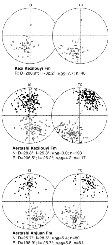
Figure 3. Equal-area plots of the ChRM directions, shown for each section and formation both for in situ (IS) versus tilt-corrected (TC) coordinates. Downward directions are shown as solid symbols, whereas upward directions are shown as
open symbols. Fisher means are indicated for normal (N) and reversed (R) polarities with circles indicating theα95con
For the Aertashi section, the data was separated into two age bins of ~41–36 Ma and ~33–27 Ma, respec-tively, below and above the observed disconformity.
3.3. Reliability Tests
The uniform bedding orientation at both sections precludes a fold test, but to assess the nature of the acquired ChRM directions the reversals test of McFadden and McElhinny [1990] was applied. The two age bins of the Aertashi section both pass with classification B. This indicates a primary magnetization without secondary bias in directions, thus providing reliable results for rotational analysis. As the red beds of the Kezi section have solely yielded reversed ChRM directions, a reversal test cannot be applied. However, a primary origin is likely based on the consistency in the rock magnetic properties and ChRM directions in comparison to the Aertashi samples and because the ChRM directions in geographic coordinate depart significantly from the present-day field orientation.
4. Results
4.1. Rotational Analyses
To evaluate the direction and magnitude of vertical-axis rotations, we compare our well-dated locality-mean directions to expected directions derived at the locality sites from the Eurasian apparent polar wander path (APWP) of according age from Torsvik et al. [2008]. Rotations andflattening have been calculated according to methods of Butler [1992]. The mean inclination values are systematically lower than the 59.0 ± 2.5° expected from the Paleogene Eurasian APWP, yielding 21.5 ± 5.1° to 30.7 ± 3.4° offlattening. This can be interpreted as resulting from inclination shallowing during depositional and compaction processes as observed in numer-ous red beds in Asia [e.g., Dupont-Nivet et al., 2002b; Gilder et al., 2001].
Observed declinations consistently yield clockwise rotations with respect to expected declinations at both sections (Table 1): 21.6 ± 4.2° in 41 to 36 Ma strata then 17.1 ± 6.5° in 33 to 27 Ma strata at the Aertashi section and 14.2 ± 11.5° in 41 to 40 Ma strata at the Kezi section. These results are statistically indistinguishable given the confidence intervals such that it is not possible to infer if the rotation occurred gradually between 41 and 36 Ma; however, we can infer that most of it occurred after 36 Ma. To better understand the tectonic signif-icance of these rotations and their evolution in time and space, they are discussed below in light of a regional review of previous paleomagnetic results
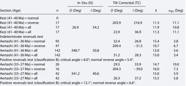
Table 1. Paleomagnetic Mean Directions From the Kezilouyi and Anjuan Formations at the Kezi and Aertashi Sections in
the Southwest Tarim Basina
In Situ (IS) Tilt Corrected (TC)
Section (Age) n D (Deg) I (Deg) D (Deg) I (Deg) k α95(Deg)
Kezi (41–40 Ma) = normal 0
Kezi (41–40 Ma) = reverse 17 203.9 216.9 11.3 11.1
Kezi (41–40 Ma) = all 17 26.9 54.2 11.9 10.8
Kezi (41–40 Ma) = all 17 23.9 36.9 11.3 11.1
Indeterminate reversals test
Aertashi (41–36 Ma) = normal 95 32.4 26.8 15.4 3.8
Aertashi (41–36 Ma) = reverse 47 209.4 31.5 10.7 6.7
Aertashi (41–36 Ma) = all 142 348.7 50.8 12.0 3.6
Aertashi (41–36 Ma) = all 142 31.2 28.3 13.0 3.4
Positive reversals test (classification B); critical angle = 8.0°; normal reverse angle = 5.4°.
Aertashi (33–27 Ma) = normal 26 29.5 33.9 14.7 10.0
Aertashi (33–27 Ma) = reverse 16 204.3 39.0 16.0 7.3
Aertashi (33–27 Ma) = all 42 341.2 40.6 15.0 5.9
Aertashi (33–27 Ma) = all 42 26.3 37.2 15.5 5.8
Positive reversals test (classification B); critical angle = 12.1°; normal reverse angle = 6.6°.
aNote: n = number of sample characteristic remanent magnetization (ChRM) directions averaged to calculate site
mean direction; D = declination and I = inclination of site mean directions for in situ (geographic) and tilt-corrected
(strat-igraphic) coordinates; k = concentration parameter;α95= angular radius of 95% confidence on mean direction. Averages
of site mean directions are given by formation and by polarity (normal and reverse). Reliability is evaluated by the out-come of the reversals test of McFadden and McElhinny [1990].
4.2. Comparison With Previous Paleomagnetic Results Around the Pamir
At the Aertashi section, previous results [Rumelhart et al., 1999; Yin et al., 2000] indicate low amounts (8.4 ± 5.8°) of clockwise rotation from strata sampled stratigraphically above our own sampling and therefore necessarily younger. According to magnetostratigraphic dating of Yin et al. [2002], these rocks have been deposited between ~33 and ~24 Ma implying limited Neogene rotation. Together with our results showing significant clockwise rotations recorded in 41–36 Ma sediments, this suggests that the tectonic mechanism responsible for most of the rotation acquired at the Aertashi section occurred in Oligocene times before ~24 Ma.
To understand whether this rotation is only local or systematically extends regionally we review other results from Cretaceous and younger strata along the eastern Pamir and more generally in the Tarim Basin (Figure 4 and Table 2). Our slightly lower 14.2 ± 11.5° rotation in 41 to 40 Ma strata observed at the Kezi section to the north suggests that clockwise rotations occurred systematically along the West Kunlun Shan with varying degrees of magnitude. However, previous contrasting results have been reported from Cretaceous to Paleogene continental and marine strata at the Yingjisha section only a few kilometers to the north of the Kezi section (Figure 4) [Chen et al., 1992]. At this locality, mean declinations are low and yield no significant rotations when compared to the Eurasian APWP. However, the following evidence suggests that this site may be discarded for inferring a regional tectonic mechanism. This result has been previously associated with local structures departing from the regional trend [Yin et al., 2000]. In addition, the absence of rotation in this site may also relate to the wholesale and regional remagnetization of the marine strata evidenced previously [Bosboom et al., 2013] that would partially bias those data sets. Similarly, Li et al. [2013] recently reported results from a section referred to as the Qimugen section which is the same as the Kezi section reported here. These results are mostly marine sediments from the Kashi Group (i.e., from the levels 300 to 250 m in Li et al., 2013) that have been shown to be biased by remagnetization [Bosboom et al., 2013] yielding erroneously limited amounts of rotation and therefore should be rejected for tectonic analysis. Note that the stratigraphic divisions and the ages reported in Li et al. [2013] must be corrected according to the magnetostratigraphic constraints now available in Bosboom et al. [2013]. Accordingly, marine sediment reported by Li et al. [2013] from the Kashi Group includes the Qimugen, Kalatar, and Wulagen Formations (but not the Bashibulake Formation, which is not present in this part of the basin). Li et al. [2013] also report a few paleomagnetic results from the overlying continental red beds of the Wuqia Group. Unfortunately, these results did not yield an interpretable set of directions, and the stratigraphic position of these rocks is not clear such that it is not possible to compare them with our results. In summary, after discarding results likely biased by
remagnetizations [Chen et al., 1992; Li et al., 2013], paleomagnetic studies from the easternflank of the Pamir indicate systematic clockwise rotations with maximum ~25° magnitude.
By comparison to previous results across the Tarim Basin, it is immediately apparent that these clockwise rotations do not continue systematically into the Tarim Basin. Both senses of rotations are observed in the
Figure 4. Simplified structural map of the Pamir collision zone (modified from Cowgill [2010]) showing the distribution of
paleomagnetic rotations from Cretaceous and Cenozoic strata around the Pamir in Central Asia. Rotations and uncertainties are shown with respect to the Eurasian APWP (see Table 2 for complete list and references). Dark grey indicates Cretaceous data, medium grey indicates Paleogene data, and light grey indicates Neogene data. The results of this study are at the Aertashi (AT) and Kezi (KZ) sections.
Table 2. Review of Paleomagnetic Results From the Tarim Basin Shown for Various Subregionsa
Section Formation
Age Ref.
Site
Location Observed Direction (TC) Reference Pole Rotation
Lat. Long. D I α95 n Test Age Lat. Long. α95 R ± ΔR
(Ma) (°N) (°E) (Deg) (Deg) (Deg) ± (°N) (°E) (Deg) (Deg) (Deg)
Eastern Pamir
Aertashi Wuqia Group <33–24?
Ma
1 38.1 76.4 17.6 36.9 5.0 56 s +f C 30 82.7 152.5 2.8 8.4 ± 5.8
Aertashi Wuqia Group 33–27 Ma * 38.0 76.6 26.3 37.2 5.8 42 s A 30 82.7 152.5 2.8 17.1 ± 6.5
Aertashi Wuqia Group 41–36 Ma * 38.0 76.6 31.2 28.3 3.4 142 s A 40 82.3 150.5 2.8 21.6 ± 4.2
Kezi Wuqia Group 41–40 Ma * 38.4 76.4 23.9 36.9 11.1 17 s n/a 40 82.3 150.5 2.8 14.2 ± 11.5
Yingjisha
Yingjisha-Kezilesu
K 2 38.5 76.4 9.6 38.4 8.0 9 S n/a 100 78.5 179.7 2.7 4.1 ± 8.6
Altyn Tagh
Jianglisai N1 1 38.0 86.5 1.6 39.6 6.7 28 s +f C 20 85.0 137.4 3.0 6.7 ± 7.7
Kuche Basin (Tian Shan)
Yaha Kuche-Xiyu 5.3–1.7 3 41.9 83.3 2.4 54.1 2.4 256 s A 0 87.6 133.6 3.0 4.9 ± 4.7 Yaha Jidike-Xiyu 12.6–5.2 4 41.9 83.3 6.8 43.5 2.6 406 s +f -r 10 87.2 125.0 2.5 9.4 ± 4.0 Section A Jidike-Kuche 16.5–5.7 5 42.0 83.3 2.3 46.1 2.1 66 S +f A 10 87.2 125.0 2.5 4.9 ± 3.7 Section B Kumugeliemu-Jidike 29.0–15.5 5 42.0 83.3 6.0 42.8 6.2 15 S +f C 20 85.0 137.4 3.0 0.3 ± 7.6
Kuche Basin Suweiyi ±N1 6 41.6 83.5 24.6 54.6 10.3 2 S +f 50 79.1 154.2 2.6 10.2 ± 14.7
+ r
Kuche Basin Suweiyi ±E3 6 41.6 83.5 2.2 45.3 13.8 3 S +f 50 79.1 154.2 2.6 12.2 ± 16.1
+ r
Kuche Basin Kumugeliemu ±E1–2 6 41.6 83.5 8.5 39.0 8.9 10 S +f 50 80.9 162.0 2.6 20.7 ± 9.6
+r
Kuche River
Qigu-Kumugeliemu K 7 42.1 83.1 13.8 39.3 3.8 149 s +f 100 78.5 179.7 2.7 1.1 ± 4.8 +r Kuche River-Bestantuogela Kapusaliang Group K 8 42.1 83.2 16.4 29.3 9.5 21 S +f 100 78.5 179.7 2.7 1.5 ± 9.2 C
Kuche Basin Bashenjiqike K2 9 42.0 81.6 16.0 39.0 9.0 4 S +f 75 79.9 171.7 1.5 2.5 ± 9.4
Kezilenuer Channel Bashenjiqike-Kumugeliemu K1 7 42.1 83.1 7.1 60.2 15.1 42 s n/a 70 80.3 181.8 2.7 19.6 ± 25.4 Paicheng Yageliemu-Kelaza J3–K1 9 42.0 81.6 22.0 42.0 9.0 6 S +f 130 75.7 167.7 6.4 2.8 ± 11.9
Kashi Basin (Tian Shan)
Ganghangou Atushi-Xiyu 2.2–1.0 10 39.8 76.2 15.9 32.5 10.6 33 s C 0 87.6 133.6 3.0 13.2 ± 10.6
Boguzihe Atushi-Xiyu 3.6–1.4 10 39.8 76.2 10.6 43.2 1.9 258 s A 0 87.6 133.6 3.0 13.3 ± 3.8
North Kashi Atushi N2 11 39.6 76.0 4.3 40.2 9.0 13 S +f 0 87.6 133.6 3.0 7.0 ± 10.0
North Atushi Atushi N2 11 39.8 76.1 13.1 45.1 7.2 11 S +f 0 87.6 133.6 3.0 15.8 ± 8.8
North Atushi
Kezilouyi-Pakabulake
N1 11 39.8 76.1 16.7 44.6 9.6 10 S +f 10 87.2 125.0 2.5 19.5 ± 11.2
Tuoyon Basin (Tian Shan)
Locality A + B Upper Basalt
Series
E1v 12 40.2 75.3 48.4 49.1 6.6 20 S +f 60 79.0 166.8 2.4 34.2 ± 8.5
Tuoyon Kezilesu Group K1 13 40.2 75.3 37.9 38.6 6.8 5 S +f 125 76.3 175.6 6.2 21.1 ± 9.3
Tuoyon Kezilesu Group K1v 13 40.2 75.3 31.9 49.9 10.6 13 S +f 125 76.3 175.6 6.2 15.1 ± 14.6
Wuqia area
East Kulukeqiati Atushi N2 11 39.8 74.6 14.8 50.6 24.3 5 S +f 0 87.6 133.6 3.0 17.5 ± 32.5
East Kulukeqiati
Kezilouyi-Pakabulake
N1 11 39.8 74.6 11.9 42.0 7.8 15 S +f 10 87.2 125.0 2.5 14.8 ± 8.8
West Wuqia Kashi Group E2 11 39.8 74.7 23.1 47.4 11.1 8 S 40 82.3 150.5 2.8 33.1 ± 13.6
Wuqia area
Yingjisha-Kezilesu
K 2 39.5 75.0 10.3 38.6 8.2 18 S +f 100 78.5 179.7 2.7 3.4 ± 8.8
Central Tarim and Hotan Basin
Maza Tagh Wuqia Group N1 14 38.5 80.5 24.7 29.4 6.2 30 S +f 20 85.0 137.4 3.0 19.1 ± 6.5
Puska Kashi Broup E2 1 37.1 78.4 4.3 24.3 8.4 22 s +f
Cr
50 79.1 154.2 2.6 9.3 ± 7.8
Duwa-Piyaleman
Aertashi-Qimugen
Hotan Basin along the West Kunlun Shan (Puska and Duwa sections) and in central Tarim (Maza Tagh section) that have been attributed equally to either wholesale Tarim block rotation or recent local structures [Dupont-Nivet et al., 2002a; Gilder et al., 1996; Rumelhart et al., 1999; Yin et al., 2000]. Along the left-lateral Altyn Tagh fault little to no rotations are observed locally and regionally [Dupont-Nivet et al., 2002b, 2003; Dupont-Nivet et al., 2004; Rumelhart et al., 1999; Yin et al., 2000]. Along the southern Tian Shan from the Wuqia area to the Kashi and Kuche Basins further east, rotations are predominantly counterclockwise or insignificant and have been associated with Neogene left-lateral transpressive shear along the Tian Shan range itself [Charreau et al., 2006; Chen et al., 2002, 1992; Fang et al., 1998; Huang et al., 2009, 2010; Li et al., 1988; Peng et al., 2006; Tan et al., 2003]. Departing from this general trend are clockwise rotations reported from Cretaceous-Paleocene volcanic rocks in the Tuoyun Basin associated with the right-lateral Talas-Ferghana fault [Gilder et al., 2003; Huang et al., 2005]. In summary, clockwise rotations observed along the eastern Pamir limb do not extend systematically and regionally into the Tarim Basin, where Cenozoic rotations are generally low and associated with local structures (Figure 5).
On the western side of the Pamir salient (Figure 4 and Table 3), Cretaceous to Cenozoic results are strikingly different with systematic counterclockwise rotations extending widely throughout the Afghan-Tajik and Ferghana Basins [Bazhenov and Mikolaichuck, 2002; Bazhenov et al., 1994; Burtman, 2000; Pozzi and Feinberg, 1991; Thomas et al., 1993, 1994]. These rotations show a clear westward decreasing trend ranging from ~ 60° along the Darvaz fault on the eastern Pamir limb to no significant rotation over ~300 km to the west (Figure 5). Structural and kinematic reconstructions show that this trend can be reconciled by the relative displacement and rotation offinite crustal thrust sheets in response to the regional left-lateral shear related to the northward Pamir indentation [Bourgeois et al., 1997; Thomas et al., 1994].
In summary, tectonic rotations around the Pamir show a strong asymmetry between regionally ex-tensive systematic counterclockwise rotation in Cretaceous to Neogene strata on the western side of the Pamir contrasting with Oligocene clockwise rotations concentrated along the eastern Pamir limb that do not extend far eastward into the Tarim Basin (Figures 4 and 5).
5. Discussion
The curved geometry of the Pamir has been related to end-member models: (1) rotation by oroclinal bending or radial thrusting of the Pamir arc [Bazhenov and Burtman, 1986; Bazhenov et al., 1994; Robinson et al., 2004; Strecker et al., 1995] or (2) transfer faulting in-duced by opposite shear along the
Figure 5. Vertical-axis rotations plotted against approximate east-west dis-tance from the Kashgar-Yecheng transfer system (KYTS) marking the eastern margin of the Pamir and the Darvaz fault marking its western margin. Solid lines indicate the mean observed rotation on either side of the Pamir, showing
that the average varies from 32.2° anticlockwise rotation in the Afghan-Tajik
Basin on the western side to 6.5° clockwise rotation in the Tarim Basin on the eastern side. As in Figure 5 dark grey indicates Cretaceous data, medium grey indicates Paleogene data, and light grey indicates Neogene data. The results of this study are shown by circles (instead of squares).
Notes to Table 2:
aAge of sampled formation given by numbers when magnetostratigraphic control on age span is available or given by epoch notation otherwise (K1 = Early
Cretaceous; K2 = Late Cretaceous; E1 = Paleocene; E2 = Eocene; E3 = Oligocene; N1 = Miocene; N2 = Pliocene; v = data from volcanic rocks; ± = age estimated).
Lat. = latitude and Long. = longitude of section location; D = declination and I = inclination for tilt-corrected (stratigraphic coordinates);α95= angular radius of
95% confidence on mean direction; n = number of sites (S) or samples (s) used to calculate mean directions; Test refers to the outcome of reversals (r) or fold test
(f) as positive (+), negative ( ), not applicable (n/a), or the classification (A, B, or C) of the reversals test of McFadden and McElhinny [1990]. Reference poles are the
Eurasian paleomagnetic poles from Torsvik et al. [2008]. Shaded reference pole data indicate that mean poles have been calculated for long age spans of more
than 30 Myr. R = vertical-axis rotation (clockwise is positive) andΔR = 95% confidence limit on rotation. References (Ref.): * = this study; 1, Rumelhart et al.
[1999]; 2, Chen et al. [1992]; 3, Huang et al. [2010]; 4, Charreau et al. [2006]; 5, Huang et al. [2006]; 6, Fang et al. [1998]; 7, Peng et al. [2006]; 8, Tan et al. [2003]; 9, Li et al. [1988]; 10, Chen et al. [2002]; 11, Huang et al. [2009]; 12, Huang et al. [2005]; 13, Gilder et al. [2003]; 14, Dupont-Nivet et al. [2002a]; 15, Gilder et al. [1996].
Figure 6. Proposed tectonic and paleogeographic evolution of the Pamir salient (modified after Cowgill [2010]), based upon results of this study and previous studies of the proto-Paratethys Sea [Bosboom, 2013; Burtman, 2000; Burtman et al., 1996; Coutand et al., 2002; Lan and Wei, 1995; Tang et al., 1989]. The paleogeographic evolution is shown in the lower graphs with the approximate paleogeographic extent of the sea shaded in light grey for the (a) Early Eocene and (b) before its final retreat in the Late Eocene. The upper graphs show the corresponding kinematic models. The Pamir evolved symmetri-cally with radial thrusting causing rotation on both sides until the Late Oligocene. In the Late Oligocene to Early Miocene, deformation became asymmetric with ceased clockwise rotation in the Tarim Basin and continued anticlockwise rotation on the western side in the Afghan-Tajik Basin. This change is attributed to the initiation of slip along the Kashgar-Yecheng transfer system (KYTS) along the eastern Pamir in response to slab tear of the underriding Alai plate. See the discussion for a complete overview of this proposed evolution.
Table 3. Review of Paleomagnetic Results From Tajikistan and Kyrgyzstan Shown for Various Basinsa
Section
Age Ref. Site Location Observed Direction (TC) Reference Pole Rotation
Lat. Long. D I α95 n Test Age Lat. Long. α95 R ± ΔR
(Ma) (°N) (°E) (Deg) (Deg) (Deg) ± (°N) (°E) (Deg) (Deg) (Deg)
Afghan-Tajik Basin (Tajikistan)
Kalinabad N1 1 38.0 69.0 50.0 33.0 9.0 13 L n/a 20 85.0 137.4 3.0 56.0 ± 9.1 Aksu N1 1 38.0 68.6 24.0 33.0 13.0 5 L n/a 20 85.0 137.4 3.0 30.1 ± 12.8 Pyryagata N1 1 37.7 68.3 24.0 30.0 12.0 6 L + (f) 20 85.0 137.4 3.0 30.0 ± 11.5 Pulkhakim N1 1 39.1 67.5 11.0 35.0 13.0 10 L + (f) 20 85.0 137.4 3.0 17.2 ± 13.1 + (r) Tukaynaron E3- N1 1 38.8 69.6 25.0 30.0 11.0 10 L + (f) 20 85.0 137.4 3.0 31.1 ± 10.7 + (r)
South Darvaz E2- N1 1 37.7 68.1 56.0 32.0
21.0 3 L + (r) 25 84.1 147.1 2.8 63.4 ± 20.2
Nurek Dam + Nurek
Pass + Gissar + Ragoon
K1 2 38.3 68.9 9.5 55.4 4.0 53 s + (f) 125 76.3 175.6 6.2 25.2 ± 8.2
Aksay Basin (Kyrgyzstan)
Tekelik E2-3 3 14.6 54.0 3.8 18 L + (f) 40 81.7 154.5 2.8 11.0 ± 5.7
Chatkal Basin (Kyrgyzstan)
Chatkal E 4 41.7 71.2 8.0 42.0 9.0 10 L n/a 40 82.3 150.5 2.8 18.3 ± 10.2
Ferghana Basin (Kyrgyzstan) Tash-Kumyr +
Ala-Buka + South Ferghana
E 4 41.1 71.2 18.0 34.0 9.0 9 L + (f) 40 82.3 150.5 2.8 28.2 ± 9.2
+ (r) Issyk-Kul Basin (Kyrgyzstan)
Dzhety-Ogyuz + Karakoo + Toru Aygyr
E2- N1 4 42.4 77.1 2.0 49.0 6.0 13 L + (f)
30 82.7 152.5 2.8
7.8 ± + (r) 8.0
Naryn Basin (Kyrgyzstan) Karabulan +
Djaman-Davan + Makmal
E 4 41.2 74.7 5.0 37.0 11.0 16 L + (f) 40 82.3 150.5 2.8 5.2 ± 11.5
+ (r)
eastern (sinistral) and western (dextral) margins of the Pamir [Burtman and Molnar, 1993; Searle, 1996]. A hybrid of the above-mentioned end-member models has been recently proposed by Cowgill [2010]. This hybrid model involves northwest directed radial thrusting on the Pamir’s western flank and transpressional dextral slip transfer faulting along the Kashgar-Yecheng transfer system (KYTS) on its easternflank. This model is supported by Li et al. [2013] albeit based on data biased by remagnetization, yielding erroneously no rotation of the easternflank since Paleocene times. In contrast, our reliable results indicate a regional Oligocene clockwise rotation and suggest this rotation mostly ceased in Neogene times. Our results thus imply a two-stage evolution that can be reconciled by the following model (Figure 6). After the Early Eocene initiation of the Pamir indentation associated with the Indo-Asia collision, the deformation propagated from Late Eocene to Late Oligocene into a proto Tajik-Tarim foreland basin inducing symmetric rotations by radial thrusting on either side of the nascent Pamir salient. By Early Miocene time, the observed asymmetry in the pattern of ro-tations indicates that radial thrusting did not continue east of the Pamir as it did to the west but was replaced by a mechanism such as strike-slip transfer faulting with limited distributed shear.
This model is consistent in time with the recently dated paleogeographic evolution of the proto-Paratethys Sea (Figure 6), involving its stepwise westward retreat in the Eocene forced by short-term eustacy and long-term tectonism related to the Pamir indentation [Bosboom et al., 2013, 2011; Bosboom, 2013]. In the Early Eocene marine deposits had their maximum extent reaching far eastward into the Tarim Basin [Burtman, 2000; Burtman et al., 1996; Lan and Wei, 1995; Tang et al., 1989]. The maximum extent of each of the next incursions reached successively less far into the Tarim Basin; the last one reaching only the westernmost Tarim Basin in Late Eocene times [Bosboom, 2013]. The complete disappearance of the sea from Central Asia is poorly constrained to the Oligocene, followed by mostly continental deposition in Late Oligocene and Early Miocene times [e.g., Burtman, 2000; Burtman et al., 1996; Coutand et al., 2002]. This suggests that the observed Oligocene rotations may be related to tectonism propagating northward after the Late Eocene regional sea retreat and disappearance. After the Oligocene, a major right-lateral strike-slip system is reported to start in the Early Miocene along the eastern Pamir [Sobel and Dumitru, 1997; Sobel et al., 2011]. This is supported locally at Aertashi by the initiation of proximal coarse-grained clastic deposition from ~24 Ma [Yin et al., 2002] interpreted as a response to the initial dextral slip between the Pamir and the Tarim Basin [Cowgill, 2010]. Neogene decoupling of the Pamir from Tarim along this major strike-slip system is corroborated by the limited rotations accumulated in the Neogene with no regional consistency east of the Pamir into the Tarim Basin. This probably also corresponds to an important geodynamic change consistent with Early Miocene ages of exhumation and deformation in the eastern Pamir, Western Kunlun Shan, and Tian Shan [e.g., De Grave et al., 2012; Sobel and Dumitru, 1997; Sobel et al., 2006].
Finally, our results are consistent in time and space with the recently proposed intracontinental subduction models of Pamir evolution [Negredo et al., 2007; Sobel et al., 2013]. In these models, Eocene break off of the north dipping Indian slab associated with the Indo-Asia collision is followed by a period of intense deformation related to subduction inversion and the initiation of a new intracontinental south dipping subduction at ~25 Ma [Negredo et al., 2007]. This is in good agreement with the observed Oligocene rotations with radial thrusting on either side of the nascent Pamir salient. Sobel et al. [2011, 2013] further suggest that the Pamir indentation could have been driven by roll back of the south dipping slab starting at ~25 Ma with a curved slab on its western flank and the initiation of a slab tear (or STEP, Subduction-Transform Edge Propagator as defined by Govers and Wortel [2005]) along its easternflank linked to the dextral KYTS (Figure 6). This is consistent with the observed asymmetric distribution rotations starting in Miocene times. On the westernflank, regionally distributed counterclockwise rotations would have continued into the Miocene in response to the retreating curved slab. On the easternflank, clockwise rotations would have stopped after the Oligocene when the STEP initiated yielding a strike-slip system with limited distributed shear.
6. Conclusions
Arc-shaped ranges may result from a wide array of potential tectonic mechanisms yielding characteristic patterns of vertical-axis rotations that can be quantified using paleomagnetism [Weil and Sussman, 2004]. The case of the Pamir range is particularly interesting because of the asymmetry in observed rotations on either side of the arc resulting from contrasting mechanisms but yielding a seemingly symmetric shape in map view. Another peculiar aspect, suggested here, is the shift of the rotational pattern from symmetric to
asymmetric in the Late Oligocene to Early Miocene that enables us to identify a major change in geodynamic regime. This shows generally that regular arcuate structures may in fact be the result of a protracted history and cannot be assumed to have evolved regularly since inception. The analysis of vertical-axis rotations using paleomagnetism provides a tool to quantify the evolution of arcuate belts in time that can be particularly useful to constrain geodynamic models of these structures [e.g., Schellart and Rawlinson, 2010].
References
Amidon, W. H., and S. A. Hynek (2010), Exhumational history of the north central Pamir, Tectonics, 29, TC5017, doi:10.1029/2009TC002589. Bazhenov, M. L., and A. V. Mikolaichuck (2002), Paleomagnetism of Paleogene basalts from the Tien Shan, Kyrgyzstan: Rigid Eurasia and
dipole geomagneticfield, Earth Planet. Sci. Lett., 195, 155–166, doi:10.1016/S0012-821X(01)00586-6.
Bazhenov, M. L., and V. S. Burtman (1986), Tectonics and paleomagnetism of structural arcs of the Pamir-Punjab syntaxis, J. Geodyn., 5(3), 383–396, doi:10.1016/0264-3707(86)90017-7.
Bazhenov, M. L., H. Perroud, A. Chauvin, V. S. Burtman, and J. C. Thomas (1994), Paleomagnetism of Cretaceous red beds from Tadzhikistan and Cenozoic deformation due to India-Eurasia collision, Earth Planet. Sci. Lett., 124, 1–18, doi:10.1016/SSDI0012-821X(94)00072-7. Bershaw, J., C. N. Garzione, L. Schoenbohm, G. Gehrels, and L. Tao (2012), Cenozoic evolution of the Pamir plateau based on stratigraphy,
zircon provenance, and stable isotopes of foreland basin sediments at Oytag (Wuyitake) in the Tarim Basin (west China), J. Asian Earth Sci. 44, 136–148, doi:10.1016/j.jseaes.2011.04.020.
Bosboom, R. E. (2013), Paleogeography of the Central Asian Proto-Paratethys Sea in the Eocene, 225 pp., Utrecht University, Utrecht. Bosboom, R. E., G. Dupont-Nivet, A. J. P. Houben, H. Brinkhuis, G. Villa, O. Mandic, M. Stoica, W.-J. Zachariasse, Z. Guo, and C. Li (2011), Late
Eocene sea retreat from the Tarim Basin (West China) and concomitant Asian paleoenvironmental change, Palaeogeogr. Palaeoclimatol. Palaeoecol., 299, 385–398, doi:10.1016/j.palaeo.2010.11.019.
Bosboom, R., et al. (2013), Linking Tarim Basin sea retreat (west China) and Asian aridification in the Late Eocene, Basin Research, doi:10.1111/ bre.12054, in press.
Bosboom, R. E., H. A. Abels, C. Hoorn, B. C. J. van den Berg, Z. Guo, and G. Dupont Nivet (2014), Aridification in continental Asia after the Middle Eocene Climatic Optimum (MECO), Earth Planet. Sci. Lett., 389, pp. 34–42.
Bourgeois, O., P. R. Cobbold, D. Rouby, J.–C. Thomas, and V. Shein (1997), Least squares restoration of Tertiary thrust sheets in map view, Tajik depression, central Asia, J. Geophys. Res., 102(B12), 27,553–27,527,27573, doi:10.1029/97JB02477.
Bureau of Geology and Mineral Resources of Xinjiang Uygur Autonomous Region (1993), Regional Geology of Xinjiang Uygur Autonomous Region, Geological House, Beijing.
Burtman, V. S. (2000), Cenozoic crustal shortening between the Pamir and Tien Shan and a reconstruction of the Pamir–Tien Shan transition zone for the Cretaceous and Palaeogene, Tectonophysics, 319(2), 69–92, doi:10.1016/S0040-1951(00)00022-6.
Burtman, V. S., and P. Molnar (1993), Geological and geophysical evidence for deep subduction of continental crust beneath the Pamir, Geol. Soc. Am. Special Pap., 281, 1–76.
Burtman, V. S., S. F. Skobelev, and P. Molnar (1996), Late Cenozoic slip on the Talas-Ferghana fault, the Tien Shan, central Asia, Geol. Soc. Am. Bull., 108(8), 1004–1021, doi:10.1130/0016-7606(1996)108<1004:LCSOTT>2.3.CO;2.
Butler, R. F. (1992), Paleomagnetism: Magnetic Domains to Geologic Terranes, 238 pp., Blackwell Scientific Publications, Boston. Charreau, J., Y. Chen, S. Gilder, S. Dominguez, J.-P. Avouac, S. Sen, D. Sun, Y. Li, and W.-M. Wang (2005), Magnetostratigraphy and rock
magnetism of the Neogene Kuitun He section (northwest China): Implications for Late Cenozoic uplift of the Tianshan mountains, Earth Planet. Sci. Lett., 230(1–2), 177–192, doi:10.1016/j.epsl.2004.11.002.
Charreau, J., S. Gilder, Y. Chen, S. Dominguez, J. P. Avouac, S. Sen, and M. Jolivet (2006), Magnetostratigraphy of the Yaha section, Tarim Basin (China): 11 Ma acceleration in erosion and uplift of the Tianshan Mountains, Geology, 34(3), 181–184, doi:10.1130/G22106.1.
Chen, J., D. W. Burbank, K. M. Scharer, E. Sobel, J. Yin, C. Rubin, and R. Zhao (2002), Magnetochronology of the upper cenozoic strata in the Southwestern Chinese Tian Shan: Rates of Pleistocene folding and thrusting, Earth Planet. Sci. Lett., 195(1–2), 113–130.
Chen, Y., J. P. Cogné, and V. Courtillot (1992), New Cretaceous paleomagnetic results from the Tarim basin, northwestern China, Earth Planet. Sci. Lett., 114(1), 17–38, doi:10.1016/0012-821X(92)90149-P.
Coutand, I., M. R. Strecker, R. Arrowsmith, G. Hilley, R. C. Thiede, A. Korjenkov, and M. Omuraliev (2002), Late Cenozoic tectonic development of the intramontane Alai Valley, (Pamir-Tien Shan region, central Asia): An example of intracontinental deformation due to the Indo-Eurasia collision, Tectonics, 21(6), 3-1–3-19, doi:10.1029/2002TC001358.
Cowgill, E. (2010), Cenozoic right-slip faulting along the eastern margin of the Pamir salient, northwestern China, Geol. Soc. Am. Bull., 122(1–2), 145–161, doi:10.1130/B26520.1.
De Grave, J., S. Glorie, A. Ryabinin, F. Zhimulev, M. M. Buslov, A. Izmer, M. Elburg, and F. Vanhaecke (2012), Late Palaeozoic and Meso-Cenozoic tectonic evolution of the Southern Kyrgyz Tien Shan: Constraints from multi-method thermochronology in the Trans-Alai, Turkestan-Alai Section and the Southeastern Ferghana Basin, J. Asian Earth Sci., 44, 149–168, doi:10.1016/j.jseaes.2011.04.019. Dupont-Nivet, G., Z. Guo, R. F. Butler, and C. Jia (2002a), Discordant paleomagnetic direction in Miocene rocks from the central Tarim Basin:
Evidence for local deformation and inclination shallowing, Earth Planet. Sci. Lett., 199(3–4), 473–482, doi:10.1016/S0012-821X(02)00566-6. Dupont-Nivet, G., R. F. Butler, A. Yin, and X. Chen (2002b), Paleomagnetism indicates no Neogene rotation of the Qaidam Basin in North Tibet
during Indo-Asian Collision, Geology, 30(3), 263–266, doi:10.1130/0091-7613(2002).
Dupont-Nivet, G., R. F. Butler, A. Yin, and X. Chen (2003), Paleomagnetism indicates no Neogene rotation of the Northeastern Tibetan plateau, J. Geophys. Res., 108(B8), 2386, doi:10.1029/2003JB002399.
Dupont-Nivet, G., R. F. Butler, A. Yin, D. Robinson, Y. Zhang, W. S. Qiao, and J. Melosh (2004), Concentration of crustal displacement along a weak Altyn Tagh fault: Evidence from paleomagnetism of the northern Tibetan Plateau, Tectonics, 23, TC1020, doi:10.1029/ 2002TC001397.
Fang, D., P. Wang, Z. Shen, and X. Tan (1998), Cenozoic paleomagnetic results and phanerozoic apparent polar wandering path of Tarim Block, Sci. Chin. Ser. D, 41(2), 105–112, doi:10.1007/BF02984518.
Fisher, R. A. (1953), Dispersion on a sphere, Proc. R. Soc. London Ser. A Math. Phys. Sci., 217(1130), 295–305, doi:10.1098/rspa.1953.0064. Gao, Z., K. Chen, and J. Wei (2000), The Lithostratigraphic Dictionary of China, 627 pp., Press of Geological University, Beijing.
Gilder, S., X. Zhao, R. Coe, Z. Meng, V. Courtillot, and J. Besse (1996), Paleomagnetism and tectonics of the southern Tarim Basin, northwestern China, J. Geophys. Res., 101(B10), 22,015–22,031, doi:10.1029/96JB01647.
Acknowledgments
This project was funded by the Netherlands Organization for Scientific Research (NWO) with grants to Roderic Bosboom and Guillaume Dupont-Nivet. We also acknowledge funding from the Cai Yuanpei program of the French ministries of foreign affairs and of higher education and research and the Chinese ministry of education. We would like to thank Cor Langereis, Wout Krijgsman, Arjen Grothe, Beibei Zhu, and Ziya Yang for their contributions in thefield. Tom Mullender and Mark Dekkers are thanked for their assistance in the paleomagnetic laboratory. We thank Alex Robinson and an anony-mous reviewer for detailed and thoughtful comments.
Gilder, S., Y. Chen, and S. Sen (2001), Oligo-Miocene magnetostratigraphy and rock magnetism of the Xishuigou section, Subei (Gansu Province, western China) and implications for shallow inclinations in central Asia, J. Geophys. Res., 106(B12), 30,505–30,522, doi:10.1029/2001JB000325. Gilder, S., Y. Chen, J.-P. Cogne, X. Tan, V. Courtillot, D. Sun, and Y. Li (2003), Paleomagnetism of Upper Jurassic to Lower Cretaceous volcanic and sedimentary rocks from the western Tarim Basin and implications for inclination shallowing and absolute dating of the M-0 (ISEA?) chron, Earth Planet. Sci. Lett., 206(3–4), 587–600, doi:10.1016/S0012-821X(02)01074-9.
Govers, R., and M. J. R. Wortel (2005), Lithosphere tearing at STEP faults: Response to edges of subduction zones, Earth Planet. Sci. Lett., 236(1), 505–523, doi:10.1016/j.epsl.2005.03.022.
Gradstein, F. M., J. G. Ogg, M. Schmitz, and G. Ogg (2012), A Geological Time Scale 2012, vol. 1 and 2, 1144 pp., Elsevier, Amsterdam. Graham, S. A., C. P. Chamberlain, Y. J. Yue, B. D. Ritts, A. D. Hanson, T. W. Horton, J. R. Waldbauer, M. A. Poage, and X. Feng (2005), Stable isotope
records of Cenozoic climate and topography, Tibetan plateau and Tarim basin, Am. J. Sci., 305(2), 101–118, doi:10.2475/ajs.305.2.101. Hao, Y. C., and X. L. Zeng (1984), On the evolution of the west Tarim gulf from Mesozoic to Cenozoic in terms of characteristics of
forami-niferal fauna, Acta Micropalaeontologica Sin., 1(1), 1–13.
Heermance, R. V., J. Chen, D. W. Burbank, and C. Wang (2007), Chronology and tectonic controls of Late Tertiary deposition in the south-western Tian Shan foreland, NW China, Basin Res., 19(4), 599–632, doi:10.1111/j.1365-2117.2007.00339.x.
Hendrix, M. S., S. A. Graham, A. R. Carroll, E. R. Sobel, C. L. Mcknight, B. J. Schulein, and Z. Wang (1992), Sedimentary record and climatic implications of recurrent deformation in the Tian Shan: Evidence from Mesozoic strata of the north Tarim, south Junggar, and Turpan basins, northwest China, Geol. Soc. Am. Bull., 104(1), 53–79, doi:10.1130/0016-7606(1992)104<0053:SRACIO>2.3.CO;2.
van Hinsbergen, D. J. J., P. C. Lippert, G. Dupont-Nivet, N. McQuarrie, P. V. Doubrovine, W. Spakman, and T. H. Torsvik (2012), Greater India Basin hypothesis and a two-stage Cenozoic collision between India and Asia, Proc. Natl. Acad. Sci. U. S. A., 109(20), 7659–7664, doi:10.1073/ pnas.1117262109.
Huang, B., J. D. A. Piper, Y. Wang, H. He, and R. Zhu (2005), Paleomagnetic and geochronological constraints on the post-collisional northward convergence of the southwest Tian Shan, NW China, Tectonophysics, 409(1–4), 107–124, doi:10.1016/j.tecto.2005.08.018.
Huang, B., J. D. A. Piper, S. Peng, T. Liu, Z. Li, Q. Wang, and R. Zhu (2006), Magnetostratigraphic study of the Kuche Depression, Tarim Basin, and Cenozoic uplift of the Tian Shan Range, Western China, Earth Planet. Sci. Lett., 251(3–4), 346–364, doi:10.1016/j. epsl.2006.09.020.
Huang, B., J. D. A. Piper, and R. Zhu (2009), Paleomagnetic constraints on neotectonic deformation in the Kashi depression of the western Tarim Basin, NW China, Int. J. Earth Sci., 98(6), 1469–1488, doi:10.1007/s00531-008-0401-5.
Huang, B., J. D. A. Piper, Q. Qiao, H. Wang, and C. Zhang (2010), Magnetostratigraphic and rock magnetic study of the Neogene upper Yaha Section, Kuche Depression (Tarim Basin): Implications to formation of the Xiyu Conglomerate Formation, NW China, J. Geophys. Res., 115, B01101, doi:10.1029/2008JB006175.
Jia, C., G. Wei, L. Wang, D. Jia, and Z. Guo (1997), Tectonic characteristics and petroleum, Tarim basin, China, 295 pp., Petroleum Industry Press, Beijing. Jia, C., S. Zhang, and S. Wu (2004), Stratigraphy of the Tarim Basin and Adjacent Areas, 540 pp., Science Press, Beijing.
Kent-Corson, M. L., B. D. Ritts, G. Zhuang, P. M. Bovet, S. A. Graham, and C. Page Chamberlain (2009), Stable isotopic constraints on the tectonic, topographic, and climatic evolution of the northern margin of the Tibetan Plateau, Earth Planet. Sci. Lett., 282(1–4), 158–166, doi:10.1016/j.epsl.2009.03.011.
Kirschvink, J. L. (1980), The least-square line and plane and the analysis of paleomagnetic data, Geophys. J. R. Astron. Soc., 62, 699–718. Lan, X., and J. Wei (Eds) (1995), Late Cretaceous-Early Tertiary Marine Bivalve Fauna From the Western Tarim Basin, 212 pp., Chinese Science
House, Beijing.
Li, Y., Z. Zhang, M. McWilliams, R. Sharps, Y. Zhai, Y. Li, Q. Li, and A. Cox (1988), Mezosoic paleomagnetic results of the Tarim craton: Tertiary relative motion between China and Siberia?, Geophys. Res. Lett., 15(3), 217–220, doi:10.1029/GL015i003p00217.
Li, Z., L. Ding, P. C. Lippert, and H. Wei (2013), Paleomagnetic constraints on the Cenozoic kinematic evolution of the Pamir plateau from the Western Kunlun Shan foreland, Tectonophysics, 603, 257–271, doi:10.1016/j.tecto.2013.05.040.
Mao, S., and G. Norris (1988), Late Cretaceous-Early Tertiary Dinoflagellates and Acritarchs From the Kashi Area, Tarim Basin, Xinjiang Province, China, 93 pp., Royal Ontario Museum, Toronto.
McFadden, P. L., and M. W. McElhinny (1990), Classification of the reversal test in palaeomagnetism, Geophys. J. Int., 103(3), 725–729, doi:10.1111/j.1365-246X.1990.tb05683.x.
Negredo, A. M., A. Replumaz, A. Villasenor, and S. Guillot (2007), Modeling the evolution of continental subduction processes in the Pamir-Hindu Kush region, Earth Planet. Sci. Lett., 259(1–2), 212–225, doi:10.1016/j.epsl.2007.04.043.
Peng, S., Z. Li, B. Huang, T. Liu, and Q. Wang (2006), Magnetostratigraphic study of Cretaceous depositional succession in the northern Kuqa Depression, Northwest China, Chinese Sci. Bull., 51(1), 97–107, doi:10.1007/s11434-005-0340-5.
Pozzi, J. P., and H. Feinberg (1991), Paleomagnetism in the Tajikistan: Continental shortening of European margin in the Pamirs during Indian Eurasian collision, Earth Planet. Sci. Lett., 103(1–4), 365–378, doi:10.1016/0012-821X(91)90173-F.
Ritts, B. D., Y. Yue, S. A. Graham, E. R. Sobel, O. A. Abbink, and D. Stockli (2008), From sea level to high elevation in 15 million years: Uplift history of the northern Tibetan Plateau margin in the Altun Shan, Am. J. Sci., 308(5), 657–678, doi:10.2475/05.2008.01.
Robinson, A. C., A. Yin, C. E. Manning, T. M. Harrison, S.–. H. Zhang, and X.-F. Wang (2004), Tectonic evolution of the northeastern Pamir: Constraints from the northern portion of the Cenozoic Kongur Shan extensional system, western China, Geol. Soc. Am. Bull., 116(7–8), 953–973, doi:10.1130/B25375.1.
Robinson, D. M., G. Dupont-Nivet, G. E. Gehrels, and Y. Zhang (2003), The Tula Uplift, northwestern China: Evidence for regional tectonism of the northern Tibetan Plateau during Late Mesozoic–Early Cenozoic time, Geol. Soc. Am. Bull., 115(1), 35–47, doi:10.1130/0016-7606(2003) 115<0035:TTUNCE>2.0.CO;2.
Rumelhart, P. E. (2000), Cenozoic vertical-axis rotation of the Altyn Tagh fault system, Geology, 28(5), 480–480.
Rumelhart, P. E., A. Yin, E. Cowgill, R. F. Butler, Q. Zhang, and X.-F. Wang (1999), Cenozoic vertical-axis rotation of the Altyn Tagh fault system, Geology, 27(9), 819–822, doi:10.1130/0091-7613(1999)027<0819:CVAROT>2.3.CO;2.
Schellart, W. P., and N. Rawlinson (2010), Convergent plate margin dynamics: New perspectives from structural geology, geophysics and geodynamic modelling, Tectonophysics, 483(1–2), 4–19, doi:10.1016/j.tecto.2009.08.030.
Searle, M. P. (1996), Geological evidence against large-scale pre-Holocene offsets along the Karakorum Fault: Implications for the limited extrusion of the Tibetan plateau, Tectonics, 15(1), 171–186, doi:10.1029/95TC01693.
Sippl, C., B. Schurr, X. Yuan, J. Mechie, F. M. Schneider, M. Gadoev, S. Orunbaev, I. Oimahmadov, C. Haberland, and U. Abdybachaev (2013), Geometry of the Pamir-Hindu Kush intermediate-depth earthquake zone from local seismic data, J. Geophys. Res. Solid Earth, 118, 1438–1457, doi:10.1002/jgrb.50128.
Sobel, E. R., and T. A. Dumitru (1997), Thrusting and exhumation around the margins of the western Tarim basin during the India-Asia col-lision, J. Geophys. Res., 102(B3), 5043–5063, doi:10.1029/96JB03267.
Sobel, E. R., J. Chen, and R. V. Heermance (2006), Late Oligocene–Early Miocene initiation of shortening in the Southwestern Chinese Tian Shan: Implications for Neogene shortening rate variations, Earth Planet. Sci. Lett., 247(1–2), 70–81, doi:10.1016/j.epsl.2006.03.048. Sobel, E. R., L. M. Schoenbohm, J. Chen, R. Thiede, D. F. Stockli, M. Sudo, and M. R. Strecker (2011), Late Miocene–Pliocene deceleration of
dextral slip between Pamir and Tarim: Implications for Pamir orogenesis, Earth Planet. Sci. Lett., 304(3–4), 369–378, doi:10.1016/j. epsl.2011.02.012.
Sobel, E. R., J. Chen, L. M. Schoenbohm, R. Thiede, D. F. Stockli, M. Sudo, and M. R. Strecker (2013), Oceanic-style subduction controls Late Cenozoic deformation of the Northern Pamir orogen, Earth Planet. Sci. Lett., 363, 204–218, doi:10.1016/j.epsl.2012.12.009.
Strecker, M. R., W. Frisch, M. W. Hamburger, L. Ratchbacher, S. Semiletkin, A. Zamoruyev, and N. Sturchio (1995), Quaternary deformation in the eastern Pamir, Tadzhikistan and Kygyzstan, Tectonics, 14(5), 1061–1079, doi:10.1029/95TC00927.
Tan, X., K. P. Kodama, H. Chen, D. Fang, D. Sun, and Y. Li (2003), Paleomagnetism and magnetic anisotropy of Cretaceous red beds from the Tarim basin, northwest China: Evidence for a rock magnetic cause of anomalously shallow paleomagnetic inclinations from Central Asia, J. Geophys. Res., 108(B2), 2107, doi:10.1029/2001JB001608.
Tang, T., H. Yang, X. Lan, C. Yu, Y. Xue, Y. Zhang, L. Hu, S. Zhong, and J. Wei (1989), Marine Late Cretaceous and Early Tertiary Stratigraphy and Petroleum Geology in Western Tarim Basin, China, 141 pp., Science Press, Beijing.
Thomas, J.–C., H. Perroud, P. R. Cobbold, M. L. Bazhenov, V. S. Burtman, A. Chauvin, and I. S. Sadybakasov (1993), A paleomagnetic study of Tertiary formations from the Kyrgyz Tien-Shan and its tectonic implications, J. Geophys. Res., 98(B6), 9571–9589, doi:10.1029/ 92JB02912.
Thomas, J.–C., A. Chauvin, D. Gapais, M. L. Bazhenov, H. Perroud, P. R. Cobbold, and V. S. Burtman (1994), Paleomagnetic evidence for Cenozoic block rotations in the Tadjik depression (Central Asia), J. Geophys. Res., 99(B8), 15,141–15,160, doi:10.1029/94JB00901. Tian, Z., G. Chai, and Y. Kang (1989), Tectonic evolution of the Tarim basin, in Chinese Sedimentary Basins, edited by X. Zhu, pp. 33–42 ,
Elsevier, Amsterdam.
Torsvik, T. H., R. D. Muller, R. Van der Voo, B. Steinberger, and C. Gaina (2008), Global plate motion frames: Toward a unified model, Rev. Geophys., 46, RG3004, doi:10.1029/2007RG000227.
Wei, H.–. H., Q.-R. Meng, L. Ding, and Z.-Y. Li (2013), Tertiary evolution of the western Tarim basin, northwest China: A tectono-sedimentary response to northward indentation of the Pamir salient, Tectonics, 32, 558–575, doi:10.1002/tect.20046.
Weil, A. B., and A. J. Sussman (2004), Classifying curved orogens based on timing relationships between structural development and vertical-axis rotations, Orogenic curvature integrating paleomagnetic struct. analyses, 383, 1–16.
Yang, H., X. Jiang, and S. Lin (1995), Late Cretaceous–Early Tertiary ostracod fauna from western Tarim Basin, south Xinjiang, China, 173 pp., Science Press, Beijing.
Yang, Y., and M. Liu (2002), Cenozoic deformation of the Tarim plate and the implications for mountain building in the Tibetan plateau and the Tian Shan, Tectonics, 21(6), 1059, doi:10.1029/2001TC001300.
Ye, D., et al. (1996), Tertiary in Petroliferous Regions of China, 375 pp., Petroleum Industry Press, Beijing.
Yin, A., and M. T. Harrison (2000), Geologic evolution of the Himalayan-Tibetan orogen, Annu. Rev. Earth Planet. Sci., 28, 211–280, doi:10.1146/ annurev.earth.28.1.211.
Yin, A., Z. Yang, R. F. Butler, Y. Otofuji, P. E. Rumelhart, and E. Cowgill (2000), Correction of“Cenozoic vertical-axis rotation of the Altyn Tagh fault system” by P. E. Rumelhart et al., Geology, v.27, p. 819–822, September 1999, Geology, 28(5), 480.
Yin, A., et al. (2002), Tectonic history of the Altyn Tagh fault system in northern Tibet inferred from Cenozoic sedimentation, Geol. Soc. Am. Bull., 114(10), 1257–1295, doi:10.1130/0016-7606(2002)114<1257:THOTAT>2.0.CO;2.
Zheng, J., X. He, and S. Liu (1999), Dictionary of Chinese Stratigraphy-Tertiary, Geology Press, Beijing.
Zhong, S. (1992), Calcareous nannofossils from the Upper Cretaceous and Lower Tertiary in the western Tarim Basin, south Xinjiang, China, Xinjiang Stratigraphic Res. Ser., 5, 1–121.
![Figure 1. Simpli fi ed tectonic map of the Pamir collision zone (modi fi ed from Cowgill [2010]) showing the calculated rotations and their uncertainties with respect to the Eurasian apparent polar wander path (APWP) at the studied sections of Aertashi (AT)](https://thumb-eu.123doks.com/thumbv2/123doknet/14744194.577581/3.918.327.794.129.843/tectonic-collision-cowgill-calculated-rotations-uncertainties-eurasian-aertashi.webp)