HAL Id: hal-01670093
https://hal.archives-ouvertes.fr/hal-01670093
Submitted on 21 Dec 2017
HAL is a multi-disciplinary open access
archive for the deposit and dissemination of
sci-entific research documents, whether they are
pub-lished or not. The documents may come from
teaching and research institutions in France or
abroad, or from public or private research centers.
L’archive ouverte pluridisciplinaire HAL, est
destinée au dépôt et à la diffusion de documents
scientifiques de niveau recherche, publiés ou non,
émanant des établissements d’enseignement et de
recherche français ou étrangers, des laboratoires
publics ou privés.
Investigating snowcover volumes and icings dynamics in
the moraine of an Arctic catchment using UAV/
photogrammetry and LiDAR
Eric Bernard, Jean-Michel Friedt, Christelle Marlin, Florian Tolle, Sophie
Schiavone, Madeleine Griselin, Alexander Prokop
To cite this version:
Eric Bernard, Jean-Michel Friedt, Christelle Marlin, Florian Tolle, Sophie Schiavone, et al..
Investi-gating snowcover volumes and icings dynamics in the moraine of an Arctic catchment using UAV/
pho-togrammetry and LiDAR. Virtual geosciences conference, Sep 2016, Bergen, Norway. �hal-01670093�
Investigating snowcover volumes and icings dynamics in the
moraine of an Arctic catchment using UAV/ photogrammetry
and LiDAR.
Éric Bernard
1*, Jean Michel Friedt
2, Christelle Marlin
3, Florian Tolle
1,
Sophie Schiavone
1Madeleine Griselin
1, Alexander Prokop
41 TheMA/CNRS, University of Franche Comté, Besançon, France; eric.bernard@univ-fcomte.fr 2 FEMTO-ST, University of Franche Comté, Besançon, France
3 GEOPS UMR 8148, CNRS - University of Paris Sud, France 4 UNIS, Longyearbyen, Norway
Key words: Arctic, photogrammetry, UAVs, Structure from Motion, Snowcover, geomorphology,
pro-glacial moraine.
Means for assessing the contribution of the terminal moraine into the water budget of an Arctic glacier is investigated: on the one hand the terminal moraine represents a significant fraction (22%)of the catchment area of the glacier under investigation – Austre Lovenbreen, in the Brøgger peninsula, Spitsbergen – and on the other hand icings formation (or aufeis) each winter illustrates the contribution of subglacial water flow. While over the glacier, with a smooth surface readily interpolated, the winter and summer mass balances are assessed with only a few sparsely distributed stakes, such an approach is not valid with the rough topography of the glacier moraine: high spatial resolution elevation models at different seasons are needed to estimate the volume of ice and snow accumulated during winter in this part of the catchment basin and released in rivers during the melting season. Even if located at only 6 km from the Ny-Ålesund meteorological station, the moraine of Austre Lovenbreen catchment, can collect snow whose amount may differ from that given by station, due to drift snow and elevation-amount gradient, spatially and tem-porally variable, Surveying the terminal moraine by remote sensing methods is helpful for better quantify-ing the snow cover in proglacial moraine.
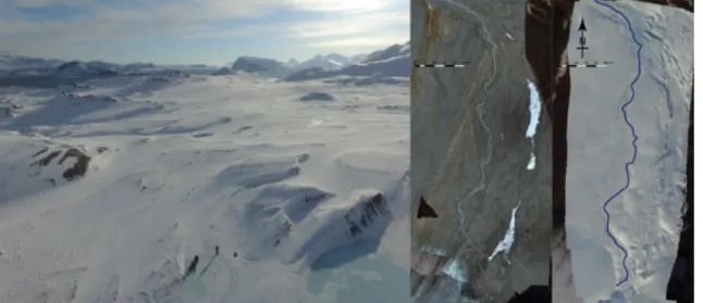
Figure 1: Oblique view of the study area and comparison of September (left) and April (right) stream channel result-ing from subglacial outflow (Austre Lovenbreen).
LiDAR – and in our case its terrestrial implementation – is currently the reference system for Digital Elevation Model generation: this highly specialized instrument provides utmost resolution with the draw-back, when considering extended terminal moraine areas, of excessive shadows avoided by bringing the instrument to elevated measurement positions, a feat not necessarily achievable in given weather condi-tions or geographic settings. We consider the complementary use of commercial, off The Shelf (COTS)
DJI Phantom3 Professional Unmanned Aerial Vehicle (UAV) for aerial photography acquisition, com-bined with Structure from Motion (SfM – using dedicated software as MicMac, IGN, Agisoft Photoscan and QGis) analysis, for DEM computation: DEM differences between datasets acquired in April (snow cover maximum and icings volume maximum) and September (snow cover minimum) yield a volume difference attributed either to snow cover or icings formation. Repeated measurements over a short period and moraine regions whose topography is known to be stable hint at an elevation resolution in the decime-ter range, well below the icings and snow accumulation in the medecime-ter range. While the vegetation-free moraine provides ideal conditions for SfM – with lateral resolution down to 5 cm/pixel when flying at an altitude of 100 m – snow and river ice covered areas are challenging for the feature matching step needed for SfM initialization. We observe that under appropriate lighting conditions, most significantly avoiding the long shadows associated with a low-lying sun and overcast conditions, well resolved DEMs are ac-quired and generate a useful dataset.
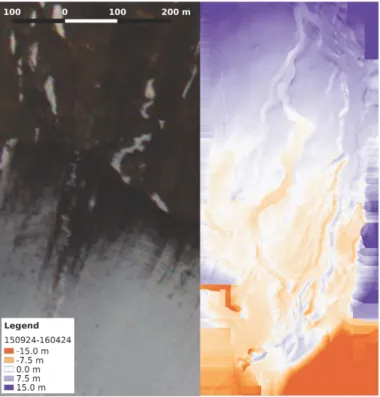
Figure 2: DEM difference between April and October acquisition. The result is mapped on a Formosat satellite im-age, which is used as a spatial reference.
This presentation shows early applications on snow accumulation over the moraine, and on icing volume estimation, which provides a significant water reservoir. In a next step, the goal is to compare water equivalent accumulation (W.Eq.) in the icing with constant outflows monitored on the outlet of the basin. Acknowledgements: French National Center for Research, Franche Comté region, IPEV, Photocoptère.
References
BERNARD,É.,FRIEDT,J.M.,TOLLE,F.,GRISELIN,M.,MARTIN,G.,LAFFLY,D.,&MARLIN C.,2013. Monitoring sea-sonal snow dynamics using ground based high-resolution photography (Austre Lovénbreen, Svalbard, 79°N). ISPRS
Journal of Photogrammetry and Remote Sensing, 75: 92-100
LUCIEER,A.,TURNER,D.,KING,D.H.,&ROBINSON,S.A.,2014.Using an Unmanned Aerial Vehicle (UAV) to capture micro-topography of Antarctic moss beds. International Journal of Applied Earth Observation and Geoinformation, 27: 53-62
WESTOBY, M.J.,BRASINGTON,J.,GLASSER,N.F.,HAMBREY,M.J., REYNOLDS J.M.,2012. ‘Structure-from-Motion’ photogrammetry: A low-cost, effective tool for geoscience applications. Geomorphology, 179: 300-314