Collective Space for M.IT. West Campus
By Donna Anne BarbaroB.A. Washington University, 1977
Submitted in Partial Fulfillment of the Requirements for the Degree of Master of Architecture at the Massachusetts Institute of Technology June 1981
@ Donna Anne Barbaro 1981
The Author hereby grants to M.I.T. permission to reproduce and to distribute copies of this thesis document in whole or in part.
Signature of the Author ... Department of Architecture. Mav 8, 1981
Certified by..., ...
Barry Zevin, Assistant Professor of 'chitecture Thesis Supervi-"
Accepted by..., ... .
Sandra Howell, Chairperson
Departmental Committee for Graduate Students
MASSAM,
MINSTITUTE
OF TECHN3LOGY
MITLibraries
Document Services Room 14-0551 77 Massachusetts Avenue Cambridge, MA 02139 Ph: 617.253.2800 Email: [email protected] http://Iibraries.mit.edu/docsDISCLAIMER OF QUALITY
Due to the condition of the original material, there are unavoidable flaws in this reproduction. We have made every effort possible to provide you with the best copy available. If you are dissatisfied with this product and find it unusable, please contact Document Services as soon as possible.
Thank you.
The images contained in this document are of
the best quality available.
ABSTRACT
COLLECTIVE SPACE FOR MIT WEST CAMPUS By Donna Anne Barbaro
Submitted to the Department of Architecture on May 15, 1981 in partial fulfillment of the requirements for the degree of Master of Architecture.
The vitality felt in proceed-ing through a marketplace or in walking through the streets of
some towns and cities can sen-sitize one to the particular potential a street can have as a place for informal conversa-tion, sitting, watching or
gathering collectively - an
al-ternative setting to the social atmosphere that exists within offices or classrooms. The
range of outdoor spaces that can be found are organized
accord-ing to principles which people have agreed upon formally or
informally over time. Streets with this level of definition
are easy to stay in, move ones' chair or wares out into or carry on 'with business' in. Although passage through is often its most important function, a
suc-cessful street also offers a clarity of territorial
defini-tion with 'eddies,' boundaries and backs that allow a range of other activities to occur.
In its best sense, one could feel that one is moving through a collection of outdoor rooms of various enclosure, each re-lated in some sense to both the public path and to the less
public spaces beyond.
On a university campus, where exposure and discourse are en-couraged, a collective backbone of this nature would be an asset, both as an outlet within the
university and as a way of tying the university to the surround-ing community.
The intention of this thesis is two-fold; first to explore street as place and "linkage" in the context of site and building edge; and second, to suggest alternatives for the MIT West Campus.
Thesis Supervisor: Barry Zevin
To all those who helped me keep things in perspective.
Table of Contents
ABSTRACT ... ACKNOWLEDGEMENTS. .. 3 .. 5 INTRODUCTION... Existing West Campus... Study Site... Program... DESIGN PROCESS... Initial Site Studies... Studies for the Student Building Components.... SCHEMATIC DESIGN PROPOSAL.Cente .. .10 .12 .13 .14 .16 .30 .34 ... .. . 44
ASPECTS OF THE STREET; PATTERNS.... 57
Introduction
The M.I.T. campus is
organ-ized primarily in the east-west
direction along double loaded
corridors. With few exceptions,
there are no opportunities for a person to reference verti-cally or horizontally in space.
The Charles River, a major
ref-erential resource running
para-llel to the corridor system, is
not utilized sufficiently as an orientation device from
within. Unless you're in Lobby Ten and able to see the Great Court and river, it is
very easy to become disoriented in your travels through the
corridor network. Vertical
referencing presents similar problems. There are few visi-ble vertical continuities along the corridors that make clear what's above and below you. Again, the lobbies of -buildings provide vertical relationships
lMain corridor through east campus in plan and section,
among floors but cases such as these are rare. In most instan-ces, movement through the hall-ways as they relate to the
whole building complex is not
spatially clear. One is either
in or outside.
Not only is the'volumetric
space' inadecuate in orienting
people as they move through, but so are the 'spatial edges', or wall zones along the
cor-ridors. The walls rarely be-come territorial; usable for
sitting in, putting displays
in, or for delineating an
en-trance,
EXISTING WEST CAMPUS
The path through West
Cam-pus is less disassociative but
this has more to do with the fact that so much of it is un-built rather than the result of a conscious effort to maintain
a three-dimensional order. Few
internal activities address the
'street' at ground level. Both the internal functions and the entrance to the existing
Strat-ton Student Center provide no
overlap with the street edge,
causing it to be a completely
internalized environment.
Kres-ge and the Chapel, both
inward-ly focusing buildings, are
dif-ficult to move up against. They provide no buffer of street
or-iented edge to back up to.
Buildings such as McCormick
Dormitory along Memorial Drive,
in their east-west orientation, cut off views to the Charles River.
Along Vassar Street to the north, buildings such as West Garage and the Metropolitan
Warehouse act as a
O O)
orO
llll
L~fl
L7
2 4 F- lkSTUDY SITE
For the purpose of this
ex-ploration several West Campus buildings have been removed. Those that remain are Ashdown, Bexley, Cavs, Dupont, the
Rockwell Cage and Baker House, with the Chapel and Kresge to be considered in later schemes.
The Charles River and the Athletic Field provide the
pri-mary spatial
references for the
West campus with the Rogers
5. Building and Massachusetts
Ave-nue playing a lesser role. At
all times in moving through
West campus one should be able associate with at least one of
these, either directly or
through an indirect reference. VISA At the heart of Piazza San
Marco in Venice, for instance, although you may not be able
to see the water, in knowing
tower to the water you can immediately understand your whereabouts.
Pedestrian movement through the site flows primarily toward the dormitories along Memorial Drive with fewer people moving toward West Garage and other activities along Vassar Street.
PROGRAM
The design proposal accono-dates those uses which have
been removed for the purpose of the exploration. These include primarily the activities of the
present student center, along with dormitories, medical
ser-vices, a gymnasium and services for the existing gymnasiums, Along with this, additional shops and dormitories are pro-vided for.
Design Process
j3/--_
Figure 8
The front yard is wasteful as a functioning extension of the street. It is not the outdoor extension of the inner private space that it pretends
to be. It is either public nor
pri-vate. It has many of the cualities of a wall; iirpemetrable, indicating
privacy. But this wall is laid out
horizontally - it beccms confusing
as a result. Campare this with the
ground level of the palazzos in
Florence, which in trying to portray
9 a similar message, make the edge
much clearer for everyone.
Figure 9
A clearly defined front yard,
Until 1962, a commercial strip existed along
Massachu-setts Avenue across and to the
north of the Rogers Builcding.
It was set back only enough to
pro-vide a fifteen foot sidewalk. Soon after it was removed, the existing student center was built much farther back from Massachusetts Avenue, leaving in between a large green space. This added to the progressive
breakdown into parking and
empty lots, and unclaimed green space of the street edge that extends approximately 300 yards
to the north along Massachu-setts Avenue,
Although rebuilding the
street edge in front of West Campus isn't enough to
re-establish the rythmn set up farther north along Massachu-setts Avenue, it begins to
S
Li
'4 ~t~W4 a *
I
Figure 10
establish clear territories. In the initial schemes the proposed building along Mass-chusetts Avenue is entered
along its west side in response to the interior 'campus'
shop-ping street. The Massachusetts
Avenue side provides visual access in and creates a back for the street, to sit along or to find protection from the wea-ther in waiting for a bus or taxi.
INITIAL SITE STUDIES
First Pass
Figure 11
The first pass at the site
shows buildings backing up to Vassar Streets' impenetrable
'wall', creating a more habit-able wall along the new edge.
Major pedestrian movement passes
along this wall which is shown in the diagram as a forest at
the base of a mountain.
Secon-dary movement passes between a larger and smaller mountain, through .a canyon-like space.
Figure 12
In a later study major move-ment continues along the
build-ing edges, with secondary ac-cess moving 'through a piece of the building. The large open green space gives pedestrians tine to see where they're about to go before having to turn.
Outward focusing activities such as shops, workshops and eating places occur along the
street and serve to buffer and connect inward focusing cells
such as gymnasiums,
auditori-ums and chapels. Access to activities on the second level occurs along the outdoor street aswell.
This scheme blocks visual access to the playing fields and makes a public space within one of the buildings that is
orien-ted away from the street.
In order for a public square to work, the focus of all of these
buildings must be oriented toward
it. People gravitate naturally
of activity: shops, stands,
benches, displays, rails, courts, gardens, news racks. These pock-ets should all be next to paths and entrances so that people pass right by them as they pass through. The goal-oriented activity of coming and going then has a chance to turn grad-ually into something more relaxed. And once many small groups form around the edge, it is likely that they will begin to overlap and spill in toward the center of the square.
toward the edge of public spaces. They do not linger out in the open. If the edge does not pro-vide them with places where it
is natural to linger, the space becomes a place to walk through,
not a place to stop. It is
there-fore clear that a public square should be surrounded by pockets
F igure 12
Second Pass
Here, ground level
activi-ties begin to focus on the
street as the collective space. Although a view through to the
playing fields is possible, visual access to the river is now blocked.
I -I
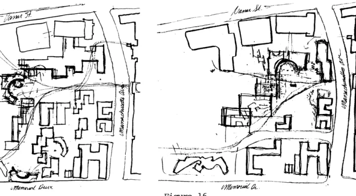
Third Pass
Figures 14-16
In each of the following cases collective pockets are introduced as a way of making a turn in the path. They end one of the two directions and serve as a secondary focus in the journey through. They are bypassed by circulation and therefore have placemaking potential,
7fr9iw~4eV ~2tU~
Figure 16 Figure 15
17
Fourth Pass
Figures 17-18
In the previous studies,
the buildings weren't clearly
responding to the major site
references. The block studies clarify two major site
direc-tions. The buildings to the
north run in the east-west direction. As the most public buildings on the site they maintain maximum contact with the public edge as their long dimension occurs along the public street. This direction
also reinforces the connection
with the playing fields.Since
buildings to the north of this
act as a wall to any further growth in that direction, and
since they contain and respond to inward focusing activities
(gymnasium and warehouse), the new buildings act to create an active buffer between them and
the pedestrian street.
The buildings to the south side of campus are oriented in the north-south direction. Their direction allows visual and phy-sical access to the river. They tend to be less public in
charac-ter, with some shops and
work-shops at the ground level and residences above. In moving
along the main street, one passes
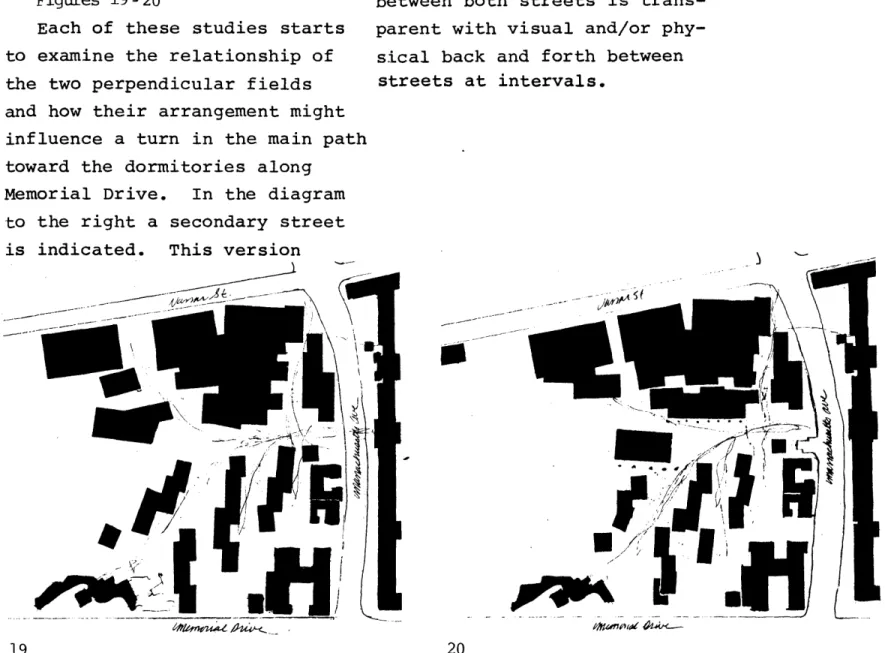
Figure Ground Studies
Figures 19-20
Each of these studies starts to examine the relationship of the two perpendicular fields and how their arrangement might influence a turn in the main path
toward the dormitories along
Memorial Drive. In the diagram
to the right a secondary street is indicated. This version
could only work if the piece between both streets is trans-parent with visual and/or
phy-sical back and forth between streets at intervals.
Fifth Pass
This series of sketches
ex-plores alternatives for
organ-izing the site, this time
in-corporating both Kresge and the Chapel. These forms are
helpful in making a change of
STUDIES FOR THE STUDENT CENTER
In each of these
explora-tions, shops occur along the
outside perimeter of the building at street level.
A- shops B- Cocp C- storage D- delivery
o
, e. ,. Figure 28. The building is arranged
orthagonally with the Coop occupying the center and
smal-ler shops along the street. Access to each shop is from the street and to the second level from outside stairs on the east side of the building. Truck delivery occurs along
the north side.
2F
Figures 29-30
. An attempt at giving the
shops their own identity.
Figure 31
. Both stores now have direct
access to storage and truck delivery. Entrance to Coop now along main street.
29
[A}
xI
44
it
--4
Figure 32
Typical shop with access from the street.
Figure 33
Building interior acknowledges second site direction.
'U
BUILDING COMPCHJPS
fl
C)l
0
16'
32'
38
0
16'
Figures 42 -44
Study model of a piece of the student center.
42
44
Figures 45-47
The following diagrams are a systematic pass exploring some
of the edge zones that are cre-ated by moving the enclosure
relative to ground and
struc-ture. Relationships are
ex-plored at 1' 6", sitting height;
3' , a height one can view over while sitting; and 6'8"+, a
height that blocks views.
L4LA;,
1 i4
1L
45-47
46 tL
Schematic Design Proposal
Fiqure 48
Site Plan F igure 4 9
Plan of main street.
Figure 50
Plan of main street. Figure 51
North elevation along street. Figure 52
Section through street, Figure 53
Section through outdoor steps leading to second level,
w~ Ct l
Or
i- =OI =W|11 T7. _TT * 'j' I 4 I LII Amm, 1
-,,t', '2.4 "U It', 7 3 1Z.L II II II II II II Ar) *mo
C0
Aspects of the Street; Patterns.
Following are suggestions,
with examples that should be
taken into account when design-ing the street framework.
1.
If indoor staircases, corri-dors and lobbies are eliminated so that most of the circulation occurs outdoors, or is perhaps directly a.ssociated with the outside edge of the building,
5
then this will help to generate an active pedestrian street. Entrances to small and large shops, workshops and eating places as well as access to the upper levels, should occur dir-ectly from the street.
Li.
Major site landmarks that
can be associated with either
directly or indirectly when
moving along a street, help to
make clear a person's
where-abouts in space. For instance,
if the street is perceived as
part of a coherent succession of spaces, textures and/or ob-jects that together comprise a
greater whole, ard if this whole
has a clear relationship to a landmark, this provides an in-direct association.
A landmark is strongest if
"visible over an extended range of time or distance and more
useful if the direction or view
can be distinguished. If iden-tifiable from near or far while moving rapidly or slowly, by night or day, it then becomes
a stable anchor for the percep-tion of the complex and
shift-ing urban world."
,
jrT
Fiaure 57
The Duomo in Florence "is a prime example of a distant landmark: un-mistakable; daminant by size and
contour; paired with a campanile
in such a way that the direction of view can be gauged from a distance".
Figure 58-59
Although the water isn't visible from all parts of Piazza S. Marco, the tower, in its clear relationshiD
3.
Inward focusing cells
shouldn't occur along the street. They should either be separated
by distance or buffered with
ac-tivities that maintain a more
tosymbiotic relationship with the
set a f th te edge\\\~ street.
\Nor
-REAL\N.j
I
0
if an iwrfoungcell is
to occur along the outside
peni-n -eter of a building, it should be \\
set aart frmn the street edge. \, "\ \1 . ..
Main building, Otaniemi. Alvar
Aalto.
Figure 61
Krescp neets the street only at
There are two basic use types that occur throughout the West
campus. The inward focusing
cells, both large and small, such
as auditoriums, chapels and
gym-nasiums; and the outward or street
/- ..
* Lqp
O 0
Figure 62
The auditorium in Herman Hertzberger's
Music Hall in Utrecht, Netherlands is surrounded by shops at 'street' level.
oriented cells such as restau-rants, shops, offices, workshops and certain zones of the residen-ces.
Figure 63
Vendors in Florence back their wares
up against a wall of the Church of
San Lorenzo, creating an active street edge.
4.
The distance between
build-ings should be a function of height and the need to get sun
down to street level. In most cases movement through a street requires only a portion of this full width. The width needed for movement should be defined.
A reference for determining
path width through west campus is in the main corridors of the east campus where the volume of
people moving through the 9'9"
corridors at any one time ap-proximates the traffic that can be expected to move through west campus. Along streets that require access for
emer-gency vehicles, clearance of
A - t - rmte . tts
Figure 65
Street width is clearly
de-f ined in Pembroke College
Dorm-itories by MLTW.
5.
There are many ways for stores, workshops and eating places to establish a connec-tion with the street so that entering is continuous with the public path.
A - If the edge zone is made
predominantly of glass, this allows views in.
B - A more engaging connection
occurs when the physical edge
z-one is essentially open to the
street. With sliding panels, shutters or garage doors, that provide protection when needed, sounds and smells are introduced as well as the ability to con-verse across territories.
C - If the edge zone is not only
physically open but if some of the activity can move out and cross the street, then it is no
longer a matter of moving along-side but actually through the
activities.
In order for it to maintain such a relationship, the street should be treated as a success-ion of outdoor rooms. These would be partly enclosed spaces, with enough of the qualities of a room to permit people to act as they do in rooms.
To make such outdoor 'rooms', low walls, trees, level changes and paving must in themselves or together form containers for
sitting in or "backing up" to. To make these outdoor rooms public, "the path to the
build-ing must itself become a 'place'
that is partly inside the
build-ing and this place must contain the character of the inside."
If the ground, edges, curbs, walls or overhangs that define
the building can get out and also define some of the street
shop 'seats shop V oods shop isplay pedestrian path 68
Figure 69
A visual connection is made
with the street. * Figure 70
The edge is open to the street and one moves alongside the activity.
Figure 71
The edge is open and some of the activity straddles the path
so that one is moving through
the store,
69
(or vice versa) then access will not be abrupt; the sense of
en-tering will seem very much a part of the street,
"To establish this place as
a territory which is also apart from the public world, it must be felt as an extension of the
Figure73
The curb that defines this street extends into the
build-ing and defines part of the lobby.
Figure74
One bench provides a buffer from the 'street' and makes a more defined place for the bench behind it.
Figure75
An outdoor room along the 'street'.
Figures 78 - 80
Outdoor rocms can be reinforced with display walls, places where the personality of a shop can get outside.
.. ... ..._T
6.
Building corners, for certain
uses, should be transparent at least at eye level along streets. This helps to make the turn more
spatial. It provides a clue as
to where you're going and alle-viates collisions that may occur
between two people coming from different directions around that
corner. The more major the turn
the more time should be
avail-able between seeing the turn and having time to decide whether or
not to make it. In these cases,
a larger region of the building
7.
When a major path branches off into two or more paths, con-tinuity of direction, dimension, level and/or materials should be maintained between the initial main path and the main branching path. Secondary branching paths ,will have more clarity with a
break in continuity. Attention is usually focused at points of decision. Therefore, the end of the initial path should be marked with a form that serves both as a focus and as an introduction to the other direction. It pro-vides something to move around, similar to the way that a jutting rock interrupts the flow of a river.
016
88
In order for an outdoor
room to successfully operate as a place, circulation must move
around and not through it, For
example, activity pockets, focus
points at path intersections or
branches, thrive when they don't block the shortest distance
be-tween two paths but occur just beyond.
95
9.
Privacies off of public
streets can be indicated with
change in material, direction,
relative size and/or level
changes.
F igure 97
Although access to these step
steps maintains the public
di-rectiontheir height and width
in comparison to the public
street suggest a more private
domain.
Figure 79
There are two level changes,
The first step can be accessed
while moving in the public
di-rection. Access to the second
step is perpendicular to the street access, This and its contrasting relationship to
'street-size' steps makes it a
more private gesture.
Figure99
The change in direction and
dimension are factors in in-dicating the private territory.
Figure 100
The stoop that is accessed parallel to the public
di-97 rection is more public than
Bibliography
Alexander, Christopher; Ishikawa, Sara; and Silverstein, Murray. A Pattern Language. N.Y.: Oxford University Press, 1977.
Anderson, Stanford, ed.. On Streets. Cambridge, Ma.: MIT Press, 1978.
Brambilla, Roberta; Longo, Gianni. For Pedestrians Only. N.Y., Watson-Guptill Publi-cations, 1977.
"Buildings Designed as 'Street.'" Architectural Record. July-September 1968.
Cruikshank, Jeffrey, ed.. "Processes in Architecture: A Documentation of Six Examples," Plan. Cambridge, Ma., School of Architecture and Planning and the Committee on the Visual Arts, 1979, pp. 75-94.
Cullen, Gordon. The Concise Townscape. N.Y.: Van Nostrand Reinhold Company, 1961. Dueker, Taylor True. "Decoration/Intensification/Collage as Definition/Form in
Build-ing...A Built-Form Exploration." M. Arch Thesis, MIT, September 1977. Goldfinger, Myron, "Repetitive Forms," Architectural Forum, March 1966.
Gruzen and Partners, Mitchell and Giurgola, MIT East Campus Planners and Architects. East Campus Master Plan. Cambridge Ma., Wintry Press.
Gutheim, Frederick, ed.. In the Cause of Architecture. Frank Lloyd Wright. N.Y., N.Y., McGraw-Hill, 1975.
Jones, Peter Blundell. "Hans Scharoun." Monograph. London, G. Fraser, 1978. Jordy, William H. "Making the Ordinary Extraordinary." Progressive Architecture,
January-March 1976, pp. 47-53.
Kahler, Heinz. Hadrian Und Seine Villa Bei Tivoli. Berlin, Gebr. Mann, 1950. Lynch, Kevin. The Image of the City. Cambridge, Ma., MIT Press, 1962.
Lynch, Kevin. Site Planning. Cambridge, Ma., MIT Press, 1960.
"MLTW/Moore, Lyndon, Turnbull." Progressive Architecture. January-March 1970, pp. 130-135.
Michaelides, Constantine E.. Hydra: A Greek Island Town. Cambridge, Ma., MIT Press, 1962.
Papadakis, Dr. Andreas. "Alvar Aalto." Monographs 4. N.Y., NJ., Rizzoli Interna-tional Publications, Inc., 1978.
Rudofsky, Bernard. Behind the Picture Window. N.Y., Oxford Oniversity Press, 1955. Rudofsky, Bernard. Streets for People; a Primer for Americans. Garden City, N.Y.,
Doubleday, 1969.
Santini, Pier Carlo, ed.. "Un opera di Carlo Scarpa iil restauro di una antico
palazzo veneziano." Zodiac 13. Ivrea, Italy, Ing. C. Olivetti and Co., 1964,
pp. 26-59.