HAL Id: ird-02381096
https://hal.ird.fr/ird-02381096
Submitted on 8 Jan 2021
HAL is a multi-disciplinary open access
archive for the deposit and dissemination of
sci-entific research documents, whether they are
pub-lished or not. The documents may come from
teaching and research institutions in France or
abroad, or from public or private research centers.
L’archive ouverte pluridisciplinaire HAL, est
destinée au dépôt et à la diffusion de documents
scientifiques de niveau recherche, publiés ou non,
émanant des établissements d’enseignement et de
recherche français ou étrangers, des laboratoires
publics ou privés.
Distributed under a Creative Commons Attribution - NonCommercial| 4.0 International
Rain-fed agriculture thrived despite climate degradation
in the pre-Hispanic arid Andes
Pablo Cruz, Thierry Winkel, Marie-Pierre Ledru, Cyril Bernard, Nancy Egan,
Didier Swingedouw, Richard Joffre
To cite this version:
Pablo Cruz, Thierry Winkel, Marie-Pierre Ledru, Cyril Bernard, Nancy Egan, et al.. Rain-fed
agri-culture thrived despite climate degradation in the pre-Hispanic arid Andes. Science Advances ,
Amer-ican Association for the Advancement of Science (AAAS), 2017, 3 (12), pp.e1701740.
�10.1126/sci-adv.1701740�. �ird-02381096�
A N T H R O P O L O G Y Copyright © 2017 The Authors, some rights reserved; exclusive licensee American Association for the Advancement of Science. No claim to original U.S. Government Works. Distributed under a Creative Commons Attribution NonCommercial License 4.0 (CC BY-NC).
Rain-fed agriculture thrived despite climate degradation
in the pre-Hispanic arid Andes
Pablo Cruz,1Thierry Winkel,2* Marie-Pierre Ledru,3Cyril Bernard,4Nancy Egan,5,6 Didier Swingedouw,7Richard Joffre4
Archaeological research suggests significant human occupation in the arid Andean highlands during the 13th to 15th centuries, whereas paleoclimatic studies reveal prolonged drier and colder conditions during that period. Which subsistence strategy supported local societies in this harsh environment? Our field and aerial surveys of ar-chaeological dwelling sites, granaries, and croplands provide the first evidence of extended pre-Hispanic agriculture supporting dense human populations in the arid Andes of Bolivia. This unique agricultural system associated with quinoa cultivation was unirrigated, consisting of simple yet extensive landscape modifications. It relied on highly specific environmental knowledge and a set of water-saving practices, including microterracing and biennial fallow-ing. This intense agricultural activity developed during a period of unfavorable climatic change on a regional and global scale, illustrative of efficient adaptive strategies to cope with this climatic change.
INTRODUCTION
The adaptation of human populations to extreme environments has been the subject of numerous studies in cultural ecology and environmental anthropology, notably in the Andes where human occupation is ancient but also vulnerable because of the highly variable, often stark, mountain environment (1, 2). Whether environment or man was the main deter-minant of the shifts in human-nature relationships reported in the Andes remains controversial, even in the case of the indisputable agrarian col-lapses that occurred in the region (3–8). The controversy is partly resolved by Contreras’ suggestion that we consider the Andean highlands to be a mosaic of structuring, modified, and sacred environments, with struc-turing milieus shaped by environmental factors, whereas anthropogenic changes associated with subsistence activities dominate in modified landscapes, and ritual or ideological dimensions do so in sacred places (2). The notion of modified landscape is crucial for a correct apprecia-tion of human-environment interacapprecia-tions because, besides settlement sites and monumental architecture, it also considers agricultural fields and modest infrastructures such as paths, walls, terraces, or corrals (9). Consistency of observation is another requisite for analyzing changes in human-environment interactions, especially when linking archaeological and environmental records of distinct spatial and temporal scales (10). That extreme environments may spur extensive landscape modification by local populations, rather than simply forcing behavioral adaptation such as seasonal nomadism, is a stimulating proposal that can be traced back—as regards the Andes—to Troll’s work (11). However, this hypoth-esis still awaits substantiation, particularly concerning the social organi-zation, environmental knowledge, and robust adaptive techniques required of past societies facing harsh mountain environments.
The Andean altiplano, a wide highland plateau located between 3500 and 4500 m above sea level, extends from southern Peru, through Bolivia, and into northern Chile and Argentina (Fig. 1). The region is far from homogeneous, showing a gradient of increasing aridity and cold from the temperate shores of Lake Titicaca in the north to the cold deserts of the arid Andes in the south (12, 13). In this highland environment, climatic fluctuations have been documented through-out the late Holocene showing centennial and multidecadal time scale changes (14), to which interannual variations driven by El Niño– Southern Oscillation and the Pacific sea surface temperature anomalies are superimposed (12).
Yet, the perception of this highland environment as marginal for human settlement is challenged by many archaeological studies doc-umenting intense human occupation and landscape modification long before historical times (14). In the northern altiplano, numerous agrarian societies developed from 1500 BCE (Before the Common era): Chiripa (1500–0 BCE), Pucara [0−300 CE (Common era)], Wari (550−1000CE), Tiwanaku (500−1100 CE), the societies known as Aymara Chiefdoms (1200−1450 CE), and finally the Inkas (1450−1535 CE), be-fore the arrival of the Spanish. Landscape modifications by these pre-Hispanic societies often took the form of large irrigated or drained terrace systems (14–17).
In the southern altiplano, evidence of pre-Hispanic agrarian societies is less frequent and more recent, principally related to the Late Regional Development Period (LRDP, 1200−1450 CE) and the Late or Inka Period (1450−1535 CE) (18–20), with the period before 1200 CE considered to be a long transition from mobile hunting-gathering and herding commu-nities to more aggregated and proliferating agropastoral settlements (21, 22). Research on ancient agriculture in this arid and cold region has also focused on irrigated systems (23, 24). Yet, the limited extension of these irrigated systems suggests marginal crop production in a region essentially devoted to camelid herding (23, 25). Here, we present the first evidence of extended rain-fed agricultural systems supporting signifi-cant human populations in the pre-Hispanic arid southern Andes.
RESULTS
Archaeological dwelling sites and granaries
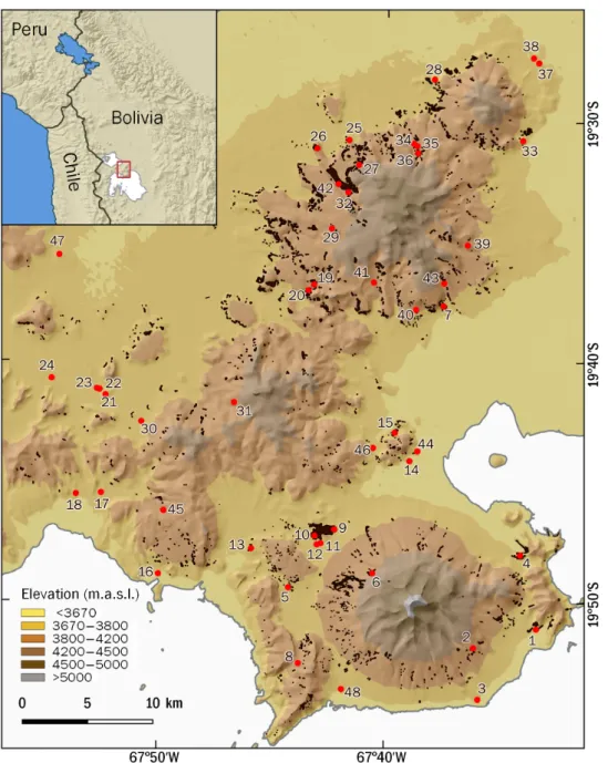
Our study area (60 × 40 km) is located in a region known as the In-tersalar, situated between the salt flats of Coipasa and Uyuni in the
1
UE CISOR (Unidad Ejecutora en Ciencias Sociales Regionales y Humanidades), CONICET (Consejo Nacional de Investigaciones Científicas y Técnicas), Universidad Nacional de Jujuy, San Salvador de Jujuy, Argentina.2CEFE (Centre d’Écologie
Fonctionnelle et Évolutive), IRD (Institut de Recherche pour le Développement), CNRS, Université de Montpellier, UPVM3 (Université Paul-Valéry Montpellier III), EPHE (École Pratique des Hautes Études), Montpellier, France.3ISEM (Institut des
Sciences de l’Évolution de Montpellier), IRD, Université de Montpellier, CNRS, EPHE, CIRAD (Centre de Coopération Internationale en Recherche Agronomique pour le Développement), INRAP (Institut National de Recherches Archéologiques Préven-tives), Montpellier, France.4CEFE, CNRS, Université de Montpellier, UPVM3, EPHE,
IRD, Montpellier, France.5IIT (Instituto Interdisciplinario Tilcara), Universidad de Buenos Aires, Tilcara, Argentina.6History Department, University of California San Diego, La
Jolla, CA 92093, USA.7EPOC (Environnements et Paléoenvironnements Océaniques
et Continentaux), CNRS, Université de Bordeaux, EPHE, Bordeaux, France. *Corresponding author. Email: thierry.winkel@ird.fr
on January 8, 2021
http://advances.sciencemag.org/
southern altiplano of Bolivia (Fig. 1). Today, the region is the world’s leading center of quinoa production (26). Embracing the entire Inter-salar area, Lecoq’s pioneering work (20) revealed a significant human occupation during the LRDP, evidenced by the proliferation of agglom-erated dwelling sites (Fig. 2A).
We identified 48 LRDP sites of variable areal extent in the study area (48%, <1 ha; 27%, 1 to 2 ha; 21%, 2 to 3 ha; 4%, >3 ha), mostly (77%) between 3650 and 3800 m in altitude (16% between 3800 and 4000 m; 7% between 4000 and 4250 m) (Fig. 1 and table S1). The density of these pre-Hispanic dwelling sites, fairly evenly distributed in the study area, is close to that of the present-day 52 rural communities.
The chronological adscription of these sites to the LRDP is based on the coherence between the mode of establishment, the architecture, and the material culture, mainly the styles of ceramic sherds. These elevated
settlements, with high visibility and defenses in some cases, are generally referred to in archaeological literature as pucaras and are considered one of the principal indicators of the LRDP (27, 28). In all of the sites in our study, the principal ceramic styles found are equally distinctive of this period (20, 29–31). The Intersalar ceramic style (also known as Quillacas) predominated, whereas the Mallku, Puqui Tricolor, Yura, and Huruquilla styles appeared less frequently (fig. S1). At the sites where we have concentrated our studies, this chronology has been con-firmed by 16 radiocarbon dates (1200–1450 CE; table S2 and fig. S2). In accordance with Lecoq (32), the material evidence at the sites studied shows an intense occupation of the region throughout the LRDP, which then progressively declines during the Late or Inka Period. Except in two sites on the flat plains (sites 1 and 48), no ceramics or signs of material culture from the Late Period were found in our study sites,
Fig. 1. Localization of 48 archaeological sites (red dots) identified in the study area. Black dots show archaeological croplands identified by field and aerial surveys. Numbers refer to identification numbers in table S1. m.a.s.l., meters above sea level.
S C I E N C E A D V A N C E S |
R E S E A R C H A R T I C L E
on January 8, 2021
http://advances.sciencemag.org/
which thus show strong chronological consistency with the LRDP. A most probable cause of the depopulation of the pucaras in the second half of the 15th century was the southward expansion of the Inkas, who, as reported in Colonial Era documentary sources, displaced large popu-lations to agricultural activities in the nearby Andean valleys and to mining centers (33, 34).
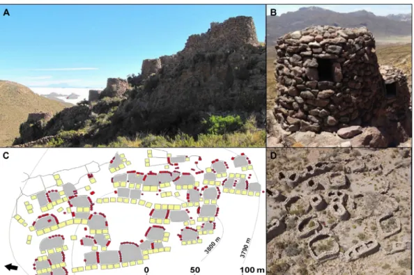
All sites are made up of a variable number (between 10 and 68) of well-defined dwelling and storage units, each structured around an open space (patio). The extension of the patios (60 to 200 m2), the num-ber of habitational enclosures (two to four), and the numnum-ber of granaries (two to eight) vary from one site to another (Fig. 2, C and D, and fig. S3). In most cases, the units are delimited by groups of contiguous granaries. At each site, the dwelling units are articulated organically by a network of paths. In some cases (sites 5, 7, 9, and 17), we identified large open spaces or plazas but have not identified hierarchized constructions, structures, or centralized spaces of power, such as large houses, plat-forms, or religious buildings. In all of the sites, numerous and large corrals were also observed, evidence of the combined crop-growing and livestock-rearing strategy used by local populations.
The granaries identified have rectangular, square, or oval bases and may have both roof-like coverings and an access window or lack both roof and window (fig. S4). The excavation of four granaries at Jirira Vinto revealed that they were used for the storage of quinoa grain, like the granaries in Lípez. These quinoa grains were dated 1324–1440 (95% cal CE) (table S2). Similar dates were obtained for archaeological quinoa seeds collected from five pre-Hispanic granaries and deposits in the Lípez, 70 to 100 km south of the Intersalar region (35).
The location and the structure of these granaries differentiate them from pirwas—the deposits that stored potatoes—which are located in fields and have a circular base, a roof, and an access door. In the whole study area, 4652 granaries have been identified to date, with an
indi-vidual capacity ranging from 2 to 6 m3(fig. S4 and table S3). This number represents a minimum count that excludes those granaries impossible to identify with certainty or that have been destroyed. At various sites (1, 3, 4, 5, 6, 8, 10, 13, 15, 17, and 32), we observed that contiguous granaries were built from one initial structure, a pro-cess suggestive of a progressive increase in agricultural production and storage capacity.
Archaeological croplands
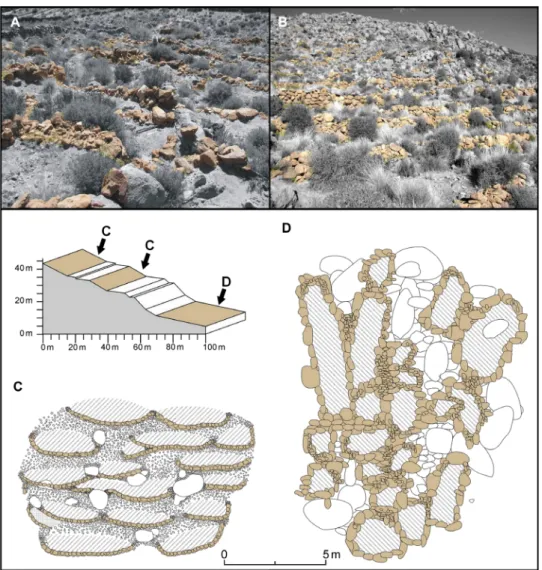
In accordance with this high grain storage capacity, we observed a spe-cific agricultural technology consisting of a multiplicity of croplands, re-vealed by archaeological stone alignments and reflecting an intense past agricultural activity (Fig. 3, A and B). The typology of the identified crop-lands principally reveals microterraces and small crop beds (canteros) that make up 1- to 10-m2crop areas that we call“minimal surfaces of production” (hereafter MiSP) (Fig. 3, C and D) (36). The MiSP densely occupy favorable sites on the slopes and, like any other terracing struc-ture, make them fit for cultivation by slowing down surface water runoff, thus improving water infiltration and reducing soil erosion (37). Their construction did not require much labor; they often consist of only a few aligned stones. Linear terraces that require a greater investment of labor were rarely observed in the Intersalar region. In areas with gentle slopes (typically <5°), these MiSP were combined with sloping terraces and broad fields, either found in groups or isolated (Fig. 4).
From 2007 to 2016, field prospections and additional analyses of high-resolution satellite images identified 1537 ha of archaeological cropland in the study area (Fig. 1). This estimation is minimal because it excludes ancient fields overlaid by modern crops or for other reasons difficult to identify. Our observations showed that 95% of these archae-ological croplands lacked any irrigation structure, with only 5% of them presenting remains of possible canals or reservoirs. These croplands
Fig. 2. Archaeological dwelling sites in the study area. (A) General view of Incali (site 8, Fig. 1) with the salt flat of Uyuni in the background (Photo Credit: R.J., CNRS). (B) Circular granary with preserved rooftop at Charali (site 6, Fig. 1) (Photo Credit: P.C., CONICET). (C) Plan of Loma Bajala (site 5, Fig. 1) (red, granary; yellow, one-room house; gray, patio; arrow indicates north). (D). Aerial view of Incali (Photo Credit: Bruno Roux, L’Avion Jaune).
on January 8, 2021
http://advances.sciencemag.org/
reach an elevation of up to 4537 m, with 96% of them located between 3700 and 4250 m on slopes between 4° and 30°, and 66% of them ori-ented from the SSW to the NW (clockwise, fig. S5). Studies of current topoclimatic conditions in this area show that, because of cold air drain-age, frost risks are reduced at these locations (38).
Additionally, we observed that flat areas in the middle of the slopes, prone to cold air stagnation at night, remained free of any land modi-fication such as stone clearing or wall enclosure, suggesting the lack of cropping activity in these flat areas. Local populations thus seem to have known the agroclimatic risks related to slope position and topography. Archaeological evidence of different types of extended croplands dem-onstrates the ability of pre-Hispanic populations to condition significant land areas for rain-fed agriculture, using local topoclimatic knowledge and simple land management techniques to minimize the environmental risks of soil erosion and climatic adversities.
Coping with climatic limitations
In parallel with the physical layout of cropland, crop production de-pends on the implementation of a set of adapted agricultural practices. Considering that past climatic limitations in the study area were similar
to or worse than present ones (see below), and that agricultural practices in the whole Andean area have remained largely unchanged over time, our observations of current agricultural practices provide a framework to infer ancient ones. Today, in the Intersalar region, diverse crop man-agement practices are used to cope with major climatic limitations, espe-cially the scarce annual rainfall (<350 mm) that does not cover the water requirements of a complete quinoa crop cycle. In these conditions, the required amount of water can be obtained by concentrating water re-sources either in space or in time. For concentration in space, irrigation increases crop water availability over reduced areas via impluvia, spring capture, and canals. Notably, these systems are not found over significant areas in the Intersalar region. For concentration in time, biennial fallowing may allow accumulation of water resources over 2 years, as shown in var-ious dry farming areas in the world (39, 40). Biennial fallowing is practiced in the totality of quinoa cultivation in this region of the southern altiplano today. More than just controlling weeds and preserving soil fertility as in the temperate northern altiplano of Bolivia (41), biennial fallows in the arid southern altiplano serve to save water (section S2). The lack of archae-ological irrigation infrastructure in the Intersalar region leads us to as-sume that this biennial fallowing practice was already part of the local
Fig. 3. Ancient MiSP. (A and B) Views of ancient MiSP at Charali (site 6, Fig. 1), with stone alignments highlighted (Photo Credit: R.J., CNRS). (C) Sketch of archaeological microterraces found on relatively steep slopes (5° to 30°). (D) Sketch of archaeological crop beds (canteros) found on gentle slopes (<5°). Hatched areas in (C) and (D) show cultivated land surfaces, and colored areas show stone alignments.
S C I E N C E A D V A N C E S |
R E S E A R C H A R T I C L E
on January 8, 2021
http://advances.sciencemag.org/
agricultural knowledge during the LRDP. Its productive efficiency could have been high since, today, under similar conditions of hand cultivation on slopes in this same area (fig. S6), we have measured quinoa yields in peasants’ fields ranging from 1000 to 1500 kg ha−1 (section S2).
A prolonged dry and cold climate event
Paleoclimatic data of the Central Andes concentrate in northern Bolivia and southern Peru. Before our period of study, between ~500 and ~1100 CE, the Tiwanaku civilization benefited from wet climatic conditions to develop intensive and specialized agricultural practices around Lake Titicaca (42) (Fig. 5A). A dry period started after 1200 CE and lasted until 1400 CE as evidenced by lower levels at Lake Titicaca (43). Pollen analyses associated to archeological observations in Marcacocha attest to sustained aridity between 880 and 1400 CE (44), and the pres-ence of a dust layer in the Quelccaya ice core suggests a drier event dur-ing the 14th century (45). Measurements on moraines of the Charquini glacier characterized a dry period between 1360 and 1600 CE (46). In the southern altiplano, high-resolution tree-ring chronologies show de-creased precipitation rates between 1300 and 1400 CE with short hu-mid periods between 1300–1307 and 1322–1325 CE (47) (Fig. 5A and section S3). Over the entire period considered in Fig. 5A, dry and wet alternating periods are not synchronized over the whole of the altiplano. This situation is also reflected in the current period with discordance in precipitation anomalies between the north and south of the alti-plano (48). However, over the period 1200–1450 CE, all climatic proxies agree and characterize a dry period. Within this drier time interval, the rise of rain-fed agriculture in the southern altiplano coincided with a catastrophic volcanic event, the eruption of the Samalas Volcano in Indonesia (1257 CE), that initiated climatic changes lasting several dec-ades with drops in temperature and precipitation at a global scale (49). Moreover, a second major volcanic event, the eruption of the Quilotoa Volcano in Ecuador (1280 CE) (50), compounded and probably pro-longed the impact of the Samalas eruption on Andean climate and so-cieties. Simulations from the Paleoclimate Modeling Intercomparison Project Phase 3 (PMIP3) show that, after these two volcanic events, drying and cooling of the climate during the austral summer occurred in the study area, with a precipitation deficit of ca. 0.08 mm/day and a temperature decrease of between 0.2° and 0.3°C relative to the period 1000–1100 CE (Fig. 5B and fig. S7).
DISCUSSION
Our findings of extended archaeological croplands and numerous gra-naries dated to the LRDP (1200–1450 CE) suggest that the drier and colder climate conditions during that period did not impede—and in-deed might have triggered—the development of extended rain-fed ag-riculture in the Intersalar region. This agricultural development appears to have been based on both the intimate awareness of local landscape and climatic limitations (Contreras’ “structuring environment”) and a set of simple yet efficient land management techniques (Contreras’ “modified environment”) (2). Thus, a highly specific environmental knowledge combined with simple adaptive landscape modifications enabled local societies to thrive in a harsh highland environment despite more severe climatic conditions. The location, size, and form of these ancient cropland areas were oriented toward both the avoidance of frost risks and the conservation of scarce water and soil resources. Current practices of hand cultivation on slopes well reflect those that we found in the ancient agricultural landscapes of the southern altiplano
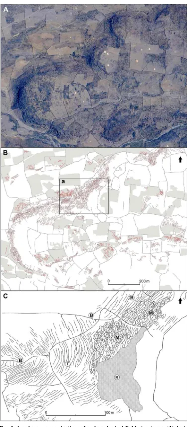
Fig. 4. Landscape organization of archaeological field structures. (A) Aerial view of the site of Charali (site 6, Fig. 1). (B) Sketch of the general distribution of archaeological field structures (red lines) over the site (gray lines and areas show today’s stone fences and cultivated areas). (C) Detail of inset (a) showing identified archaeological lineaments (B, broad fields; M, microterraces; R, rocky outcrop; T, sloping terraces).
on January 8, 2021
http://advances.sciencemag.org/
with its multiplicity of small cropland units. These practices, very much akin to gardening, are consistent with the Andean view of grain yield as the product of individual plant entities rather than the output of an undifferentiated grain field (1, 51). They also support new models of landscape history that promote bottom-up approaches of less visible landscape signatures to better understand Andean agrar-ian history (9, 52).
Furthermore, the elevated number of granaries present at each site identified in the study area indicates an agricultural economy capable of producing important productive surpluses. The abundance of granaries reflects ecological, practical, and social dimensions and can be con-nected to strategies of risk reduction to cope with climate variability, the need to face periods of social stress, the development of exchange practices, and expression of prestige and social memory (53–59).
Fig. 5. Regional paleoclimate variability. (A) Synthetic diagram showing the climatic variability during the past 1500 years in southern Peru and Bolivia based on the current available data from the Quelccaya ice cap (13°56′S, 70°50′W, 5470 m) (45), Lake Marcacocha (13°13′S, 72°12′W, 3355 m) (44), Lake Titicaca (16°S to 17°S, 69°W, 3804 m) (43), Mount Sajama (18°06′S, 68°53′W, 6542 m) (86), tree rings (seven records: 18°S to 22°S, 66°W to 69°W, 4300 to 4550 m) (47), Atacama Desert (~21°S, 69°W, 1300 m) (87), and the human occupation with the Wari (550–1000 CE), the Tiwanaku (500–1100 CE), the Regional Development Period (1120–1450 CE), and the Inkas (1450–1535 CE), highlighting the time interval 1200–1450 CE (gray area) and the date of two major volcanic eruptions (Samalas, 1257 CE and Quilotoa, 1270 CE) (red bars). (B) Anomalies in austral summer precipitation [December, January, and February (DJF), in millimeters per day] in the study area (green star) after the Samalas and Quilotoa volcanic events, showing a precipitation deficit of ca. 0.08 mm/day in the period 1200–1300 CE relative to the period 1000–1100 CE. Data are from four distinct climate model simulations (see Materials and Methods and table S4), with black circles showing the grid points where at least three simulations agree on the sign of the precipitation anomaly. Associated changes in surface temperature are shown in fig. S7.
S C I E N C E A D V A N C E S |
R E S E A R C H A R T I C L E
on January 8, 2021
http://advances.sciencemag.org/
In the Andes, the abundant archaeological food storage structures have been related to warfare situations, particularly evident from about 1300 CE in the Lípez and the Lake Titicaca regions (19, 60), or to the payment of tribute (55). However, the thousands of granaries identified in the Intersalar region are located at sites with low levels of defense. The granaries are always distributed in a dispersed manner within the site around the dwellings and show no special protection. In this sense, the Intersalar region differs from the neighboring Lípez region studied by López (61) because we found no large groupings of grain deposits or caches hidden within caves.
Likewise, to date, we have not found evidence, direct or indirect, that suggests the payment of tribute, a practice that would only appear later with the Inka rule of the region. Without disputing the importance of grain storage during times of sporadic war or conflict, the granaries identified in our study appear to be, first, an adaptive response to the inherent variability of agricultural production in a harsh environment that involved storing several harvests as a safeguard against bad years. Food deposits, analyzed through the concept of“delayed returns,” can be differentiated between those intended for immediate consump-tion (usually located inside houses) and those intended for medium- or long-term storage (53). Here, the granaries, often double-walled and lo-cated outside dwellings, suggest medium- to long-term storage. The cold and dry climatic conditions, together with the darkness in the storage units, allowed for the excellent preservation of the quinoa seeds that maintained high nutritive value after several years of storage. Complementing the llama herding and caravan activities developed by local populations already increasing before the LRDP (19, 25), the agri-cultural surpluses generated by this extended rain-fed agriculture provided food security facing short- and midterm climate hazards and adequate nutrition to a significant population. It also increased the eco-nomic resources needed to exchange food and other products with neighboring ecological regions or distant population centers—one of the pillars of the Andean economy (62, 63). This process of agricultural intensification should not be isolated from other potential drivers of so-cial and cultural change, such as increased interregional exchanges of products and goods that have been described for the Lípez area (22) but remain to be documented in the Intersalar region. The distribution of the granaries and their presence and prominence in all of the studied dwelling sites indicate that they played an important social role in the formation of these units and the structure of each settlement.
The food storage capacity that we observed in the Intersalar region for the period 1200–1450 CE is only comparable with what is known for later Inkan storage centers such as Paria (1000 granaries) (64), Cotapachi (2486 granaries) (65), the Mantaro Valley (2576 granaries), and Campo del Pucará (1717 granaries) (66). However, in contrast with the Inkan centers (55, 67), the agricultural system and the spatial distribution of granaries in the Intersalar region are indicative of decen-tralized practices of crop production and food storage during the period 1200–1450 CE. In our sites, we observed neither centralized space of power nor material indicators of social inequality or hierarchy at the dwellings, in storage areas, or in funerary contexts. These features sub-stantiate the new models of decentralized societies proposed for this pe-riod in the southern Andes (21, 68). In this sense, our study concurs with recent research in other parts of the world that focuses on decen-tralized complex societies and challenges classic evolutionary models (69–73). Our results point to a model that ensured the autonomy of each family unit and in which productive and political decisions were negotiated and coordinated to different degrees. This is in agreement with other studies of complex societies with low levels of inequality
and self-organized configurations (71, 74). Similar principles still apply in present-day indigenous communities of the southern altiplano of Bolivia, conferring social and productive resilience on quinoa producers in the face of current climatic and social-economic changes (26). These principles of decentralization and self-organization prove to be an effec-tive response in terms of adapeffec-tive strategies facing environmental ad-versities (75).
MATERIALS AND METHODS
The study area is located in the southwest of the Bolivian highlands, near the borders of Argentina and Chile, between 19°15′S and 22°00′S and between 66°26′W and 68°15′W (Fig. 1). This region, bordered by the western Andean range, is characterized by the presence, in its center, of a ca.100-km × 100-km dry salt expanse, the Salar de Uyuni, whereas another salt flat—the Salar de Coipasa—lies to the north of the study area. The landscape is composed of a mosaic of three types of land units: the extensive shores surrounding the salt flats (elevation, ca. 3650 m) and an alternation of valleys and volcanic reliefs (culminating at 6051 m) in the hinterland. Because of its low latitude and high elevation, the study area is characterized by a cold and arid tropical climate. Average precipitation varies between 100 and 350 mm year−1from the south to the north of the region (13), presenting a unimodal distribution with a dry season from April to October. The annual average temperature (close to 8°C) hides daily thermal amplitudes higher than seasonal am-plitudes of up to 25°C (76). These particular thermal conditions lead to high frost risks throughout the year.
Archaeological survey and excavations
From 2007 to 2016, we conducted eight field campaigns consisting of site prospections and surveys of residential, storage, and cropland areas over a total land area of ca. 1800 km2. In 14 dwelling sites (Fig. 1, sites 1, 2, 3, 5, 6, 7, 8, 9, 10, 13, 14, 15, 17, and 32), systematic surveys were carried out analyzing data from high-resolution satellites, geomorphology, topographic maps, toponymy, and interviews with current local inhabitants.
Study of agricultural areas
At Jirira, Loma Pucara, and Charali (Fig. 1, sites 1, 3, and 6), the pro-spection was complemented by a detailed survey that allowed us to elab-orate a typology of archaeological cropland areas. The criteria used to determine the archaeological cropland areas were the following: (i) ir-regular surfaces on moderate and abrupt slopes located in proximity to archaeological residential sites and distant from current-day settlements and cultivated fields (generally limited to the flat plains), (ii) productive surfaces (MiSP, terraces, and broader surfaces) used neither currently nor in the recent past, (iii) existence of diagnostic ceramic fragments and lithic agricultural instruments such as shovels and picks (fig. S8), and (iv) oral testimony from the current-day population. It is important to point out that, in the same manner that we have identified present-day cultivation on some slopes, we cannot discard the possibility that pre-Hispanic cultivation also occurred on the flat plains farther away from the archaeological dwelling sites. In all cases, our survey necessar-ily underestimated the true number and extension of past residential and agricultural structures in the study area.
Site surveys, excavations, and chronologies
Archaeological surveys were carried out in 14 archaeological residential sites, consisting of quantitative and typological observations of residen-tial and storage structures, complemented by the analysis of the material culture, particularly the chronological and stylistic determination of the
on January 8, 2021
http://advances.sciencemag.org/
ceramic remains (fig. S1). Archaeological excavations were conducted in residential, funerary, and storage contexts at the site Jirira Vinto, where archaeological quinoa seeds found in caves located below the site were fit for accelerator mass spectrometry (AMS) C14 dating (fig. S2 and table S2). Verification surveys were carried out in storage structures located in 10 sites (5, 6, 7, 8, 9, 10, 13, 14, 15, and 32) with the aim of taking charcoal samples for AMS C14 dating that permitted the chron-ological contextualization of the sites and the storage structures (fig. S2 and table S2). These samples were taken from ash sediment layers that appeared systematically at the bottom of the granaries and in the joints of their stone walls. Additional dating was obtained from a wood sample found in a funerary context in Pucara Loma (site 3). We also considered four dates from Lecoq (20) for sites 6, 17, and 48. All dating results were calibrated using OxCal v4.2.4 (77) with the ShCal13 atmospheric curve (78) (fig. S2 and table S2).
Geographic and remote sensing data processing
The geographic data used in this study consisted of the following: (i) the land surface topography extracted from the Shuttle Radar Topography Mission (SRTM) v2 Digital Elevation Model (DEM) with 1–arc sec res-olution (~30 m) downloaded from the Reverb|ECHO website (http:// reverb.echo.nasa.gov/), (ii) high-resolution satellite imagery available on Google Maps [source: GeoEye, DigitalGlobe, CNES (Centre National d’Études Spatiales)/Astrium, and CNES/Airbus]. Archaeological cropland areas were digitized by photo interpretation of satellite images with QGIS editing tools (www.qgis.org/). The detailed data processing for studying the distribution of topographic variables (elevation, slope, and aspect) over cropland areas is described in the next paragraph.
A metric coordinate system is required for raster operation such as slope computation. Consequently, to prepare DEM for analysis, the data were warped into the WGS84/UTM19S coordinate system, with bi-linear interpolation in a 30-m resolution. To have suitable values for slope computation, we used the“Denoise” software (79) with param-etersT = 0.95 and n = 20 (the threshold T controls the sharpness of the features to be preserved, and the number of iterationsn controls how much the data are changed). In the aspect file derived from DEM, we set low-slope regions (<2°) as“flat” for further analysis. All the proces-sing on the SRTM v2 DEM was made with QGIS (www.qgis.org/) and GDAL utilities (www.gdal.org/gdal_utilities.html).
The identified cropland areas were turned into raster files with the same resolution as the DEM, using QGIS software. By masking the DEM files with the cropland area raster, we computed the distribution of the elevation, aspect, and slope over cropland areas. Calculations on raster data were programmed in R language with the use of the“raster” package (80, 81).
Soil water dynamics in a rain-fed quinoa-fallow cycle The soil water dynamics in quinoa fields and fallows was monitored during the years 2007–2008 in the communities of Jirira (19°51′26″S, 67°34′23″W) and Hizo (19°37′18″S, 68°18′36″W). Soil water content was assessed using capacitance moisture probes (Diviner 2000, Sentek Pty Ltd.) at permanent locations in each plot. Polyvinyl chloride access tubes (diameter, 5 cm) were installed in April-May 2007 in various lo-cations in the Intersalar region. In all plots, soils were characterized by a high percentage of sand (between 55 and 80%) and classified as sandy loam or loamy sand according to the U.S. Department of Agriculture soil textural classification (82). Soil moisture readings were taken in 10-cm intervals from a depth of 5 10-cm to the end of the profile approximate-ly once a month. The dimensionless scale frequency readings were
converted to soil water volume percent (%) using the default calibration equation (83), which can be considered valid for the coarse textured soils in the study area (84). Here, to illustrate the soil water dynamics during the fallow/crop cycle (section S2 and fig. S9, A and B), we present data from six access tubes in Jirira (tubes 2, 3, 7, 8, 9, and 10) and three access tubes in Hizo (tubes 51, 53, and 54).
Climate model simulations
We used last millennium simulations from the PMIP3 database (85) to evaluate the response from four state-of-the-art climate models (table S4) to external forcing for austral summer (DJF) precipitation (Fig. 5B) and temperature (fig. S7) in South America. The use of four models allows accounting for model uncertainty in response to ex-ternal forcing and to better isolate the forced response, filtering out the potentially large internal variability from each simulation. Note that we excluded, from the PMIP3 database, simulations showing a very large drift, indicative of some issues of energy conservation.
SUPPLEMENTARY MATERIALS
Supplementary material for this article is available at http://advances.sciencemag.org/cgi/ content/full/3/12/e1701740/DC1
section S1. Archaeological human settlements and quinoa storage structures section S2. Rain-fed quinoa-fallow system in the Intersalar region section S3. Climate variability in the Bolivian altiplano fig. S1. Ceramics of the Intersalar style.
fig. S2. Calibrated age probabilistic histograms of radiocarbon data from different sites mentioned in the text.
fig. S3. Plans of four residential sites identified in the study area. fig. S4. Sketches of the main types of granaries identified in the study area. fig. S5. Percent distribution of archaeological croplands in the study area in relation topographical features.
fig. S6. Plowing a fallow field during the austral summer will refill the soil water reserve for the next crop (Charali community, March 2011) (Photo Credit: P.C., CONICET).
fig. S7. Anomalies in austral summer temperature (DJF, degrees Celsius) between 1000 and 1300 CE.
fig. S8. Examples of agricultural lithic instruments (chelas) found on croplands at Jirira Vinto (site 1, Fig. 1).
fig. S9. The 2-year quinoa crop/fallow cycle and soil moisture dynamics in the Intersalar region. fig. S10. Desiccated quinoa seeds found in archaeological storage structures within a cave at Jirira Vinto (site 1, Fig. 1).
table S1. Site description.
table S2. Calibrated radiocarbon dates of archaeological samples from sites in the Intersalar region.
table S3. Quinoa storage capacity of archaeological granaries in the Intersalar area. table S4. Last millennium simulations considered from the PMIP3 data set. References (88–113)
REFERENCES AND NOTES
1. D. W. Gade, Carl Troll on nature and culture in the Andes. Erdkunde 50, 301–316 (1996). 2. D. A. Contreras, Landscape and environment: Insights from the Prehispanic Central
Andes. J. Archaeol. Res. 18, 241–288 (2010).
3. C. R. Ortloff, A. L. Kolata, Climate and collapse: Agro-ecological perspectives on the decline of the Tiwanaku state. J. Archaeol. Sci. 20, 195–211 (1993).
4. G. O. Seltzer, C. A. Hastorf, Climatic change and its effect on prehispanic agriculture in the Central Peruvian Andes. J. Field Archaeol. 17, 397–414 (1990).
5. C. O. Clement, M. E. Moseley, Spring-fed irrigation system of Carrizal, Peru: A case study of the hypothesis of agrarian collapse. J. Field Archaeol. 18, 425–443 (1991). 6. C. L. Erickson, Neo-environmental determinism and agrarian‘collapse’ in Andean
prehistory. Antiquity 73, 634–642 (1999).
7. L. Wade, Bones record demise of Andean state. Science 353, 736–737 (2016). 8. H. B. Lindskoug, Fire events, violence and abandonment scenarios in the Ancient Andes:
The final stage of the Aguada culture in the Ambato Valley, Northwest Argentina. J. World Prehist. 29, 155–214 (2016).
9. C. L. Erickson, Intensification, political economy, and the farming community: In defense of a bottom-up perspective of the past, in Agricultural Strategies, J. Marcus, C. Stanish, Eds. (Costen Institute, 2006), pp. 233–265.
S C I E N C E A D V A N C E S |
R E S E A R C H A R T I C L E
on January 8, 2021
http://advances.sciencemag.org/
10. M. J. Calaway, Ice-cores, sediments and civilisation collapse: A cautionary tale from Lake Titicaca. Antiquity 79, 778–790 (2005).
11. C. Troll, Klima und Pflanzenkleid der Erde in dreidimensionaler Sicht. Verhandlungen deutscher Naturforscher und Ärzte 25, 178–193 (1960).
12. R. Garreaud, M. Vuille, A. C. Clement, The climate of the Altiplano: Observed current conditions and mechanisms of past changes. Palaeogeogr. Palaeoclim. Palaeoecol. 194, 5–22 (2003).
13. S. Geerts, D. Raes, M. Garcia, C. Del Castillo, W. Buytaert, Agro-climatic suitability mapping for crop production in the Bolivian Altiplano: A case study for quinoa. Agric. For. Meteor. 139, 399–412 (2006).
14. C. L. Erickson, The Lake Titicaca basin: A Pre-Columbian built landscape, in Imperfect Balance: Landscape Transformations in the Precolumbian Americas, D. Lentz, Ed. (Columbia Univ. Press, 2000), pp. 311–356.
15. R. A. Donkin, Agricultural Terracing in the Aboriginal New World (Viking Fund Publications in Anthropology) (The University of Arizona Press, 1979).
16. K. S. Zimmerer, The origins of Andean irrigation. Nature 378, 481–483 (1995). 17. W. M. Denevan, Cultivated Landscapes of Native Amazonia and the Andes (Oxford Univ.
Press, 2001).
18. A. E. Nielsen, Evolución del espacio doméstico en el norte de Lípez (Potosí, Bolivia): ca. 900-1700 DC. Estudios Atacameños 21, 41–61 (2001).
19. A. E. Nielsen, Asentamientos, conflicto y cambio social en el Altiplano de Lipez (Potosí). Rev. Esp. Antropol. Amer. 32, 179–205 (2002).
20. P. Lecoq, Uyuni préhispanique: Archéologie de la Cordillère Intersalar (Sud-Ouest Bolivien) (British Archeological Reports Series 798, Archeopress, 1999).
21. A. E. Nielsen, Pastoralism and the non-pastoral world in the late pre-columbian history of the Southern Andes (1000–1535). Nomadic Peoples 13, 17–35 (2009).
22. A. E. Nielsen, Poor chiefs: Corporate dimensions of pre-Inca society in the southern Andes, in Against Typological Tyranny in Archaeology: A South American Perspective, C. Gnecco, C. Langebaek Eds. (Springer, 2014), pp. 99–120.
23. P. M. Salminci, P. Tchilinguirian, K. Lane, Bordos and boundaries: Sustainable agriculture in the high altitude deserts of Northwest Argentina, AD 850-1532. J. Anthropol. Archaeol. 2, 189–218 (2014).
24. C. Parcero-Oubiña, P. Fábrega-Álvarez, D. Salazar, A. Troncoso, F. Hayashida, M. Pino, C. Borie, E. Echenique, Ground to air and back again: Archaeological prospection to characterize prehispanic agricultural practices in the high-altitude Atacama (Chile). Quat. Intern. 435, 98–113 (2017).
25. J. M. Capriles-Flores, thesis, Washington University in St. Louis (2011).
26. T. Winkel, P. Bommel, M. Chevarría-Lazo, G. Cortes, C. Del Castillo, P. Gasselin, F. Léger, J.-P. Nina-Laura, S. Rambal, M. Tichit, J.-F. Tourrand, J.-J. Vacher, A. Vassas-Toral, M. Vieira-Pak, R. Joffre, Panarchy of an indigenous agroecosystem in the globalized market: The quinoa production in the Bolivian Altiplano. Glob. Environ. Change39, 195–204 (2016).
27. E. Arkush, War, chronology, and causality in the Titicaca Basin. Latin Amer. Antiq. 19, 339–373 (2008).
28. C. Stanish, Ancient Titicaca: The Evolution of Complex Society in Southern Peru and Northern Bolivia (University of California Press, 2003).
29. D. Ibarra Grasso, Prehistoria de Bolivia (Amigos del Libro, 1973).
30. J. Arellano López, E. E. Berberián, Mallku: el Señorío Post-Tiwanaku del Altiplano Sur de Bolivia (provincias de Nor y Sur Lípez-Departamento Potosí). Bull. IFEA 10, 51 (1981).
31. C. Rivera Casanovas, Nuevos datos sobre la secuencia cronológica y los estilos cerámicos de la región de Cinti, Chuquisaca. Avances de Investigación Arqueológica (Bolivia) 5, 161 (2009).
32. P. Lecoq, Patrón de asentamiento, estilos cerámicos y grupos étnicos. El ejemplo de la región Intersalar, in Saberes y memorias en los Andes, T. Bouysse-Cassagne, Ed. (Editions de l’IHEAL, 1997), pp. 59–89.
33. P. De Galvez, Repartimiento de tierras por el Inca Huayna Capac (Testimonio de un documento de 1556). Editado por A. de Morales (Universidad Boliviana Mayor San Simon, Cochabamba, Bolivia, [1556] 1977).
34. N. Wachtel, Les mitimas de la vallée de Cochabamba. La politique de colonisation de Huayna Capac. J. Soc. Amér. 67, 297–324 (1980).
35. L. M. López, A. Capparelli, A. E. Nielsen, Traditional post-harvest processing to make quinoa grains (Chenopodium quinoa var. quinoa) apt for consumption in Northern Lipez (Potosí, Bolivia): Ethnoarchaeological and archaeobotanical analyses. Archaeol. Anthropol. Sci. 3, 49–70 (2011).
36. P. Cruz, R. Joffre, Jardines de piedra y sal. Reflexiones en torno a la producción de quinua en la cuenca del Salar de Uyuni (Jirira, Oruro, Bolivia), períodos de Desarrollos Regionales e Inka, in Racionalidades campesinas en los Andes del Sur: Reflexiones en torno al cultivo de la quinua y otros vegetales andinos, P. Cruz, R. Joffre, T. Winkel, Eds. (EdiUNJU, Universidad Nacional de Jujuy, 2015), pp. 103–137.
37. P. Morlon, Comprender la agricultura campesina en los Andes Centrales, Perú y Bolivia (IFEA, CBC, Lima, Perú, 1996), 495 pp.
38. R. Pouteau, S. Rambal, J.-P. Ratte, F. Gogé, R. Joffre, T. Winkel, Downscaling MODIS-derived maps using GIS and boosted regression trees: The case of frost occurrence over the arid Andean highlands of Bolivia. Remote Sens. Environ. 115, 117–129 (2011). 39. W. F. Schillinger, Seven rainfed wheat rotation systems in a drought-prone
Mediterranean climate. Field Crops Res. 191, 123–130 (2016).
40. J. B. Passioura, J. F. Angus, Improving productivity of crops in water-limited environments. Adv. Agron. 106, 37–75 (2010).
41. M. C. Bruno, Beyond raised fields: Exploring farming practices and processes of agricultural change in the ancient Lake Titicaca Basin of the Andes. Amer. Anthrop. 116, 130–145 (2014).
42. M. W. Binford, A. L. Kolata, M. Brenner, J. W. Janusek, M. T. Seddon, M. Abbott, J. H. Curtis, Climate variation and the rise and fall of an Andean civilization. Quat. Res. 47, 235–248 (1997).
43. M. B. Abbott, M. W. Binford, M. Brenner, K. R. Kelts, A 3500 14C yr high-resolution record of water-level changes in Lake Titicaca, Bolivia/Peru. Quat. Res. 47, 169–180 (1997).
44. A. J. Chepstow-Lusty, M. R. Frogley, B. S. Bauer, M. J. Leng, K. P. Boessenkool, C. Carcaillet, A. A. Ali, A. Gioda, Putting the rise of the Inca Empire within a climatic and land management context . Clim. Past 5, 375–388 (2009).
45. L. G. Thompson, E. Mosley-Thompson, J. F. Bolzan, B. R. Koci, A 1500-year record of tropical precipitation in ice cores from the Quelccaya ice cap, Peru. Science 229, 971–973 (1985).
46. V. Jomelli, V. Favier, A. Rabatel, D. Brunstein, G. Hoffmann, B. Francou, Fluctuations of glaciers in the tropical Andes over the last millennium and palaeoclimatic implications: A review. Palaeogeogr. Palaeoclim. Palaeoecol. 281, 269–282 (2009).
47. M. S. Morales, D. A. Christie, R. Villalba, J. Argollo, J. Pacajes, J. S. Silva, C. A. Alvarez, J. C. Llancabure, C. C. Soliz Gamboa, Precipitation changes in the South American Altiplano since 1300 AD reconstructed by tree-rings. Clim. Past 8, 653–666 (2012). 48. M. Vuille, F. Keimig, Interannual variability of summertime convective cloudiness and
precipitation in the Central Andes derived from ISCCP-B3 data . J. Climate 17, 3334–3348 (2004).
49. D. Swingedouw, J. Mignot, P. Ortega, M. Khodri, M. Menegoz, C. Cassou, V. Hanquiez, Impact of explosive volcanic eruptions on the main climate variability modes. Glob. Planet. Change 150, 24–45 (2017).
50. P. A. Mothes, M. L. Hall, The plinian fallout associated with Quilotoa’s 800 yr BP eruption, Ecuadorian Andes. J. Volcanol. Geotherm. Res. 176, 56–69 (2008).
51. P. Descola, Par-delà nature et culture (Gallimard, 2005).
52. K. S. Zimmerer, J. A. Carney, S. J. Vanek, Sustainable smallholder intensification in global change? Pivotal spatial interactions, gendered livelihoods, and agrobiodiversity. Curr. Opin. Environ. Sust. 14, 49–60 (2015).
53. T. Ingold, The significance of storage in hunting societies. Man 18, 553–571 (1983). 54. J. O’Shea, Coping with scarcity: Exchange and social storage, in Economic Archaeology:
Towards an Integration of Ecological and Social Approaches, A. Sheridan, G. Bailey, Eds. (BAR International Series 96, 1981), pp. 167–183.
55. T. N. D’Altroy, C. A. Hastorf, The distribution and contents of Inca state storehouses in the Xauxa region of Peru. Amer. Antiq. 49, 334–349 (1984).
56. W. Divale, Climatic instability, food storage, and the development of numerical counting: A cross-cultural study. Cross Cult. Res. 33, 341–368 (1999).
57. P. Halstead, J. O’Shea, Bad Year Economics: Cultural Responses to Risk and Uncertainty (Cambridge Univ. Press, 1989).
58. J. A. Hendon, Having and holding: Storage, memory, knowledge, and social relations. Amer. Anthrop. 102, 42–53 (2000).
59. C. Hastorf, The Social Archaeology of Food: Thinking About Eating from Prehistory to the Present (Cambridge Univ. Press, 2016).
60. E. Arkush, C. Stanish, Interpreting conflict in the ancient Andes: Implications for the archaeology of warfare. Curr. Anthrop. 46, 3–28 (2005).
61. M. L. López, thesis, Universidad Nacional de Córdoba, Facultad de Filosofía y Humanidades (2011).
62. C. Stanish, Ancient Andean Political Economy (University of Texas Press, 1992). 63. B. Larson, O. Harris, E. Tandeter, Ethnicity, Markets, and Migration in the Andes: At the
Crossroads of History and Anthropology (Duke Univ. Press, 1995).
64. M. Pärssinen, R. Kesseli, J. Faldín, Paria, the southern Inka capital rediscovered. Chungara 42, 235–246 (2010).
65. J. Gyarmati, A. Varga, L. Bartosiewicz, Á. Bertalan, A. M. Choyke, The Chacaras of War: An Inka State Estate in the Cochabamba Valley, Bolivia (Museum of Ethnography, 1999). 66. T. N. D’Altroy, The Incas (Blackwell Publishing, 2003).
67. C. Morris, The Technology of Highland Inka Storage, in Inka Storage Systems, T. Y. Levine, Ed. (University of Oklahoma Press, 1992), pp. 237–258.
68. P. J. Cruz, Complejidad y heterogeneidad en los Andes meridionales durante el Período de Integración Regional (siglos IV-X d. C.) Nuevos datos acerca de la arqueología de la cuenca del río de Los Puestos (dpto. Ambato-Catamarca, Argentina). Bull. IFEA 35, 121–148 (2006).
on January 8, 2021
http://advances.sciencemag.org/
69. D. Potter, E. King, A heterarchical approach to Lowland Maya socioeconomies, in Heterarchy and the Analysis of Complex Societies, R. Ehrenreich, C. L. Crumley, J. Levy, Eds. (American Anthropological Association, 1995), pp. 17–32.
70. D. J. Saitta, R. H. McGuire, Dialectics, heterarchy, and western pueblo social organization. Am. Antiquity 63, 334–336 (1998).
71. C. L. Crumley, Heterarchy and the analysis of complex societies, in Heterarchy and the Analysis of Complex Societies, R. Ehrenreich, C. L. Crumley, J. Levy, Eds. (American Anthropological Association, 1995), pp. 1–6.
72. E. DeMarrais, Understanding heterarchy: Crafting and social projects in pre-hispanic Northwest Argentina. Camb. Archaeol. J. 23, 345–362 (2013).
73. D. J. W. O’Reilly, From the Bronze age to the Iron age in Thailand: Applying the heterarchical approach. Asian Perspect. 39, 1–19 (2000).
74. V. L. Scarborough, W. R. Burnside, Complexity and sustainability: Perspectives from the ancient Maya and the modern Balinese. Am. Antiquity 75, 327–363 (2010).
75. E. Ostrom, A general framework for analyzing sustainability of social-ecological systems. Science 325, 419–422 (2009).
76. M. Frère, J. Q. Rijks, J. Rea, Estudio agroclimatológico de la zona andina. Nota Técnica n° 161 (Proyecto interinstitucional FAO/UNESCO/OMM. Organización Meteorológica Mundial, 1978).
77. C. Bronk Ramsey, S. Lee, Recent and planned developments of the program OxCal. Radiocarbon 55, 720–730 (2013).
78. A. G. Hogg, Q. Hua, P. G. Blackwell, M. Niu, C. E. Buck, T. P. Guilderson, T. J. Heaton, J. G. Palmer, P. J. Reimer, R. W. Reimer, C. S. M. Turney, S. R. H. Zimmerman, SHCal13 southern hemisphere calibration, 0–50,000 years cal BP. Radiocarbon 55, 1889–1903 (2016).
79. J. A. Stevenson, X. Sun, N. C. Mitchell, Despeckling SRTM and other topographic data with a denoising algorithm. Geomorphology 114, 238–252 (2010).
80. R Development Core Team, R: A Language and Environment for Statistical Computing (R Foundation for Statistical Computing, 2006).
81. R. J. Hijmans, raster: Geographic Data Analysis and Modeling (2016); R package version 2.5-8.
82. Soil Survey Division Staff, Soil Survey Manual (Soil Conservation Service, U.S. Department of Agriculture, 1993).
83. Sentek Environmental Technologies, Calibration of the Sentek Pty Ltd Soil Moisture Sensors (Sentek, 2001).
84. G. Provenzano, G. Rallo, H. Ghazouani, Assessing field and laboratory calibration protocols for the diviner 2000 probe in a range of soils with different textures. J. Irrig. Drain. Eng. 142, 04015040 (2016).
85. P. Braconnot, S. P. Harrison, M. Kageyama, P. J. Bartlein, V. Masson-Delmotte, A. Abe-Ouchi, B. Otto-Bliesner, Y. Zhao, Evaluation of climate models using palaeoclimatic data. Nat. Clim. Change 2, 417–424 (2012).
86. L. G. Thompson, M. E. Davis, E. Mosley-Thompson, T. A. Sowers, K. A. Henderson, V. S. Zagorodnov, P.-N. Lin, V. N. Mikhalenko, R. K. Campen, J. F. Bolzan, J. Cole-Dai, B. Francou, A 25,000-year tropical climate history from Bolivian ice cores. Science 282, 1858–1864 (1998).
87. E. M. Gayo, C. Latorre, C. M. Santoro, A. Maldonado, R. De Pol-Holz, Hydroclimate variability in the low-elevation Atacama Desert over the last 2500 yr. Clim. Past 8, 287–306 (2012).
88. A. E. Nielsen, The materiality of ancestors: Chullpas and social memory in the Late Prehispanic history of South America, in Memory Work: Archaeologies of Material Practices, B. Mills, W. H. Walker, Eds. (School of Advanced Research Press, 2008), pp. 207–232.
89. T. Winkel, R. A. Alvarez-Flores, P. Bommel, J. Bourliaud, M. Chevarria-Lazo, G. Cortes, P. Cruz, C. Del Castillo, P. Gasselin, R. Joffre, F. G. Léger, J. P. Nina-Laura, S. Rambal, G. Riviere, M. Tichit, J. Tourrand, A. Vassas-Toral, M. Vieira-Pak, The Southern Altiplano of Bolivia, in State of the Art Report on Quinoa Around the World in 2013, D. Bazile, D. Bertero, C. Nieto, Eds. (FAO, 2015), pp. 362–377.
90. J. D. d. Betanzos, Suma y narración de los Incas, M. C. Martín Rubio, Ed. [Editorial Atlas, Madrid, España, 1987 (1551)].
91. L. Capoche, Relación general del asiento y la Villa Imperial de Potosí y de las cosas más importantes a su gobierno, dirigida al Excmo. Sr. Don Hernando de Torres y Portugal, conde del Villar y virrey del Perú, L. Hanke, Ed. [Atlas Biblioteca de Autores Españoles, Madrid, España, 1959 (1585)], vol. 122.
92. A. d. Alcedo y Herrera, Diccionario geográfico-histórico de las Indias Occidentales o América [Atlas Biblioteca de Autores Españoles, Madrid, España, 1967 (1786–89)], vols. 205–208.
93. S. Geerts, M. Garcia, S.-E. Jacobsen, J. Vacher, T. Winkel, D. Bertero, Quinoa, in Crop Yield Response to Water. Irrigation and Drainage Paper n° 66, P. Steduto, T. C. Hsiao, E. Fereres, D. Raes, Eds. (FAO, 2012), pp. 230–235.
94. J. F. Bois, T. Winkel, J. P. Lhomme, J. P. Raffaillac, A. Rocheteau, Response of some Andean cultivars of quinoa (Chenopodium quinoa Willd.) to temperature:
Effects on germination, phenology, growth and freezing. Eur. J. Agron. 25, 299–308 (2006).
95. R. Joffre, J. Acho, Quinoa, descanso y tholares en el sur del Altiplano Boliviano. Hábitat 75, 38–48 (2008).
96. A. Giuliani, F. Hintermann, W. Rojas, S. Padulosi, Eds., Biodiversity of Andean Grains: Balancing Market Potential and Sustainable Livelihoods (Bioversity International, 2012).
97. S. Geerts, D. Raes, M. Garcia, C. Taboada, R. Miranda, J. Cusicanqui, T. Mhizha, J. Vacher, Modeling the potential for closing quinoa yield gaps under varying water availability in the Bolivian Altiplano. Agric. Water Manag. 96, 1652–1658 (2009).
98. R. Alvarez-Flores, T. Winkel, D. Degueldre, C. Del Castillo, R. Joffre, Plant growth dynamics and root morphology of little-known species of Chenopodium from contrasted Andean habitats. Botany 92, 101–108 (2014).
99. R. Alvarez-Flores, T. Winkel, A. Nguyen-Thi-Truc, R. Joffre, Root foraging capacity depends on root system architecture and ontogeny in seedlings of three Andean Chenopodium species. Plant Soil 380, 415–428 (2014).
100. M. Vuille, C. Ammann, Regional snowfall patterns in the high, arid Andes. Clim. Change 36, 413–423 (1997).
101. M. Vuille, Atmospheric circulation over the Bolivian Altiplano during dry and wet periods and extreme phases of the Southern Oscillation. Int. J. Climatol. 19, 1579–1600 (1999).
102. M. Vuille, R. S. Bradley, F. Keimig, Interannual climate variability in the Central Andes and its relation to tropical Pacific and Atlantic forcing. J. Geophys. Res. 105, 12447–12460 (2000).
103. G. H. Haug, K. A. Hughen, D. M. Sigman, L. C. Peterson, U. Röhl, Southward migration of the Intertropical Convergence Zone through the Holocene. Science 293, 1304–1308 (2001).
104. J. Mignot, M. Khodri, C. Frankignoul, J. Servonnat, Volcanic impact on the Atlantic Ocean over the last millennium. Clim. Past 7, 1439–1455 (2011).
105. F. Lavigne, J.-P. Degeai, J.-C. Komorowski, S. Guillet, V. Robert, P. Lahitte, C. Oppenheimer, M. Stoffel, C. M. Vidal, Surono, I. Pratomo, P. Wassmer, I. Hajdas, D. S. Hadmoko, E. de Belizal, Source of the great A.D. 1257 mystery eruption unveiled, Samalas volcano, Rinjani Volcanic Complex, Indonesia. Proc. Natl. Acad. Sci. U.S.A. 110, 16742–16747 (2013).
106. M. Sigl, M. Winstrup, J. R. McConnell, K. C. Welten, G. Plunkett, F. Ludlow, U. Büntgen, M. Caffee, N. Chellman, D. Dahl-Jensen, H. Fischer, S. Kipfstuhl, C. Kostick,
O. J. Maselli, F. Mekhaldi, R. Mulvaney, R. Muscheler, D. R. Pasteris, J. R. Pilcher, M. Salzer, S. Schüpbach, J. P. Steffensen, B. M. Vinther, T. E. Woodruff, Timing and climate forcing of volcanic eruptions for the past 2,500 years. Nature 523, 543–549 (2015).
107. C. Gao, A. Robock, C. Ammann, Volcanic forcing of climate over the past 1500 years: An improved ice core-based index for climate models. J. Geophys. Res. 113, D23111 (2008).
108. T. Wu, L. Song, W. Li, Z. Wang, H. Zhang, X. Xin, Y. Zhang, L. Zhang, J. Li, F. Wu, Y. Liu, F. Zhang, X. Shi, M. Chu, J. Zhang, Y. Fang, F. Wang, Y. Lu, X. Liu, M. Wei, Q. Liu, W. Zhou, M. Dong, Q. Zhao, J. Ji, L. Li, M. Zhou, An overview of BCC climate system model development and application for climate change studies. J. Meteorol. Res. 28, 34–56 (2014).
109. L. Landrum, B. L. Otto-Bliesner, Last millennium climate and its variability in CCSM4. J. Climate 26, 1085–1111 (2013).
110. C. M. Ammann, F. Joos, D. S. Schimel, B. L. Otto-Bliesner, R. A. Tomas, Solar influence on climate during the past millennium: Results from transient simulations with the NCAR climate system model. Proc. Natl. Acad. Sci. U.S.A. 104, 3713–3718 (2007).
111. J.-L. Dufresne, M.-A. Foujols, S. Denvil, A. Caubel, O. Marti, O. Aumont, Y. Balkanski, S. Bekki, H. Bellenger, R. Benshila, S. Bony, L. Bopp, P. Braconnot, P. Brockmann, P. Cadule, F. Cheruy, F. Codron, A. Cozic, D. Cugnet, N. de Noblet, J.-P. Duvel, C. Ethé, L. Fairhead, T. Fichefet, S. Flavoni, P. Friedlingstein, J.-Y. Grandpeix, L. Guez, E. Guilyardi, D. Hauglustaine, F. Hourdin, A. Idelkadi, J. Ghattas, S. Joussaume, M. Kageyama, G. Krinner, S. Labetoulle, A. Lahellec, M.-P. Lefebvre, F. Lefevre, C. Levy, Z. X. Li, J. Lloyd, F. Lott, G. Madec, M. Mancip, M. Marchand, S. Masson, Y. Meurdesoif, J. Mignot, I. Musat, S. Parouty, J. Polcher, C. Rio, M. Schulz, D. Swingedouw, S. Szopa, C. Talandier, P. Terray, N. Viovy, N. Vuichard, Climate change projections using the IPSL-CM5 Earth System Model: From CMIP3 to CMIP5. Clim. Dyn. 40, 2123–2165 (2013).
112. T. J. Crowley, G. Zielinski, B. Vinther, R. Udisti, K. Kreutz, J. Cole-Dai, E. Castellano, Volcanism and the Little Ice Age. PAGES News 16, 22–23 (2008).
113. J. H. Jungclaus, K. Lohmann, D. Zanchettin, Enhanced 20th-century heat transfer to the Arctic simulated in the context of climate variations over the last millennium. Clim. Past 10, 2201–2213 (2014).
Acknowledgments: This research is the product of a joint project between the National Council for Scientific and Technical Research (CONICET, Argentina), CNRS (France), the French
S C I E N C E A D V A N C E S |
R E S E A R C H A R T I C L E
on January 8, 2021
http://advances.sciencemag.org/
National Research Institute for Sustainable Development (IRD, France), and the Center for Evolutionary and Functional Ecology (CEFE, France). We thank the National Direction of Archaeology in the Bolivian Vice-Ministry of Culture and the late F. Arce for having authorized and supported this research, as well as H. Lechtman and the Selz Foundation for their collaboration with the project. We thank K. Morrison (University of Chicago, USA), A. Nielsen [CONICET-INAPL (National Institute of Latin American Anthropology and Thought), Argentina], C. Rivera Casanova (Universidad Mayor de San Andrés, Bolivia), A. Rodrigues (CNRS, France), and D. McKey (University of Montpellier, France) for valuable comments on early versions of the manuscript. Funding: This work was funded by the ANR (Agence Nationale de la Recherche—the French National Research Agency) under the project ANR-06-PADD-011-EQUECO. P.C. benefited in 2016 from the Invitation Fellowship Program of LabEx CeMEB (Mediterranean Centre for Environment and Biodiversity) (ANR-10-LABX-0004-CeMEB). Two radiocarbon dates were obtained at the LMC14 [CEA (Atomic Energy Commission)–CNRS–IRD– IRSN (Radiological Protection and Nuclear Safety)–MCC (Ministry of Culture and Communication), France] in the frame of the IRD-LMC14 agreement. Author contributions: P.C., R.J., M.-P.L., and T.W. designed the study. P.C. and R.J. realized archaeological field surveys. N.E. realized historical survey
and text edition. C.B. and P.C. analyzed the geographic and remote sensing data. D.S. and M.-P.L. analyzed paleoclimatic simulations. All authors contributed to the interpretation of the findings and the writing of the paper. Competing interests: The authors declare that they have no competing interests. Data and materials availability: All data needed to evaluate the conclusions in the paper are present in the paper and/or the Supplementary Materials. Additional data related to this paper may be requested from the authors.
Submitted 24 May 2017 Accepted 22 November 2017 Published 20 December 2017 10.1126/sciadv.1701740
Citation:P. Cruz, T. Winkel, M.-P. Ledru, C. Bernard, N. Egan, D. Swingedouw, R. Joffre, Rain-fed agriculture thrived despite climate degradation in the pre-Hispanic arid Andes. Sci. Adv. 3, e1701740 (2017).
on January 8, 2021
http://advances.sciencemag.org/
Rain-fed agriculture thrived despite climate degradation in the pre-Hispanic arid Andes Pablo Cruz, Thierry Winkel, Marie-Pierre Ledru, Cyril Bernard, Nancy Egan, Didier Swingedouw and Richard Joffre
DOI: 10.1126/sciadv.1701740 (12), e1701740.
3
Sci Adv
ARTICLE TOOLS http://advances.sciencemag.org/content/3/12/e1701740
MATERIALS
SUPPLEMENTARY http://advances.sciencemag.org/content/suppl/2017/12/18/3.12.e1701740.DC1
REFERENCES
http://advances.sciencemag.org/content/3/12/e1701740#BIBL This article cites 76 articles, 7 of which you can access for free
PERMISSIONS http://www.sciencemag.org/help/reprints-and-permissions
Terms of Service Use of this article is subject to the
is a registered trademark of AAAS.
Science Advances
York Avenue NW, Washington, DC 20005. The title
(ISSN 2375-2548) is published by the American Association for the Advancement of Science, 1200 New
Science Advances
License 4.0 (CC BY-NC).
Science. No claim to original U.S. Government Works. Distributed under a Creative Commons Attribution NonCommercial Copyright © 2017 The Authors, some rights reserved; exclusive licensee American Association for the Advancement of
on January 8, 2021
http://advances.sciencemag.org/