AbstrAct
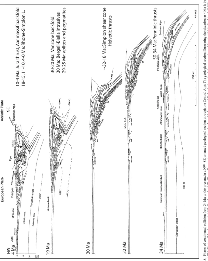
this study presents a review of published geological data, combined with orig-inal observations on the tectonics of the simplon massif and the Lepontine gneiss dome in the Western Alps. New observations concern the geometry of the Oligocene Vanzone back fold, formed under amphibolite facies condi-tions, and of its root between Domodossola and Locarno, which is cut at an acute angle by the Miocene, epi- to anchizonal, dextral centovalli strike-slip fault. the structures of the simplon massif result from collision over 50 Ma between two plate boundaries with a different geometry: the underthrusted European plate and the Adriatic indenter. Detailed mapping and analysis of a complex structural interference pattern, combined with observations on the metamorphic grade of the superimposed structures and radiometric data, al-low a kinematic model to be developed for this zone of oblique continental collision. the following main Alpine tectonic phases and structures may be distinguished:
1. NW-directed nappe emplacement, starting in the Early Eocene (~50 Ma); 2. W, sW and s-verging transverse folds;
3. transpressional movements on the dextral simplon ductile shear zone since ~32 Ma;
4. formation of the bergell – Vanzone backfolds and of the southern steep belt during the Oligocene, emplacement of the mantle derived 31–29 Ma bergell and biella granodiorites and porphyritic andesites as well as intru-sions of 29–25 Ma crustal aplites and pegmatites;
5. formation of the dextral discrete rhone-simplon line and the centovalli line during the Miocene, accompanied by the pull-apart development of the Lepontine gneiss dome – Dent blanche (Valpelline) depression.
It is suggested that movements of shortening in fan shaped NW, W and sW di-rections accompanied the more regular NW- to WNW-directed displacement of the Adriatic indenter during continental collision.
rEsuME
cette étude représente une revue de données géologiques publiées, complé-tées par des observations originales sur la tectonique du massif du simplon et du dôme de gneiss du Lépontin. De nouvelles observations sont rappor-tées sur la géométrie du rétro-pli de Vanzone, formé à l’Oligocène sous des conditions du faciès amphibolite et sur sa racine située entre Domodossola et Locarno, où elle est coupée avec un angle aigu par le décrochement dextre, epi- et anchi-zonale de la faille du centovalli, datée du Miocène. Les struc-tures du massif du simplon résultent de la collision de la plaque européenne sous-charriée et de l’éperon de la plaque adriatique, depuis 50 Ma. ce sont deux bordures de plaques avec une géométrie très différente. Des levés géo-logiques détaillés et l’analyse des structures superposées, combinés avec des observations sur le degré du métamorphisme et des datations radiométriques, permettent de conclure sur un model cinématique de cette zone de collision continentale, de direction oblique et en transpression. Les phases et structures tectoniques alpines suivantes sont distinguées:
1. Dès l’Eocène inférieur (~50 Ma), mise en place des nappes, dans une di-rection NW.
2. Formation de plis transverses de vergence W–sW.
3. Mouvements transpressifs dans la large zone de cisaillement ductile et dex-tre du simplon.
4. A l’Oligocène, formation des plis de rétrocharriage bergell – Vanzone, ver-ticalisation des racines, mise en place des intrusions du bergell, de biella et d’andésites porphyritiques d’origine mantélique datées de 31–29 Ma et intrusion d’aplites et de pegmatites, d’origine crustale datées de 29–25 Ma, 5. Au Miocene, formation des lignes tectoniques dextres rhone-simplon et
des centovalli, accompagnée dans une structure d’extension et de trans-pression, du soulèvement du dôme de gneiss du Lépontin et de l’abaisse-ment de la dépression de la Dent blanche (Valpelline).
Nous concluons que le poinçon adriatique s’est déplacé selon un chemin ré-gulier de direction NW à WNW, accompagné des déformations de raccourcis-sement NW–sE, W–E et sW–NE.
Introduction
the simplon massif and the Lepontine gneiss dome in the cen-tral Alps represent one of the best studied zones of continental collision, which has been investigated for over a 150 years (e.g.
studer 1851; Gerlach 1869; schardt 1903; schmidt & Preiswerk 1905; Argand 1911, 1916; Preiswerk et al. 1934; bearth 1956a & b; Wieland 1966; Hunziker 1969; Hunziker & bearth 1969; Milnes 1973, 1974; Milnes et al. 1981; Frank 1983; steck 1984, 1990; Merle et al. 1989; Lacassin 1989; Mancktelow 1985, 1990, 1992;
tectonics of the simplon massif and Lepontine gneiss dome:
deformation structures due to collision between the underthrusting
European plate and the Adriatic indenter
A
lbrechtS
teckKey words: Alpine tectonics, simplon massif, nappe tectonics, transpression, continental collision 1661-8726/08/020515-32
DOI 10.1007/s00015-008-1283-z birkhäuser Verlag, basel, 2008
swiss J. Geosci. 101 (2008) 515–546
? Fig . 1. b lock diagram of the c entral Alps . t he Lepontine gneiss dome represents a unique exposure of amphibolite grade deformational structures of the deepest level of the Alpine nappe stack (An17-Hb =
Anorthite 1–3/Anorthite 17 limite of the peristerite gap of plagioclase in
Amphibolites , after W enk & K eller 1969, s teck et al. 2001).
steck & Hunziker 1994; steck et al. 1999, 2001; Engi et al. 2001; Keller et al., 2005; Handy & Oberhänsli, 2004; schmid et al. 2004; Maxelon & Mancktelow 2005; Handy et al. 2005; Kon-rad-schmolke et al. 2006; babist et al. 2007). the simplon mas-sif and the Lepontin gneiss dome represent a unique region in the western Alpine arc where deformational structures of its deepest level of the nappe stack are exposed (Plate 1, Fig. 1). the continuous outcrop conditions of the central Alps allow a study of the rock-rheology, dependent change in structural style between a superficial, more rigid, orogenic lid and a deep-seated, very ductile, tectonic stage of the Alps. the complexity of the fold and fault interference pattern in this zone of conti-nental collision exposed in the central Alps (Plate 1) results mainly from the following:
1. the different and complex geometry of the European plate boundary and the Adriatic indenter (Fig. 2); and
2. the change from greenschist facies to higher amphibolite facies grade of the synorogenic barrovian metamorphism, implying a strong change with depth in the ductile proper-ties of the deformed rocks.
Different models have recently been published to explain the complex structures and the tectono-metamorphic history of the Lepontine Alps, and these need to be discussed (Milnes 1974; Milnes et al. 1981; steck, 1984, 1990; steck & Hunziker 1994; Grujic & Mancktelow 1996; steck 1998; Keller et al. 2005, 2006; Maxelon & Mancktelow 2005). New observations are presented in the present work concerning the geometry, kinematics and metamorphism of the Vanzone back fold and the centovalli line. the aim of this study is to review already published data, completed by new observations, and to suggest an updated model for the formation of this complex zone of continental collision exposed in the simplon area.
Geological setting
the simplon area is the region of Eurasia, where schardt (1903), schmidt & Preiswerk (1905) and Argand (1911) discov-ered and proposed the model of the nappe structures of the Alps. this generalisation of the nappe structure model to an entire mountain range happened 36 years after the description of the Antigorio recumbent fold by Gerlach (1869), and over 20 years after the discovery of the Glarus thrust by bertrand (1884). the geology of the central Alps is illustrated in recent geological and tectonic maps (1: 500'000) of switzerland, pub-lished by the Federal Office for Water and Geology (2005) and in an overview map of the Alps by schmid et al. (2004). More detailed tectonic maps in a scale of 1 : 100'000 have been com-piled by steck et al. (1999, 2001) and berger & Mercolli (2006). An updated structural map of the central Alps is represented on Plate 1 and the main tectonic units of the simplon region are listed on table 1 (modified after steck et al. 2001 and berger & Mercolli 2006). the central Alps are composed of pre-triassic, poly- and mono-cyclic crystalline basement units and their Al-pine metamorphosed Mesozoic – cenozoic sedimentary cover
series, Jurassic ophiolites of the Piemont basin (Alpine tethys ocean) and Oligocene intrusives and volcanites, situated along the Periadriatic line. New units have been defined in the core of the Vanzone fold. the following units have been identified below the Antrona ophiolites (Plate 1, Fig. 3, 4):
– the camughera unit composed of porphyritic granite gneisses, that are intrusive into metapelites and amphibo-lites,
– the ruginenta unit, named after a village in the Antrona valley, comprising a basement of similar composition of the camughera basement, which is stratigraphically overlain by the sediments of the salarioli unit (Fig. 4; the “salari-oli mulde” of bearth 1956b, consisting of Permo-Mesozoic sediments), composed of 10–180 m thick black graphite-rich slates, sandstones and microconglomerates of probable carboniferous age, followed by 1–10 m of Permo-triassic Fig. 2. Late Jurassic and Late cretaceous plate geometry preceding the ter-tiary collision of Eurasia, Iberia and Adria (modified after stampfli et al. 2001; bernoulli et al. 2003; Masson 2002; schmid et al. 2004 and Masson et al. sub-mitted; AA = Austroalpine, se = sesia zone, tz = tizia). Note, that the sesia zone (se) has been overprinted by its high pressure metamorphism during a late cretaceous phase of subduction (babist et al. 2007; Hunziker et al. 1992; ruffet et al. 1997; rubatto et al. 1999).
Fig
. 3.
Locality map
phengitic quartzites and above this, boudins of 5–100 m thick triassic dolomites with less than 10% of calcite and quartz. the contact to the higher camughera gneisses is tec-tonic; on the Pso d’Ogaggia it is marked by several meters of cornieules.
– the Moncucco unit, within which we include the up to 400 m thick Moncucco peridotites, a sequence of meta-pelites, paragneisses, and amphibolites, an approximately 50 m wide fold hinge containing white siliceous marbles, outcropping at the Alpe Pradurino (Paleozoic or Meso-zoic?; bearth 1956b), and, in the core of the isoclinal Van-zone fold, the Moncucco porphyritic bi-mu-granite-gneiss, which is up to 700 m wide and has an age of 271 ± 4,8 Ma, (rb-sr, biggogero et al. 1981).
the distinction and correlation of the units in the Vanzone fold below the Antrona ophiolites is similar to the proposition of Milnes in steck et al. (1979; Milnes & Müller in trümpy 1980): the Moncucco unit of this study is attributed by Milnes to the
Monte Leone nappe. the rugginenta unit is named Moncucco unit and the camughera unit of this study camughera unit following the propositions of bearth (1957). the two latter units correspond to the southern root of the bernhard nappe of Argand (1911, 1916; Milnes in steck et al. 1979). Keller et al. (2005) correlate their camughera-Moncucco unit with the Monte Leone gneiss to the north of the Valle bognanco. bearth (1957) and Keller et al. (2005) propose that the bernhard or siviez-Mischabel nappe to the north of the Antrona ophio-lites is a root less unit with no southern continuation in the camughera-Moncucco units. the proposed separation of the ruginenta and Moncucco units of this study is arbitrary and it cannot be ruled out that the two units actually belong to the same tectonic unit, as proposed by Argand (1911). It is also pos-sible that the siliceous marbles of Alpe Pradurino represent a relict of Mesozoic sediments marking the boundary of these two tectonic units, as proposed on the geological and tectonic maps of switzerland, 1: 500'000 of the Federal Office for Wa-ter and Geology (2005). In this case, the Moncucco and Mon-Fig. 4. stratigraphy of the carboniferous and Permo-triassic sedimentary cover of the ruginenta unit (Antrona valley). the name “salarioli unit” is proposed for the whole carboniferous – triassic sedimentary sequence that lies in a normal stratigraphic position on the ruginenta basement and forms a tectonic contact with the higher camughera basement. Note that bearth (1956b) and (Keller et al. 2005) used the term “salarioli Mulde” for the Permo-triassic sediments, that form, after their interpretation, a syncline (Mulde) in the camughera unit.
dei peridotites belong to the upper unit, i.e. the newly defined ruginenta unit. On Plate 1 and Fig. 1, the camughera unit is correlated with the siviez-Mischabel nappe, whereas the rugi-nenta unit is correlated with the Pontis-berisal nappe and the Moncucco unit with the Monte Leone nappe. this correlation is based largely on the tectonic position within the nappe pile (after unfolding of the last phases) and lithological affinity. It is also possible that a part of the Moncucco unit represents a lateral equivalent of the bosco – Isorno – Orselina zone, which is characterised by numerous ultramafic bodies (cima d’Agaro, Albogno etc., 5 ant 6 on Plate 1).
The pre-Alpine Cretaceous paleogeography
In this study we refer to investigations and models by trümpy (1980), stampfli et al. (2001); bernoulli et al. (2003) and schmid et al. (2004) for the Late cretaceous paleogeography of the west-Mediterranean area, modified after Masson (2002; Mas-son et al. 2008; Fig. 2) prior to closure of the Piemont ocean (Alpine tethys) and continental collision of Eurasia with the Adriatic indenter. the opening of the Piemont ocean is con-strained by radiometric dating: the gabbroic blocks of the Gets nappe flysch have an age of 166 ± 1 Ma (u-Pb zircon age, bill et al. 1997), the gabbros of the Zermatt-saas Fee ophiol-ites ages of 164 ± 2.7 Ma (Allalin gabbro) and 163.5 ± 1.8 Ma (Mellichen gabbro, rubatto et al. 1996), the Antrona ophiolites an age of 163.1 ± 2.4 Ma, 158 ± 17 Ma and 155.6 ± 2.1 Ma and the Misox zone that of 161.0 ± 3.9 Ma (Liati et al. 2005). these ages suggest progressive opening of the Piemont ocean, from the Middle to the Late Jurassic and from s to N. A cretaceous u-Pb age of 93.4 ± 1.7 Ma of magmatic zircons has been found by Liati & Froitzheim (2006) in an eclogitic metabasite of their newly defined balma unit in the roof of the Monte rosa nappe (2 km to the E of Point 2 on Figure 7). the authors suggest that the balma unit belongs to the Valais basin. In this study it is sug-gested that either the dated metabasites belong to the Zermatt – saas Fee ophiolites or to the Furggzone. the age testify in the first case of a cretaceous continuation of basaltic magmatism in the Piemont ocean or represents in the second case basal-tic dikes intruding the Paleozoic to upper Jurassic Furgg sedi-ments as observed at the passo della Preja (steck et al. 2001). It is also important to note that the gabbro intrusions, within the ophiolites of the Versoyen zone are in tectonic contact with the cretaceous sion-courmayeur-tarantaise flysch unit and have been dated at 334 ± 4 Ma (sHrIMP u-Pb age on zircon, bussy et al. 2005; Masson et al. 2008). the Versoyen ophiol-ites represent the Paleozoic basement that is stratigraphically overlain by the triassic dolomites and Liassic calcschists of the Petit st. bernhard tectonic unit. the carboniferous Versoyen ophiolites and its Mesozoic sedimentary cover are together overprinted by an Alpine eclogite facies metamorphism (bous-quet et al. 2002) and form the newly defined Versoyen-Petit st. bernhard unit (Masson et al. 2008). A wildflysch (Méchan-deur Formation) with elements of the latter unit is exposed in the Versoyen valley on the tectonic contact between the
Pa-leozoic ophiolites of the Versoyen-Petit st. bernhard nappe on top and the sion-courmayeur-tarantaise calcschist unit of the Valais zone below. this wildflysch is interpreted (Masson et al. 2008) as the youngest sediment of the sion-courmayeur-tarantaise unit. this wildflysch may be a southern equivalent of the mélange of Visp (Visp wildflysch on Fig. 5; Masson 2002, 2006; Masson et al. 2008). the ophiolites from Visp (Valais, switzerland) represent blocks and olistoliths in the polygenic Visp olistostrome (mélange, wildflysch, Masson 2002; ensemble du Furgguwald, steck 1987; Visp wildflysch on Fig. 5). It fol-lows that the Late cretaceous (?) to Eocene Valais basin was an important marine wrench basin with a thick succession of Late cretaceous (?) to Priabonian flyschoid sediments (calc-schists or “bündnerschiefer”), with Middle Jurassic ophiolites only in Eastern switzerland, in the Misox zone (161.0 ± 3.9 Ma; Liati et al. 2005), and in the ramosch zone of the Engadine window (Florineth & Froitzheim 1994), where the Valais trench basin reaches the Piemont ocean with its oceanic crust (trümpy 1980). In conclusion, the Late cretaceous (?) to Priabonian Valais basin, of western switzerland, was not the cretaceous ocean with an oceanic crust, as proposed in classical and recent paleogeographic models of the Alps (trümpy 1980; Froitzheim et al. 1996; stampfli et al. 2001; schmid et al. 2004). the root of the sion-courmayeur-tarantaise flysch is situated in the Val-ais suture on the limit of the European (Helvetic) and brian-çonnais domains (Plate 1, Fig. 1 & table 1). An other ophiolite sequence, composed of meta-peridotites, -gabbros and -basalts is associated with the continental rocks of the Moncucco and bosco-Isorno-Orselina units, in the latter with carbonate sedi-ments. the age of this ophiolites is unknown, probably Paleozic and/or Mesozoic. these units are rooting north of the Monte Leone gneiss and sion-courmayeur-tarantaise flysch in the Valais suture (table 1, Fig. 1 and Plate 1). the subduction, ex-humation and accretion of the sesia zone as a part of the Adri-atic margin occurred in the Late cretaceous before the closure of the Piemont ocean (Konrad-schmolke et al. 2006; Handy et al. 2005; babist et al. 2007). the sesia high-pressure metamor-phism was dated of 65–68 Ma (Hunziker et al. 1993; Duchène et al. 1997; rubatto et al. 1998, 1999; babist et al. 2007).
Alpine continental collision and orogenic metamorphism rock deformation and metamorphism are interdependent pro-cesses that characterise a zone of continental collision. Apart from composition the mechanisms of deformation depend on the pressure – temperature – time conditions, and the age of the deformational events may be constrained by radiometric dating of metamorphic minerals and synorogenic magmatic rocks. N-NW-directed fold nappes and thrusts are early Alpine structures related to continental collision (Fig. 5). these nappes have been formed by the detachment of the upper part of oce-anic and continental crust of the Austro-alpine continental do-main (sesia zone), the Piemont oceanic crust, and the brian-çonnais and European continental crust, during underthrusting to the sE below the Adriatic plate. these units were subducted
Fig . 5. t he classic NW– sE geological profile of the simplon railway tunnel after schmidt & Preiswerk (1905), Milnes (1973) and steck (1984) completed with results from the deep seismic study of the V al d’Anniviers and V isp-Zermatt valley sections (s teck et al. 1997). Note that the second axial surface schistosity s2 of the younger Antigorio fold nappe becomes a third schistosity s3 in the
higher and older Lebendun nappe
to different depths before their detachment, extrusion and ac-cretion in the Alpine orogenic belt. Eclogite facies mineral as-semblages, with coesite in the Zermatt – saas-Fee nappe, testify that in an early stage of subduction, some units reached a depth of over 90 km before their very rapid extrusion (trommsdorff 1991; reinecke 1998; Engi et al. 2001; 2004; bucher et al. 2003) in a so-called tectonic accretionary channel (tAc), a term ap-plied by Engi et al. (2001). both the resultant structures and the mechanism of extrusion in this Early-Alpine tectonic ac-cretionary channel are complex and still not well understood. the great volume of low-density serpentinites in the Zermatt – saas-Fee zone may be responsible for an important support by buoyancy driven extrusion of this high-pressure unit. two periods of high-pressure metamorphism have been dated in the transect of the Western Alps considered here: the sesia zone metamorphism of Late cretaceous age (Hunziker et al. 1992; Duchène et al. 1997; ruffet et al. 1997; rubatto et al. 1999; babist et al. 2007) and Alpine middle Eocene metamorphism of the ophiolitic Zermatt-saas Fee and Antrona, the Monte
rosa, Portjengrat and cimalunga-Adula units dated 50–40 Ma (becker 1993; Gebauer 1999; Amato et al. 1999; Engi et al. 2001; Lapen et al. 2003; Mahlen et al. 2005). the whole Alpine nappe stack was then overprinted by a younger late Eocene barro-vian regional metamorphism. this Alpine nappe stack consists of (from top to bottom) the Austroalpine Dent blanche nappe, the upper Penninic ophiolitic tsaté, Zermatt-saas Fee and Antrona nappes of Piemont ocean origin, the Middle Penninic continental Monte rosa, Portjengrat-Furgg, cimes blanches-Frilihorn, siviez-Mischabel, Pontis-berisal and Zone Houillère nappes of the briançonnais domain, and the Lower Penninic cretaceous – Priabonian Valais calcschists, the continental Monte Leone, bosco-Isorno-Orselina (with ophiolites), Leb-endun-bombogno, Maggia, someo-cimalunga-Adula, Antigo-rio-Pioda di crana-simano, Verampio, Leventina-Lucomagno nappes and the Helvetic Gotthard, tavetsch, Aar and Gastern gneiss folds and their sedimentary cover nappes (Plate 1, Fig. 1 and table 1). the greenschist-facies metasediments of the Va-lais basin contain relicts of a blueschist-facies event related
table 1. List of the Alpine tectonic units of the simplon area represented on Plate 1, modified after steck et al. (1999, 2001), Geologische Karte der schweiz, 1: 500'000 (2005); berger & Mercolli (2006).
to an external Valais subduction zone (bousquet et al. 2004; Oberhänsli & Goffé 2004). the Monte Leone nappe contains 3t-polytype phengite relicts of a high-pressure metamorphism overprinted by the regional amphibolite-facies metamorphism (Hammerschmidt & Frank 1991) and may belong to the same external Valais subduction zone. the temperature peak of the barrovian regional metamorphism was dated by Hunziker et
al. (1992) and Markley et al. (1998) with the rb-sr and 40Ar/
39Ar- methods on white mica at about 41 to 36 Ma in the middle
Penninic siviez-Mischabel nappe. Younger ages in the centre of the Lepontine gneiss dome are interpreted as cooling ages, where amphibolite facies conditions lasted to 26 Ma (Hurford 1986; Hunziker et al. 1992; steck and Hunziker 1994). A similar metamorphic history lasting from early eclogite facies to the younger barrovian metamorphic phase is corroborated by u-Pb monazite dating by Engi et al. (2001). the u-u-Pb monazite ages range in a W–E profile through the Monte rosa nappe from 46–41 Ma (eclogite facies event) in the Macugnaga re-gion, 41–34 Ma near Antrona, 33–26 Ma at beura in the Os-sola valley and 33–31 Ma in the Pizzo tignolino-Pizzo ragno region of the Vigezzo valley (Fig. 3). Peak amphibolite facies metamorphic conditions of 700 °c and 9.5 kbar were reached in garnet-phengite-biotite-plagioclase-kyanite-staurolite min-eral assemblages of the camughera and ruginenta units of the Antrona valley (Keller et al. 2005). Furthermore secondary high temperature of 700 °c and low pressure of 7 kbar conditions, indicated by sillimanite-staurolite assemblages, occur in the ruginenta unit, 2–4 km to the W of Domodossola (Keller et al. 2005). the nearly isothermal pressure drop was assisted by the synmetamorphic uplift and erosion of the Vanzone backfold. the isotopic readjustment or recrystallisation of the monazites at 33–31 Ma may be explained by the penetrative and synmeta-morphic rock deformation and related fluid migration, during the Vanzone backfolding and straightening up of the southern steep belt. this deformation phase was also accompanied by the mantle derived 30 Ma porphyritic andesite and 29–25 Ma crustal aplite and pegmatite intrusions (Fig. 16a; romer et al. 1996; schärer et al. 1996). the mesoalpine barrovian regional metamorphism of the central Alps resulted from complex thermal perturbations in the crust, related to continental col-lision, nappe stacking, folding, doming (Lepontine dome, Van-zone backfold) and heat advection by extruding nappes and synorogenic mantle derived plutons and dykes (bergell and biella granodiorites and tonalities and porphyritic andesites; (beccaluva et al. 1983; von blanckenburg 1992; trommsdorff & Nievergelt 1983); crust-derived acidic dykes (aplites and peg-matites) and metamorphic fluids (romer et al. 1996; schärer et al. 1996).
N–NW-directed fold nappes and thrusts
the late Alpine uplift and erosion of the Lepontine gneiss dome offer the opportunity to study, in the central Alps, a complete transect from the cold tectonic lid of the orogen to the complex structures of the deep tectonic level of the Alpine nappe stack,
deformed under upper amphibolite facies conditions. the nappe stack represented on Plate 1, Fig. 1 and tables 1 and 2 is similar to that illustrated on the geological and tectonic maps of switzerland 1: 500'000 (2005) and the 1 : 100'000 tectonic maps of the Alps of western switzerland (steck et al. 1999; 2001) and of the sopra ceneri (berger & Mercolli 2006). Fig. 5 illustrates the classical geological profile of the simplon rail-way tunnel after schardt (1903), schmidt & Preiswerk (1905), Milnes (1973), steck (1984, 1987) updatet with results from the Val d’Anniviers and Visp-Zermatt valley seismic profiles (Marchant et al. 1993, steck et al. 1997, steck in Delaloye et al. 2005). Most of the basement nappes of the Helvetic and lower and middle Penninic domains have a fold-nappe geometry, with a well developed inverted fold limb (Fig. 5–9); Argand 1911, 1916; steck 1984, 1987; Epard 1986; 1990; Escher et al. 1993; Genier et al. 2008). the basement folds, fold nappes and the sedimentary cover nappes are characterized by an initial s to sE-plunging stretching lineation XI (XI = stretching lineation of deformation phase DI, further explanation see below) and mainly top-to-the N and NW directed shear indicators (Figs. 6 & 7a; Masson et al. 1980; steck 1980, 1984, 1987, 1990; sartory 1987; steck & Hunziker 1994; Genier et al. 2008).
the understanding of the present paper needs a short dis-cussion of the used definitions and nomenclature of deforma-tional structures. Folds, schistosities and shear zones are dis-tinguished. Arabic numbers (s1, s2, s3 … and F1, F2, F3 …) designate schistosities or crenulation cleavages and folding phases. roman numbers (XI, XII, XIII & XIV) designate the specific stretching lineation of ductile shear zones and of defor-mation phases DI–DIV. X denote the great axes of the strain ellipsoid on the schistosity plain defined by the Y and Z axes (ramsay 1967). these structures may be considered as defor-mation phases, that last for a certain time and are syn- or hetero-chronously in space. A specific deformation may also develop at different places either syn- or heterochronously. this may be illustrated by the following examples. In the Doldenhorn foldnappe and also in the simplon area the same stretching lineation XI was observed associated to a succession of schis-tosities and crenulation cleavages s1-s2 or s1-s3, testifying of a mechanism of progressive rotational deformation in a same shear zone. In the Doldenhorn foldnappe three schistosities and folding phases s1-s3 and F1-F3 were developed in its my-lonitic inverted limb and only one or two schistosities and fold-ing phases occurred in its less deformed normal limb and fold hinge (steck 1984).
the nappe emplacement took place in a regime of ductile deformation by extrusional flow. Epard & Escher (1996) and Escher & beaumont (1997) suggest a mechanism of simple shear flow and superimposed wedge-shaped pure shear flow.
40Ar/39Ar white mica ages in the Middle Penninic
siviez-Mis-chabel nappe, characterized by the XI-stretching lineation, are 40–35 Ma (Fig. 6; Markley et al. 1998). this is the age of the barrovian metamorphism and corresponds to the age of the middle Penninic fold nappe emplacement in the central Alps, which post-date deposition of the black Eocene flysch of the
barrhorn sedimentary cover of the siviez-Mischabel nappe (sartori 1987). the thrusting of the Lower Penninic Verampio – Monte Leone nappes is younger than the youngest Priabonian flysch deposits of the Valais basin (Fig. 7a, sion-courmayeur zone; bagnoud et al. 1998). the Helvetic thrusts started after the deposition of the taveyanne flysch, with its 33–32 Ma an-desitic volcanites (ruffini et al. 1995, 1997). the Prealps were thrusted on the sub-Alpine Molasse after 25–23 Ma. the pro-gressive migration of the deformation from internal higher to external deeper nappes is well documented by the structural relations between the Lebendun nappe with its three schistosi-ties and the younger Antigorio nappe with its two schistosischistosi-ties, that correspond to the second and third schistosities of the older Lebendun nappe (Fig. 5, 7a).
W, SW and S-verging transverse folds
the fan shaped, N- to NW-directed thrusting and related stretching lineation XI of the nappe stack was in a late stage overprinted by W-, sW- and s-verging folds. these transverse-folds are from E to W the Verzasca anticline, the Maggia syn-cline, the Ziccher anticline and the Wandfluhhorn (Wa) anti-formal syncline (Plate 1, Fig. 7b; steck & Hunziker 1994; steck 1998). the steep Maggia syncline was since a long time recog-nized by Preiswerk (1918), Wenk (1955) and Merle et al. (1992). Merle et al. (1992) suggested that the Wandfluhhorn and Mag-gia folds were formed under retrograde greenschist-facies con-ditions. New data, however, show that these transverse folds were still formed under amphibolite facies conditions with fold axes oriented parallel to the XI-stretching lineation (LIV on
Fig. 7b; Wenk 1955; Wenk & Keller 1969; steck 1998; Allaz et al. 2005). the sambuco unit and the steep Maggia transverse fold are represented on the tectonic map and the block diagram (Plate 1, Fig. 1) as two klippen situated above the Antigorio and simano nappes, following the observations of Keller et al. (1980) on the geological map sheet “campo tencia”. the limit between the biotite-hornblende-plagioclase-Alpigia-tonalite-gneiss of the Antigorio nappe and the simano metapelite may be an intrusive contact in a single Antigorio-simano nappe and not a tectonic limit of two nappes. An other solution, also based on the observations of Keller et al. (1980), was proposed by berger & Mercolli (2006). For these autors the sambuco unit represents a sub-unit of the simano nappe. the models of Gru-jic & Mancktelow (1996) and Maxelon & Mancktelow (2005), which consider the Maggia steep zone as a nappe sheet that separates the deeper Antigorio from the higher simano nappe, are incompatible with the field data and geological map of Keller et al. (1980; steck 1998; Kröner 2000; berger & Mercolli 2006; Plate 1). the Maggia and sambuco units are represented on the map of Keller et al. (1980) as two synclines (klippen) on top of the Antigorio – simano nappes. the major difference between the interpretation of this study in agreement with Keller et al. (1980) and the models Grujic & Mancktelow and Maxelon & Mancktelow, respectively is, that the latter inter-pret the Mogno fold (Mesozoic sediments that separates the Maggia from the simano nappe) at Fusio as a simple syncline, while in this study the Mogno fold is interpreted as a antifor-mal syncline. the axis of this antiforantifor-mal syncline plunges with an angle of 20° to the s, and consequently it represents an an-tiform and the Maggia nappe is situated above both the An-Fig. 6. Orientation of the sE-plunging XI -stretch-ing lineation (black ellipses) of the Eocene to Earliest Oligocene middle and upper Penninic and Austroalpine nappes, formed between ~50 and 34 Ma and XI-stretching lineation (open ellipses) in Lower Penninic nappes, formed be-tween ~34 and 32 Ma (modified after steck 1990; 2DK = seconda zona diorito-kinzigitica).
tigorio and simano nappes (Preiswerk 1919; Preiswerk et al. 1934; steck, 1998). A similar geometric relation is observed to the s, where the Maggia nappe overlies the someo-cimalunga and the deeper Antigorio-simano nappes (Plate 1, Fig. 1; steck 1998; burri 2005; berger et al. 2007; brower et al. 2005). the amplitude of the transverse folds grows drastically from N to s and with depth, with the increasing, temperature-dependent ductility of the deformed gneisses. the frontal NE-striking anticlinal F2-fold hinge, of the Antigorio – simano nappes, is only folded by the Maggia transverse fold. the amplitude of the Maggia syncline decreases and disappears in the frontal sambuco spoon and it increases in the Maggia nappe to the s. the isoclinal Ziccher anticline and Wandfluhorn antiformal synclines do not fold the frontal Antigorio hinge. their ampli-tudes increase drastically from N to s and with depth, where they reach amplitude of over 25 km. this change in style of de-formation with depth, observed in the Lepontine gneiss dome, is interpreted to illustrate the progressive passage from a more rigid high tectonic level in the N, to a very ductile deep tectonic level of the Alpine nappe stack in the s. It is possible that the s–sW-verging Mischabel (10 on Figs. 8–11), stockhorn and ci-malegna folds (2 on Figs. 8–11), that are situated in a higher (greenschist facies) tectonic level of the orogen, belong to the same phase of deformation (D4, F4, Plate 1, Figs. 8, 9, 11). the huge sW-verging nearly isoclinal transverse folds of the Lepon-tine gneiss dome suggest a NE–sW shortening, perpendicular to the foldaxis and a W-directed drift of the Adriatic front si-multaneously with its NW–W-directed over thrusting. the for-mation of the sW-verging transverse-folds may be considered as a phase of transition between the early nappe detachment during the sE-directed underthrusting of the European plate below the Adriatic plate and subsequent movements of dextral transpression in the zone of continental collision in the dextral simplon ductile shear zone. More details are given in the next chapter. Note, that the described model for the Wandfluhhorn transverse fold differs fundamentally from the dissimilar mod-els proposed by Milnes (1974) and Maxelon & Mancktelow (2005). the axial surface of the Wandfluhhorn fold is identical with the axial surface of the Monte Leone fold nappe in the Milnes (1974) model. the axial surface of the Wandfluhhorn fold is identical with the axial surface of the frontal Antigorio fold nappe in the Maxelon & Mancktelow (2005) model. the Wandfluhorn fold deforms the normal limb of the Antigorio F2 fold (Plate 1). that means that this fold belongs to a younger deformation phase and for this reason the axial trace of the Antigorio recumbent F2 fold cannot be identical with the axial trace of the Wandfluhhorn F4 fold, as proposed by Maxelon & Macktelow (2005). the Monte Leone nappe is folded together with the bosco-Isorno-Orselina, bombogno (= Lebendun) and the normal limb of the Antigorio F2-fold in the Wandfluhhorn F4-fold (Plate 1). Milnes (1974) supposed that the axial trace of the Wandfluhornfold continues farther ouest as axial trace of a isoclinal Monte Leone foldnappe. this suggestion is unlikely, because the frontal Monte Leone nappe fold hinge near Visp is a second F2-fold like the frontal Antigorio F2-fold, that is
refolded by the younger Wandfluhhorn fold. the geometrical information’s represented on the structural map (Plate 1 and the 1 : 100'000 tectonic map of the Alpes of western switzerland by steck et al. 1999) show clearly that the Wandfluhhorn F4-fold deform both, the pre-existing NW-verging Antigorio and Monte Leone F2-fold nappes (steck 1987; steck & Hunziker 1994).
The dextral Simplon ductile shear zone
A second sW-oriented stretching lineation, XII, is related to NE–sW extension and top-to-the sW shear of the simplon ductile shear zone (Fig. 7c; steck 1980, 1984, 1990; Dolivo 1982). the northern and southern boundaries of this 10–20 km thick, (on the map up to 30 km wide), ~25° south dipping, dextral shear zone, cross the Alps obliquely in a W–E direction, from the Helvetic zone to the W to the Austroalpine sesia zone to the E. the formation of open folds F5 with axis and dextral shear parallel to the stretching lineation are probably contempora-neous, as discussed later. the second deformation DII (XII) transposes an earlier schistosity with the older XI-stretching lineation (DI), often without forming a new schistosity. the final deformation corresponds in this case to the sum of the two deformation phases and the sense of shear indicators are difficult to interpret. A minimum sW-directed displacement, of the hanging-wall of the simplon shear zone of about 60 km was estimated, based on a quantification of the finite strain el-lipsoid and the width of the shear zone (steck 1984). Xenoliths in granite gneisses and pebbles in conglomerates as well as the total width of the ductile simplon shear zone were used for quantification. A minimal relative displacement of 60 km was calculated for a mean value of 1 + e1 = 4 parallel to the stretch-ing lineation XII and a mean thickness of 15 km of the simplon ductile shear zone. the deformation of the very ductile calc-schists, separating the gneiss folds, was certainly more intense, so that the displacement was probably in the order of 100 km. that means that also the sesia-Dent blanche nappe and the southern Alps have been displaced by 60 to over 100 km in a WsW-direction relative to the deep-seated European, Ver-ampio, Gotthard and Aar units (steck 1980, 1984, 1990).
31–29 Ma porphyritic dikes crosscut stretched gneisses in the Loana valley, with a pre-existing intense amphibolite fa-cies stretching lineation XII. the dikes are then overprinted by a weaker younger mineral stretching XIV parallel to XII (Fig. 17). similar age relations are observed with the 29–25 Ma aplites and pegmatites of the Vigezzo valley steep zone, between the toce valley and Locarno (Fig. 16a). the third Deformation DIII with a steep NW-plunging stretching lineation XIII, and with top-sE sense of shear was not observed in the steep belt between Domodossola and Locarno. the stretching lineation XIII was developed in the mylonites of the sesia zone (schisti di Fobella et rimella) along the canavese line from the toce valley to the sE (steck 1990). the formation of the dextral sim-plon ductile shear zone started before 30 Ma, probably around 32 Ma ago, and continued until 18 Ma, the time when it was
relieved by the discrete (more brittle) dextral rhone – simplon line (steck, 1984; steck & Hunziker 1994; romer et al. 1996; schärer et al. 1996). the DII dextral shear deformation is dated
by 40Ar/39Ar-ages on synkinematic white mica in the range of
35–30 Ma in the Visp valley (data of Markley et al. 1998). Mark-ley et al. (1998) interpreted these ages as the result of thermic rejuvenation above the 18–15 Ma simplon normal fault. In this study the data of Markley et al. (1998) are interpreted as the age of the synmetamorphic deformation in the ductile simplon shear zone (Genier et al. 2008). the Helvetic nappes and the frontal Aar massif basement folds were thrusted between 32 and 16 Ma parallel to the XI-stretching lineation to the NW
and this during the dextral transpression in the simplon ductile shear zone (Fig. 7c; steck 1984, 1990; Lacassin 1989).
S–SE verging back folds (Vanzone and Bergell back folds) the simplon ductile shear zone is folded by the sE-verging Vanzone back fold and this during activity of dextral ductile shear (Figs. 7c, d & 8–12). Argand (1911, 1916) named this phase of Alpine back folding the Insubric phase. the folding of the schistosity, with the sW-directed stretching lineation, XII, can be studied in good outcrops in the Antrona valley. the stretching lineation XII is parallel to the fold axis in the Van-Fig. 7. a–d) the four main phases of structural evolution (a–d) of the simplon area during continental collision of Europe and Adria (modified after steck 1990): a) the NW-directed, ~34–32 Ma lower Penninic thrusts and folds, with a sE-plunging stretching lineation XI. b) the ~32 Ma W–s-verging transverse folds (“Querfalten”), Verzasca anticline, Maggia – sambuco syncline, Ziccher anticline and Wandfluhorn syncline (the cimalunga-someo unit, see Plate 1, is not rep-resented). c) the 32–18 Ma, 10–15 km thick dextral simplon ductile shear zone, with its sW-dipping stretching lineation XII (black ellipses), crosses the central Alps from the Helvetic zone to the W to the Austroalpine sesia zone to the E. this dextral shear occurred contemporaneously with the 32–16 Ma NW-directed Helvetic thrusting, parallel to the XI-stretching lineation (open ellipses). Formation of sE-verging Vanzone backfolds since 30 Ma and during dextral strike-slip movements on the simplon ductile shear zone. d) Formation of the more discrete dextral rhone-simplon line (r–sL) since 18 Ma, the ~10 Ma Glishorn – berisal backfold and before and during this time, the 14–4 Ma detachment and dextral strike-slip movements on the centovalli line (cL).
Fig . 8. s tructural map of the simplon region, the Monte r osa nappe , the V anzone backfold and the discrete dextral r hone-simplon and c entovalli lines . Note the extensional boudinage , with rota -tions of blocks in the eastern Monte r osa root of the anchizonal and dextral c entovalli strike-slip zone , between s. Maria Maggiore and the Maggia valley (localities 5–9). t he numbers 1–19 are the
localities of the equal area stereoplots (lower hemisphere) of F
ig
zone fold (equal area nets 12–16 on Fig. 11). the XII-lineation is in rare cases itself folded, whereas in other cases, younger fold-axis-parallel dextral shear overprints the two limbs of the Vanzone anticline (Fig. 14). these observations lead to the conclusion that the dextral shear preceded, accompanied and outlasted the back folding (steck 1990; Keller et al. 2005). the geometry of the hinge of the Vanzone backfold changes gradu-ally from W to E, with the increasing grade of the barrovian regional metamorphism, from greenschist grade on the western border of the Monte rosa nappe to amphibolite facies grade with staurolite and kyanite, in the toce valley. Also the fold ge-ometry changes, with the increasing ductile deformation from an open fold at the western border of the Monte rosa nappe (locality 2 on Fig. 8–11), to an isoclinal, as seen in the granitic gneiss of the Moncucco unit in the core of the Vanzone fold (Milnes et al. 1981, see also steck et al. 1979; Plate 1, Figs. 8–12). the observations on the geometry and the axial surface trace of the Vanzone fold of this study (Plate 1, Figs. 2, 8–12) differ from
the geological map and description published by Keller et al. (2005, Fig. 3; Keller et al. 2006). After Keller et al. (2005, 2006) the Vanzone axial trace does not continue into the Moncucco granite gneiss; it ends to the N of the Moncucco peridotite and the Moncucco summit. these authors interpret its continuation farther NE by en-echelon anticlines and synclines such as their brevettola antiform and Masera synform. In our interpretation the latter are secondary folds formed during retrograde meta-morphic conditions in the northern limb of the main Vanzone anticline. While this study distinguish the amphibolite facies Vancone fold (old, Fig. 12, 13a & b) from the greenschist facies and anchizonal low grade structures of the Masera fold system (Fig. 15). Keller et al. (2005, 2006) interpret a contemporaneous evolution of the folds.
the fold hinge of the Vanzone fold is well exposed at the type locality, north of the village of Vanzone, where the An-trona ophiolites are folded together with Monte rosa and camughera gneisses (bearth 1956b, 1957). We followed from Fig. 9. NW–sE oriented geological sections through the simplon region (sections A, b, c and D on Fig. 7; MP = barrovian Medium pressure metamorphism, HP = High to ultra-High Pressure metamorphism; 550 °c isotherm of the ti-hbl geothermometer, after colombi 1989).
there the axial trace to the E. the fold hinge is exposed at the salarioli pass, at the southern head of the bridge of ruginenta in the Antrona valley (Fig. 3, 14), at Alpe Pradurino (where the hinge is marked by an outcrop of white siliceous marbles, sur-rounded on both fold limbs by meta-pelites and the Moncucco peridotites, bearth 1956b), and at the southern ridge of the Moncucco (situated in the core of the porphyritic Moncucco granite gneiss; Fig. 12 & 13a,b). the trace of the Vanzone fold continues farther E in the core of the Moncucco granite gneiss. It is crossed in two places by the Domodossola – Alpe Lusen-tino road and reaches the toce valley below the church of the calvario of Domodossola. the fold hinge is formed by a parag-neiss in the core of the Monucco granite gparag-neiss, exposed in the steep wall behind the trattoria Isola, on the beura road on the eastern side of the toce valley. A last outcrop of the Vanzone fold hinge was observed 3 km farther E, near the chapel of s. rocco, at an altitude of 880 m, on the upper end of the road starting at the village of Verigo in the Vigezzo valley (Fig. 3).
the study of the fold hinges in the Moncucco granite-gneiss reveals a postkinematic amphibolite-facies growth texture of quartz, K-feldspar, plagioclase, with myrmekite (plagio-clase + quartz) overgrowth of K-feldspar, muscovite and bio-tite (Figs. 12, 13a, b). the Vanzone structure folds the isopleths of the ti-content in hornblende and the isograd marked by the reaction: albite = edenite + 4 quartz, of the barrovian regional metamorphism. the hinges of the folded isograds are situated farther N of the Vanzone fold hinge, as outlined by the litho-logic boundaries (Fig. 9, 10; colombi 1989). this discordance between folded isograds and lithological boundaries may sug-gest that the cooling by exhumation and folding controlled ero-sion was synmetamorphic and that the cooling was greater in the southern fold limb, in contact with the colder Ivrea rocks south of the canavese line, than in the Alpine metamorphic gneiss dome to the N. An additional argument for synmetamor-phic high temperature folding of the Vanzone anticline is the postkinematic amphibolite facies fabric in the fold hinge of the Moncucco granite gneiss (Figs 12 & 13a, b). the LA PMMs u-Pb Monazite ages vary between 33 and 26 Ma in Monte rosa gneiss samples from beura, the Pizzo tignolino and the Pizzo ragno (Engi et al. 2001). these young monazite ages may be explained by rejuvenation or crystallisation related to a pen-etrative deformation and simultaneous fluid migration in the synmetamorphic Vanzone back fold. this may also be the start-ing age of the synmetamorphic uplift and coolstart-ing of the Van-zone back fold north of the canavese line. the Insubric phase of back-folding was responsible for the rapid cooling, by uplift and erosion of the central Alpine root zone and the creation of the southern steep belt between the Ossola valley and the bergell area, since 30 Ma (Hurford 1986; schmid et al. 1987; Hunziker et al. 1992; steck & Hunziker 1994; berger at al. 1996; schmid et al. 1996). Zircon and apatite fission track data from the toce valley suggest, that vertical displacements related to the Vanzone back-folding ended between 12–6 Ma ago (Fa-zis 2004; Keller et al. 2005). these authors observe no jump in the zircon and apatite fission track ages along the
Verampio-Piedimulera transect of the toce valley. the fission track ages range between 6.4–12 Ma for zircon and 2.2–5.8 Ma for apa-tite and become progressively older going from north to south, indicating a late regional uplift of the more northern parts of the area around the toce culmination. However, these data do not exclude the continuation of horizontal strike-slip displace-ments along the simplon – centovalli lines.
The Oligocene intrusives of the southern steep belt
the intrusives of the southern Alpine steep belt, between the toce valley and Locarno, are of two types:
1. mantle derived tonalites and granodiorites (biella, traver-sella, bergell) and porphyritic andesites
2. aplites and pegmatites, derived from melts of crustal ana-texis, exposed in the steep zone between Domodossola to the W and the bergell intrusion to the E (Fig. 16a).
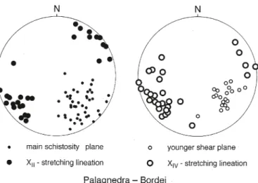
the first group (1), the so-called periadriatic intrusions, were formed from basaltic magmas by partial fusion of the mantle lithosphere and mixed with anatectic crustal magmas (trom-msdorff & Nievergelt 1983; berger et al. 1996). they are dated 32–29 Ma (beccaluva et al. 1983; von blanckenburg 1992). Von blanckenburg et al. (1998) suggest that this 30 Ma magmatic event was related to a slab break-off of the root of the Eu-ropean lithosphere. the second group (2) consists of aplites and pegmatites, dated between 29–25 Ma (romer et al. 1996; schärer et al. 1996) and derived from the partial melting of up-per crustal rocks, at a deeup-per migmatic level of the tertiary bar-rovian regional metamorphism within the southern steep zone. contact of the dikes with the surrounding migmatites of the Palaeozoic basement gneisses is always sharp (Fig. 16a). two samples of the Hercynian migmatite leucosomes from corcap-olo (Fig. 16a) and Lavertezzo reveals ages of 280–290 Ma (romer et al. 1996). Migmatites of undisputed Oligocene age are only observed between bellinzona and the bergell (Hänni et al. 1975). Oligocene dikes were used to date the deformation in the southern steep belt (Zingg & Hunziker 1990; steck & Hunziker 1994; romer et al. 1996; schärer et al. 1996). these porphyritic dikes, aplites and pegmatites are younger than the E–W-striking amphibolite facies grade XII-stretching linea-tion (Fig. 16a). Only slightly deformed crosscutting dikes are frequent in the steep dipping gneisses between the toce valley and Malesco. between Malesco and Locarno, the aplites and pegmatites are in many places sheared and folded by low-tem-perature (anchizone) deformation, related to the late Alpine movement at the centovalli fault zone. the main amphibolite facies schistosity, with its relicts of a steep XI and the main sub-horizontal XII-stretching lineation, are often overprinted by a younger low-grade schistose deformation, with a subhorizontal stretching lineation XIV associated with dextral shear indica-tors (Fig. 17). these young structures are depicted, together with the pre-existing dominant amphibolite facies schistosity and XII-stretching lineation on the stereonets 6–9 on Fig. 11. the stereo plots of Fig. 17 illustrate the similar orientation of
the old amphibolite facies XII and younger anchizonal XIV stretching lineations, observed on the Palagnedra – Moneto road.
The dextral Rhone-Simplon line, the related Lepontine dome and Valpelline pull-apart depression.
the deformations in the simplon ductile shear zone are fol-lowed by movements on the schistosity-parallel, younger and more discrete dextral and low-angle normal fault of the rhone-simplon line (Plate 1, Figs. 1, 7d & 8; steck 1980, 1984, 1990; Mancktelow 1985, 1990; Grosjean et al. 2004). It is the simplon line at the simplon pass discovered and described by bearth (1956a) as a normal fault, that limits the amphibolite-facies metamorphic rocks in the E from greenschist-facies rocks to the W of the fault (Fig. 10). steck (1984, steck et al. 1999, 2001) followed the fault zone further W over the Nanzlücke, Gebi-dum and Visperterminen to the rhone valley and at Martigny to the chamonix zone and named it rhone-simplon line. In the rhone valley, between turtig, Niedergestelen and Martigny,
Quaternary alluvial deposits hide the main fault. but the line is marked on both sides of the rhone valley by numerous, valley-parallel, dextral strike-slip faults. the main branch continues in the chamonix zone to the s of Martigny, between the Mont blanc and Aiguilles rouges massifs (Gourlay & ricou 1983; Gourlay 1984; steck 1984,1990; Epard 1986; 1990; Hubbard & Mancktelow 1987; 1992; steck et al., 1999, 2001). to the east the 3 km wide toce alluvial plain covers the eastern continuation of the simplon line. Mancktelow (1985) suggest its continua-tion in the Isorno valley, following the southern boundary of the Monte Leone gneiss whereas bearth (1956a) propose that the simplon line is also related to the centovalli line. Keller et al. (2006) conclude that the simplon line finishes in the lower bognanco valley where the camughera gneiss continues in the Monte Leone gneiss. New field work (structural map on Plate 1, Fig. 3, 8–11) reveal that its eastern continuation corresponds to the centovalli line also a main dextral strike-slip fault. It cuts discordantly the Moncucco, ruginenta, camughera, Antrona and Monte rosa units between the toce valley and s. Maria Maggiore in the Viggezzo valley and continues farther E up Fig. 10. Metamorphic sketch map of the Alps of western switzerland, modified after steck et al. (2001) with the new geometry of the Vanzone anticline and centovalli line of Fig. 8 and data on the amphibolite facies metamorphism of the Vanzone anticline, after Knup (1958), colombi (1989), Keller et al. (2005) and Jaboyedoff et al. (1996). It is suggested that the during isothermal pressure drop crystallised sillimanite (s) after kyanite and staurolite of the southern steep belt (Knup 1958; Keller et al. 2005) was formed during the Vanzone fold uplift and erosion.
Fig
. 11.
t
he main linear and planar structures of the
simplon massif
to Intragna (Fig. 3) at the northern border of the Monte rosa gneiss (for more details see next section). the displacement on the about 30° sW-dipping normal fault, was estimated of ~14 km at the simplon pass (Hunziker 1969; Hunziker & bearth 1969; Mancktelow 1985, 1990; Grasemann & Mancktelow 1993). the activity of the simplon line was dated in the simplon pass re-gion with the rb-sr method on muscovite and biotite, by Hun-ziker (1969), HunHun-ziker & bearth (1969), and with the zircon and apatite fission-track method by soom (1990; Hunziker et al. 1992; steck & Hunziker 1994). two periods of very rapid cool-ing of the footwall of the simplon line, of 37.5 °c/Ma, occurred between 18–15 Ma and 11–10 Ma and a third of 45 °c/Ma from 5 Ma up to the present. these three periods of rapid cooling are related to tectonic exhumation, unroofing and erosion of the Aar-toce culmination of the western Lepontine gneiss dome (Hunziker et al. 1992; Grasemann & Mancktelow 1993; steck
& Hunziker 1994). High exhumation rates of 3 km/Ma for the bietschhorn region of the western Aar massif were dated of 6 ± 0.5 Ma by the zircon u-th/He thermochronology by Ar-amowicz et al. (2007). the strong uplift and erosion of the Alps since 5 Ma is also in agreement with the up to 9 km thick sedi-ment filling of the Po Molasse basin above the base of Pliocene Isobaths (barberi & scandoni 1986). the progressive cooling to temperatures below 300 °c of the Lepontine gneiss dome, by uplift and erosion, started some 30 Ma ago in the bergell area to the E and along the tonale – canavese line to the s, and ended some 10 Ma ago in the simplon-brig area, as was demonstrated by the rb-sr biotite cooling ages published by Hunziker & bearth (1969; steck & Hunziker 1994). the very
low δD and δ18O isotopic values of water trapped some 15 Ma
ago, at temperatures of ~350 °c, in quartz crystals from Alpine veins of the Lucomagno region suggest that at this time, the Fig. 12. NW–sE geological section and fold structures of the hinge zone of the Vanzone anticline in the Moncucco muscovite-biotite granitegneiss, exposed at an altitude of 1800 m in the southern ridge of the Moncucco.
summits of the northern Leventina dome were situated at an altitude of up to 5–6000 m (sharp et al. 2005). the abundance of earthquakes in the vicinity of the rhone-simplon line, between brig and Martigny, and earthquakes focal mechanisms, suggest-ing dextral strike-slip movements (Maurer et al. 1997; Pavoni et al. 1997; baer et al. 2005), and the high uplift rates of > 1.5 mm/ yr in the region of brig (Gubler et al. 1981), testify, that this fault is still active at present. the earthquake focus centres are never situated on the active main fault itself, but on fault paral-lel planar structures in the neighbouring gneisses, where elastic forces were accumulated and unloaded by fracturing (Kahle et al. 1997; Jaboyedoff et al. 2003).
The Centovalli line
the centovalli line is an Alpine fault zone, which follows the E-striking depression of the Vigezzo valley (Melezzo occidentale river) and the centovalli (Melezzo orientale river), from tron-tano, E of Domodossola, to Intragna at the mouth of the Mag-gia valley. the MagMag-gia alluvial delta and the Lago Maggiore hide its connection with the E-striking tonale line (Plate 1,
Fig. 1, 3, 8, 11). the western connection of the centovalli line with the simplon line is hidden by the over 3 km wide toce al-luvial plain. It is suggested, that to the N of Domodossola, the centovalli line reaches the simplon line at the entrance of the bognanco valley (bearth 1956). Another branch, represented by an up to 10 m wide cataclastic fault zone (Fig. 16c; fault gouge and in cohesive breccias and cataclasite zone or kakirite zone), follows the bottom of the bognanco and Loranco valleys further to the W. combined field and laboratory work reveals a long lasting history of the centovalli line:
1. the main schistosity of the Vigezzo and centovalli val-leys is characterised by a sub horizontal stretching lineation XII and dextral shear indicators. It was created under amphibolite facies conditions. this schistosity marks the up to 10 km wide eastern root zone of the dextral simplon ductile shear zone, that was active since about 32 Ma. relicts of an older, steeply plunging stretching lineation XI, related to the earlier nappe emplacement, are observed in many places.
2. the steep zone was intruded by 30 Ma, mantle-derived porphyritic dikes and by 29–25 Ma, crustal aplitic and pegma-Fig. 13. a, b) Photomicrograph of the Moncucco two-mica granitegneiss, illustrate the postkinematic non-oriented crystallisation of muscovite and biotite, in an amphibolite facies fabric of quartz-K-feldspar-plagioclase-biotite-muscovite, of the Vanzone antiform (sample b, As0527 on Fig. 12).
titic dikes (romer at al. 1996; schärer et al. 1996). the dikes cut the main schistosity, with its sub horizontal stretching lineation XII (Fig. 16a). However, the dikes are themselves overprinted by dextral shear zones (streching XIV on Fig. 17), indicating continued dextral shear during and after intrusion.
3. A more discrete dextral fault was formed during the de-tachment of the Vanzone back fold (cL = centovalli line on Plate 1 and Fig. 1, 3, 7d, 8 & 9). the structures of the isoclinal Vanzone fold are cut by the E-striking centovalli line between the Ossola valley and the great alluvial plane of Druogno – s. Maria Maggore – Malesco. the Antrona ophiolites form at Gagnone and Druogno, an acute angle of 20° with the cen-tovalli line and the ENE-striking banded gneisses of the bosco – Isorno – Orselina zone to the north (Plate 1; Fig. 3, 8). the main centovalli fault follows the Melezza river gorge of the Vigezzo valley between trontano and Gagnone. cataclastic shear and fault zones, with dextral shear indicators are devel-oped parallel to the ENE-striking centovalli line and the main foliation of the Orselina zone (Fig. 16b, 17). conjugate NNW– ssE oriented sinistral strike-slip faults crosscut the Masera
syncline to the N of the main centovalli fault. these conjugate NNW-striking sinistral faults, together with the dominant ENE-striking dextral strike-slip faults, indicate NW–sE compression and sW–NE extension (Wieland 1966; tischler 2005). the for-mation of the Masera syncline and of the second-order cren-ulation and kink folds result from this compression N of the centovalli line. the Masera syncline is a late Alpine concentric fold, formed under greenschist-facies conditions (Fig. 15), that overprints the bosco-Isorno-Orselina gneiss zone (Wieland, 1966) and the pre-existing s-verging Ziccher anticline (steck et al. 2001). the centovalli line is covered between Druogno and Malesco by an E-striking and up to a one kilometer wide zone of Quaternary deposits. It is probable that this outcrop-free al-luvial plane hides a dextral E-striking fault zone related to the centovalli fault system. the gneisses of the Monte rosa nappe are only weakly affected by the centovalli fault structures to the sW of Druogno-Malesco. the fold axis and the stretching lineation XII have a constant, undisturbed sW–NE orientation (stereographic nets 3 and 4 on Fig. 11; steck 1984). the Antrona ophiolites disappear and the main cataclastic zone follows the northern ENE-striking border of the Monte rosa gneiss zone to the E of the Quaternary valley filling of s. Maria Maggiore and Malesco. Moreover, the main dextral ENE-striking shear zone and the Monte rosa gneiss zone are cut by younger EsE– sE-striking dextral and conjugate N-striking sinistral strike-slip faults between Malesco and Locarno, indicating a NW–sE di-rected compression (1: 25’000 geological map sheet 1312, Lo-carno, colombi et al. in press). the Monte rosa gneiss is dis-membered in this part of the centovalli strike-slip zone into ki-lometre size rotated blocks, in a zone of extensional boudinage and dextral transpression. these block-rotations (Fig. 8) are illustrated by the structures represented on the stereographic nets 4–9 on Fig. 11. the cataclastic deformation of the Monte rosa granite gneiss is consistent with anchizonal – diagenetic temperature conditions, lower than 200 °c, in the domain of brittle behaviour of quartz. Dextral sE-striking strike-slip faults with an NE-plunging normal-fault component are responsible for the tectonic omission of the Monte rosa zone, the Zermatt-saas-Fee ophiolites, and the sesia, canavese and Ivrea zones below the Orselina zone to the E of Locarno (colombi et al. in press). similar dextral faults crosscut the Orselina – bellinzona zone and the Oligocene tonalite intrusion to the E of Locarno and bellinzona, in the N of the dextral and also Late-Alpine tonale fault (Plate 1). A N-down offset of the late Alpine dex-tral tonale fault is responsible for the tectonic omission of the older high-temperature structures of the pre-existing canavese (Insubric) line at depth.
4. Late normal fault movements on ENE-striking and NNW-dipping faults, in the Finero anticline and along the ca-navese line indicate a late phase of vertical compression and NNW–ssE extension, and may be of a regional late Alpine phase of NNW–ssE extension (steck & tièche 1976).
the mineralogy of the cataclastic zones and fault gouges of the centovalli line was studied by surace (2004). they con-Fig. 14. Late dextral shear structures with quartz veins, that overprint the
northern limb of the pre-existing Vanzone fold. similar structures are com-mon in the Antrona valley.