Carbogaseous spring waters, coldwater geysers and dry CO
2
exhalations
in the tectonic window of the Lower Engadine Valley, Switzerland
P
IUSB
ISSIG1, N
ICOG
OLDSCHEIDER2*, J
OËLLEM
AYORAZ3, H
EINZS
URBECK2& F
RANÇOIS-D
AVIDV
UATAZ4Key words: Lower Engadine, Swiss Alps, Scuol-Tarasp, tectonic window, carbon dioxide (CO2), radon, carbogaseous springs, coldwater geyser, dry mofette
ABSTRACT
In the region of Scuol-Tarasp in the Lower Engadine Valley in the Eastern Swiss Alps, there are a variety of phenomena related to a geogenetic CO2
pro-duction, including carbogaseous mineral springs, previously active coldwater geysers and dry gas exhalations from the ground via mofettes. Previous iso-topic studies revealed that the CO2originates from the metamorphic
decom-position of carbonate rocks in the crust. This paper presents an inventory of the springs, geysers and mofettes, and proposes a conceptual model on the re-gional gas and water circulation. Based on hydrochemical criteria, it was possi-ble to identify six main groups of spring waters, three of which are carbo-gaseous mineral springs. Most of the carbocarbo-gaseous springs and gas exhalations are bound to the Bündnerschiefer fractured aquifer. The different water types originate from mixing of groundwater and highly mineralised carbogaseous fluids from depth. Near-surface degassing of CO2from the fluid phase creates
the dry gas exhalations. CO2and radon measurements in 178 soil boreholes
suggest that the gas exhalations occur at a limited number of point-like anom-alies, and there is no evidence for regionally important diffuse CO2discharges
from the ground.
RESUMAZIUN
En la regiun da Scuol-Tarasp en l’Engiadina bassa, en l’orientala part dallas alps svizras cumparan antgins fenomens, che coreleschan cun la producziun da CO2en la profunditad. Ei dat fontaunas mineralas carbonicas, antruras geisirs
activs d’aua freida e sortidas da gas schetg da mofettas. Anteriuras retschercas d’isotops han mussau, ch’il CO2deriva dalla decumposiziun metamorfosa da
caltschina en la crusta dalla tiara. Questa lavur presenta in inventari da fon-taunas, geisirs e moffettas e fa ina proposta per in model concepziunal per la circulaziun regiunala da gas ed aua. Sin fundament da criteris hidrochemics han sis gruppas da fontaunas saviu vegni identificadas, dallas qualas treis grup-pas cumprendan fontaunas mineralas carbonicas. Las pliras fontaunas carbo-nicas neschan egl aquifer dil sfendaglius platter Grischun. Ils differents tips d’aua da fontauna resultan entras la mischeida da liquidas profundas carboni-cas fetg mineralisadas cun auas sutterranas giuvnas. Degasaziun dil CO2ord la
fasa d’aua damaneivel da la surfatscha meina tier l’exhalaziun da gas. Mesira-ziuns da CO2e radon en 178 ruosnas indicheschan, che l’exhalaziun da gas
se-restrenscha sin paucas anomalias punctualas. Ei dat negins indezis per ina im-purtonta sortida regiunala da CO2.
CO2discharges are often linked to areas of seismic activity and high heat flow. The world distribution of both dry and wet CO2discharges shows the highest densities in the Western US, Central Europe and Asia Minor (Barnes et al. 1978). Geoge-netic CO2originates from three different sources: transforma-tion of organic matter during oil, gas and coal formatransforma-tion (Bat-tani et al. 2000; Butala et al. 2000), metamorphism of carbonat-ic rocks in the crust (Kerrcarbonat-ick & Caldeira 1998; Derry et al. 2002), or degassing of the mantle. CO2exhalations are particu-larly frequent in volcanic and post-volcanic areas, where the CO2usually comes from the mantle but may also result from contact metamorphism of carbonate rocks (Giammanco et al. 1995; Seward & Kerrick 1996; Granieri et al. 2003; Werner & Brantley 2003). Carbon stable isotopes are helpful in
deter-1 Introduction
1.1 Significance and origin of geogenetic CO2
Carbogaseous springs and CO2exhalations from the ground are manifestations of geogenetic gas production at depth. Such phenomena are of socio-economic interest, as carbogaseous waters are often used as mineral water sources, as well as for medicinal cures and spas (Vrba 1996). At the same time, dry and wet CO2 exhalations provide insight into geochemical processes in the earth crust and mantle (e.g. Weise et al. 2001; Diliberto et al. 2002). As CO2is the most prominent green-house gas, a better understanding of its geogenetic sources and sinks is also relevant for climate change studies (Nesbitt et al. 1995; Kerrick 2001).
1 Schleifergasse 5, CH–8032 Zürich, Switzerland
2 Centre for Hydrogeology (CHYN), University of Neuchâtel, 11 Rue Emile-Argand, CH–2009 Neuchâtel, Switzerland 3 Geotechnisches Institut AG, Gartenstrasse 13, CH–3007 Bern, Switzerland
4 Centre for Geothermal Research (CREGE), c/o CHYN2 * Corresponding Author: nico.goldscheider@unine.ch
0012-9402/06/020143-1312-9402/06/02■■■-■■
DOI 10.1007/s00015-006-1184-y Birkhäuser Verlag, Basel, 2006
mining the sources of CO2, especially when there is no clear geological evidence (Sato et al. 2002). Regional surveys of the 3He/4He isotopic ratio make it possible to distinguish gas emis-sions of crustal and mantle origin (Marty et al. 1992).
1.2 A short history of the carbogaseous mineral springs of Scuol-Tarasp
The carbogaseous mineral springs of Scuol-Tarasp in the Lower Engadine Valley are famous for their particular char-acteristics for a long time. Remnants of prehistoric settle-ments were found near the springs. The Romans probably also used the water. The first historic document describing the springs’ use dates from 1561, and the first springs were cap-tured in 1841. Since then, they have been used for mineral water drinking cures (Stecher 1990). The so-called ‘Trinkhalle’ (drinking hall) was built in 1876 at the southern waterside of the River Inn. The two highest mineralised springs, Luzius and Emerita, can be degusted inside this hall. The Roman-Irish baths of Scuol use the waters from four in-termediately mineralised springs. Today, most of the carbo-gaseous springs in the region are captured but only a few of them (Carola, Luzius, Emerita, Bonifazius, Sotsass) are used for small-scale mineral water production, i.e. some thousands of bottles per year, mainly for local hotels (pers. communic. R. Zollinger).
In 1930/31, two 100-m-deep wells were drilled on the north-ern waterside of the River Inn near Tarasp in order to gain ad-ditional mineral water. Unexpectedly, the boreholes showed periodical gas and water eruptions with up to 10-m-high water fountains. These ‘coldwater geysers’ became tourist attractions but could not be used for the mineral water production. Today,
both geysers are in a bad state. Besides springs and geysers, dry CO2exhalations can be observed on the northern slope of the valley near Scuol. In analogy to similar phenomena in volcanic areas, these gas outlet points are referred to as ‘mofettes’.
Since the 16thcentury, various scientists investigated the mineral springs. Nussberger (1914) compiled the results of early hydrochemical analyses; more detailed data were collect-ed and publishcollect-ed by Högl (1980). Nussberger (1899), Tar-nuzzer & Grubenmann (1909) and Hartmann (1927) proposed different geological hypotheses of the origin of the carbo-gaseous water. In the late 1980s, detailed hydrochemical, iso-topic and geophysical investigations made it possible to classify the different mineral water types, to identify the origin of the CO2and to propose a first conceptual model of the regional groundwater flow (Wexsteen & Müller 1987; Wexsteen 1988; Wexsteen et al. 1988). However, many questions still remained unresolved. The majority of the cited studies focused on the most prominent mineral springs, while small and remote min-eral springs, as well as freshwater springs, were not sampled. Furthermore, the spatial extent of the CO2exhalations from the ground was not known, and their relation to the carbo-gaseous springs was thus not clear.
1.3 Framework and objectives of the study
The Centre of Hydrogeology (CHYN) launched two succes-sive studies within the framework of postgraduate diplomas (Bissig 1997; Mayoraz 2004). Their main goals were:
• Providing an inventory and characterisation of the fresh-water springs, carbogaseous mineral springs, coldfresh-water geysers and mofettes;
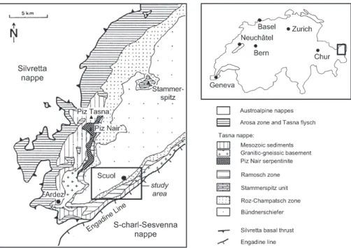
Fig. 1. Geological sketch of the Lower Engadine tectonic window (after Florineth & Froitzheim 1994).
• Proposing an improved conceptual model of regional CO2 production and water circulation, to better understand both the springs and the CO2exhalations;
• Determining whether or not there is a regional CO2 anom-aly in the area, i.e. if the CO2exhalations are restricted to a limited number of mofettes or fault zones or if important quantities of this gas escape diffusely through the soil on larger surfaces;
• Identifying possible locations to drill a new coldwater geyser.
The investigation program included the evaluation of data and information from the literature, geological and hydrogeologi-cal mapping, measurement of physicochemihydrogeologi-cal parameters at springs, water sampling and laboratory analyses for major and trace elements, and, above all, CO2and radon gas measure-ments, both in the water and soil gas.
2 Description of the study area and origin of the CO2
2.1 Location, topography and climate
The villages of Scuol and Tarasp are located in the Lower Engadine Valley, the valley of the River Inn, in the Canton of Grisons (GR) in the eastern Swiss Alps. The river flows in a WSW-ENE direction and is at an altitude of 1165 m near Scuol; the highest summits on both sides of the valley exceed 3000 m and are scarcely glaciated. The valley is asymmetric with much steeper slopes on the southern (right) than on the northern (left) side. The Engadine Valley is characterised by a relatively dry and cool alpine climate. The average annual pre-cipitation at Scuol is 795 mm, much less than in most other parts of the Alps, and the average annual air temperature is 5 °C.
2.2 Geological framework
In the Lower Engadine Valley, the Austroalpine nappes are re-gionally eroded so that the Penninic nappes are exposed,
form-ing a large tectonic window (Fig. 1). The Engadine Window is 54 km long (SW-NE) and up to 17 km wide (SE-NW). The highest tectonic units are the Upper Austroalpine S-charl-Sesvenna and Silvretta nappes, which consist of a crystalline basement with parautochthonous sedimentary cover. These two nappes form the framework of the tectonic window. The Lower Penninic Bündnerschiefer (schistes lustrés) is the lowest tectonic unit and outcrops inside the window. The formation consists of metamorphosed, dominantly pelagic rocks, including grey and black shale, as well as sandy and calcareous phyllites. The Lower Engadine Mélange between the Penninic and Aus-troalpine nappes includes the Roz-Champatsch zone, the Tasna nappe with its Mesozoic sediments and crystalline basement, and the ophiolites and crystalline basement of the Ramosch zone (Cadisch et al. 1968; Florineth & Froitzheim 1994).
The structural reason for the tectonic window is an impor-tant regional uplift, which mainly occurred along a major fault at the SE margin of the window, the Engadine Line. This fault was active in the late Tertiary, after the main phase of alpine collision. It is a left-lateral extensional strike-slip fault (transtension) with a vertical displacement of about 6 km (Schmid & Froitzheim 1993). Regional uplift also formed a huge anticlinorium, which cumulates in the centre of the win-dow. Its axis trends SW-NE and coincides with the axis of the tectonic window. In the area of Scuol-Tarasp, the anticlinori-um is represented by an anticline; most of the carbogaseous mineral springs are located in this zone.
2.3 Hydrogeological framework
Based on lithological and hydrological field observations, Bis-sig (1997) defined seven major hydrogeological units in the study area (Tab. 1).
Most of the carbogaseous mineral springs discharge from the Bündnerschiefer fractured aquifer (unit 1), either directly or indirectly via overlying sediments (unit 7). In order to better characterise regional groundwater flow, Bissig (1997) carried out a fracturing study, which focused on the main aquifer but Tab. 1. Hydrogeological units in the study area.
1The springs were attributed to the main
hydroge-ological unit forming their catchment basin; the numbers in brackets refer to the number of springs that discharge via unconsolidated sedi-ments. * No detailed investigations were made for this study.
also included a gneiss outcrop. It was possible to identify 8 families of joints, including release and shear joints, and 3 fam-ilies of faults. Although there are no precise data on hydraulic fracture properties, such as aperture, connectivity or infillings, it was possible to demonstrate the importance of the joint pat-tern for groundwater flow and surface hydrology. Both the river network and geomorphological lineaments reflect the joint pattern. Mineral springs are often located at the intersec-tion of such lines.
2.4 Origin of the CO2
Wexsteen et al. (1988) analysed the gas in selected mofettes and carbogaseous springs near Scuol-Tarasp in order to deter-mine its origin. The gas is composed of CO2(> 93 %), N2(5–7 %), He (5 ppm) and traces of H2S (1 ppm). The gas composi-tion in the spring waters and mofettes is similar, suggesting that it has the same source. The 13C/12C and 3He/4He ratios in-dicate that the CO2originates from metamorphic reactions in the crust, while a mantle source can be excluded. During ther-mo-metamorphosis, CO2forms at 300–400 °C by the decompo-sition of carbonate minerals (Bucher & Frey 2002). For exam-ple, dolomite reacts with quartz to form talc, calcite and car-bon dioxide:
3 CaMg(CO3)2+ 4 SiO2+ H2O = Mg3(OH)2Si4O10+ 3 CaCO3 + 3 CO2
While calcite reacts with quartz to form wollastonite and carbon dioxide:
CaCO3+ SiO2= CaSiO3+ CO2
3 Methods
3.1 Hydrochemical analyses
The water temperature (T), electrical conductivity (EC), pH and oxygen content (O2) were measured at the springs using standard field instruments. The discharge (Q) was quantified using receptacles and a stopwatch, or estimated where this was not possible (Bissig 1997). Water samples were taken at all springs. The Cantonal Laboratory of Grisons measured the major water constituents using ion chromatography (DIONEX DX-120). The trace elements were analysed at the Institute of Geology and Hydrogeology (IGH) at the University of Neuchâtel by means of ICP-MS (Mayoraz 2004).
3.2 CO2and radon measurements in water
Bissig (1997) used a simple field method to estimate the CO2 content in the spring waters, the ‘Karat’ tube. Mayoraz (2004) reinvestigated most of the spring waters in the study area. At each spring, two samples, one for CO2 and one for radon, were taken in 20 mL Teflon lined silicone septum vials with no air bubbles left. The samples were analysed at the Envi-ronmental Radioactivity Laboratory at the CHYN within one week.
For the CO2measurement, air is bubbled in a closed circuit for 3 min at 200 mL/min through the sample. The CO2 concen-tration in the air circuit is then measured by IR absorption (Texas Instruments CO2Sensor 9GS-1-5-ZC). The initial
con-Fig. 2. Map of the springs in the region of Scuol-Tarasp. The location of the study area is shown in Fig. 1 and the shorthand symbols are defined in Tab. 2. The numbers at the margins represent the Swiss Topographic Grid (unit: metres).
centration in the sample is calculated using the known air/water volume ratio and the Bunsen coefficient. Measure-ments are reproducible within ± 2 mg/L. Calibration uncertain-ty of the sensor is estimated to be ± 20 %.
Radon (222Rn) is measured by liquid scintillation counting: 10 mL of the water sample are added to 10 mL scintillator (Maxilight, Perkin Elmer). After a 3h delay, 7 mL of the scin-tillator are extracted and counted for 1000 s (Triathler, Hidex Oy, Finland, in alpha/beta separation mode). The detection limit is 0.3 Bq/L and the calibration uncertainty is < 5 %.
3.3 CO2and radon measurements in the soil gas
Mayoraz (2004) measured the CO2and radon concentration in the soil gas using a procedure proposed by Surbeck (1993): A hole is drilled manually to a depth of 30–50 cm using a 7 cm soil auger. A probe with an inflatable packer is
intro-duced and fixed by pumping up the packer. The soil gas is sucked for 5 min at 1 L/min. The gas then passes through a 222Rn monitor (RAD7, Durridge, Bedford, MA, batch mode) and a CO2detector (Texas Instruments CO2 Sensor 9GS-1-5-ZC). The CO2detector has a full range of 25 vol.%. Readings are reproducible within ± 0.2 vol.% and calibration uncer-tainty is estimated to be ± 20 % (1-sigma) for the full range. At typical values of several kBq/m3, the radon monitor has a counting statistics uncertainty of ± 10 % (1-sigma). The calibration uncertainty given by the manufacturer is ± 2 % (1-sigma). A pressure gauge is connected to the tube leading from the soil gas probe to the pump (RAD7 internal pump). This allows for an estimation of the soil’s gas permeability. However, no noticeable differences in the pressure have been observed for all the samples taken during this study. There-fore, the pressure readings were not used to normalise the radon and CO2data.
4 Carbogaseous springs and geysers
4.1 Overview
16 carbogaseous springs (> 500 mg CO2/L), two formerly ac-tive carbogaseous geysers, and 23 other springs in the region of Scuol-Tarasp were observed and sampled (Fig. 2, Tab. 2). All carbogaseous waters discharge from the Bündnerschiefer fractured aquifer and are characterised by low temperatures (< 12.5 °C), a mineralisation of more than 1000 mg total dis-solved solids (TDS) per litre, and CO2content that often ex-ceed 2000 mg/L. The highest mineralised springs (> 5000 mg TDS/L) are situated along the River Inn. The springs at the northern slope of the valley often show intermediate minerali-sation. Only two mineral water springs with relatively low CO2 content occur at the southern slope.
4.2 Origin and functioning of the coldwater geysers
Normal geysers blow out hot water fountains when the heat of the rock brings the water near boiling. The pressure release during the eruption increases the steam production, which re-inforces the eruption (Rinehart 1980). Most coldwater geysers are manmade phenomena, which may occur when a borehole is drilled into a carbogaseous aquifer. Liberation of CO2from the over-saturated water causes the eruption, and the pressure release increases the degassing. Both hot and cold geyser erup-tions are thus self-amplifying processes, and the formation of gas bubbles is essential for the generation of eruptions. Glen-non & Pfaff (2005) provide an overview of coldwater geysers. The world’s largest one is located near Andernach in Ger-many. It was first created by a drilling in 1905, then destroyed due to road construction and reactivated in 2001 by a 350-m drilling. This geyser ejected 60-m-high fountains every 90 min. Soon after the drilling, the borehole had to be closed because
there was unwarranted concern that the geyser could harm the environment (pers. communic. B. Krauthausen). Up to 30-m-high water and gas eruptions also occurred at a 1600-m-deep geothermal exploration borehole, which was drilled in 1991 in the Upper Engadine Valley (Aemissegger 1993).
The coldwater geysers in the region of Scuol-Tarasp were created by two 100-m-deep mineral water exploration wells. Geyser I was destroyed in 1934 during excavation works; how-ever, the water can still be sampled. Geyser II is partly filled with sediments, and is blocked at 14 m depth. Only a few, small eruptions (< 2 m) have been observed since 1961.
Bissig (1997) investigated the geysers, including hydrochemi-cal analyses (section 4.4) and recording of their hydrodynamic behaviour. The mean water level in the borehole of Geyser II is at 5.5–6.0 m below wellhead, i.e. 0.5–1.0 m above the level of the near River Inn (Fig. 3). The water level in the borehole was ob-served from July to October 1997 using a dip-meter for occasion-al measurements and a continuously recording pressure probe at 13 m below wellhead. This probe often showed lower water depths than the dip-meter, which can be explained by variable content of gas bubbles. The pressure data thus cannot be directly transformed into water-level data. During the first two months, the pressure recordings display stagnation periods that may last up to 7 days and short fluctuation phases. The fluctuations may exceed 0.1 bar in 10 min, i.e. more than 1 m of water-level varia-tion. During the last month, the borehole showed permanent variations without stagnation periods, indicating that Geyser II is still active, although the borehole is in disrepair.
4.3 CO2and radon in the spring water
The available data on CO2 in spring water for the region of Scuol-Tarasp (Mayoraz 2004, Deflorin 2004, a total of 38 sam-ples) show a frequency distribution, which can be well fitted Fig. 3. Schematic illustration of Geyser II and the hydrodynamic behaviour observed in the borehole.
using a two-component approximation Fig. 4. Component 1 with a median of 2200 mg/L is attributed to geogenetic production, whereas component 2 with a median of 24 mg/L shows a distrib-ution expected for groundwater in equilibrium with the soil.
The data on radon in spring water (Mayoraz 2004; Deflorin 2004; a total of 32 samples) display a nearly perfect one-com-ponent lognormal distribution with a median of 5 Bq/L (not presented here). This corresponds to the median found by Deflorin (2004) for 360 samples taken in the Canton of Grisons. There is a deviation from the one-component behav-iour at values above 20 Bq/L, with the highest value at 25 Bq/L. The origin of this second component is unknown, but there is no need to attribute it to radon upwelling with the CO2from depth. 25 Bq/L are still within the range for groundwater in contact with soil. Furthermore, there is no correlation between the concentrations of the two gases for the 18 water samples, for which both radon and CO2are known.
4.4 Hydrochemical classification of the spring and geyser waters
On the basis of the major-ion chemistry, the hydrogeological units and the location of the springs and geysers, it is possible to distinguish six groups of water types with various sub-groups, and two special water types (Tab. 2). The water chem-istry of one characteristic spring from each group is shown in the SCHOELLERdiagram in Fig. 5; a detailed description of the spring groups is given in the following sections.
Group 1
The most famous carbogaseous mineral springs are situated along the gorge of the River Inn and discharge from the Bünd-nerschiefer formation. Luzius and Emerita are Switzerland’s highest mineralised springs, with 15500–17700 mg TDS/L.
These two springs, as well as Sfondraz and the geysers belong to the Na-HCO3-Cl water type, which can further be classified according to the Ca2+ and Cl-content (Tab. 2). Besides the standard major cations and anions, the mineral water also con-tains significant amounts of H2S, boron acid, Li+and various trace elements. The CO2concentrations are within a range of 2200–2600 mg/L.
Group 2
Other carbogaseous mineral springs in the gorges of the River Inn are characterised by less highly mineralised water (1200–5800 mg TDS/L) with Ca2+as the predominant cation and bicarbonate as the most important anion. The CO2content range from 1200 to 2900 mg/L. Hydrochemically, the spring wa-ters can be considered as a result of mixing between groups 1 and 3. The Carola spring receives an additional contribution from the alluvial aquifer near the River Inn, which contains sul-phate. About 3000 bottles of water from this spring are used each year for local hotels (pers. communic. R. Zollinger). Group 3
These springs are located at the slope of Scuol and also dis-charge from the Bündnerschiefer formation. The spring waters Fig. 4. CO2in spring water frequency distribution and approximation by a
2-component model. Component 1: geogenetic production; 2-component 2: distri-bution to be expected for groundwater in equilibrium with the soil. Error bars are 1-sigma uncertainty estimations.
Fig. 5. SCHOELLERdiagram of characteristic springs from the different hydro-chemical groups.
show low to medium mineralisation (700–3100 mg TDS/L) and a simple Ca-HCO3chemistry. Iron and silicic acid are impor-tant minor water constituents at some springs. Most springs of this group are carbogaseous and contain more than 1000 mg CO2/L. Tritium data (Högl 1980; Wexsteen et al. 1988) from some of these spring waters indicate relatively short residence time of less than 5 years.
Group 4
Low mineralised springs (TDS < 1000 mg/L) with a Ca-Mg-HCO3water type occur on both sides of the valley and most often discharge from the Bündnerschiefer formation; either di-rectly or indidi-rectly via an overlying shallow porous aquifer. The CO2content is most often < 60 mg/L, except for the S-Chürdüna spring with 350 mg/L.
Group 5
This group summarises springs that discharge from different hydrogeological units at the southern slope of the valley, which are characterised by higher sulphate than bicarbonate concen-trations. The mineralisation of the spring waters is low to medium (800–1700 mg TDS/L) and the CO2content is always low (< 40 mg/L).
Group 6
This is another heterogeneous group of non-carbogaseous low mineralised springs, which are mainly situated at the southern valley slope and discharge from different aquifers, often indi-rectly via shallow porous aquifers. Unlike the springs of group 5, the waters of this group show higher bicarbonate than sul-phate content (Ca-Mg-HCO3-SO4water type).
Special water types (groups 7 and 8)
Two springs in the region show special hydrochemical charac-teristics that differ from the six other groups. The Lischana spring is a highly mineralised carbogaseous spring that was captured by a drilling in serpentinite near the River Inn. It is the only spring in the region that contains more magnesium than calcium. The major element composition is Na-Mg-HCO3-SO4. The water also contains high concentrations of boron and silicic acid.
The ‘Tarasper Schwefelquelle’ (sulphur spring) also dis-charges from serpentinite but has low mineralisation. The characteristics of this spring are very different from those of the Lischana spring because it contains no CO2. As already ob-served by Pfeifer (1977), the water is strongly basic with a pH of about 11, which is typical for groundwater in ultramafic rocks. As a consequence of the high pH, inorganic carbon is present as carbonate (CO32-). The geochemical water type is Ca-Na-CO3-Cl-SO4.
5 Mofettes and soil gas
5.1 Mofettes
On the northern slope of the valley, near Scuol, there are long-known spots of dry gas exhalations, which are called ‘mofettes’ in analogy to the volcanic phenomena. The largest one is known as ‘Mofetta Felix’. As described above, the gas is main-ly composed of CO2(> 93 %) but also contains other compo-nents, including traces of H2S. Such high CO2concentrations are harmful. The mofettes can thus be recognised due to re-duced vegetation, accumulations of dead insects and a slight smell of hydrogen sulphide (Schmassmann 1980).
All mofettes discharge from moraine overlying the Bünd-nerschiefer formation. Geophysical investigations (VLF-R) showed that the thickness of the moraine ranges between 15 and 20 m (Wexsteen & Müller 1987). In the zone of the Mofetta Felix, the gas outlets are aligned in a N60 direction, sub-parallel to the axis of the valley and the crest of the anti-cline. The geophysical investigations indicate conductive zones in a N150 direction, perpendicular to the mofette line. Those were interpreted as open fractures with diaclases allow-ing for degassallow-ing from depth. A second zone of mofettes is lo-cated nearby above the Vih spring and seems to follow a N100 direction.
5.2 CO2and radon in the soil gas
It was previously not known if the mofettes reflect an important regional CO2anomaly or if there are only a limited number of point-like gas outlets. Therefore, Mayoraz (2004) measured the CO2concentration in the soil gas along 7 profiles following a NW-SE direction, i.e. perpendicular to the mofette lines and structural axes, and 2 NE-SW profiles. The radon (222Rn) con-centrations were measured simultaneously. The main profile is 3745 m long, while the other profiles range in lengths between 45 and 518 m. The mean distances between the measurement points is 72 m for the main profile and 6–34 m for the others, and the number of points per profile is 53 for the main profile and 6–27 for the others. Furthermore, the gas concentrations in the soil gas were measured in the near environment of the car-bogaseous springs and geysers. Altogether, the soil gas concen-trations were measured in 178 boreholes along 5454 m of total profile length. The results are presented in Fig. 6.
The CO2measurements confirmed the long-known zones of gas exhalations, i.e. the mofettes near Scuol. Outside from these zones, the concentrations are often within a range of 0.2–2 vol.% – normal values for soil gas. Near the Mofetta Felix, increased concentrations (> 4 %) were detected in a 100-m-wide zone. Similarly, an 80-100-m-wide anomaly was detected in the mofette zone northerly uphill from the carbogaseous Vih spring. Locally, the range of the instrument (25 %) was ex-ceeded. The 3745-m-long main profile only showed one small CO2anomaly, NW uphill from the Vih spring. Two detailed profiles, NW-SE and NE-SW, made it possible to better
de-fine this anomaly, which is about 20 m x 20 m in size with a maximum concentration of 5.3 % CO2.
The soil gas measurements near the carbogaseous springs and geysers most often showed CO2content of 0.2–2 %. High-er values wHigh-ere detected near two springs, Sfondraz and Rablönch. The near environment of the latter was investigated along two perpendicular profiles. Increased values were found in a zone of 50 m (NW-SE) x 40 m (NE-SW). The highest value, locally > 25 vol.%, were found 55 m uphill from the spring.
The radon concentrations in the soil gas range between less than 0.2 and 35 ± 3 Bq/L. Although high CO2content (> 10 %) always coincide with elevated radon content (> 1.5 Bq/L), there is no systematic correlation between the two gases.
The frequency distribution of the CO2concentrations in the soil can be approximated by two lognormal components
(Fig. 7). About 70 % of all measured values can be attributed to CO2production in the soil, which confirms that there is no general regional CO2anomaly.
The 222Rn in soil gas frequency distribution shows no indi-cation for radon from depth (Fig. 8). 90 % of all values can be explained by radon produced in the soil, with a median of 2 kBq/m3. A second component with a median of 0.5 kBq/m3 may be due to leaky sampling.
6 Discussion and conclusions
6.1 Conceptual model of the regional gas and groundwater circulation
The previous isotopic studies showed that the CO2 in the Lower Engadine originates from the metamorphosis of car-Fig. 6. Spatial distribution of the CO2
concentra-tions in the region of Scuol-Tarasp (below) and in three zones that were investigated in great detail (above). The highest values were found near the known mofette zones (Felix and Vih) and some carbogaseous springs (Rab, Sfo, Vih). Apart from these small zones, no significant anomalies were detected, also not in the geyser field. The num-bers at the margins represent the Swiss Topo-graphic Grid (unit: km).
bonate rocks in the crust (Wexsteen et al. 1988). The results of the study presented in this paper made it possible to propose an improved conceptual model of the regional gas and water circulation (Fig. 9), and to better understand the relations be-tween dry gas exhalations, carbogaseous mineral springs, and freshwater springs (Fig. 10).
Almost all carbogaseous phenomena are bound to the Bündnerschiefer fractured aquifer (unit 1 in Tab. 1). The tec-tonically higher hydrogeological units 2 and 3 act as a regional aquiclude limiting both groundwater and gas circulation. The River Inn forms the regional hydrological base level. Steep hy-draulic gradients have to be expected in the fractured shale of the Bündnerschiefer formation so that the piezometric surface is high above the river on both sides of the valley. Below this level, all voids in the rock are fully saturated with water. It is thus clear that the CO2rises up from depth along water-satu-rated fractures, dissolved in the groundwater. Dry gas move-ment can only occur at shallow depth in the unsaturated zone. High CO2content in the groundwater favour both the dissolu-tion of carbonate minerals and the transformadissolu-tion of silicate minerals (Krauskopf & Bird 1995), for example:
CaCO3+ CO2+ H2O = Ca2++ 2 HCO3
-2 Na[AlSi3O8] + 2 CO2+ 3 H2O = Al2[(OH)4/Si2O5] + 4 SiO2+ 2 HCO3-+ 2 Na+
Consequently, high CO2 content causes high mineralisa-tion. As the solubility of gas in water decreases with decreasing pressure, the carbogaseous fluids become over-saturated with gas when they rise up from depth. Near the River Inn, de-gassing of CO2and mineral precipitation can be observed at the springs. The soil gas measurement near these springs and the geysers displayed no significant CO2anomalies (exception:
Sfondraz spring). This finding suggests that the degassing oc-curs directly at the outlet points of the springs and geysers.
On the northern slope of the valley, above the regional hy-drologic base level, there is an important unsaturated zone, and thick moraines locally overlay the fractured aquifer. In this zone, degassing takes place near the groundwater surface, probably tens of metres below the land surface within the moraine. The long-known mofette zones are located in this area, and the soil gas measurements allowed the identification of two formerly unknown CO2 anomalies uphill near the Rablönch and Vih carbogaseous mineral spring. These anom-alies are tens of metres in size. The CO2content at some points exceed the measurement range of 25 %. The dry gas exhala-tions upgradient from the springs indicate the upwelling of car-bogaseous water along fractures in the shale. In the moraine, a part of the CO2separates from the fluids and rises up through the unsaturated zone, while the carbogaseous mineral water mixes with fresh groundwater and flows laterally downwards to the springs (Fig. 10). Outside from these spatially restricted mofettes and anomalies, most of the 178 measurements gave CO2content of 0.2–2 vol.%, which is within the normal range for soil gas. The dry gas exhalations are thus locally restricted phenomena, which are, however, often aligned in a N60 or N150 direction.
Although all carbogaseous mineral springs, except one, dis-charge from the same aquifer, their hydrochemical characteris-tics are quite different and can only be understood within a wider hydrogeological framework. Natural tracers, i.e. the chemical and isotopic water composition, have been used to classify the spring waters and to obtain information on the groundwater circulation system. As described above, there are Fig. 7. CO2in soil gas frequency distribution and approximation by a
2-com-ponent model. Com2-com-ponent 2: CO2production in the soil; component 1:
geoge-netic production. Maximum measured values are limited to 25 vol.%, the full scale of the instrument used. Error bars are 1-σ uncertainty estimations.
Fig. 8. 222Rn in soil gas frequency distribution and approximation by a
2-com-ponent model. Com2-com-ponent 1: typical radon production in an average Swiss soil. There is no need for any radon from deep down to explain the distribu-tion. Component 2 with a lower median and a broader distribution may be due to leaky sampling. Error bars are 1-sigma counting statistics.
six main hydrochemical groups of spring waters and two spe-cial water types (Tab. 2). Groups 1 to 3 are carbogaseous min-eral waters that discharge from the Bündnerschiefer fractured aquifer, either directly or via overlying sediments. In a first ap-proach, the different water types within these three groups can be explained by mixing of up to three main components: 1. Extremely mineralised Na-HCO3-Cl water (Luzius and
Emerita);
2. Highly mineralised Ca-HCO3 water (Runa, Vih, Sotsass and Rablönch);
3. Fresh groundwater.
The origin of the Na-HCO3-Cl water (comp. 1) is still debat-able. Tritium data indicate that it is older than 32 years (Wexs-teen 1988). The high content of Na+, Cl-and minor elements, like Li+and boron acid, cannot be derived from the Bündner-schiefer formation. These elements may originate from the dis-solution of evaporitic rocks. Such formations have not been proven in the region. However, deep geophysical profiles across the Alps indicate the possible presence of evaporitic layers beyond the 10 km depth, within the sedimentary cover of the South Helvetic and North Penninic basement (Pfiffner et al. 1997). It is also possible that slices of Triassic evaporites occur in the hanging wall of the Bündnerschiefer formation at shallower depths. The radiocarbon method cannot be used for
water dating, as the CO2is of metamorphic origin. Stable iso-tope data deviate from the meteoric water line. The water is enriched in 18O, which may indicate water-rock interaction at more than 150°C (Schotterer et al. 1987; Wexsteen 1988). As the Bündnerschiefer consists of metamorphic marine sedi-ments, the saline water could also originate from ancient ma-rine formation waters, which is consistent with the deviation from the meteoric line (Högl 1980; Wexteen 1988). Up until now, the different hypotheses could neither be confirmed nor disproved.
According to Siegenthaler (in Högl 1980), the mean resi-dence time of the highly mineralised Ca-HCO3water from the Vih and Sotsass springs (comp. 2) is less than 5 years. Wexs-teen (1988) proposed that the spring water results from mixing of fresh groundwater with 5–50 % of very old components so that exact dating is not possible.
The fresh groundwater (comp. 3) includes a variety of dif-ferent water types, which reflect the difdif-ferent hydrogeological units (Tab. 1). Groundwater from the Bündnerschiefer aquifer (unit 1) and the moraine (unit 7) predominantly contains Ca2+, Mg2+and HCO3-. Springs that discharge from the hydrogeo-logical units 4 and 6 additionally contain sulphate.
The less mineralised waters within group 3 can be ex-plained by mixing of highly mineralised Ca-HCO3 water (comp. 2) and fresh groundwater (comp. 3). The highly miner-Fig. 9. Conceptual model of the CO2and
alised waters of group 2 (Bonifazius, Fuschana) can be consid-ered as mixtures of components 1 and 2; the Carola spring ad-ditionally includes a significant contribution of fresh ground-water.
The low spring temperatures seem to contradict a deep ori-gin of the carbogaseous mineral water. However, the discharge rates of the mineral springs are very low (Tab. 2). Due to the low flow rates and velocities, the hot mineral waters rising from depth have enough time and contact with the rock mass to cool.
6.2 Hydrochemical criteria to localise a new geyser drilling
The abovementioned coldwater geyser in Andernach yielded 60-m-high eruptions from a 350-m-deep borehole. The fact that the geysers near Scuol-Tarasp produced 10-m-high foun-tains, although the boreholes were only 100 m deep, suggests that there is potential for higher fountains if a deeper borehole was drilled at the right place. The observations described in this paper indicate that Geyser II is still active, although its functioning is strongly reduced as the borehole is partly filled with sediments and blocked at 14 m depth.
The short-term functioning of a coldwater geyser depends on two major aspects: inflow of groundwater from a
sufficient-ly transmissive aquifer, and inflow of CO2from depth. How-ever, high CO2 content often coincide with high mineralisa-tion, and the mineral precipitation from the fluid phase is like-ly to clog the borehole. The long-term functioning thus addi-tionally requires a relatively low mineralisation. Fig. 11 pre-sents the CO2 concentration and total mineralisation of all spring and geyser waters in the region of Scuol-Tarasp. Ideal conditions to drill a new coldwater geyser should be present when the water is rich in CO2while mineralisation is low, i.e. within group (a).
Acknowledgements
The Forum Vulpera/Tarasp financially supported this study. The authors are grateful to Rolf Zollinger for his friendly support and much valuable in-formation. During our fieldwork, we stayed free of charge in his excellent Hotel Villa Post, which made this project highly agreeable. We thank the Cantonal Laboratory of Grisons for the chemical analyses and Dr. Virginie Matera (IGUN, Neuchâtel) for the ICP-MS analyses. We thank our former collaborator Dr. Jérôme Perrin who contributed to the soil drilling works during his civil service. We are grateful to all local authorities and private persons who helped us in various ways. We thank Dr. Ottmar Deflorin for the “Resumaziun” in Rhaeto-Romanian, and Alan Glennon for the proof-reading.
Fig. 10. Schematic illustration of the relation between dry CO2exhalations
and carbogaseous springs.
Fig. 11. According to their CO2concentration and mineralisation (TDS), the
springs in the region of Scuol-Tarasp can be classified into three groups: (a) high CO2and low to medium TDS, (b) high CO2and high TDS, (c) low to
REFERENCES
AEMISSEGGER, B. 1993: Geothermie-Bohrung Pro San Gian, St. Moritz. Bul-letin der Vereinigung Schweizerischer Petroleum-Geologen und -Inge-nieure 60, 136, 1–18.
BARNES, I., IRWIN, W.P. & WHITE, D.E. 1978: Global distribution of carbon dioxide discharges, and major zones of seismicity. USGS, Water-resources invest. 78–79, open-file report, 12 p.
BATTANI, A., SARDA, P. & PRINZHOFER, A. 2000: Basin scale natural gas source, migration and trapping traced by noble gases and major elements: the Pakistan Indus basin. Earth and Planetary Science Letters 181(1–2), 229–249.
BISSIG, P. 1997: Hydrogeologische Untersuchung der CO2-reichen
Miner-alquellen von Scuol-Tarasp (GR, Schweiz). Dipl. thesis CHYN, 90 p. Bucher, K., Frey, M. 2002: Petrogenesis of Metamorphic Rocks. 7th ed.,
Springer-Verlag, Heidelberg., 341 p.
BUTALA, S.J.M., MEDINA, J.C., TAYLOR, T.Q., BARTHOLOMEW, C.H. & LEE, M.L. 2000: Mechanisms and kinetics of reactions leading to natural gas formation during coal maturation. Energy & Fuels 14(2), 235–259. CADISCH, J., EUGSTER, H. & WENK, E. 1968: Geologischer Atlas der Schweiz
1:25.000, Scuol-Schuls/Tarasp, Blatt 44, Erläuterungen. Schweiz. Geol. Kommission.
DEFLORIN, O. 2004: Natürliche Radionuklide in Grundwässern des Kantons Graubünden, PhD thesis CHYN, 188 p.
DERRY, L.A., EVANS, M.J. & FRANCE-LANORD, C. 2002: Tracing hydrothermal and metamorphic fluxes of CO2and solutes from the central Himalaya.
Geochimica et Cosmochimica Acta 66(15A), A178–A178.
DILIBERTO, I.S., GURRIERI, S. & VALENZA, M. 2002: Relationships between diffuse CO2emissions and volcanic activity on the island of Vulcano
(Ae-olian Islands, Italy) during the period 1984–1994. Bulletin of Volcanology 64(3–4), 219–228.
FLORINETH, D. & FROITZHEIM, N. 1994: Transition from continental to ocean-ic basement in the Tasna nappe (Engadine window, Graubünden, Switzer-land): evidence for Early Cretaceous opening of the Valais ocean. Schweiz. Mineral. Petrogr. Mitt. 74, 437–448.
GIAMMANCO, S., GURRIERI, S. & VALENZA, M. 1995: Soil CO2Degassing on
Mt-Etna (Sicily) During the Period 1989–1993. Discrimination between Climatic and Volcanic Influences. Bulletin of Volcanology 57(1), 52–60. GLENNON, J.A. & PFAFF, R.M. 2005: The operation and geography of
carbon-dioxide-driven, cold-water geysers. GOSA Transactions 9, 184–192. GRANIERI, D., CHIODINI, G., MARZOCCHI, W. & AVINO, R. 2003: Continuous
monitoring of CO2soil diffuse degassing at Phlegraean Fields (Italy):
in-fluence of environmental and volcanic parameters. Earth and Planetary Science Letters 212(1–2), 167–179.
HARTMANN, A. 1927: Die Entstehung der Mineralquellen Tarasp-Schuls und der andern Bündner Säuerlinge. Sonderabdruck Vierteljahrsschrift Natf. Ges. Zürich 72, 237–290.
HÖGL, O. 1980: Die Mineral- und Heilquellen der Schweiz. Verlag Paul Haupt, Bern und Stuttgart, 302 p.
KERRICK, D.M. 2001: Present and past nonanthropogenic CO2degassing from
the solid Earth. Reviews of Geophysics 39(4), 565–585.
KERRICK, D.M. & CALDEIRA, K. 1998: Metamorphic CO2degassing from
oro-genic belts. Chemical Geology 145(3–4), 213–232.
KRAUSKOPF, K.B. & BIRD, D.K. 1995: Introduction to geochemistry. McGraw-Hill, New York, 647 p.
MARTY, B., O’NIONS, R.K., OXBURGH, E.R., MARTEL, D. & LOMBARDI, S. 1992: Helium isotopes in Alpine regions. Tectonophysics 206, 71–78. MAYORAZ, J. 2004: Le CO2dans le sous-sol et dans les eaux de la région de
Scuol-Tarasp (Grisons). Dipl. thesis CHYN, 34 p.
NESBITT, B.E., MENDOZA, C.A. & KERRICK, D.M. 1995: Surface field convec-tion during Cordilleran extension and the generaconvec-tion of metamorphic CO2contributions to Cenozoic atmospheres. Geology 23(2), 99–101.
NUSSBERGER, G. 1914: Heilquellen und Bäder im Kanton Graubünden. Verkehrsverein von Graubünden, Chur.
NUSSBERGER, G. 1899: Ueber die Entstehung bündnerischer Mineralquellen. Jahresber. Natf. Ges. Graubünden 42, 1–35.
PFEIFER, H.-R. 1977: A model for fluids in metamorphosed ultramafic rocks. Observations at surface and subsurface conditions (high pH spring wa-ters). Schweiz. mineral. petrogr. Mitt. 57, 361–396.
PFIFFNER, O.A., LEHNER, P., HEITZMANN, P., MUELLER, S. & STECKA. 1997: Deep structure of the Swiss Alps. Results of NRP 20. Birkhäuser Verlag, Basel, 380 p.
RINEHART, J.S. 1980: Geysers and geothermal energy. Springer-Verlag, New York, 223 p.
SATO, M., MORI, T., SHIMOIKE, Y., NAGAO, K. & NOTSU, K. 2002: Carbon iso-tope systematics of CO2, CO and CH4in fumarolic gases from
Satsuma-Iwojima volcanic island, Japan. Earth Planets and Space, 54(3): 257–263. SCHMASSMANN, H. 1980: Geologie und Genese der schweizerischen
Mineral-und Thermalwässer. In: Högl (ed.), Die Mineral- Mineral-und Heilquellen der Schweiz. Verlag Paul Haupt, Bern und Stuttgart, 47–100.
SCHMID, S.M. & FROITZHEIM, N. 1993: Oblique slip and block rotation along the Engadine Line. Eclogae Geologicae Helvetiae 86/2, 569–593. SCHOTTERER, U., SIEGENTHALER, U., OESCHGER, H., RIESEN, T., MÜLLER, I. &
KELTS, K. 1987: Isotope geochemistry of the Engadine mineral springs of Scuol-Tarasp, Switzerland. Proc. int. symp. isot. tech. water resour. dev., IAEA, Vienna, 277–286.
SEWARD, T.M. & KERRICK, D.M. 1996: Hydrothermal CO2emission from the
Taupo Volcanic Zone, New Zealand. Earth and Planetary Science Letters 139(1–2), 105–113.
STECHER, J.T. 1990: Die Mineralquellen von Tarasp – Ein Rückblick. Vita Sana Verlag, Breganzona und Vulpera, 96 p.
SURBECK, H. 1993: Radon monitoring in soils and water. Nuclear Tracks and Radiation Measurements 22(1–4), 463–468.
TARNUZZER, C. & GRUBENMANN, U. 1909: Beiträge zur Geologie des Un-terengadins. Beiträge zur geologischen Karte der Schweiz, Neue Folge 23, 248 p.
VRBA, J. 1996: Thermal mineral water springs in Karlovy Vary. Environmental Geology 27(2), 120–125.
WEISE, S.M., BRAUER, K., KAMPF, H., STRAUCH, G. & KOCH, U. 2001: Trans-port of mantle volatiles through the crust traced by seismically released fluids: a natural experiment in the earthquake swarm area Vogtland/NW Bohemia, Central Europe. Tectonophysics 336(1–4), 137–150.
WEXSTEEN, P. 1988: Hydrogéologie et géochimie des eaux minérales riches en CO2de la région de Scuol-Tarasp (Basse-Engadine, Grisons). Thèse de
doctorat No. 2299, Univ. Genève, 174 p.
WEXSTEEN, P. & MÜLLER, I. 1987: The Very Low Frequency-Resistivity method applied to the study of the mofettes in the Scuol region (Lower-Engadine, Grisons, Switzerland). Archives des Sciences 40(2), 191–205. WERNER, C. & BRANTLEY, S. 2003: CO2emissions from the Yellowstone
vol-canic system. Geochemistry Geophysics Geosystems, an electronic journal of the earth sciences 4(7), article n° 1061, 27 p.
WEXSTEEN, P., JAFFE, F.C. & MAZOR, E. 1988: Geochemistry of cold CO2-rich
springs of the Scuol Tarasp region, Lower Engadine, Swiss-Alps. Journal of Hydrology 104(1–4), 77–92.
Manuscript received July 27, 2005 Revision accepted April 20, 2006 Published Online First August 14, 2006