HAL Id: hal-02555421
https://hal.archives-ouvertes.fr/hal-02555421
Submitted on 27 Apr 2020
HAL is a multi-disciplinary open access
archive for the deposit and dissemination of
sci-entific research documents, whether they are
pub-lished or not. The documents may come from
teaching and research institutions in France or
abroad, or from public or private research centers.
L’archive ouverte pluridisciplinaire HAL, est
destinée au dépôt et à la diffusion de documents
scientifiques de niveau recherche, publiés ou non,
émanant des établissements d’enseignement et de
recherche français ou étrangers, des laboratoires
publics ou privés.
rise in the western Mediterranean
Elodie Brisset, Francesc Burjachs, Bruno Ballesteros Navarro, Javier
Fernández-López
To cite this version:
Elodie Brisset, Francesc Burjachs, Bruno Ballesteros Navarro, Javier Fernández-López.
Socio-ecological adaptation to Early-Holocene sea-level rise in the western Mediterranean. Global and
Planetary Change, Elsevier, 2018, 169, pp.156-167. �10.1016/j.gloplacha.2018.07.016�. �hal-02555421�
Socio-ecological adaptation to Early-Holocene sea-level rise in the western
Mediterranean
Elodie Brisset
a,b,⁎, Francesc Burjachs
a,b,c, Bruno José Ballesteros Navarro
d,
Javier Fernández-López de Pablo
a,baIPHES, Institut Català de Paleoecologia Humana i Evolució Social, Tarragona, Spain bÀrea de Prehistòria, Universitat Rovira i Virgili, Tarragona, Spain
cICREA, Catalan Institution for Research and Advanced Studies, Barcelona, Spain dInstituto Geológico y Minero e España, Valencia, Spain
A R T I C L E I N F O Keywords: Coastal barrier-lagoon Palaeoenvironments Coastal Archaeology Mesolithic Neolithic A B S T R A C T
Consecutively to the global sea-level rise, coastal landscapes significantly changed during the Early Holocene. We explored how coastal mutations have affected ancient human systems in the western Mediterranean. The Pego-Oliva basin (Spain) provides a thick sediment sequence located in proximity to two well-studied Mesolithic and Neolithic archaeological sites. Based on 16 sediment cores, sedimentological analyses,14C dates, and
in-tegration of previous works, we reconstructed the architecture of the sedimentary facies and the chronology of deposition for the last 9500 years. From 9500 to 8200 cal. BP, the stepwise inland migration of the coastline is characterised by the deposition of peat layers at distinct depths indicating four phases of barrier-lagoon systems development. The marine transgression caused the disappearance of the lagoon at 8200 cal. BP, and reached a maximum inland position at 7300 cal. BP. Since 5800 cal. BP, sea-level stabilisation induced coastal prograda-tion and barrier-lagoon system construcprograda-tion. Five marine flooding phases dated at 9500, 9100–9000, 8750–8650, 8450–8200, and 8100–7300 cal. BP match Atlantic meltwater pulses. Comparison to archaeology shows that the long-lasting Mesolithic occupation corresponds to the presence of coastal offering easily ex-ploitable local intertidal resources. In contrast, during the Late Mesolithic, we observe a lagoon contraction and the reduction of lagoon bivalves size arguing for a decrease in resource productivity. This changes in the lagoon ecosystems negatively impacted to Late Mesolithic populations leading to a less intense occupation of this area. Therefore, the 700 years' temporal hiatus between the last hunter-gatherers and thefirst farmers occupying this area is explained by the disappearance of the formerly exploited biotopes because of sea-level rise, a situation that may have been aggravated by coincidence of the 8200 cal. BP climate event. The maximal sea transgression corresponded to a shift from intertidal to infralittoral species between the Impressa/Precardial and the Postcardial Neolithic, indicating a good adaptation to changing environments at that time. However, comparison between Late Mesolithic to Early Neolithic suggests that communities with different cultural baggage have had a different perception of the same environment. By the past perspective, it emphasises that perception of the ecosystem value as a benefit or constraint, and of the risks associated with sea-level rise, relies first on the local and regional scales adaptive capacity of society to global changes.
1. Introduction
Coupled paleoenvironmental and archaeological studies offer long-term perspectives of the resilience of societies to current global changes (Van de Noort, 2011). However, understanding how past humans in-terrelate to the environment further temporal comparisons between climatic, environmental and archaeological archives need to be im-plemented, by accessing the cascading set of socio-ecosystem responses
from the global to the local scale. Following the end of the Last Gla-ciation, the coastal configuration profoundly changed resulting in the global sea-level rise flooding of the Late Pleistocene littoral plains (Shennan et al., 2000; Jakobsson et al., 2017). Sea-level rise was translated into the loss of human settlement areas, reduction of hunting territories, and modification of coastal ecosystems. Opposite views on whether coastal plains have been effectively attractive for prehistoric communities persist (Bailey, 2004). While some authors have proposed
⁎Corresponding author at: IPHES, Institut Català de Paleoecologia Humana i Evolució Social, Tarragona, Spain.
E-mail address:elodie.brisset@gmail.com(E. Brisset).
that Holocene coasts consisted of marginal areas, compared to the hinterland, others have argued for coastal landscapes as an interface between land and sea being places of countless opportunities for early humans (Dupont et al., 2009;Walsh, 2014;Benjamin et al., 2017). In the Mediterranean, marine resources have represented a low but sig-nificant part of the human dietary needs during the Early Holocene (Costa et al., 2003;Goude et al., 2017). However, the interaction be-tween humans and their environments were not restricted to con-sumption purposes. Geomorphological heterogeneity and the associated biotic richness and diversity (Burnett et al., 1998) may have rendered these areas favourable for a large range of activities including shell gathering,fishing, hunting, agriculture and they well as offered easily accessible corridors for human movements (Erlandson, 2001). The issue is to determine to what extent Early to Mid-Holocene changes on coastal biotopes associated to sea-level rise have affected patterns of human exploitation and occupation (Colonese et al., 2011; Mannino et al., 2011;Colonese et al., 2018).
This work focuses on the paleogeographic reconstruction of coastal and human systems in the course of the Mesolithic and the Neolithic in the Pego-Oliva basin (Valencia, Spain). In the Western Mediterranean, recent studies have investigated human-environmental interactions during the prehistoric period (e.g. Dolez et al., 2015; Currás et al., 2017; Fontana et al., 2017; Vacchi et al., 2017;Melis et al., 2018). However, the low preservation of Early Holocene coastal sites as well as the paucity of integrated research programs correlating archaeological and palaeoenvironmental records, have prevented the answering of this question. Pego-Oliva area is a very well-adapted case study site for investigating the relationship between environmental changes and prehistoric socio-economic dynamics. This area provides sedimentary records to identify the coastal evolution from the Middle Pleistocene to the Holocene (Torres et al., 2014). Previous studies based on sedi-mentary and paleontological analyses have established the main trend of the morphogenetic evolution (Dupré et al., 1988;Viñals et al., 1989;
Fumanal et al., 1993a, 1993b;Viñals, 1995;Viñals and Fumanal, 1995;
Ballesteros Navarro et al., 2009), but are insufficient to be compared and contrasted to the human record given the low chronological re-solution. In addition, the interest of this area lies in its proximity to two major archaeological sites. A renewed record has been produced, that includes dated Mesolithic human remains (Gibaja et al., 2015) and shell midden deposits (Fernández-López de Pablo, 2016), isotopic and zooarchaeological reconstructions of dietary patterns (García Guixé et al., 2006; Fernández-López de Pablo and Gabriel, 2016) and the discovery of Early Neolithic occupations containing rich mollusc as-semblages (Esquembre-Bebia et al., 2008;Bernabeu and Martí, 2014), representing the introduction of farming dispersal episodes by seafaring pioneering groups. In this study, wefirst reconstruct the coastal mor-phogenetic evolution during the Early and Middle Holocene; then we compare the sedimentary evolution at Pego-Oliva with other Medi-terranean sedimentary records to evaluate the driving forces (e.g. cli-mate change) behind the Early Holocene relative sea-level changes, and finally, we explore how coastal mutation affected prehistoric settlement and subsistence patterns.
2. Study site
The study area is located in the south of the Valencian gulf in Western Mediterranean (Fig. 1A). This area is characterised by a suc-cession of flat coastal plains occupied by lagoons (e.g. Albufera de Valencia) and marshes, interrupted to the south by sea cliffs (Viñals and Fumanal, 1995). The saltmarsh of Pego-Oliva is separated from sea by an 8 km long and 1.5 km wide sand barrier system parallel to the coastline. Several washover fans passing through the barrier are de-veloped above the marsh. The saltmarsh is fed by two intermittent rivers fed by runoff, karstic springs and the ground-water nappe. The area is artificially drained for agricultural purposes and it is subjected to saline water intrusions resulting in groundwater exploitation
(Ballesteros Navarro et al., 2009). Colluvial glacis (Fig. 1B) developed in the mountain feet are attributed to the Pleistocene (Viñals and Fumanal, 1995). A lower level of colluvial fans is partly developed on the marsh. The catchment is oriented SW-NE, dominated by Upper Cretaceous limestone mountains reaching 700 m a.s.l. The basinfloor consists of Miocene formations (Fig. 1B). A thick Pleistocene sediment sequence is deposited below the sea level (Torres et al., 2014). Bea-chrocks attributed to the Early Holocene have been identified between −25 and 30 m (Fig. 1B) according to the previous stratigraphic corre-lation based on sediment cores and underwater seismic profiles (Somoza and Rey, 1991; Fumanal et al., 1993b; Rey and Fumanal, 1996).
The study area has been successively occupied by Mesolithic and Neolithic human communities during the Early to Mid-Holocene. El Collado is an open-air site that has uncovered a Mesolithic cemetery composed of 14 burials associated with a stratigraphic sequence con-taining lithic, faunal and shellfish assemblages. Several studies have been published on the stratigraphic sequence (Fernández-López de Pablo, 2016), lithic typology (Aparicio, 2014), chronology of the fu-nerary practices (Gibaja et al., 2015), human diet (García Guixé et al., 2006), and exploitation of littoral resources (Fernández-López de Pablo and Gabriel, 2016). The chronological model of El Collado ( Fernández-López de Pablo, 2016) integrates14C dates on human burials with dates from previous and posterior occupation horizons. This site includes two Early Mesolithic phases (level IV: 9830–9550 cal. BP and level II: 9435–8475 cal. BP) and one Late Mesolithic phase (level I: 8510–8390 cal. BP to 8500–8060 cal. BP). Despite an extensive pro-gram of dating, there is no evidence of Late Mesolithic occupation during and after the chronological span of the 8200 cal. BP event, suggesting the end of the human occupations at this time. El Barranquet is an open-air Early Neolithic site comprising two occupational phases (Esquembre-Bebia et al., 2008). Thefirst phase, characterised by Im-pressa/Precardial pottery, has been dated at 7550–7320 cal. BP. Both the ceramic record and the chronology show strong cultural affinities with the impressa Neolithic facies documented in the Ligurian-Pro-vencal arc, associated with thefirst spread of farming in the western Mediterranean (Bernabeu et al., 2009). The second phase (UE 74 and 71) corresponds to the Postcardial Neolithic which is dated in the re-gion at 6800–6000 cal. BP by its decorative style. Preliminary works have provided paleodietary information from malacological assem-blages (Luján Navas, 2016).
3. Material and methods
Six new boreholes were carried out in the Pego-Oliva basin in 2017 using a geotechnical piston corer comprising core segments of 50 cm and a 10 cm core catcher. The core segments were then stored in 60 cm-width boxes in a cold room (2 °C). The borehole locations were acquired by GPS and altitude is reported according to LIDAR data (altimetric accuracy of 0.3 cm) of the Institut Cartogràphic Valencià with mean sea-level as a benchmark (2: N38.87124, W0.04462, 0.89 m; P17-3: N38.86138, W0.05557, 0.67 m; P17-4: N38.85476, W0.06613, 1.86 m; P17-5: N38.85556, W0.07360, 3 m; P17-7: N38.85790, W0.06142, 0.67 m; P17-8: N38.87569, W0.08774, 1.8 m). The lithos-tratigraphy has been described based on colour, texture, grain-size, and presence of macro-remains (plant debris, shells, gravels).
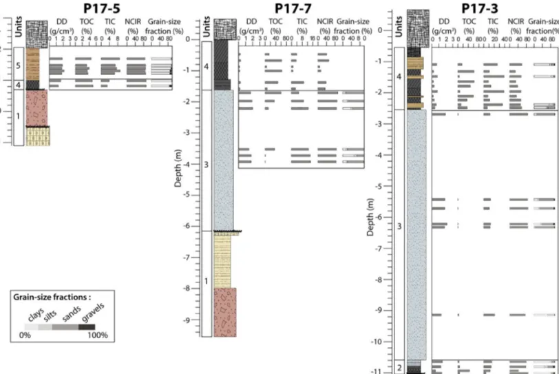
Thirty-nine volumetric samples were obtained from the different sedimentary facies from three representing cores (P17-3, P17-5, and P17-7) and homogenised. A volume of 5 cm3 was dedicated to dry density and loss on ignition analyses. These samples were weighed, dried at 60 °C for 7 days, and weighed again to estimate the dry density. These samples were then ignited at 550 °C for 5 h (Meyers and Teranes, 2001) and weighed to measure the Total Organic Carbon (TOC), and then ignited again at 950 °C for 1 h to estimate the Total Inorganic Carbon (TIC). The remaining ignited fraction corresponds to the Non-Carbonate Inorganic Residue (NCIR). The remaining sample volume
was dried and sieved at meshes of 2 mm, 150μm, and 50 μm for grain-size analysis. Mesh residues were weighed to estimate the percentage of gravel, sand, silt, and clays.
Terrestrial vegetal macro-remains (wood, charcoal, peat stem and
leaves) were manually picked under a binocular microscope and14C dated (Radiocarbon Laboratory of Poznan). The 14C ages were cali-brated in calendar years Before Present (cal. BP) using the Clam R package (Blaauw, 2010) that includes the IntCal13 calibration curves
Fig. 1. A) Localisation of the study area (star) in the western Mediterranean. B) Geological and geomor-phological contexts of the Pego-Oliva wetland. The topographical map is based on LIDAR data of the Institut Cartogràfic Valencià, and the bathymetric map from seismic data of the Cartografià Marine of the Instituto Franklin. C) Location of the boreholes carried out in the basin (green: this study, orange:
Ballesteros Navarro et al., 2009; and blue:Dupré et al., 1988; Viñals et al., 1989; Fumanal et al., 1993a, 1993b) and, of the transects discussed in the manuscript. The seismic profile carried out byViñals and Fumanal (1995)is approximately located on the a’-b’ profile. (For interpretation of the references to colour in thisfigure legend, the reader is referred to the web version of this article.)
(Reimer et al., 2013). Two models have been computed that takes into account the probability density function of the 14C ages and a con-fidence interval of 2σ (10,000 iterations). The age-depth model, cor-responding to the vertical axis, is calculated using a smooth spline function (Supplementary material 1). The age-distance model, corre-sponding to the horizontal axis, is calculated using a linear function (Supplementary material 2).
Ten boreholes previously published have been integrated to this study (Dupré et al., 1988;Viñals et al., 1989;Fumanal et al., 1993b;
Viñals and Fumanal, 1995; Ballesteros Navarro et al., 2009). Sedi-mentological descriptions have been harmonised on the basis of the analysis carried out for this study, and the consultation of the cores PDGEST-2 and PDGEST-7 at the IGME geological samples library (Pe-ñarroya, Spain). Three samples were taken in PDGEST-2 for14C dating. The radiocarbon ages have been re-calibrated using IntCal13 and Marine13. For the marine sample (Glycimeris shell, 6130 ± 100 years BP), an isotopic fractionation (δ13C = 1.14‰) and an average marine reservoir effect (ΔR) of 94 ± 61 years have been accounted for in the study site based on the closestΔR estimates, i.e. Banyuls in France and Castiglione in Algeria (Siani et al., 2000;Reimer et al., 2002).
4. Results
4.1. Geometry of the sedimentary bodies
The sediment cores are characterised by six sedimentary units (Fig. 2). Unit 1, corresponds to the pre-Holocene infilling basin
(Fumanal et al., 1993a;Torres et al., 2014). It consists of colluvial facies
made of a red-brown clay matrix with heterometric coarse gravel that laterally corresponds to a palustrine facies made of light beige silt-clays dominated by calcium carbonates. In discontinuity to Unit 1, the Ho-locene sedimentation starts in Unit 2. Unit 2 consists of decimetre-thick homogeneous black peat facies (Fig. 2) rich in organic matter (TOC = 45%) and Non-Carbonate Inorganic Residues (NCIRs = 43%), having a relatively low density (0.5 g/cm3). Benthic foraminifera are present (Ammonia beccarii) together with Cerastoderma glaucum bivalves that are characteristic of lagoonal environmental conditions influenced by marine waters (Dupré et al., 1988; Torres et al., 2014). Unit 3 is decametre-thick, dominated by a calcium carbonate sand fraction (mean sand value = 60%, Total Inorganic Carbon = 13.5% in a grey-blue clay matrix (29%). TOC is minimal (2%). From bottom to top, increasing proportions in benthic foraminifera (Haynesina germanica and Ammonia beccarii compared to Elphidium excavatum and Ammonia perlucida) suggest a decrease in salinity over this littoral facies, from open-sea to semi-enclosed lagoon environments (Dupré et al., 1988). Unit 4 consists of a decametre-thick homogeneous tofibrous black peat sediments (TOC = 55%) that are developing up to the core surface of several boreholes. Microfossil assemblages are dominated by benthic foraminifera A. beccarii reflecting a lagoon environment, mostly influ-enced by brackish waters subjected to marine intrusion (Dupré et al., 1988). In one borehole, the sedimentary sequence is capped by Unit 5, characterised by dense (1.8 g/cm3) minerogenic clays (NCIR = 88%, clays = 92%). Isolated angular gravels occurred in this unit (maximum of 7%). This facies corresponds to a terrestrial detrital environment, characteristic of colluvial fan activity (Fig. 1B). This unit classification
(Unit 1 to 5), based on sedimentological and biological content, is
Fig. 2. Sedimentological analysis carried out on three selected representative boreholes. Results are represented by histogram bars plotted at the corresponding depth of the sample. Dry Density (DD), Total Organic Carbon (TOC), Total Inorganic Carbon (TIC) and Non-Carbonate Inorganic Residue (NCIR). Core depth is given below (negative value) or above (positive value) the current mean sea-level.
applied to all the boreholes taken in the basin, including those from previous studies (Fig. 3).
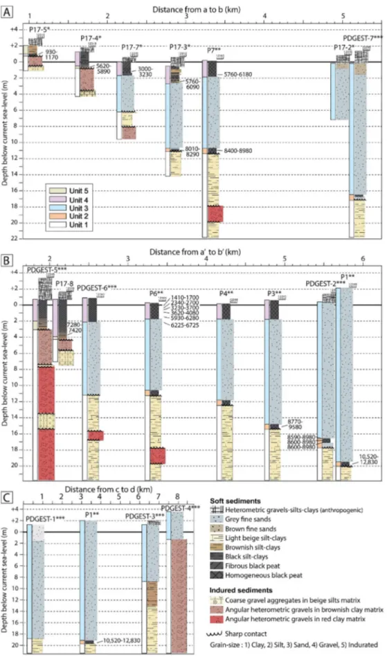
Fig. 1C shows the position of the boreholes: two transects (Fig. 3A and B) across the basin perpendicularly to the shoreline, and a parallel one (Fig. 3C) located on the beach barrier. All the boreholes except P17–2 reach the Pleistocene deposits of Unit 1 (Torres et al., 2014). The thickness of the Holocene infilling increases from the land toward the sea (1.5 m in P17-5 to 22 m in P1) and from the South-east of the basin
toward the central part (5.5 m in PDGEST-4, 10 m in PDGEST-3 and 22 m in P1 and PDGEST-1). Unit 2 (lagoon facies) occurs in 8 boreholes at four depths (Fig. 3):−20 m in P1-7, −17.5 m in PDGEST-2 and PDGEST-7,−15.5 m in P3, −11 m in P4 and P17-3, P6 and P7. Unit 2 is deeper toward the sea and shallower landward, reflecting a back-stepping retrogradational sequence associated with a transgressive system tract. Unit 2 is always capped by the shoreface sand facies (Unit 3) reflecting a marine transgression that reached its maximum of
Fig. 3. Lithostratigraphic description of the sediment cores of the Pego-Oliva wetland according to their respective position on the three transects referring to
Fig. 1C: A) southern land to sea transversal profile a-b; B) northern land to sea transversal profile a’–b’; C) longitudinal profile of the shoreline c-d. Thick black lines indicate the modern mean sea-level. Simplified chronostratigraphy based is shown beside sedimen-tary logs (colours refer to units 1 to 5). Radiocarbon ages are reported by the 2 sigma calibration interval. Asterisks indicate references to this study (*),Dupré et al., 1988; Viñals and Fumanal, 1995; Fumanal et al., 1993a, 1993b(**) andBallesteros Navarro et al., 2009(***).
landward migration 4 km to the modern shoreline. Unit 3 reaches the modern surface (0 m) at the position of the sand barrier (PDGEST-7 and PDGEST-2). In the marsh, the contact between the Unit 3 and Unit 4 occurs at−2.5 m in P17-3 and − 2 m in P17-7, P7, PDGEST-6, P6, P4, and P3. Unit 4 reflects a highstand system tract. Colluvial deposits of Unit 5 are intercalated below Unit 4 (−2 m in PDGEST-8 and P17-4) and above (P17-5).
4.2. Chronostratigraphy
Nineteen radiocarbon ages were obtained, comprising nine new ones in this study (Table 1). Compared to previous work the particular methodological attention paid to the new samples (i.e. picking up small, up to 200μm in size, identified terrestrial material one by one under a binocular loupe to avoid old carbon contamination) allows for greatly improving the chronological constrain (e.g. reducing error to a max-imum of 50 years BP). All samples except one (R-2013) are from ter-restrial macroremains (peat leave, charcoal, wood) from Unit 2 and Unit 4. The14C ages are classified following the methodology ofVacchi et al. (2016)estimating the Relative Sea Level (RSL) elevation based on environmental indicators (Table 1). Most of the14C ages (18 ages) were collected from lagoon environments influenced by marine water, which means a RSL elevation of about −0.5 m of the sample depth. One sample from a shoreface facies (Table 1) provides a minimum RSL depth position. The cumulative altimetric error associated to the RSL estimation includes the local tide (10 cm), levelling (10 cm), deforma-tion due to coring (20 cm), and angle deviadeforma-tion (10 cm for sample having depth superior to 2 m). An error of 40 cm has been applied for coring/sampling deformation for the previous studies. The RSL vertical errors are comprised between ± 0.2 and ± 0.4 m.
Results indicate that sedimentary infilling took place between 9430 and 9060 cal. BP (2σ) and Present (Fig. 4B). The pre-marine trans-gression lagoon environment (Unit 4) has provided seven 14C ages ranging from 12,830–10,520 cal. BP at −20 m, to 8290–8010 cal. BP at −11 m. The sample UBAR-77, considered with caution because of the large uncertainty (460 years BP), is discarded according to the result of the age-depth model. The modelled age at−20.5 m is 9430–9060 cal. BP (Fig. 4B) is significantly different from the age obtained at −11.5 m
(8250–8060 cal. BP). The three samples measured at −18, −18.5 and− 19 m in the same borehole (PDGEST-2) have similar ages ranging between 8675 and 9050 cal. BP (2σ). The maximum deposition
duration of this peat layer is of 375 years, indicating that the sedi-mentation rate cannot be inferior to 20 m/year. The maximal sea inland extension (4 km from the modern position) is dated at 7280–7420 cal. BP (−4 m in core P17-8). According to this result, the sea-level rise has been high up to that date with a mean value of 9 mm/year (Fig. 4B). The second lagoonal phase (Unit 4) developed on the marine sediments of Unit 3 has been dated at 6090–5760 cal. BP in core P17-3, 6180–5760 cal. BP in P7, and 6280–5930 cal. BP in P6. Overlapping ages (2σ) indicate that lagoon development was synchronic at the scale of the basin. By that time, the shoreline position was closed to the modern one, characterised by a sand barrier probably closing, at least partially, the bay of Pego-Oliva. Moreover, age continuity over the Unit 4 indicates that no significant hiatus of sedimentation or abrupt en-vironmental changes occurred from that time. Finally, several colluvial layers (Unit 5) occurred before 7420–7280 cal. BP (P17-8), before 5890–5620 cal. BP (P17-4), and after 1170–930 cal. BP (P17-5). The spatial extent of the fans has never reached Unit 3 indicating that catchment sediment supply has been modest during the Holocene.
Based on these results, the RSL position has been reconstructed for the six key-dates of the morphogenetic evolution at 9030, 8840, 8555, 8095, 7330, 5760 cal. BP (Fig. 5A). The shoreline displacement is 7 km inland in line with the wetland, and 5 km inland in the northern sector that corresponds respectively to 4 and 2 km inland compared to the present shoreline. The absolute horizontal shoreline displacement is characterised by a linear relationship and a displacement rate of 180 m/ 50 years (Supplementary material 2).
5. Discussion
5.1. Significance of the early to mid-Holocene reconstructions
At a global scale, observation and model indicate that the RSL rising rate was almost uniform from 11,650 to 7000 cal. BP (Lambeck et al., 2014). A rising rate of 8 mm/year has been documented in the Medi-terranean (Vacchi et al., 2016), that is in good agreement with the es-timated rate at Pego-Oliva of 9 mm/year (Fig. 4B). Besides, we have shown that peat layer deposition between−18.5 and −17.5 m spanned a maximum of 375 years that alsofits a rising rate of 9 mm/year. A sudden slowdown occurred at 7000 cal. BP (the best modelled age for the breakpoint is 7150 cal. BP, Supplementary Material 1) with a mean value of 0.6 mm/yr. In general, the ICE 5G-VM2 isostatic model in
Table 1
Radiocarbon ages in their sedimentation context in relation with the sea-level position. Relative Sea-Level (RSL) inferred depth, vertical error, and type of index point (Vacchi et al., 2016). Numbering refers to 1) this study; 2)Dupré et al., 1988; 3)Viñals and Fumanal, 1995; 4)Fumanal et al., 1993a, 1993b. The14C age of the
sample R-2013 is reported corrected of itsδ13C fractionation error of 1.14‰. The ages that have been excluded in the age-depth model are in italics. Core Lat. Lon. Depth
(m asl)
Material Facies Lab. code 14C years BP ΔR (yrs) Minimum
age cal. BP Maximum age cal. BP Ref RSL (m) Type of index point P17-4 38.854 0.066 0 Charcoals, peat Lagoonal Poz-93,968 4999 ± 40 5622 5891 1 −0.5 ± 0.2 index P17-5 38.855 0.073 0.8 Wood Lagoonal Poz-93,804 1100 ± 40 929 1171 1 0.3 ± 0.2 index P17-7 38.857 0.061 −1.6 Charcoals, peat Lagoonal Poz-94,010 2970 ± 35 3005 3231 1 −2.1 ± 0.2 index P17-3 38.861 0.055 −2.6 Charcoals Lagoonal Poz-93,967 5180 ± 40 5764 6095 1 −3.1 ± 0.3 index P17-8 38.876 0.088 −4 Charcoals Lagoonal Beta-460,429 6420 ± 30 7280 7421 1 −4.5 ± 0.3 index P17-3 38.861 0.055 −11 Charcoals Lagoonal Poz-93,699 7320 ± 50 8011 8292 1 −11.5 ± 0.3 index PDGEST-2 38.882 0.038 −17.5 Charcoals Lagoonal Poz-93,698 7900 ± 50 8594 8977 1 −18 ± 0.4 index PDGEST-2 38.882 0.038 −18 Peat Lagoonal Poz-93,965 7920 ± 50 8605 8978 1 −18.5 ± 0.4 index PDGEST-2 38.882 0.038 −18.5 Charcoals, peat Lagoonal Poz-93,966 7910 ± 50 8598 8977 1 −19 ± 0.4 index P-6 38.873 0.064 −0.15 Peat Lagoonal 1660 ± 50 1415 1696 2 −0.55 ± 0.3 index P-6 38.873 0.064 −0.4 Peat Lagoonal 2400 ± 60 2340 2704 2 −0.9 ± 0.3 index P-6 38.873 0.064 −0.65 Peat Lagoonal 3250 ± 100 3233 3703 2 −1.15 ± 0.3 index P-6 38.873 0.064 −0.9 Peat Lagoonal 3540 ± 80 3619 4080 2 −1.4 ± 0.3 index P-7 38.864 0.045 −1.9 Peat Lagoonal 5200 ± 60 5761 6179 2 −2.3 ± 0.3 index P-6 38.873 0.064 −1.8 Peat Lagoonal 5330 ± 90 5934 6283 2 −2.3 ± 0.3 index P-6 38.873 0.064 −2 Shell Shoreface R− 2013 6343 ± 100 94 ± 61 6224 6726 3 -2 ± 0.3 marine P-7 38.864 0.045 −10.9 Peat Lagoonal UBAR-44 7790 ± 110 8401 8977 2 −11.4 ± 0.4 index P-3 38.880 0.048 −15 Peat Lagoonal UBAR-78 8300 ± 170 8770 9580 2 −15.5 ± 0.4 index P-1 38.884 0.040 −20 Peat Lagoonal UBAR-77 10,120 ± 460 10,521 12,826 4 −20.5 ± 0.4 index
Central Spain (Vacchi et al., 2016; Fig. 4B) and the observations in Pego-Oliva are in good agreement in the Early and Mid-Holocene, while there is a misfit in the Late Holocene (Fig. 4B). This offset is likely to be explained by subsidence (Vacchi et al., 2016), that may be an effect of
tectonic and compaction (Marriner et al., 2012). Indeed, the Miocene basement of Pego-Oliva presents normal fault-limited blocks have been responsible for subsidence during the Quaternary at rates of 4 to 7 mm/ year, making conditions for deposition of a 140 m-thick sediment pile (Torres et al., 2014). Besides, during the Holocene, the newly acquired 14C ages having analytical errors greatly reduced compared to previous works (Table 1), indicates that peat layers deposited at −18 m and− 11 m have significant different ages (respectively 8594–8977 cal. BP and 8011–8292 cal. BP) indicating that during the Early Holocene, varying depths of these peat layers cannot be explained by subsidence alone.
The paleogeography reconstructions proposed inFig. 5A are built on the step backward peat sequence (Unit 2) interpreted as a lagoonal environments subjected to marine influence. Based on a literature re-view linking environmental context and RSL position, samples carried out in inner or semi-enclosed lagoon sediments are likely to correspond to a mean RSL position of 0 to−1 m (Vacchi et al., 2016). A lowering of 1 m implies a shoreline displacement of 500 m seaward (Fig. 5A), be-cause projection on the present-day bathymetry implies that bathy-metric profile has not changed from that time, an assumption that is easily arguable in context of rocky coast but that is questionable for the soft coasts like Pego-Oliva. Underwater seismic profiles and high-re-solution bathymetry carried out in the Gulf of Valencia and at the line with the Pego-Oliva basin have revealed sand wave features at depths ranging from−55 to −80 m, inferring an RSL position between −30 to −50 m (Alcántara-Carrió et al., 2013;Albarracín et al., 2013, 2014), probably associated with the Younger Dryas (12,900–11,700 cal. BP;
Blockley et al., 2012). Besides, several beachrocks are located from −25 to −35 m (Rey and Fumanal, 1996). Beachrocks, as lithified
de-posits, are generally formed in intertidal or supratidal zones, but without cement analyses, a conservative approach is to estimate a mean RSL range of +2 to−1 m (Vacchi et al., 2016). Related to these bea-chrocks, the mean RSL would have been located between −23 and −36 m. This depth interval is in agreement with the development of an
inner coastline lagoon at−20 m. Thus, considering the beachrock po-sition (Figs. 1B,4A), the shoreline could not have been more than 1 km seaward, arguing that shoreline projections on the present-day bathy-metry are relevant (Fig. 5A).
5.2. Influence of climate on the morphogenetic evolution
Three main phases of the coastal evolution have been identified at Pego-Oliva during the Early to Mid-Holocene (Fig. 5B). From 9500 to 8200 cal. BP, the retrogradational architecture is characterised by four steps of shallow inner lagoon deposits. In Iberian Mediterranean, si-milar isolated ages have been obtained for pre-marine transgression brackish lagoon deposits, dated at 10,555–9665 cal. BP in Xàbia (Viñals et al., 1993), at 8320–8180 cal. BP and 8530–8280 cal. BP in the Al-bufera (Carmona and Ruiz, 2011; Carmona et al., 2016). A similar timing of the backstepping sequence has been found in the Rhone delta at 9800–8200 cal. BP (Amorosi et al., 2013a), in Tuscany at 9600–7880 cal. BP (Amorosi et al., 2013b), in the Adriatic Sea at 9200–7700 cal. BP (Amorosi et al., 2017). Retrogradational coastal sequences are in accordance with the high global RSL rising rate of the end of the last glaciation relative to the Laurentide ice sheet dis-mantling (Roy and Peltier, 2018). From 8200 to 7300 cal. BP, the backward shoreline migration reached a maximal inland position leading to the disappearance of the former inner lagoon. The marine transgression inland has been dated in Xàbia, in the Pego vicinity at 7570–6865 cal. BP (Viñals and Fumanal, 1995). In the Valencian gulf, the maximal inland position of the beach dated at 7500–7200 cal. BP (Carmona and Ruiz, 2011) has also been associated with the desiccation of several coastal lagoons (Marco-Barba et al., 2013;Blázquez et al., 2017). In very detailed sequences, this evolution has been constrained at 7700–7000 cal. BP in Po delta (Amorosi et al., 2017) and at 7840–7000 cal. BP in Tuscan (Amorosi et al., 2013b). This period cor-responds to the complete melting of former ice-sheets that occurred around 8000–7500 cal. BP (Roy and Peltier, 2018). Following the maximum of inlandflooding, barrier construction led to the formation of an inner coastal lagoon since 5800 cal. BP in Pego-Oliva. In the Mediterranean, the RSL global stabilisation has resulted in the forma-tion of highstand system tracts related to seaward progradaforma-tion of river
Fig. 4. A) Interpretative sketch of the sediment infilling reported according to the land to sea transect A-B (Fig. 1C) based on 14 boreholes, seismic profile, current
topography, and bathymetry. B) Age-depth model calculated from the probabilities density functions of the14C ages of Pego-Oliva compared to the predicted
deltas (Anthony et al., 2014;Amorosi et al., 2013a), coastal barrier system constructions and large development of lagoon environments (Marco-Barba et al., 2013; Blázquez et al., 2017; Melis et al., 2017;
Melis et al., 2018;Pascucci et al., 2018).
In the Mediterranean, a large range of literature proposes a causal link between coastal evolution and the sub-millennial North Atlantic Oscillation for the last 7000 years (Zazo et al., 2008;Amorosi et al., 2017; Pascucci et al., 2018), because highstand systems tract has al-lowed for the recording of small-amplitude regressive and transgressive cycles (Fruergaard et al., 2015). Fewer data exist during the Early to Mid-Holocene (Amorosi et al., 2013a;Amorosi et al., 2017). A cause of RSL variability can be linked to thermal expansion of water masses related to sea temperature (González and Törnqvist, 2009). However, as western Mediterranean Sea surface temperatures are relatively stable over the Early Holocene (Jalali et al., 2016), it seems unlikely that thermal expansion/contraction explains the evolution at Pego-Oliva. Another explanation could be related to the alternation of pulse and pause of the RSL. Five transgressive phases have been recorded at Pego-Oliva (Fig. 5B) at 9500 (n°1), 9100–9000 (n°2), 8750–8650 (n°3),
8450–8200 (n°4), and 8100–7300 cal. BP (n°5). The phases 4 and 5 may match with meltwater pulses identified in the North Atlantic (Nesje et al., 2004; Smith et al., 2011) (Fig. 5B). A linkage between North Atlantic has been suggested in the North-East Mediterranean where drops in water salinity were caused by enhancing outflow from the Black-Sea during its high level phases (Herrle et al., 2018). Corre-spondence between morphogenetic evolution and meltwater pulses suggests a potential linkage although it remains unclear whether they could have been significant enough to be recorded compared to the massive ice sheets dismantling of the Early Holocene. Finally, sand spit progradation and lagoon formation may be influenced by climate variability by increasing sediment supply entering into the system from rivers and its redistribution along the coast through intensification of longshore drift velocity. Iberian Mediterranean river activity presents an opposite pattern to Pego-Oliva lagoon formation that does not argue for an increase of the sediment supply (Thorndycraft and Benito, 2006). Besides, a prolonged period of deep-sea current intensification offshore of the Balearic island is recorded between 9500 and 8000 cal. BP (Frigola et al., 2007), concomitant to higher ice-rafted debris in the Northern Atlantic (Bond et al., 2001). Together, it argues that cold and dry climate events may have locally increased wind intensity, and thus longshore drift velocity. For example, the 8200 cal. BP climate event has been depicted as an aridity crisis in the regional continental ar-chives (Morellón et al., 2008;Jones et al., 2018).
5.3. Socio-ecological adaptation during the early to mid-Holocene The area of Pego-Oliva has been occupied by prehistoric commu-nities during the Early and Mid-Holocene (Fumanal et al., 1993b). In order to investigate the influence of coastal evolution on human oc-cupation patterns, we have compared the results of this study with the chronological and occupational evidences of the Mesolithic site of El Collado and the Neolithic site of El Barranquet, both located 5 km north of Pego-Oliva (Fig. 5A and B). The presence of inner coastal lagoons, dated from 9500 to 8200 cal. BP was concomitant to the occupation of El Collado site during both the Early and the Late Mesolithic
(Fernández-López de Pablo, 2016). Shallow brackish lagoonal waters in the site vicinity have certainly offered a diversity of resources, in-cluding marine mollusc andfish, as it has been reported along the Early Mesolithic levels of El Collado sequence (Fernández-López de Pablo and Gabriel, 2016). Indeed, among marine molluscs the assemblages were noticeably dominated by Cerastoderma glaucum, a marine bivalve in-habiting soft sandy to muddy substrates of brackish lagoon waters and low-energy environment (Ivell, 1979). Marine resources collected in this coastal environment were relevant for the Early Mesolithic com-munities occupying this area, as independently suggested by the pa-leodietary isotope analyses on human remains, indicative of an intake of proteins of marine origin of 25% (García Guixé et al., 2006).
It is worth noting that malacological assemblages have shown dia-chronic differences in the intensity of shellfish exploitation. The two Early Mesolithic phases display a more intense exploitation of shellfish andfish compared to the Late Mesolithic layer in which a significant decrease of the frequency and size of C. glaucum valves are documented at about 8500 cal. BP (Fernández-López de Pablo and Gabriel, 2016). Our results suggest that the reduction of the shellfish productivity was driven by a contraction of the coastal lagoons associated with the sea-level rise. Interestingly, the presence of a short Late Mesolithic occu-pational interval postdating the chronological span of the funerary activity suggests a change in the settlement pattern probably toward more ephemeral occupations. At this moment, our results date the disappearance of the lagoon biotope right after 8200 cal. BP at Pego-Oliva, one of the shellfish collecting areas exploited over generations during the Mesolithic. Moreover, the absence of pre-transgressive la-goonal deposits in a 20 km radius (Fumanal et al., 1993b) reinforces the interpretation of a major reduction of these habitats in the settlement's vicinity. In addition of loss of biota caused by marine flooding, the backward migration of the shoreline is likely to have also reduced the spatial extension of the colluvial glacis favourable for hunting terres-trial game. Altogether, it is likely that these changes have dramatically reduced the carrying capacity of the ecosystem rendering this area less attractive to forager communities.
The environmental mutation consecutive to the global sea-level rise negatively impacted the Late Mesolithic subsistence and settlement patterns, probably driving to a significantly lower occupational in-tensity (even depopulation) of this coastal area. Indeed, the end of the occupation at El Collado site coincides with a spatial re-organization of the Late Mesolithic settlement networks and the lack of archaeological sites dated in the adjacent valleys (Gómez-Puche and Fernández-López de Pablo, 2015). The subsequent Final Mesolithic occupations, that have been dated between 7900 and 7700 cal. BP, occurred as inland patches about 60 km away from the coast (Fernández-López de Pablo et al., 2013;García-Puchol et al., 2018). After 700 years (Fig. 5B) from the last dated Mesolithic occupations, the area of Pego-Oliva witnessed the arrival of the first farming communities as represented by the Earliest Neolithic phase of El Barranquet site. This dynamic supports the model of pioneer maritime colonization in Eastern Iberia (Zilhão, 2001; Isern et al., 2017) implying a leap-frog dispersal modality by which the earliest farmers established their settlements in unoccupied areas by Final Mesolithic (Bernabeu and Martí, 2014;Bernabeu Aubán et al., 2017). Preliminary data on the mollusc assemblages of El Bar-ranquet (Luján Navas, 2016) suggests that a major change in the
Fig. 5. A) Projected sea-level position at selected key-dates (best age cal. BP) of the morphogenetic evolution on the current elevation contours, that includes the vertical error estimate. The two archaeological sites are shown by stars. The thick black arrows point out the kinematic of shoreline evolution through time. B) Comparison of the coastal morphogenetic evolution at Pego-Oliva with key-dates of the morphogenetic evolution and a simplified representation of transgressive and stillstand phases (this study1), with phases of freshwater meltwater pulses (MWP) fromSmith et al. (2011)3andLiu et al. (2004)4, and with the Ice-Rafted Debris
(IRD), a proxy of the North Atlantic oscillation (Bond et al., 2001)5. The absolute horizontal displacement of the shoreline at Pego-Oliva referring to the oldest
key-date (yellow line in A) is represented according to the best age-distance model (black line) and its 95% confidence (grey envelope). Morphogenetic evolution of the coast is compared to the chronology of the Mesolithic and Neolithic settlements located in the study area (6Fernández-López de Pablo, 2016– Bayesian
chronos-tratigraphic model of the14C ages;7Bernabeu et al., 2009– individual calibrated14C ages from the Precardial pottery phase,8Esquembre-Bebia et al., 2008–
estimated age of the Postcardial pottery phase). Contour colours in A of the selected key-dates refer to colours of the age probability distributions in B. (For interpretation of the references to colour in thisfigure legend, the reader is referred to the web version of this article.)
relative abundance of marine bivalves collected for consumption oc-curred between the two Early Neolithic phases. C. glaucum species dominate the Impressa phase whereas the Postcardial layers show a higher representation of Glycimeris glycymeris. This shift in favour of infralittoral species in the archaeological record is in agreement with the environmental reconstruction that shows that the beachfront was getting closer to the site, reaching its proximal position at 7300 cal. BP (Fig. 5A), right after the Precardial phase and during the Postcardial (Fig. 5B). Altogether, these results suggest a lose link between nearby ecosystems and subsistence choices, arguing that the Neolithic com-munities have adapted species collection to the resource locally avail-able.
Based on the Early to Mid-Holocene geomorphological reconstruc-tions at Pego-Oliva, a vertical sea-level rising rate of 50 cm/50 years has been estimated (Fig. 4B); that once translated into paleogeographical reconstructions (Fig. 5A) allows to estimate a horizontal displacement rate of the shoreline of 180 m/50 years (Fig. 5B). Both vertical and horizontal shoreline displacement rates are rapid enough to be per-ceptible by human communities, at a level of 1 to 2 generations only, as it has been also suggested during the Early Holocene inundation of North-Western Europe (Sturt et al., 2013). More than the vertical rate, the rapidity with which the shoreline came closer may have also in-creased vulnerability to short high-energy marine events (Leary, 2009). Taking into account that Mesolithic occupation of El Collado has spanned 1022–1965 years (Fernández-López de Pablo, 2016); this context of highly changing landscapes must have been perceptible by the last hunter-gatherers.Conneller et al. (2016)have rather suggested that landscapes “produced and continually reproduced by sea-level rise” may have in fact encouraged exploitation. Nevertheless, the adaptiveflexibility of these populations seems to have faced very im-portant environmental changes at 8200 cal. BP, with the extinction of previously exploited ecosystems, and abandonment of the El Collado implantation. The hypothesis of a convergence of environmental events rendering populations more sensitive could be made (Leary, 2009). Based on this case-study, it may have resulted in the superimposition of the repercussion of the long-term sea-level rise on the coastal geo-morphology and ecosystems, with the abrupt aridity event that has occurred at 8200 cal. BP. Finally, our results show that once the last foragers left, a new population with a different cultural baggage (first Neolithic) settled in the same environment. It clearly comes out that the perception of this same environment has been different for populations with different cultural backgrounds. Thus, this case-study of past Human-environment interactions runs counter to subjective valuations of ecosystems in terms of services or constraints for society (e.g.
Costanza et al., 2014). We plead for a more thorough consideration of the local and regional scales of socio-ecological interactions and re-organisations when investigating resilience and adaptive strategies of societies to global changes past and present (Redman, 2005;Van de Noort, 2011).
6. Conclusions
This paper investigated how coastal evolution affected settlement and subsistence patterns during the Mesolithic-Neolithic transition. Based on multiple sediment coring in the Pego-Oliva basin, new sedi-mentological analyses and14C dates combined with previous biological works, we have reconstructed the geometry of the sedimentary facies and the timing of depositions throughout the Holocene. Three main periods have been identified; from 9500 to 8200 cal. BP, the stepwise inland migration of the coastline consecutive to sea-level rise has led to the deposition of four individual peat layers at 20.5, 18.5, 15.5 and 11.5 m below the present sea-level. We interpret this stepwise trans-gression as a result of periods of acceleration of barrier construction associated with higher drift velocity linked with a drier climate (e.g. at 8200 cal. BP). The transgressive phases, that have been dated at 9500, 9100–9000, 8750–8650, 8450–8200, and 8100–7300 cal. BP, match
with some of the phases of meltwater pulses in the North Atlantic. From 8200 to 7200 cal. BP, the pursuit of the backward migration of the coastline provokes the disappearance of the coastal lagoons. The max-imum of the marine transgression, 2 km inland, is dated at 7200 cal. BP. This timing is very similar to other Mediterranean records. From 7200 cal. BP to Present: following sea-level stabilisation, sand barrier reconstruction promoted the basin closing, inducing a return to a coastal barrier-lagoon system at 5800 cal. BP, when the shoreline po-sition was similar to the modern's one.
Results have been compared to the archaeological records of the same area. The interdisciplinary approach allowed us to interpret that: 1) the long-lasting occupation of the Mesolithic shell midden of El Collado has corresponded to the period of presence of coastal lagoon, offering a diversity of marine resource available, easily exploited in the inter-tidal shallow and brackish waters; 2) the spatial contraction of the coastal lagoon has corresponded to the sharp drop in Cerastoderma glaucum species during the Late Mesolithic, suggesting that the marine resource depletion primarily occurred because of a decrease in marine resource productivity; 3) the abandonment of the El Collado site and the 700 years' temporal hiatus observed between the Mesolithic and Neolithic implantations is likely to be explained by the consequence of the disappearance of the coastal lagoon and the formerly exploited biotopes at 8200 cal. BP, that may have been together with the aridity crisis occurring at that time factors of depopulation of this area; 4) the maximal inland transgression of the sea at 7200 cal. BP has been con-temporary of a shift toward more infralittoral marine shell assemblages during the Postcardial phase at El Barranquet site suggesting that Early Neolithic populations have successfully adapted to rapidly changing environments.
We concluded that prehistoric communities with different cultural baggage have had different perceptions of their environment, ques-tioning subjective valuations of ecosystems in terms of services or costs for society, and emphasising the importance of examining socio-eco-logical reorganisations at the local and regional scale when in-vestigating adaptive strategy to global changes.
Funding
This work is a contribution to the project MedCoRes (ref. 704822) “Mediterranean Coastal Resources: benefits and constraints for Prehistoric hunters-gatherers” funded by the Marie Sklodowska-Curie Action (European Union) led by E. Brisset (IPHES, URV) and has benefited of the support of the AGAUR agency (SGR 836 Research Group) and the MINECO project Postglacial-Med (HAR2017-88503-P). J. Fernández-López de Pablo (IPHES, URV) is supported by the MINECO Grant IEDI-2017-00889.
Acknowledgments
We are grateful to Helena Velayos Mayo and Javier Muñoz of the Litoteca of the Instituto Geológico y Minero de España (IGME) to have kindly facilitated consultation and sampling of the archives. We also thank Malebogo Mvimi (MNHN, IPHES) for her help in the English editing, and two anonymous reviewers for their insightful comments. Appendix A. Supplementary data
Supplementary data to this article can be found online athttps:// doi.org/10.1016/j.gloplacha.2018.07.016.
References
Albarracín, S., Alcántara-Carrió, J., Barranco, A., García, M.J.S., Bouzas, Á.F., Salgado, J.R., 2013. Seismic evidence for the preservation of several stacked Pleistocene coastal barrier/lagoon systems on the Gulf of Valencia continental shelf (western Mediterranean). Geo-Mar. Lett. 33, 217–223.
https://doi.org/10.1007/s00367-012-0315-x.
Albarracín, S., Alcántara-Carrió, J., Montoya-Montes, I., Fontán-Bouzas, Á., Somoza, L., Amos, C.L., Salgado, J.R., 2014. Relict sand waves in the continental shelf of the Gulf of Valencia (Western Mediterranean). J. Sea Res. 93, 33–46.https://doi.org/10. 1016/j.seares.2013.12.014.
Alcántara-Carrió, J., Albarracín, S., Montes, I.M., Flor-Blanco, G., Bouzas, Á.F., Salgado, J.R., 2013. An indurated Pleistocene coastal barrier on the inner shelf of the Gulf of Valencia (western Mediterranean): evidence for a prolonged relative sea-level still-stand. Geo-Mar. Lett. 33, 209–216.https://doi.org/10.1007/s00367-012-0316-9. Amorosi, A., Rossi, V., Vella, C., 2013a. Stepwise post-glacial transgression in the Rhône
Delta area as revealed by high-resolution core data. Palaeogeogr. Palaeoclimatol. Palaeoecol. 374, 314–326.https://doi.org/10.1016/j.palaeo.2013.02.005. Amorosi, A., Rossi, V., Sarti, G., Mattei, R., 2013b. Coalescent valleyfills from the late
Quaternary record of Tuscany (Italy). Quat. Int. 288, 129–138.https://doi.org/10. 1016/j.quaint.2011.10.015.
Amorosi, A., Bruno, L., Campo, B., Morelli, A., Rossi, V., Scarponi, D., Hong, W., Bohacs, K.M., Drexler, T.M., 2017. Global sea-level control on local parasequence architecture from the Holocene record of the Po Plain, Italy. Mar. Petrol. Geol. Sedimentol. Italy 87, 99–111.https://doi.org/10.1016/j.marpetgeo.2017.01.020.
Anthony, E.J., Marriner, N., Morhange, C., 2014. Human influence and the changing geomorphology of Mediterranean deltas and coasts over the last 6000years: from progradation to destruction phase? Earth Sci. Rev. 139, 336–361.https://doi.org/10. 1016/j.earscirev.2014.10.003.
Aparicio, P., 2014. El Collado, in: Pleistocene and Holocene Hunter Gatherers in Iberia and the Gibraltar Strait: The Current Archaeological Record. University of Burgos, Sala Ramos R, pp. 338–344.
Bailey, G., 2004. World prehistory from the margins: the role of coastlines in human evolution. J. Interdisc. Stud. Hist. Archaeol. 39–50.
Ballesteros Navarro, B., Domínguez Sánchez, J.A., Díaz-Losada, E., Garı́ca Menéndez, O., 2009. Zonas húmedas mediterráneas y acuíferos asociados. Condicionantes hidrogeológicos del Marjal de Pego-Oliva (Alicante-Valencia). Bol. Geol. Min. 120, 459–478.
Benjamin, J., Rovere, A., Fontana, A., Furlani, S., Vacchi, M., Inglis, R.H., Galili, E., Antonioli, F., Sivan, D., Miko, S., Mourtzas, N., Felja, I., Meredith-Williams, M., Goodman-Tchernov, B., Kolaiti, E., Anzidei, M., Gehrels, R., 2017. Late Quaternary sea-level changes and early human societies in the central and eastern Mediterranean Basin: an interdisciplinary review. Quat. Int. 449, 29–57.https://doi.org/10.1016/j. quaint.2017.06.025.
Bernabeu Aubán, J., García Puchol, O., Orozco-Köhler, T., 2017. New insights relating to the beginning of the Neolithic in the eastern Spain: Evaluating empirical data and modelled predictions. Quat. Int.https://doi.org/10.1016/j.quaint.2017.03.071.
Bernabeu, J., Martí, B., 2014. Thefirst agricultural groups in the Iberian peninsula. In: Manen, C., Perrin, T., Guilaine, J. (Eds.), The Neolithic Transition in the Mediterranean, pp. 419–438.
Bernabeu, J., Molina, L.L., Esquembre-Bebia, M.A., Ortega, J.R., Boronat, J., 2009. In: D'ailleurs, De Méditerranée et, Jean Guilaine, Mélanges Offerts a (Eds.), La cerámica impresa mediterránea en el origen del Neolítico de la península ibérica. Collectif, Toulouse, pp. 83–95.
Blaauw, M., 2010. Methods and code for“classical” age-modelling of radiocarbon se-quences. Quat. Geochronol. 5, 512–518.https://doi.org/10.1016/j.quageo.2010.01. 002.
Blázquez, A.M., Rodríguez-Pérez, A., Torres, T., Ortiz, J.E., 2017. Evidence for Holocene sea level and climate change from Almenara marsh (western Mediterranean). Quat. Res. 88, 206–222.https://doi.org/10.1017/qua.2017.47.
Blockley, S.P.E., Lane, C.S., Hardiman, M., Rasmussen, S.O., Seierstad, I.K., Steffensen, J.P., Svensson, A., Lotter, A.F., Turney, C.S.M., Bronk Ramsey, C., 2012. Synchronisation of palaeoenvironmental records over the last 60,000 years, and an extended INTIMATE event stratigraphy to 48,000 b2k. Quat. Sci. Rev. 36, 2–10.
https://doi.org/10.1016/j.quascirev.2011.09.017.
Bond, G., Kromer, B., Beer, J., Muscheler, R., Evans, M.N., Showers, W., Hoffmann, S., Lotti-Bond, R., Hajdas, I., Bonani, G., 2001. Persistent solar influence on North Atlantic climate during the holocene. Science 294, 2130–2136.https://doi.org/10. 1126/science.1065680.
Burnett, M.R., August, P.V., Brown, J.H., Killingbeck, K.T., 1998. The influence of geo-morphological heterogeneity on biodiversity I. A patch-scale perspective. Conserv. Biol. 12, 363–370.https://doi.org/10.1111/j.1523-1739.1998.96238.x.
Carmona, P., Ruiz, J.M., 2011. Historical morphogenesis of the Turia River coastalflood plain in the Mediterranean littoral of Spain. Catena 86, 139–149.https://doi.org/10. 1016/j.catena.2010.12.006.
Carmona, P., Ruiz-Pérez, J.-M., Blázquez, A.-M., López-Belzunce, M., Riera, S., Orengo, H., 2016. Environmental evolution and mid–late Holocene climate events in the Valencia lagoon (Mediterranean coast of Spain). The Holocene 26, 1750–1765.
https://doi.org/10.1177/0959683616645940.
Colonese, A.C., Mannino, M.A., Bar-Yosef Mayer, D.E., Fa, D.A., Finlayson, J.C., Lubell, D., Stiner, M.C., 2011. Marine mollusc exploitation in Mediterranean prehistory: an overview. Quat. Int. Shell Midden Res. 239, 86–103.https://doi.org/10.1016/j. quaint.2010.09.001.
Colonese, A.C., Lo Vetro, D., Landini, W., Di Giuseppe, Z., Hausmann, N., Demarchi, B., D'Angelo, C., Leng, M.J., Incarbona, A., Whitwood, A.C., Martini, F., 2018. Late Pleistocene-Holocene coastal adaptation in central Mediterranean: snapshots from Grotta d'Oriente (NW Sicily). Quat. Int.https://doi.org/10.1016/j.quaint.2018.06. 018.
Conneller, C., Bates, M., Bates, R., Schadla-Hall, T., Blinkhorn, E., Cole, J., Pope, M., Scott, B., Shaw, A., Underhill, D., 2016. Rethinking human responses to sea-level rise: the Mesolithic occupation of the channel islands. Proc. Prehist. Soc. 82, 27–71.
https://doi.org/10.1017/ppr.2016.1.
Costa, L.-J., V., J.-D., Bocherens, H., Desse-Berset, N., Heinz, C., (de) L., F., Magdeleine, J., R., M.P., Thiébault, S., Tozzi, C., 2003. Early settlement on Tyrrhenian islands (8th millennium cal. BC): Mesolithic adaptation to local resources in Corsica and Northern Sardinia. UISPP, Stockholm, Denmark, pp. 3–10.
Costanza, R., de Groot, R., Sutton, P., van der Ploeg, S., Anderson, S.J., Kubiszewski, I., Farber, S., Turner, R.K., 2014. Changes in the global value of ecosystem services. Glob. Environ. Chang. 26, 152–158.https://doi.org/10.1016/j.gloenvcha.2014.04. 002.
Currás, A., Ghilardi, M., Peche-Quilichini, K., Fagel, N., Vacchi, M., Delanghe, D., Dussouillez, P., Vella, C., Bontempi, J.M., Ottaviani, J.-C., 2017. Reconstructing past landscapes of the eastern plain of Corsica (NW Mediterranean) during the last 6000 years based on molluscan, sedimentological and palynological analyses. J. Archaeol. Sci. Rep. 12, 755–769.https://doi.org/10.1016/j.jasrep.2016.09.016. Dolez, L., Salel, T., Bruneton, H., Colpo, G., Devillers, B., Lefèvre, D., Muller, S.D.,
Sanchez, C., 2015. Holocene palaeoenvironments of the Bages-Sigean lagoon (France). Geobios 48, 297–308.https://doi.org/10.1016/j.geobios.2015.05.002. Dupont, C., Tresset, A., Desse-Berset, N., Gruet, Y., Marchand, G., Schulting, R., 2009.
Harvesting the seashores in the late mesolithic of northwestern Europe: a view from Brittany. J. World Prehist. 22, 93–111.https://doi.org/10.1007/s10963-009-9017-3. Dupré, M., Fumanal, M.P., Sanjaume, E., Santisteban, C., Usera, J., Viñals, M.J., 1988.
Quaternary evolution of the Pego coastal lagoon (Southern Valencia, Spain). Palaeogeogr. Palaeoclimatol. Palaeoecol. Quat. Coastal Changes 68, 291–299.
https://doi.org/10.1016/0031-0182(88)90046-6.
Erlandson, J.M., 2001. The archaeology of aquatic adaptations: paradigms for a new millennium. J. Archaeol. Res. 9, 287–350.https://doi.org/10.1023/
A:1013062712695.
Esquembre-Bebia, M.A., de Soler, J.D.B., Maestre, F.J.J., Hernández, F.J.M., Navas, A.L., de Pablo, J.F.L., Valle, R.M., Eres, M.P.I., García, C.F., Pastor, R.R., Pérez, J.R.O., 2008. El yacimiento neolítico del Barranquet de Oliva (Valencia). Presented at the IV Congreso del Neolítico Peninsular, Museo Arqueológico de Alicante. pp. 183–190. Fernández-López de Pablo, J., 2016. The timing of postglacial coastal adaptations in
Eastern Iberia: a Bayesian chronological model for the El Collado shell midden (Oliva, Valencia, Spain). Quat. Int. 407, 94–105.https://doi.org/10.1016/j.quaint.2015.10. 077.
Fernández-López de Pablo, J., Gabriel, S., 2016. El Collado shell midden and the ex-ploitation patterns of littoral resources during the Mesolithic in the Eastern Iberian Peninsula. Quat. Int. 407, 106–117.https://doi.org/10.1016/j.quaint.2015.11.100. Fernández-López de Pablo, J., Salazar-García, D.C., Subirà-Galdacano, M.E., Roca De
Togores, C., Gómez-Puche, M., Richards, M.P., Esquembre-Bebiá, M.A., 2013. Late Mesolithic burials at casa corona (Villena, Spain): direct radiocarbon and palaeo-dietary evidence of the last forager populations in Eastern Iberia. J. Archaeol. Sci. 40, 671–680.https://doi.org/10.1016/j.jas.2012.09.005.
Fontana, A., Vinci, G., Tasca, G., Mozzi, P., Vacchi, M., Bivi, G., Salvador, S., Rossato, S., Antonioli, F., Asioli, A., Bresolin, M., Di Mario, F., Hajdas, I., 2017. Lagoonal set-tlements and relative sea level during bronze age in northern Adriatic:
Geoarchaeological evidence and paleogeographic constraints. Quat. Int. 439, 17–36.
https://doi.org/10.1016/j.quaint.2016.12.038.
Frigola, J., Moreno, A., Cacho, I., Canals, M., Sierro, F.J., Flores, J.A., Grimalt, J.O., Hodell, D.A., Curtis, J.H., 2007. Holocene climate variability in the western Mediterranean region from a deepwater sediment record. Paleoceanography 22.
https://doi.org/10.1029/2006PA001307.
Fruergaard, M., Møller, I., Johannessen, P.N., Nielsen, L.H., Andersen, T.J., Nielsen, L., Sander, L., Pejrup, M., 2015. Stratigraphy, evolution, and controls of a Holocene transgressive–regressive Barrier Island under changing sea level: Danish North Sea coast controls on barrier-island evolution. J. Sediment. Res. 85, 820–844.https://doi. org/10.2110/jsr.2015.53.
Fumanal, M.P., Mateu, G., Rey, J., Somoza, L., Viñals, M.J., 1993a. Las unidades mor-fosedimentarias cuaternarias del litoral del Cap de la Nau (Valencia-Alicante) y su correlación con la plataforma continental. Estudios sobre Cuaternario 53–64.
Fumanal, M.P., Viñals, M.J., Ferrer, C., Aura, E., Bernabeu, J., Casabó, J., Gisbert, J., Sentí, M.A., 1993b. Litoral y poblamiento en el litoral valenciano durante el Cuaternario reciente: Cap de Cullera-Puntal de Moraira. Estudios sobre Cuaternario 249–259.
García Guixé, E., Richards, M.P., Subirà, M.E., 2006. Palaeodiets of humans and fauna at the Spanish mesolithic site of El Collado. Curr. Anthropol. 47, 549–557.https://doi. org/10.1086/504170.
García-Puchol, O., McClure, S.B., Juan-Cabanilles, J., Diez-Castillo, A.A., Bernabeu-Aubán, J., Martí-Oliver, B., ... 2018. Cocina cave revisited: Bayesian radiocarbon chronology for the last hunter-gatherers andfirst farmers in Eastern Iberia. Quaternary International 472, 259–271.
Gibaja, J.F., Subirà, M.E., Terradas, X., Santos, F.J., Agulló, L., Gómez-Martínez, I., Allièse, F., de Pablo, J.F.-L., 2015. The emergence of mesolithic cemeteries in SW Europe: insights from the El Collado (Oliva, Valencia, Spain) radiocarbon record. PLoS One 10, e0115505.https://doi.org/10.1371/journal.pone.0115505.
Gómez-Puche, M., Fernández-López de Pablo, J., 2015. AMS radiocarbon Chronology of Late Mesolithic Sites in the Upper Vinalopo Valley (Eastern Iberia). In: Bicho, Nuno, Detry, Cleia, Douglas Price, T., Cunha, Eugénia (Eds.), The 150th Anniversary of the Discovery of Mesolithic Shell Middens, pp. 109–124.
González, J.L., Törnqvist, T.E., 2009. A new Late Holocene sea-level record from the Mississippi Delta: evidence for a climate/sea level connection? Quat. Sci. Rev. Quat. Ice Sheet Ocean Interactions Landsc. Res. 28, 1737–1749.https://doi.org/10.1016/j. quascirev.2009.04.003.
Goude, G., Willmes, M., Wood, R., Courtaud, P., Leandri, F., Cesari, J., Grün, R., 2017. New insights into mesolithic human diet in the mediterranean from stable isotope analysis: the sites of Campu Stefanu and Torre d'Aquila, Corsica. Int. J. Osteoarchaeol. 27, 707–714.https://doi.org/10.1002/oa.2578.
Herrle, J.O., Bollmann, J., Gebühr, C., Schulz, H., Sheward, R.M., Giesenberg, A., 2018. Black Sea outflow response to Holocene meltwater events. Sci. Rep. 8, 4081.https:// doi.org/10.1038/s41598-018-22453-z.
Isern, N., Zilhão, J., Fort, J., Ammerman, A.J., 2017. Modeling the role of voyaging in the coastal spread of the Early Neolithic in the West Mediterranean. PNAS 114, 897–902.
https://doi.org/10.1073/pnas.1613413114.
Ivell, R., 1979. The biology and ecology of a brackish lagoon bivalve, C. glaucum, in Lago Lungo, Italy. J. Molluscan Stud. 45, 364–382.
Jakobsson, M., Pearce, C., Cronin, T.M., Backman, J., Anderson, L.G., Barrientos, N., Björk, G., Coxall, H., de Boer, A., Mayer, L.A., Mörth, C.-M., Nilsson, J., Rattray, J.E., Stranne, C., Semiletov, I., O'Regan, M., 2017. Post-glacialflooding of the Bering Land Bridge dated to 11 cal ka BP based on new geophysical and sediment records. Clim. Past 13, 991–1005.https://doi.org/10.5194/cp-13-991-2017.
Jalali, B., Sicre, M.-A., Bassetti, M.-A., Kallel, N., 2016. Holocene climate variability in the North-Western Mediterranean Sea (Gulf of Lions). Clim. Past 12, 91–101.https://doi. org/10.5194/cp-12-91-2016.
Jones, S.E., Burjachs, F., Ferrer-García, C., Giralt, S., Schulte, L., Fernández-López De Pablo, J., 2018. A multi-proxy approach to understanding complex responses of salt-lake catchments to climate variability and human pressure: a Late Quaternary case study from south-eastern, Spain. Quat. Sci. Rev. 184, 201–223.https://doi.org/10. 1016/j.quascirev.2017.12.015.
Lambeck, K., Rouby, H., Purcell, A., Sun, Y., Sambridge, M., 2014. Sea level and global ice volumes from the Last Glacial Maximum to the Holocene. PNAS 111, 15296–15303.
https://doi.org/10.1073/pnas.1411762111.
Leary, J., 2009. Perceptions of and responses to the Holoceneflooding of the north sea lowlands. Oxf. J. Archaeol. 28, 227–237.https://doi.org/10.1111/j.1468-0092. 2009.00326.x.
Liu, J.P., Milliman, J.D., Gao, S., Cheng, P., 2004. Holocene development of the Yellow River's subaqueous delta, North Yellow Sea. Mar. Geol. 209, 45–67.https://doi.org/ 10.1016/j.margeo.2004.06.009.
Luján Navas, A., 2016. Aprovechamiento y gestión de recursos malacológicos marinos en la fachada Mediterránea de la Peninsula Ibérica durante la Prehistoria reciente. Universidad de Alicante, Spain.
Mannino, M.A., Thomas, K.D., Leng, M.J., Di Salvo, R., Richards, M.P., 2011. Stuck to the shore? Investigating prehistoric hunter-gatherer subsistence, mobility and territori-ality in a Mediterranean coastal landscape through isotope analyses on marine mollusc shell carbonates and human bone collagen. Quat. Int. 244, 88–104.https:// doi.org/10.1016/j.quaint.2011.05.044.
Marco-Barba, J., Holmes, J.A., Mesquita-Joanes, F., Miracle, M.R., 2013. The influence of climate and sea-level change on the Holocene evolution of a Mediterranean coastal lagoon: evidence from ostracod palaeoecology and geochemistry. Geobios 46, 409–421.https://doi.org/10.1016/j.geobios.2013.05.003.
Marriner, N., Flaux, C., Morhange, C., Kaniewski, D., 2012. Nile Delta's sinking past: quantifiable links with Holocene compaction and climate-driven changes in sediment supply? Geology 40, 1083–1086.https://doi.org/10.1130/G33209.1.
Melis, R.T., Depalmas, A., Di Rita, F., Montis, F., Vacchi, M., 2017. Mid to late Holocene environmental changes along the coast of western Sardinia (Mediterranean Sea). Glob. Planet. Chang. 155, 29–41.https://doi.org/10.1016/j.gloplacha.2017.06.001. Melis, R.T., Di Rita, F., French, C., Marriner, N., Montis, F., Serreli, G., Sulas, F., Vacchi, M., 2018. 8000 years of coastal changes on a western Mediterranean island: a mul-tiproxy approach from the Posada plain of Sardinia. Mar. Geol. 403, 93–108.https:// doi.org/10.1016/j.margeo.2018.05.004.
Meyers, P.A., Teranes, J.L., 2001. Sediment organic matter. In: Last, W.M., Smol, J.P. (Eds.), Tracking Environmental Change Using Lake Sediments, Developments in Paleoenvironmental Research. Springer, Netherlands, pp. 239–269.
Morellón, M., Valero-Garcés, B., Moreno, A., González-Sampériz, P., Mata, P., Romero, O., Maestro, M., Navas, A., 2008. Holocene palaeohydrology and climate variability in northeastern Spain: the sedimentary record of Lake Estanya (Pre-Pyrenean range). In: Quaternary International, The Last 15ka of Environmental Change in Mediterranean Regions - Interpreting Different Archives. 181. pp. 15–31.https://doi.org/10.1016/j. quaint.2007.02.021.
Nesje, A., Dahl, S.O., Bakke, J., 2004. Were abrupt Lateglacial and early-Holocene cli-matic changes in northwest Europe linked to freshwater outbursts to the North Atlantic and Arctic Oceans? The Holocene 14, 299–310.https://doi.org/10.1191/ 0959683604hl708fa.
Pascucci, V., De, F., Del, V., Sanna, I., Melis, R.T., Andreucci, S., 2018. Climate changes and human impact on the Mistras coastal barrier system (W Sardinia, Italy). Mar. Geol. 395, 271–284.https://doi.org/10.1016/j.margeo.2017.11.002.
Redman, C.L., 2005. Resilience theory in archaeology. Am. Anthropol. 107, 70–77.
https://doi.org/10.1525/aa.2005.107.1.070.
Reimer, P.J., McCormac, F.G., Moore, J., McCormick, F., Murray, E.V., 2002. Marine radiocarbon reservoir corrections for the mid to late Holocene in the eastern subpolar North Atlantic. The Holocene 12, 129–135.https://doi.org/10.1191/
0959683602hl528rp.
Reimer, P.J., Bard, E., Bayliss, A., Beck, J.W., Blackwell, P.G., Ramsey, C.B., Buck, C.E., Cheng, H., Edwards, R.L., Friedrich, M., et al., 2013. IntCal13 and Marine13 radio-carbon age calibration curves 0–50,000 years cal BP. Radioradio-carbon 55, 1869–1887.
https://doi.org/10.2458/azu_js_rc.55.16947.
Rey, J., Fumanal, P.M., 1996. The Valencian coast (western mediterranean): neotectonics and geomorphology. Quat. Sci. Rev. 15, 789–802. https://doi.org/10.1016/S0277-3791(96)00069-8.L. Ortlieb.
Roy, K., Peltier, W.R., 2018. Relative sea level in the Western Mediterranean basin: a regional test of the ICE-7G_NA (VM7) model and a constraint on late Holocene Antarctic deglaciation. Quat. Sci. Rev. 183, 76–87.https://doi.org/10.1016/j. quascirev.2017.12.021.
Shennan, I., Lambeck, K., Flather, R., Horton, B., McArthur, J., Innes, J., Lloyd, J., Rutherford, M., Wingfield, R., 2000. Modelling western North Sea palaeogeographies and tidal changes during the Holocene. Geol. Soc. Lond., Spec. Publ. 166, 299–319.
https://doi.org/10.1144/GSL.SP.2000.166.01.15.
Siani, G., Paterne, M., Arnold, M., Bard, E., Métivier, B., Tisnerat, N., Bassinot, F., 2000. Radiocarbon reservoir ages in the Mediterranean Sea and Black Sea. Radiocarbon 42, 271–280.https://doi.org/10.1017/S0033822200059075.
Smith, D.E., Harrison, S., Firth, C.R., Jordan, J.T., 2011. The early Holocene sea level rise. Quat. Sci. Rev. 30, 1846–1860.https://doi.org/10.1016/j.quascirev.2011.04.019.
Somoza, L., Rey, J., 1991. El sector de plataforma en el tramo meridional del Golfo de Valencia. In: Presented at the VIII Reun. Nac. sobre Cuaternario, pp. 70–72. Sturt, F., Garrow, D., Bradley, S., 2013. New models of North West European Holocene
palaeogeography and inundation. J. Archaeol. Sci. 40, 3963–3976.https://doi.org/ 10.1016/j.jas.2013.05.023.
Thorndycraft, V.R., Benito, G., 2006. Late Holocenefluvial chronology of Spain: the role of climatic variability and human impact. In: CATENA, Past Hydrological Events Related to Understanding Global Change. 66. pp. 34–41.https://doi.org/10.1016/j. catena.2005.07.007.
Torres, T., Ortiz, J.E., Martín-Sánchez, D., Arribas, I., Moreno, L., Ballesteros, B., Blázquez, A., Domínguez, J.A., Estrella, T.R., 2014. The long Pleistocene record from the Pego-Oliva marshland (Alicante-Valencia, Spain). Geol. Soc. Lond., Spec. Publ. 388, 429–452.https://doi.org/10.1144/SP388.2.
Vacchi, M., Marriner, N., Morhange, C., Spada, G., Fontana, A., Rovere, A., 2016. Multiproxy assessment of Holocene relative sea-level changes in the western Mediterranean: sea-level variability and improvements in the definition of the iso-static signal. Earth Sci. Rev. 155, 172–197.https://doi.org/10.1016/j.earscirev. 2016.02.002.
Vacchi, M., Ghilardi, M., Spada, G., Currás, A., Robresco, S., 2017. New insights into the sea-level evolution in Corsica (NW Mediterranean) since the late Neolithic. J. Archaeol. Sci. Rep. 12, 782–793.https://doi.org/10.1016/j.jasrep.2016.07.006.
Van de Noort, R., 2011. Conceptualising climate change archaeology. Antiquity 85, 1039–1048.
Viñals, M.P., Belluomini, G., Fumanal, M.P., Dupré, M., Usera, J., Mestres, J., 1993. Rasgos paleoambientales holocenos de la Bahía de Xábia (Alicante). In: Bernabeu, Fumanal (Eds.), Estudios sobre Cuaternario, Univ. Valencia-S.I.P, pp. 107–114.
Viñals, M.J., 1995. Secuencias estatigráficas y evolución morfológica del extremo mer-idional del Golfo de Valencia (Cullera-Dénia). El Cuaternario del País Valenciano 163–167.
Viñals, M.J., Fumanal, M.P., 1995. Quaternary development and evolution of the sedi-mentary environments in the Central Mediterranean Spanish coast. Quat. Int. 29–30, 119–128.
Viñals, M.J., Mateu, G., Fumanal, M.P., Usera, J., Favero, V., 1989. Aportación al con-ocimiento de las facies lagunares y litorales de la marjal de Oliva-Pego (Valencia). Cuaternario y Geomorfología 3, 93–104.
Walsh, K., 2014. The archaeology of Mediterranean landscapes. In: Human-Environment Interaction from the Neolithic to the Roman Period. Cambridge University Press (384 pp.).
Zazo, C., Dabrio, C.J., Goy, J.L., Lario, J., Cabero, A., Silva, P.G., Bardají, T., Mercier, N., Borja, F., Roquero, E., 2008. The coastal archives of the last 15 ka in the Atlantic–Mediterranean Spanish linkage area: sea level and climate changes. Quat. Int. 181, 72–87.
Zilhão, J., 2001. Radiocarbon evidence for maritime pioneer colonization at the origins of farming in West Mediterranean Europe. PNAS 98, 14180–14185.https://doi.org/10. 1073/pnas.241522898.