HAL Id: hal-00304923
https://hal.archives-ouvertes.fr/hal-00304923
Submitted on 1 Jan 2004HAL is a multi-disciplinary open access archive for the deposit and dissemination of sci-entific research documents, whether they are pub-lished or not. The documents may come from teaching and research institutions in France or abroad, or from public or private research centers.
L’archive ouverte pluridisciplinaire HAL, est destinée au dépôt et à la diffusion de documents scientifiques de niveau recherche, publiés ou non, émanant des établissements d’enseignement et de recherche français ou étrangers, des laboratoires publics ou privés.
attributes of the Plynlimon catchments to variations in
hydrology and water status
C. Brandt, M. Robinson, J. W. Finch
To cite this version:
C. Brandt, M. Robinson, J. W. Finch. Anatomy of a catchment: the relation of physical attributes of the Plynlimon catchments to variations in hydrology and water status. Hydrology and Earth System Sciences Discussions, European Geosciences Union, 2004, 8 (3), pp.345-354. �hal-00304923�
The relation of physical attributes of the Plynlimon catchments to variations in hydrology and water status Hydrology and Earth System Sciences, 8(3), 345354 (2004) © EGU
Anatomy of a catchment: the relation of physical attributes of the
Plynlimon catchments to variations in hydrology and water status
C. Brandt
1,3,
M. Robinson
2and J.W. Finch
21Technical University, Munich - Weihenstephan, Germany
2Centre for Ecology & Hydrology, Wallingford, Oxon, OX10 8BB, U.K. 3Present address: Plantagenweg 33, 85354 Freising, Germany
Email for corresponding author: [email protected]
Abstract
The Plynlimon headwater catchments in mid-Wales have been a landmark study of water resources in the UK uplands for over 30 years. The main physical features of the catchments have been digitised as the basis for linking new model developments and process understanding. Examples are given of how the main physical attributes are related to land management, hydrology and water quality. These data are also being used to provide insights into catchment processes that may underpin the development of new research. This work is particularly relevant given the need for the assessment of water status under the Water Framework Directive. The paper presents hypothetical management scenarios for the catchments, to show how ecological status may be improved, for example, by selectively restructuring areas of commercial forest.
Keywords: Plynlimon, GIS, catchment study, forestry, hydrology, WFD
Introduction
For three decades the Plynlimon catchment experiments in mid-Wales (52o 25' N, 3o 40' W) have been the subject of
detailed research and monitoring (Kirby et al., 1991; Neal 1997). They have provided information on processes, land use impacts, water quality changes (sediment and chemistry) and been the basis for the development of hydrological and coupled hydrochemical models (e.g. Robson et al., 1992). Much of this work has been conducted at the lumped catchment scale. More recently, studies into the detailed physical nature of the catchments are providing new information on spatially variable process behaviour (Hill and Neal, 1997; Haria and Shand, 2004). The application of GIS techniques is critical to the development of the next generation of hydrological and hydrochemical models that will give a much truer representation of processes and physical features, and provide a sounder basis for river basin management. This work is particularly timely given the current requirements for planning and implementation of the European Water Framework Directive. This paper
illustrates the spatial variability of key physical factors for water status, including land cover, topography, soils and point pollution sources.
Study area
The study area comprises the contiguous headwaters of the rivers Severn and Wye which are very similar in physical characteristics (soils, geology and topography) but differ substantially in their land use. The two catchments lie in the upland massif of mid-Wales and are characterised by rolling hills. The geology comprises Lower Palaeozoic slates, mudstones and sandstone rocks that are generally classified as impervious with only localised ground waters for water resource purposes (EA, 1999, 2000). The Pleistocene glaciations left the area mantled with boulder clay. The climate is wet, with up to 2500 mm yr1 of
precipitation on the highest ground, and there is a marked winter maximum with nearly 40% of the annual total falling in the three months of November to January. The high
precipitation, low temperatures and low permeability geology have resulted in the widespread accumulation of peats and peaty soils. On the steeper slopes podzolised soils have developed.
Up to the early part of the Twentieth Century both catchments were covered by semi-natural moorland plant communities, and were used for grazing. From the 1930s onwards, large areas in the Severn were planted with fast-growing conifer species, mainly Sitka spruce, while the Wye remained moorland and sheep pasture.
The upper 10 km2 of each catchment have been intensively
instrumented, and detailed hydrological and climatic records are available from the late 1960s as part of the Plynlimon study (Painter et. al., 1972; Newson, 1979; Hudson et al., 1997). The initial aim was to compare evaporation losses from the Wye (moorland) and the Severn (mostly under commercial conifers). This required high quality long-term measurements of the main components of the water balance including climate, soil moisture and streamflow. Surveys were undertaken of the spatial patterns of the main physical characteristics (geology and soils, topography and vegetation), and records were kept of changes over time in land cover and land management. Precipitation across the catchments is measured by networks of more than 30 raingauges. Streamflow in each catchment is measured by a nested network of gauges, comprising a main gauge together with three gauged catchments. The sub-catchments (from North to South) in the Severn are the Hafren, Tanllwyth and Hore, and in the Wye the Nant Iago, Gwy and Cyff. Additionally, two of the sub-catchments in the Severn (Hafren and Hore) each contain a further upstream headwater gauge (~1 km2). This nested approach
within the two main catchments serves both as a check on the main catchment outflow gauge as well as revealing some of the internal spatial variations in the hydrological behaviour. The hydrological studies have shown that the water balances of the main catchments are quite distinct, the forested areas having about 50% higher annual evaporation losses than grassland (Calder and Newson, 1979).
The existence of this scientific infrastructure led to the addition of other investigations in the catchments including process studies of evaporation, water quality (chemistry and sediment) and ecology (aquatic and terrestrial). The findings of these studies have been widely published (Kirby et. al., 1991; Neal, 1997) and there are catchment details and a bibliography of published papers relating to Plynlimon on the website www.bangor.ceh.ac.uk/plynlimon. The Plynlimon catchments are recognised internationally and have been involved in a number of national and international research programmes. These include Unescos 4th
International Hydrology Programme - Flow Regimes from
International Experimental and Network Data (FRIEND),
the European network of Experimental and Representative
Basins (ERB), UK Acid Waters Monitoring Network and,
most recently, the joint Unesco and World Meteorological Organization programme, Hydrology, Environment, Life and
Policy (HELP), which aims to link scientists, managers and
policymakers.
Methods
AVAILABLE DATA
The Plynlimon catchment areas are documented in standard broad-scale national descriptions such as Ordnance Survey topographic and geological maps, and regional data have been collected by bodies such as the UK Environment Agency and the Countryside Council for Wales. In addition, more detailed spatial surveys were conducted for the research catchments. These include the following:
Topography and stream networks
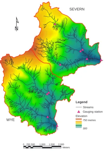
At the start of the research programme, in the mid-1960s, a special aerial survey was commissioned to produce stereo aerial photographs of the catchments. Interpretation of the photographs using photogrammetric techniques provided detailed topographic maps at 1:5000 scale, including the main stream channels, main forest drains, tracks and fence lines. Recently these maps were digitised so that a digital terrain model (DTM) on a 5 m grid (Fig. 1) was produced. With the basic topographic data held on a GIS, it is easy to analyse and compare the catchments features (Table 1). The gridded data may be manipulated to produce detailed maps of a number of potentially hydrologically relevant topographic measures including ground slope (Fig. 2a) and slope direction (aspect) (Fig. 2b) as well as topographic indices. Both catchments have a south-easterly aspect with an altitude range from about 300700 m and a mean altitude of about 450 m. The Severn has a greater proportion of low gradient (<5o) and steep slopes (>15o) than the Wye,
reflecting the bowl-like lower Severn and the plateau-like upper Severn respectively. Differences in topography can be important for hydrology. Altitude affects precipitation (Hudson et al., 1997), evaporation (Blackie and Simpson, 1993) and influences local soil moisture and runoff, as well as vegetation and chemical processes (e.g. due to differences in temperature). Slope angle will affect soil properties due to erosion and deposition. Slope aspect will also influence climatic variables including rainfall (depending on wind direction) and incident radiation, so that on opposite sides of a valley different rates of biochemical processes may
The relation of physical attributes of the Plynlimon catchments to variations in hydrology and water status # * # * # * # * # * # * # * # * # * # *
¹
Legend Streams # * Gauging station Elevation 750 metres 300 SEVERN WYE 0 250500 1,000 1,500 2,000 MetersTable 1. Summary of the main catchment attributes derived from
the GIS. WYE SEVERN ELEVATION (m) Mean: 495 500 Min: 344 328 Max: 742 739 Standard deviation: 86.9 95.3 SLOPE (degrees) Mean: 11.0 11.4 Min: 0.01 0.11 Max: 56.9 37.4 Standard deviation: 6.58 5.58 SOILS (% area) Colluvium 25.6 12.8 Boulder clay 23.6 23.6 Head 21.7 11.2 Hilltop peat 35.1 52.4
Fig. 1. Altitude and stream network of the Plynlimon catchments (based on Hunting Survey, June 1967, © NERC)
¹
SEVERN WYE Legend Streams Slope 30 degrees 0 0 250500 1,000 1,500 2,000 Meters¹
SEVERN WYE Legend Streams Aspect 360 0operate. Topographic indices can also be important diagnostic indicators of local patterns of soil water variability, and will be used in conjunction with surveys of soil properties to study hydrological response zones. Currently, a network of anemometers is being used to apply the DTM to study topographic controls on potential evaporative demand.
When the stream networks were digitised, the natural (topographically controlled) channels were distinguished from artificial drainage channels associated with forestry or derelict mine workings. Analysis of the stream slopes indicates a broad similarity between the two main catchments but spatial variations occur within them; for example, in the Severn catchments, the magnitudes of the slopes of the main channels of the sub-catchments differ in the order: Tanllwyth > Hore > Hafren. The channel geometries of river banks and beds have been described using an archive of photographs. The geometry of both streams varies considerably along their lengths, especially where the streambeds lie over exposed bedrocks of slates, mudstones and sandstones. Geomorphological studies in the Hafren forest at Plynlimon indicate that stream sediment loads (suspended and bed load) are 36 times greater than for the grass Wye catchment, due largely to erosion of the forest drains post planting.
Soil distribution
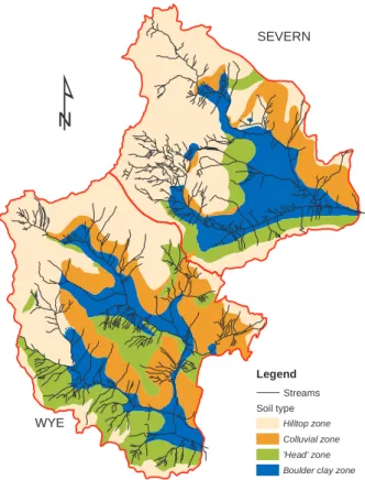
Field investigation in the catchments showed that the existing soil maps were not sufficiently detailed and of limited relevance to hydrological processes. Standard soil classification schemes are necessarily multi-purpose and are often based on features that are the most easily recognisable rather than those that are genetic or functional. Whilst broad links exist between standard soil classes and hydrological behaviour (e.g. Boorman et al., 1995), such relations tend to break down at smaller scales. A special soil survey of both catchments was conducted in 196970 at the beginning of the Plynlimon study (Bell, unpublished data). At that time, many of the forest trees were still small and there was a considerable number of freshly-cut soil profile exposures along the new network of access roads built to service the instrument networks. The soils were classified in terms of profile features indicating their principal hydrological processes, particularly water flowpaths. This classification recognises, for example, that most hydrological activity takes place in the upper layers of the soil often above an impeding layer such as a hard pan, or in the acrotelm of a peat. Up to now, only a part of this survey has been published (Bell, 1972) and the opportunity was taken for this paper to obtain and digitise the complete map (Bell, pers. comm.) at 1:10 000 scale (Fig. 3). Due to its uniform geology and
parent material, the Plynlimon area offers an ideal situation for relating soil type and soil hydrology to topography. There is a strong association between topographic position (slope angle, convexity or concavity, aspect) and distinctive sets of hydrological processes characteristic of each horizon in the soil profile. Broadly, at Plynlimon these groups comprise:
colluvium, developed from rock weathering, on south facing
slopes; boulder clay, left by glaciations on valley bottoms;
glacial head, developed from frost-shattered mudstones,
especially on upper and middle slopes; together with areas of hilltop peat. The potential for using landscape analysis in soil classification is under further investigation. In addition to this map, the Forestry Commission (FC) produced a soil map of the forested area in the Severn catchment according to their site type classification system (Pyatt, 1977). Although essentially a land capability classification for forest planting, this utilises a number of physical attributes that are closely related to soil hydrology such as the site drainage, its parent material and the effective soil rooting depth. The FC soil map was digitised and when overlaid on the hydrological soils map there was a good degree of agreement between many of the categories. For example, the FC class hill peat corresponds to the hill top peat zone, whilst the FC deep peaty gley dominates with respect to the boulder clay zone.
¹
SEVERN WYE Legend Streams Soil type Hilltop zone Colluvial zone ’Head’ zone Boulder clay zoneThe relation of physical attributes of the Plynlimon catchments to variations in hydrology and water status
Vegetation cover
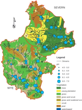
Several vegetation maps of different degrees of complexity are available for the catchments and only the most simplified map is shown here (Fig. 4). Other maps were produced by the Countryside Commission for Wales (CCW), which conducted vegetation surveys of the Wye catchment and the unplanted areas of the Severn. Newson (1976) used a mix of existing maps and field survey and subdivided the moorland vegetation into three communities grasslands, mires and heaths. Grassland covers the largest area, principally Festuca and Nardus. These characterise the long, well drained slopes with podzolised soils. Mires are mostly located in the valley bottoms and the commonest species are Juncus (rushes) and Eriophorum (cotton grass). The heathlands are dominated by Eriophorum, in association with Vaccinium, Calluna or Nardus. Parts of the south-west of the Wye catchment (Cyff subcatchment) have been subject to land improvement techniques including some cultivation and drainage, and the application of lime (Newson, 1976).
The forested area is managed by Forestry Enterprise (FE), which provided detailed information on the extent of forest plantations in the Severn catchment, including tree species and dates of planting and felling. The forest plantation is managed in blocks (coupes); these were digitised and their attributes recorded, and they were compared with the maps
of physical attributes such as soils, topography and climate. These confirm linkages, for example, the dominance of Sitka spruce on wet, peaty, exposed sites. The trees are managed on a forest rotation cycle of about 40 years. Like many British forests, the trees in the Hafren are now reaching the felling stage or have been cut. Felling of the first rotation trees commenced in the 1980s, by the two common harvesting practices of stem and whole tree harvesting. In accordance with general practice and the prevailing industry guidelines (FC, 1993) the forest is cut and then replanted in smaller coupes to create new woodland with a greater diversity of species and ages. Table 2 summarises the age distribution of forest in the Severn catchment, comprising the remaining trees of the first rotation crop that have yet to be cut, together with those areas that have been felled and replanted with second rotation trees.
Stream data
Detailed hydrological studies from the late 1960s have shown that the catchments have a very flashy flow regime with rapid increases in streamflow following storm rainfall and low baseflows in dry weather periods. There are clear differences in annual streamflow between forested and unforested catchments, due to higher evaporation rates from the forest canopy. Although annual streamflow in the Severn is reduced by several hundred mm no differences could be readily attributed to a vegetation effect on baseflow rates or recessions (Kirby et al., 1991). Studies at the catchment and plot scale indicate that areas of fractured bedrock can act as important flow sources. Such fractures are highly heterogeneous in nature (Neal et al., 1997a; Haria and Shand, 2004). Hydrochemical studies have been conducted in both catchments since the early 1980s and include weekly water samples for major, minor and trace elements, in addition to specific research studies (Reynolds et al., 1986, 1989; Hill and Neal, 1997). Water quality patterns are
¹
SEVERN WYE Legend Streams Vegetation trees young plantation grass grass and scrub grass and scattered scrub scrubpeat waterlogged
Table 2. Summary of planting dates of the standing crop in Spring
2000 in the Severn catchment. The current forest is a mix of first rotation forest and the areas that have been felled and replanted with second rotation forest.
First rotation Area (ha) Second rotation Area(ha)
193540 0.1 198185 31 194145 30 198690 91 194650 71 199195 26 195155 0 199699 70 195660 12 196165 164 196680 0
complex both in time and space because of factors such as flashy hydrological processes, the episodic nature of atmospheric deposition, complex water-rock interactions and uncertainties in the locations and sizes of groundwater stores. Such heterogeneity can be presented either directly or by using models with GIS analysis. The stream water chemistry of the grassland Wye is influenced partly by the rainfall chemistry, with relatively high Cl and SO4, and partly
by areas of agricultural improvement by lime addition which increases pH, alkalinity and Ca concentrations. The mainly forested Severn shows additional effects due to the coniferous forest, with low pH, high Al and temporary high NO3 concentrations related mainly to forest harvesting
activities. In fact, the upper Severn is one of the most acidic areas in Wales (Monteith and Evans, 2000).
Comparison of the physio-chemical status of two subcatchments, the forested Hafren and the grassland Gwy, provides indications of the impact of vegetation cover on water chemistry and its physical state (e.g. Reynolds et al., 1989). The Hafren is more acidic and has over double the nitrate concentrations of the Gwy (Reynolds et al., 1986. It also has a much poorer biological status; for example the Hafren has a brown trout density of about 0.12 m-2 compared
with 0.32 m-2 for the Gwy. However, land cover is only one
of several factors controlling water chemistry; for example, in the region where the two catchments touch, the bedrock contains mineral veins and there are mounds of calcite rich waste from derelict mine workings along the Nant Iago and Hore watercourses. Mineralisation results in buffering of streamwater pH in these catchments. In the southern Wye, land management (agricultural improvement including liming) in the Cyff subcatchment together with mineralisation of natural CaCO3 veins within the catchment
bedrock has led to raised stream pH levels (Reynolds et al., 1986). The stream pH falls during storm periods when acidic surface waters reach the stream, and during baseflow periods stream pH and calcium concentrations reach a maximum. Figure 5 shows the findings of a synoptic survey of stream
baseflow pH at 80 sites in June 1996 overlain on the
vegetation cover; there is no evidence of greater acidity under a forest cover. The pattern in baseflow water chemistry is determined by factors that include old mine workings and mineral veins. Where such features are known they will be added to the Plynlimon GIS as an important tool to help demonstrate and explore these relationships.
Characterisation of catchments water
status
The European Commission has made water protection one of its priorities. The European Unions Water Framework
Directive (WFD) has provided a major advance and impetus
in the assessment of water status and the management of aquatic ecosystems. Its principal objective is the achievement of good ecological status of water bodies in all member states by 2016. The major change of approach in this Directive from previous water policy legislation is to assess surface waters using ecological standards (in terms of biological, hydro-morphology and physio-chemical parameters) as well as conventional water chemical determinands (such as acidity, nutrients and heavy metals). The WFD provides a legislative framework within the context of the sustainable development of water resources, through the production of River Basin Management Plans (RBMPs). These attempt to prioritise the interrelated and often competing needs of farming, forestry, leisure (including fishing) and conservation. The procedures proposed for the WFD involve the protection of sites of high ecological status , maintenance and enhancement of sites of good status, and enhancement of sites of poor status. The WFD also allows for the designation of areas of conservation interest (e.g. SSSIs and SACs) where the status of their waters is an important factor in the protection of habitats and species. There are currently two SSSIs in the
¹
SEVERN WYE Legend Streams pH 4.5 - 5.0 5.1 - 5.5 5.6 - 6.0 6.1 - 6.5 6.6 - 7.0 Vegetation trees young plantation grass grass and scrub grass and scattered scrub scrubpeat waterlogged
The relation of physical attributes of the Plynlimon catchments to variations in hydrology and water status study catchments, the Plynlimon massif, which contains the
upper parts of both catchments and includes the high altitude western part of the Hafren forest, and the river Wye SSSI that contains the stream channels of the Cyff and Gwy.
The WFD requires the definition of reference conditions with relatively minor disturbance (not necessarily pristine) against which actual conditions are judged, following guidance from several Working Groups (e.g. REFCOND, 2002). The Plynlimon catchments, where many of the necessary environmental data are already available, provide an opportunity to investigate and demonstrate the application of GIS to RBMPs. There have been periodic surveys of aquatic biology including fish and stream invertebrates since the early 1980s (Crisp and Beaumont, 1997; Gee and Smith, 1997). Several surveys of the terrestrial fauna have also been conducted, including birds, invertebrates and butterflies of the Hafren forest. In terms of water quality and resources, the data from the Plynlimon catchments generally meet the WFDs requirements. The physio-chemical status of the two catchments was based on measurements available for the two representative sub-catchments, the Hafren and the Gwy. This indicates broadly good status for the Wye, but poor for the Severn. Regarding the river habitat, the river morphology of the Severn is significantly modified by forestry activities, whereas the Wye has reference or pristine conditions. Species composition seems to suffer from forestry operations, with clear evidence of land use impacts on fish populations.
In assessing the ecological status of the Plynlimon catchments the following points must be considered:
l the morphological conditions are very similar but the
ecological status differs due to the land use;
l the hydrological regime and water yield of the Severn
are affected by the forested area and the clearfelling;
l the chemical status of the stream waters in the Wye is
affected by rainfall chemistry, mineralisation and grassland improvements, whereas the Severn is characterised, particularly at high flows, by conifer-enhanced soil acidity.
One of the key basics in the WFD is an understanding of the interrelations between hydrological, hydrochemical, morphological and biological aspects that define ecological status on the one hand, and their relation and response to pressures such as land use and land management. An important aspect of the development of the RBMPs is the participation of the general public within the planning process. GIS techniques can play a key role in the presentation of complex spatial information for catchment management purposes in a way that is clear and simple for
non-specialist laypeople to understand, especially when trying to reconcile the complex arguments of vested interests and lobby groups (Brandt, 2002).
Hypothetical management scenarios for the Plynlimon catchments
The potential land uses in the catchments are limited by the high precipitation, the prevailing peaty and podzolised soils, and the steep slopes. Agriculture is largely restricted to grazing. This paper demonstrates some individual elements of the development of a hypothetical RBMP to address the sustainability of water resources, good water quality, enhanced state of biodiversity and the reduction of negative impacts due to land use. An illustrative model approach presented here takes just two aspects, the impact of forestry management in the Severn on water resources and the manipulation of water chemistry by the application of liming to unforested streams.
Hydrological measurements at Plynlimon have shown that afforestation increases evaporative losses, and the magnitude of the impact can be described by a simple process-based linear model (Calder and Newson, 1979). Therefore, if the quantitative influence of forestry on water resources can be linked to changes in forest area it is possible to make predictions about future water resource changes due to felling. Forest Enterprise (FE, 1998, 2000) has produced plans for felling and restocking that extend to the year 2026 (Fig. 6a). If, following felling, the ground remains devoid of vegetation for about three years until it is replanted and rank herbal species grow up though the brash (Robinson and Dupeyrat, 2004), the planned felling in 20022006 may result in an increase in average annual streamflow of almost 50 mm. When felling rates are expected to peak in 2022 26, the average annual flow is predicted to increase by over 200 mm.
However, whilst forestry felling may enhance water resources (quantity) at least in the short-term (Robinson and Dupeyrat, 2004), it could have serious negative impacts on water quality as well as on flora and fauna. This includes increased sediment loads and nitrate pulses (e.g. Neal et
al.,1997b). In felled areas that are not to be restocked,
attention must be given to prevent self-seeding of neighbouring conifers and to encourage regeneration of native (i.e. broadleaf) species. One forest management option is to limit the area that is cut each year, so as to restrict the peak losses of sediment or nitrate. In the scenario shown in Fig. 6b, the planned annual average felling rate has been halved from the 21 ha yr1 planned by FE to 11 ha yr1 and
shows the change to the planned age structure. Other management measures which might be adopted include the management of cleared ground for enhanced soil chemistry
poor forest soils is commercially unacceptable since it can suppress tree growth for between 5 and 20 years by reducing the soil nitrogen supply to the forest crop. The most effective way of ameliorating the acidity of surface waters is to apply a fine powdered limestone to the boggy, usually unplanted, source areas in the headwater regions of sensitive catchments. Direct application of liming can however represent a threat to remnant mire complexes and must be done with care. Figure 7 illustrates how it could be used in a restricted way in both catchments. Of course, in practice, such work should not be carried out in isolation; these areas need conservation too (rehabilitation), and any management plan should incorporate additional measures such as a reduction of sheep grazing intensity, banning vehicles and possibly re-routing public footpaths.
The Forestry Commission has produced a number of
Guidelines detailing environmental standards to be applied
in its own forests and private forests receiving government grant-aid (FC, 1990, 1993, 2003). These include the introduction of unplanted forest edge buffer zones to reduce adverse forest impacts due to soil drying and chemical changes. Areas of poor tree growth may be left open and allowed to revert to bog communities under the present wet climate. Heath restoration may be encouraged by limited
¹
Legend Streams Liming of streams liming recommended liming from 2026 on liming from 2031 on Vegetation trees young plantation grass grass and scrub grass and scattered scrub scrub peat waterlogged SEVERN WYE 0 250500 1,000 1,500 2,000 MetersFig. 6. Forest change maps; (a) Forest Enterprise felling plans to 2026, (b) Hypothetical alternative felling plan (see text for details)
Proposed felling restocked 2006 2011 2016 2021 2027
Revised proposed felling
Felled + restock fell to 2011 fell to 2016 fell to 2021 fell to 2026 fell to 2031 fell to 2036 fell to 2041 fell to 2046 fell to 2050 a) b)
and conservation, and the exclusion of forestry from acid-sensitive areas.
Water quality can be improved in the Hafren forest by a shift to more broadleaved trees (to reduce acidification) and smaller felling areas to produce a more diverse age structure (to reduce peak levels of sediment and nitrate releases). The speed with which the overall forest composition can be changed is constrained by limits on the size of felling area and on the need to wait until the trees are economically mature. Thus, it is likely that only limited improvements in ecological status of the Severn could be achieved by the end of 2016. Only when the forest restructuring is complete in 2056 would the ecological status achieve a high level with semi-natural conditions.
Another way to improve water status is by the application of lime to ameliorate stream acidity and prevent downstream
The relation of physical attributes of the Plynlimon catchments to variations in hydrology and water status
grazing and burning to constrain certain species. With the present dominance of uniform plantation conifers there is no short-term alternative for cutting except by clear felling. Over time it may be possible to move to a system of continuous cover forestry whereby the forest canopy is maintained at one or more levels (trees, shrubs).
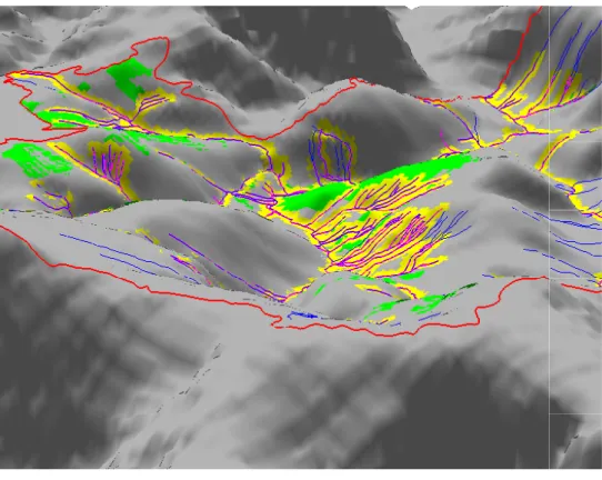
The use of GIS to present the impacts of differing management options is a powerful aid to the planning process. Information can be analysed and manipulated to help decisions and can be output in various formats making it easier to present and discuss proposals. Figure 8, for example, shows in 3-D form a visualisation of how buffer zones linked to improved areas of the landscape may be presented to local stakeholders in a form that would be readily recognisable and meaningful.
Three aspects of management to be considered for the two catchments are:
l nature conservation: this requires a coherent mosaic of
species and habitats;
l farming: farming grants should help to maintain
traditional conservation practices, and encourage grazing and soil rehabilitation on areas where forestry has stopped;
l forestry: there must be a shift to a more diverse forest
structure to reduce negative impacts on water resources, water quality, soil and biodiversity, and to achieve a good ecological status.
Conclusions
This paper presents major progress to establish a high quality GIS to describe the main physical features of the Plynlimon research catchments. It indicates how these data are being used to provide insights into catchment processes that may underpin the development of new research, including spatial variations in evaporative demand, identifying hydrologically active zones and linking topography to soil hydrological processes and water chemistry. The paper presents an outline of progress to date and serves as a flag for what might be
Fig. 8. 3-D visualisation showing buffer zones to reduce stream nitrates due to areas of improved pasture in the Wye (vertical scale exaggeration of 3-times). Looking southeastwards down the Wye catchment (with the Gwy tributary in the middle and the Cyff to the right).
Legend
Catchment boundary Streams
Streams potentially affected 30 m buffer around affected streams Improved grassland
achieved in the future, given proactive support and innovative collaboration. It also illustrates the potential of GIS techniques for catchment management to present complex environmental information in a form that is transparent and accessible to non-specialist stakeholders who may be involved in a comprehensive planning process.
Acknowledgements
The authors would like to thank the following for the provision of data described in this paper Jim Ralph, Paul Stevens and John Bell. Much of the digitisation of catchments maps was undertaken by Emma Cowley. The management scenarios shown here are illustrative and do not represent actual current land use policy.
References
Bell, J.P., 1972. A preliminary appraisal of the soil hydrology of the Wye catchment on Plynlimon in: Current research on Welsh soils, Welsh Soils Discussion Group, Report No.13, Aberystwyth, Wales.
Blackie, J.R. and Simpson, T.K.M., 1993. Climate variability within the Balquhidder catchments and its effect on Penman potential evaporation. J. Hydrol., 145, 371387.
Boorman, D.B., Hollis, J.M. and Lilly, A., 1995. Hydrology of Soil Types: a hydrologically based classification of the soils of the UK. Institute of Hydrology Report 126.
Brandt, C., 2002. Creation of River Basin Development and
Management Plans by using GIS. Unpublished thesis. Technical
University, Munich.
Calder, I.R. and Newson, M.D., 1979. Land use and upland water resources in Britain a strategic look. Water Resour. Bull., 16, 16281639.
Crisp, D.T. and Beaumont, W.R.C., 1997. Fish populations in Plynlimon streams. Hydrol. Earth Syst. Sci., 1, 541548. EA, 1999. Local Environment Action Plan: Severn uplands.
Environment Agency, Bristol, UK.
EA, 2000. Local Environment Action Plan: Wye area. Environment Agency, Bristol, UK.
FC, 1990. Forest Nature conservation Guidelines. Forestry Commission HMSO, London, UK.
FC, 1993. Forests and Water Guidelines, 3rd Ed. Forestry
Commission HMSO, London, UK.
FC, 2003. Forests and Water Guidelines, 4th Ed. Forestry
Commission HMSO, London, UK.
FE, 1998., Canolbarth Forest District Conservation Plan
Schedule of sites of wildlife conservation value. Forest
Enterprise. Unpublished.
FE, 2000., Plynlimon (Hafren) SSSI: management agreement for
Forestry Commission land 14.04.00 13.04.05, Forest
Enterprise. Unpublished.
Gee, J.H., and Smith, B.D., 1997. Benthic invertebrates in the headwaters of the Wye and Severn: effects of forestry and clear-felling. Hydrol. Earth Syst. Sci., 1, 549556.
Haria, A. and Shand, P. 2004. Evidence for deep subsurface flow routing in forested upland Wales: implications for contaminant transport and stream flow generation. Hydrol. Earth Syst. Sci.,
8, 334-344.
Hill, T. and Neal, C., 1997. Spatial and temporal variation in pH, alkalinity and conductivity in surface runoff and groundwater for the Upper River Severn catchment. Hydrol. Earth Syst. Sci.,
1, 697715.
Hudson, J.A., Crane, S.B. and Blackie, J.R., 1997. The Plynlimon water balance 1969-95: the impact of forest and moorland vegetation on evaporation and streamflow in upland catchments.
Hydrol. Earth Syst. Sci., 1, 409427.
Kirby, C., Newson, M.D. and Gilman, K. 1991. Plynlimon research: The first two decades, Institute of Hydrology Report
No. 109, Wallingford, UK.
Monteith, D.T. and Evans, C.D. (Eds), 2000. UK Acid Waters
Monitoring Network (UKAWMN), 10 year report, Analysis and
interpretation of the results April 1988 March 1998, London, Neal, C. (Ed.), 1997. Water quality of the Plynlimon catchments
(UK). Hydrol. Earth Syst. Sci., Special Issue, 1, 381763. Neal, C., Robson, A.J., Shand, P., Edmunds, W.M., Dixon, A.J.,
Buckley, D.K., Hill, S., Harrow., Neal, M., Wilkinson, R.J. and Reynolds, B., 1997a. The occurrence of groundwater in the Lower Palaeozoic rocks of upland Cental Wales. Hydrol. Earth
Syst. Sci., 1, 318.
Neal, C., Wilkinson, R.J., Neal, M., Harrow, M.L., Wickham, H., Hill, L. and Morfitt, C., 1997b. The hydrochemistry of the River Severn, Plynlimon, Wales. Hydrol. Earth Syst. Sci., 1, 583618.
Newson, M.D., 1976. The physiography, deposits and vegetation of the Plynlimon catchments. Institute of Hydrology Report 30. Wallingford, UK.
Newson, M.D., 1979. The results of ten years experimental study on Plynlimon, mid-Wales, and their importance for the water industry. J. Inst. Water Eng. Sci., 33, 321333.
Painter, R.B., Rodda, J.C. and Smart, J.D.G., 1972. Hydrological research and the planner. Surveyor, 1, 4 pp.
Pyatt, D.G., 1977., Guide to site types in forests of North and Mid Wales. Forestry Commission Record No 69. HMSO, London, UK. 51pp.
REFCOND, 2002. Guidance on establishing reference conditions
and ecological status class boundaries for inland surface waters.
(Working Group 2.3 of WFD), www-nrciws.slu.se/REFCOND/ Reynolds, B., Hornung, M. and Hughes, S., 1989. Chemistry of streams draining grassland and forest catchments at Plynlimon, mid-Wales. Hydrolog. Sci. J., 34, 667686.
Reynolds, B., Neal, C., Hornung, M. and Stevens, P.A., 1986. Baseflow buffering of stream water acidity in five mid-Wales catchments. J. Hydrol., 87, 167185.
Robinson, M. and Dupeyrat, A., 2004. Effects of commercial timber harvesting on streamflow regimes in the Plynlimon catchments, mid-Wales. Hydrol. Process., 18, (in press). Robson, A., Beven, K. and Neal, C., 1992. Towards identifying
sources of subsurface flow: a comparison of components identified by a physically-based runoff model and those determined by chemical mixing techniques. Hydrol. Process.,