HAL Id: tel-01468804
https://tel.archives-ouvertes.fr/tel-01468804
Submitted on 15 Feb 2017
HAL is a multi-disciplinary open access
archive for the deposit and dissemination of sci-entific research documents, whether they are pub-lished or not. The documents may come from teaching and research institutions in France or abroad, or from public or private research centers.
L’archive ouverte pluridisciplinaire HAL, est destinée au dépôt et à la diffusion de documents scientifiques de niveau recherche, publiés ou non, émanant des établissements d’enseignement et de recherche français ou étrangers, des laboratoires publics ou privés.
paleoenvironmental changes in the northern South
China Sea
Quan Chen
To cite this version:
Quan Chen. Detrital signatures of Late Quaternary paleoenvironmental changes in the northern South China Sea. Global Changes. Université Paris Saclay (COmUE); Tongji university (Shanghai, Chine), 2016. English. �NNT : 2016SACLS492�. �tel-01468804�
NNT : 2016SACLS492
T
HESE DE
D
OCTORAT
DE
L
’U
NIVERSITE
T
ONGJI
ET DE
L
’U
NIVERSITE
P
ARIS
-S
ACLAY
PREPAREE A L
’U
NIVERSITE
P
ARIS
-S
UD
ÉCOLE DOCTORALE N°579
Sciences mécaniques et énergétiques, matériaux et géosciences (SMEMaG)
SCHOOL OF OCEAN AND EARTH SCIENCE
Spécialité de doctorat : météorologie, océanographie, physique de l'environnement
Par
M. Quan CHEN
Signatures détritiques des changements paléoenvironnementaux du Quaternaire
récent dans le bassin nord de la Mer de Chine du Sud
Thèse présentée et soutenue à Shanghaï
, le 8 decembre 2016 :
Après avis des rapporteurs :
Mme France Lagroix (Chargé de Recherche, IPGP) M. Liping Zhou (Professeur, Université de Pékin)
Composition du Jury :
M. Pinxian Wang Professeur, Université Tongji Président du Jury M. Liping Zhou Professeur, Université de Pékin Rapporteur M. Christophe Colin Professeur, Université Paris-Sud Examinateur Mme Stéphanie Duchamp-Alphonse Maître de Conférence, Université Paris-Sud Examinatrice
M. Zhimin Jian Professeur, Université Tongji Examinateur
Mme Catherine Kissel Eq. Directrice de Recherche, CEA Directrice de thèse M. Zhifei Liu Professeur, Université Tongji Directeur de thèse
A dissertation submitted to
Tongji University and University Paris-Saclay
in conformity with the requirements for
the degree of Doctor of Philosophy
December, 2016
Candidate: CHEN Quan
Affiliation: School of Ocean and Earth Science, Tongji University
École Doctorale 579, Université Paris-Saclay
Discipline: Science
Major: Ocean Science
Supervisor: Prof. LIU Zhifei
Prof. KISSEL Catherine
December, 2016
Detrital signatures of Late Quaternary
paleoenvironmental changes
博士学位论文
南海北部晚第四纪古环境变化的
陆源碎屑指标
姓 名:陈全
学 号:1110690
所在院系:同济大学海洋与地球科学学院
巴黎萨克雷大学气候与环境科学实验室
学科门类: 理学
学科专业: 海洋科学
指导教师: 刘志飞 教授
KISSEL Catherine 教授
二〇一六年十二月
Signatures détritiques des changements
paléoenvironnementaux du Quaternaire récent
dans le bassin nord de la Mer de Chine du Sud
Résumé
La mer de Chine du Sud est un laboratoire naturel pour beaucoup d'aspects. Elle
est entourée par le continent asiatique, où se trouvent trois des plus grands fleuves du
monde et et de nombreuses îles avec des rivières montagneuses qui fournissent une
très grande quantité de sédiments terrigènes à la mer de Chine du Sud (Milliman et
Farnsworth, 2011). En mer, les sédiments terrigènes sont transportés par divers
courants qui sont liés aux vents de mousson sud-est asiatique, à l'intrusion du courant
de Kuroshio et à l'échange d'eau profonde avec le Pacifique. Les sédiments terrigènes
déposés en mer de Chine du Sud portent donc des signaux mixtes d'environnement
continental et de transport océanique, faisant de cette mer un laboratoire naturel pour
étudier les processus depuis la source jusqu'au dépôt (Liu et al., 2016).
Sur le continent, les conditions climatiques jouent un rôle de premier plan dans la
formation des minéraux. Comme la mer de Chine du Sud se situe à basse latitude sur
le côté ouest du Pacifique, la mousson sud-est asiatique est la caractéristique
climatique dominante (Webster, 1987; Zahn, 2003). La mousson est caractérisée par
des changements saisonniers dans la direction du vent et dans l'humidité. Lors de la
mousson d'été asiatique, l'humidité est transportée de l'océan vers le continent, tandis
que la mousson d'hiver asiatique s'accompagne d'une aridité à terre (Chu et Wang,
2003). L’intensité de la mousson est principalement contrôlée par les changements
d'insolation liés au forçage orbital, et les conditions climatiques de cette région sont
donc variables à l'échelle de temps orbitale. En outre, le changement climatique global
à l'échelle glaciaire-interglaciaire joue également un rôle dans l'environnement
régional non seulement en influençant le climat local, mais aussi en modifiant la
répartition terre-mer. En effet, au cours des périodes glaciaires, lorsque les calottes
glaciaires se développent et que le niveau de la mer descend, le plateau continental est
émergé ainsi que la plupart des détroits. Etant donnée la très grande taille des marges
continentales en Mer de Chine du Sud, cette situation modifie considérablement la
répartition terre-mer, En conséquence, les transports fluviatiles et les circulations
océaniques s'en trouvent modifiés, ce qui entraîne un schéma différent de dépôt de
sédiments terrigènes au cours des périodes glaciaires (Huang et al., 1999, Liu et al.,
2003, Wang et al., 1995).
Afin de mieux comprendre comment les changements paléoenvironnementaux
sont enregistrés dans les sédiments marins et proposer des traceurs appropriés pour
reconstruire leur évolution à différentes échelles de temps, nous avons étudié à haute
résolution et en multi-paramètres une séquence de sédiments, la carotte MD12-3432,
prélevée au nord de la mer de Chine du Sud lors de la campagne franco-chinoise
CIRCEA à bord du R/V Marion Dufresne. L'étude a porté sur la minéralogie argileuse,
les propriétés magnétiques, les éléments majeurs et la granulométrie sédimentaire.
La première phase de mes travaux a concerné les résultats obtenus sur la
composition en éléments majeurs du sédiment total dans la séquence MD12-3432.
Cette composition a été mesurée à l'aide d'un scanner XRF car c'est un instrument
rapide et la masure est non destructive. Cependant, des questions controversées ont
été soulevées au sujet de la fiabilité des données obtenues, car le XRF core-scanning
mesure des intensités élémentaires semi-quantitatives qui peuvent être influencées par
divers facteurs, tels que la teneur en eau, la granulométrie et l'effet de matrice
(Hennekam Et de Lange, 2012, Löwemark et al., 2011; Lyle et al., 2012; Tjallingii et
al., 2007; Weltje et al., 2015; Weltje et Tjallingii, 2008). Nous avons comparé les
résultats obtenus par scan avec les résultats obtenus quantitativement par WD-XRF et
nous avons calculé les coefficients de corrélation linéaire et les erreurs relatives. En
termes de données brutes de XRF-scanning, la corrélation avec les mesures de
WD-XRF est modérée à élevée pour la plupart des éléments sauf pour Al et Si qui ont
des erreurs relatives plus élevées en partie haute de la séquence qu'en partie basse. Les
calibrations existantes améliorent les corrélations mais la tendance à long terme
d’erreur relative est encore observée. Il apparaît que la diminution de la teneur en eau
interstitielle est le facteur principal qui dévie de manière préférentielle les données de
XRF-scanning des éléments légers et que les méthodes existantes ne peuvent pas
corriger totalement cet effet. Afin de mieux prendre en compte cet effet, nous avons
proposé une correction polynomiale pour les données brutes de XRF-scanning et nous
l'avons implémenté dans les deux méthodes existantes. Les résultats calibrés par ces
deux méthodes améliorées montrent une meilleure corrélation avec les mesures
WD-XRF et des erreurs relatives des moindres carrés très faibles. La tendance à long
terme n'est plus observée dans les erreurs relatives. Ces méthodes de correction des
données XRF sont donc les plus appropriées pour les séquences de sédiments longs
avec des variations de la teneur en eau interstitielle. Ces méthodes de calibration
fournissent au moins des enregistrements robustes de la composition en éléments
majeurs de la carotte MD12-3432 pour des études paléoenvironnementales (Chen et
al., 2016).
Sur la base de la calibration des données XRF-scan, un enregistrement à haute
résolution de la teneur en carbonate de calcium de la carotte MD12-3432 a permis de
transférer celle-ci sur le cadre chronologique du site ODP 1146 (Clemens et al., 2008,
Caballero-Gill et al. 2012). Ce modèle d'âge préliminaire a été ensuite affiné grâce
aux variations de l'intensité du champ magnétique terrestre. En effet, dans la carotte
MD12-3432, les variations du champ magnétique terrestre sont enregistrées de
manière fiable avec une inclinaison moyenne de 34,7 ± 9,4 °, cohérente avec celle
attendue à cette latitude sur l'hypothèse d'un dipole axial centré (34,9°). La
déclinaison magnétique est également stable et la direction du champ est définie à
mieux que 10°. La paléointensité relative du champ magnétique terrestre enregistrée
est donc utilisée pour préciser le modèle d'âge en corrélant l'enregistrement dans la
carotte MD12-3432 avec la courbe de référence globale PISO-1500 (Channel et al.,
2009). Des points de corrélation sont ainsi ajoutés aux minima de paléointensité, en
particulier ceux associés à l'excursion de Laschamp à 40 ka et à l'excursion de Blake à
95 et 120 ka. Le modèle d'âge indique que la sequence sédimentaire MD12-3432
couvre les derniers 404 mille ans avec un taux de sédimentation moyen d'environ 12,6
cm/kyr.
Comme l'altération chimique modifie principalement la composition des
éléments, l'enregistrement à haute résolution des éléments majeurs calibrés est utilisé
pour évaluer l'évolution de l'altération à la fin du Quaternaire. Le résultat montre que
les teneurs de tous les éléments terrigènes ont des variations semblables, opposes à
celle du carbonate de calcium biogénique. Pour mieux illustrer le signal d'altération, le
rapport K
2O/Al
2O
3est utilisé parce que le potassium est plus mobile que l'aluminium
et que l'effet granulométrique est négligeable puisque les deux éléments sont
principalement transportés par des minéraux argileux dans cette zone. Par conséquent,
un faible rapport K
2O/Al
2O
3indique que le sédiment total a subi une forte altération
chimique. Dans la carotte MD12-3432, le rapport K
2O/Al
2O
3présente une périodicité
d'excentricité dominante avec des augmentations pendant les interglaciaires, ce qui
indique que l'altération continue à s'affaiblir pendant les interglaciaires. Cela contraste
avec la compréhension antérieure que l'altération est renforcée par le climat chaud
pendant les interglaciaires. Par conséquent, le degré d'altération du sédiment total, tel
qu'indiqué par le rapport K
2O/Al
2O
3, ne correspond pas à l'altération chimique
contemporaine sur terre et des changements de sources peuvent être invoquées. Les
études préalables des sédiments de rivières ont montré que la fraction détritique
déposée en Mer de Chine du Sud provient principalement du bassin de la rivière des
Perles, de Taïwan et de Luzon (Liu et al., 2008a). Taïwan est la région parmi les trois
qui exporte la plus grande quantité de sédiments (Dadson et al., 2003, Milliman et
Farnsworth, 2011) car l'intense précipitation d'été y augmente le taux de dénudation
des rivières et, ainsi, la contribution relative de la fraction détritique érosive. En raison
de l'érosion physique forte et de l'altération chimique faible, le rapport K
2O/Al
2O
3des
sédiments à Taiwan est plus élevé que celui de Luzon et du bassin de la rivière des
Perles (Selvaraj and Chen, 2006; Chen and Selvaraj, 2007). L'augmentation du
rapport K
2O/Al
2O
3dans les sédiments totaux de la carotte illustre cette forte
dénudation fluviale à Taiwan dans bande spectrale de l'excentricité.
L'altération chimique influe également sur la formation de minéraux argileux à
terre (Chamley, 1989). Dans le cas du nord de la Mer de Chine du Sud, les trois
provenances terrigènes fournissent des minéraux argileux différents en raison de leurs
contextes géologiques et tectoniques. Le bassin de la rivière des Perles a un régime
tectonique stable, une topographie plate et un climat de mousson chaud et humide.
Les roches et les sols du bassin de la rivière des Perles subissent de fortes altérations
chimiques et une érosion physique relativement faible. Ces conditions favorisent la
formation et l'accumulation de sols kaolinitiques qui peuvent prendre plus de 1 Ma à
se développer (Liu et al., 2007; Thiry, 2000). Le sédiment provenant du bassin de la
rivière des Perles est donc riche en kaolinite (Liu et al., 2007). À Taïwan, la
dénudation des rivières est intense en raison de la topographie, de la tectonique active,
et de fortes précipitations de mousson et/ou de passages de typhons (Dadson et al.,
2003; Milliman and Farnsworth, 2011). Les formations sédimentaires et
métamorphiques y sont rapidement érodées. Cette forte érosion physique inhibe
l'altération chimique et favorise la formation et la distribution de minéraux primaires
d'illite et de chlorite (Liu et al., 2008b). Étant donné la similitude des paramètres
tectoniques et climatiques à Taïwan et à Luzon, les fortes précipitations de mousson
peuvent également entraîner une dénudation intense des rivières à Luzon. Cependant,
la géologie de Luzon est dominée par des roches volcaniques qui peuvent être
dégradées rapidement pour former des smectites en abondance (Oliva et al., 2003;
Sasaki et al., 2003; Schopka et al. 2011). L'assemblage minéral argileux de la carotte
MD10-3432 se compose principalement de smectite (23%-59%) et d'illite (22%-43%)
avec de la chlorite (13%-27%) et de la kaolinite (4%-13%). La cristallinité de l'illite
(0,13-0,18 ° Δ2θ) varie dans la plage observée dans les sédiments modernes de
Taiwan. Ces résultats indiquent que (1) l'illite et la chlorite proviennent
principalement de Taiwan et sont formées par l'érosion physique, (2) la smectite
provient de Luzon et est formée par l'altération chimique rapide des roches
volcaniques abondants à Luzon et (3) les kaolinites sont formées par l'altération à long
terme dans le bassin de la rivière des Perles. Par conséquent, la teneur en kaolinite,
habituellement utilisée comme indicateur de l'altération chimique à l'échelle
tectonique reflète ici la contribution relative de l'approvisionnement terrigène de la
rivière des Perles pendant le Quaternaire, tandis que le rapport smectite/(illite+chlorite)
constitue un indicateur de l'altération contemporaine à Luzon. Concernant les
variations temporelles, l'analyse spectrale révèle une périodicité de 100 kyr liée à
l'excentricité dans le rapport smectite/(illite+chlorite) de la carotte MD12-3432 avec
des valeurs élevées pendant les interglaciaires. Il est logique que la température élevée
pendant les interglaciaires favorise l'altération chimique et, par conséquent, augmente
le rapport smectite/(illite+chlorite). Outre la cyclicité glaciaire et interglaciaire, la
caractéristique la plus importante du rapport smectite/(illite+chlorite) de la carotte
MD12-3432 est les fluctuations à court terme avec des valeurs élevées correspondant
à chaque maxima d'insolation estivale dans l'hémisphère nord dans la bande de
précession (23 kyr). Des variations similaires du rapport smectite/(illite+chlorite) ont
également été observées aux sites ODP 1145 et 1146 situés à proximité (Liu et al.,
2003; Boulay et al., 2005), Puisque l'insolation estivale de l'hémisphère Nord est la
force motrice de la mousson d'été asiatique, qui est caractérisée par un climat chaud et
humide favorisant l'altération chimique, ces variations en phase avec la précession
indiquent que le rapport smectite/(illite+chlorite) est un traceur des changements de
l'altération chimique contemporaine provoquée par l'évolution de la mousson d'été
asiatique et, par conséquent, un traceur de la mousson d'été asiatique au Quaternaire.
Tout ceci a fait l'objet d'un article sous presse à Scientific Reports.
La fraction magnétique des sédiments du nord de la mer de Chine du Sud fournit
des informations complémentaires sur les changements environnementaux. Les
propriétés magnétiques à savoir la concentration, la taille et la nature des particules
magnétiques sont variables dans le temps comme illustré par les paramètres de base
(susceptibilité en champ faible (k), aimantations rémanentes anhystérétique (ARM) et
isotherme (IRM)).
Pour mieux comprendre ces variations, nous analysons en détail la nature des
minéraux magnétiques à l'aide de la décomposition Gaussienne logarithmique
cumulée des courbes d'acquisition à haite résolution de l'IRM (Kruivier et al., 2001) et
de la désaimantation thermique de l'IRM sur trois axes. Un mélange de différentes
familles coercitives est reconnu avec une dominance des familles de coercivité faible
à moyenne tandis que la famille de haute coercivité contribue de 3% à 22% à l'IRM à
saturation. Le comportement thermique de ces familles indique que la fraction de
coercivité élevée est composée d'hématite et les familles de coercivité faible à
moyenne sont constituées de magnétite et de sulfures de fer. Puisque qu'aucune
aimantation gyrorémanente (GRM) est observée au cours de la désaimantation de
ARM jusqu'à 80 mT, il est peu probable que les sulfures de fer soient de la greigite.
Nous interprétons donc cette composante comme étant portée par la pyrrhotite qui a
par ailleurs été largement identifiée dans la partie nord de la mer de Chine du Sud, à
Taiwan (Horng et Huh, 2011; Horng et al., 2012).
Des variations aussi bien de la granulométrie sédimentaire que de la teneur en
hématite sont observées à l'échelle de la précession. En effet, des apports importants
d'hématite, en phase avec du sédiment plus fin coïncident avec les minima de
précession. Étant donné que l'hématite n'est pas abondante dans les systèmes
fluviatiles environnants, ces événements se produisant pendant les périodes arides
peuvent illustrer des changements d’apports éoliens venant des déserts de Chine
centrale. Bien que les poussières éoliennes soient principalement transportées vers
l'est par les vents d'ouest de latitude moyenne (Seo et al., 2014), des études antérieures
ont découvert des apports éoliens dans les séquences sédimentaires de la mer de
Philippine (Maher, 2009, Xu et al. Et al., 2016), qui est à la même latitude que notre
site. Deux mécanismes ont été proposés: (1) la mousson d’hiver asiatique intensifiée
livre plus de poussières éoliennes vers le sud (Xu et al., 2014), et (2) les poussières
éoliennes peuvent se disperser vers le sud comme les aérosols (Prospero et al. , 1994)
et retomber avec la pluie liée à la mousson d'été asiatique. Nos résultats montrent que
de forts apports éoliens se produisent simultanément à la faible mousson d'été
asiatique, lorsque la zone de convergence intertropicale migre vers le sud, permettant
à plus d'aérosols d'arriver à basse latitude. En dépit du fait que la poussière éolienne
est une fraction mineure dans les sédiments du nord de la mer de Chine du Sud, nos
résultats suggèrent que la teneur de hématite peut constituer un puissant traceur pour
révéler ces signaux même très faibles et, ainsi, indiquer des changements de l'intensité
de la mousson d'été asiatique.
Outre les changements climatiques de basse latitude, l'activité tectonique et le
climat mondial influencent également la composition terrigène au site étudié à
différentes échelles de temps. Nos résultats montrent des augmentations à long terme
sur 400 000 ans de la teneur en pyrrhotite par rapport à la magnétite et à l'hématite et
de teneurs en illite et chlorite par rapport aux autres argiles. Ces augmentations
indiquent une contribution croissante des sédiments provenant de Taïwan. Cela est
probablement lié à l'intensification de l'orogène taiwanaise sur les derniers 400 000
ans.
Enfin, à l'échelle glaciaire-interglaciaire, les augmentations de la vitesse de
sédimentation, de la teneur en magnétite et pyrrhotite, de la teneur en kaolinite et de la
taille des grains pendant les périodes glaciaires sont attribuées aux changements du
niveau de la mer. Le bas niveau de la mer au cours des périodes glaciaires expose la
vaste marge continentale, rapproche le débouché de la rivière des Perles de notre site
permettant à celle-ci de délivrer plus de sédiments terrigènes plus grossiers à notre
site.
Mots clés : Mer de Chine du Sud, mousson d’été asiatique, changements de niveau
Detrital signatures of Late Quaternary
paleoenvironmental changes
in the northern South China Sea
ABSTRACT
The aim of this study is to reconstruct late Quaternary environmental changes in
the northern South China Sea by applying multi-disciplinary proxies of land-sea
interaction, East Asian monsoon, and oceanic circulation. Investigations of clay and
magnetic mineralogy, major element composition, and grain size were performed on
marine sediment Core MD12-3432 retrieved from the continental slope of the
northern South China Sea. The core covers the last 400 ka with a sedimentation rate
varying between 4.5 and 24 cm/ka.
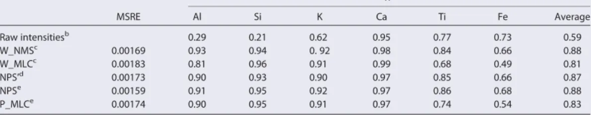
We examined the accuracy of existing calibration methods on major element
composition obtained by XRF core-scanning, because downcore variations in
interstitial water content should strongly affect scanned element contents We proposed
a quadratic polynomial correction to account for this effect and implemented it in the
calibration methods. Data from Core MD12-3432 show that the improved calibration
process now correctly converts XRF core-scanning data into major element
concentrations.
Our results on high-resolution major element composition, clay and magnetic
mineralogy, and grain size data indicate that low-latitude climate changes influence
various terrigenous fractions in different ways.
In bulk sediment, K
2O/Al
2O
3ratio mainly reflects the relative contribution of
detrital supply from Taiwan, and its variation exhibits eccentricity cycles. The ratio
increases during interglacials, showing that strong precipitation and denudation are
induced by enhanced East Asian summer monsoon. In clay fractions,
smectite/(illite+chlorite) ratio presents both eccentricity and precession periodicities,
in phase with the northern hemisphere summer insolation changes and therefore with
the East Asian summer monsoon evolution. Based on the knowledge of sediment
provenances, these results suggest that high smectite/(illite+chlorite) ratios illustrate
contemporaneous chemical weathering intensity in Luzon. It supports the
understanding that East Asian summer monsoon is enhanced during interglacial
periods and when the boreal summer insolation is strong. Therefore, these two ratios
are appropriate sedimentary tracers for East Asian summer monsoon evolution in the
South China Sea.
The magnetic fraction yields complementary information about environmental
changes in the South China Sea. The magnetic mineral assemblage of Core
MD12-3432 is mainly composed of magnetite, sulphide, and hematite, and the
relative contributions of all these magnetic mineral contents change with time.
Variations on precessional band related to the low latitude East Asian monsoon are
observed in magnetic properties and grain size values. High magnetic inputs with high
hematite proportion, which is part of fine-grain sediment, are observed during the
precession minima. These events occurring during arid periods may illustrate
enhanced eolian inputs caused by changes in intensity and/or winds pathway of winds,
probably related to enhanced winter monsoon.
Besides the low-latitude climate changes, global climate and tectonic activity
also influence the terrigenous composition at the studied site at different timescales. A
long-term increase in pyrrhotite content with respect to magnetite and hematite and in
illite/chlorite contents indicates an increasing contribution of fine grained sediments
from Taiwan. This is most likely related to the intensification of Taiwanese orogeny
over the last 400 ka. On glacial-interglacial scale, coeval increases observed in
sedimentation rate, magnetite/pyrrhotite content, kaolinite content, and grain size
during glacial periods are attributed to sea-level changes. Low sea-level during glacial
periods exposes the vast shelf and allows the Pearl River to deliver more and coarser
terrigenous sediments to our site.
Key Words: South China Sea, East Asian summer monsoon, sea-level changes,
南海北部晚第四纪古环境变化的
陆源碎屑指标
摘要
本项研究旨在运用海陆相互作用、东亚季风和海洋环流的替代性指标,重建
南海北部晚第四纪以来的沉积古环境演化历史。研究采用来自南海北部陆坡的
MD12-3432 柱状样作为研究材料,开展了一系列实验分析,包括粘土矿物学、磁
性矿物学、主量元素地球化学和陆源碎屑粒度分析。碳酸盐地层学和磁性地层学
指示该柱状样记录了过去 40 万年来的古环境演变记录。
研究首先指出 XRF 岩芯元素扫描数据现有校正方法存在的问题,提出更新的
校正方案。结果显示,现有校正方法难以有效消除该柱状样中孔隙水含量变化对
XRF 岩芯扫描数据的影响。于是,我们针对该效应提出了一套多项式矫正方法,
将其与现有校正方法结合,形成两套完整的校正方案。通过运用到 MD12-3432 柱
状样上的测试结果,显示这两套校正方案能有效地将 XRF 岩芯扫描数据换算成高
精度高分辨率主量元素成分记录。
高分辨率主量元素、粘土矿物、磁性矿物和粒度记录显示,南海北部海洋沉
积物中各陆源碎屑组分通过不同机制响应低纬气候过程的变化。整体上,主量元
素 K2O/Al2O3 比值主要反映了台湾陆源碎屑的贡献量,其变化特征主要体现为冰
期间冰期旋回。间冰期时较高的 K2O/Al2O3 比值指示了东亚夏季风的增强以及随
之而来的强降雨和河流剥蚀。粘土组分对季风气候的响应机制有所不同。该站位
粘土矿物主要由蒙脱石(23%-59%)、伊利石(22%-43%)、绿泥石(13%-27%)和
高岭石(4%-13%)组成。其中,蒙脱石/(伊利石+绿泥石)比值的变化呈现出偏
心率和斜率周期,与北半球夏季辐射量变化一致,说明其变化很可能受到低纬地
区东亚夏季风的影响。基于对粘土矿物来源的认识,该站位蒙脱石供给主要受控
于季风控制的吕宋化学风化强度和河流剥蚀力度,而伊利石和绿泥石的供给主要
与台湾河流剥蚀有关。蒙脱石/(伊利石+绿泥石)比值主要反映了吕宋岛上同时
期快速化学风化的强度。因此,该研究区域沉积物中的 K2O/Al2O3 比值与蒙脱石
/(伊利石+绿泥石)比值可用于指示晚第四纪东亚夏季风的演化。磁性组分通过
另一种机制记录了低纬气候过程的演化历史。MD12-3432 柱状样中磁性矿物主要
包括低矫顽力的磁铁矿、硫化铁和高矫顽力的赤铁矿,其含量变化具有与低纬气
候活动相关的岁差周期。当北半球夏季辐射量较弱时,磁性矿物输入较高,并伴
随着赤铁矿相对含量的上涨和颗粒平均粒径的减小。基于对南海周边河流样品以
及中国西北地区沙漠样品的磁性矿物调查,这些现象很可能代表了风尘输入的增
强,与风尘搬运的强度或路径变化有关。因此,赤铁矿含量的增长和粒度的减小
很可能反映了东亚冬季风的变化。
除了低纬过程,全球气候变化和构造活动也在不同时间尺度上影响着南海北
部陆源碎屑沉积物的变化。本次研究的结果显示,磁性组分中磁黄铁矿的含量以
及粘土组分中伊利石与绿泥石的含量均呈现了 40 万年以来的持续性增长。由于
这三种矿物均是台湾的特征矿物,这一上升趋势指示了台湾对南海北部细粒陆源
碎屑物贡献量的持续增长。这很可能与台湾活跃的造山运动有关。在冰期间冰期
尺度上,高岭石含量、磁铁矿与磁黄铁矿含量均在冰期呈现高值,并伴随着颗粒
粒径的增加和沉积速率的上涨。分析显示,这一系列沉积物组分变化主要与海平
面变化有关。当全球变冷、两极冰盖发育时,海平面下降是南海北部宽广的陆架
出露,古珠江通过侵蚀出露陆架将大量陆源碎屑物和再悬浮沉积物搬运至南海北
部,从而导致沉积速率与粒径的增加以及沉积物矿物组分的改变。
关键词:南海、东亚夏季风、海平面变化、台湾造山运动、粘土矿物学、磁性矿
物学
Content
General Introduction Aims and Scopes ... 1
Chapter 1 Geological and Environmental settings ... 7
1.1 Physiography of the South China Sea ... 8
1.2 Geological settings of sediment source areas ... 9
1.3 Climatic settings of sediment source areas ... 10
1.4 Oceanic circulation ... 11
1.4.1 Surface current
... 111.4.2 Deepwater current
... 141.5 Fluvial inputs and surface sediments distribution ... 15
Chapter 2 Material and Methods ... 18
2.1 Material ... 19
2.2 Clay minerology ... 20
2.3 Magnetic properties ... 21
2.3.1 Magnetic susceptibility and remanent magnetizations
... 222.3.2 Hysteresis parameters
... 232.3.3 Thermal demagnetization
... 232.4 Major element compositions ... 24
2.4.1 Low-resolution quantitative analysis
... 242.4.2 High-resolution semi-quantitative analysis
... 252.5 Granulometry (sortable silt) ... 25
Chapter 3 Marine sediment XRF scanning calibration ... 26
Chapter 4 Proxies for the East Asian summer monsoon ... 37
Chapter 5 Land-sea interactions in the northern South China Sea ... 47
Chapter 6 Conclusions and Perspectives ... 86
Acknowledgement ... 91
References ... 93
Appendix A Supporting information for Chapter 3 ... 106
Correction of interstitial water changes in calibration methods applied to XRF
core-scanning major elements in long sediment cores: case study from the South China
Sea ... 106
Introduction ... 107
Text S2. Description of existing XRF calibration methods ... 109
S2.1 Correction for water absorption effect ... 109
S2.2 Normalized median-scaled calibration (NMS) ... 109
S2.3 Multivariate log-ratio calibration (MLC) ... 110
S2.4 Comparison between NMS and W-NMS results and between MLC
and W-MLC results ... 111
Text S3. Description of proposed improved calibration methods ... 112
S3.1 Normalized polynomial-scaled calibration (NPS) ... 112
S3.2 Polynomial corrected multivariate log-ratio calibration (P_MLC) ... 112
References ... 113
Appendix B Supporting information for Chapter 4 ... 117
Clay mineralogical and geochemical proxies of the East Asian summer monsoon
evolution in the South China Sea during Late Quaternary ... 117
Contents of this file ... 117
Text S1 Major Element Composition ... 117
Reference ... 120
Appendix C Supporting information for Chapter 5 ... 121
Late Quaternary climatic forcing on the terrigenous supply in the northern South
China Sea: input from magnetic studies ... 121
Contents of this file ... 121
Figures ... 122
General Introduction
Aims and Scopes
In this section, we introduce the state-of-art of environmental evolution studies
using terrigenous sediment in the South China Sea, as well as main objectives of this
study. The main objective is to investigate past changes in the composition of
terrigenous sediments deposited in the northern South China Sea to 1) identify tracers
of land-sea interaction, East Asian monsoon, and oceanic circulation, and 2)
reconstruct the late Quaternary evolution of the external forcing at different timescales
in this region. The structure of the thesis and contents of the constituent chapters are
provided.
The South China Sea is the largest marginal sea separating Asia from Pacific, being
bordered by South China and Taiwan to the north, Luzon and Palawan to the east,
Indochina Peninsula to the west, and Malay Peninsula, Sumatra, and Borneo to the
South. More than 700 million tons of detrital sediments are delivered from these lands
to the South China Sea by the well-developed drainage systems, including three of the
largest rivers in the world (Dadson et al., 2003; Liu and Stattegger, 2014; Milliman and
Farnsworth, 2011; Milliman et al., 1999; Milliman and Syvitski, 1992; Zhang et al.,
2012). These terrigenous sediments are produced within diverse climatic, tectonic, and
lithological settings on land (Liu et al., 2016). As the mineral formation on land is
primarily controlled by weathering, which is indeed interactions between lithosphere,
atmosphere, hydrosphere, and biosphere, a large variety of mineral assemblages and
element compositions are documented in the terrigenous sediments on land (Horng et
al., 2012; Liu et al., 2007; 2008b; 2009; 2012b; Schopka et al., 2011; Selvaraj and Chen,
2006; Wang et al., 2011b). Once entering the South China Sea, terrigenous sediments
are transported by diverse currents which are related to East Asian monsoon winds,
intrusion of Kuroshio Current, and deep water exchange with Pacific (Fang et al., 1998;
Qu et al., 2006; Webster, 1994; Yuan et al., 2006; Yuan et al., 2014; Zhao et al., 2014).
The transport patterns largely influence the distribution of terrigenous sediments (Liu
et al., 2013a; Liu et al., 2010b; Zhang et al., 2014; Zhao et al., 2014). The terrigenous
sediments in the South China Sea therefore carry mixed signals of continental
environment and oceanic transport, making the South China Sea a natural laboratory to
study the land-sea interactions.
Moreover, the South China Sea is situated in low latitude area where the East Asian
monsoon is the prevailing climate feature that inserts far-reaching influences on both
environment and society (Webster, 1987; Zahn, 2003). The modern monsoon study
indicates that the East Asian monsoon is characterized by seasonal changes in wind
direction and moisture, giving rise to the summer monsoon and the winter monsoon
(Webster, 1994). The East Asian summer monsoon brings moisture from the ocean to
the continent while the East Asian winter monsoon is accompanied by aridity on land
(Chu and Wang, 2003). In order to predict future climate changes and in particular the
role plaid by low latitudes in global climate, it is necessary to understand how the East
Asian monsoon changed in the past and what controls its variations. As the monsoon
evolution can be described in terms of wind speed and monsoonal precipitation rates
and duration, which take part in the physical, chemical, and biological processes both
on land and at sea, proxies based on sediment sequences in the South China Sea can
contribute to extend the historical record of the East Asian monsoon evolution at
different timescales (e.g. Boulay et al., 2005; 2007; Chen et al., 2003; Clift et al., 2002;
2014; Hu et al., 2012; Huang et al., 2011; Liu et al., 2003; 2004; 2010b; 2010c; Meng
et al., 2011; Sun et al., 2008; Tian et al., 2011; Wan et al., 2006; 2007; Wang et al., 1999;
Wei et al., 2004; 2006). Besides the regional low latitude climatic conditions, the
terrigenous sediments deposit in the South China Sea are also sensitive to global climate
changes, not only because of the continental weathering but also because of the
presence of vast shelves. During the glacial periods, when the ice sheets develop and
sea-level descends, the land-sea distribution would be quite different and most straits
around the South China Sea would be closed by the exposed shelves (Wang et al., 1995;
Yao et al., 2009). Consequently, both fluvial transports and oceanic circulations would
be altered, resulting in a different pattern of terrigenous sediment deposition during
glacial periods (Huang et al., 1999; Liu et al., 2003; Wang et al., 1999; Wang et al.,
1995). Therefore, the well-preserved sediment sequences characterized by high
sedimentation rate in the South China Sea are ideal material for paleoenvironmental
reconstructions (Wang et al., 2014).
For these reasons, the South China Sea has drawn attention from the
paleoenvironmental and sedimentological communities. Numerous investigations have
been performed on terrestrial and marine sediments in the South China Sea area to study
the land-sea interactions and links among detrital sediments, the East Asian monsoon,
and global climate changes (Clift et al., 2014; Liu et al., 2016; Wang et al., 2014; and
references therein). Many of these researches focus on the northern part of the South
China Sea, reconstructing a general blueprint of the environmental changes in this area
to support further studies.
Among all the methods, clay mineralogy is one of the most frequently used to
reconstruct paleoenvironmental evolution at different timescales. On tectonic scales,
clay mineral records were used to illustrate the weathering history and to further
reconstruct the evolution of the East Asian monsoon (Clift et al., 2002; Wan et al., 2006;
2007). A glacial-interglacial cyclicity was observed in the clay mineral assemblages in
the South China Sea with high illite and chlorite contents during glacial periods and
high smectite content during interglacial periods (Liu et al., 2003; 2004; Wan et al.,
2007). Such periodicity was interpreted as results of either monsoon-related oceanic
current transport (Liu et al., 2003) or climate-related continental weathering/erosion
condition (Liu et al., 2004; Wan et al., 2007). However, high resolution clay mineral
records do not significantly vary on glacial-interglacial scale (Boulay et al., 2005; 2008;
Liu et al., 2010c). Instead, mutual variations were observed in clay mineral assemblage
at ODP Site 1145 and northern hemisphere autumn insolation on precessional band
(Boulay et al., 2005). The extremely high-resolution clay mineralogical investigation
on Core MD05-2904 revealed the complexity of clay mineral input from the adjacent
drainage systems, involving clay mineral production, monsoon rainfall denudation,
oceanic current transport, and sea-level changes (Liu et al., 2010c). It is therefore
necessary to understand the continental provenance and the oceanic transport pattern of
clay minerals before using them to reconstruct the paleoenvironmental changes.
Recently, clay mineralogical investigations have been conducted on river or delta
sediments from the Pearl River drainage area (Hu et al., 2013; Liu et al., 2007), Hainan
island (Hu et al., 2014), Taiwan (Liu et al., 2008b), and Luzon (Liu et al., 2009). It turns
out that the Pearl River is the main source of kaolinite in the northern South China Sea,
Taiwan provides abundant primary minerals of illite and chlorite, and Luzon produces
pure smectite in terms of clay minerals (Liu et al., 2007; 2008b; 2009). The oceanic
transport pattern derived from surface sediment investigations and mooring system
observations suggest that smectite from Luzon is mainly transported to the northern
South China Sea by the Kuroshio-related surface currents, while illite and chlorite from
Taiwan are delivered mainly by the deepwater currents (Liu et al., 2013a; Liu et al.,
2010b; Zhao et al., 2015). This background knowledge allows further clay
mineralogical studies on sediment sequences to better reconstruct the
paleoenvironmental changes.
Magnetism has been considered as a key discipline for paleoenvironmental studies
in the South China Sea (Kissel et al., 2003; Zhang et al., 2015; Zheng et al., 2016).
Complementary to bulk sediment and clay fraction, the magnetic fraction is usually
extremely fine and its distribution also depends on many environmental factors, such
as provenance, climate conditions, transport capability, etc. It is therefore widely used
as a tracer for variations in deep-water current (de Menocal et al., 1988; Kissel et al.,
2009; 2013; Zheng et al., 2016), climate-related eolian input (Maher, 2011; Yamazaki,
2009; Yamazaki and Ioka, 1997; Ziegler et al., 2008), and climatic conditions on land
(Colin et al., 1998; Kissel et al., 2010; Zhou et al., 2012). Environmental magnetism
studies have also been conducted in sediment sequences retrieved from the South China
Sea, indicating coherences between magnetic properties variations and climate changes
(Hou et al., 1996; Ouyang et al., 2016; Yang et al., 2002; Zhang et al., 2015). However,
due to the lack of knowledge about magnetic mineral provenances, the link between the
magnetic properties in South China Sea sediments and climate conditions are still
discussible. Recently, investigations of magnetic mineralogy and rock magnetism have
been performed on lands surrounding the South China Sea (Horng et al., 2012; Kissel
et al., 2016; Qiang et al., 2011), allowing to better understand the response of magnetic
parameters to climatic changes and land-sea interactions.
On the basis of previous studies, we investigated the clay and magnetic mineralogy,
together with major element composition and granulometry of a sediment sequence of
Core MD12-3432 retrieved from the northern slope of the South China Sea. The aim of
this study is to reconstruct the late Quaternary environmental changes in the northern
South China Sea by applying multi-disciplinary proxies of land-sea interactions, the
East Asian monsoon, and oceanic circulations. The results of all investigations
performed as part of this thesis are organized in six chapters.
Chapter 1 is a general introduction of the background of the study area, including
the geological, climatic, oceanographic settings of the northern South China Sea and
the adjacent lands.
Chapter 2 introduces the material and analytical methods used in this study to
achieve the objectives.
In Chapter 3, we establish a correction procedure to improve the feasibility of XRF
core-scanning data in paleoenvironmental studies. We compare in detail the
semi-quantitative XRF core-scanning major element data, calibrated XRF core-scanning
major element composition, and the quantitative major element composition. As
variations in interstitial water content is identified to introduce non-linear influences in
both raw and calibrated XRF core-scanning data, we propose a correction strategy and
implement it to the previously developed calibration methods. We also demonstrate the
reliability of the calibration with the proposed methods.
In Chapter 4, we propose mechanisms by which the East Asian summer monsoon
controls the variations in clay mineral assemblage and major element composition.
High-resolution clay mineralogical and major elements results obtained from Core
MD12-3432 are presented based on an age model established using carbonate
stratigraphy. Through the analysis of their variation pattern, we establish the connection
between the East Asian summer monsoon intensity and the K/Al and
smectite/(illite+chlorite) ratios, and propose them as proxies for the summer monsoon
intensity.
In Chapter 5, we investigate the magnetic properties and grain size of the
sedimentary sequence. The variations in the geomagnetic field intensity is additionally
used to support and to refine the age model previously established by carbonate
stratigraphy. The understanding of magnetic mineral assemblage and its variations in
Core MD12-3432 is obtained by deciphering the magnetic properties. Different driven
factors, i.e. the active Taiwan orogeny, the sea-level changes, and the East Asian
summer monsoon intensity, are identified to be responsible for variations in magnetic
mineral assemblage and grain size at various timescales.
Chapter 6 presents a summary of this study and suggestions are proposed for
future research.
Chapter 1
Geological and Environmental settings
In this section, we introduce the state-of-art of environmental evolution studies
using terrigenous sediment in the South China Sea, as well as main objectives of this
study. The main objective is to investigate past changes in the composition of
terrigenous sediments deposited in the northern South China Sea in order to 1) identify
tracers of land-sea interaction, East Asian monsoon, and oceanic circulation, and 2)
reconstruct the late Quaternary evolution of the external forcing at different timescales
in this region. The structure of the thesis and contents of the constituent chapters are
provided.
1.1 Physiography of the South China Sea
The South China Sea is the largest marginal sea in the western North Pacific,
covering 3.5×10
6km
2with a deepest water depth of 5559 m. It is semi-enclosed basin,
surrounded by, from north to south, South China, Indochina Peninsula, and the
island-arcs of Philippines and Indonesia. The water mass exchange between the South China
Sea and the outside occurs only through several straits: the Taiwan Strait (70 m water
depth) in the northeast, the Luzon Strait (2600 m water depth) in the east, the Mindoro
Strait (420 m water depth) and the Balabac Strait (100 m water depth) in the southeast,
and the Karimata Strait (30 m water depth) and the Malacca Strait (10-20 m water depth)
in the south (Fig. 1.1). The bathymetry of the South China Sea is characterized by the
rhomboid shape of the deep basin, the continental slopes, and the enormous continental
shelves. The continental shelves are vast in the north and south with well-developed
submarine deltas and canyons, and become narrower in the west and east.
1.2 Geological settings of sediment source areas
The lands around the northern South China Sea include South China, Taiwan,
Luzon, and the northern Indochina Peninsula. In the north, South China has been
tectonically stable since Mesozoic. Its stratigraphy is mainly characterized by
Mesozoic-Cenozoic granitic rocks and Paleozoic sedimentary rocks (Fig. 1.2). In
particular, Permian-Triassic limestone dominates the upstream drainage area of Xijiang
River, the main stream of the Pearl River, while Mesozoic-Cenozoic granitic rocks and
Paleozoic limestones and sandstones dominate the downstream drainage area of the
Pearl River. Taiwan is a tectonically active accretionary prism. It was developed by the
eastward subduction of the South China Sea oceanic crust beneath the Philippine Sea
Plate (Huang et al., 1997). The stratigraphy is mainly composed of Tertiary sedimentary
rocks with associated metamorphic rocks in the Central Range and of volcanic arc
complex in the Coastal Range (Fig. 1.2).
Figure 1.2 Geological map of Southeast Asia surrounding the South China Sea (after Liu et al., 2016). Stratigraphy after Commission for the Geological Map of the World (1975), major oceanic
In the east, the Philippine island arc is formed by the ongoing convergence of the
Eurasian Plate, the Philippine Sea Plate, and the Pacific Plate. As part of the island arc,
Luzon is therefore characterized by active faults, active volcanism, and active
seismicity. The strata of Luzon are profiled by abundant Cenozoic intermediate
intrusive rocks, which are usually associated with undifferentiated
Cretaceous-Paleogene volcanic rocks, and Cretaceous-Quaternary sedimentary and extrusive rocks
(Fig. 1.2). In particular, Southern Luzon is characterized by Pliocene-Quaternary
volcanic deposits that are mainly composed of andesites and basalts.
1.3 Climatic settings of sediment source areas
The East Asian monsoon prevails in the lands adjacent to the northern South China
Sea, controlling the seasonal precipitation and runoff regimes by the alternation of
summer and winter monsoon wind directions. From November to April, the continent
cools and the high pressure cell over northern Asia develops, inducing the northeast
winter monsoon across the South China Sea; on the contrary, the southwesterly summer
monsoon prevails from May to October, accompanied by continental heating and low
pressure over central China (Wang and Li, 2009). Driven by the seasonality of monsoon
winds, the inter-tropical convergence zone (ITCZ) shifts meridionally and the
precipitation rate changes seasonally (Wang et al., 2003).
In South China, the mean temperature varies between 10-30 °C, and the annual
precipitation reaches 1700-2000 mm with ~80% of the rainfall occurring in summer
(Fig. 1.3). Taiwan is situated at the same latitude as South China. The temperature is
also moderate and the precipitation also arrives mainly in summer (June-September)
(Fig. 1.3), with heavier annual rainfall than in South China (over 2500 mm) because
Taiwan is located in the “typhoon corridor”. There were 255 typhoons that hit Taiwan
between 1949 and 2009 (Liu et al., 2013b). The frequent typhoon events and tropical
storms largely increase the precipitation in summer. In Luzon located south of Taiwan,
the temperature is high and stable (27 °C ± 5 °C), while the precipitation pattern is more
complex (Fig. 1.3). In northern and central Luzon, the rainy season with 80% of the
total rainfall occurs in summer (June-October), while the dry season dominates the rest
of the year. Such a shift in precipitation is not observed in southern Luzon where 45%
of the total rainfall occurs in October to December, while 55% of the rest is distributed
during the other seasons (Schopka et al., 2011).
Figure 1.3 Mean monthly temperature and precipitation observed at stations of different cities surrounding the northern South China Sea.
Observed data of 1951-1960 (Peterson and Vose, 1997) were used for the mean values.
1.4 Oceanic circulation
1.4.1 Surface current
The upper-layer circulation in the South China Sea presents a clear seasonality in
response to the seasonal changes of monsoon winds with additional influence from the
Kuroshio that intrudes the South China Sea through the Luzon Strait (Fang et al., 1998;
Qu, 2010; Shaw and Chao, 1994; Su, 2004). In winter, the northeasterly monsoon drives
the cold water to enter the South China Sea through the Taiwan Strait and to exit through
Sunda shelf, forming a basin-wide cyclonic gyre with two cores located in central basin
and northwest to Luzon (Fang et al., 1998; Li et al., 2000; Qu, 2010; Wyrtki, 1961). On
the contrary, the southwesterly summer monsoon drives the prevailing northeastward
surface current, reducing the basin-wide gyre and merging with the reversed
Guangdong coastal current.
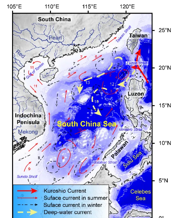
Figure 1.4 Oceanic circulation system in the South China Sea (after Liu et al., 2016). Major currents are noted by numbers: 1. Loop Current, 2. South China Sea branch of Kuroshio, 3. NW Luzon Cyclonic Gyre, 4. NW Luzon Cyclonic Eddy, 5. NW Luzon Coastal Current, 6. South China Sea warm current, 7. Guangdong Coastal Current, 8. South China Sea Southern Cyclonic Gyre, 9. South China Sea Sothern Anticyclonic Gyre, 10. SE Vietnam Offshore Current, 11. Gulf
of Tonkin surface current, 12. Luzon Deep Current, 13. South China Sea Contour Current, 14. Deep Cyclonic Current.
Meanwhile, the intrusion of Kuroshio Current is an important component of the
surface circulation. It is a key process to exchange mass and energy between the South
China Sea and the Pacific Ocean (Qu et al., 2004), and mesoscale eddies originated
from it can transport mass, heat, salt, and sediment in the northern South China Sea
(Zhang et al., 2014). In winter, the Kuroshio Current flows from the northeast of Luzon
to the southwest of Taiwan and then southwestward along the northern slope of the
South China Sea. Because of the topography, the Kuroshio-Island interaction produces
a series of mesoscale anticyclonic eddies between the southwest Taiwan and the
Dongsha islands (Hu et al., 2000; Wang et al., 2003; Yuan et al., 2006). The dominant
path of the South China Sea branch of Kuroshio Current shifts southward and becomes
weak in summer (Yuan et al., 2006). Besides the seasonal changes driven by monsoon,
the cyclonic eddy west to Luzon is active all year around at approximately the same
location, and the Luzon coastal current always flows to the north.
Figure 1.5 Land-sea distribution configurations of the South China Sea with surface circulation patterns during interglacial and glacial periods (after Liu et al., 2016).
(A) Modern/interglacial situation; (B) Glacial situation with a 120-m descending of sea-level.
Looking back in time, the surface circulation may not be always the same as what
we presently observe. On the glacial-interglacial scale, sea-level changes dramatically.
The low sea-level during glacial periods exposes the vast shelves and reduces the basin
surface by approximately half. Most of the straits were closed, water exchanges can
only occur between the South China Sea and the Pacific Ocean through the Luzon Strait.
Assuming that the direction of monsoon winds did not change in glacial periods, a
basin-wide cyclonic (anticyclonic) gyre would form in winter (summer) (Wang et al.,
1995), while the Guangdong coastal current would be driven by the winter (summer)
monsoon to flow southwestward (northeastward) in winter (summer) (Fang et al., 1998).
The time-series variations in the intrusion of Kuroshio Current may not response
directly to this glacial-interglacial cyclicity. Modern observations and numerical
modellings suggest that the intrusion is related to the state of the El Nino Southern
Oscillation (ENSO) (Chiang et al., 2010; Qu et al., 2004; Yang et al., 2014). The Luzon
strait transport can therefore deliver the signal of ENSO to the South China Sea (Qu et
al., 2004).
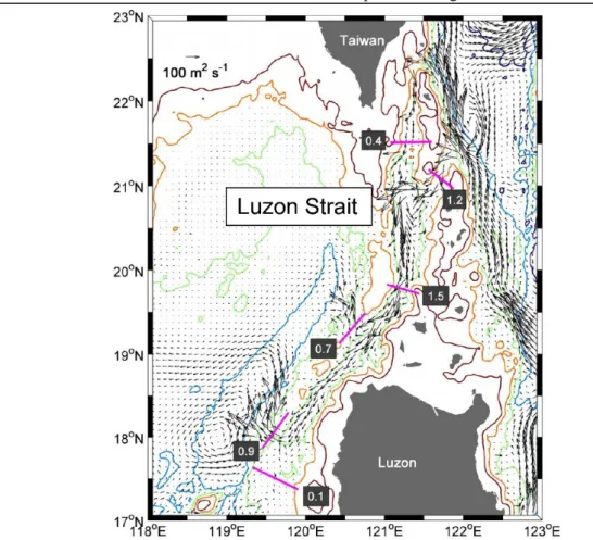
1.4.2 Deepwater current
Differently from the surface circulation that is predominantly driven by the wind
field, the deepwater current is mainly driven by the temperature and salinity gradients
between water masses. The deepwater in the South China Sea, which is usually defined
as the water mass below 1500 m water depth, originates only from the Pacific Ocean
through the Luzon Strait. Hydrological observations at the Luzon Strait and numerical
modelling show that, at present, the deep Pacific water firstly enters the Luzon Strait,
then flows southward along the Luzon Trough, and finally intrudes the South China Sea
through two gaps in the Heng-Chun Ridge (Zhao et al., 2014) (Fig. 1.6). Although the
path of the Pacific water in the deep South China Sea has not been directly observed,
numerical modellings and hydrological investigations shed light on the deep South
China Sea circulation. The density distribution in the sea basin suggests a cyclonic
boundary current system (Qu et al., 2006). Numeric modelling confirms the existence
of such a basin-scale cyclonic circulation, which is related to the salinity gradient and
the deepwater overflow in Luzon Strait (Lan et al., 2013; Wang et al., 2011a). The
in-situ observation by mooring systems and clay mineral distribution in the surface
samples suggest that this deepwater current and the associated mesoscale eddies can
efficiently deliver the suspended particles westward along the northern slope (Liu et al.,
2016; Zhang et al., 2014; Zhao et al., 2015) (Fig. 1.4).
Figure 1.6 Mean volume transport of deepwater at the bottom layer (1900 m to bottom) crossing the Luzon Strait (after Zhao et al., 2014).
The cross sections are illustrated by pink lines with corresponding volume transports noted beside.
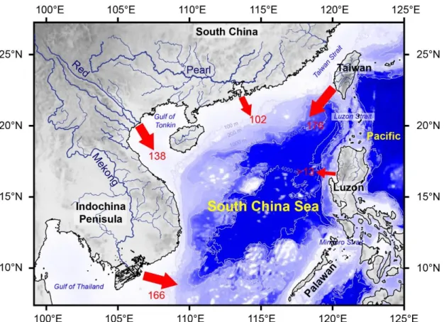
1.5 Fluvial inputs and surface sediments distribution
The highest erosion rate occurs in western tropical Pacific and South China. The
continents and islands in this region represent only 2% of total lands, but they annually
deliver 4.2×10
3Mt of clastics to the ocean, representing 20-25% of the global fluvial
sediment discharge (Milliman and Farnsworth, 2011; Milliman et al., 1999). Acting as
the largest marginal sea, the South China Sea annually receives more than 700 Mt of
terrigenous sediments, and most of them are supplied from the adjacent lands by three
world-class large rivers (i.e., the Mekong River, the Red River, and the Pearl River) and
numerous mountainous rivers on islands (Fig. 1.7) (Liu and Stattegger, 2014).
In general, the fluvial sediment discharge exponentially depends on the drainage
area and the altitude difference. That is the reason that the large rivers present strong
sediment discharges. For instance, the Mekong River, the Red River, and the Pearl River
annually delivers 160 Mt, 130 Mt, and 84 Mt of sediments, respectively, into the South
China Sea (Milliman and Farnsworth, 2011; Milliman and Syvitski, 1992; Zhang et al.,
2012). However, the sediments from the Mekong River and the Red River can barely
reach the northern part of the South China Sea due to the well-developed deltas and the
topography of the Gulf of Tonkin. The Pearl River is therefore the only major river that
supplies the northern South China Sea.
Figure 1.7 Fluvial drainage systems and their annual sediment discharge to the northern South China Sea (after Liu et al., 2016).
Taiwan is an island of 36000 km
2with the highest altitude of over 3000 m at the
central ridge. It is the most important source of terrigenous clastics for the northern
South China Sea, annually supplying 176 Mt of sediments (Dadson et al., 2003; Huh et
al., 2009; Liu et al., 2006; Milliman and Farnsworth, 2011). Although the drainage areas
of rivers in Taiwan are much less than that of the Pearl River, several factors, including
the steep topography, the active tectonic, and the frequent catastrophic typhoon/storm
events, largely increase the river denudation in Taiwan. For instance, the cyclone-driven
floods have been observed to deliver huge amounts of clastic sediments to the abyssal
basin of the South China Sea (Hilton et al., 2008; Liu et al., 2012a), and
seismic-triggered landslides can sharply enhance the fluvial sediment evacuation (Hovius et al.,
2011; Meunier et al., 2008).
Luzon is also located on the Pacific Rim of Fire with active volcanic activity. Its
fluvial drainage system is well-developed. The biggest river, the Cagayan River, drains
the northern part of Luzon and finally flows into the Luzon Strait. The second biggest
river, the Pampanga River, flows through the southern part of Luzon to the Manila Bay.
Numerous small rivers that supply the South China Sea are distributed in the western
part of Luzon. Based on the available sediment load data, the total sediment discharge
of Luzon to the South China Sea is estimated to be 42 Mt/yr at present (Liu and
Stattegger, 2014).
These terrigenous sediments compose approximately 80% of the total deposits in
the northern part of the South China Sea while the rest 20% is biogenic carbonates and
silicates (Wang and Li, 2009). Their distribution in the surface sediments is closely
related to water depth and topography. In general, the shallow shelf deposits mainly
consist of terrigenous clays and silts with minor bioclasts, the deposits on slope are
composed of both biogenic (carbonates and silicates) and terrigenous clastics, and the
abyssal deposits are mainly terrigenous clays with biogenic silicates (Wang and Li,
2009).
Chapter 2
Material and Methods
In order to reach the goals of this study as described in the “General Introduction”,
the sediment core MD12-3432, retrieved from the northern South China Sea, is
analyzed. Clay mineralogy, magnetic properties, major element compositions, and
grain sizes are investigated. In the present chapter, the sediment core and the analytical
methods adopted to achieve the objectives will be presented in details.
2.1 Material
The 50.8 m long Calypso core MD12-3432 (19°16.88’ N, 116°14.52’ E, water
depth 2125 m) was retrieved in 2012 on board the R.V. Marion Dufresne during the
French-Chinese CIRCEA cruise organized within the co-laboratory frame “Laboratoire
International Associé - MONsoon, Ocean and Climate” (LIA-MONOCL). It is located
on the East slope of a giant canyon, which is supposed to be paleo-Pearl River canyon,
in the northern South China Sea. Sediment of core MD12-3432 is homogenously
dominated by gray clays with several intervals rich in foraminifera and organic matter
(Kissel et al., 2012). No turbiditic layer is observed in the sediment sequence of core
MD12-3432.
Figure 2.1 Map of the northern South China Sea. The location of core MD12-3432 illustrated by the yellow star.