Contested Valleys
Reclaiming the Common Landscape in Bisri, Lebanon by
Joude Mabsout
Bachelor of Landscape Architecture American University of Beirut, 2016
Submitted to the Department of Architecture
in Partial Fulfillment of the Requirements for the Degree of Master of Science in Architecture Studies
at the
Massachusetts Institute of Technology May 2020
© 2020 Joude Mabsout. All rights reserved
The author hereby grants to MIT permission to reproduce and to distribute publicly paper and electronic copies of this thesis document in whole or in part in any medium now known or hereafter created.
Signature of Author: ____________________________________________________________________ Department of Architecture May 8, 2020 Certified by: __________________________________________________________________________
Rafi Segal, PhD Associate Professor of Architecture and Urbanism Thesis Supervisor Accepted by: __________________________________________________________________________ Leslie K. Norford Professor of Building Technology Chair, Department Committee on Graduate Students
Thesis Supervisor
Rafi Segal, PhD
Associate Professor of Architecture and Urbanism
and readers
Rania Ghosn, DDes
Associate Professor of Architecture and Urbanism
Miho Mazereeuw, MArch, MLA
Contested Valleys
Reclaiming the Common Landscape in Bisri, Lebanon by
Joude Mabsout
Submitted to the Department of Architecture on May 8, 2020
in Partial Fulfillment of the Requirements for the Degree of Master of Science in Architecture and Urbanism ABSTRACT
Failed infrastructure initiatives have been at the forefront of Lebanon’s 2019 October Revolution, a nationwide movement born from the frustrations of unjust laws and misuses of public funds. The uprising has put the government’s corrupt plans in the spotlight, one of which is a national strategy of dam construction spanning the entirety of the country. This thesis re-examines how large-scale water infrastructure in Lebanon has disrupted ecologies and uprooted local communities, exacerbating existing social tensions for political gain. Visualizing river valleys as contested landscapes, this thesis explores the transition of these valleys from a constant state of destruction to places where people can reclaim their rights to the landscape.
Taking the case of the Bisri Valley, where a highly contested Dam mega-project is in the process of being built, this thesis proposes an alternative future for the valley, transforming it from a politically contested dam reservoir, to an environmentally and socio-culturally preserved collective landscape. Through sectional studies, design strategies are proposed as a way to both protest the continuous threat on the landscape and offer a toolkit for action. This toolkit presents a set of interventions that allow for the activation and preservation of existing landscape ecologies and communities, amounting to a constant act of reclaiming and protecting the land. This project reimagines the landscape as a new hima, a locally rooted meaning for the commons. The proposed design operations aim to act as a prototype for
collective actions of preservation and engagement, re-anchoring people with their landscape in the face of divisive projects.
Thesis Advisor: Rafi Segal
Joude Mabsout Thesis 2020
MIT SMArchS Urbanism
Contested
Valleys
Reclaiming the common landscape in Bisri, Lebanon
Acknowledgements
I would like express my gratitude to my advisor, Rafi Segal, for the guidance, insightful weekly discussions and support throughout the process. I would also like to thank my readers, Rania Ghosn and Miho Mazereeuw for their support, bringing in new perspectives and for their fruitful feedback. I am also very grateful for the close circle of friends I am surrounded by at MIT and my classmates in the SMArchS Urbanism program. Melissa, Moon, Mengfu, Melika and Daniella for making this journey a full and fun one.
I am extremely grateful for my family’s constant support from Lebanon and for their belief in me. My mother, for our inspiring talks and for accompanying me on my site visits. My father, for his constant support and for always pushing me forward. My sister, for supporting and inspiring me.
Meeting activists and local residents in Bisri has kept me hopeful. I am thankful for the interviews with Roland Nassour, from the “Bisri Campaign”, and all experts I learned immensely from.
I am thankful for Mayssa’s support and helpful feedback. Ahmad, for investigating with me during site visits.
I will always be grateful for the support from my Cambridge friends and family, and for the lightness they have brought during the challenging times; Nadia, Omar, Ranan and Ramzi. Finally, I would like to thank Ramzi, for thinking with me, supporting me and for always being there.
Table of Content
00 Introduction 7-13
01 Politics of Water Infrastructure in Lebanon 14-21
02 Cases of Contestation 22-30
03 Transitioning to a Landscape Common 31-51
04 Collective Operations 52-68
05 Conclusion 69
00 Bibliography 70-71
00
Introduction
On November 16, 2019, a dozen tents were set up in the pineforest of the Bisri Valley. A group of civilians gathered to form a “sit-in” overnight in the contested landscape of the river valley. The banner “Save the Bisri Valley” was hung between the trees, and had been carried by protesters since February 2019, when the construction of the Bisri Dam began. The actors countering the project ranged from civilian activists, environmentalists, scientists, to other politicians. They took different modes of action and one of the predominant ones was protesting on the
ground by mobilizing groups to hike through the pine forest in the valley, camping overnight and forming spaces for discussion, where experts gave public lectures that shed light on the negative repercussions of building the dam. The 2019 Lebanese revolution is the result of an accumulated frustration among citizens who live with the consequences of a corrupt political elite. Of them, is an inadequate infrastructure system, which has worsened urban and environmental conditions rather than ameliorate the living conditions of people. Today, there is a long-term national strategy for the creation of dams spanning the entirety of the country. While the implemented dams were planned
in the name of economic growth and prosperity, they fell short of their stated objectives, causing destruction and displacement instead. As such, these projects symbolize a trend of continuous environmental deterioration, becoming one of the main reasons driving Lebanese protesters to the streets, as they reclaimed their right to landscape.
In Lebanon, infrastructure has been used to fragment the landscape and detach people from their land, in order to benefit sectarian political factions. As a consequence,
ecosystems have been interrupted, through the exploitation of natural resources and the uprooting of local communities. This has exacerbated social divides, as landscape is now used as a tool to gain power, giving each patch a particular political identity. Since the revolution emerged, the Bisri dam has been at the forefront of such projects. First proposed in 1953, the Lebanese Council for Development and Reconstruction (CDR), in collaboration with the World Bank, re-launched it in 2014, as a supposed solution to Greater Beirut’s water needs. The plan was met with skepticism by the general public and activists as revelations of a large number of negative repercussions intensified.
This thesis argues that the Bisri Dam is not solely an infrastructural project, but also a political
maneuver to entrench existing powers and exacerbate societal rifts. By exploring politics of water infrastructure in Lebanon, this thesis draws on how water evolved over time from being a shared resource among citizens, into a privatized tool within political sects. I specifically look at the relationship between corrupt dam infrastructure projects and river valleys, studying the tension between the concrete mega-projects represented by political groups and the hybrid landscapes represented by the landscape itself, activists and local citizens. The process of endless ecological and cultural destruction paralleled with a continuous state of protest, can be seen as a two sided fight with the landscape in between; a battle for different worlds of the landscape.
The Bisri project is not an anomaly to the trend of infrastructure projects that erase the landscape at a territorial scale. Since the end of the Civil War in the 1990s and with emergence of neoliberal politics, Lebanon witnessed a fast trend in privatized and polluted landscapes across the territory (Makhzoumi, 2011). Privatized coastlines, erasure of cultural heritage, a polluted Mediterranean
Sea, garbage crises, quarried mountains, and dammed rivers; this image, almost a dystopian landscape mosaic, draws on how corruption and sectarianism manifests spatially. The political structure of post-war Lebanon is an extension of the structure during the war, where war militias turned into religious-political organizations, which exacerbated Lebanon’s neoliberal policies (Abou Akar, 2018).
The political decisions being made have direct implications on the natural environment and socio-cultural landscapes, which begs the question of how urbanists and designers can contribute to fight for ‘the right to landscape’. Shifting the narrative from a political one to an environmental and socio-cultural one becomes crucial in order to use landscape and other spatial tools to create resilient spaces for protection. Within these contested landscape territories, this thesis focuses on the ‘couple’ of dam infrastructure and river valleys as a case of contestation.
Protest
top right image
Protest in Lebanon 2019 Revolution, Image Source; Walid El Khoury, Open Democracy
Infrastructure Crisis
bottom right image
Article from The New York Times, 2019
Contested Valleys
Introduction Introduction
Dam Construction in Lebanon
Source: Google Earth and Photography by author
Balaa Dam
Qaysamani Dam
Chabrouh Dam Jannah Dam
Moving from a purely
political dispute
over territory, to a
socio-environmental
narrative,
how can landscape
be used as a tool to
reclaim itself?
Valley Profile right image Photograph: by author Contested Valleys Introduction Introduction 10The mountains, river valleys, the coast and the Mediterranean Sea represent a linear landscape sequence of the Lebanese territory. As the river systems drain Mount Lebanon into the sea as part of their hydrological lifelines, they recharge the aquifers. Dating back to the fifteenth century, the rivers took a socioeconomic role, where watermills enabled the processing of grains into flour, which became commercial hubs. In the mid-twentieth century, the rivers became borders acting as physical limits to administrative boundaries (Frem 2017).
The current condition of these river valleys has been transforming from an unwanted landscape to being coveted for extraction processes and urban water needs. Visualizing river valleys as contested
landscapes, this thesis explores the transition of these valleys from a constant state of destruction to places where people can reclaim their rights to the landscape. Taking the case of the Bisri Valley, where a highly contested Dam mega-project is in the process of being built, this thesis proposes an alternative future for the valley, transforming it from a politically contested dam reservoir, to an environmentally and socio-culturally preserved collective landscape.
“Landscape, not as an object to be seen or a text to be read, but as a process by which social and subjective identities are formed”
(Mitchell, 2002).
Chapter 4 brings us to the Collective Design Operations, where a toolkit presents a set of interventions that allow for the activation and preservation of existing landscape ecologies and communities, amounting to a constant act of reclaiming and protecting the land.
Finally, this project reimagines the landscape as a new hima, a locally rooted meaning for the commons. The proposed design operations aim to act as a prototype for collective actions of preservation and engagement, re-anchoring people with their landscape in the face of divisive projects.
In Chapter 1, I focus on how the evolution of water politics led to the loss of public water rights, also leading to infrastructure planning that is detached from environmental systems. This resulted in contested valleys, where I focus on in Chapter 2. River valleys across the country are threatened by loss of natural habitat and the erasure of cultural landscapes. I focus on three Dam cases within contested valleys that are at different phases of construction (implemented, in process of construction, and in process of protest).
After zooming into the process of protesting the Bisri Dam, I move on to Chapter 3, where I propose an alternative vision for the valley, a process of reclaiming, protecting and collectively sustaining the landscape. Through sectional studies, design strategies are proposed as a way to both protest the continuous threat on the landscape and offer a toolkit for action.
This thesis borrows W.J.T. Mitchell’s idea in Landscape and Power, where he proposes to “change ‘landscape; from a noun to a verb”. Here, landscape becomes a medium to form and anchor socio-cultural identities.
Nature Preserve/Dam Reservoir
right image
Juxtaposing signs at the entrance of the Bisri Dam project. Green sign says “Welcome to the Bisri Preserve”, set up by activists. Yellow sign is the Bisri Dam Project information sign.
Protesting the Bisri Dam Source: ejatlas.org
Dam projects symbolize
a trend of continuous
environmental
deterioration, becoming
one of the main reasons
driving Lebanese
protesters to the streets,
as they reclaimed their
right to landscape.
Contested Valleys
Introduction Introduction
Protesting the Bisri Dam
by re-occupying the
01
Politics of Water Infrastructure
The first water laws in Lebanon date back to the Ottoman Empire(1516-1917), and were later amended during the French Mandate (1920-1943), and after the emergence of the Republic of Lebanon (1943-present). The evolution of water legal framework from the 16th century until now depicts a trend of water access moving from groundwater supply to surface water collection. The process of shifting from groundwater to above ground was affected by three main factors; the change in political structure, mismanagement of well drilling, and aquifer depletion. The shift from Levantine customs to modern legal framework was paralleled with an incremental damage of the environment. Current water laws in Lebanon are outdated, since the “laws governing water use in Lebanon are based on practices and rules that evolved according to historical land regimes, directly related to political power in specific historical moments” (Riachi, 2016). Under the Shariaa Rule in the Pre-Tanzimat (1516-1839), the Sunni Hanafi School recognized that God owns water but there were two water entitlements: the Mubah (sovereign waters of sea, rivers, etc...) and the Mulk (private canals, wells). The idea of privatized water possession was passed on within family fiefs. Mount-Lebanon was among the
Evolution of Water Infrastructure in Lebanon
first regions in the Ottoman Empire that had an early development of private land property. A prominent family in Mt. Lebanon, the Jumblatt family, is currently still in power and possession of water springs and preserved areas. During the Tanzimat period (1839-1877), the 1858 Defter Khane and 1877 Medjelle were two rules of water reform that allowed for more privatization rights over water, which increased the amount of wells that were drilled across the territory.
The ownership of water moved from a God, or a Sultan ownership type to a Public-Private framework during the French Mandate and national construction. Modern laws and deeper wells emerged, and a new hydraulic paradigm was introduced. in the 1950s, the influence of the USBR (US Bureau of Reclamation), through one of its funds from the World Bank led a mission to build dams, influenced by the (TVA) Tennessee Valley Authority. The first dam, the Qaraoun dam was constructed in the Bekaa Valley.
The post-civil war period (1990s) brought back projects that were on hold, such as the dams. The pace of dam construction was slow, and accelerated in 2013 after international loans were accepted for the Lebanese Government.
Contested Valleys Politics of Water Infrastructure
Beqaa BML "Abstract of law in Lebanon at the time of Emirs Chehab" Defter Khane Land Registration Collective Agriculture Lands (Mushaa’ Lands)
Medjelle Code of Irrigation Water Laws Foreign
Influence Decree 11438 CDR MoE
regulate agricultural water use. It regulates irrigation use on shared irrigation schemes, defines sanctions and responsibilities of individuals and the administration of irrigation network maintenance. Its provisions remain relevant and govern the current irrigation management
1) land registration and the privatization of the collective land under mushaa
2) the establishment of Water laws
3) the introduction of a hydraulic engineering paradigm Boom in private irrigation USBR and LRA private property and access to
natural resources recognition of water private rights
public waters: lakes, seas, groundwater and large rivers first privatization wave of collective mushaa lands usufruct rights water sharing, rotational water distribution and maintenance requirements 1733 1800s 1858 purchasing water springs in Mount Lebanon Iqtaa system administrative organization of fiefs, assigning territory control to feudal families to collect taxes from an area or community. Farmers are allowed to use land in exchange for loyalty to the muqtaajis and for paying taxes to the Sublime Porte.
Based on customs and the Hanafite
jurisprudence but also drawing on the Napoleonic code, the Medjelle established a complementarity between Muslim laws and the Roman law, at least with regard to private property and access to natural resources. sharpened social inequalities between those who benefited from land reforms and poorer commoners (aamma), instituting uneven access to private property and fueling farmers revolts all along this period.
Pre-Tanzimat God Ownership W ater Legal F ramework Period
Sultan Public and Private Public and Private
1516-1917 Ottoman Empire
groundwater based supply and irrigation Modern lawsdeeper wells Sectarian Division
1516-1839 Tanzimat Reforms 1839-1877 French Mandate 1920-1943 Republic of Lebanon 1943-Present 1877 1913 1920-1943 1950s-60s Exploitation and use of groundwater Wave of reforms to reorganize public water institutions and set up a physical strategic vision (10 year plan) -complete neglect of groundwater management as being part of Water Authorities’ responsibilitie s. It rather focused on technical and financial aspects of Council for Developm ent and Reconstru ction establishe d Ministry of Env. Establishe d National Physical Masterplan 1970 1977 1993 1975 1990 MoEW NPMLT 2000 2009 National Water Strategy NWSS 2012 privatization and dam building Blue Gold Plan 2014 Parliament has ratified a new code that allows the private sector to build and run public water utilities. Water Code Law 77 2018 Law 221 civil war Timeline of Water Legal Framework
Trend in water privatization and the emergence of dam infrastructure Diagram: by author,
groundwater mismanagement private wells
aquifer depletion privatized groundwater
privatized surface water
dams and surface water collection
Dams lead to the destruction of cultural and environmental landscapes, often wiping out symbols of a common identity, further reinforcing societal division. Confessionalism and clientelism leads to lack of
reliable water infrastructure, pushing people towards private wells.
1
3
Underperforming dams, polluted rivers and lack of adequate water supply
infrastructure maintains the dependence on private wells.
4
This encourages the government to search for alternative water resources.
2 Coast/Urban
Valley/Rural
Private Water, Above and Under
The linear evolution of acquiring water from groundwater sources, coupled with usufruct rights to groundwater (one can own and dig up a well outside their property), into a supply-side vision focusing on dam building, has obstructed the chance of having public-policies regarding the public rights of water and groundwater conservation. Water has been privatized under and above ground as the large water projects in the Lebanese context are influenced by territorial and political power issues
overlapping with different basins. The Awali River, the river that passes through the Bisri Valley, is a boundary between the Chouf and Jezzine Districts, making the Bisri project a highly contested one. The right to water, whether it is the right to acquire water as an urban dweller, or in a rural setting, groundwater mismanagement, and the lack of attention to rework the existing water infrastructure in the urban settings, coupled with the dependence on river valleys for maintained by the confessional
system. Confessionalism, a unique political regime for Lebanon where the government is formed by a grand coalition consensus among different politicians, proportionally allocating political power among the country’s community sectarian lines (Riachi, 2016). Dams become projects for land grab and territorial expansion, where at least every single political party has one dam project on its agenda. Also, the geographical boundaries of Cazas/districts are along rivers,
bringing water to cities, leads to a loss of the right to landscape at a territorial scale. While aquifers are depleted and polluted, there is not enough action among politicians to distribute even access to water, as they continue to profit from large-scale water investments and targeting international
organization’s development loans to their electoral constituencies. As a result, not only is the aquifer being depleted, but valleys and mountains are being destructed. Water Infrastructure Loop
Diagram: by author,
Contested Valleys
Politics of Water Infrastructure Politics of Water Infrastructure
CDR BISRI DAM Project Management Team NGOs CBOs Supervising Consultant Contractor E&S
Panel SafetyDam
GBA
Municipalities Dam SafetyPanel PanelE&S EDL LRA BMLWE MoE Funding Agency
MoF MoA MoC MoEW MoE MPWH MoIM Government Concerned Ministries
Other Ministries
There are three scales for water management in Lebanon, at the national scale, the Ministry of Energy and Water is the main entity involved with water infrastructure projects, along with the CDR (Center for Construction and Redevelopment), which is a main governmental body responsible for tendering and managing large-scale investment projects. The Ministry of Environment has involvement to assess the implications of the infrastructure projects. CDR was created in 1977 and replaced
The stakeholders concerned with the Bisri Dam project, as shown in the chart above, have different responsibilities intervening at different stages of the project. As the project aims to bring water form the South of Lebanon towards Beirut, the involvement of the municipalities within the valley are only being considered during the land expropriation process, and not in the management of the dam, which removes the possibility of allowing- if the dam were to be built- the local residents to benefit the Ministry of Planning to boost
reconstruction efforts after the Civil War. In the regional 4 water establishments, the Mohafez (governor- there are 8 Mohafazas) and Qaimaqam (prefect of a Caza- there are 25 Cazas) approve public work plans of municipalities. The LRA (Litani River Authority) is an establishment for the Litani River watershed. At the local level, municipalities are responsible for public works, and may have begun to merge to form joint water networks.
from the projected water collection. The main groups being questioned by activists and people opposing the project are the Center of Construction and Redevelopment (CDR), the funding agency (World Bank) and the Ministry of Energy and Water. At the local level,
municipalities within the Bisri Valley have condemned the project from happening.
Current Water Sector Actors Institutional Structure for the Bisri Dam Management
AKKAR NORTH LEBANON BAALBECK MOUNT LEBANON BEIRUT Beirut BEIRUT El Matn Baabda Aley El Chouf Jezzine Litani River Lake Qaraoun Lake Markaba Bisri Dam Lake Joun To GBML Residents Awali River Wardanieh Water Treatment Plant 60-100 MCM* 5-17 MCM* 14-41 MCM* 50 MCM** Jezzine Spring Ain Zarka Spring
* Dependin on the year, whether it is a wet or dry year ** As per the Decree No 14522 May 16, 1970 on the allocation of water resources of the Litani River and other sources of water
Lake Qaraoun Pollution Prevention Project Sewerage networks and wastewater treatment plants
BEKAA SOUTH LEBANON MOUNT LEBANON Beit Meri Beirut Wadi Rishmayy a Nahr El Aouali Sayniq Damour Wadi as Sitt Baruk Litani Al Hadath Baabda 33°40°N 33°50°N 35°20°E 35°30°E 35°20°E 5 Miles 0 0 5 10 Kilometer 35°30°E 35°40°E 33°30°N 33°40°N 33°30°N Saida Zahrani Aley Choueifat Beiteddine Baakline Jieh Barja Shhim Mazboud Bisri
Proposed Bisri Dam and Reservoir Karaoun Lake Anane Reservoir Awali Pond
Existing Boulos Arquash/ Awali Hydro Power Plant Bisri Hydro
Power Plant Joun Reservoir
Existing Ibrahim Abd El Al/ Markaba Hydro Power Plant Markaba Reservoir
Existing 26km
Existing Joun Tunnel
Di version T
unnel
Joun Adit and Regulation Structure Ouardaniye Water
Treatment Works
Tunnel Inlet/ Outlet Portals
Damour Ventilation Shaft Damour Ventilation Shaft
Khalde Surge Shaft Khalde Tunnel Portal
Khalde Flow Measurement and Sampling Chamber Hazmieh Reservoir
Khalde Connection Chamber to Tallet El Khayat; Khalde Distribution Chamber
Damour Washout Jezzine Mashgharah Karaoun Joun Deir el Qamar Damour Khalde Area of map BEQAA NABATIEH SOUTH LEBANON
Understanding the history of the Bisri Dam is crucial in order to contextualize the project based on time, but also investigate the multi-scalar actors that contribute to the political framing
The Bisri Dam was initially proposed in 1953 by the U.S. Bureau of Reclamation (USBR) as part of a series of river basin development plans for developing areas in the latter half of the twentieth century. During that time, The Tennessee Valley Authority TVA introduced the idea of “modern” river development. While it claimed to promote economic growth and ‘grass roots’ democracy, a number of people critiqued the fact that TVA officials and local power brokers monopolized many areas of the valley. TVA-style basin development constituted an important part of foreign policy objectives from the 1950s into the 1970s.
While the Bisri Dam had not materialized since then, the proposal re-emerged in the early 2000s, by the Council for Development and Reconstruction (CDR), a governmental organization in Lebanon established in 1977 during the Civil War with the aim to assess infrastructural needs and allocate international and Lebanese aid for rebuilding the country. The Bisri Dam began to materialize
The Bisri Dam and Greater Beirut Water Supply Project
after the World Bank approved the funding in September 2014. The Bisri Dam is part of the World Bank Greater Beirut Water Supply Project (GBWSP), which aims to tackle water scarcity for people living in Greater Beirut Area (GBA), due to the “limited water resources, infrastructure deficit and suboptimal water resources management”, the large-scale project encompasses the construction of a dam, reservoirs and water conveyors, and is expected to bring potable water from the Litani river, a toxic and polluted river that would meet the reservoir of the Bisri Dam, to over 1.6 million residents of GBA.
GBWSP Project
right image
Map and Strategy of the Bisri Dam proposal.
Image reworked by author from the World Bank
Contested Valleys
Politics of Water Infrastructure Politics of Water Infrastructure
With the sectarian distribution of governmental posts, the ministries involved with the dams can be directly linked to specific political parties that have a variety of motives, other than using the dam as a water source for citizens.
First, the dam represents political ambition. The main ministries
involved, the ministry of Energy and Water, Environment, and Foreign Affairs are all headed by one political party, the Free Patriotic Movement (FPM). The Bisri Dam is also located at the border between two districts with a violent history involving this political party. The FPM leader has presidential aspirations, uses these mega-projects to portray the image of a strong leader. Through the overlap of these relationships and the geographic location, we can see how the dam advances a narrow political agenda.
Second, the Dam maintains the ghost of the civil war in people’s minds. The head of the Council of
Development and Reconstruction (CDR) is under another political party, the Future Movement. Since its creation, the CDR remained under the control of this party and was supposed to be temporary but remained active as an almost autonomous powerful entity to bring in large funds and implement large projects.
Third, it becomes justification for further authoritarian acts.
The site has become a frontier to the citizens as the Internal Security Forces (ISF) was sent by the Ministry of Interior and Municipalities, also represented by the Future Movement, in order to guard the newly opened construction site. Authoritarian control emerged in the physical space but also through online surveillance. Freedom of
expression was also threatened as people were interrogated for voicing out their claims of opposition.
Fourth: This dam has a rippling effect that creates economic benefits for the political elites.
For example, one of the members of the FM movement bought a piece of land with cultural value at the mouth of the river along the coast, further privatizing the river downstream (Jabri, 2020).
These four political motives reveal the intangible consequences of the dam.
Bisri Dam as a Political Maneuver
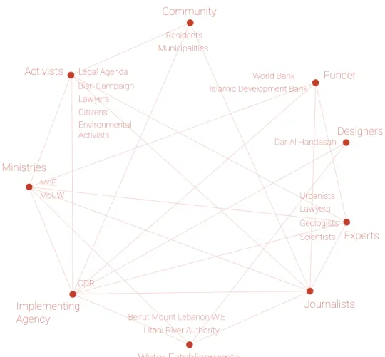
Actors of the Bisri Project
Mapping communication between promoters and activists.
Diagram by author Ministries Implementing Agency Journalists Water Establishments Activists Community Funder Experts Designers
Beirut Mount Lebanon W.E Litani River Authority CDR Bisri Campaign Legal Agenda Residents Municipalities Urbanists Dar Al Handasah World Bank
Islamic Development Bank
Lawyers Geologists Scientists Lawyers Citizens Environmental Activists MoE MoEW
The relationship between geography and law is missing in Lebanon, where 85% of Lebanese Territory remains unplanned (Public Works, 2018). With the lack of planning, large projects and strategies become implemented in a non-contextual manner, where infrastructure is now devoid of socio-cultural and environmental considerations.
Lebanon has a large water storage capacity, encompassing around 50 phreatic zones. Water Authorities have not yet planned for the conservation and the management of aquifers. Instead, their focus is on restructuring the administration to host PPS (Public-Private-Partnerships) and building dams. The reliance on massive infrastructure that is centralized politically and physically, instead of decentralized networks that are more integrated within local ecologies and communities, is leading to massive erasure of landscapes.
From a geological perspective, two thirds of Lebanon’s landscape is karstic, characterized as permeable limestone rock. The dams end up losing water instead of retaining it. For instance, the Chabrouh dam loses about 200 liters per second (Riachi 2016). Similarly, the Janneh dam that is currently being built on the Ibrahim River, scientific studies
Infrastructure Independent of Environmental Systems
show that there is a 50% chance to retain the water needed. The Bisri Dam is faced with this same conflict, and is also on a seismically active zone (Nemer, 2019). With this reality, the construction of the dam will need an impermeable cement base, which will triple the cost of the project and also need the ‘cementation’ of an entire valley.
Janneh Dam under construction. Photograph: by author
Bisri Valley
Image Source: Save Bisri Valley The National Physical Masterplan of the Lebanese Territory (NPMLT), commissioned by CDR and
endorsed by the government in 2012, has identified the river valleys, as important landscape areas to be preserved, where the Bisri Valley is considered to be part of the national park. This contradicts the National Water Sector Strategy
(NWSS) which was later proposed 22 dams on the Lebanon’s 17 perennial rivers.
The gap between this territorial masterplan and infrastructure projects is due to the lack of planning at the medium scale of districts.
The current dam infrastructure being proposed is a mono-functional design that is not adaptable to the shifting climate. Reservoir filling rates around the
world have decreased due to global warming and climate change. The Bisri dam is projected to collect 125 MCM/year, by the World Bank, which opposes the average yearly flow of 80 MCM (Allaw, 2020). The Litani River Authority (LRA) estimated that groundwater storage decreases annually by 70 million m3 (Amacha 2014). With the decrease of rainwater as well, dam infrastructure is questionable for relying for water collection. Finally, ‘soft’ infrastructure is needed that is adaptable to hydrological and ecological systems within the landscape, as well as rearranging existing networks instead of implementing destructive massive infrastructure is needed to sustain resilient landscapes.
Contested Valleys
Politics of Water Infrastructure Politics of Water Infrastructure
Landscape sequences across the territory
Map by author, compiled from NPMLT, 2009
Planned Dams across the territory
Map by author, compiled from NWSS, 2012
02
Cases of Contestation
The planning of dams perpetuate existing inequalities and maintainthe dominance of the political elite over the landscape. Lebanon’s landscape is highly contested as large infrastructural projects are carving out the natural terrain of its river valleys, destroying socio-cultural spaces and agrisocio-cultural practices that are embedded within these geographies. The process of dam construction is a bordering practice, which further fragments the landscape and communities in the country. The displacement of people, erasure of cultural heritage and environmental assets weakens the aim of preserving a common landscape identity that defies the existing sectarian identity. Dam construction was met with doubt among citizens and environmental activists, especially since a
number of built dams have failed in Lebanon. For example, the Qaraoun dam went through its driest time in the Winter of 2013-2014 and its reservoir has only filled 40 mm3 out of the 220 mm3 potential. Another example is the Chabrouh Dam completed in 2007, which showed only 1% of its original aim in the 1999 Decennial Plan (Riachi, 2016). The Brissa Dam, completed in 2013 has never been able to fill up due to the Karst landscape. The Janna Dam, currently being constructed is projected to leak, similarly to what is being projected for the Bisri Dam. (BGR 2012).
Dams and Contested Valleys
In this chapter, I will focus on three contested valleys, each threatened by a Dam project at different construction phases: Mseilha Dam (completed in 2020), Janna Dam (under construction), and Bisri Dam (being protested). These dams are part of the National Water Sector Strategy (NWSS), a supply-side vision for water collection dam building across all the rivers in Lebanon. The NWSS is in contradiction with the National Physical Masterplan for the Lebanese Territory (NPMLT, 2009) since the proposed ‘blue-green’ network, a natural space continuity across the territory, encompasses the protection of the mountain peaks (Lebanon’s water tower), rivers, and valleys. All of the proposed dams are juxtaposed with the proposed natural parks and preserved river valleys. The dams under construction are faced with local disapproval, municipalities, citizens across the nation and NGOs. While the Mseilha and Janna Dam were implemented without an environmental and social impact assessment (ESIA), the Bisri Dam, since it is under the World Bank which requires certain guidelines to follow, has had an ESIA. Even with the ESIA being done for the Bisri Dam, the impact of the dam on the valley shows a massive loss of local ecologies and regional ecosystems.
Contested Valleys Cases of Contestation
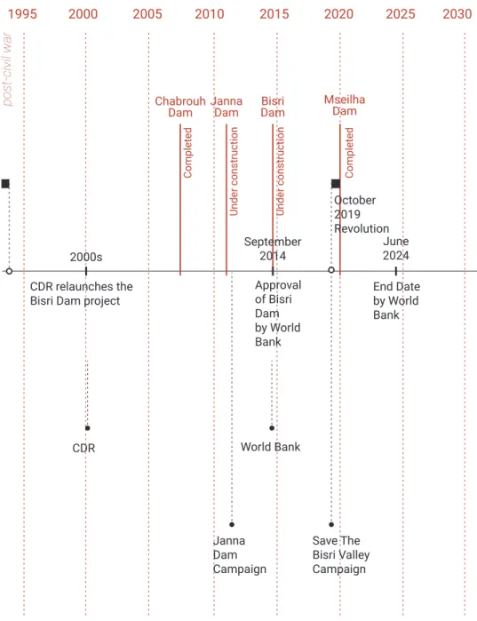
The Bisri Dam was initially proposed in 1953 by the U.S. Bureau of Reclamation USBR Litani Dam BISRI DAM TIMELINE
CDR Established Civil War Completed USBR TVA TVA USBR 1953 1977 1960 1955 1965 1950 1970 1975 1980 1985 Bisri
Dam MseilhaDam Janna
Dam Chabrouh
Dam
CDR relaunches the
Bisri Dam project Approval of Bisri
Dam by World Bank October 2019 Revolution End Date by World Bank Completed Completed Under construction Under construction CDR World Bank Save The Bisri Valley Campaign Janna Dam Campaign 2000s September2014 June2024 1995 2000 2005 2010 2015 2020 2025 2030
History of Dams and Actors
pre-civil war Diagram by author
Emergence of Dam Construction
post-civil war Diagram by author
Three Dam projects are investigated and documented in Lebanon. The Mseilha Dam, just completed and located in the North, the Janna Dam which is under construction, and the Bisri Dam, in the South of Lebanon, currently on hold as protesters and activists are calling for it to be halted. The cases were chosen to show a variety of geographic locations, completion status and function. The three dams are catering for urban cities, addressing the water crisis in Lebanon. While the territory is abundant with water, the mismanagement of water infrastructure has led to the targeting of river valleys. These three dam projects also have a common political party being the chief proponent of them, the Future Patriotic Movement (FPM). This investigation series transcends from a territorial mapping of three dams, representing one mega-dam project led by one political sect, to site documentation of the impact of these dams on each river valley.
22km
THREE CASES OF CONTESTED VALLEYS
01 02 03 02 Janna Dam 03 Bisri Dam 01 Mseilha Dam Contested Valleys
Cases of Contestation Cases of Contestation
Lake Mseilha Dam is located on Nahr El-Jawz, upstream of the historical castle of Mseilha in the Caza of Batroun, east of the new Batroun - Chekka road. The objective of this dam is the creation of a reservoir capable of ensuring drinking water of a portion of the localities in the Cazas of Batroun and Koura up to 2030, water supply to certain industries in the region as well as irrigation of agricultural lands located mostly at North of Nahr El-Jawz with 1000 hectares (ha) of exploitable area.The construction of the dam finished in late 2019 after years of implementation problems. Experts confirm that “Mseilha Dam suffers from a fundamental flaw, namely its proximity to the estuary”. This will lead to the buildup of large amounts of sediment and sludge behind the dam and impair the flow of the water, necessitating the use of costly pumps.
photograph by author NAME Mseilha Dam LOCATION Nahr El Jawz SIZE MCM 6m3 CONDITION Completed USE Potable water for Batroun and irrigation supply TIMELINE 2014 Construction starts 2020 Water gathering begins. Fails to meet expectations.
Janna village is located upstream of the Ibrahim River, which runs beneath snowcapped peaks to the Mediterranean Sea, The river passes through the cultural landscape of the Adonis Valley, which is lined with waterfalls and natural springs and home to some 700 animal and plant species.
Blocking the river by the dam will require flattening up to 500 acres of hillside forest, and will not only stifle the river flow and destroy natural habitats but endanger a vast underground network of aquifers that feed Beirut’s primary water source, the Jeita spring. The spring, 20 miles southwest of Jannah, produces a subterranean river that courses through the Jeita caverns, a major tourist attraction and a symbol of national pride seen on postcards and currency notes (Battah, 2016). photograph by author NAME Janna Dam LOCATION Nahr Ibrahim SIZE MCM 30m3 CONDITION Under Construction USE
Potable water for Byblos, Beirut and suburbs TIMELINE 2015 Construction begins 2020 Under construction
CASE 02
Contested ValleysCases of Contestation Cases of Contestation
The World Bank-funded project is planned by the Council for Development and Reconstruction (CDR) in Lebanon and situated on the Awali River in a valley of high ecological, cultural and archaeological
significance. As part of the Greater Beirut Water Supply Project (GBWSP), it aims
to funnel water to Beirut and its suburbs from the Bisri reservoir through water transmission lines. The GBWSP is part of the National Water Sector Strategy (NWSS) approved by the
Lebanese
Government in 2012. The Bisri Dam will necessitate the construction of a 73m high structure and
the expropriation of 600 hectares of mostly agricultural and natural lands from different municipalities of the Chouf and Jezzine districts. The total cost of the GBWSP and associated projects is around 1.2 billion USD. photograph by author NAME Bisri Dam LOCATION Awali River SIZE MCM 120m3 CONDITION On Hold USE
Potable water for Beirut and suburbs
TIMELINE 2014 Re-launched after WB funding approved 2019 On hold due to protests
CASE 03
Protecting the St. Sophia
Monastery with chants and
education tours along the Bisri
Valley.
Protesting against the Bisri Dam project accelerated during the October 2019 revolution in Lebanon. A few campaigns, against other dam projects, mainly emerging from local residents in threatened river valleys and environmental activists, were active prior to the revolution. However, the national scale of protests against corruption in Lebanon heightened the awareness of citizens towards the Bisri Dam. The Bisri case became a symbol for corrupt infrastructure in Lebanon, representing all of the contested river valleys, and other landscapes across the territory. The process of protest takes many scales and forms; from hiking/ camping in the valley, to marching in the streets of Beirut, from news coverage, to social media sharing, from sending lobbying letters to the World Bank, CDR, MoEW, to reaching out to international organizations. Landscape became a framework to address human rights; the right to protect socio-cultural landscapes, and ecological systems (Makhzoumi, 2011).
The Bisri Valley, Process of Protest
Protesting the Bisri Dam
On January 12 2020, I joined a protest in the Bisri Valley along with the “Save Bisri Valley Campaign”. The series of pictures portray the process of protesting through marching, hiking, chanting and experiencing the landscape.
Forests, agricultural fields, rocky slopes
across the Bisri Valley
rocky slopes
pine forest
agriculture plain
orchards
conifers
Photograph: by authorv
03
Transitioning to a
Landscape Common
An alternative vision for the Bisri Valley
begins by shifting the political dispute to an
environmental and socio-cultural concern.
As Bruno Latour addresses the ecological
crisis by proposing a shift from matters of
fact to matters of concern (Latour 2004),
the process of reclaiming the contested
valleys starts with shifting the narrative
from one that perceives nature and society
as incongruent body parts, to common
narratives of complex systems.
The process of reclaiming, protecting and
collectively sustaining the landscape,
is a state of constant action to reclaim and
maintain the right to landscape.
Political Borders Overlapping River Systems
Mohafaza Boundaries, Territory
Political boundaries of governorates overlapping with rivers
Map by author
Bisri Bisri
dams
Caza and Water Establishments
Bisri Valley sits at the border two WEs and two Districts (Chouf and Jezzine) Map by author
20km 20km
Contested Valleys
Transitioning to a Landscape Common Transitioning to a Landscape Common
Political Narrative
The Bisri valley is represented as an expropriated land from surrounding cadastral regions, situated at the border of the Chouf and Jezzine districts.
Landscape Narrative
The watershed boundaries of the Awali river passing through the Bisri valley, create a new meaning for the proposed dam reservoir of the Bisri Dam.
The ongoing disputes over the Bisri Dam Reservoir are over issues of appropriation and territorial expansion for different political groups.
Map by author
From the perspective of the natural landscape, the borders of the reservoir signify the a topographic meaning; the plain of the Bisri Valley.
Map by author
Overlapping Borders
With the overlapping political and landscape borders, different worlds of the valley emerge; the borders of the Bisri Valley can be defined as an
Three Worlds of the Valley
The borders of the dam reservoir define the limit of expropriated land that became state-owned, which brings a possibility to design a new type of expropriated land, a dam reservoir, or a
natural valley with an agricultural plain. Map by author
common landscape opposing the mega-infrastructure dam.
Map by author
Contested Valleys
Transitioning to a Landscape Common Transitioning to a Landscape Common
Transitioning to the Watershed Narrative
Watershed
Reclaiming the contested landscape is a process of re-reading the territory; taking the watershed limit as a border to re-define the Bisri Valley and the relationship between these villages within and surrounding it. Map by author.
Cultural Landscape
The valley is part of a larger cultural landscape within the Sacred ‘Eshmoun Valley’, encompassing a historical buildings and archaeological remains dating back to the Persian, Ottoman periods, going through Hellenistic, Roman and Byzantine periods. Remains include settlements, tombs, fortresses, ruined convents, a temple, bridges, roads, stairs, etc.
Map by author.
Contested Valleys
Transitioning to a Landscape Common Transitioning to a Landscape Common
Rocky Outcrops and Grasslands
Limestone rocky outcrops, grasslands and scrubby landscapes characterize form a patchwork across the
watershed. Map by author.
Cultivation
Agricultural practices are prominent within the watershed area. Locals have been dependent on agriculture to sustain their livelihoods. Agricultural settlements were historically located along the Awali river, since the Bronze Age. With the loss of 600 hectares of agriculture and natural lands, locals will lose their dependability on their lands for income.
Map by author.
Contested Valleys
Transitioning to a Landscape Common Transitioning to a Landscape Common
Forests
In decree No. 131/1, 1/9/1998 of the Ministry of Environment, the entire course of the Awali/Bisri river is designated a protected natural site under direct surveillance of the Ministry, from its sources in the Chouf, to the Sea in Saida. This includes the entire length of the Bisri Valley which falls under the same designation and level of protection.
quarry
threatened woodland
cultivation at risk
The Bisri Valley has unique characteristics of being low in elevation and wide and flat to create a fertile agricultural plain. As the Bisri river meanders on the flat terrain through sand banks, forming alluvial silt. The valley is also characterized by steep stone limestone cliffs and sandstone slopes. With the multiple types of terrain allowed for more biodiversity in fauna and flora. The contrasting dry northern slopes with the lush southern slope covered with pine and oak forests. Terraced olive groves align with the topography along the slopes, and fields and orchards cover the bottom of the valley, near the reeds and poplars along the river. The Bisri valley is also a hotspot for migrating birds. The ecological importance of the valley was recognized in the National Physical Masterplan of the Lebanese Territory, where the valley was classified as a protected natural area by the Ministry of Environment.
With the threat of the Bisri reservoir in submerging agricultural
lands, forest areas and riparian habitats, the project will lead to the irreversible destruction of 570 ha, a significant area for
Mount Lebanon, 2/3 of which are natural habitats, (natural ‘vegetation’ 131 ha
(23%), river bed and bankside vegetation 105 ha (18%) pine
Contested Landscapes in the Bisri Valley
woodland 82 ha (14%),
open land 99 ha (17%) (Dar Al-Handasah, 2014).
Besides the richness in natural habitats, the valley has witnessed incremental threats to the
landscape through illegal quarrying and cleared fields when the dam was initiated.
Three types of contestation are identified from several degrees of threats; (1) threatened cultural landscapes holding archaeological heritage and pine/oak forests, (2) threatened agricultural plains, and finally (3) excavated landscapes due to illegal practices.
Photograph: by author
Contested Valleys
Transitioning to a Landscape Common Transitioning to a Landscape Common
irreversible
destruction of
82 ha pine forest
The Bisri Valley
is zoned as a
protected regional
environmental area
by the National
Physical Master
Plan of the Lebanese
Territory (NPMLT),
as well as a natural
site to be protected
by the Ministry of
Environment (Article
131/1998).
Photograph: by authorArchaeological
and historical sites
that date back to
the Bronze Age as
well as the Persian,
Hellenistic, Roman,
Byzantine, Mamluk
and Ottoman
Periods.
The St. Sophia
Monastery
has partially
collapsed
due to the
unfinished
excavation
process done
by the Ministry
of Culture.
inundation of
archaeological remains
by the proposed dam
Photograph: by author
Contested Valleys Transitioning to a Landscape Common
Transitioning to a Landscape Common 42
irreversible
destruction of 150
ha agriculture land
The Bisri Dam will
not only submerge
agricultural lands
and arable fertile
soils within the
valley,
It will
also affect
agriculture
downstream
by causing an
increase in soil
salinity.
Photograph: by author20 illegal
quarries in the
Bisri Valley
Sandstone quarries
have carved up
pine and oak
forests.
More than 3,000
quarries have
wiped out forests in
Lebanon.
Photograph: by author
Contested Valleys Transitioning to a Landscape Common
Transitioning to a Landscape Common 44
The current dam reservoir proposal is threatening ecosystems and leading to a loss of cultural heritage within the Bisri site. It is also causing the abandonment of agricultural lands, hence a loss of income for the local people. The proliferation of illegal quarries is also adding to the loss landscape identity. As a reaction to the three main threats (contestations) on landscape, an alternative vision for the valley is crucial. Can the landscape be re-imagined from a politically contested space into a common land for living? How can the community, the people living and cultivating the land have the tools to protect the landscape? The concept of Hima emerges as a historical concept that stemmed from the collective land use in rural areas. Hima, a term that signifies a common land that is managed by the community, breaks the extreme idea of a fully preserved landscape. Where the relationship between people and the landscape is maintained.
The idea of a Hima differs from a Muhmiyya (a preservation in Arabic), where protection is addressed in a spectrum, rather than painting a green shield over the landscape and portraying it as an untouchable area.
The Hima becomes a tool to reclaim the three contestation themes, through a process of breaking the political boundaries of fragmentation, and transitioning into landscape systems.
Reclaiming the Landscape through a new Hima
Contestation 01: Excavated Lands
bottom map Illegal quarries Cleared fields Olive groves Pine/oak forests Orchards Archaeological remains Agri fields Riparian corridor Agri terraces
Contestation 02: Cultivation at Risk
top right map
Contestation 03: Threatened Forests and Archaeology
bottom right map 1 1 3 3 7 2 2 4 4 8 5 5 9 6 6
Three Themes of Contested Landscapes
7
8
8 9
How can the idea of a collective landscape shift the discussion from a purely political one, to an environmental one, where one
can begin to read the landscape beyond the lens of property lines?
Transitioning from a Political Narrative to a Landscape Narrative
Bisri Valley through expropriated lands
Drawing by author
Bisri Valley through landscape sequences
Drawing by author
Contested Valleys
Transitioning to a Landscape Common Transitioning to a Landscape Common
From Border to Common
The river, currently acting as a border, transforms into a common landscape. The boundaries of the proposed Bisri reservoir becomes the new Hima,
collective landscape.
Awali River overlapping with district boundaries
Drawing by author
Proposed dam reservoir becomes the common landscape
Section 01
Agriculture, housing, illegal quarries and terraces
Drawing by author
The section across the valley becomes a tool to define the common landscape for the proposed collective, revealing the hybrid landscape and coexistence of people and the environment, while also identifying multiple threats across the valley.
Valley Section Narratives
landscape common
4km 0km
Contested Valleys
Transitioning to a Landscape Common Transitioning to a Landscape Common
4km 0km
Section 02
Cultural Heritage, Forests, Quarries and Agriculture
Drawing by author
Section 03
Agriculture Terraces, Fields and Woodlands
Drawing by author
4km 0km
landscape common
Contested Valleys Transitioning to a Landscape Common
Rehabilitation
hima Cultivation
Preservation
Sectional Strategies to Design the New Hima
From Contestations to Collective Design Operations
Sectional Strategies to Design the New Hima
The sectional strategy for design allows for coexistence of landscape typologies, political narratives and socio-cultural environments. This helps create a common landscape that incorporates complex systems between people and the landscape. The section also
Three Design Operations
In reaction to the three identified contestations and threats to the landscape, I propose a design strategy of reclaiming the landscape through three operations, acting at different spectrums of protection: Rehabilitation, Cultivation, and Preservation. The aim is to provide the Bisri Collective (around reinforces that the new hima, is not
solely a delineated common space, but acts as an anchor to protect and activate the cross-sections of the valley, producing a regional collective landscape.
Drawing by author
20,000 people) a strategy to reclaim their common landscape. It allows the members in the collective to operate on the landscape in order to reinforce ecological corridors and strengthen their connection to the landscape. Drawing by author
04
Collective Operations
Landscape is a
medium
for protest
The right to landscape is a
process
Preservation
is not a shield of protection
The
common landscape
is borderless
Reclaiming the valley is an act of
protection
and activation
An act of
anchoring
and
unfolding
landscapes
Where design operations
rehabilitate
,
cultivate
and
preserve
the valley
simultaneously
Contested Valleys Collective Operations
Rehabilitation
Cleared/quarried, or a ground that has been disconnected from its surrounding landscape.
Fertile land for agriculture
Condition 1, Environmental: Riparian corridor, Woodland forest, Rocky outcrops
Condition 2, Cultural: Heritage Building, Cultural Trail
Reaction 1:
re-connect the ecological corridor through a landscape process Reaction 2:
activate the space for cultural or agricultural benefit
quarry rehabilitation
multi-scalar agriculture
forest trail river trail
culture and production cleared field rehabilitation
Maintain the natural habitat or the cultural area through zoning laws/environmental rules, sensitive trails, and river crossings
Cultivate the land Have a multi-scalar economic approach Include socio-cultural programs such as agro-tourism
Include a production programs
Condition
Operation
Reaction
Intervention Toolkit
Cultiv
ation
from threatened and abandoned agriculture to multi-scalar cultivation from excavated lands to cultural and productive landscapes from threatened landscapes to protected ecologiesPr
eser
vation
Strategy
Rehabilitation Toolkit
Plug in production center for cultivation or cultural center Cultural Center Production House Community Center Re-connect the excavated land to its ecological surrounding Re-plant with native vegetation Terrace the landby using existing rocks on site Add a layer of remediated soil for planting
Tool 1: Rehabilitated Quarry
Terrace, Plant and Activate Drawing by author
30x30M 30x30M
Tool 2: Rehabilitated Cleared Field
Plant and Activate Drawing by author
Contested Valleys
Collective Operations Collective Operations
Cultivation Toolkit
Tool 1: Agri Lots, Small Scale
Sub-Collectives, Temporal and Experimental Lots Drawing by author
Tool 2: Agri Fields, Medium Scale
Joint Sub-Collectives, Coops and Agri Fields Drawing by author 5x5 lots managed by families 10x10 Fields managed by joint family collectives Compact orchards Vegetable crops Herbal Gardens Lots can be subdivided further for smaller scale planting Farmer’s Shed Farmer’s Shed 10x20m 20x20M
Cultivation Toolkit
Olea europea Citrus limmon Ficus carica Citrus sinensis Malus domestica Punica granatum 60x60 Agri Fields Orchards Wheat Fields Crops Pasture Land Farmer’s market kiosks Tool 1 Tool 2/3 Production houses with seasonal programsTool 3: Agri Fields, Large Scale
Cultivation Fields for the Large Hima Collective Drawing by author
Tool 4: Culture, Production and Selling
Plug-in Strips of Farmer Market + Production House Drawing by author
120x120M 120x60M
Contested Valleys
Collective Operations Collective Operations
Preservation Toolkit
Salaria fluviatilis Anguilla anguilla Capoeta damascina Pseudophoxinus kervillei Pelophylax bedriagae RiverTrail ForestTrail
Pycnonotus xanthopygos Prinia gracilis Phylloscopus collybita Fringilla coelebs Erinaceus concolor Tadarida teniotis Woodland Cabin Pinus bruita Pinus pinea Tamarix sp.
Tool 1: River Trail
Minimal footprint Riparian Trail and Platforms Drawing by author
Tool 2A 2B: Forest Trail
Minimal footprint Forest Trail and Cabins Drawing by author
SELECT strategic sections to operate on
The first step is to extract a section from the valley, study the existing conditions and threats across the valley, within and beyond the hima boundaries.IDENTIFY ground conditions and threats to react to
A B
Strategy Application
STEP 01
Contested Valleys
Collective Operations Collective Operations
Strategy Application
The three design operations of different degrees of intervention (rehabilitation, cultivation and preservation) are zoned within the hima limits. These operations are decided based on the existing conditions found on the site.
STEP 02
ZONE the section based on the operations needed
1. Rehabilitation2. Cultivation 3. Preservation
Q1: Is the intervention activating landscape across the section? Q2: Is the toolkit anchoring the collective?
Tool 1 Rehabilitated Quarry
Strategy Application
The Rehabilitation Operation encompasses an ecological process of reconnecting the excavated patch of land to the surrounding environment, and then activating it for a cultural purpose.
SELECT
the tool(s) needed for quarry rehabilitationA
STEP 03 REHABILITATION
TEST the performance of the operation within and beyond
the hima boundaries
B
Contested Valleys
Collective Operations Collective Operations
(1) Terrace
re-structure the land by terracing from on-site stone (2) Re-plant
connect the site to the ecological context (3) Plug-in
activate the site through cultural and manufacturing structures
Strategy Application
After testing the impact that the selected tool of rehabilitation has on the valley, the application process is a sequence of re-grounding the land, re-planting and plugging in, in this case, an olive oil production house that will activate the surrounding olive groves.
STEP 03 REHABILITATION
APPLY the rehabilitation process within the hima
Tool 1 Agri Lots, Small Scale Tool 2 Agri Fields, Medium Scale Tool 3 Agri Fields, Large Scale Tool 4
Culture, Production and Selling
Strategy Application
The Cultivation Operation includes a multi-scalar approach of agriculture. From private lands of agriculture, the new hima introduces different levels of collectives, from small agriculture plots to large fields, ownership is shared between families and across the whole collective.
SELECT
the tool(s) needed for cultivationA
STEP 04 CULTIVATION
Q1: Are the interventions activating agriculture across the section?
Q2: Is the toolkit anchoring the collective at multiple scales and economies of cultivation?
TEST the performance of the operation within and beyond the
hima boundariesB
Contested Valleys
Collective Operations Collective Operations
(1) Cultivate (scale M+L)
add permanent large orchards and fields, contribute to the whole collective
(2) Cultivate (scale S)
maintain temporary, flexible space allowing for smaller family collectives to cultivate and experiment
(3) Plug-in
add production houses that seasonally change, accompanied with a farmer’s market
(3) Experience
delineate a trail for visitors and locals to experience agriculture through phases of cultivation, production and farmer markets
Strategy Application
The application of cultivation is a process of growing fields and orchards, creating a collective system of cultivation, and activating the agricultural fields by agro-tourism. The small agriculture plots are controlled by families, and family collectives, while the large agriuculture fields operate for the large collective (20,000 people)
STEP 04 CULTIVATION
APPLY the cultivation process within the hima
Strategy Application
The Preservation Operation is the strategy with the least physical interventions, only encompassing tools with minimal footprint that allow people to experience forests, rivers and natural protected areas.
SELECT
the tool(s) needed for preservationA
STEP 05 PRESERVATION
Q1: Are the interventions protecting forests and riparian habitat across the section?
Q2: Is the toolkit anchoring preservation at different scales in the valley?
TEST the performance of the operation within and beyond the
hima boundariesB
Tool 1
River Trail Tool 2AForest Trail Tool 2BWoodland Cabins
Contested Valleys
Collective Operations Collective Operations