COPLEY PLACE: THE DESIGN DEVELOPMENT OF A MAJOR ENVIRONMENTAL INTERVENTION
by
ELEMUEL ARTHUR WATTS
B. Arch. Hampton Institute 1975
Submitted in Partial Fulfillment of the requirements for the
Degree of
Master of City Planning at the
Massachusetts Institute of Technology September 1982
)Elemuel Arthur Watts 1982
The Author hereby grants to M.I.T. permission to reproduce and to distribute publicly copies of this thesis document in whole or in part.
Signature of Author...
...--DeSartment of Urban Studies and Planning July 23, 1982
Certified by... ... ... ...,
Tunney Lee, Associate Professor of Architecture and Urban Studies
Thesis Advisor
Accepted by...
Professor Langley Keyes, Chairman Departmental Committee for Graduate Students
Archives
Table of Contents
ABSTRACT ... ,... ... ii
INTRODUCTION ... )
ENVIRONMENTAL ANALYSIS THE PRIVATE INTEREST... THE PUBLIC INTEREST... DESIGN GENERATION Initial Schemes ... DESIGN GENERATION Negotiations ... DESIGN GENERATION Resolutions ... COPLEY PLACE ... CONCLUSION ... BIBLIOGRAPHY ... APPENDIX... ... . . . .. . . . .. . . .. . .17. 2 .2 8 -. . 4. 5 -. 55 .. 85 ... . . 95 . . . . . . .. ... ... 99 ... 101
Copley Place: The Design Development of a Major Environmental Intervention
by
Elemuel Arthur Watts
Submitted to the Department of Urban Studies and Planning on July 27, 1982, in partial fulfillment of the requirements for
the degree of Master of City Planning. ABSTRACT
Architecture, to a large extent, is a response to environmental factors. It is the introduction of a brand new form and func-tion onto the landscape of an already established milieu. Design development is the attempt to read these factors, as they converge and interact on that site, so that the introduc-tion would be as cordial as possible. This can be tricky when the form and function represents a major effort - like Copley Place - and when the milieu is as sensitive as Back Bay Boston. Now that Copley Place is finally being built, much of the
controversy that once surrounded the project has begun to dissipate from the primary concern of those who will be affected by its presence. This seems ironic if the building is considered to be but the physical embodiment of that contro-versy (a contention cast in stone, so to speak). But when
the building is perceived as the resolution to that controversy, the dissipation of the concern, even as the structure rises, becomes, instead, a measure of the success of the design development.
The issues that are investigated in this paper are (1) the environmental factors that converged on the site, (2) the interaction that resulted between these factors, (3) the controversy that made the design development such a delicate procedure, and (4) the resolution that has made Copley Place a case study that is sure to be analyzed from many perspectives for years to come.
Copley Place is a large scale, mixed-use development that is located in the midst of an urban environment. If anything is to be learned from this project it should be the fact that in
such a context politics becomes as much an environmental factor to be reckoned with as, say, climate conditions or site obstructions. The same is true with "history", since it can generate and influence goals and objectives just as
quickly as present day conditions. Thesis Advisor: Tunney Lee
Title: Associate Professor
mlmwmw
wmmmmw
-INTRODUCTION
As the observers and users of a built environment, we often attribute the form and function of our surroundings to decisions founded purely upon the aesthetic assumption, as if the structures and spaces generated by human manipulation - or "planned intervention" - were simply designed and then built.. To some of us, such features as land-use, massing, orientation, and facade treatments represent nothing more than the taste, talent, and the professional whim of an architect and his client. And although it is likely that many architects (as well as their clients) prefer this to be the case, this perception is only barely correct in its assessment of en-vironmental design.
Design within the context of the complex factors that comprise our envi-ronment is, at best, a compromise: a resolution between conflicting in-fluences and adverse conditions that conspire to challenge anything recog-nized as being an opportunity. Yet, the extent to which an environmental factor can affect the outcome of a proposed intervention is dependent upon the interest that it can engender in those that feel themselves to be affected (either positively or negatively) by its disturbance.
requires an acute awareness of the sensitive aspects of the milieu. It is a strategy to coalesce the effects of competing forces and the conceptions of rival factions into a single physical manifestation. It is a process of synthesizing the goals and objectives of diverse special interest groups when the physical framework and/or the social fabric of that which they perceive to be their community is targeted for a change.
Yet, it is the very nature of a community that will often present the greatest challenge to the effectiveness of environmental design. Essent-ially amorphous - with nebulous boundaries and a chameleon-like definition, a community can spawn an unending contingent of environmental concerns to turn the design process into an eternal quest for resolution. This can be circumvented by establishing specific boundaries in the initial stages of the process, then only the goals and objectives of but a definite consti-tuency is recognized and addressed. With the diversity of the interest groups contained, the stage is set for classic negotiation where a con-sensus is reached through bargaining.
Successful negotiation depends on the kind of leverage that a party can exert to protect its particular interest. In other words, that party must be able to constrain its opponents from reaching their objectives by
either controlling something that the opponent needs or by threatening to undermine something that the opponent already has. A developer, for example, often promises economic benefits, in the form of new employment and tax
resources, when it wants to take advantage of a positive investment cli-mate. But - anxious to rectify a past mistake, satisfy a present need, or
addition-al concessions and threaten judiciaddition-al and/or politicaddition-al reprisaddition-al as a counter-measure.
Then there are the times when a community possesses more than mere threats to bargain with. Sometimes they are granted a major role in determining the terms for the sale or lease of a choice piece of property. They can also become a critical factor for negotiation when public financial
assis-tance is involved. When this is the case, the stakes in the negotiation process become much higher, the limit set by that developer's perception of the market that it wishes to capture. Whereas public input on private development usually ends with the determination of a general land use
(commercial, residential, industrial, etc.), the increase in leverage that is afforded by these additional bargaining tools can swell that input to include influence on such intricate design/develop-matters as the specifics of the master plan (kind of dwelling units, class of office space, type of
industry, etc.) as well as the aesthetic dimensions (massing, building orientations, and facade treatments) of the architectural design.
As the leverage of the public sector increases to become a significant challenge to that of the private developer, the role of a third party be-comes ever more critical - that of the masterplan architect. As the master planner ,it 'is he that determines the land use activity configuration for the optimum development of the site, and as the architect he determines the construction documents that will transform that strategy into a three-dimensional reality. He is the designer that determines, according to his skills, the best plans for addressing the functional and aesthetic aims of his client.
Although it is generally acknowledged within the architectural profession that the definition of "The Client" extends beyond the developer to in-clude the public interest as well, the degree to which this precept is taken seriously usually depends on the amount of leverage that the public controls. A community can consist of a myriad of special interests: from housing displacement and traffic congestion, to shadow encroachment and ground-water disturbance. Each represents a potential conflict to the immediate objectives of the developer and, in turn, forces the master-plan architect into the more complex role of a mediator with the
respon-sibility of synthesizing this contention into an agreeable design resolu-tion.
This is what happened in the design development of Copley Place in Boston's Back Bay commercial district. In this instance, a bullish in-vestment climate caught the attention of a well-endowed developer that
found himself pitted against an unusually well-endowed public sector. The environmental factors surrounding the site were legion, which gave rise to a multitude of special interests and a melange of stated goals and
object-ives. Yet, in the end, a final design resolution has been reached - coal-escing the diverse conceptions of the developer and the community into a strategy that effectively translates the concerns of both into a single, coherent, physical whole.
Copley Place
When completed, Copley Place will be the largest single private investment in the history of Boston. A mixed-use complex of luxury and convention hotels, exclusive stores and restaurants, Class "A" office space and
in parking garages, the plan also includes about a hundred units of mixed-income housing, community oriented retail space, and an extensive system of pedestrian walkways and bridges in an attempt to knit this massive structure into the social fabric of its immediate environment. Facade materials and patterns, as well as the scale and the massing, were re-strained in an effort to tie it into the physical framework (Fig. 1).
In its pursuit of Copley Place, the developer saw the potential for an excellent investment opportunity; but to the community, the site repre-sented a last chance to correct several environmental blemishes that had been perpetrated by earlier renewal and development efforts. Since pri-vate investors are not particularly known for their subscription to al-truism, the community regarded the developer's proposal with suspicion. The threat was that the correction of the blemishes would be ignored; the fear was that they would be exacerbated. Therefore, to protect its inter-ests, the community was granted considerable influence in determining the terms for the property lease agreement as well as the conditions for the award of federal, state, and local financial aid concessions.
Caught in this tug-of-war between a well-heeled developer seeking the max-imum return on his financial investment and a competitively leveraged community seeking the same kind of return on what it perceived to be a rather substantial environmental investment, the masterplan architects found themselves involved in a kind of design mediation that is unusual for this type of project. Meanwhile, in resolving the conflicts of their public/private client, they were also to be vigilant not to jeopardize the goals and objectives that they wished to attain from Copley Place for
ENVIRONMENTAL ANALYSIS
Over the years the development of Copley Place had proven to be an ana-thema to investors interested in Back Bay, Boston. Here was ten acres of prime real estate - vacant, essentially contiguous, and under the juris-diction of a single landlord (The State Turnpike Authority) - located mid-vertebra along the city's "High Fasion Spine", a linear extension of down-town which had become the address of some of the most exclusive commercial properties in the nation' (Figure 2).
Bounded by Dartmouth and Harcourt Streets, Huntington Avenue and the South-west Corridor, the property sits among the biggest developments in the city.
Just west of the site, across Huntington Avenue, is the 5.5 million square foot Prudential Center Complex while the 60-story, two million square foot John Hancock Building abuts Copley Square a block to the east. The South-west Corridor, a 4.7 mile stretch of abandoned Penn Central right-of-way, is being reclaimed in a $780 million effort to relocate and improve a por-tion of the local subway and regional commuter rail system. It is also being reclaimed as part of the more than $2.7 billion Northeast Corridor Improvement Project that is designed to upgrade the national rail service from Boston to New York and on to Washington, D.C. Back Bay Station, which faces onto Copley Place from across Dartmouth Street, is being
re-Boston
Harbor
T e
Cht
rIes
R
ver
rth
Figure 2
C~ Eal iii
Ii
tHAN
ARAG
/Ft
I $,4DgTALENTER
Figure 3
built as a major terminal for both these projects (Figure 3).
Yet, like the Sirens of Greek mythology, whose seductive singing lured sail-ors to their death on rocky seacoasts, there was a treacherous side to Cop-ley Place which would defeat one development scheme after another. Its northeast corner was severed from the rest of the site by the diagonal
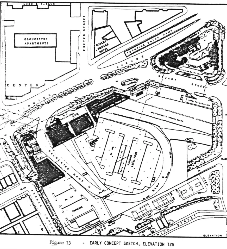
trajectory of Stuart Street from Dartmouth Street toward Huntington Avenue, and the rest of the property - except for a acre across Harcourt Street -was mere air-rights above the Massachusetts Turnpike and the Boston and Al-bany Railroad. When the State Turnpike Authority acquired Copley Place to extend its eight-lane expressway toward downtown, development in the manner of the Prudential Center (which straddles the roadway) was envisioned for the site. But although the engineers were careful to design the Turnpike as a depressed roadbed to facilitate this potential, the gesture was practically defeated when they proceeded to carve up the remaining open space of the property with a morass of exit ramps that sprayed off into three directions. Matters were further complicated by a 42" water main that ran the length of the site east to west (Figure 4).
Thus, site preparation costs imposed an expensive penalty onto the develop-ment of Copley Place. In an effort to circumvent these costs, several de-velopers had approached the Turnpike Authority with proposals to develop
only the non-air rights northeast corner. But, for the Authority, it was all or none. Those that did attempt the entire site "couldn't get the num-bers to work". Either they were unable to put together a scheme that was financially viable or their proposal was declared unacceptable by either the Authority or the City of Boston, whose own revitalization strategy
c0
L .L
min aPass otel
LIST OF SITE CONSTRAINTS
U.'
RESIDENTIAL*
A. 8. C. 0. E. F. 6. N. I. J.SOUTHWEST CORRIDOR DECK
D
TRAFFIC ONLY)
(PEDESTRIANS ONLY)
otc a flat 0
Mass. Turnpike - to remain 4
8 6 A Railroad - to be relocated Turnpike Exit Ramps - to remain S.W.C. Deck Cover - restricted use Harcourt St. (South) - restricted use Water Main
-Harcourt St. North - restricted use Ramp 0 - to be relocated
-Ramp C - to be removed Ramp 8 - to rema In
copey Place
labs. lad .. s&SITE
CONSTRAINT
had figured in Copley Place as a key factor.
Still, Boston, Massachusetts - the focus of New England's highway, rail, and air transportation network - was the trade, financial, and administrative center for more than 12.2 million people; and following three decades of virtually no commercial development, the City's investment climate had be-come heated when generous development incentives proved effective in rekin-dling private interest in the central business district. They also became a major - if not the major - attraction that has lead to the ultimate devel-opment, and design, of Copley Place.
Development Incentives
The willingness of the City to provide public incentives in order to get what it wants from private enterprise is a 300-year old tradition with Boston. In the Eighteenth Century, for example, following years of public discussion, bridges were finally built over the Charles River when citizen John Hancock and 83 stockholders were permitted to build the structures as a profit venture by charging tolls. The landfilling that constitutes nearly 60% of today's downtown area was inspired in the Nineteenth Century by a public offer to cheap fill material and free land for the contractor in ex-change for a small "kick back" (in the form of the return of a portion of the newly created property to public ownership) and adherance to certain planning stipulations.
In the 1950's, as one of the city's leading bankers was bluntly stating that no one could buy land in Boston, put up a building and make a profit, Boston was again provoked to work its persuasive powers.
Although it is likely that he was commenting on the dire market conditions of that day, this statement could also had been made in reference to the City's tax structure, which was eroding the economic base by taxing it too heavily. When the textile industries left New England for the South in the years following the Civil War, Boston became highly dependent on property taxes to finance its municipal operations. So much so, in fact, that it began to work against private re-investment in the city. A highly desir-able 1953 proposal to reclaim the Boston and Albany Railroad switching yard for the development of a huge commercial/convention/apartment complex, for example, was garroted by what the investors felt was an "extravagant de-mand" for this form of public retribution. When the development rights were transferred to the Prudential Insurance Company in 1957, their announcement to revive the proposal is what prompted the banker to make his dire predic-tion. But, as if to openly defy the nay-sayers, site preparation work began almost immediately and, amid formal ceremony, the ground was broken for the Prudential Center.
Before the steel super-structure would rise, however, all the building acti-vity on the Prudential site was halted when the developer decided to delay
further construction pending the passage of new urban development legisla-tion that it had inspired to go before the State. The pumps, which were re-quired to run day and night to keep this former marsh area from reverting to its pre-landfill natural state, were disconnected and the site was allowed to flood to protect the completed foundation work from suffereing the hazards of the weather. Meanwhile, at the State House, legislative work proceeded
to hammer out two of the most significant development incentive packages in the history of the city - the 121A Tax Agreement and the Planned Development
Area - as the concept of cheap fill and free land was revived for a Twenti-eth Century context.
Land is usually zoned in huge swatches and for only one land-use activity; but under the Planned Development Area designation, a site as small as an acre could gain multiple use, as long as the developer conformed to certain environmental design guidelines that might be requested by the Boston Re-development Authority. For doing its part, the developer gains the support of the City in its application to the Board of Appeals for a variance from any constraining zoning restrictions on the property. Meanwhile, under the provisions of the 121A Tax Agreement, the City determines the building's tax payment as a percentage of that building's gross annual income over a fixed number of years. Computing the tax in this manner is advantageous to
the developer because the tax rate is fixed and tied directly to the build-ing's occupancy instead of the assessed valuation. Since this tax break is granted only in exchange for design and development input by the BRA, the advantage to the City is that it could now encourage developers to build in
areas where they had previously been reluctant to invest, with the type of project that the City believes is necessary to fulfill its own overall de-velopment goals?
Federal development incentive programs have also been exploited by Boston. These include the Urban Renewal Program, where the City offers the developer a prime site cleared of tenants and buildings, and, later the Urban Develop-ment Action Grant (UDAG) - a direct financial subsidy to the developer that
can range into the millions of dollars. In exchange for the benefit of either of these program, however, the developer must, again, submit to the
kind of public scrutiny that yields the City the opportunity to promote its own goals and objectives through that developer's private investment.
It was under the auspices of the Planned Development Area and 121A Tax
Agreement that "Prudential Lake", following a 21-month work halt, was finally drained, and construction proceeded on the Prudential Center. Accented by the 52-story, million square foot Prudential Tower, this 32-acre complex also includes a shopping concourse, high-rise office and apartment buildings, a 1000-room hotel, convention facilities, and a 3200-car parking garage that acts as a platform to support the project above the turnpike.
By 1977 Boston was well on its way toward a full economic recovery. Public and private investments in the City approached a billion dollars a year as the focus of a region that was now specializing in the new "High Technology" and service oriented industries was shifting from the suburbs into the heart of the city. Over 18 million square feet of Class "A" office space had been built downtown since 1960 - and new construction still was not keeping pace with the ever-growing demand for this precious commodity. The number of hotel rooms in the City had also become critically deficient, and the retail sales volume in the metropolitan area, which had just increased by 35% during the previous four years, was projected to improve by another 28% by 19809
In the midst of all this excitement was Copley Place, turning away the ad-vances of one suitor after another. But, now, there was a new developer in town, one that considered the market much too strong and the location of the site much too good to let an opportunity to cash in big on Boston's pros-perity succumb to the eccentricities of a poorly design off-ramp.
Footnotes
1
"High Fashion Spine" is a play on the term "High Spine" which, accord-ing to the 1965/1975 General Plan for the City of Boston,describes the linear growth of the city's downtown. As a regional core for commercial activity, Downtown Boston consists of nine sub-centers of activity(North Station, Government Center, the Waterfront, Downtown Crossing/ Post Office Square/South Station, Park Plaza, Copley Square, Prudential Center, Symphony Hall, and Kenmore Square) that are linked via a linear circulation system. The "High Fashion Spine" would be that portion that stretches from, and including, Park Plaza to the Prudential Center. 2 Robert Hollister and Tunney Lee, Development Politics: Private
Devel-opment and the Public Interest (Washington, D.C.: The Council of State Planning Agencies, 1980), p.3 1.
3 Boston Redevelopment Authority, 1967/1975 General Plan for the City of Boston, November 23, 164, p. 1 2 7.
4 Walter Muir Whithall, Boston: A Topographical History (Cambridge, Mass.: The Belknap Press of Harvard University Press, 1975), p.4 8-5 0. To ex-pand the city's land mass in the North Station area of downtown, the Town Council encouraged private developers to fill in Mill Creek by offerring nearby Beacon Hill as the source for readily accessible ex-cavation material. When the landfilling was completed, an eighth of the property was to be returned to the City for public disposal. The planning stipulation was that the street layout was to be designed by Sir Charles Bulfinch (a foremost urban designer of that day) and that accommodations be made for the Baptist churches that had settled along the creek for the convenience of baptizing (p.78-79). Further expan-sion of the city's land mass was achieved by filling in the marshes of the Back Bay. This was accomplished through the efforts of a tripar-tite indenture between The Boston and Roxbury Mill Corporation, The Boston Water-Power Company, and the Commonwealth of Massachusetts. The actual fill operation was performed by the two private enterprise units of this partnership. But for this privelege, they had to return a siz-able portion of the newly created land to the State - which then sold the property to other private developers to gain a commendable profit from the deal (p.150-155). The planning stipulation was that the cir-culation and lot layouts follow design guidelines as dictated by the city (p.131).
5 Kenneth Halpern, Downtowns USA: Urban Design in Nine American Cities (Whitney Library of Design, 1978) p.1 8 4-1 8 5.
6 Benjamin Thompson, Copley Square Air Rights (Market feasibility and design development study for the Urban Investment and Development Company, September 22, 1977).
THE PRIVATE INTEREST
Urban Investment and Development Company (UIDC) is the real estate develop-ment subsidiary of Aetna Life and Casualty Company, "the largest
diversi-fied insurance and financial services organization in the country". Based in Chicago, the Company develops, constructs, and manages properties for its own account as well as for joint ventures and partnerships. Urban, the corporate sobriquet, cane to Boston with six regional shopping centers in the Chicago area, five self-supporting planned communities in the Denver and Chicago metropolitan areas, and Water Tower Place: a 74-story mixed-use structure that had been recently completed along downtown Chicago's magni-ficent mile.
Urban is designed and organized to take projects all the way from the nebu-lous stage of initial inquiry to the concrete stages of construction man-agement and leasing. Four departments comprise its Business Development Division to pursue, identify, and qualify projects before transferring them over to the Projects Production Division to manage the actual development, construction, and leasing: The Planning Department continuously monitors
63 of the nation's metropolitan areas that exceed a half-million in popula-tion, ranking them in 96 categories that reflect economic and real estate
market conditions. Once identified, the Corporate Financial Department pre-pares pro forma financial statements projecting capital costs and net opera-ting cash flows for up to the first ten years of a proposed project's life. If approved, the Design Services Department - with capabilities in architect-ure, land and site planning, civil engineering, and graphic arts - and the
Construction Management Department assist the necessary outside professions (such as planners, architects, engineers, contractors) in taking the project to the point of actual construction.
Although shopping centers accounted for nearly half of the Company's assets, Urban was gaining particular notoriety from its development of mixed-use structures. These are projects that house more than one land-use activity within a single building envelope. Water Tower Place was the model on which others were to be planned and developed? Located adjacent to the derrick-shaped John Hancock Building on fashionable North Michigan Avenue, this three million square foot structure was built upon an underground
park-ing garage and allocates its first seven floors to a vertical shopppark-ing center, the next two floors to office space, the following 22 stories to a Ritz Carlton Hotel, and the final 40 stories to luxury condominiums.
Unfortunately, the project began as a shaky investment. Construction started during the recession of the early 1970's. This was also a period of heavy
inflation. The price of steel climbed steeply as Urban found itself paying interest on construction loans a percentage point above the prime interest rate (which had skyrocketed to a then unheard of 12%). To further
compli-cate matters, a strike by the concrete drivers further crippled the project, forcing the workers into double shifts to make up for lost time when a
set-tlement was finally reached?
Upon completion the hard cost of Water Tower Place stood at $125 million, exceeding its original projected cost by 25%. Furthermore, serious real estate setbacks suffered elsewhere forced one of the development partners, a Boston firm that was to manage the hotel operation, out of the deal, leav-ing Urban to take over the management of the facility despite its lack of lodging experience. Meanwhile, the continued recession was pushing the con-dominium sales a year behind schedule!
Still, the shopping center was an immediate success, averaging $200 per square foot in sales with recent increases suggesting a $300 per square foot sales volume by 1980. The office component showed similar promise. Later as the nation experienced economic recovery, Water Tower Place's condo market returned with a vengence to allow price increases of $80,000 on the most expensive units, which continued to sell briskly at well over $300,000
a piece. The hotel had begun averaging a commendable 70% occupancy with daily rates ranging from $66 for the least expensive room to $750 for the most expensive suite? As an investment, Water Tower Place was paying off and Urban was ready to do it again.
From
Chicago to Boston
When Cabot, Cabot & Forbes relinquished its interest in the hotel portion of Water Tower Place, their field representative, Kenneth Himmel, was subse-quently hired by co-developer Urban to continue supervising the planning and development of that facility and was eventually elevated to the level of a corporate vice president. In 1976, Himmel was enlisted by a former
Vice President of Cabot, Cabot & Forbes, K. Dunn Gifford, to join him and Faneuil Hall Marketplace architect, Ben Thompson, in the formation of Great Bay Company, Inc., a firm committed to the development of Copley Place by acting as the local agent of a joint venture that would include Urban and Western International Hotels (Westin) as co-developers and the major in-vestors9
Their plan was ambitious: To develop Copley Place as a large-scale, mixed-use project that would encompass the entire site. Buttressed by the
im-pressive track record of Urban and the financial backing of its parent company, Aetna (which was reporting earnings of $7 billion and consolidated assets of $18.2 billion), and assured of a major tenant for the development by Westin, Great Bay won the confidence and support of the State, and, in an unusual move, was immediately designated the site's developer. Yet, securing of the property lease was still dependent upon their ability to submit a
satisfactory statement of environmental impacts, and in another unusual move, it was agreed that this statement would be produced through a process where the prediction and measurement of these impacts would occur concurrently with the master planning and design development of the project?
The designation or acceptance of a developer with the stipulation that his work be continuously monitored by public scrutiny is an innovative method of urban redevelopment known as "Front End Assessment". This was the State's
reaction to a debacle that had recently occurred when the traditional ap-proach to impact assessment turned a similar proposal to develop nearby Park Plaza into a nightmare for nearly everyone involved. In that instance, the
kit and sponsored a competition. Following its selection the chosen develop-er produced a detailed set of plans for the Environmental Impact Review (EIR). The Review did not go well. Public reaction to the plans was negative.
Cri-ticism was so intense that it delayed the State's approval of the project for three years. The developers then spent another two years completing a supple-mentary EIR. But public antagonism remained, and after a financial commit-ment estimated to be in the millions of dollars, the developer withdrew his interest in the site. By identifying and addressing public environmental concerns for Copley Place at the beginning of the development planning process (instead of near the end), it was hoped that a more acceptable de-sign would result, thus drastically reducing the complexity of the State's approval responsibility as well as the financial risk to the developer.
The Agreement
In April 1977, a Memorandum of Understanding was signed by the State Turn-pike Authority and Great Bay/UIDC, which granted the developers a six-month option on the site. During this time they were to negotiate the set of de-velopment guidelines for the project with a Citizens' Review Committee (CRC) acting as advisory to the Office of State Planning. This was to ensure that the views and values of the public be integrated into both the design and environmental studies of the project. It was also being foreseen that at the end of this time option, everyone would have a shared understanding of the constraints as well as the opportunities at Copley Place and that a proper decision could then be made by the developer and the State as to whether it would make sense to proceed into a further option.
negotia-tion to sell or lease Copley Place to any other party so long as this opnegotia-tion was in effect. But the time frame was tight: The advisory committee was
to be selected the following month, their final guidelines negotiated and completed by that September. If the developer desired to proceed, he was then to be given nine months to finalize his plans along the recommendations of the guidelines, at which point the CRC would then reconvene to evaluate the sincerity of his effort to conform to their requests and to negotiate further refinements to his plans. Based upon the outcome of this process, the CRC would finally recommend whether the Turnpike Authority should grant Great Bay the lease on Copley Place (Appendix A).
Footnotes
1 Urban Investment and Development Company, Annual Report 1970. 2 Teri F. Weidner (Manager of Communications for UIDC's Copley Place
Development), Private Interview, April 13, 1981.
3 Gary Washburn (Real Estate Editor), "Water Tower Place - Gem Sparkles More Brightly", The Chicago Tribune, November 12, 1978.
4 Ibid. 5 Ibid.
6 Weidner, op. cit.
Westin had approached the State two years earlier with a proposal to build on the non-air rights northeast triangle but failed to gain nece-ssary support for their plan.
Robert Hollister and Tunney Lee, Development Politics: Private Devel-opment and the Public Interest (Washington, D.C.: The Council of State Planning Agencies, 1980, p.3 0.
THE PUBLIC INTEREST
As Great Bay/UIDC began its development studies, The State initiated its own aspect of the planning process by designating a consultant to staff and or-ganize the CRC. Professor Tunney Lee of MIT's Department of Urban Studies and Planning was hired to fulfill this responsibility and act as moderator in the discussions between the developer and community interests.
The definition of the community was somewhat comprehensive in this stage, as the Citizens' Review Committee was composed of representatives of State, City, as well as local neighborhood interests and advocacy groups. The municipal government, for example, was represented by the BRA and Mayor's
office, while participants from the State Government included the Turnpike Authority and the Development Cabinet, which, along with the Office of State Planning, included the Offices of Transportation, Environmental Affairs, Economic Affairs, and Community and Development. The Back Bay Businessmen's Association was also represented, as well as the Massachusetts Historical Commission. In all, there were twenty-five different community groups and public agencies actively involved in this process. In addition, the negotiations were staged as an open public forum so that other parties and individuals could also express their concerns as well as contribute their input!
Three factors combined to give the CRC leverage in their negotiations with the developer: (1) Boston's investment climate, (2) the local and state political climate, and (3) the recent public protests that had proven to be an Achilles heel to both. The first factor engendered a tenacity to build, and, as the advisor to the landlord, the CRC had a very good development
site to bargain with. Back Bay is to Boston what North Michigan Avenue is to Chicago, and Copley Place was 10 acres of vacant land in the heart of Back Bay. This was Boston's fashion center. More than a hundred exclusive boutiques and three high-fashion department stores were within a five min-ute walk of the property. The retail arcade at the Prudential Center was anchored by Lord & Taylor and Saks Fifth Avenue. Bonwit Teller and Brooks Brothers were just a couple of blocks away.
In history, the Copley Place site functioned as the boundary between the aristocratic neighborhood of Back Bay and the no longer aristocratic South End (contributing the proverbial railroad tracks that each was to stay on their respective side of); and although both neighborhoods experienced de-cline during the City's extended depression period, both were now re-emer-ging as fashionable places to live. The site's proximity to the 5200-seat Civic auditorium (which had plans for expansion), further enhanced the de-sirability of the site while new mass transit improvements promised to bring Logan Airport to within a fifteen minute ride on the subway.
At the same time, political leverage was gained by the support and backing that the CRC was receiving from the Office of State Planning. The Office of State Planning, in turn, activiated its own leverage by taking advantage of their ability to obtain federal grants for the developer, their authority
to determine the building permit requirements, and the Governor's power to appoint members of public office. This last piece of leverage was mainly used to keep the public agencies in line to prevent any invitation to the developer to play one governmental actor off against another?
Park Plaza had singed more than a few political careers, and the newest state administration was anxious to dissolve the anti-development image that it had inherited from the last. The three-year delay in granting the approval for that project prompted a march by 50,000 construction workers and their supporters on the State House just two years earlier, thus making the construction unions a hidden yet influential force in the decisions about Copley Place? But, as if to counter any over-compensation, ill-fated Park Plaza also reminded the State of the effectiveness of community protest in the prevention of an unwanted development.
In the late 1960's the BRA was prevented from selling a parcel of land in the South End for luxury housing when protestors built a squatter village of make-shift tents on the site to halt what they considered to be unilat-eral gentrification of the neighborhood and demanded the construction of low-income housing, instead, to replace that which the Authority had razed. As of 1977, that site, located adjacent to Copley Place at its southern border, was still undeveloped. Another protest movement prevented the in-town extension of Interstate 95 from Route 128 when citizens became alarmed at the massive clearance that was destroying their neighborhoods. That path, which forms- the southern boundary of Copley Place, was now being utilized for Mass Transit improvements.
Both the Tent City Coalition and the Southwest Corridor Coalition were well represented on the CRC, and, along with the other groups,
associ-ations, and concerns of that body, presented a formidable threat to the ultimate development of Copley Place.
Yet, as in the case of Park Plaza, the issue among the citizens was not whether or not there should be site development (only an extreme minority preferred that Copley Place remain a grassy hole), but, rather, the form and function that the development should be allowed to manifest itself. The prospect of losing Copley Place, just as Park Plaza was ultimately lost, posed as a threat in the minds of the citizens just as it did in that of the developer. This is where the State found its leverage to prevent the planning/negotiation process from becoming an endless exercise.
A boundary was set: Time. If the CRC failed to fulfill its commitment to establish a definite set of guidelines within the agreed upon span of time, the decisions concerning the development of Copley Place were to be returned to the State, and the traditional method of developer selection,
and environmental impact evaluation, would be imposed. For the citizens, this represented a choice between having a significant say in the develop-ment of Copley Place versus having next to no say at all. Looking over at
the still empty site that was to be Park Plaza, it also meant the differ-ence between having some development, some jobs, some taxes, and some local improvements versus having nothing!
Once convened, the early sessions of the CRC were primarily educational, with representatives of various agencies as well as Gifford and Lee,
him-self, lecturing the group on such issues as local physical and social real-ities, legal requirements, and the facts of life facing the developers. They were also provided with technical assistance to ascertain
transporta-tion issues, regulatory controls and the lease process, planning issues, and the economics of real estate development. Then, with little more to go on than a sense of the scale and mixture of the land use being proposed by the developers, the CRC tried to anticipate the impacts of the major fea-tures of the plan and formulated its initial set of development guidelines. At the end of June, these guidelines were presented to the developers to begin the summer-long session of negotiations that was to end with the pre-sentation of their final recommendations for development guidelines to the Turnpike Authority.
Footnotes
1 "Lee's basic approach was to 'bring everyone in the Citizen's Review Committee up to the same level of understanding of the issues involved', and to make community concerns as explicit as possible as soon as
possible. While recognizing that participants would retain differences of opinions and of goals, he nevertheless felt that a substantial in-crease in the body of shared knowledge about the project would reduce areas of disagreement. Equally important, it would provide a more solid basis for negotiation".
Robert Hollister and Tunney Lee, Development Politics: Private Devel-opment and the Public Interest (Washington, D.C.: The Council of State Planning Agencies, 1980), p.2 3 and 34-35.
2 Ibid., p.19-20 3 Ibid., p.31
4 Converstion with Tunney Lee, June 20, 1982. 5 Hollister and Lee, Op. Cit., p.35
DESIGN GENERATION:
Initial Schemes
The design development studies for Copley Place took the form of an iterative planning process within the development team before proceeding into the nego-tiations with the community that summer. This was a time spent ascertaining the general feasibility of the project.
Between Great Bay and Urban, the focus of attention was the basic design is-sues of land-use, massing, and the proposed inter-relationship of the proj-ect's major components. As the master planner, Thompson would devise a de-velopment concept and present it to Urban. As the prime investor, Urban would then examine the concept, discern its approximate cost and marketabil-ity, then return the plans to Thompson with a statement of their concerns. The plans were then modified to address these concerns. Thus, the cycle of presentation -response-modification would continue until a consensus was finally reached.
The program for devising the concept for development was vague: retail as the central activity augmented by the Western International Hotel, office space, and a parking garage. The amount of retail space and its style of merchandising, the type of hotel and its number of rooms, the size and
con-figuration of the office space, and the capacity of the parking garage were all to be determined through this "trial and error" method of planning. Yet, this is not to imply that the design development of Copley Place began on an immaculately clean slate.
As stated elsewhere, Urban had something like their Water Tower Place project in mind. At less than two years old, Downtown's Chicago's newest shopping center had already begun to exceed the economic expectations of its owners?
setting a precedent for what they wanted to see happen in the Back Bay. Still, the open-endedness of the development program at this stage afforded Thompson an opportunity to incorporate many of his own ideas into the plans that he formulated for the project. Thompson was the master plan architect for Downtown Boston's newest shopping center - Faneuil Hall Marketplace, which was the culmination of a ten-year struggle that had been waged to
pre-serve and properly restore the structures that house the restaurants and shops that make up this facility. Thus, he had every right to be confident in his vision for Copley Place, also.
Faneuil Hall Marketplace and Water Tower Place had both become widely re-garded as significant landmarks in downtown revitalization. Still, they represent divergent approaches to commercial development. As the progeny of these ap riori conceptions, the early plans for Copley Place graphically illustrate the difficulty that was encountered in trying to merge the two.
The Faneuil Hall Marketplace
Faneuil Hall Marketplace consists of three 535-foot long buildings that were built in 1824 as extensions of Faneuil Hall, Boston's first public
market. The central structure, Alexander Parris' vigorous Greek Revival Quincy Market, served as a public market and meeting hall. The two
an-cillary structures, called North and South Market buildings, were inde-pendent rows of attached commercial offices and warehouses. The market's prosperity faded after the turn of the century and its site, in the 1960's, would have been cleared had not a contingent of historic and urban
con-servation concerns won the support of the City for the proposal to re-vitalize the marketplace as a complete food and restaurant complex
augment-ed by shops, kiosks, and mobile vendors?
As the founder of Design Research, a trendy boutique selling housewares and fabrics made famous by its imaginative display of merchandise, Thompson had already shown a penchant and skill for bringing together different kinds of goods in a marketplace setting. However, Faneuil Hall Marketplace was
seen to be more than just another interaction between people and goods. Here, he saw a urban issue that involved social dynamics, as well. There had to be a sensitivity for the interaction between the place and its en-vironment. Following Thompson's idea of environmental design, Faneuil Hall Marketplace (while designed to be an exciting entity in and of itself) was
thus planned to become a vital link in the pedestrian system that already permeated Downtown. Its role: To tie the massive plaza of the City Hall to the activities that were being generated by the redevelopment that was occurring along the waterfrontf
Still, the issue of merchandising remained critical, especially when it came to convincing lenders for financial support. The 1960's was an era of
In addition to the fear an uncertainty that this provoked in the concept of retailing in urban areas, Thompson's development scheme for the Marketplace was also unconventional, thus raising a few eyebrows on its own. Shopping centers are usually anchored by at least two major tenants that act as magnets to attract customers as well as additional stores. This minimizes the banker's risk in the project. But the Marketplace was to have no such arrangement. Here, a conglomeration of small establishments were to be strategically selected and placed within the project so that the Market, as a whole, would become the attraction. Thompson also figured that since each tenant was to lease such a small selling area, the sales per square foot would then optimize the rent per square foot that each of these ten-ants could afford to pay.
Needless to say, this scheme and these calculations called for a kind of imagination that few developers, and even fewer bankers, were willing to risk. This, however, did not deter Thompson from wanting to direct the development of the Marketplace according to the design and merchandising principles that he believed would insure its success. The first developer
that he associated with in this venture failed to secure the necessary backing from the financial community, which only served to further convince those that he subsequently approached with the proposal that his ideas were infeasible9
Finally, in the spring of 1972, one of Thompson's developer contacts di-rected him to see James Rouse, Chairman of the Board of the Rouse Company - one of the nation's leading real estate and mortgage banking firms.
Although the Company's primary focus at the time was on suburban shopping malls and new communities, Mr. Rouse was beginning to express a personal belief that the future held great opportunities for downtown development. He accepted Thompson's offer.
It took nearly six months of intense effort for Thompson and Rouse to get the BRA to designate The Rouse Company as the developer for Faneuil Hall Marketplace. Even then, the development proposal had to be compromised, somewhat, to include a major tenant (a 10,000 square foot creperie restau-rant) in order to secure the development loan. Yet, this represented only a slight transgression to Thompson's original scheme, and in its completed form, The Marketplace embodied much of the precepts that he had fought so
long and hard to protect.
According to the rules of modern shopping center development, Faneuil Hall Marketplace was not supposed to work. The scale is small and tight.
Pedes-trian circulation areas are narrow and become choked to the point of impeding movement. Seating is inadequate, forcing patrons to vie for seating on
any-thing from ledges and planters to trash recepticals. One can barely move through the shops without knocking against the merchandise. The office spaces are similarly cramped. Vehicular accessibility is confusing, parking is scarce, and there is only bare separation between service and visitor traffic. There are no department stores. There is no modern air-condition-ing. The outdoors of the project was given as much design and planning pri-ority as the indoors to merge the project into its local environment.
its more than 150 shops each year, making it the largest tourist attraction in the nation. Merchants were reporting monthly sales of $400. per square foot, while The Rouse Company, which charges its tenants a rent based upon a certain percentage of their sales, was getting a return on its investment at a rate of 200% that which was normally received on retail space in one of their typical suburban centers.
The Water Tower Place
If Faneuil Hall Marketplace had tamed conflict and confusion into an attrac-tion, Water Tower Place had them exterminated altogether. As another
lead-ing building of suburban shopping centers and new communities, Urban developed this North Michigan Avenue showpiece following all the rules.
The 816,000 square foot Atrium Mall forms the massive base for the Water Tower Complex. More than 150 stores are embedded within this seven-story facility, including two major department stores that act as anchors. The
shopping environment is totally enclosed and climate controlled. The urban environment in which it is situated has been, for the most part, ignored.
A "cascading garden" -two floors worth of escalators, plants, and fountains
- draw people in from the street level to the main floor of the "Grand Atrium" where their attention is then grabbed by a shiny glass elevator
shaft that slickly rises through the full height of the interior court. A large built-in garage provides adequate parking below this structure.
The Atrium Mall at Water Tower Place proved to be a success, prompting its developers to immediately start looking for another such opportunity, but
in terms of urban planning, the development, as a whole, was generating critics. It was being described as being too big for its particular loca-tion. The huge base pressed up against the lot lines on all four sides, and this mass, plus the tower, added up to more floor area than the 100-story John Hancock Building in the next block. In a 1967 beautification
study for Chicago's "Magnificant Mile", landscape architect, Lawrence Halprin, had cautioned that a wave of new tall buildings "...will completely destroy what remains of the humane scale of the street". Buildings like the John Hancock "should not be allowed to appear continuously along the street" but should instead be "regarded as landmarks"1.0 It was also being criticized as being "too commercial, not really a suitable resident of the City's ele-gant Michigan Avenue"'1 On the other hand, Water Tower Place proved to have a positive effect on the commercial activity reported by the shops along
that Avenue.2 It was also receiving praise as a "lively new experiment in retailing; an exciting kind of skilled and thoughtful architectural inter-vention into a tough and competitive business"13 As a precedent for Copley Place, this last statement likely describes what Urban had in mind for the
Back Bay.
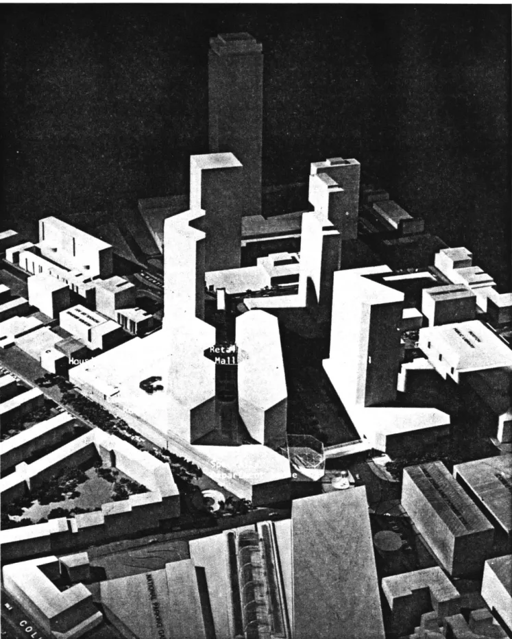
The Place at Copley
The initial development schemes for Copley Place reflect many of the pre-cepts that influenced the design development of the Faneuil Hall Market-place (Figure 5-11). An elaborate system of walkways and courtyards, for example, illustrate an emphasis on pedestrian connections that go beyond tying together the components of the development program to tie the site to the neighborhoods, commercial centers, and other activity nodes nearby. Although large buildings were included as part of the plans, the impact of
1
c'~~per
(
0jcKoa~
Figure 5
-SCHEME #001
0 0 c o (D -0 0 -) (D 0-0 Drt 0) c -h-(Dt 01C et -00- SCHEME #002 0 0 m(D t -o 0 -1 ono
Oo
'0 rt m rt Srt m c - CL (o -n-C) MA&OU 417E qFigure 6
p -Lai LJ Copley Place Concept Study, 5/77 Copley Place Draft EIR/EIS,
2/15/80
U -;AA 00 Copley Place Concept Studies,
5/77
Copley Place Draft EIR/EIS, 2/15/80C O o TU (D (b 0) a) .< < (U (D W Gi C1 OV (D rt r1MC RO_ (D-T
]'gr 9/HME#0
:6,
3 I 2 .00 3t &=?me /
d'?j
U I -Copley Place Concept Studies, 6/77 Copley Place Draft EIR/EIS, 2/15/80nc,')
0 0
Cp C-)
,LA
co :3 1)l~tAL K FtN
at foost fol 10 Per 4ILma
5913.msS
o
c
Fige11
-SCHEME #103
their size was to be minimized by stepping them away from the most sensi-tive edges of the site (the South End neighborhood and Copley Square).
In these schemes, Copley Place was proposed to be developed as a retail cen-ter anchored at Harcourt Street by an office tower and on the northeast tri-angle by the Westin Hotel. The retail core was to be built atop a parking garage that spanned the Turnpike, railroad, and water main in the same air-rights manner of the Prudential Center. In addition, portions of the office building were to span Harcourt Street; parts of the hotel, Stuart Street. Areas for two department stores were designated along the southern boundary of the project.
Urban's reaction to this proposal was not positive. They requested that the program be expanded to absorb the costs necessitated by bridging over the site obstructions. Revisions were also requested to bring the scheme further
in line with modern shopping center standards:
1. The department store layout and arrangement were inadequate, pro-viding stores of insufficient size and street frontage;
2. The plans were too disjointed or not satisfactorily integrated among the program parts (i.e., hotel, office, retail parking); 3. The hotel and retail mall plans provided insufficient or
dis-functional access for vehicles;
4. The parking was inadequate and inefficient;
5. A number of plans contained an office building, which had a config-uration of being too narrow and, in the developer's opinion, dif-ficult to market;
service, and;
7. There was an over emphasis on outdoor pedestrian circulation, in-consistant with contemporary design standards required by major retailers!4
Urban also identified technical problems with the initial schemes which in-cluded conflicts between the site entrances and access points with the Turn-pike ramps, and insufficient clearances provided over the ramps as well as for the pedestrian walkways.
The plans were revised along these concerns as Great Bay, representing the development team, prepared to begin its negotiations with the CRC. It was also at this time that Urban realized that public financial support would be required to help cover the hard costs of site preparation and special engineering that came along with building over an active turnpike and rail-road bed. Traffic could not be disrupted during the construction, and the developer was to be held responsible for any loss in revenue from toll
15 collection that could be attributed to his project.
Since the State owned Copley Place, Boston city zoning laws did not apply to this site. Land use was to meet the approval of the CRC. Since Urban's request for a UDAG grant and/or a 121A Tax Agreement was to result in addition-al public scrutiny (note that these applications had to be made through, and approved by, the City), the stage was set for a lively round of bargaining.
Footnotes
1 Teri F. Weidner (Manager of Communications for UIDC's Copley Place Development), Private Interview, April 13, 1981.
2 Gary Washburn (Real Estate Editor), "Water Tower Place - Gem Sparkles More Brightly", The Chicago Tribune, November 12, 1978. 3 Boston Redevelopment Authority, 1965/1975 General Plan for the City
of Boston, November 23, 1964, p. 1 3 5.
Mildred F. Schmertz, "Faneuil Hall Marketplace", Architectural Record, December 1977, p.1 1 6-1 2 7.
4 Jane McC. Thompson, "Boston's Faneuil Hall", Urban Design International, November/December 1979.
5 Schmertz, op. cit. 6 Ibid.
7 Ibid. 8 Ibid. 9 Ibid.
10 Kenneth Halpern, Downtown, USA: Urban Design in Nine American Cities (New York: Whitney Library of Design, 1978), p.8 1.
11 Architectural Record, April 1976, p.13 6-14 0. 12 Architectural Record, October 1977, p.9 9-1 0 3.
13 Ibid.
14 Urban Investment and Development Co., Copley Place - Project Information: Final Design (October 2, 1980), p.6.
15 Ibid.
Kenneth Himmel, M.I.T. Lecture, April 1980.
Amended and Restated Lease, Massachusetts Turnpike Authority to Urban Investment and Development Co., of Copley Place. Boston, Massachusetts.
DESIGN GENERATION:
Negotiations
Negotiations between the developer and the community began in late June 1977 with Great Bay presenting its preliminary sketches and the Citizens Review
Committee presenting a preliminary set of guidelines for what they perceived to be an ideal development package for Copley Place. This inaugurated the summer-long series of workshops that was to lead to the CRC's presentation of final recommendations for development guidelines to the State in the fall.
Between the developers and the community, the focus of attention was expanded significantly beyond that which was shared within the developer team proper as private citizens related their anxiety and concerns over such complex
is-sues as neighborhood de-stabilization, local employment, traffic generation, pedestrian access, and effects on existing commercial activity as well as
land use, massing, and the inter-relationship of the project's major compon-ents.
The project had remained essentially low rise with the towers relegated to Huntington Avenue, away from the sensitive edges of the site. Strong
ped-estrian links to Copley Square and the Prudential Center also remained; al-though such connections to the adjacent neighborhoods were no longer pro-vided. The department stores were given more prominent roles in the mer-chandising scheme, and the mall areas were enclosed for climate control,
There was also a decision to delete Parcel "C" from the development pro-gram.
As a vacant site, and a gaping hole, Copley Place allowed for the natural ventilation of the Turnpike and railroad tunnels that burrow beneath the
Prudential Center, to the west, and the John Hancock garage structure, to the east. Since complete site development coverage would effectively plug this hole up and necessitate the reinstatement of the ventilation system by mechanical means - which would become the responsibility of the developer
and thus further increase the hard cost of the project, Parcel "C" was eliminated from the development program so that a natural system for fume exhaust could remain!
The CRC opposed this decision believing that the hole would be functionally and aesthetically unacceptable for such a comprehensive development. In-sisting on full site coverage to "functionally integrate pedestrian movements from the South End and Back Bay Station to Copley Square and the Prudential Center and to provide visual and functional continuity along Dartmouth
Street", the development of Parcel "C" became one of their primary recommend-ations for the final guidelines?
Another issue of contention, and that which proved to be'the highlight of the summer, was the CRC demand that the land-use scheme for Copley Place be expanded to include a housing element. Residents of the adjacent neighbor-hoods were concerned about gentrification- the eviction of low income families
in favor of those that can afford higher rents and mortgages. To address these concerns, the CRC proposed that the developer provide housing to accommodate the influx of newcomers that was expected to be generated by