HAL Id: hal-00299194
https://hal.archives-ouvertes.fr/hal-00299194
Submitted on 4 May 2005
HAL is a multi-disciplinary open access
archive for the deposit and dissemination of
sci-entific research documents, whether they are
pub-lished or not. The documents may come from
teaching and research institutions in France or
abroad, or from public or private research centers.
L’archive ouverte pluridisciplinaire HAL, est
destinée au dépôt et à la diffusion de documents
scientifiques de niveau recherche, publiés ou non,
émanant des établissements d’enseignement et de
recherche français ou étrangers, des laboratoires
publics ou privés.
Multidisciplinary co-operation in building design
according to urbanistic zoning and seismic microzonation
M. Bostenaru Dan
To cite this version:
M. Bostenaru Dan. Multidisciplinary co-operation in building design according to urbanistic zoning
and seismic microzonation. Natural Hazards and Earth System Science, Copernicus Publications on
behalf of the European Geosciences Union, 2005, 5 (3), pp.397-411. �hal-00299194�
Natural Hazards and Earth System Sciences, 5, 397–411, 2005 SRef-ID: 1684-9981/nhess/2005-5-397
European Geosciences Union
© 2005 Author(s). This work is licensed under a Creative Commons License.
Natural Hazards
and Earth
System Sciences
Multidisciplinary co-operation in building design according to
urbanistic zoning and seismic microzonation
M. Bostenaru Dan1,*
1Universität Karlsruhe (TH), Germany
*European School for Advanced Studies in Reduction of Seismic Risk (ROSE), Istituto Universitario di Studio Superiori,
Università degli Studi di Pavia, Italy
Received: 27 September 2004 – Revised: 24 March 2005 – Accepted: 18 April 2005 – Published: 4 May 2005 Part of Special Issue “Multidisciplinary approaches in natural hazard and risk assessment”
Abstract. Research and practice in seismology and urban
planning interfere concerning the impact of earthquakes on urban areas. The roles of sub-area wide or typological divi-sions of the town were investigated with the methodology of regression, regarding their contribution to urban earthquake risk management. The inductive data set comprised recov-ery, preparedness, mitigation and resilience planning. All timely constituted planning types are refound today as layers, as the zoning results are used by differently backgrounded actors: local authorities, civil protection, urban planners, civil engineers. In resilience planning, the urban system is complexly theoretised, then integratedly approached. The steady restructuring process of the urban organism is evi-dent in a dynamic analysis. Although expressed materially, the “urban-frame“ is realised spiritually, space adaptation being also social. A retrospective investigation of the role of resilient individual buildings within the urban system of Bucharest, Romania, was undertaken, in order to learn sys-temic lessons considering the street, an educational environ-ment. (In)formation in the study and decision making pro-cess stay in a reciprocal relationship, both being obliged in the (in)formation of the public opinion. For a complete view on resilience, both zoning types, seismic and urbanistic, must be considered and through their superposition new sub-area wide divisions of the town appear, making recommendations according to the vulnerability of the building type.
1 Introduction
Natural, engineering and social sciences contribute to the evaluation of the earthquake impact on urban areas. Inter-ference areas seismology-urbanism regard:
– assessment techniques, like seismic microzonation (”an
estimation procedure of the total seismic hazard from Correspondence to: M. Bostenaru Dan
ground motion and related phenomena accounting for the effects of local site conditions” Parvez et al. (2004));
– planning instruments for visualisation and for the
strat-egy development/implementation in both pre- and post-disaster intervention, like urban zoning;
– partnerships models between the actors involved in
de-cision making for risk management.
Local site conditions (ex. near surface geological condi-tions or topography) can, additionally to distance effects, am-plify/reduce the peak ground acceleration (PGA) site value. Building codes in earthquake prone areas account for local site conditions, using a categorisation into site classes of sub-surfaces and parameters like sediment infills in irregular ge-ological structures. Long distance earthquakes can have dis-astrous effects on high-density urban settlements, if alluvial soil deposits amplify the ground motion. The microzona-tion increasingly contributes to seismic risk evaluamicrozona-tion in ur-ban areas. Urur-ban microzonation is researched by the groups of Parvez et al. (2004), Moldoveanu et al. (2004), Panza et al. (2001), Ansal (2002), and Faccioli and Pessina (2003). Parvez et al. (2004) initiated a project towards an integrated expert system, to use seismic microzonation parameters to-gether with information on the earth, environmental, socio-economic and political systems, in urban planning processes, when elaborating land-use maps, able to provide well esti-mated seismic inputs for earthquake resilient building design. Parvez et al. (2004) recognised the multidisciplinarity of this work, requiring input from seismology, history, archaeology, geology and geophysics. Parvez et al. (2004) proposed a first level microzonation map using microtremor measurements and a second order one using measured or numerically sim-ulated seismic hazard parameters (PGA, PeakGroundVeloc-ity) relevant for seismic building design in urban areas.
Urban planners might have kept silent because they took only functional and aesthetical aspects, not natural hazards, in account for zoning (Bademli, 2001). Indeed, the 1933 Chart of Athens (CIAM, 1946) stipulated leadership for the
398 M. Bostenaru Dan: Multidisciplinary co-operation according to urbanistic zoning and seismic microzonation zoning principle in modern, functionalist cities. Wide
appli-cation in the second half of the XXth century made the nega-tive side of mono-functional zoning visible (Bohning, 1981). But, the necessity for functional order had leaded to zoning preoccupations before the concept was constituted. Ordering of “urban-life“ elements resulted along time as an organisa-tional necessity. In the historic town, the spontaneous divi-sion of the urban territory after destination, for population and activities security, found step-by-step the way to institu-tionalisation. Today, not to negate zoning entered the reper-tory of urbanism courses (Sandu, 1995a, 1995b, 19971), the urban organism being analysed as a complex system:
1. morphologically, with two elements:
– ”urban-life” (content): totality of localised urban
activities, related into the urban functional struc-ture. This transformation generator is a human activity system, not concentrated on, for example, central or residential activity;
– ”urban-frame” (container): totality of spaces
cor-responding to localisation, related in functional-spatial co-operation into the urban functional-spatial structure. They become through substantialisation ”life-way” and ”life-frame”, calling inter-/multidisciplinary research constituted on two inter-conditioned layers:
– spatio-functional, on phenomenological
“urban-life“ level,
– spatio-perceptual, on physical “urban-frame“ level.
The existence“ is a manifestation of the “urban-form“. The momentan “urban-existences“ (“urban-states“) are concretisations of certain “urban-structures“ and build local manifestations in an “urban-situation“. 2. (structural)-functionally, the town is constituted based
on the ”urban-activity” (ex. residing), closely connected to the land-use (ex. residential). The “urban-activity“ is preceded by the human ”mobile”, which evolves dur-ing the existence of an urban organism to a totality of ”urban-forces”. Economic, social, political, aesthetic “urban-forces“ lead to space determination through de-cision/action. The human ”mobile” gives the initial im-pulse, but the activity dimensions an urban space. 3. dynamically, the urban form is a concretisation in time
and space, static or dynamic, of the urban phenomenon as a system: spatial forms, forms of territorial organisa-tion and of “urban-life“ (psycho-social, economic etc). Sandu (1995b) proposed a heterogeneous urban model in which a zone has instead of a unique function a unique vocation. Urban zoning (”division of an urban settlement into parts in the functionality of which a unitary character
1Sandu, A: ”Urbanistic doctrines”, course notes, ”Ion Mincu”
Architecture Institute, Bucharest, Romania http://www.iaim.ro/ discipline/?id=1125, 1995a, respectively ”Urban structure”, http: //www.iaim.ro/discipline/?id=1192, 1995b, ”Urban composition”, http://www.iaim.ro/discipline/?id=1120, 1997.
is recognisable, actively reported to the ambiance”, Sandu, 1995b) results as a structural product in the superposition and interpenetration of textures (”sub-systems of the life-frame elements able to respond to the functionally requested situa-tion, an analytic instrument of morphological decomposition of the urban structure in urban theory”, Sandu, 1995b) of morphologic elements, thanks to the co-operation process of human activities in the urban territory. The ”character-of-a-zone” is defined by all the texture categories encompassed, and by the texture with the highest land-use value. This dom-inant character is given by the prior function in the zone, which co-operates with the others through the unifying ho-mogeneity of the structure, assuring the heterogeneity of the “urban-life“ and “urban-frame“. There is a complex urban zoning with operational and organisational value.
Representatively for the multidisciplinary co-operation potential in earthquake impact reduction strategies for urban areas and infrastructure, the zoning as instrument in engi-neering seismology and urban planning was chosen. Aimed was to learn lessons for the urban system regarding the roles of sub-area wide or typological divisions of the town, based on the role of resilient individual buildings.
2 Background
Bucharest lays in the Romanian Plain, centrally on the Moe-sian Platform. Moldoveanu et al. (2004) described the Bucharester topography as a plane sloped in the SE direction of two river flows, dividing it into morphological units:
– the Dâmbovi¸ta and Colentina meadows, – the Dâmbovi¸ta-Colentina interstream,
– the Cotroceni-V˘ac˘are¸sti, B˘aneasa-Pantelimon plains.
A hazard for Bucharest, at an average epicentral distance of 160 km, are intermediate-depth earthquakes originating in Vrancea, where four tectonic structures intersect: the East-European Plate, and the Moesian, Black Sea, Intra-Alpine/Pannonian-Carpathian sub-plates (Soloviev et al., 2000). The socio-economic development of the capital leaded to intensive urbanisation in the centre of Bucharest around 1900 and between the World Wars. The architect Marcel Iancu wrote a manifesto stipulating the organisation of the capital into zones: city centre, central-residential, low-cost housing, and industry; an “utopia“ which found way to practice in the 1934 Master Plan for Bucharest (Mache-don and Scoffham, 1999). Romanian Modernism adopted the principle of zoning from the urban theory (1933 Charter-of-Athens). Functional zoning was a main endeavour to be reached by giving the Master Plan ”the power of law” (Machedon and Scoffham, 1999) in 1939, when building reg-ulations were introduced.
In the interwar time, numerous high-rise buildings in “Modernism“ style were constructed, to accommodate the growing rich population moved to the city. Employing ad-vanced construction technology of the time was common place, but the possibilities of the materials and systems had
M. Bostenaru Dan: Multidisciplinary co-operation according to urbanistic zoning and seismic microzonation 399 not been yet researched enough. In 1940 a first strong
Vrancea-earthquake (Mw=7.7) affecting Bucharest “tested“
these buildings. The reinforced concrete skeleton buildings along the main boulevards in the centre suffered most. In 1977 another strong Vrancea-earthquake (Mw=7.4), leaded
to greatest destruction in Bucharest.
Moldoveanu et al. (2004) reviewed seismic microzona-tions of Bucharest performed after 1940. Seismic microzon-ing maps were drawn prior to 1977 after Russian model, con-sidering the influence of the surface soil layer and water table level on the building behaviour. Three microzones following the geomorphologic units resulted:
1. the city centre: MacroSeismic Intensity=7-8, 2. the Dâmbovi¸ta and Colentina meadows: MSI=8, 3. the Cotroceni-V˘ac˘are¸sti, B˘aneasa-Pantelimon plains
and Dâmbovi¸ta-Colentina interstream (rest): MSI=7. As the 1977 Vrancea-earthquake damage distribution, evalu-ated by inspection and analysis of the building stock accord-ing to the load-bearaccord-ing structure (Mândrescu and Radulian, 1999) or to the empirically estimated fundamental period (Sandi and Perlea, 1982), infirmed this microzoning map, another was proposed (earthquake intensity according to the damage level, independent of the subsurface geological con-ditions): a concentrical distribution of the PGA decreasing from centre to periphery (Moldoveanu et al., 2004). The 1977 pattern was infirmed by the PGA values and the spectral content of the instrumental records for the 1986 (Mw=7.2)
and 1990 (Mw=6.9) earthquakes (Mândrescu and Radulian,
1999). Recently, Cioflan et al. (2004) performed a study based on instrumental observation, interpretation of the site effects, and numerical modelling, calibrated with recorded seismograms. The results were extended to city regions with similar geological structure, dividing the city area into non-concentrical zones, to which representative response spectra were assigned. The records of a moderate earthquake which struck Bucharest on 27 October 2004 await evaluation.
3 Methodology
The built substance in Bucharest was analysed both typologi-cally and sub-area wide, employing urban area survey meth-ods, which allowed identifying the morphological types in the building stock (Bostenaru and Gehbauer, 2004). The “in-terwar“ building class, that constitutes an architectural land-mark, but proved to be the most vulnerable to earthquakes, being founded on alluvial soft soil deposits with high ground water level and having in most cases a seismically inadequate conformation, has potential to prove how early multidisci-plinary collaboration resulted in better performance. Con-clusions drawn through investigation with means of individ-ual disciplines can be put in dialogue in a multi-, inter- or cross-disciplinary manner (Bostenaru, 2004b), as sketched in Fig. 1a. A regression was made (Fig. 1b).
M. Bostenaru: Multidisciplinary cooperation in building design according to urbanistic zoning and seismic microzonation 3 place, but the possibilities of the materials and systems
hadn’t been yet researched enough. In 1940 a first strong Vrancea-earthquake (Mw=7.7) affecting Bucharest ‘tested’
these buildings. The reinforced concrete skeleton buildings along the main boulevards in the centre suffered most. In 1977 another strong Vrancea-earthquake (Mw=7.4), leaded
to greatest destruction in Bucharest.
Moldoveanu et al. (2004) reviewed seismic microzona-tions of Bucharest performed after 1940. Seismic microzon-ing maps were drawn prior to 1977 after Russian model, con-sidering the influence of the surface soil layer and water table level on the building behaviour. Three microzones following the geomorphologic units resulted:
1. the city centre: MacroSeismic Intensity=7-8, 2. the Dâmbovi¸ta and Colentina meadows: MSI=8, 3. the Cotroceni-V˘ac˘are¸sti, B˘aneasa-Pantelimon plains
and Dâmbovi¸ta-Colentina interstream (rest): MSI=7. As the 1977 Vrancea-earthquake damage distribution, evalu-ated by inspection and analysis of the building stock accord-ing to the load-bearaccord-ing structure (Mândrescu and Radulian, 1999) or to the empirically estimated fundamental period (Sandi and Perlea, 1982), infirmed this microzoning map, another was proposed (earthquake intensity according to the damage level, independent of the subsurface geological con-ditions): a concentrical distribution of the PGA decreasing from centre to periphery (Moldoveanu et al., 2004). The 1977 pattern was infirmed by the PGA values and the spectral content of the instrumental records for the 1986 (Mw=7.2)
and 1990 (Mw=6.9) earthquakes (Mândrescu and Radulian,
1999). Recently, Cioflan et al. (2004) performed a study based on instrumental observation, interpretation of the site effects, and numerical modelling, calibrated with recorded seismograms. The results were extended to city regions with similar geological structure, dividing the city area into non-concentrical zones, to which representative response spectra were assigned. The records of a moderate earthquake which struck Bucharest on 27.10.2004 await evaluation.
3 Methodology
The built substance in Bucharest was analysed both typologi-cally and sub-area wide, employing urban area survey meth-ods, which allowed identifying the morphological types in the building stock (Bostenaru and Gehbauer, 2004). The ’in-terwar’ building class, that constitutes an architectural land-mark, but proved to be the most vulnerable to earthquakes, being founded on alluvial soft soil deposits with high ground water level and having in most cases a seismically inadequate conformation, has potential to prove how early multidisci-plinary collaboration resulted in better performance. Con-clusions drawn through investigation with means of individ-ual disciplines can be put in dialogue in a multi-, inter- or cross-disciplinary manner (Bostenaru, 2004b), as sketched in Fig. 1a. A regression was made (Fig. 1b).
(b) planning stages as layers geophysical system element social system element urbanistic system element recovery planning resilience planning mitigation planning prepared-ness planning induction + deduction = regression data set hypothesis hypothesis and derivated hypotheses statements particular cases Know-how hypothesis zoning as Integration sub-area wide division typological division
multi-disciplinary approach = a programmed approach
from the point of view of more disciplines. The study object is regarded separately by each discipline and so each discipline draws out its own conclusions. Finally the conclusion is compiled by the leader of the research group. (Sandu) object discipline A discipline B discipline C conclusion A conclusion B conclusion C compiled conclusion (def)
interdisciplinary approach = an approach where the
researchers looking to the study object have been trained about the way of approach and the vocabulary of the disciplines with which they collaborate. The programme exists thus before the approach to the problem. The result is an unique conclusion, where the components originating from a discipline or another cannot be distinguished anymore. (Sandu)
object discipline A discipline B discipline C one conclusion (def)
cross-disciplinary approach = an approach where the
on in researcher has got habits from different fields -supperposion through doctorate or advanced studies of different formations or through formation in schools with transdisciplinary specific. (Sandu)
object one conclusion
(def)
(a)
Fig. 1. (a) Definitions; (b) Regression procedure elements: induc-tion, comprising analysing a data set and formulating a hypothesis based on the observations made (characteristics and criteria were deducted based on analysis of existing projects, while know-how was derived by means of scientific disciplines, see Joedicke (1976)); deduction, where a general hypothesis is drawn out from the one formulated through induction, then hypotheses are formulated, to derive statements for a particular case.
Fig. 1. (a) Definitions; (b) Regression procedure elements: induc-tion, comprising analysing a data set and formulating a hypothesis based on the observations made (characteristics and criteria were deducted based on analysis of existing projects, while know-how was derived by means of scientific disciplines, see Joedicke (1976)); deduction, where a general hypothesis is drawn out from the one formulated through induction, then hypotheses are formulated, to derive statements for a particular case.
400 M. Bostenaru Dan: Multidisciplinary co-operation according to urbanistic zoning and seismic microzonation
4 M. Bostenaru: Multidisciplinary cooperation in building design according to urbanistic zoning and seismic microzonation
(c)
(a) (b)
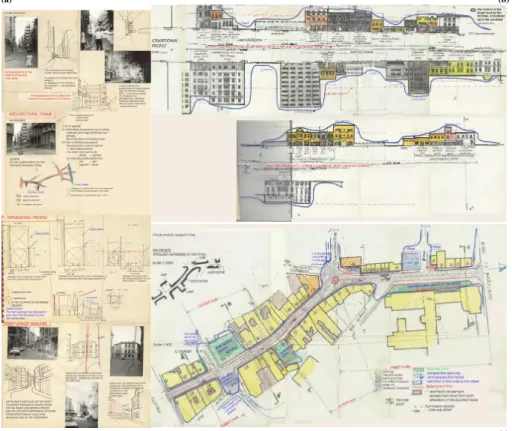
Fig. 2. Architectural frame of a street: (a) floor, background, transversal profile and image analysis; (b) longitudinal profile; (c) parcours.
3.1 Zoning in planning models for disaster management
The systemic approach, employed to determine the func-tional structure of a participative decision model, builds a good communication basis among the participants in the seis-mic risk management process. The ’urban-form’ displays an active character in its historic selectivity, resulting in the po-tential to indicate an urban strategy. The theoretical scaf-fold therefore is offered by the dynamic interpretation of the town. The elements of ’urban-frame’ are functionally de-termined or formal-compositionally determinant, an example for the later being the ‘perspective dominant’, or the rhythm (Fig. 2a). The ’urban-form’ is more than urban volumetry: an environmental factor complexly related to the life qual-ity, along with the urbanistic conceptions and urban poli-tics, essential for the urban culture. At the level of
deci-sion (Fig. 3) or conception, a solution for a certain ‘urban-existence’ has to take into consideration the spatial manifes-tation of the ‘urban-form’: the data, the problem approach, solutions, plastic modalities, and the succession of the im-plementation phases. The data set investigated within the in-duction process of this research extends the object of disaster management planning through the view on the planning sys-temic (Fig. 4a). For each planning type a successful interna-tional example was analysed, followed by the investigation of the availability of a related approach for Bucharest.
3.1.1 Recovery planning
At post-disaster reconstruction stage, land-use and physical planning activities are employed. Baroque urban plans, after the 1693 Noto-earthquake (Coburn and Spence, 2002), 1746
Fig. 2. Architectural frame of a street: (a) floor, background, transversal profile and image analysis; (b) longitudinal profile; (c) parcours.
3.1 Zoning in planning models for disaster management
The systemic approach, employed to determine the func-tional structure of a participative decision model, builds a good communication basis among the participants in the seis-mic risk management process. The “urban-form“ displays an active character in its historic selectivity, resulting in the potential to indicate an urban strategy. The theoretical scaf-fold therefore is offered by the dynamic interpretation of the town. The elements of “urban-frame“ are functionally de-termined or formal-compositionally determinant, an exam-ple for the later being the “perspective dominant“, or the rhythm (Fig. 2a). The “urban-form“ is more than urban vol-umetry: an environmental factor complexly related to the life quality, along with the urbanistic conceptions and urban pol-itics, essential for the urban culture. At the level of deci-sion (Fig. 3) or conception, a solution for a certain “urban-existence“ has to take into consideration the spatial manifes-tation of the “urban-form“: the data, the problem approach, solutions, plastic modalities, and the succession of the im-plementation phases. The data set investigated within the in-duction process of this research extends the object of disaster management planning through the view on the planning sys-temic (Fig. 4a). For each planning type a successful interna-tional example was analysed, followed by the investigation of the availability of a related approach for Bucharest.
Fig. 3. Example of an urban fine-zoning plan.
3.1.1 Recovery planning
At post-disaster reconstruction stage, land-use and physical planning activities are employed. Baroque urban plans, after the 1693 Noto-earthquake (Coburn and Spence, 2002), 1746 Lima-earthquake (Garcia, 1997), 1755 Lisbon-earthquake (Cardoso et al., 2004), 1766 Istanbul-earthquake (Ambraseys and Finkel, 1987) included the development of safe indi-vidual building structure types. Urban reconstruction across
M. Bostenaru Dan: Multidisciplinary co-operation according to urbanistic zoning and seismic microzonation 401
Recovery planning
Information of process participants. Legislation
Technical (physical reconstruction) Preparedness planning
Information of the public oppinion. Implementation planning
Organisational (emergency response) Social
Mitigation planning
Democratisation. Use of local potentials
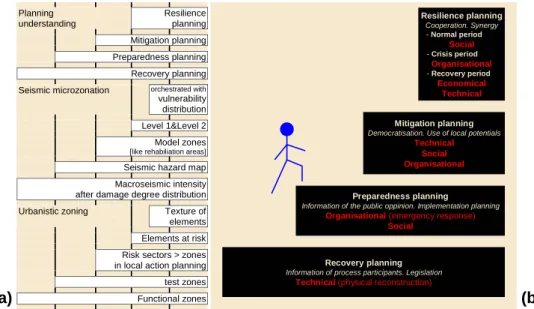
Technical Social Organisational Resilience planning Cooperation. Synergy - Normal period Social - Crisis period Organisational - Recovery period Economical Technical Planning understanding Resilience planning Mitigation planning Preparedness planning Recovery planning Seismic microzonation orchestrated with vulnerability distribution Level 1&Level 2 Model zones
[like rehabiliation areas] Seismic hazard map Macroseismic intensity after damage degree distribution Urbanistic zoning Texture of elements Elements at risk Risk sectors > zones in local action planning
test zones
Functional zones
(a)
(b)
Fig. 4. Types of planning understanding: (a) their relationship to seismic microzonation and urban zoning; (b) time steps and layers.
the 20th century gives insights into the ”long term nature of earthquake protection from the decisions implemented in the aftermath” (Coburn and Spence, 2002):
– early: Pakistan, after the 1935 earthquake (Coburn and
Spence, 2002),
– mid: Skopje after the 1963 earthquake (Greene, 1987), – late: Mexico-City after the 1985 earthquake (Coburn
and Spence, 2002).
For Bucharest no such examples are known. 3.1.2 Preparedness planning
Emergency preparedness planning is useful for officials, not necessarily experts. Legal frame is in Romania the Gov-ernment Ordinance “Protection against disasters“ (Daraban, 2000). HAZUS (FEMA, 1999) is a well-known US com-puter aided modular methodology for loss estimation and emergency preparedness planning. Parameters on the po-tential earthquake, the built substance, and the infrastructure are used to compute scenario physical damage and socio-economic losses. Secondary events, like fire threat, are included. Central is the capacity spectrum analysis: the performance point, intersection of the ground motion de-mand spectrum (spectral acceleration versus displacement), and of the structure under lateral load capacity spectrum (pushover curve), is determined, building the input for “fragility curves“: the future building type proportion in each damage state. Area parameters (ex. land-use) are trans-formed into building parameters and individual data of build-ings are mapped to areas. Obtained databases are loss esti-mates for zones, not for building classes.
Computer tools can aid local decision makers in post-earthquake disaster staff. Fiedrich (2004) proposed the in-tegrative model EQ-RESQUE to support the prioritisation of
intervention zones and the efficient allocation of help-and-rescue resources through action proposals. A distributed sim-ulation system connects its two interacting components:
1. simulation of the dynamic disaster environment and of the work of resources;
2. decision process modelling using software agents math-ematically optimised with expert knowledge concerning the multiple tasks and the communication structures and decision competences within the disaster staff.
Recent developments include a “Disaster management tool“ (Markus et al., 2004), for damage and casualty estimation and detection as well as communication and information sup-port for the disaster management staff. This tool for pre-event training and post-pre-event disaster management was tested in an exercise by the civil protection. It also integrates a com-puter aided damage estimation tool: EQSIM.
3.1.3 Mitigation planning
Mitigation planning serves urban earthquake risk manage-ment. Collaboration between the involved actors is required to reduce global hazard impact. In the 2003 Earthquake Mas-ter Plan of Istanbul, risk mitigation measures coordination is achieved, as actors in each ”risk-sector” (”sets of causal rela-tions focused on specific urban risks or vulnerabilities”) are activated through the ”contingency-plan” that integrates all ”risk-sectors” (Balamir, 2004). For each ”risk-sector”, the nature, problems, management methods, actors, and action proposals are outlined (ex. the scope of ”risks in urban tex-ture” includes the determination of risks in the ”differential formation of urban fabric”, Balamir, 2004). Zoning concerns open space scarcity or incompatible use risks (mitigation: finer land-use zoning). To the ”risk-sectors” project packages within both the ”contingency-plan” and local action plans correspond. Lines of action are proposed: to involve local
402 M. Bostenaru Dan: Multidisciplinary co-operation according to urbanistic zoning and seismic microzonation actors, incl. community, in the urban risk management, to
draw agreements and to run sub-project packages (Balamir, 2004). Foreseen ”model-zones” represent policy implemen-tation preferences, according to the problems and potentials of the respective area (Balamir, 2004):
– extensive development areas,
– intensive development in seismically safe areas, – areas endangered by secondary events,
– historical-culturally significant areas,
– rehabilitation areas, highly vulnerable due to seismic or
building stock properties, requiring public declaration of their microzonation maps in local action planning. All planning measures in urban earthquake risk management go from the historical built substance. In the structuring phases of the urban development process, actors from the passive publicity sphere, experts and active affected people are involved. They act within different reference systems, un-der dynamic, sometimes opposite, conditions. The concept of “retrofit-elements“, developed to account for the interde-pendencies between the constructive, functional and aesthet-ical characteristics of a building, and a chosen retrofit strat-egy (Bostenaru, 2004c), proved suitable to serve the organi-sational and operational structure in model projects within a strategy, to implement retrofit measures in urban areas. The strategic planning approach in Bostenaru (2004c) focused on planning management in the field of experts, with a detailed view on the decision space between scopes, means, function and costs. The “retrofit-elements“ build a common denomi-nator for the points of view of all actors participating in the decision process.
3.1.4 Resilience planning
Resilience planning aims sustainable urban risk mitigation. The concept of building disaster resilient communities gains acceptance and has already found way into training, in urban risk reduction courses: community based disaster mitigation (Delica and Arambepola, 20002), or ”Housing and earth-quakes” (Gülersoy and Özsoy, 2001). Methods in develop-ment, addressing the complex dimensions of resilience, are exemplified in the research started by Bruneau et al. (2003) and the RISK-UE project (Mouroux et al., 2004).
Bruneau et al. (2003) provided a conceptual framework for the resilience of communities to earthquake risk: resilience is measured qualitatively in the reduction of failures and their consequences, and of recovery time. The resilience proper-ties are measured by Bruneau et al. (2003) quantitatively as ”ends” (system robustness, reaction rapidity) to be reached by ”means” (resourcefulness, redundancy of elements/sub-systems). Community resilience displays technical, organ-isational, social and economic dimensions (Bruneau et al.,
2Delica, Z, Arambepola, NMSI: Workshop on urban
disas-ter mitigation, Karlsruhe University, Germany, course madisas-terial, Asian Disaster Preparedness Center, Bangkok, Thailand, http:// www.adpc.ait.ac.th, 2000.
2003). The development and application of quantitative mea-sures in a case study of the Memphis, Tennessee, water deliv-ery system (Chang and Shinozuka, 2004) proved the Bruneau et al. (2003) resilience framework, employed to analytically determine the resilience of different units, as a valuable guid-ance for mitigation and preparedness.
The RISK-UE project developed a modular methodology for earthquake scenario assessment through global impact analysis, accounting for the distinctive features of European cities with regard to current and historical buildings, as well as their functional and social organisation. The project was organised in work packages, for either methodologies, or the application to the participating cities: Barcelona, Bitola, Bucharest, Catania, Nice, Sofia, Thessalonica. Seismic zona-tion was addressed in a work package concerning probabilis-tic and determinisprobabilis-tic earthquake hazard evaluation (Faccioli and Pessina, 2003). Urbanistic zoning was addressed in the work package ”Urban System Analysis” (Masure and Lut-off, 2003) through the ”Urban-System-Exposure” method-ology: system components and their functionality, then the “elements-at-risk“, their indicator-quantified exposure, and the vulnerability factors were analysed, leading to the identi-fication of problems and opportunities. The spatial distribu-tion of strategic or vulnerable elements was mapped. The el-ements were ranked according to their role in the system dur-ing normal, crisis and recovery periods. After appropriation of the problems posed by seismic risk, “management-plans“ and “plans-of-action“ are proposed for strategic implementa-tion by decision-makers through land-use decisions. 3.2 Interdependencies between planning layers
Morphologically the “urban-frame“ is composed out of the following sub-frames:
– physical:
– natural environment, linked to natural hazards, – built environment, linked to vulnerability; – economic;
– psycho-social;
– juridical-administrative, linked to the preparedness
planning and legislation;
– historical-cultural, linked to the historic selectivity of
the textures in restructuration.
Since the transformation generator is the “life-way“ and not the “-frame“, only changes in activities can result into risk mitigation. Behaviour changes need inhabitants’ support. The more accentuated the voluntary character in the restruc-turation process, the role of experts, of decision makers, and of public opinion grows. Bostenaru (2004d) explored the contribution of participatism to disaster mitigation, when this concerns earthquake impact on urban settlements, through the support provided to multi-criteria decision in retrofit. Models paying consideration to the co-operation among dif-ferent actors implied in the planning process were selected
M. Bostenaru Dan: Multidisciplinary co-operation according to urbanistic zoning and seismic microzonation 403 for analysis. In a historic perspective spanning half a
cen-tury, two generations of inhabitants’ implication in politics-democratisation-urbanism became evident: participation and its successor, communication. The participation is based on a central decision process leading to a solution controlled and steered by the political-administrative system. The com-munication is characterised by simultaneous decisions taken by politics and administration in co-operative procedures (Bostenaru, 2004d). In all investigated cases it could be talked of successful learning and of the improvements in the professional debate. The historically investigated stages can be remet in a single contemporary approach, the “Interna-tionale Bauausstellung Emscher Park“ (IBA, 1999), proving that the transition stages from participation to communica-tion are layers in any democratic planning.
Layers can be distinguished in disaster management plan-ning, too: recovery, preparedness, mitigation and resilience (Fig. 4b). Various steps were constituted along time:
– Skopje, Macedonia (FYR):
– Re-shaping recovery planning after the 1963
earth-quake (Greene, 1987),
– mitigation planning in the earthquake Master Plan
2001–2020 (Savic, 2001);
– Bursa, Turkey:
– historical recovery planning after the 1855
earth-quake (Coburn and Spence, 2002),
– mitigation planning today (Bademli, 2001).
Central to recovery planning stays the technical dimension: physical reconstruction. In preparedness planning the emer-gency response ability of organisation, and herewith the or-ganisational dimension stay in foreground. Decision be-ing an element in the risk management process, both the processural and the social dimension of risk management are considered on decision level. In mitigation planning, natural (technical dimension) and human (social dimen-sion) factors are considered in the framework of ex. “risk-sectors“. The social dimension is highlighted through the democratic involvement of the whole society in risk man-agement. Along the organisational dimension, the ner has a moderator-role, in a new understanding of plan-ning. In the “Urban-System-Exposure“ methodology dif-ferent “homogenous-units“ (zones) within the investigated city can be comparatively related on the denominator of “elements-at-risk“. The problems and opportunities, as well as the elements’ vulnerability, lead to system resilience: physical, human, functional, economic and social. In nor-mal period the classification of the “elements-at-risk“ serves priority setting for pre-earthquake retrofit actions. Appropri-ation phases, within a local participative framework, of the problem posed by seismic risk, highlight the social dimen-sion. In crisis periods, there is an organisational demand for emergency systems. In recovery periods economic resources are needed. Attention should be paid for ”turning recon-struction into future protection” (Coburn and Spence, 2002),
where the technical dimension counts. Both mitigation and resilience planning show similarities to the layer corrobora-tion in the IBA Emscher Park (1999): accorrobora-tion planning pro-cesses are expected to be initiated by means pilot projects. Methods and tools developed in model projects will find fu-ture way in urban practice.
4 Results
Research on how to facilitate actors’ collaboration (Boste-naru, 2004e) considered the timing in actors’ preferences on intervention layers in urban seismic rehabilitation: town, building and element. Orientation means for actors’ interac-tion, like the “retrofit-elements“ in buildings, were designed on each level. The implementation of the decision model was exemplified in a strategic plan for an urban intervention towards the reduction of earthquake hazard impact. The pro-posed risk management in urban textures presents similari-ties to the mitigation planning example discussed in this con-tribution: urban texture zones differentiated in the plans are sustained through long-term physical policies for redevelop-ment, like differential property taxation.
Urban earthquake impact results from the interaction of three complex systems:
1. the earth system, consisting of
(a) regional geologic factors: seismic source and seis-mic wave propagation;
(b) geometric-physical local geology conditions, ac-counted for in seismic microzonation;
Using geological, geophysical and geotechnical data, as well as source and propagation models, pre-event seis-mic seis-microzonation can be performed and extrapolated in time and location. Seismic records are a quantitative basis for urban planning and building design.
2. the social, economic and political system from normal, as opposed to crisis and recovery, periods, accounted for in building codes and disaster regulations;
3. the anthropised system (buildings and infrastructure), accounted by vulnerability studies, incl. specific mate-rials and technologies, and seismic planning.
4.1 The role of zoning in the geophysical system
Seismic building damage depends on the ground mo-tion (amplitude, frequency, shaking duramo-tion) and the building structure (resonance period related to subsoil local transfer) characteristics. For engineering stud-ies, the spectra and accelerograms express best the seis-mic site response. Displacement spectra model earth-quake actions on buildings: the displacement dimension correlates to damage and the period dimension to the relationship ground-motion-frequency-content/fundamental-vibration-period-of-the-building (Fig. 5a). The destruction amount in Bucharest was attributed mainly to the so-called
404 M. Bostenaru Dan: Multidisciplinary co-operation according to urbanistic zoning and seismic microzonation 8 M. Bostenaru: Multidisciplinary cooperation in building design according to urbanistic zoning and seismic microzonation
democratic involvement of the whole society in risk man-agement. Along the organisational dimension, the ner has a moderator-role, in a new understanding of plan-ning. In the ’Urban-System-Exposure’ methodology dif-ferent ’homogenous-units’ (zones) within the investigated city can be comparatively related on the denominator of ’elements-at-risk’. The problems and opportunities, as well as the elements’ vulnerability, lead to system resilience: physical, human, functional, economic and social. In nor-mal period the classification of the ’elements-at-risk’ serves priority setting for pre-earthquake retrofit actions. Appropri-ation phases, within a local participative framework, of the problem posed by seismic risk, highlight the social dimen-sion. In crisis periods, there is an organisational demand for emergency systems. In recovery periods economic resources are needed. Attention should be paid for ”turning recon-struction into future protection” (Coburn and Spence, 2002), where the technical dimension counts. Both mitigation and resilience planning show similarities to the layer corrobora-tion in the IBA Emscher Park (1999): accorrobora-tion planning pro-cesses are expected to be initiated by means pilot projects. Methods and tools developed in model projects will find fu-ture way in urban practice.
4 Results
Research on how to facilitate actors’ collaboration (Boste-naru, 2004e) considered the timing in actors’ preferences on intervention layers in urban seismic rehabilitation: town, building and element. Orientation means for actors’ interac-tion, like the ‘retrofit-elements’ in buildings, were designed on each level. The implementation of the decision model was exemplified in a strategic plan for an urban intervention towards the reduction of earthquake hazard impact. The pro-posed risk management in urban textures presents similari-ties to the mitigation planning example discussed in this con-tribution: urban texture zones differentiated in the plans are sustained through long-term physical policies for redevelop-ment, like differential property taxation.
Urban earthquake impact results from the interaction of three complex systems:
1. the earth system, consisting of
(a) regional geologic factors: seismic source and seis-mic wave propagation;
(b) geometric-physical local geology conditions, ac-counted for in seismic microzonation;
Using geological, geophysical and geotechnical data, as well as source and propagation models, pre-event seis-mic seis-microzonation can be performed and extrapolated in time and location. Seismic records are a quantitative basis for urban planning and building design.
2. the social, economic and political system from normal, as opposed to crisis and recovery, periods, accounted for in building codes and disaster regulations;
(b) -3 -2 -2 -1 -1 0 1 1 2 2 3 0 2 4 6 8 10 12 14 16 0,00 0,20 0,40 0,60 0,00 1,00 2,00 3,00 4,00 Period [s] D is p la c e m e n t [m ] longitudinal transversal Displacement -0,3 -0,2 -0,1 0,1 0,2 0 2 4 6 8 10 12 14 16 Time (s) m (a)
Fig. 5. (a) Displacement seismogram (top) and spectra (bottom); (b) Accelerogram of the 1977 Vrancea-earthquake (using parame-ters from Ambraseys et al. (2002)
3. the anthropised system (buildings and infrastructure), accounted by vulnerability studies, incl. specific ma-terials and technologies, and seismic planning.
4.1 The role of zoning in the geophysical system
Seismic building damage depends on the ground mo-tion (amplitude, frequency, shaking duramo-tion) and the building structure (resonance period related to subsoil local transfer) characteristics. For engineering stud-ies, the spectra and accelerograms express best the seis-mic site response. Displacement spectra model earth-quake actions on buildings: the displacement dimension correlates to damage and the period dimension to the relationship ground-motion-frequency-content/fundamental-vibration-period-of-the-building (Fig. 5a). The destruction amount in Bucharest was attributed mainly to the so-called ’Mexico-city’ effect on alluvial soil deposits. This layer
am-Fig. 5. (a) Displacement seismogram (top) and spectra (bottom); (b) Accelerogram of the 1977 Vrancea-earthquake (using parame-ters from Ambraseys et al. (2002)).
“Mexico-city“ effect on alluvial soil deposits. This layer am-plified the seismic site response in the period range critical for the pre-damaged interwar buildings (Lungu et al., 1994), with structures designed for gravitational loads only, altered unfavourably to later function changes. The first system-atic measurements of ambient seismic noise in the centre of Bucharest concluded that damage degree in the 1977 earth-quake increased with the fundamental period of the structure (Sandi and Perlea, 1982). Bonjer et al. (1999) obtained in a site response experiment local soil resonances of 1–2 s (peaks
∼1.4 s). Flexible 6–12-storey reinforced concrete buildings are expected to shift their fundamental resonance towards the strongest site resonance (Ambraseys, 1977), especially in weakened pre-damaged structures (cracked period). The fun-damental period of the flexible Modernism skeleton structure buildings was 0.7–1.6 s, a range which corresponds to the spectral maximum (Fig. 5a) obtained for the only reliable ac-celerogram recorded in Bucharest during the 1977 Vrancea-earthquake (Fig. 5b), while rigid load-bearing structures with
masonry walls or reinforced concrete structural walls with 0.2–0.7 s fundamental period (Moldoveanu et al., 2004) were lightly damaged.
The foundation ground in Bucharest is classified in (Moldoveanu et al., 2004):
– alluvial-proluvial deposits (Cotroceni-V˘ac˘are¸sti plain,
Dâmbovi¸ta-Colentina interstream);
– diluvial deposits (Dâmbovi¸ta terraces);
– alluvial deposits (Dâmbovi¸ta and Colentina meadows); – artificial fills (Dâmbovi¸ta-Colentina interstream).
The hydrostatic level varies from 1–5 m in the meadows to bellow 10 m in the plains. Soil-structure interaction is impor-tant also for the problematic foundations of these buildings (Bostenaru, 2004a).
The architectonic landmarks of Modernism in Romania, located on unfavourable sites according to seismic micro-zonation, would perform bellow satisfactory in an earthquake with similar spectral content to the 1977 one. Therefore, Mândrescu and Radulian (1999) see they key for understand-ing earthquake patterns in comparunderstand-ing vulnerability tion maps with seismic microzonation and damage distribu-tion maps.
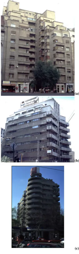
Rules for seismic design were first introduced in Romania after awareness raised by the damage in the 1940 earthquake. A practicing engineer, leading one of the enterprises which implemented innovative structural and construction manage-ment solutions for this building type, documanage-ments (Prager, 1979) successful engineer-architect collaboration during the boom-time of constructing in Avantgarde style (Bostenaru, 2004a). Although interrupted during the economic crisis, this was both incentive and opportunity raiser for creative design and technical solutions in constructing with a material new that time. This co-operation made many reinforced concrete building initiatives possible. Far from adopting the simplest ideal conformation, usability and aesthetics strongly influ-enced the structural solution. An array of success stories is documented in Fig. 6 and Table 1.
4.2 The role of zoning in the social system
Morphologically, the spatio-perceptive elements of the “urban-frame“ transpose in the urban territory the activity system. Each decision and each action is transposed mate-rially in space occupation. Bucharest saw 1920–1940, in two decades of intense building efforts, the construction of the buildings which give its face of today, many of them designed by world-class architects. It was a unique time when not the aesthetics governed, but a solution to the problems of the so-ciety: the lack of housing suiting the life style. Urban leg-islation reacted with the 1934 Master Plan to the anticipated impact of economic development in interwar Romania on ur-ban areas. The land-use occupancy ratio was prescribed for the central zone. Numerous multifunctional (housing, office, shops, cinemas) complexes were constructed making maxi-mum land-use, allowed only with 30% of the total admitted building volume at ground level. The multiple usage of the
M. Bostenaru Dan: Multidisciplinary co-operation according to urbanistic zoning and seismic microzonation 405 space through building in the height in urban agglomerations
is a concretisation form of the “fight-for-space“ of “urban-forces“ (Sandu, 1995b) in opposition. The properties of the urban space result from the interaction of social groups mod-elling it. Bucharest’s central luxurious residences illustrate how a move of interests of the social groups in the urban ter-ritory has a parcours, which it follows till finding place.
The centre is a special case of the character-of-a-zone. A texture completes spatially another texture when, through or-ganised superposition, they generate mixed assemblies with complex character. In subdivisions of the central area either residential/central functions dominate or dominant residence co-operates with central functions. On the N-S boulevard in Bucharest a spatial co-operative superposition of urban tex-tures with complementary character contributes to a specific zonal ambient. The commercial, cultural, administrative, and residential space complexity expresses a necessity. The affer-ent space is conditioned through its occupation reported to the “life-way“, with its socio-economic development and the natural environment conditions in the context of a continuous intervention process in time. Retrofit methods innovative in international context were proposed after the 1977 Vrancea-earthquake (Sandi et al., 1982), but remained on paper until in the frame of co-operations within the field of earthquake engineering attention was raised to the conservation of ex-isting buildings, to complement the development of seismic codes for new buildings. Daraban (2000) dealt with method-ological and legislative guidelines in the rehabilitation of the existing building stock in Romania (Table 2). The contempo-rary approach follows strategic means. Instead of the whole city, intensive zones were identified, and for these detailed implementation solutions are elaborated through demonstra-tive projects. These “test-zones“ have different size in the corresponding projects (SFB 461, Wenzel, 1997 and RISK-UE, Mouroux, et al. 2004) and were chosen according to the damage occurrence documented in the 1977 earthquake. Interests like building for speculation met the ”exigency” (”the enounce of a user necessity regarding the construction”, Daraban, 2000) for safety in residential buildings, the legisla-tive ”resistance and stability” requirement. Today a “user-exigency“ motivates for urban renovation, if the performance level is below new user requirements (Daraban, 2000). 4.3 The role of zoning in the urbanistic system
In resilience planning, consideration for the morphological town elements, “urban-life“ and “urban-frame“, and the role of the town in a wider urban area can be recognised. The earthquake vulnerability of the system is evaluated through an analysis of the system functionality. A system is defined analytically through its elements and their relationships. The role of the elements in the system differs, according to their “urban-frame“ value (perceptional aspects like the city im-age and identity), and their role in the “urban-life“ (activities in the town or the function of the town in context). In an integrated seismic risk study, the city is seen an open sys-tem, connected with its environment, and approached as an
M. Bostenaru: Multidisciplinary cooperation in building design according to urbanistic zoning and seismic microzonation 9
(d) (c)
(a) (b)
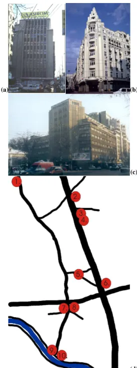
Fig. 6. Examples of buildings designed in successful co-operation
between engineers and architects, which proved to have earthquake resilient features despite their high irregularity, resulted from re-specting the urban zoning rather than site conditions: (a) Casa Mag-istra¸tilor, (b) ‘Union’ hotel, (c) ARO-building (today ’Patria’); (d) Location of the examples in Table 1: 1. CAM-building; 2. The magistrates house; 3. ARO-building; 4. ’Ambassador’ hotel; 5. ‘Union’ hotel; 6. ‘Dalles’ foundation; 7. Block-of-flats on Calea Victoriei 23; 8. of-flats on Calea Victoriei 68/70; 9. Block-of-flats at the Calea Victoriei/Splaiul Independen¸tei crossing; 10. Block-of-flats on Splaiul Independen¸tei.
plified the seismic site response in the period range critical for the pre-damaged interwar buildings (Lungu et al., 1994), with structures designed for gravitational loads only, altered unfavourably to later function changes. The first system-atic measurements of ambient seismic noise in the centre of Bucharest concluded that damage degree in the 1977 earth-quake increased with the fundamental period of the structure (Sandi and Perlea, 1982). Bonjer et al. (1999) obtained in a site response experiment local soil resonances of 1-2s (peaks
∼1.4s). Flexible 6–12-storey reinforced concrete buildings
are expected to shift their fundamental resonance towards the strongest site resonance (Ambraseys, 1977), especially in weakened pre-damaged structures (cracked period). The fundamental period of the flexible Modernism skeleton struc-ture buildings was 0.7-1.6s, a range which corresponds to the spectral maximum (Fig. 5a) obtained for the only reliable ac-celerogram recorded in Bucharest during the 1977 Vrancea-earthquake (Fig. 5b), while rigid load-bearing structures with masonry walls or reinforced concrete structural walls with 0.2-0.7s fundamental period (Moldoveanu et al., 2004) were lightly damaged.
The foundation ground in Bucharest is classified in (Moldoveanu et al., 2004):
– alluvial-proluvial deposits (Cotroceni-V˘ac˘are¸sti plain,
Dâmbovi¸ta-Colentina interstream);
– diluvial deposits (Dâmbovi¸ta terraces);
– alluvial deposits (Dâmbovi¸ta and Colentina meadows); – artificial fills (Dâmbovi¸ta-Colentina interstream).
The hydrostatic level varies from 1-5m in the meadows to bellow 10m in the plains. Soil-structure interaction is impor-tant also for the problematic foundations of these buildings (Bostenaru, 2004a).
The architectonic landmarks of Modernism in Romania, located on unfavourable sites according to seismic micro-zonation, would perform bellow satisfactory in an earthquake with similar spectral content to the 1977 one. Therefore, Mândrescu and Radulian (1999) see they key for understand-ing earthquake patterns in comparunderstand-ing vulnerability tion maps with seismic microzonation and damage distribu-tion maps.
Rules for seismic design were first introduced in Romania after awareness raised by the damage in the 1940 earthquake. A practicing engineer, leading one of the enterprises which implemented innovative structural and construction manage-ment solutions for this building type, documanage-ments (Prager, 1979) successful engineer-architect collaboration during the boom-time of constructing in Avantgarde style (Bostenaru, 2004a). Although interrupted during the economic crisis, this was both incentive and opportunity raiser for creative design and technical solutions in constructing with a material new that time. This co-operation made many reinforced concrete building initiatives possible. Far from adopting the simplest ideal conformation, usability and aesthetics strongly influ-enced the structural solution. An array of success stories is documented in Fig. 6 and Table 1.
Fig. 6. Examples of buildings designed in successful co-operation between engineers and architects, which proved to have earthquake resilient features despite their high irregularity, resulted from re-specting the urban zoning rather than site conditions: (a) Casa Mag-istra¸tilor, (b) “Union“ hotel, (c) ARO-building (today “Patria“); (d) Location of the examples in Table 1: 1. CAM-building; 2. The magistrates house; 3. ARO-building; 4. “Ambassador“ hotel; 5. “Union“ hotel; 6. “Dalles“ foundation; 7. Block-of-flats on Calea Victoriei 23; 8. of-flats on Calea Victoriei 68/70; 9. Block-of-flats at the Calea Victoriei/Splaiul Independen¸tei crossing; 10. Block-of-flats on Splaiul Independen¸tei.
integrated part of the seismic risk scenario. Seven RISK-UE components mix the morphological, functional and dynamic
406 M. Bostenaru Dan: Multidisciplinary co-operation according to urbanistic zoning and seismic microzonation
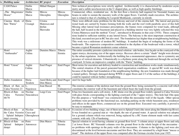
Table 1. Examples of successful reinforced concrete (RC) building design on difficult site conditions (details from Prager (1979)).
No. Building name Architecture RC project Execution Description
1 CAM Palace Duiliu Marcu
Mihail Hangan New technical prescriptions were strictly applied. Architecturally it is characterised by modernist asym-metry and a subtle neoclassicism in the U-shaped plan, as well as high quality finishings.
2 „The Magistrates‘ House“ Duiliu Marcu Mircea Gheorghiu Mircea Gheorghiu
Commercial, office, residential use. At the first floor a festivity hall required for Vierendel frames and beams in order to sustain the masonry walls of the upper floors. Carefully made execution. The architec-ture is related to that of a building by Leopold Medilanski, currently in retrofit.
3 Cinema block of flats ”Patria” Horia Creang˘a Cristea Mateescu and ¸Stefan Mavrodin
There were difficult static problems for the balcony and roof of the cinema hall. The lateral and gravita-tional loads are carried by frames forming both the walls and the roof (with parabolic arcs) of this hall. Missing other lateral load resistance prescriptions, the frames were computed for wind loads, although the hall, half located in the basement and placed in a building interior was very lightly solicited this way. Cristea Mateescu used the method ”Cross”, introduced in Romania in that year (1934). These computa-tions leaded to sufficient stability at any lateral forces. The balcony is the most important construction of this kind, executed not just in RC but also steel. The foundation lays higher than at neighbouring buildings. This work was a milestone of modern RC buildings. It marked the begin of reshaping the forms of the boulevards. The expressive composition contributed to the rhythm of the boulevard with a tower, which became a typical Romanian modernist corner solution.
4 Hotel ”Ambasador”
Arghir Culina
Dumitru Marcu Tiberiu Eremia
The entire assembly presents a judicious structural solution: side bodies, free façade on the courtyard of the upper storeys, decreasing size of the upper storeys. Recesses above a certain ”shade”-height were dictated by the urban regulation. Architecturally the building has a monumental appearance, due to symmetry and presence of vertical elements. Urbanistically is a rhythmic point along the boulevard through the set-back courtyard. It forms an impressive complex with the “Patria“ building.
5 Hotel ”Union” Arghir Culina
Emil Prager Emil Prager Short terms for execution and delivery leaded to construction and installation works made simultaneously. The central situation of the parcel generated hard organisation conditions. A special RC work was done because of the higher laid foundation of the neighbouring building: the new foundation was made through a tunnel gallery. Strongly damaged during WWII (4 upper floors and 2/3 of the surface of the building), it could be repaired without further strengthening.
6 Dalles foundation Horia Teodoru
Aurel Bele¸s and Dim Marcu
Emil Prager steel for huge halls 7 Block of flats on Calea Victoriei 23 L. Negoiescu Jean Hascal M. Calmanovici
The exterior columns of the skeleton start from the ground floor, being sustained by a concrete wall which constitutes the exterior wall of the basement and which bears the loads from the ground.
8 Block-of-flats on Calea Victoriei 68/70
Nicolae Nenciulescu
Luigi Cora Emil Prager It has two basements and a soft storey. A RC dome over the ground floor widely opened to Calea Victoriei with glass bricks corresponding to the lighting courtyard of the 7 upper storeys. This hole had 10m span. For this purpose a “wall-beam“ was constructed within the mezzanine wall of the façade. Other special problems were provided by the functional use, including parking on the whole basement area, residences and offices in the upper floors, commercial use on the ground floor. Executed very carefully, it proved to be easy to maintain.
9 Block-of-flats at the Calea Victoriei – Splaiul Indepen-de¸tei crossing
Nicolae Cucu and Gheorghescu
Mihail Hangan Jean Hascal It consists of two building wings, one of them next to Splaiul Unirii (the street along the Dâmbovi¸ta River). It was founded on a general mat at ∼6m depth, the one of ground water. A special solution was adopted for a ground column which was removed, being replaced by a RC frame element made with fast casted cement, with only 12h of hardening.
10 Block-of-flats on Splaiul Indepen-den¸tei
Petre Antonescu
Dim Marcu Tiberiu Eremia
Special solution to avoid having columns at ground floor level: 3 column arrays at upper floors and only 2 at lower floors: RC Vierendel columns over the ground floor in the whole height of the mezzanine – no problems with openings in the party walls of the mezzanine. Columns to the lighting yard were also discontinued at the level between mezzanine and first floor. They are sustained by a high beam ”macaz cu tirant”. The skeleton of the upper floors was computed after the German circular from year 1925.
town elements. The “multi-task operation [of resilience plan-ning] requires the integration of programs prepared in dis-tinct areas and aims to generate a lasting synergy based on coordination” (Balamir, 2004). Urban zoning confirms the integration as vital necessity in the existence of the urban or-ganism. Functional integration occurs at the level of:
– object functions: analysis of a functions complex to
which the built substance responds,
– urban functions and programmes.
Sandu (1997) affirms that ”out of all urban spaces, the street is available as the most adequate location for the affirmation of the urban character.” The urban frame of a street is de-fined by its floor, background and fronts (Fig. 2a). Analyt-ically, the analysis of this frame begins with that of its pro-files and parcours (Fig. 2). The spatial manifestation of the street results from a combination of factors: functionality, climate and terrain conditions, historic existence, conceptual design and last but not least “life-way“ (Sandu, 1995b). In the Master Plan of Bucharest, as the Charter of Athens 1933 (CIAM, 1946) stipulated circulation as functional zone, the street remained a formal expression of functionality. Another essential element of the Master Plan of Bucharest was the cir-culation network. Circir-culation control was expressed in the
shape of street fronts, for which concepts of style were in-cluded (Machedon and Scoffham, 1999). For the centre, the cornice height limit was fixed, except at corners, leading to set-back upper floors. The inversing of the positive and neg-ative space, placing constructed volumes “in-the-green“ was not undertaken.
Restructuring urban actions are reordering efforts of the el-ements into textures, aimed at the functionality of the “urban-structure“. After the 1977-earthquake a number of dam-aged buildings were repaired and strengthened, while those collapsed were replaced in multi-disciplinary cooperation. For changes imposed by the partial collapse of some build-ings acceptable architectural solutions in retrofitting were found, and solutions which might seem economically inef-ficient were adopted in order to preserve as much as pos-sible from these historical-architecturally relevant buildings (Fig. 7), since the completion of the N-S Boulevard fronts leaded to ”an architectural sequence of modernist buildings (...) without equal in Europe” (Machedon and Scoffham, 1999). In Table 3 the impact of an urban restructuration pro-posal for a street is studied. The vulnerability of a street affects its resilience in all four dimensions. The N-S main boulevard in Bucharest is characterised by typological unity.
M. Bostenaru Dan: Multidisciplinary co-operation according to urbanistic zoning and seismic microzonation 407
Table 2. Correspondence of qualitative exigencies to derived provisions for urban planning, using Daraban (2000) and MLPAT (1994).
Type Year Content Urbanism exigencies
national standard
1972 Design principles for constructions in earth-quake prone areas
- proper choice of the site,
- rational conformation of the assembly, mass and volume distribution, - corresponding materials,
- economically feasible seismic measures, 1988 Foundation terrain classification and
identifi-cation
- in geologically instable regions, respect of microzonation maps/studies, - no foundation on inadequate terrains.
1971 The seismic intensity scale none 2000 Proof principles of constructions security: at
functional, natural, climatic, seismic and ex-ceptional causes
none
1991-1993
Seismic zoning and the microzonation of the territory of Romania
none
government decision
1990 The reduction of damage risk in constructions affected by earthquakes
the obligation to perform geotechnical studies on parcels next to buildings, accounting for the type and the importance of constructions and of the designed construction system
1991 Strengthening measures on earthquake dam-aged buildings
keeping an inventory of damages regarding the resistance and stability of constructions on geographical zones and local sites
1994 Regulation regarding the establishment of the importance category of the construction
importance categories and classes influence the justification in the site choice government
ordinance
1994 Protection against disasters none
law no. 10 1995 The quality in constructions 1. ”geotechnical mappings and hydrologic and geologic analyses”: the quality of the urban site, the imposed general founding conditions, the determined height of ground water. The impossibility to construct or furnish in zones exposed to natural risk is considered. Only interventions limiting negative effects can be admitted. 2 “expertise of the building stock targeting the evidence of its characteristics and uses”: the constructive system of the buildings, the maintenance state and age (buildings pre-damaged by earthquakes, physical wearing), volumetric configuration, height, distances between the buildings.
Romanian seismic code
1992 P 100-92 - choice of sites with favourable seismic behaviour,
- conformation of assemblies, correlated to structural implementation, for a good seismic behaviour, - choice of the site to respect the economic component,
- height stated according to functional and urbanistic consideration, - installations and equipments included from design on in seismic categories,
- for buildings the damage of which has particularly severe consequences, the categories of excluded sites will be précised from begin, naturally difficult sites have to be optimised through specific measures, if not avoided.
Residential buildings feature the same structural type of rein-forced concrete skeleton. Due to their Modernist style, they belong to a common architectural typology. This building class considered displays a socio-architectural type with a certain typology of the housing unit developed that time. Fi-nally there are common characteristics of the type concern-ing the ownership pattern and eventual economic strategies resulting therefrom.
5 Perspectives
Physical vulnerability is well assessed by displacement spec-tra. Therefore their shapes need a further study. Organisa-tional and social vulnerability cannot be assessed with help of displacement spectra. Economic vulnerability can only be limitedly assessed this way, as it can be taken into account by scaled curves for the yield and post-yield periods, which stay for moderate and strong damages respectively.
Predictive approaches to urban risk management can be classified as:
1. Seismic hazard and engineering vulnerability assess-ment (seismic properties of sets of individual buildings are investigated and recommendations for retrofitting made according to technical and economic criteria):
– Qualitative methods: field investigation by experts,
ex. Rapid Visual Screening (ATC-21, 1988), result-ing in applications like HAZUS (FEMA, 1999).
– Quantitative methods: seismic damage potential
as-sessment derived from structural analysis, exempli-fied by Glaister and Pinho (2003).
2. Urban system vulnerability analysis (human, material and financial loss models based on physical damage sce-narios), leading to technical measures to be taken by authorities through planning instruments. The RISK-UE ”Urban-System-Exposure” analysis completes this practice with immaterial town morphology elements. Glaister and Pinho (2003) proposed, alternatively to the ca-pacity spectrum analysis, a simplified deformation-based ur-ban vulnerability assessment methodology. Qualitative dam-age limit states are expressed using analytic relations be-tween building displacement capacity and height. Empir-ical elastic-period/equivalent-height relationships translate the deformation capacity curves from height to period di-mension. Demand curves are damped displacement response spectra. The intersection of the capacity and demand curves delimits building height classes failing limit states. An ap-proximate joint probability density function completes the obtained cumulative distribution, accounting for the uncer-tainty in the geometrical, material and limit-state building class properties (Crowley et al., 2004).
While in recovery, preparedness, or mitigation planning, a sub-area wide division is useful, the method started by Glaister and Pinho (2003) is one of the few approaches where a typological classification is used. Also the RISK-UE “elements-at-risk“ (Masure and Lutoff, 2003) are clas-sified strategically, showing similarities to the approach of