HAL Id: hal-00301066
https://hal.archives-ouvertes.fr/hal-00301066
Submitted on 16 Mar 2006HAL is a multi-disciplinary open access
archive for the deposit and dissemination of sci-entific research documents, whether they are pub-lished or not. The documents may come from teaching and research institutions in France or abroad, or from public or private research centers.
L’archive ouverte pluridisciplinaire HAL, est destinée au dépôt et à la diffusion de documents scientifiques de niveau recherche, publiés ou non, émanant des établissements d’enseignement et de recherche français ou étrangers, des laboratoires publics ou privés.
Integrated systems for forecasting urban meteorology,
air pollution and population exposure
A. Baklanov, O. Hänninen, L. H. Slørdal, J. Kukkonen, N. Bjergene, B. Fay,
S. Finardi, S. C. Hoe, M. Jantunen, A. Karppinen, et al.
To cite this version:
A. Baklanov, O. Hänninen, L. H. Slørdal, J. Kukkonen, N. Bjergene, et al.. Integrated systems for forecasting urban meteorology, air pollution and population exposure. Atmospheric Chemistry and Physics Discussions, European Geosciences Union, 2006, 6 (2), pp.1867-1913. �hal-00301066�
ACPD
6, 1867–1913, 2006
Integrated systems for urban forecasting
A. Baklanov et al. Title Page Abstract Introduction Conclusions References Tables Figures J I J I Back Close
Full Screen / Esc
Printer-friendly Version Interactive Discussion
EGU Atmos. Chem. Phys. Discuss., 6, 1867–1913, 2006
www.atmos-chem-phys-discuss.net/6/1867/2006/ © Author(s) 2006. This work is licensed
under a Creative Commons License.
Atmospheric Chemistry and Physics Discussions
Integrated systems for forecasting urban
meteorology, air pollution and population
exposure
A. Baklanov1, O. H ¨anninen2, L. H. Slørdal3, J. Kukkonen4, N. Bjergene5, B. Fay6, S. Finardi7, S. C. Hoe8, M. Jantunen2, A. Karppinen4, A. Rasmussen1,
A. Skouloudis9, R. S. Sokhi10, and J. H. Sørensen1
1
Danish Meteorological Institute, DMI, Copenhagen, Denmark
2
Finnish National Public Health Institute, KTL, Finland
3
Norwegian Institute for Air Research, NILU, Norway
4
Finnish Meteorological Institute, FMI, Helsinki, Finland
5
Norwegian Meteorological Institute, met.no, Oslo, Norway
6
German Weather Service, DWD, Offenbach, Germany
7
ARIANET Consulting, Milano, Italy
8
Danish Emergency Management Agency, Birkerød, Denmark
9
Environment Institute – Joint Research Center, JRC EI, Ispra, Italy
10
University of Hertfordshire, UH, UK
Received: 4 October 2005 – Accepted: 27 December 2005 – Published: 16 March 2006 Correspondence to: A. Baklanov ([email protected])
ACPD
6, 1867–1913, 2006
Integrated systems for urban forecasting
A. Baklanov et al. Title Page Abstract Introduction Conclusions References Tables Figures J I J I Back Close
Full Screen / Esc
Printer-friendly Version Interactive Discussion
EGU
Abstract
Urban air pollution is associated with significant adverse health effects. Model-based abatement strategies are required and developed for the growing urban populations. In the initial development stage, these are focussed on exceedances of air quality stan-dards caused by high short-term pollutant concentrations. Prediction of health effects
5
and implementation of urban air quality information and abatement systems require accurate forecasting of air pollution episodes and population exposure, including mod-elling of emissions, meteorology, atmospheric dispersion and chemical reaction of pol-lutants, population mobility, and indoor-outdoor relationship of the pollutants. In the past, these different areas have been treated separately by different models and even
10
institutions. Progress in computer resources and ensuing improvements in numerical weather prediction, air chemistry, and exposure modelling recently allow a unification and integration of the disjunctive models and approaches. The current work presents a novel approach that integrates the latest developments in meteorological, air quality, and population exposure modelling into Urban Air Quality Information and
Forecast-15
ing Systems (UAQIFS) in the context of the European Union FUMAPEX project. The suggested integrated strategy is demonstrated for examples of the systems in three Nordic cities: Helsinki and Oslo for assessment and forecasting of urban air pollution and Copenhagen for urban emergency preparedness.
1 Introduction
20
Most major European conurbations experience severe short-term pollution episodes that are harmful to the environment and to human health, especially for children and the elderly. The European Environment Agency evaluated that more than 40 million people, living in 115 major urban areas in Europe, are exposed to pollutant levels that exceed the reference levels stated by the World Health Organisation (WHO, 2000).
25
ACPD
6, 1867–1913, 2006
Integrated systems for urban forecasting
A. Baklanov et al. Title Page Abstract Introduction Conclusions References Tables Figures J I J I Back Close
Full Screen / Esc
Printer-friendly Version Interactive Discussion
EGU EC/2002/3) and national regulatory legislation were introduced to abate these adverse
effects.
Air quality modelling, linked with population exposure evaluation, can provide a rele-vant support to urban air quality management and critical conditions recovery planning. These modelling tools may be applied on two temporal scales. On the one hand,
short-5
term urban air quality forecasts are compared with air quality guidelines on a daily ba-sis and can therefore be used to create warning systems and plan mitigation actions to prevent severe episodic situations. Short-term forecasting systems include informa-tion and emergency preparedness systems. On the other hand, air quality modelling systems are employed for long term air quality evaluation needed for urban planning,
10
the design and management of transportation networks, industrial sites and residential areas, in order to minimise unacceptable risk to public health.
In order to diminish or prevent risk and critical concentration levels, abatement action (such as e.g. traffic reduction) should be planned at least one or two days in advance. Often no effective action can be imposed because no or only inadequate
forecast-15
ing models exist. Additionally, the possibility of terrorist acts involving dispersion of radioactive materials (e.g., dirty bombs) or actions against nuclear objects has consid-erably increased the need for improvement of emergency preparedness systems for urban areas, which offer a relevant contribution even to the management of accidental releases from industrial facilities (e.g. Toulouse 21 September 2001). An up-to-date
20
air quality forecasting system should be based on an air quality model linked with a numerical weather prediction (NWP) model, and supplemented by population expo-sure (PE) modelling, creating a full Urban Air Quality Information and Forecasting Sys-tem (UAQIFS) capable to properly describe urban scale meteorological and pollutant dispersion phenomena. Improved UAQIFS need to be verified against existing
mea-25
surement data sets, and then implemented more widely in Europe for providing better protection of environment and human health in cities and urbanised regions where an ever-increasing part of the population resides.
measure-ACPD
6, 1867–1913, 2006
Integrated systems for urban forecasting
A. Baklanov et al. Title Page Abstract Introduction Conclusions References Tables Figures J I J I Back Close
Full Screen / Esc
Printer-friendly Version Interactive Discussion
EGU ments and models, are employed to perform the air quality assessment. These are
required by the European legislation on a yearly basis. Air quality monitoring net-works have been operational in the main cities and in some rural areas for many years. The use of air quality models, which have been introduced more recently, is neces-sary to assist decision makers in evaluating options of long-term abatement policies
5
through the simulation of future emission scenarios. The availability of an operational UAQIFS can provide a relevant contribution to understand air pollution phenomenology observed at the monitoring stations, through proper reconstruction of atmospheric flow and pollutant dispersion features.
Historically, urban air quality forecasting and NWP models were developed
sepa-10
rately, and there is little or no tradition for co-operation between these modelling com-munities. Until some years ago, the resolution of NWP data was not suitable for the urban scale, and the models did not consider urban features. The situation has now changed and a fruitful cooperation between meteorological and air quality research is anticipated. It is obvious that a revision of the conventional conception of urban air
15
quality forecasting is required. In a general sense we suggest to consider air quality as a combination of at least the following factors: urban climate/meteorology, air pol-lutant dispersion, and population exposure. It is reasonable to consider them together because:
(i) meteorology is one of the main sources of uncertainty in urban air pollution and
20
emergency preparedness models,
(ii) complex and combined effects of meteorological and pollution components on human health are known (e.g., the hot summer weather events with high pollution episodes and numerous mortality cases in Paris, July 2003),
(iii) effects of pollutants/aerosols on urban climate and meteorological events
(precip-25
itation, thunderstorms, etc.) should be included.
Ambient pollutant concentrations are associated with significant health effects on urban populations (Samoli et al., 2005; Pope et al., 2002; WHO, 2000). Compliance with air
ACPD
6, 1867–1913, 2006
Integrated systems for urban forecasting
A. Baklanov et al. Title Page Abstract Introduction Conclusions References Tables Figures J I J I Back Close
Full Screen / Esc
Printer-friendly Version Interactive Discussion
EGU quality standards, however, while being a useful administrative tool in air quality
man-agement, is nevertheless not sufficient to protect the general public from the excess morbidity and mortality currently caused by air pollution.
Exposure is the mediating link between man and the environment; the health effects actually having a causal association with air pollution must be caused by personal
5
exposures of the affected individuals (Ott, 1995). Personal exposures have been, how-ever, found to correlate poorly with ambient air quality (Kousa et al., 2002a; Koistinen et al., 2001; Oglesby et al., 2000; Pellizzari et al., 1999). Personal exposures differ from ambient air quality, as characteristically a majority of time is spent in indoor environ-ments, where the building envelope filters some of the ambient pollution, and indoor
10
pollution sources affect air quality. The presence of individuals in the vicinity of the emission sources, especially in traffic, may also substantially increase exposure, com-pared with the data at fixed monitoring sites. As a result, air quality modelling needs to be integrated with population time-activity and mobility models to estimate actual exposure distributions caused by ambient pollution even in situations when ambient air
15
quality standards are met. This is one of the main objectives of the current work. The main novel element of this paper is the presentation of an improved type of UAQIFS which integrates all the required forecast steps from emissions and meteo-rological data to atmospheric pollution and population exposure. The previous expe-rience and corresponding publications suggested some integrated systems: starting
20
from atmospheric dispersion models integrated with population exposure models for environmental assessments (e.g., Coulson et al., 2005) or from meteorological models to atmospheric pollution forecast for urban areas without consideration of the health effects (e.g., Berge et al., 2002; Byun and Ching, 1999). For emergency preparedness modelling there exist integrated systems, which consider NWP model data, accidental
25
contamination and population doses, but they consider mostly regional scale processes and do not include urban features, e.g. the urban meteorology (e.g., RODOS, 2000).
Here we present for the first time an integrated system encompassing emissions, ur-ban meteorology and population exposure for urur-ban air pollution episode forecasting,
ACPD
6, 1867–1913, 2006
Integrated systems for urban forecasting
A. Baklanov et al. Title Page Abstract Introduction Conclusions References Tables Figures J I J I Back Close
Full Screen / Esc
Printer-friendly Version Interactive Discussion
EGU the assessment of urban air quality and health effects, and for emergency
prepared-ness issues for urban areas. Such integration increases the quality of the air pollution forecast in urban areas. It further provides the opportunity to consider combined ef-fects of meteorological and pollution factors, and provides important data for decision makers and information about the health risk in the form of population exposure. Thus,
5
the system is directly geared to the final product and main issue: the people health danger and population exposure.
2 FUMAPEX methodology of improved UAQIFS, integrated from meteorology to
population exposure
2.1 General structure of the UAQIFS
10
The main aim of the FUMAPEX project is to develop, evaluate, and disseminate im-proved urban air quality information and forecasting systems enhancing the capabili-ties to successfully describe and predict air contamination episodes in cicapabili-ties of different European regions. This is achieved through improvement and integration of systems for forecasting urban meteorology, air pollution, and population exposure based on
15
modern information technologies.
The outline of the overall FUMAPEX methodology of integrating models from urban meteorology to air quality and population exposure for the improved UAQIFS is pre-sented in Fig. 1.
Forecasting urban air quality and health effects is divided into four integrated steps:
20
1. the application of national weather forecasts of the synoptic situation and meteo-rological fields/parameters,
2. the downscaling of city-scale meteorological model results for urban meteorology forecasts, the post-processing of NWP data for urban air pollution (UAP) model input,
ACPD
6, 1867–1913, 2006
Integrated systems for urban forecasting
A. Baklanov et al. Title Page Abstract Introduction Conclusions References Tables Figures J I J I Back Close
Full Screen / Esc
Printer-friendly Version Interactive Discussion
EGU 3. the computation of pollutant concentrations, using urban dispersion modelling
systems,
4. the calculation of population (individual and collective) exposures or doses, using probabilistic or deterministic models.
The improved urban-scale meteorological and air quality models are integrated in the
5
UAQIFS (see Fig. 1) with modelling of population activity, including time spent indoors, outdoors, and in traffic, to estimate population exposures.
Air quality modelling, linked with population exposure simulations, is useful on two temporal scales. On the one hand, daily urban air quality is compared to air quality guidelines; short-term forecasts of air quality may therefore be used for warning
sys-10
tems and targeting actions in episode situations. Such short-term forecasts are also required in emergency preparedness systems. On the other hand, air quality models are needed for longer-term urban planning, in designing transportation systems, indus-trial settings, and residential areas in a way that minimises unacceptable risks to public health. Therefore, these modelling approaches are utilised in both short-term forecasts
15
of air quality, combined with episode specific air quality management, and in long-term urban air quality planning.
The realisation of the system depends on the specific features of the city, its ge-ographic and topge-ographic location, and the climatological and air quality problems that affect the area. In the context of the FUMAPEX project the improved integrated
20
UAQIFS is implemented in six target cities: Oslo (Norway), Turin (Italy), Helsinki (Fin-land), Castellon/Valencia (Spain), Bologna (Italy), Copenhagen (Denmark). For those target cities, the developed systems differ considerably and are realised in one or more of the following modes:
1. urban air quality forecasting mode,
25
2. urban management and planning mode,
ACPD
6, 1867–1913, 2006
Integrated systems for urban forecasting
A. Baklanov et al. Title Page Abstract Introduction Conclusions References Tables Figures J I J I Back Close
Full Screen / Esc
Printer-friendly Version Interactive Discussion
EGU 4. urban emergency preparedness mode.
This paper focuses on both the forecasting and assessment modes, where they in-clude the complete integration from meteorology to population exposure. Therefore, only three Nordic cities are considered in the paper as examples to demonstrate the capability and performance of the approach: Helsinki and Oslo for urban air pollution
5
and Copenhagen for urban emergency preparedness.
A more general description of the UAQIFS elements is provided in Sects. 2.2–2.4, that deal with meteorological models and interfaces (Sect. 2.2), urban air quality mod-els (Sect. 2.3), and population exposure modmod-els (Sect. 2.4). Specific details of the considered UAQIFSs for each of the cities and examples of episode forecasts for the
10
different city UAQIFSs are reported in Sect. 3. 2.2 Meteorological models and interfaces
Given that European countries have different policies and practices regarding their national weather services the FUMAPEX project does not consider a unique single European meteorological model for the integrated UAQIFSs as a common European
15
approach. The main strategy is the improvement of existing national NWP systems for higher-resolution forecasting of urban meteorology with the necessary model down-scaling and interfacing for UAP model input data.
In the first step, four major meteorological forecast models, operational in Europe in several modified versions (HIRLAM, Lokalmodell, MM5 and RAMS), were downscaled
20
to about 1km horizontal resolution and also increased in vertical resolution, but with-out improvements in physiographic parameters or physical parameterisations. They were evaluated and inter-compared for up to 8 pollution episodes in Oslo, Helsinki, Bologna and Valencia (selected results in Fay and Neunh ¨auserer, 2005; Fay et al., 2004, 2005). One- and two-way nested high-resolution simulations led to some
im-25
provement for cities especially in inhomogeneous terrain like mountainous or coastal regions which applies to all three target cities considered in this study. Deficiencies
ACPD
6, 1867–1913, 2006
Integrated systems for urban forecasting
A. Baklanov et al. Title Page Abstract Introduction Conclusions References Tables Figures J I J I Back Close
Full Screen / Esc
Printer-friendly Version Interactive Discussion
EGU remain especially for extreme wintertime inversion episodes which are experienced in
Northern Europe in rural and urban environments alike. During these extreme episodes in Helsinki and Oslo, inversion intensity and atmospheric stability tend to be underpre-dicted in most models leading to underprediction of urban pollutant levels. The solution of these general NWP deficiencies, including enhanced assimilation of meteorological
5
observations, will improve the successful application of NWP results in the urban envi-ronment also.
Additionally meteorological models used for weather prediction do not account for the micrometeorological phenomena caused by the urban structures in densely populated areas which are not required for forecasting the overall weather. These phenomena,
10
however, are crucial for forecasting urban air quality. Therefore, in the second step, fur-ther improvements in NWP models for the urban scale were realised for NWP models used in several European countries. These include the development and application of high-resolution urban physiographic parameters and of urbanised physical parameteri-zations especially in the urban sublayer, and the simulation of internal boundary layers
15
and mixing heights in urban areas. Successful improvements include the reclassifica-tion of land-use categories with addireclassifica-tional urban classes in HIRLAM, RAMS and MM5, the definition of urbanised physiographic parameters and anthropogenic heat fluxes in HIRLAM and Lokalmodell, and the application of an urbanised soil and sublayer model in HIRLAM and MM5 (see details in Baklanov et al., 2005a).
20
Additionally, NWP models are not primarily developed for air pollution and emer-gency modelling, and their results need to be modified or complemented to serve as input to urban and meso-scale air pollution and emergency preparedness mod-els. Therefore, several interface modules for adapting and enhancing the operational NWP data for use in UAQ models were developed (Finardi et al., 2005). Two possible
25
urbanisation strategies clearly emerged in the course of FUMAPEX progress: the ur-banisation of the driving NWP model or the use of urban turbulence parameterisations to urbanise NWP results above the cities in a post-processing step. Both possibilities were explored and different options implemented in the target city UAQUIFSs. The
ACPD
6, 1867–1913, 2006
Integrated systems for urban forecasting
A. Baklanov et al. Title Page Abstract Introduction Conclusions References Tables Figures J I J I Back Close
Full Screen / Esc
Printer-friendly Version Interactive Discussion
EGU first approach is in principal more scientifically sound as it allows consistent modelling
of urban scale flow and turbulence and minimises the interface module task to the evaluation of dispersion parameters. It turned out difficult to implement, however, in operational NWP systems due to differing internal model organisation and the need for stable and fast results. The second approach corresponds to the re-computation of the
5
boundary layer structure with a possible implementation of urbanised soil, surface and mixing height parameterisations inside the interface module. This method does not guarantee the full consistency of the modelled atmospheric flow but is much easier to implement, generalised and independent of a particular NWP model. An intermediate approach was also verified using a small scale urban flow model to re-evaluate the
10
urban flow starting from the standard NWP forecast fields (Baklanov et al., 2005a). The application of NWP models in the UAQIFSs in Oslo, Copenhagen and Helsinki shows many similarities. All national NWP models use global weather forecasts of the European Centre for Medium Range Weather Forecasts (ECMWF) in Reading, UK. These are downscaled to a final resolution below 10 km (for Helsinki only in an
experi-15
mental version) using 2 to 4 NWP model nests including the national HIRLAM versions (and a version of the non-hydrostatic NWP model MM5 in Oslo and for Helsinki ex-periments). The interfaces to UAQ models differ more widely in approach, scope and in the use of NWP results and/or meteorological observations according to the input data requirements of the varying UAQ models employed. These NWP models and
me-20
teorological interface modules are simulated at the respective national meteorological services while the UAQ and PE models are mainly operated at a separate national agency. The NWP and interface systems are described in more detail in Sect. 3 for the three cities considered in this paper.
2.3 Urban Air Quality models
25
Several UAP model types, including the Lagrangian, Eulerian, Hybrid La-grangian/Eulerian, Gaussian, Trajectory, Box, and statistical approaches, have been considered within the FUMAPEX project with the aim of analysing the needs of
ACPD
6, 1867–1913, 2006
Integrated systems for urban forecasting
A. Baklanov et al. Title Page Abstract Introduction Conclusions References Tables Figures J I J I Back Close
Full Screen / Esc
Printer-friendly Version Interactive Discussion
EGU UAQIFSs and their current or potential applications in different European cities. A
sur-vey of some meteorological and air pollution models available within Europe is given by Sokhi et al. (2003). The UAP models have been grouped in four main classes start-ing from their general features and from their meteorological input need, in order to identify the kind of processing of meteorological data that the interface modules have
5
to perform (Finardi et al., 2005). The first class includes statistical models that do not need any calculation from the interface system. They simply require single-valued meteorological data extracted from the coupled meteorological model.
A second more numerous class of “simple” models includes all the approaches based on a steady-state solution of the dispersion equations. These models require
10
meteorological data for a single point or possibly a vertical profile and the evaluation of Monin-Obukhov turbulence scaling parameters. Even if the interface module computa-tions required by the previous classes are quite limited the extraction of 1-D meteoro-logical data representative of conditions assumed to be uniform over the whole urban area is quite critical especially for large cities located in complex terrain.
15
The third class includes all the 3-D models based on Lagrangian descriptions of dis-persion phenomena. These models need: 3-D fields of average quantities like wind, temperature, humidity and possibly turbulent kinetic energy; 2-D surface fields like pre-cipitation, sensible heat flux, friction velocity and Monin-Obukhov length; 3-D turbu-lence fields, like wind variances and Lagrangian time scales, that have to be evaluated
20
from mean variables or reconstructed from boundary layer scaling parameters.
The remaining class includes 3-D Eulerian models, that need the 3-D average me-teorological fields already listed for Lagrangian models and 3-D eddy diffusivities. The Eulerian dispersion coefficients (KH, KZ) produced by NWP models can be directly used in these models. Nevertheless this practise is not always possible or advisable,
25
and therefore the interfaces for Eulerian models are usually implemented with capa-bilities to re-compute turbulence parameters from mean meteorological variables and scaling parameters. Among all the types of models presently used for air quality man-agement and forecasting in urban areas, a selected number have been considered for
ACPD
6, 1867–1913, 2006
Integrated systems for urban forecasting
A. Baklanov et al. Title Page Abstract Introduction Conclusions References Tables Figures J I J I Back Close
Full Screen / Esc
Printer-friendly Version Interactive Discussion
EGU improved UAQUIFSs being developed within FUMAPEX project. In brief, the
latest-generation steady-state models (Helsinki and Bologna) and Eulerian Chemical Trans-port Models (Oslo, Turin, London, and Castellon/Valencia) have been implemented into the respective air quality forecasting system, while Lagrangian models are used for emergency preparedness systems (Copenhagen).
5
The three Nordic cities considered provide examples of the UAQIFS integration of the different kinds of UAQ models which are shortly described in Sect. 3.
2.4 Population exposure models
Health effects associated with air pollution are caused by actual exposures of popula-tion members. Exposures are affected by air pollution concentrations, but are
modi-10
fied by individuals moving around the urban area throughout their daily activities and spending a substantial portion of their time indoors, where the buildings shield some of the ambient pollution. Integration of these phenomena within the urban air quality assessment and forecasting is the main target of population exposure modelling.
Complementary approaches to exposure modelling are developed in parallel in
dif-15
ferent target cities and even within the same target cities, depending on the aspects of exposure that are of special interest locally. Regional aspects affect e.g. the se-lection of target pollutants and relevant target population groups. In central European and Mediterranean areas, ozone poses a much larger problem than in the Nordic ar-eas. NO and VOC emissions are tightly associated with the generation of ozone in
20
photochemical processes. In the Nordic countries, on the other hand, typical air qual-ity problems include the spring dust situations, where PM10concentrations rise during dry days through suspension of coarse particles. Traffic is recognised as the primary source of air quality problems all over Europe. Accidental or other emergency releases may include a broad spectrum of harmful radioactive, chemical, and biological species.
25
The local approaches to exposure modelling in some of the target cities are com-pared in Table 1. Based on the computational technique the approaches are classified into probabilistic and deterministic; according to the selected type of modelling of
pop-ACPD
6, 1867–1913, 2006
Integrated systems for urban forecasting
A. Baklanov et al. Title Page Abstract Introduction Conclusions References Tables Figures J I J I Back Close
Full Screen / Esc
Printer-friendly Version Interactive Discussion
EGU ulation time-activity the latter can be further divided into statistical and individual sub
categories. Probabilistic models describe the probability distributions of selected expo-sure variables within a defined target population. Deterministic models use air quality data in a geographical format, where the ambient air concentrations are presented in a three- (or two-) dimensional space and time. The statistical version of the deterministic
5
exposure modelling allocates populations into this spatiotemporal air quality field typi-cally using grids and population-based estimates of numbers of people residing within the grid area. The individual deterministic model uses spatial time-location data to consider specific individuals in time and space.
The probabilistic and statistical/deterministic approaches are suitable for the
esti-10
mation of exposures of the general population and large population sub-groups. The individual deterministic model requires, on the one hand, very detailed data on spe-cific individuals and is thus limited to selected persons and periods. Probabilistic and individual deterministic models may be used to estimate exposures as time-weighted average concentrations. The deterministic model with a statistical population, on the
15
other hand, can only be used to estimate the population average exposure concentra-tion; within the model grid exposures are measured using number of persons×hours (or another relevant measure of time)×concentration.
The most simple time activity models do not take into account population mobility or pollution infiltration indoors. Such models allocate populations to the air quality field
20
typically using coordinates of residential buildings (e.g. Oslo) or use community level air quality to estimate exposures in larger areas (e.g. Valencia). Estimates based on outdoor air quality at residential locations are relevant especially for pre-school children and elderly (retired). On the other hand, the exposures of school children and the work-ing age population, which both spend substantial amounts of their time in alternative
25
locations and in traffic, are not very well characterized by such estimates.
The probabilistic approach is by definition well suited to describing the variability in exposures caused by population time-activity and variable infiltration of pollution in dif-ferent indoor spaces (H ¨anninen et al., 2004). The probabilistic modelling technique
ACPD
6, 1867–1913, 2006
Integrated systems for urban forecasting
A. Baklanov et al. Title Page Abstract Introduction Conclusions References Tables Figures J I J I Back Close
Full Screen / Esc
Printer-friendly Version Interactive Discussion
EGU has also been specially developed for prediction of changes in exposures in future
scenarios accounting for selected environmental policies (H ¨anninen et al., 2005). The deterministic models are typically forced to use estimated population average infiltra-tion factors at best due to the complexity of infiltrainfiltra-tion in individual buildings reducing variability of the exposure estimates. In Helsinki, the deterministic approach has been
5
developed into taking into account the population mobility within the city and infiltra-tion of PM2.5into indoor microenvironments. The statistical approach to the population modelling used in this model, however, does not follow specific individuals from one hour to another, and therefore only population average exposures can be estimated for periods longer than one hour. Distributions of daily or longer personal exposures
10
cannot be estimated beyond the spatial dimension.
Due to the focus of the Copenhagen system on emergency preparedness, the cal-culation of population exposure in ARGOS has significant specifics, considered in Sect. 3.3.
3 Applications of the improved integrated systems
15
Implementation and test of the improved integrated UAQIFS in FUMAPEX is realised for six main target cities (Oslo, Turin, Helsinki, Castellon/Valencia, Bologna, Copen-hagen) and partly for London and Paris. In this section we will illustrate the practi-cal realisation and functioning of the systems in the three Nordic capitals considered: Helsinki, Oslo, and Copenhagen, because they applied the improved system in the full
20
integration: from the meteorology to population exposure. 3.1 Helsinki UAQIFS
The UAQ modelling system for the Helsinki Metropolitan Area is based on a multi-scale model cascade; the background concentrations for local multi-scale dispersion models may be evaluated either using regional scale dispersion models, or from regional
ACPD
6, 1867–1913, 2006
Integrated systems for urban forecasting
A. Baklanov et al. Title Page Abstract Introduction Conclusions References Tables Figures J I J I Back Close
Full Screen / Esc
Printer-friendly Version Interactive Discussion
EGU ground measurements. The local scale dispersion modelling is based on a combined
application of the road network dispersion model CAR-FMI (e.g., H ¨ark ¨onen, 2002), the Operational Street pollution model OSPM (e.g., Berkowicz, 2000; Kukkonen et al., 2003) and the Urban Dispersion Model UDM-FMI (Karppinen et al., 2000a, b), regard-ing dispersion from streets and roads, dispersion in a street canyon, and dispersion
5
from various point, area and volume sources, respectively.
The modelling system also includes the estimation of traffic flows, and emissions for stationary and vehicular sources, a meteorological pre-processing model, chemical transformation models, a deterministic population exposure model, and the statistical and graphical analysis of the computed times series of concentrations (Karppinen et
10
al., 2000a, b). Aerosol process models n also be utilised in combination with the mod-elling system (e.g., Pohjola et al., 2003).
The meteorological input is obtained from the operational NWP model HIRLAM, which is a hydrostatic limited area grid model. The boundary values are extracted from the global ECMWF NWP model once in every three hours (Kangas and Sokka,
15
2005). A meso-β scale model suite is also executed operationally (J ¨arvenoja, 2005). The horizontal resolution of the latter model is 9 km. Both the original and the meso-β scale HIRLAM variants are coupled to the UAQ modelling system.
For long-term air quality assessments, the meteorological input parameters for the local-scale models can alternatively be evaluated in the meteorological pre-processing
20
model MPP-FMI (Karppinen et al., 1997). The model has been adapted for an urban environment (Karppinen et al., 2000c); this model is originally based on the energy budget method of van Ulden and Holtslag (1985). The model utilises meteorological synoptic and sounding observations, and its output consists of estimates of the hourly time series of the relevant atmospheric turbulence parameters and the boundary layer
25
height.
The EXPAND model (EXposure model designed especially for Particulate matter And Nitrogen oxiDes) is used for the determination of human exposure to ambient air pollution in an urban area (Kousa et al., 2002b). The EXPAND model combines the
ACPD
6, 1867–1913, 2006
Integrated systems for urban forecasting
A. Baklanov et al. Title Page Abstract Introduction Conclusions References Tables Figures J I J I Back Close
Full Screen / Esc
Printer-friendly Version Interactive Discussion
EGU predicted concentrations and the information on time use of the population at different
locations. The computed results are processed and visualised using GIS. We have also included the infiltration of pollutants into indoor microenvironments into the model. The latest model version also allows for the use of hourly time-activity, concentration, and other data, and it includes a detailed treatment of various traffic modes.
5
A major advantage of the deterministic population exposure modelling approach is that the results can be processed and presented spatially using GIS techniques. The EXPAND model has been designed only for evaluating population average exposures. A limitation of the model is that the location and movements of specific individuals cannot be temporally followed.
10
The probabilistic EXPOLIS model represents a different kind of approach for mod-elling population exposure. This model uses statistical sampling to collapse the ge-ographical dimension of concentrations, and applies probabilistic microenvironment time-activity model, including probabilistic modelling of infiltration of outdoor pollution indoors, in order to estimate distributions of personal daily exposure levels, measured
15
as time-weighted exposure concentrations (i.e. µgm−3) (Kruize et al., 2003; H ¨anninen et al., 2003, 2005). The main advantage of the probabilistic approach is that the simu-lated individuals are followed over the selected averaging period and therefore the dis-tribution of, e.g., daily exposures can be estimated. In combination with dose-response knowledge, this allows for a detailed quantification of health risks within selected
pop-20
ulation groups.
Both the deterministic and probabilistic approaches use building registry data to lo-cate residences, workplaces, and other places of activity, and population time-activity data to allocate population time into these environments and into the various modes of traffic and transportation. The EXPAND model handles this information geographically
25
using a GIS system. Population time-activity is modelled statistically, and allocated into a numerical grid of a resolution of 100×100 m2. After combining this information with the numerical predictions of air quality, the model can be utilised for presenting both hourly snapshots and longer-term averages of the spatial distributions of population
ACPD
6, 1867–1913, 2006
Integrated systems for urban forecasting
A. Baklanov et al. Title Page Abstract Introduction Conclusions References Tables Figures J I J I Back Close
Full Screen / Esc
Printer-friendly Version Interactive Discussion
EGU exposures, represented as the product of the sum of persons, temporal durations and
concentrations.
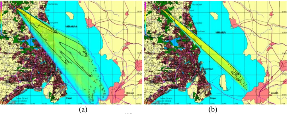
Selected numerical results of these exposure models in the greater Helsinki area are presented in the following, in order to illustrate the practical applications of the models. Examples of the spatial distributions of the PM2.5concentrations and population
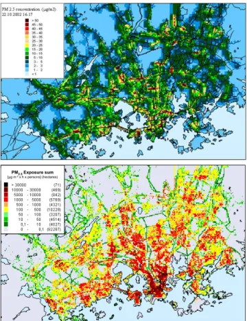
expo-5
sures are presented in Figs. 2a–b, computed by the above mentioned urban modelling system and the EXPAND model, respectively. The values correspond to a selected air pollution episode. The numerical results may be utilised, e.g., in planning poten-tial practical measures to be taken in the course of extremely severe episodes, or in evaluating the influence of air pollution episodes on the health of the population.
10
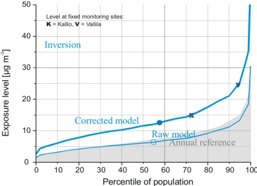
The probabilistic model was validated against personal exposure measurements col-lected earlier (H ¨anninen et al., 2005) and applied to the concentration data also with a correction procedure accounting for the air quality model error by using a correction factor based on ambient monitoring data.
In Fig. 3, the predictions of the raw model and corrected model are compared against
15
each other, and with the data of two PM2.5 monitoring stations that were operational in Helsinki. The raw model clearly underestimates the exposure levels. The station of Vallila (classified as urban, traffic) (“V” in the figure) represents high exposures, while the station of Kallio (urban background) (“K”) is a better representative of the urban mean population exposures. Similar relationships for the monitoring stations
20
were observed also for the other selected local episodes included in the preliminary model runs, in contrast to the two episodes that were primarily caused by long-range transport, for which both stations represented extremely high exposure levels (≈99th percentile; data not shown).
3.2 Oslo UAQIFS
25
The meteorological forecast system applied in the Oslo UAQIFS consists of the op-erational regional NWP model HIRLAM (Und ´en, 2002) and the meso-scale (non-hydrostatic) meteorological model MM5 (Dudhia, 1993, 1996; Grell et al., 1994). This
ACPD
6, 1867–1913, 2006
Integrated systems for urban forecasting
A. Baklanov et al. Title Page Abstract Introduction Conclusions References Tables Figures J I J I Back Close
Full Screen / Esc
Printer-friendly Version Interactive Discussion
EGU model system is operated off-line coupled with the UAP model AirQUIS (AirQUIS, 2005)
through a meteorological pre-processor interface program.
The Norwegian Meteorological Institute (met.no) provides meteorological forecasts for Norway, Northern-Europe and the adjacent ocean areas. For this purpose the HIRLAM models with 20 km resolution (HIRLAM20), 10 km resolution (HIRLAM10) and
5
5 km resolution (HIRLAM5) are applied in operational mode, HIRLAM20 up to 4 times a day. HIRLAM10 results are used as initial and boundary conditions for the MM5 model (Berge et al., 2002). The operational MM5 configuration consists of an outer 3 km horizontal resolution grid and an inner mesh with 1 km horizontal resolution, cov-ering quite a large area around Oslo. The MM5 horizontal grid is made up of 88×76
10
grid points. Both integration areas consist of 17 vertical layers (9 below 1500 m). The physic options presently applied in MM5 are: the first order MRF turbulence closure scheme (Hong and Pan, 1996), a 5-layer soil model with prescribed land-use depen-dent soil moisture availability, a cloud interactive radiation scheme, and explicit moist physics including the ice phase but with no parameterisation of cumulus and shallow
15
convection. Topography and 16 land use classes, of which one is defined as urban, are collected from the U.S. Geological Survey (USGS). At 60◦ north this data has a 0.5 km×0.9 km horizontal resolution, thus allowing a model horizontal resolution down to 1 km.
A meteorological pre-processing interface is transforming the model output of MM5
20
in order to meet the input requirements of the AirQUIS modelling system. The pre-processor takes care of the following tasks:
• Horizontal and vertical interpolation of the meteorological variables from the MM5 grid to the AirQUIS grid.
– In the present version, the horizontal model domain of AirQUIS is defined as
25
a subset of the 1 km2MM5 model domain, with identical fields of topography and land use classification in order to avoid the use of horizontal interpo-lation. Vertically, MM5 applies a terrain-following coordinate, defined from
ACPD
6, 1867–1913, 2006
Integrated systems for urban forecasting
A. Baklanov et al. Title Page Abstract Introduction Conclusions References Tables Figures J I J I Back Close
Full Screen / Esc
Printer-friendly Version Interactive Discussion
EGU an idealised hydrostatic pressure-distribution (Dudhia, 1993). In AirQUIS a
similar, but not identical, terrain following σ-coordinate has now been imple-mented (Slørdal et al., 2003). However, since the two models are applying identical fields of topography, the model layers may be defined approximately at the same physical height, thus avoiding vertical interpolation as well.
5
• Meteorological input variables transferred from MM5:
– 3-D: Horizontal wind components and temperature;
– 2-D: Precipitation, relative humidity, cloud cover, ground temperature,
dew-point temperature, topography, land-use classification, and surface rough-ness.
10
Note that the vertical velocity applied in AirQUIS is recalculated based on gridded horizontal wind fields from MM5 and the physical requirement of mass consistent (divergence-free) wind fields.
In the original forecast version the meteorological input required by AirQUIS were extracted from MM5 as if these were observed values available in the model grid
sys-15
tem. The dispersion parameters for the air quality forecast were then calculated using traditional Monin-Obukhov similarity theory following the methods of van Ulden and Holtslag (1985), Bøhler (1996), Slørdal et al. (2003). Utilizing this theory in combina-tion with the meteorological data extracted from MM5, quantities like the mixing height, the vertical profile functions in the surface layer, and the vertical eddy diffusivities, Kz,
20
were estimated.
An important part of the FUMAPEX project has been to review and improve this inter-face program between MM5 and AirQUIS in order to describe the dispersion conditions more consistently, thereby assuring an optimum use of the meteorological information available within the MM5 model (Slørdal and Ødegaard, 2005). The modifications that
25
have been tested are:
ACPD
6, 1867–1913, 2006
Integrated systems for urban forecasting
A. Baklanov et al. Title Page Abstract Introduction Conclusions References Tables Figures J I J I Back Close
Full Screen / Esc
Printer-friendly Version Interactive Discussion
EGU moisture, to estimate dispersion parameters like PBL height, vertical profile
func-tions of the turbulence parameters (σv and σw) and the vertical eddy diffusivity
Kz.
2. Direct application of the MM5 estimated PBL height and vertical eddy diffusivities (for either momentum or heat) in the dispersion model.
5
3. Same as point 2 above, but with application of other choices of turbulence schemes (including higher order closure) optionally available as part of the MM5 package.
Of these alternatives, the direct use of the MM5 estimated eddy diffusivities and PBL height (points 2 and 3 above) represents the closest coupling of the two model
sys-10
tems and should therefore be the preferred method. If improved “urbanisation” or “to-pographical” parameterisations are later incorporated into the NWP model, the effect of these parameterisations will directly influence the air quality forecast, and need not be “re-programmed“ in the interface module.
The air quality forecast of the Oslo UAQIFS is made by the PC-based Air Quality
In-15
formation System, AirQUIS (Bøhler and Sivertsen, 1998; Slørdal et al., 2003; AirQUIS, 2005). This system has been developed at NILU over the last years and has been ap-plied for estimating urban Air Quality in several cities (Laupsa and Slørdal, 2003; Wind et al., 2003). The combination of functionalities for emission inventories and numerical modelling within a GIS platform makes AirQUIS an effective UAQIFS tool.
20
The AirQUIS emission inventory module contains data such as fuel consumption, emission factors, physical description of stacks and processes, traffic load, vehicle composition, road slope, etc. Estimates of hourly emissions of the different air quality components are then calculated by application of an emission model. The emission data are split into three separate categories. These are point source emissions, line
25
source emissions and area (or grid distributed) emissions. The method applied to cal-culate the PM10 emissions from traffic-induced re-suspension, takes into account the
ACPD
6, 1867–1913, 2006
Integrated systems for urban forecasting
A. Baklanov et al. Title Page Abstract Introduction Conclusions References Tables Figures J I J I Back Close
Full Screen / Esc
Printer-friendly Version Interactive Discussion
EGU effect of vehicle composition, traffic speed and, during the winter season, the
percent-age of vehicles with studded tyres, on each road segment. Since practically no coarse particles are re-suspended when the roads are wet, hourly MM5-data on relative hu-midity, dew-point temperature and precipitation are included as input to the emission model.
5
The dispersion model within AirQUIS is an Eulerian grid model with embedded sub-grid line and point source Gaussian models for near source treatment (Slørdal et al., 2003). The model estimates urban background concentration levels in the Eulerian grid system, and near source concentrations from road transport (line sources) and individ-ual stacks (point sources) in individindivid-ual receptor points. Applying this model system,
10
air quality forecasts are carried out for NO2, PM10, and PM2.5. At present deposition (dry or wet) is not explicitly included as a sink term in these calculations. Tests per-formed with inclusion of deposition for PM10 revealed that this process had negligible effect on the calculated ambient concentration levels within the urban area (Slørdal et al., 2004). The regional background is taken into account by applying climatological
15
values of NO2, O3, PM10, and PM2.5at the open model boundaries. Presently AirQUIS treats PM10, and PM2.5 as inert species. The contributions from secondary aerosols are assumed to be included in the applied climatological background. For the predic-tion of NO2, however, AirQUIS makes use of the photostationary state assumption, i.e. an instantaneous equilibrium is assumed between the three reactions relating NO,
20
NO2 and O3. By applying this assumption the three components NO, NO2 and O3 may be determined by solving a second-order equation in O3, and the ambient con-centration of NO2is found by subsequent insertion. During wintertime in Nordic cities, this is a rather good approximation to the real situation. However, when the solar UV-radiation is stronger, either because of a more southern location or in summer, a net
25
ozone formation may take place even in urban areas at a certain distance from the main emission sources. Thus, the photostationary state assumption is then not valid and a more detailed chemical description is needed.
ACPD
6, 1867–1913, 2006
Integrated systems for urban forecasting
A. Baklanov et al. Title Page Abstract Introduction Conclusions References Tables Figures J I J I Back Close
Full Screen / Esc
Printer-friendly Version Interactive Discussion
EGU 2003). This module, which is an integrated part of AirQUIS, combines the calculated
outdoor concentration levels with information on the geographical distribution of the city inhabitants. The applied population distribution is stationary and based on information on the number of people living in each of the buildings within the city area. This corre-sponds to the deterministic-statistical approach described in Table 1. The application
5
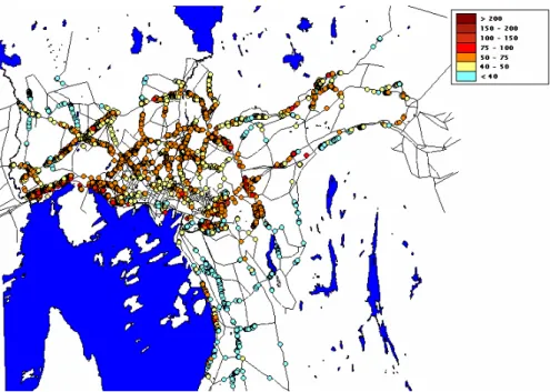
of the sub-grid line source model makes it possible to estimate more detailed concen-tration levels in receptor points in the vicinity of the major road network. These receptor points are placed in the geographical positions of buildings located close to the main road network (within a distance less than 200–500 m from the road). In AirQUIS these receptor points are termed “building points”. An example of a “building point”
concen-10
tration distribution is shown in Fig. 4. The colour coding indicates outdoor concentration level (in µg/m3) estimated at each building position. The near road exposure levels are thus obtained simply by combining the information on building inhabitants with the es-timated outdoor “building point” concentration. Exposure levels for inhabitants living in buildings located farther away from the main road network, i.e. buildings not defined
15
as an individual receptor points, are defined as the Eulerian grid point concentrations (urban background) for the grid cells hosting the buildings. In this way an exposure level is estimated for the total population.
The models within the Oslo UAQIFS are run from 00:00 UTC and 48 h ahead, MM5 on a 40-node Linux cluster and AirQUIS on a dedicated PC, and they are coupled
20
off-line through a meteorological pre-processor interface program. Since reduced air quality is mainly a wintertime problem in Nordic cities, the integrated system is oper-ational from October through April and daily forecasts are made for NO2, PM10, and PM2.5.
The time frame of the operational forecast procedure is: 04:30 local time – the
25
HIRLAM10 prediction is ready, 05:30 – the MM5 urban-scale NWP output is available, 06:30 – the AirQUIS air quality and population exposure forecast is finished. At 07:30 latest, the 06:30 – model output plots, and met.no’s duty forecaster’s comments on the weather situation are available on the web for the end-users.
ACPD
6, 1867–1913, 2006
Integrated systems for urban forecasting
A. Baklanov et al. Title Page Abstract Introduction Conclusions References Tables Figures J I J I Back Close
Full Screen / Esc
Printer-friendly Version Interactive Discussion
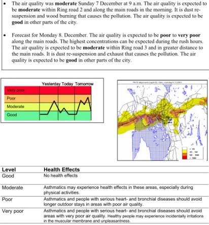
EGU The exposure estimates are actively used when assessing the air quality forecasts.
The air quality is defined in four classes: good, moderate, poor and very poor. The concentration limits defining the various air quality classes are presented for the com-pounds NO2 (hourly average), PM10 (daily average) and PM2.5 (daily average) in Ta-ble 2. By combining the forecasted concentration levels (calculated both in “building
5
points” and in the model grid system) with the population distribution, the number of in-habitants exposed within the various Air Quality classes can be estimated. An example of this type of exposure forecast is presented in Table 3.
In the Oslo UAQIFS it has been decided that at least 20 000 inhabitants need to be exposed to a certain air quality class, in order to define the general air quality belonging
10
to this class. In the example presented in Table 3, poor, moderate and good air quality is thus expected with regards to PM10, PM2.5 and NO2, respectively. In this case the overall air quality can be forecasted as poor, with an additional description of pollution type, and where (and possibly when) to expect the worst conditions.
Based on the above model results, monitoring data (air quality and meteorology) and
15
experience, the person responsible for the air quality forecast at the Oslo Public Health Agency (end-user) formulates an air quality bulletin that is published on the Internet for the general public. An example of such a bulletin is presented in the Appendix.
3.3 Copenhagen emergency decision-support system
The Danish nuclear emergency preparedness involves the Accident Reporting and
20
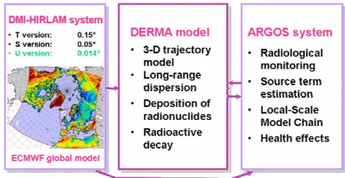
Guidance Operational System (ARGOS), developed by the Danish Emergency Man-agement Agency (DEMA) and collaborators (Hoe et al., 1999, 2002). The overall AR-GOS system consists of various parts as depicted in Fig. 5.
The ARGOS system utilises meteorological forecast data for the prediction of con-tamination, doses and other consequences on local and European scales. In Denmark
25
such data are provided by the Danish Meteorological Institute (DMI) four times a day. The 3-D data, which are transferred online to DEMA, are operationally extracted with 5 km (or experimentally 1.4 km) horizontal resolution forecasting up to 54 h ahead. For
ACPD
6, 1867–1913, 2006
Integrated systems for urban forecasting
A. Baklanov et al. Title Page Abstract Introduction Conclusions References Tables Figures J I J I Back Close
Full Screen / Esc
Printer-friendly Version Interactive Discussion
EGU Denmark the recent Danish operational NWP system (Sass et al., 2002) consists of two
nested models named DMI-HIRLAM-S05 and -T15, with horizontal resolutions of about 5 and 15 km, respectively. The vertical resolution of the operational versions is given by 40 levels, but for tests it has been increased to 60 vertical levels. Within the FUMAPEX project for the urban version of the ARGOS system, DMI has run several
experimen-5
tal versions of DMI-HIRLAM over Denmark and the Zealand island on which the city of Copenhagen is located with a horizontal resolution of 1.4 km and improvements of parameterisations of the urban sublayer processes and the urban physiographic data classification (cf. Baklanov et al., 2005a, b).
In order to meet the input requirements of the ARGOS system, a meteorological
pre-10
processing interface is translating and interpolating the NWP model output. The Local Scale Model Chain (LSMC) (Mikkelsen et al., 1997) comprises a meteorological pre-processor, which calculates deposition and stability parameters and wind fields based on the data provided by the DMI-HIRLAM model. These data are pre-processed and interpolated to yield data input fields for the RIMPUFF local-scale dispersion model
15
of ARGOS. Typically the fields are interpolated to a grid spacing of about 1 km or finer. The wind fields are interpolated either with the linearized flow model LINCOM (Mikkelsen et al., 1997; Astrup et al., 1996) or by 1/r2 weighting. In order to provide a more detailed wind field near the source, LINCOM is only used out to about 15 km from the source. The mixing height which is one of the important characteristics for
20
UAQ models, is included in the NWP output data or calculated separately by methods suitable for urban conditions (Sørensen et al., 1996; Zilitinkevich and Baklanov, 2002; Baklanov, 2002). However, the mixing height calculation may also be realised by the LSMC using different methods.
The LSMC is used in ARGOS for the calculation of actual and forecasted
ground-25
level air concentrations, wet and dry deposition, and ground-level gamma dose rates on short and medium range scales (up to about 100 km from the source). It includes the atmospheric local-scale dispersion model RIsø Mesoscale PUFF model (RIMPUFF) developed at the Risø National Laboratory (Mikkelsen et al., 1984, 1997). At distances
ACPD
6, 1867–1913, 2006
Integrated systems for urban forecasting
A. Baklanov et al. Title Page Abstract Introduction Conclusions References Tables Figures J I J I Back Close
Full Screen / Esc
Printer-friendly Version Interactive Discussion
EGU greater than about 20 km from the source, the DMI long-range atmospheric dispersion
model, the Danish Emergency Response Model of the Atmosphere (DERMA), can be used (Sørensen, 1998; Sørensen et al., 1998; Baklanov and Sørensen, 2001). Source terms for specific events, reactors and release categories are defined in the ARGOS database. Presently the nuclide database contains 361 radionuclides. The result of the
5
forecast includes nuclide specific air concentrations, ground contamination and gamma doses.
RIMPUFF is a fast puff diffusion code suitable for real-time simulation of puff and plume dispersion using meteorology changing in space and time. The model is pro-vided with a puff splitting feature to deal with plume bifurcation and flow divergence due
10
to channelling, and slope flow and inversion effects in non-uniform terrain. In RIMPUFF the puff diffusion processes are controlled by local turbulence levels, either provided directly from on-site measurements, or via pre-processor calculations. RIMPUFF is equipped with standard plume rise formulas, inversion and ground level reflections, as well as gamma dose algorithms.
15
DERMA is a three-dimensional Lagrangian long-range dispersion model using a puff diffusion parameterisation, particle-size dependent deposition parameterisations and radioactive decay. Earlier comparisons of simulations with the DERMA model versus the ETEX experiment involving passive tracer measurements gave very good results (Graziani et al., 1998). The DERMA model can be used with different sources of NWP
20
data, including the DMI-HIRLAM limited-area and the ECMWF global NWP models with various resolutions. The main objective of DERMA is the prediction of the atmo-spheric transport, diffusion, deposition and decay of a radioactive plume within a range from about 20 km from the source up to the global scale. DERMA is run on opera-tional computers at DMI. The integration of DERMA in ARGOS is effectuated through
25
automated on-line digital communication and exchange of data. The calculations are carried out in parallel for each NWP model to which DMI has access, thereby providing a mini-ensemble of dispersion forecasts for the emergency management.
ACPD
6, 1867–1913, 2006
Integrated systems for urban forecasting
A. Baklanov et al. Title Page Abstract Introduction Conclusions References Tables Figures J I J I Back Close
Full Screen / Esc
Printer-friendly Version Interactive Discussion
EGU the released substance in a separate street canyon or around a block of buildings), a
further level of nesting/downscaling can be included with usage of local-scale obstacle-resolving urban models, which have to carefully resolve the geometry of each building, e.g. the UK Urban Dispersion Model (UDM) (Brook et al., 2003). Such potential for local-scale urban simulation in the ARGOS system is considered by Thykier-Nielsen
5
and Roed (2003).
Due to the focus of the Copenhagen system on emergency preparedness, calcula-tion of the populacalcula-tion exposure in ARGOS has considerable specifics. First, mostly po-tential radioactive releases are considered, thus the individual and collective doses for population exposure (corresponding to the individual and
deterministic-10
statistical approaches in Table 1) are calculated for the acute phase and long-term effects. In a general sense the total doses to man for different groups of the popu-lation (e.g., adult, children, elderly) may be calculated based on the contributions of inhalation, external exposure, and ingestion (Fig. 6).
Inhalation exposures and body depositions are estimated for subjects passing
15
through the radioactive cloud. The deposition fields are further used to calculate soil contamination and effects of accumulation in crops and the human food chain. AR-GOS calculates external doses separately for adults and children. Effective doses, inhalation doses, thyroid doses and doses avertable by shielding are calculated. The dose calculations can be carried out by different methods including gamma dose rate
20
measurements, air concentrations of specific radionuclides, from estimated external gamma doses, and modelling of food chain effects (Hoe et al., 2000). Urban surface data bases, implemented into ARGOS, have resolutions up to 2 m resolving individual buildings. Population data bases in the current version of ARGOS have much poorer resolution, but it will be essentially improved for Danish cities soon.
25
In case of an accident or other type of emergency the ARGOS system provides air concentration, deposition, gamma dose fields, and total doses for the population. This information will be available to decision makers. The first ARGOS forecast is usually available 15–30 min after the information about the event was received.
ACPD
6, 1867–1913, 2006
Integrated systems for urban forecasting
A. Baklanov et al. Title Page Abstract Introduction Conclusions References Tables Figures J I J I Back Close
Full Screen / Esc
Printer-friendly Version Interactive Discussion
EGU To demonstrate the improved ARGOS system for the Copenhagen metropolitan
area, let us consider a hypothetical dirty bomb scenario, as described by Sohier and Hardeman (2005), with radioactive releases from the town of Hillerød close to Copen-hagen city. The source was Cs-137 released at a constant rate of 1011 Bq/s within 15 min. The information about the source term for a dirty bomb scenario is a very
5
uncertain issue. In this sensitivity study we consider a unit release of137Cs as an ex-ample. It could be considered as the first stage of forecasting for later adaptation when relevant data about the release strength become available. For the situation consid-ered on 19 June 2005, the hypothetical release took place from 00:00 to 00:15 UTC. In Fig. 7 the corresponding local-scale plume from the hypothetical atmospheric release
10
of137Cs, as calculated by RIMPUFF/ARGOS using meteorological data from the ur-banised U01 and operational S05 DMI-HIRLAM models and visualised by ARGOS, is shown for the Copenhagen metropolitan area. 250 m resolution land orography data were used for the ARGOS simulations. Figure 8 shows the differences in the mixing heights, simulated for the two versions of DMI-HIRLAM (urbanised U01 and
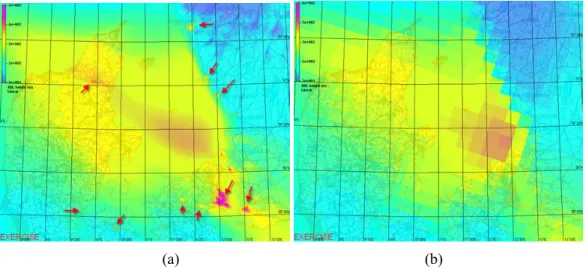
opera-15
tional S05) and considered in the above ARGOS simulations. The urban heat island effect, considered by the urbanised version U01, on MH over Copenhagen, Malm¨o and other Danish and Swedish cities (marked by arrows) is very visible in Fig. 8a. The mixing height considerably affects the air concentration and deposition levels of the contaminants.
20
The sensitivity of the dispersion pattern on the meteorological data (operational non-urbanised 5-km S05 and city-scale 1.4-km non-urbanised U01) is large: the differences in dispersion, as seen in Fig. 7, lead to different levels of contamination over the city areas and to different areas contaminated by the plume. Finally, the sensitivity of the popu-lation exposure (doses) to the urban improvements in the DMI-HIRLAM model, used
25
for the ARGOS simulations, have been studied. The collective doses for populations of different towns and areas of Copenhagen are very different for the non-urbanised operational S05 and for urbanised 1.4-km resolution U01 due to the urban effects con-sidered, i.e. 10.1 and 1.89 (in relative units) for the city of Hørsholm, and 7.16 and 2.72
ACPD
6, 1867–1913, 2006
Integrated systems for urban forecasting
A. Baklanov et al. Title Page Abstract Introduction Conclusions References Tables Figures J I J I Back Close
Full Screen / Esc
Printer-friendly Version Interactive Discussion
EGU for Birkerød.
4 Conclusions
Urban areas modify significantly many parameters that affect micrometeorology, includ-ing surface roughness, moisture, albedo and, correspondinclud-ingly, dynamical and thermal structures in the urban boundary layer. They are additionally affected by heating and
5
other energy consuming processes acting as anthropogenic energy sources. A large fraction of anthropogenic emissions to the atmosphere also occur within this very same area, where also a large majority of the western populations are located. Until now air quality models have been unable to reliably estimate air pollution levels especially during the events with the most urgent need for reliable information, namely the air
10
pollution episodes.
Latest improvements in numerical weather prediction models allow the inclusion of urban area features and therefore describe the state of the urban mixing layer more realistically than ever before. This is an essential prerequisite for reliable air quality modelling in urban areas.
15
Urban populations are mobile throughout their daily activities. Large fractions of the population concentrate on traffic arteries during the rush hours, when the air quality especially in these environments is the poorest. People concentrate in downtown ar-eas during the daytime simultaneously when the air quality is lowered through traffic and other emissions. On the other hand, urban populations spend large fractions of
20
their time in indoor environments, where the building partly shields them from the pol-lution in the ambient air. These phenomena have profound effects on actual population exposures within cities and should be accounted for when evaluating air quality and planning actions aiming at protection of the public health.
FUMAPEX demonstrates the integration of numerical weather prediction with air
25
quality modelling systems in six target cities and combines such urban air quality infor-mation and forecasting systems (UAQIFS) with the modelling of population exposures