HAL Id: hal-00330894
https://hal.archives-ouvertes.fr/hal-00330894
Submitted on 1 Jan 2001
HAL is a multi-disciplinary open access
archive for the deposit and dissemination of
sci-entific research documents, whether they are
pub-lished or not. The documents may come from
teaching and research institutions in France or
abroad, or from public or private research centers.
L’archive ouverte pluridisciplinaire HAL, est
destinée au dépôt et à la diffusion de documents
scientifiques de niveau recherche, publiés ou non,
émanant des établissements d’enseignement et de
recherche français ou étrangers, des laboratoires
publics ou privés.
Narcisse Zahibo, E. N. Pelinovsky
To cite this version:
Narcisse Zahibo, E. N. Pelinovsky. Evaluation of tsunami risk in the Lesser Antilles. Natural Hazards
and Earth System Science, Copernicus Publications on behalf of the European Geosciences Union,
2001, 1 (4), pp.221-231. �hal-00330894�
c European Geophysical Society 2001
and Earth
System Sciences
Evaluation of tsunami risk in the Lesser Antilles
N. Zahibo1and E. N. Pelinovsky2
1Universit´e Antilles Guyane, UFR Sciences Exactes et Naturelles D´epartement de Physique, Laboratoire de Physique Atmosph´erique et Tropicale 97159 Pointe-`a-Pitre Cedex, Guadeloupe (F.W.I.)
2Laboratory of Hydrophysics and Nonlinear Acoustics, Institute of Applied Physics, Russian Academy of Sciences, 46 Uljanov Street, 603950 Nizhny Novgorod, Russia
Received: 27 July 2001 – Revised: 11 February 2002 – Accepted: 14 February 2002
Abstract. The main goal of this study is to give the
prelimi-nary estimates of the tsunami risks for the Lesser Antilles. We investigated the available data of the tsunamis in the French West Indies using the historical data and catalogue of the tsunamis in the Lesser Antilles. In total, twenty-four (24) tsunamis were recorded in this area for last 400 years; six-teen (16) events of the seismic origin, five (5) events of vol-canic origin and three (3) events of unknown source. Most of the tsunamigenic earthquakes (13) occurred in the Caribbean, and three tsunamis were generated during far away earth-quakes (near the coasts of Portugal and Costa Rica). The estimates of tsunami risk are based on a preliminary analysis of the seismicity of the Caribbean area and the historical data of tsunamis. In particular, we investigate the occurrence of historical extreme runup tsunami data on Guadeloupe, and these data are revised after a survey in Guadeloupe.
1 Introduction
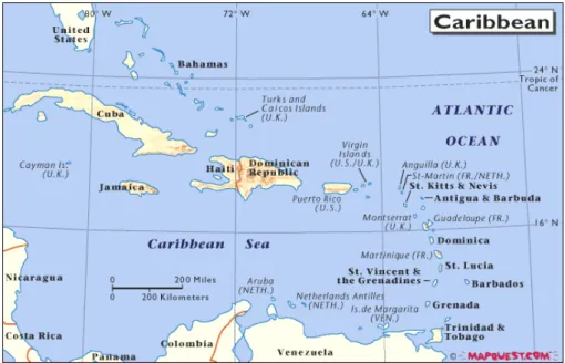
The evaluation of the risk of tsunami on the scales of the Lesser Antilles is closely related to the evaluation of the seis-mic and volcanologic risk. The seisseis-mic risk is high in this region, mainly because it results there from an active geo-dynamic context, also expressed by volcanic activity along a contact zone materialized by the arc of the Lesser Antilles, and the tectonic deformations in the vicinity of this contact zone. The Lesser Antilles volcanic arc draws a curve of 850 km in length and a 450 km ray. It runs from the southern American continental margin to the Anegada passage which marks the current limit with the Greater Antilles (shelf of Puerto Rico and Virgin Islands).The arc results from subduc-tion of the American plate under the Caribbean plate (Fig. 1). These movements of plates control the tectonic, volcanic and seismic activity of the Lesser Antilles arc. Each plate is also the seat of a network of major faults. The north and the east of the Caribbean corresponds to an active margin, related Correspondence to: N. Zahibo (narcisse.zahibo@univ-ag.fr)
to the subduction of the American plate under the Caribbean plate at a rate of about 2 cm/year. The subduction angle is stronger in the center of the arc (Martinique, 60◦) than in the north (Guadeloupe, 50◦) and the south. This type of subduc-tion is considered as an intermediate type between the two fundamental types (BRGM, 1990):
– The “Chili” type, characterized by a high speed of
con-vergence, a mode of compression in the overlaping plate and a strong coupling between the two plates. The sub-duction earthquakes are very strong (magnitude higher than 8);
– The “Mariane” type, characterized by a low speed of
convergence, a mode of distension in the overlaping plate and, on the contrary, “a decoupling” of the plates. The subduction earthquakes are, in general, weaker than in the previous case.
Taking into account both the important age (about 100 mil-lions years) of the American oceanic crust in subduction un-der the Lesser Antilles arc and the weak rate of convergence between the plates, we can retain a probable value of about 7.5 for the maximum magnitude of subduction earthquakes in the Caribbean. The distribution of historical earthquakes throughout the arc confirms such a probability (Fig. 2). We can notice that the seismicity of the Lesser Antilles is located for the major part in the eastern sector of the arc. The Amer-ica/Caribbean subduction zone and the tectonic zone (inside the American plate), with its mechanisms of normal and re-verse faults, are the zones likely to store the most energy and are thus, the potential sources of tsunami. Tectonic tsunamis are expected to be more important regionally than volcanic and landslide tsunamis.
Some theories (BRGM, 1990) estimate that the overlap of plates is strongly coupled and that the slip is partially and temporarily blocked on broad portions of the arc. This seems to explain the seismic “gap” east of Guadeloupe, identified by Dorel (1981) which is likely to be filled in the immediate
CT: Cayman Trough, OF: Orient Fault zone, SF: Septentrional Fault, EPGF: Eqilliro-Plantain Garden Fault zone; BR: Beta Ridge; MT: Muertos Trough; PRT: Puerto Rico Trench; EPF: El Pilar Fault zone
Fig. 1. Geodynamic context, Bathymetry from Smith and Sandwell (1997).
future by a very strong subduction earthquake, a probable source of tsunami.
Tsunamis in the Caribbean region are not very rare events. The first version of the Caribbean regional tsunami catalogue prepared by Lander and Whiteside (1997) covers the period from 1530 to 1991 and contains 56 events. For the last 100 years, the catalogue lists 20 tsunamis, about one every 5 years. There is a high probability of a tsunami occurring in the Caribbean comparable with other areas and this risk should be specially investigated. James Lander and Karin O’Loughlin are preparing the extended version of tsunami catalogue to be published soon in the special issue of the in-ternational journal “Natural Hazards”. Weissert (1990) has calculated the tsunami travel time charts for the Caribbean Sea. The travel time for a complete crossing of the Caribbean is estimated at 3.2 h laterally and 1.5 h meridionally. These charts can be used for developing the regional tsunami warn-ing system. Tsunamis of volcanic origin in the Caribbean were also studied, for instance, the numerical simulation shows that the potential debris avalanche in the Soufriere volcano (Montserrat, Lesser Antilles) can induce the tsunami waves of 1–2 m at distances of 10 km from the generated area (Heinrich et al., 1998).
The goal of this paper is to study the tsunami hazard in the Lesser Antilles, the group of islands from Anguilla in the north, to Trinidad and Tobago in the south. The location of the Lesser Antilles Islands is shown in Fig. 3. Data of histori-cal tsunamis in this area are discussed in Sect. 2. They are an-alyzed in Sect. 3. The rough estimations of the tsunami risk for some islands of the Lesser Antilles (Antigua, Barbados) are presented. Results of a field trip in Guadeloupe (France), where the extreme high tsunami wave heights (18 m) were
recorded during two tsunamis, are discussed in Sect. 4. These historical data are revised.
2 Historical tsunami data
Recently, the tsunami catalogue for the whole Caribbean Sea was prepared (Lander and Whiteside, 1997). Also, data from the NOAA/NESDIS National Geophysical Data Center is used. Not all sources and original descriptions are available now; this leads to the preliminary character of results. Nev-ertheless, some rough conclusions can be done for an esti-mation of tsunami risk for the Lesser Antilles. According to the available data, 24 tsunami events in the Lesser Antilles can be selected for the whole historical period. The earth-quakes produced most of the events (16). Sometimes the origin of tsunami is not quite clear, because heavy weather conditions were at the time of the shocks. Four tsunamis are from volcanic eruption origin. The source of three tsunamis is unknown.
2.1 Tsunami of the seismic origin (16 events)
First of all, the two teletsunamis, which crossed the Atlantic, should be mentioned.
1 November 1755. The significant tsunami (with maximal height
of 7 m) was induced by the famous Lisbon earthquake. The tsunami waves crossed the Atlantic Ocean for 7–8 h and manifested on many islands of the Lesser Antilles. Table 1 contains the observed runup heights in the Lesser Antilles taken from NOAA/NESDIS web site1. Lander and Whiteside (1997) give wave heights 1.5–1.8 m for Barbados (not 0.8–1.5 m as in Table 1) and add, “the water was
Epicenter and magnitude according to Feuillard (1985)
b Revised epicentre according to BRGM (1990)
Some far major earthquakes weakly felt in Guadeloupe are not represented
Fig. 2. Historic seismicity: localisation
of the area of the most probable epi-centers of the strongest historical earth-quakes felt in Guadeloupe.
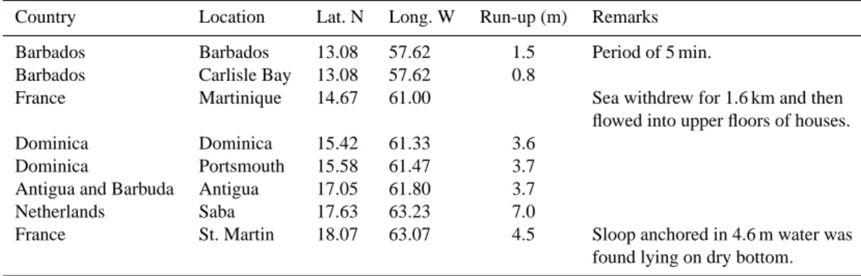
Table 1. Runup heights of the 1755 teletsunami in Lesser Antilles
Country Location Lat. N Long. W Run-up (m) Remarks Barbados Barbados 13.08 57.62 1.5 Period of 5 min. Barbados Carlisle Bay 13.08 57.62 0.8
France Martinique 14.67 61.00 Sea withdrew for 1.6 km and then flowed into upper floors of houses. Dominica Dominica 15.42 61.33 3.6
Dominica Portsmouth 15.58 61.47 3.7 Antigua and Barbuda Antigua 17.05 61.80 3.7 Netherlands Saba 17.63 63.23 7.0
France St. Martin 18.07 63.07 4.5 Sloop anchored in 4.6 m water was found lying on dry bottom.
Fig. 3. The chart of the Caribbean Sea.
Table 2. Runup heights of the 1751 tsunami in Lesser Antilles
Location Lat. N Long. W Run-up Remarks (m)
Barbados 13.17 59.53 3.6 Portion of coast fell into the sea Martinique 14.67 61.00 1.8
Antigua 12.00? 62.00? 4.5 St. Martin 18.07 63.07 7.0
black as ink” relating this to a possible local landslide. They also pointed out that “the lowlands on most of the other French Islands were inundated”. An agitation of the sea at Antigua is also reported by Affleck (1809).
31 March 1761. The second teletsunami was generated again by an
earthquake close to Lisbon in 1761, and it “caused an extraordi-nary flux and reflux of the sea at Barbados“ (Lander and Whiteside, 1997). Wave height is 1.2 m according to NOAA/NESDIS data. The other 14 events have been induced by the earthquakes that oc-curred in the Caribbean Sea or with unknown locations (some of them probably had atmospheric origin). Below are the descriptions of these events.
20 November 1751. Tsunami wave heights induced by the
earth-quake (its parameters are unknown) are given in Table 2 taken from NOAA/NESDID web site (coordinates of Antigua are corrected).
19 March 1802. Coordinates of the earthquake epicenter: 17.2◦N 62.4◦W. It was accompanied by great agitation of the sea at Antigua and St. Kitts (St. Christopher) Islands (NOAA/NESDIS data).
30 November 1823. At 14:45 LT, a strong earthquake (epicenter
coordinates: 14.4◦N 61.1◦W; NOAA/NESDIS data) was followed
by a tidal wave at 15:10 LT, which caused some damage in Saint Pierre Harbour, Martinique (Lander and Whiteside, 1997).
9–13 September 1824. Earthquakes were felt at Basse Terre
(Guadeloupe) on 9 and 13 September. There was a remarkable rise and fall of the tide at Plymouth (Montserrat). There had been a terri-ble storm and heavy rain on 7–9 September (Lander and Whiteside, 1997).
30 November 1824,. Severe shocks at Saint Pierre Harbor
(Mar-tinique) were reported. A very high tide threw many ships upon the strand. Heavy rain followed lasting 10 days (Lander and Whiteside, 1997).
3 December 1831. An earthquake occurred. The sea was in a state
of violent agitation on Trinidad, Antigua and St. Kitts (St. Christo-pher) Islands. Note the large distance between reporting areas. An earthquake was also reported at Grenada, St. Vincent (Lander and Whiteside, 1997).
7 May 1842. A strong earthquake (magnitude > 8.0; epicenter
co-ordinates: 18.5◦N 72.5◦W) at 17:30 LT produced the tsunami waves (Lander and Whiteside, 1997). Their heights are summa-rized in Table 3 (NOAA/NESDIS data). Coordinates of Gouyave and Grenada in Table 3 are corrected. Lander and Whiteside (1997) give 8.3 m for Deshaies and 1.8 m for Sainte-Rose.
8 February 1843. A strong earthquake (magnitude, 8.3;
coordi-nates, 16.5◦N 62.2◦W; depth < 50 km; NOAA/NESDIS data) was felt at Guadeloupe, St. Lucia, St. Kilts, Montserrat, Martinique, and other islands. The sea rose 1.2 m at Antigua but sank again imme-diately (Lander and Whiteside, 1997). The motion of the sea on the coast at Pointe-`a-Pitre (Guadeloupe) was, in fact, rather weak. Water barely invaded the quays of the city on some steps, which were, however, relatively low about its level. It had been similar in Basse-Terre and Isles de Saintes (Guadeloupe), in Dominica, etc. (Sainte-Claire Deville, 1867).
18 November 1867. An earthquake (magnitude, 7.5, depth
Table 3. Runup heights of the 1842 tsunami in Lesser Antilles
Location Lat. N Long. W Run-up (m) Remarks
Gouyave, Grenada All floatable objects carried away Bass-Terre, Guadeloupe 16.00 −61.73 0.9
Deshaies, Guadeloupe 16.30 −61.58 18.3 20 m wave carried off floatable objects Sainte-Rose, Guadeloupe 16.33 −61.70 18.3 20 m wave carried off floatable objects St. John’s, Antigua 17.13 −61.85 3.1
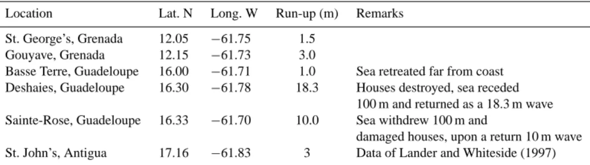
Table 4. Runup heights of the 1867 tsunami in Lesser Antilles
Location Lat. N Long. W Run-up (m) Remarks St. George’s, Grenada 12.05 −61.75 1.5
Gouyave, Grenada 12.15 −61.73 3.0
Basse Terre, Guadeloupe 16.00 −61.71 1.0 Sea retreated far from coast Deshaies, Guadeloupe 16.30 −61.78 18.3 Houses destroyed, sea receded
100 m and returned as a 18.3 m wave Sainte-Rose, Guadeloupe 16.33 −61.70 10.0 Sea withdrew 100 m and
damaged houses, upon a return 10 m wave St. John’s, Antigua 17.16 −61.83 3 Data of Lander and Whiteside (1997)
Virgin Islands. It induced tsunami waves; their heights are given in Table 4 (NOAA/NESDIS data). At St. Barthelemy and St. Martin, there was some damage; at St. Vincent and Martinique, there was unusually high water; at Pointe-`a-Pitre and Isles des Saintes (Guadeloupe), there was a slight swell.
11 March 1874. A submarine shock to the southeast of St. Thomas
(Virgin Islands) shook the island and ships in the harbor. At Do-minica, the steamer Corsica reported at 05:00 LT a series of heavy rollers in the harbor during half an hour, rendering communication with the shore impossible. They did not feel the earthquake (Lander and Whiteside, 1997).
25 December 1969. Earthquake had parameters: magnitude, 7.0;
depth 15 km; epicenter coordinate, 15.8◦N 59.7◦W. Tsunami with the height of 0.1 m was recorded in Barbados, Dominica and An-tigua (NOAA/NESDIS data). Lander and Whiteside (1997) give the maximum amplitude 46 cm at Barbados.
16 March 1985. A moderate earthquake caused damage at Montserrat. It was felt at Antigua and St. Kitts. A several cm tsunami were recorded at Basse Terre, Guadeloupe (Lander and Whiteside, 1997). NOAA/NESDIS gives for earthquake:
Mw = 6.4; depth 14 km; epicenter coordinates, 17.0◦N 62.5◦W. We can observe that this moderate earthquake generated tsunami due to the its low depth.
22 April 1991. A major earthquake of magnitude 7.4 struck the
re-gion surrounding the eastern border of Costa Rica and Panama2. The epicenter (9.6◦N 83.4◦W) was at a depth of about 17 km. The reviewer indicates that there are some stories of a tsunami observed in a bay of the Martinique.
9 July 1997. Earthquake had parameters: Mw =6.9; depth 15 km; epicenter coordinates, 10.6◦N 63.5◦W. There is information of a
2data from www.eqe.com/publications/costaric/costaric.htm
tsunami at Tobago (NOAA/NESDIS data). The very low depth of this moderate earthquake is probably responsible for the generation of the tsunami.
2.2 Tsunamis of volcanic origin (5 events)
Data of tsunamis of volcanic eruption are more rare (NOAA/NESDIS data).
17 February 1842. Probably, the volcanic eruption produced minor
a tsunami at Antigua.
5 May 1902. In 1902, the volcanic eruption of the Montagne Pel´ee
in Martinique occurred from 2 May to 8 May. On 5 May 1902, a 35-m-lahar from Montagne Pel´ee swept down Rivi`ere Blanche, north of the nearby town of St. Pierre. When it reached the sea, it generated a 4–5 m high tsunami that only affected the lower part of the town, killing one hundred people (Bryant, 2001).
7 May 1902. The 7 May 1902 eruption produced a pyroclastic flow
that swept into the harbour of St. Pierre and generated a tsunami that traveled as far as Fort de France, 19 km away (Bryant, 2001).
3 March 1911. The extraordinary waves noticed on the coast of
Trinidad and Tobago were following an explosion of mud-volcano island. No quantitative information about the tsunami characteris-tics is available.
26 December 1997. A tsunami was observed in the southern part
of Montserat, generated by a pyroclastic flow (Cader et al., 1998). It is necessary to mention that the numerical simulation by Heinrich et al. (1998, 1999a, b) shows the potential danger of the tsunami ap-pearance at the possible eruption of the Soufriere volcano (Montser-rat). Table 8 summarizes the locations due to these volcanic erup-tions.
Table 5. Tsunami heights at Antigua
Year 1751 1755 1842 1843 1867 1969 Runup (m) 4.5 3.7 3.1 1.2 3 0.1
Table 6. Tsunami heights at Barbados
Year 1751 1755 1761 1969 Runup (m) 3.6 1.5 1.2 0.46
2.3 Tsunamis of unknown origin (3 events)
24 April 1767. The sea was much agitated and had ebbed and
flowed in an unusual way at Barbados and Martinique (Lander and Whiteside, 1997).
26 July 1837. Large waves were reported at Martinique (NOAA/NESDIS data).
2 August 1837. Several shocks accompanied by a large wave
oc-curring during a hurricane at Martinique. The source of wave is uncertain (Lander and Whitesite, 1997).
3 Preliminary analysis of historical tsunamis
The quantitative information of the parameters of the tsunamis given above is not quite good enough for statisti-cal analysis. But we should mention that the total number (21) of tsunami events for the period 1530–2000 is high, and the return period for the Lesser Antilles, as a whole, can be estimated in 24 years. This value of the return period is char-acterized for other regions of the Atlantic, for instance, for the Mediterranean (Soloviev et al., 2000; Pelinovsky et al., 2002). So, the risk of tsunamis for the Lesser Antilles seems to be real.
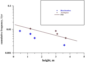
For estimation of the tsunami risk for each island of the Lesser Antilles, the historical data should be collected for each location. In fact, only a few data are available for some locations in the Lesser Antilles, as a rule, one to three val-ues. The maximal number of runup heights is known for the Antigua Island, summarized in Table 5. Considering the total period of observation as above over 470 years, the cu-mulative frequency of tsunami appearance can be calculated (Fig. 4). Roughly speaking, the return period of the tsunami wave with runup exceeding 2–3 m can be estimated in 100 years. For Barbados, tsunamis runup are known for the four events only (Table 6). The calculated cumulative frequency for tsunamis in Barbados is presented in Fig. 4 as well. The curves for Antigua and Barbados located in different parts of the Lesser Antilles, are relatively close to each other; this demonstrates the same character of tsunami manifestations on both islands. The regression line: cumulative frequency
0 1 2 3 4 5 height, m 0.001 0.01 0.1 cu m u la ti ve f requenc y, 1 /yr Barbados Antigua Fit
Fig. 4. Occurrence of tsunamis in Barbados and Antigua Islands.
(1/ h) – wave height (m), based on data for Antigua is 1n f = 0, 36H − 4.11
and is also presented in Fig. 4 by the solid line. This re-gression can be used for the rough estimation of the tsunami appearance at the Lesser Antilles. In particular, its value for weak amplitudes, f = 0.015 1/year, characterizes the fre-quency of occurrence of tsunamis in the region. Due to the common origin of tsunami by the underwater earthquakes in the Caribbean, this value should be the same (or slowly var-ied) for each island. The characteristic slope of this curve, of course, depends on the bathymetry of each island and should vary more significantly from one island to another. It can-not be found from given historical data, and this numerical simulation of the tsunami propagation may be effective in generating missing data for each island. Such an approach to create the synthetic tsunami catalogue for other regions is discussed, for instance, by Curtis and Pelinovsky (1999) and Choi et al. (2001). It will be developed for the tsunamis in the Lesser Antilles.
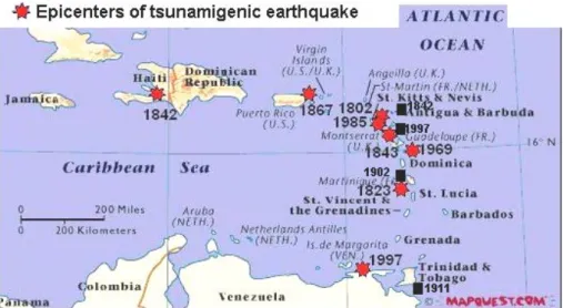
For the successful numerical simulation of the tsunami propagation, the parameters of tsunamigeneric earthquakes should be analyzed. Table 7 summarizes quantitative in-formation of 13 tsunamigeneric earthquakes that occurred in the Caribbean Sea with known or unknown coordinates3. The epicenters are known for 8 events (they are presented in Fig. 5); the earthquake magnitude is given for 6 events, and only 5 events with “good” seismic data are provided by the observed tsunami wave heights.
First of all, we may mention that 5 tsunamigeneric earth-quakes (from 8 documented events) occurred in the Lesser Antilles directly. Two strong tsunamis were initiated by the earthquakes at the Greater Antilles (Haiti, 1842, and Virgin Islands, 1867). The earthquake in South America induced 3Figure 2 shows additionally the 6 closest earthquakes with
magnitudes higher than 7 which can potentially generate tsunami, but no data for these events is available.
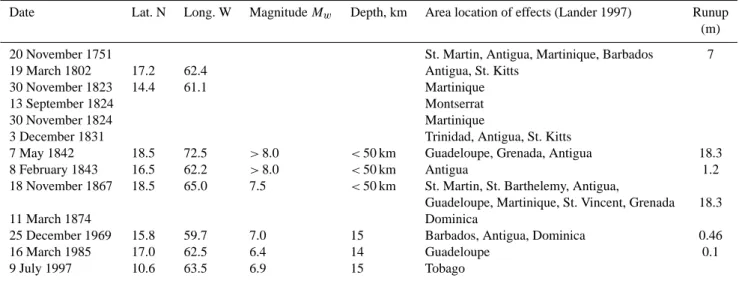
Table 7. Parameters of tsunamigenic earthquakes for the Lesser Antilles
Date Lat. N Long. W Magnitude Mw Depth, km Area location of effects (Lander 1997) Runup (m) 20 November 1751 St. Martin, Antigua, Martinique, Barbados 7 19 March 1802 17.2 62.4 Antigua, St. Kitts
30 November 1823 14.4 61.1 Martinique
13 September 1824 Montserrat
30 November 1824 Martinique
3 December 1831 Trinidad, Antigua, St. Kitts
7 May 1842 18.5 72.5 >8.0 <50 km Guadeloupe, Grenada, Antigua 18.3 8 February 1843 16.5 62.2 >8.0 <50 km Antigua 1.2 18 November 1867 18.5 65.0 7.5 <50 km St. Martin, St. Barthelemy, Antigua,
Guadeloupe, Martinique, St. Vincent, Grenada 18.3
11 March 1874 Dominica
25 December 1969 15.8 59.7 7.0 15 Barbados, Antigua, Dominica 0.46
16 March 1985 17.0 62.5 6.4 14 Guadeloupe 0.1
9 July 1997 10.6 63.5 6.9 15 Tobago
Table 8. Location of landslide or pyroclastic flows due to volcanic
eruptions
Date Island Lat. N Long. W
17 February 1842 Antigua 16.5 62.2 5 May 1902 Martinique 14.4 61.0 7 May 1902 Martinique 14.4 61.0 3 March 1911 Trinidad and Tobago 9.5 61.00 26 December 1997 Montserrat 17 62
Table 9. Focal depth of earthquakes in the Lesser Antilles with
magnitude larger than 7
Earthquakes Magnitude Mw Depth
1690 7.5 <50 km 1839 7.3 >50 km 1843 8.0 30 km 3 October 1914 7.4 100 km 1953 7.5 >50 km 8 October 1974 7.4 40 km
a weak tsunami at Tobago. We should also add two telet-sunamis that arrived from Portugal. So, the ttelet-sunamis at the Lesser Antilles can be related with both the closest and the far away earthquakes.
The earthquakes with magnitudes 6.3–7.0 generated weak tsunamis (maximum recorded height is 46 cm)4. Signifi-cant tsunamis were initiated by the strong earthquakes with a magnitude more than 7.5. This is typical for the Pacific 4The physical mechanism of tsunami generation by weak
earth-quakes is not quite clear. Probably, they initiated submarine land-slides and this should be a subject of special investigation.
Ocean as well and characterizes the general properties of the mechanism of the tsunami generation. Table 9 summa-rizes the focal depth of 6 earthquakes with magnitude larger than 7, very close to the Lesser Antilles arc (BRGM, 1990). The earthquakes of 1839, 1914 and 1953 had a depth larger than 50 km. It is not quite clear why the strongest yet shal-low earthquake in 1843 (magnitude > 8.0; depth < 50 km) occurred in the triangle of Guadeloupe, Montserrat and An-tigua, induced relatively weak tsunamis which were reported at Guadeloupe, Dominica and Antigua (in last location, the wave height was 1.2 m); the original observation data of the 1843 tsunami should be checked. There are no available tsunami data about the shallow earthquakes of 1690 and 1974 that occurred near Antigua.
For numerical simulation, the 1867 event is of great in-terest, because it was felt on most islands of the Lesser An-tilles, as well on the Greater Antilles (in particular, maximum height at the Virgin Islands, near the epicenter, was reported as 9 m in Frederiksted Harbour, St. Croix Island); this is well documented (Reid and Taber, 1920; Murty, 1977). Below is the description of this event for Lesser Antilles taken from the paper by Reid and Taber (1920) written 50 years later after tsunami:
“Still farther east some damage was done in the islands of Saba, St. Martin, and St. Bartholomew; a high wave is said to have invaded Saba Island; and the sea rose pretty high at St. Christopher. In Antigua the shock was called “severe”, which must be an exaggeration, probably due to the alarm caused by the sea, which was reported to have risen eight or ten feet in the harbor of St. John, on the west coast of the Island. The shock was weakly felt in Guadeloupe and Marie Galante, and apparently not at all in Martinique. There is no report from Dominica, but it is possible that the shock was barely sensible there. At Basse-Terre, Guadeloupe, “towards three o’clock”, the sea suddenly retired a long distance and then “after a certain interval”, advanced; this phenomenon
228 N. Zahibo and E. N. Pelinovsky: Evaluation of tsunami risk in the Lesser Antilles
Fig. 5. The chart of the Caribbean Sea
with epicenters of tsunamigenic earth-quakes and location of tsunamigenic landslide in the Lesser Antilles.
was repeated once, and then all was quiet. The total range in the height of the sea from its lowest to its highest level was about two meters. From Deshayes and Sainte-Rose, in the northwest part of the island, comes a more sensational report; the sea is said to have withdrawn and to have returned in a wave “at least 60 feet high”, which broke over the shore and carried off all floatable objects. Three of these great waves are described. The account is undoubtedly much ex-aggerated. In both the accounts from Guadeloupe the waves are said to have arrived at about three o’clock, and imme-diately after the light shocks. There was an error either in the report or in the clocks of the island; probably in both; for the shock must have been felt at about three o’clock lo-cal time, and the waves must have arrived about one hour later. Point-`a-Pitre, on the southern side of the island, seems to have felt the shock, but it is so protected, at the head of the Petit-Cul-de-Sac, that the waves were barely, if at all, noticeable there. The waves were also noted at Martinique, but we have no description of them. At St. Vincent “the wa-ter was observed to be unusually high; but nothing occurred to attract attention”, though at Becquia Island, ten or fifteen miles farther south, there were three great slow waves, the water rising about six feet above its usual level; the whole event lasted about forty minutes, and the water was not in the least agitated. The next island from which we have a report is Grenada; at St. George, about 17:20 LT, the sea suddenly sank four or five feet, leaving the reef, in front of the lagoon, bare; it then rose as much. This was repeated six times and then all was quiet. At Gouyave, nearby, the sea began to ebb and flow about 17:00 LT with a range of about twenty feet, doing some damage to the town. Twenty feet seems to be an exaggeration; the time of the waves seems also inaccurate; they would have arrived there at about 16:30 LT. The shock was not felt at Grenada; the slight shocks felt in that island at 21:00 LT, 18 November and 01:00 LT on the 19 November were probably connected with the strong shock on the South
American coast on 19 November.”
The surprising information of 18.3 m at Guadeloupe dur-ing the 1867 event, and also durdur-ing the 1842 event, should be specially inspected, taking into account the contradiction between data in various sources.
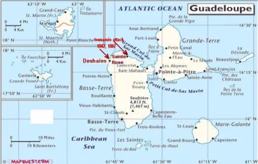
4 Have extreme wave heights occurred in Guadeloupe?
Analysis of tsunami wave heights for whole historical period at the Lesser Antilles shows that the extreme wave heights of the same value in 18.3 m (or 60 feet) were recorded in Guade-loupe only during the tsunamis of 1842 and 1867. They were recorded in the northwestern part of the island, at Deshaies and Sainte-Rose (Fig. 6). Reid and Taber (1920) mentioned that this is an overestimation for the 1867 event. At first, let us systematize the descriptions of tsunamis in these loca-tions.
7 May 1842. A strong earthquake (magnitude > 8.0) occurred at
Haiti. There was extensive destruction caused by the earthquake and tsunami; at Port-de-Paix the sea receded 60 m and the returning wave covered the city with 5 m of water. About 200–300 of the city’s 3000 inhabitants were killed by the earthquake and tsunami (NOAA/NESDIS data and Lander and Whiteside, 1997).
The description of the tsunami in both locations in Guadeloupe, at Deshaies and Sainte-Rose, is the same: a wave carried away all floatable objects. There is no information of damage in villages. According to the NOAA/NESDIS data, the wave runup height was 18.3 m in both locations. According to Lander and Whiteside (1997), the wave runup height was 8.3 m at Deshaies and 1.8 m at Sainte-Rose.
18 November 1867. This earthquake had the lesser magnitude
(7.5), but it was closer to Guadeloupe; its epicenter was at the Virgin Islands.
According to NOAA/NESDIS data, the tsunami wave runup height at Deshaies was 18.3 m. Houses were destroyed; the
Fig. 6. Map of Guadeloupe.
sea receded 100 m, and returned as a 18.3 m wave. At Sainte-Rose, the wave runup height was 10 m. The sea withdrew 100 m and damaged houses upon return as a 10 m wave.
According to Lander and Whiteside (1997), at Deshaies, houses in the village were destroyed. At Sainte-Rose, there was a 10 m wave. The sea withdrew 100 m and flooded and damaged houses on return.
According to Reid and Taber (1920), from Deshaies and Sainte-Rose, comes a more sensational report; the sea is said to have withdrawn and to have returned in a wave “at least 60 feet high”, which broke over the shore and carried off all floatable objects. Three of these great waves are described. According to Murty (1977), at Deshaies and Sainte-Rose, the tsunami runup was said to have exceeded 18.3 m.
The papers cited above give the same description of phe-nomenon for both locations: the first wave has the negative polarity and the sea withdrew 100 m. The second wave was positive and it climbed on the beach (probably, as the broken wave; see Reid and Taber, 1920), destroying houses. The difference is in the height of the crest: 18.3 m in both loca-tions; or 18.3 m at Deshaies and 10 m at Sainte-Rose. Also, Reid and Taber (1920) informed us that this large wave car-ried off all floatable objects, and in total, three large waves were observed. Reid and Taber (1920) cited an original letter from Sainte-Claire Deville (1867). We found this letter; it gives the following description of tsunami (translating from French). At Deshaies, one writes: Great disaster! The sea devastated and thrusted almost all the houses of the village. It is no longer possible to have bread. The inhabitants took refuge in the church.
An inhabitant of Sainte-Rose wrote: “Today, around 15:00 LT, the sea suddenly receded on more than one hun-dred meters of the littoral; this withdrawal was preceded by light oscillations from an earthquake, of which the duration can be estimated at five or six seconds. Then suddenly, a first
blade, at least 60 feet high, rising about 3 miles to the north in the open sea has rolled violently towards the ground, im-mersing all the littoral and flooding the houses. A second and third of these enormous blades, rolling from north to south, followed, with short intervals, reversing all in their passage.” Also, this letter informs us of tsunami waves in other lo-cations of Guadeloupe. At Basse-Terre, around 15:00 LT, the sea suddenly receded from the land on a long distance. After a certain time, it returned to its level. The population was very frightened but there was no damage. In the harbor of Pointe-`a-Pitre, the variation of the sea level and coast were less. So, the original letter informs us of a large wave (60 feet) in the open sea at a distance of 3 miles from Sainte-Rose, and the accuracy of such an estimation should be very low. Also, there is no information about wave height at De-shaies.
For an investigation of the possibility of these descrip-tions, the inspection trip to Deshaies and Sainte-Rose was conducted. The small village of Deshaies is situated at the end of a relatively narrow bay with the beach length less than 1 km. The bay is bounded by the highest hill on the bay en-trance. The underwater shelf is not wide. The depth con-tour of 20 m is on the offshore distance of 0.7 km, and the depth contour of 200 m is on the distance of 4 km. Also, the bathymetry does not show any features indicating the possi-bility of the wave focus in the bay end, where the main part of the village with two to three streets is located, 1 m above sea level (Fig. 7 Plate 1a). The church is located behind the streets on the hill, 10 m above the sea level. We were not able to recognize the church location in 1867, but the relief fea-tures indicate that this should be the same place as the actual one. Since inhabitants took refuge in the church, the possible wave runup could reach 10 m. Certainly such a wave could destroy all the houses on the coast (they are 1–2 floors in the modern village, and have no special defense). Therefore,
a) b)
c) d)
e)
Fig. 7. (a)The view of Deshaies Village (northwestern Guadeloupe Basse-Terre)(the tower on the back is the church).(b), (c) The view of the
battery and beach near Deshaies. (d), (e) Beach and St. Rose Village (northeastern Guadeloupe Basse-Terre).
the wave height of 10 m at Deshaies seems to be real for the 1867 event. As indirect proof, there is an absence of tsunami registration at the battery located on the cliff of 10 m at the entrance of the bay (Fig. 7, Plates 1b and c). Why inhabi-tants had time to be saved needs to be analysed. Probably, the wave was high in the open sea, as it was at Sainte-Rose, and people began to run when they saw it. Also, the first wave was negative, as in the other locations and people who experienced the tsunami in 1842 knew that a big wave should come after a “negative” wave.
Concerning the 1842 event at Deshaies, it is difficult to have definite conclusions. First, a 18 m wave should have destroyed the village, but this is not mentioned in the descrip-tions. Second, there are no descriptions of the 1842 event in the letter (Sainte-Claire Deville, 1867), written 25 years af-ter 1842; but this letaf-ter contains a lot of description about the 1843 earthquake, having taken place practically at the same time as the 1842 tsunami. Therefore, the tsunami at Deshaies in 1842 was weak, and its height probably did not exceed 1 m
(a 2 m flow flooded the streets at Deshaies, as it did during the cyclone in 1999). But on the other hand, if, in 1867, the peo-ple ran away from the tsunami after the first negative wave (if it was in reality), this indicates that people were experi-enced with tsunami, but the previous tsunami was in 1842, and therefore, it should have been large.
Sainte-Rose (Fig. 7, Plates 1d and e) is a relative large city. It is located on a different altitude, 10–20 m above sea level. In fact, people were able to be saved on hills from a 10 m wave. Unfortunately, we have no marks in the descriptions, which we can find on the land. The possibility of determin-ing the 18 m wave height from the coast, 3 miles in the open sea, seems to be unrealistic, but it cannot be checked. Sainte-Rose is situated on the beach of the very shallow Grand Cul-de-Sac Marin Bay with the depth less than 20 m (this depth contour is 7 km from shore and the depth contour 100 m – on a distance of 8 km). In fact, tsunami waves can be am-plified in this shallow bay, and, taking into account the rapid variation of land relief, can focus on some points with large
values of the runup heights. It means that the wave height can be very high at selected points. But it is more realistic to suppose that the wave height during the 1867 event also did not exceed 10 m at Sainte-Rose.
Concerning the 1842 tsunami at Sainte-Rose, there is no information on this tsunami in the letter (Sainte-Claire Dev-ille, 1867). It argues in favour of a weak tsunami, and, per-haps, the estimation of the runup of 1.8 m, given by Lander and Whiteside (1997), is more correct.
5 Conclusion
The historical data of tsunamis in the Lesser Antilles is col-lected, analyzed and reviewed. We must underline that this study constitutes a preliminary analysis of tsunami risks in the Lesser Antilles. In total, twenty-four (24) tsunamis were recorded in this area for the last 400 years; sixteen (16) events of seismic origin, five (5) events of volcanic origin and 3 events of unknown source. Most of the tsunamigeneric earth-quakes (16) occurred in the Caribbean, and two tsunamis were generated during far away earthquakes (near the Por-tuguese coast). Detailed analysis of seismicity and landslide parameters, as well as archives of local newspapers dealing with these events, will be in future.
Rough estimations of the cumulative frequency for tsunami appearance have been done for Antigua and Bar-bados. In the limit of weak tsunami heights, values of the cumulative frequencies coincide, and this indicates the same character of tsunami origin for the Lesser Antilles. Anoma-lous high values of tsunami height of 18 m on the Guade-loupe coast are inspected. Tsunami wave heights during the 1867 event probably did not exceed 10 m.
The next step is to perform a numerical simulation of these events in the framework of nonlinear shallow-water theory, including simulation of potential tsunami from hypothetical sources. Results of the numerical simulations of tsunami propagation will be described later.
Acknowledgements. The authors thanks M. Francius and E.
Suleimani for assistance to find the references of 1867 and 1920. Particularly, this study was supported by INTAS and EGIDE grant (PAI-RUSSIE) 04500YH. EP had support also from Universit´e des Antilles et de la Guyane.
References
Affleck: On the agitation of the sea at Antigua: 1 November 1755, Royal Society of London, Philosophical Transactions, Abridged, 11, 9–10, 1809.
BRGM, Service Public du BRGM, Etude et pr´evention du risque sismique aux Petites Antilles, ´evaluation de l’al´ea sismique sur l’archipel de la Guadeloupe, Rapport de synth`ese, 1990. Bryant, E.: Tsunami: The underrated hazard, Cambridge University
Press, 2001.
Calder, E., Young, S., Steve, R., Sparks, J., and MVO staff: The Boxing day collapse, Montserrat Volcano Observatory, Special Report 06, 1998.
Curtis, G. D. and Pelinovsky, E. N.: Evaluation of tsunami risk for mitigation and warning, Sci. Tsunami Hazards, 17, 3, 187–192, 1999.
Choi, B. H., Pelinovsky, E. N., and Hong, S. J.: Simulation of prog-nostic tsunami on the Korean Coast, Geophys. Res. Letts., 28, 10, 2013–2016, 2001.
Dorel, J.: Seismicity and seismic gap in the Lesser Antilles arc and earthquake hazard in Guadeloupe, Geophys. J. Roy. Astr. Soc., 67, 679–695, 1981.
Feuillard, M.: Macrosismicit´e de la Guadeloupe et de la Martinique, Report, Institut de Physique du Globe de Paris, Obsevatoire vol-canologique de la soufri`ere de Guadeloupe, 1985.
Heinrich, P., Mangeney, A., Guibourg, S., and Roche, R.: Simu-lation of water waves generated by a potential debris avalanche in Montserrat, Lesser Antilles, Geoph. Res. Letts., 25, 9, 3697– 3700, 1998.
Heinrich, P., Roche, R., Mangeney, A., and Boudon, G.: Mod´eliser un raz de mar´ee cr´ee par un volcan, La Recherche, 318, 67–71, 1999a.
Heinrich, P., Guibourg, S., Mangeney, A., and Roche, R.: Nu-merical modeling of a Landslide-Generated Tsunami Following a Potebtial Explosion of the Montserrat Volcano, Phys. Chem. Earth (A), 24, 2, 163–168, 1999b.
Lander, J. F. and Whiteside, L. S.: Caribbean tsunamis: an initial history, http://rmoclis.upr.clu.edu/tsunamis/
Lander/J\_Lander.html, 1997.
Murty, T.: Seismic Sea Waves – Tsunamis, Canada, Bull. 198 Dep. Fisheries, Ottawa, 1977.
Pelinovsky, E. N., Kharif, C., Riabov, M., and Francius, M.: Mod-elling of tsunami propagation in the vicinity of the French coast of the Mediterranean, Natural Hazards, 25, 2, 135–159, 2002. Reid, H. F. and Taber, S.: The Virgin Islands Earthquakes of 1867–
1868, Bull. Seismol. Soc. Amer., 10, 9–30, 1920.
Sainte-Claire Deville, M. Ch.: Sur le tremblement de terre du 18 novembre 1867 aux Antlles, Comptes Rendus, Acad. Sci., Paris, 65, 1110–1114, 1867.
Smith, W. H. F. and Sandwell, D. T.: Global Seafloor Topography from Satellite Altimetry and Ship Depth Sounding, Science, 277, 1956–1962, 1997.
Soloviev, S. L., Solovieva, O. N., Go, Ch. N., Kim, Kh. S., and Shchetnikov, N. A.: Tsunamis in the Mediterranean sea 2000 B.C. – 2000 A.D., Advances in Natural and Technological Haz-ards Research (Kluwer), 13, 2000.
Weissert, T. P.: Tsunami travel time charts for the Caribbean, J. Tsunami Society, 8, 2, 67–77, 1990.