HAL Id: hal-03102530
https://hal.archives-ouvertes.fr/hal-03102530
Submitted on 8 Jan 2021
HAL is a multi-disciplinary open access
archive for the deposit and dissemination of
sci-entific research documents, whether they are
pub-lished or not. The documents may come from
teaching and research institutions in France or
abroad, or from public or private research centers.
L’archive ouverte pluridisciplinaire HAL, est
destinée au dépôt et à la diffusion de documents
scientifiques de niveau recherche, publiés ou non,
émanant des établissements d’enseignement et de
recherche français ou étrangers, des laboratoires
publics ou privés.
Compressional Reactivation of a Hyperextended Margin:
Mapping Rift Domains in the North Iberian Margin and
in the Cantabrian Mountains
P. Cadenas, G. Fernández-Viejo, J. Pulgar, J. Tugend, G. Manatschal, T.
Minshull
To cite this version:
P. Cadenas, G. Fernández-Viejo, J. Pulgar, J. Tugend, G. Manatschal, et al.. Constraints Imposed
by Rift Inheritance on the Compressional Reactivation of a Hyperextended Margin: Mapping Rift
Domains in the North Iberian Margin and in the Cantabrian Mountains. Tectonics, American
Geo-physical Union (AGU), 2018, 37 (3), pp.758-785. �10.1002/2016TC004454�. �hal-03102530�
Constraints Imposed by Rift Inheritance on the Compressional
Reactivation of a Hyperextended Margin: Mapping
Rift Domains in the North Iberian Margin
and in the Cantabrian Mountains
P. Cadenas1 , G. Fernández-Viejo1 , J. A. Pulgar1, J. Tugend2, G. Manatschal2 , and T. A. Minshull3
1
Department of Geology, University of Oviedo, Oviedo, Spain,2Institut du Physique du Globe de Strasbourg; UMR 7516, Université de Strasbourg/EOST, CNRS, Strasbourg, France,3Ocean and Earth Science, National Oceanography Centre
Southampton, University of Southampton, Southampton, UK
Abstract
The Alpine Pyrenean-Cantabrian orogen developed along the plate boundary between Iberia and Europe, involving the inversion of Mesozoic hyperextended basins along the southern Biscay margin. Thus, this margin represents a natural laboratory to analyze the control of structural rift inheritance on the compressional reactivation of a continental margin. With the aim to identify former rift domains and investigate their role during the subsequent compression, we performed a structural analysis of the central and western North Iberian margin, based on the interpretation of seismic reflection profiles and local constraints from drill-hole data. Seismic interpretations and published seismic velocity models enabled the development of crustal thickness maps that helped to constrain further the offshore and onshoresegmentation. Based on all these constraints, we present a rift domain map across the central and western North Iberian margin, as far as the adjacent western Cantabrian Mountains. Furthermore, we provide a first-order description of the margin segmentation resulting from its polyphase tectonic evolution. The most striking result is the presence of a hyperthinned domain (e.g., Asturian Basin) along the central continental platform that is bounded to the north by the Le Danois High, interpreted as a rift-related continental block separating two distinctive hyperextended domains. From the analysis of the rift domain map and the distribution of reactivation structures, we conclude that the landward limit of the necking domain and the hyperextended domains, respectively, guide and localize the compressional overprint. The Le Danois block acted as a local buttress, conditioning the inversion of the Asturian Basin.
1. Introduction
The understanding of the structure and evolution of rifted margins and of the processes involved in their formation and reactivation has improved remarkably over the past two decades. For instance, the concept of polyphase rifting including successive deformation modes that develop since the initiation of crustal stretching until the onset of oceanic accretion is now widely accepted (e.g., Boillot & Froitzheim, 2001; Lavier & Manatschal, 2006). Regardless of their variability, worldwide hyperextended rifted margins share a comparable large-scale organization into distinctive domains defined from different approaches and observations made at different scales (e.g., Dean et al., 2000; Lagabrielle et al., 2010; Masini et al., 2013; Mohn et al., 2012; Pérez-Gussinyé et al., 2003; Péron-Pinvidic et al., 2013; Sutra et al., 2013). In the case of magma-poor rifted margins,five structural domains can be distinguished, which are referred to as prox-imal, necking, hyperthinned, exhumed mantle, and oceanic domains (Figure 1a) (Tugend, Manatschal, Kusznir, & Masini, 2015). The hyperthinned and exhumed mantle domains are referred in some studies together as the distal (e.g., Péron-Pinvidic et al., 2013) or hyperextended domain (Mohn et al., 2015; this study).
The various rift domains are characterized by different structures, a particular sediment geometries and base-ment type (Figures 1a and 1b), suggesting that they result from different modes of deformation (Sutra et al., 2013) that migrate progressively toward the area of the future breakup (Péron-Pinvidic & Manatschal, 2009). Thus, defining and mapping the different rift domains along a rifted margin can improve the understanding of its formation and allow the comparison with lithospheric scale numerical models (e.g., Brune et al., 2014;
Tectonics
RESEARCH ARTICLE
10.1002/2016TC004454
Key Points:
• We define rift domains and their boundaries in the western and central North Iberian margin using geological and geophysical data
• The North Iberian margin shows structural variability resulting from polyphase rifting and subsequent compressional reactivation • Rift domains controlled the
subsequent inversion conditioning the current structure of the North Iberian margin and the Cantabrian Mountains Supporting Information: • Supporting Information S1 • Figure S1 • Figure S2 • Figure S3 Correspondence to: P. Cadenas, pcadenas@geol.uniovi.es Citation:
Cadenas, P., Fernández-Viejo, G., Pulgar, J. A., Tugend, J., Manatschal, G., & Minshull, T. A. (2018). Constraints imposed by rift inheritance on the compressional reactivation of a hyperextended margin: Mapping rift domains in the North Iberian margin and in the Cantabrian Mountains. Tectonics, 37, 758–785. https://doi.org/ 10.1002/2016TC004454
Received 23 DEC 2016 Accepted 30 DEC 2017
Accepted article online 15 JAN 2018 Published online 7 MAR 2018 Corrected 9 APR 2018
This article was corrected on 9 APR 2018. See the end of the full text for details.
©2018. American Geophysical Union. All Rights Reserved.
Huismans & Beaumont, 2011; Lavier & Manatschal, 2006). Rift domains also have different rheological profiles, which will influence any subsequent reactivation of the continental margin (Péron-Pinvidic et al., 2008; Tugend et al., 2014). In reactivated magma-poor rifted margins, the mapping of rift domains can provide important constraints about the rift architecture (Tugend et al., 2014), thus facilitating quantitative restoration of hyperextended domains (Sutra et al., 2013) in the absence of well-constrained magnetic anomalies (e.g., Nirrengarten et al., 2017). Furthermore, palinspatic restorations of collisional mountain belts often do not consider the early stages of convergence that are frequently erased during the later deformation stages. This omission results in underestimation of the initial shortening (Mouthereau et al., 2014) undergone by the hyperthinned and the exhumed mantle domains. However, the identification of early reactivation of hyperextended domains may be crucial to explain some of the current features of Alpine type collisional mountain belts. In this sense, the Bay of Biscay is a remarkable setting preserving early stages of inversion. The mapping of rift domains on this area is also useful to constrain regional Iberian plate kinematic reconstructions, where the disputed nature of the M-series magnetic anomalies (Nirrengarten et al., 2017) has led to different plate kinematic scenarios (Barnett-Moore et al., 2016). Marking the southern Bay of Biscay, the North Iberian margin corresponds to a strongly segmented, partially inverted, hyperextended magma-poor rifted margin (Derégnaucourt & Boillot, 1982; Roca et al., 2011; Tugend et al., 2014). In this work, we focus notably on the central and western North Iberian margin, including the Asturian Basin and the Le Danois High. Tugend et al. (2014) and Tugend, Manatschal, and Kusznir (2015), who developed a rift domain map for the entire Bay of Biscay-Pyrenean system, included this area as part
Figure 1. First-order architecture of a hyperextended magma-poor rifted margin. (a) Idealized cross section showing the main features of rift domains from continent to ocean, following the terminology proposed by Tugend, Manatschal, Kusznir, and Masini (2015). (b) Crustal structure, stratigraphic architecture, type of basement, and major structures characterizing the proximal, the necking, and the hyperthinned domains (modified from Péron-Pinvidic et al., 2013).
of a wide necking domain. Previous authors linked the strong segmentation observed within the rift system to the presence of transfer zones, such as the Santander Transfer zone offshore (Roca et al., 2011), and continental blocks such as the Landes High (Ferrer et al., 2008; Tugend et al., 2014). In the abyssal plain, the oceanic crust recognized in the western corner evolves to a transitional basement toward the east (Álvarez-Marrón et al., 1996; Fernández-Viejo et al., 1998; Ruiz, 2007). Roca et al. (2011), Tugend et al. (2014), and Tugend, Manatschal, and Kusznir (2015) interpreted on this area extremely thinned continental crust and former exhumed mantle. The anomalous mantle velocities recognized beneath the continental platform have been attributed to serpentinized exhumed mantle now underthrust beneath the margin due to the Alpine inversion (Fernández-Viejo et al., 2012; Roca et al., 2011). The margin underwent a compressional reactivation varying between mild inversion and crustal wedging (Álvarez-Marrón et al., 1997; Fernández-Viejo et al., 2011; Gallastegui et al., 2002; Roca et al., 2011). The central and western North Iberian margins are now incorporated, together with the Cantabrian Mountains, into the Pyrenean-Cantabrian collisional chain (Fernández-Viejo et al., 2000; Pulgar et al., 1996) making this area a unique natural laboratory to study and analyze the influence of rift inheritance on the inversion of a hyperextended rifted margin.
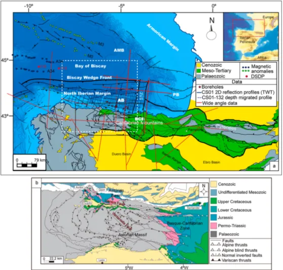
Figure 2. Geological context of the studied zone; (a) Location map of the studied area within the context of the Bay of Biscay and the Pyrenean-Cantabrian orogen, displaying the distribution of the data set used. Based on Alonso et al. (1996), Fernández-Viejo et al. (2012), Roca et al. (2011), Thinon et al. (2001), and Tugend et al. (2014). The white dashed rectangle delineates the studied zone. Magnetic anomalies are from Sibuet et al. (2004). Mesozoic basins: AB: Asturian Basin, BCB: Basque-Cantabrian Basin; PB: Parentis Basin, AMB: Armorican Basin. Structures: STZ: Santander Transfer Zone. The black rectangle delineates the area displayed in detail in Figure 2b. (b) Structure and distribution of the Mesozoic outcrops in the Cantabrian Mountains. After Cadenas and Fernández-Viejo (2018) and Pulgar et al. (1999).
Using a dense set of new high-quality 2-D seismic reflection data and boreholes (supporting information), combined with a synthesis of published results from wide-angle seismic data (Figure 2), we present a detailed map of the rift domains focused on the central and western North Iberian margin and also including the onshore western Cantabrian Mountains. Our work builds on the method developed and applied by Tugend et al. (2014) and Tugend, Manatschal, Kusznir, and Masini (2015). Based on this more detailed mapping, we aim to constrain further how rift architecture conditioned the subsequent compressional reactivation that led to the development of the present-day structure. Moreover, we add some more insights to comprehend the margin segmentation resulting from polyphase rifting and the subsequent compressional reactivation.
2. Tectonic Setting
The structure of the North Iberian margin resulted from successive tectonic events linked to the complex paleographic evolution of the Iberian domain since the Permian. This margin developed during polyphase Triassic to Lower Cretaceous transtensional and extensional rift events and was subsequently reactivated during Alpine orogeny (e.g., Boillot et al., 1971; Derégnaucourt & Boillot, 1982; Malod et al., 1982; Montadert et al., 1971). The obliquity between the main rift directions, the trend of the oceanic spreading center, and the direction of the later compression (e.g., Boillot et al., 1971; Derégnaucourt & Boillot, 1982; Jabaloy et al., 2002; Jammes et al., 2009; Rosenbaum et al., 2002; Vergés & García-Senz, 2001) permitted the preservation of the different stages of an almost complete orogenic cycle.
2.1. Mesozoic Extension: The Bay of Biscay Rift
The Iberian rift systems (Salas & Casas, 1993; Salas et al., 2001; Tugend, Manatschal, & Kusznir, 2015; Vergés & García-Senz, 2001) developed during Mesozoic transtension/extension linked to the formation and propaga-tion of the Atlantic and Tethys oceans and the development of the European-Iberian plate boundary. It is widely agreed that the Bay of Biscay formed as a branch of the southern North Atlantic rift system (Malod & Mauffret, 1990; Roest & Srivastava, 1991; Ziegler, 1988). Offshore, thefingerprints of the Mesozoic extension are preserved within the structure of the North Iberian and the North Biscay conjugate margins (e.g., Boillot et al., 1971; Fernández-Viejo et al., 2011; Montadert et al., 1971; Riaza, 1996; Roca et al., 2011; Thinon et al., 2003) (Figure 2a). Onshore, within the Pyrenean-Cantabrian realm, Mesozoic remnants extensively outcrop in the Pyrenees (e.g., Jammes et al., 2009; Lagabrielle et al., 2010; Teixell, 1998; Vergés et al., 1995) and in the Basque-Cantabrian Zone, in the eastern Cantabrian Mountains (e.g., Espina, 1997; Quintana, 2012). In con-trast, in the Asturian Massif, in the western Cantabrian Mountains, Mesozoic outcrops are very limited (Virgili et al., 1971) (Figures 2a and 2b).
2.1.1. The Post-Variscan Wrench Cycle and Permo-Triassic Rift
During the Stephanian to early Permian, a tectono-magmatic wrench cycle, responsible for a major system of shear zones along the northern Iberian domain, developed during the post-orogenic collapse of the Variscan orogen (Matte, 1991; Ziegler, 1988; Ziegler & Dèzes, 2006). In the Cantabrian Mountains, three main sequences, including continental deposits from the Gzhelian to the Lower Permian, have been recognized (Martínez-García, 2004). An early Triassic rift has been suggested based on the presence of Permo-Triassic sedimentary sequences onshore in northwestern Iberia (e.g., Espina, 1997; Martínez-García, 1983; Pieren et al., 1995; Suárez-Rodríguez, 1988) (Figure 2b). NW-SE and NE-SW structures controlled the structure of grabens and the half-grabens developed during this period (Espina, 1997; García-Mondéjar et al., 1986; Lepvrier & Martínez-García, 1990; Suárez-Rodríguez, 1988). Zamora et al. (2017) defined the offshore Asturian Basin as a Permo-Triassic pre-rift salt basin developed during an early stage of crustal stretching. Following the Permo-Triassic rift, a period of thermal subsidence affected the northern Iberian rifts during the Lower and the Middle Jurassic, leading to a general transgression and the development of characteristic mar-ine facies that are progressively younger from west to east (González-Fernández et al., 2014; Quintana, 2012; Riaza, 1996). These sediments, including dolomites, limestones, and calcareous claystones, have been inter-preted as part of the pre-rift units imaged in the Basque-Cantabrian Basin and in the Asturian Basin (e.g., Cadenas & Fernández-Viejo, 2017; Espina, 1997).
2.1.2. The Late Jurassic to Early Cretaceous Hyperextension Processes
From the Late Jurassic to the Early Cretaceous, rifting processes in the southern North Atlantic rift system evolved progressively from south to north, leading to mantle exhumation and to the northward propagation and opening of the Southern North Atlantic ocean (e.g., Dean et al., 2000; Malod & Mauffret, 1990; Pitman &
Talwani, 1972; Péron-Pinvidic et al., 2007; Sibuet et al., 2007; Srivastava et al., 2000; Tucholke et al., 2007). A major rifting event developed in the northern Iberian rift systems during this period (e.g., Boillot et al., 1979; Derégnaucourt & Boillot, 1982; García-Mondéjar, 1996; Montadert et al., 1971; Tugend et al., 2014). The strain partition that governed the polyphase extension led to the formation of strongly seg-mented rift systems, including disconnected hyperextended basins separated by N-S transfer zones (Jammes et al., 2009; Tugend, Manatschal, & Kusznir, 2015). Afirst event of hyperextension occurred from the Barremian/Valanginian to the Aptian in the Bay of Biscay rift system and was overprinted by a sec-ond event, which was better recorded in the Pyrenean-Basque-Cantabrian rift system, where these pro-cesses spanned from the Aptian to the Early Cenomanian (Jammes et al., 2009; Tugend et al., 2014). In the Bay of Biscay rift, hyperextension processes included crustal thinning and mantle exhumation (Tugend et al., 2014). During this period, the Armorican Basin (Montadert et al., 1971; Thinon et al., 2002), the Asturian Basin (Boillot et al., 1979; Cadenas & Fernández-Viejo, 2017; Riaza, 1996) and the Parentis Basin (Bois et al., 1997; Ferrer et al., 2008; Jammes et al., 2010; Pinet et al., 1987) developed as major rift basins (Figure 2a). Tugend, Manatschal, Kusznir, and Masini (2015) interpreted the Parentis Basin as rift basin developed on top of a hyperthinned domain and defined a syn-hyperextension unit spanning from the Valanginian to the Aptian. In the Armorican Basin, Thinon et al. (2002, 2003) inter-preted the emplacement of an allochthonous unit on top of exhumed basement during the Aptian. In the Asturian Basin, Cadenas and Fernández-Viejo (2017) interpreted a syn-rift unit spanning from the Late Jurassic to the Barremian.
In the Aptian, the reorganization of the African and European plates (Rosenbaum et al., 2002) led to a complex stressfield and the counterclockwise rotation of the Iberian plate (Gong et al., 2008) and related movements between neighboring short-lived microplates (Vissers & Meijer, 2012). This complex geody-namic evolution, together with the uncertainties about the origin and the age of M-series magnetic anomalies, has led to a long-lived controversy between plate kinematic and geological models concerning the rotation and the position of Iberia from the Late Jurassic to the Early Cretaceous (Barnett-Moore et al., 2016).
2.1.3. Seafloor Spreading Within the Bay of Biscay and Thermal Subsidence in Adjacent Rift Basins
The evolution of lithospheric breakup in the southern North Atlantic and the precise age of formation of the first oceanic crust in the Bay of Biscay are disputed. This is mainly because of the uncertain nature and age of the oldest linear magnetic anomalies attributed to the M-series along the Iberia-Newfoundland margin (e.g., Bronner et al., 2011; Nirrengarten et al., 2017; Sibuet et al., 2007). In the Bay of Biscay, such anomalies have been identified (Roest & Srivastava, 1991; Sibuet et al., 2004) (displayed in green in Figure 2a), and further works showed that they fall onto thinned continental crust and exhumed mantle (Thinon et al., 2003; Tugend et al., 2014). The Bay of Biscay V-shaped oceanic basin has been interpreted to develop during a short-lived Mid-Cretaceous (Latest Aptian to Albian) to Late Cretaceous (Campanian) seafloor spreading epi-sode (Sibuet et al., 2004; Sibuet & Collette, 1991). The A34 magnetic anomalies are the only anomalies that are widely recognized and accepted as oceanic anomalies (Sibuet et al., 2004; Srivastava et al., 1990) (displayed in blue in Figure 2a). Basaltic rocks interpreted as oceanic crust were drilled at Deep Sea Drilling Project Site 118 (Laughton et al., 1972) (Figure 2a).
During this time span, a major period of thermal subsidence governed the evolution of the Asturian and the Parentis Basin in the North Iberian margin, where early stages of diapir emplacement occurred, and the Armorican Basin, in the northern Bay of Biscay margin (Cadenas & Fernández-Viejo, 2017; Ferrer et al., 2008; Thinon et al., 2002; Tugend, Manatschal, Kusznir, & Masini, 2015). In the Asturian Basin and in the Armorican Basin, the breakup unconformity has been ascribed to the Aptian (Cadenas & Fernández-Viejo, 2017; Thinon et al., 2002).
2.2. The Compressional Reactivation of Rift Systems and the Development of the Pyrenean-Cantabrian Orogen
The prevailing extensional stressfield was modified by the onset of the collision between the Iberian and the European plates in the Late Cretaceous. This collision lasted until the early Miocene (Vergés et al., 2000). At that time, the Iberian-European plate boundary became inactive and Iberia was incorporated into the European plate (Roest & Srivastava, 1991). During the Alpine orogeny, the Bay of Biscay and the Basque-Cantabrian rifts were reactivated to various extent, generating the present-day
Pyrenean-Cantabrian orogen. North Iberia is classically interpreted to show from west to east a transition between inci-pient oceanic underthrusting/proto-subduction and complete continent-continent collision (the Pyrenees) (e.g., Álvarez-Marrón et al., 1996; Boillot et al., 1979; Choukroune & ECORS Team, 1989; Fernández-Viejo et al., 1998; Roca et al., 2011). A crustal root developed beneath the collisional chain is well-known in the Pyrenees (Gallart et al., 1981; Choukroune & ECORS Team, 1989) and extends westward, although much smaller, within the Basque-Cantabrian Zone (Pedreira et al., 2003, 2007) and beneath the summits of the Cantabrian Mountains (Fernández-Viejo et al., 2000; Pulgar et al., 1996; Ruiz, 2007).
During the Alpine compression, the North Biscay margin underwent minor tectonic reactivation (Thinon et al., 2001). In contrast, its conjugate to the south, the North Iberian margin, exhibited various stages of inver-sion due to thefinal docking of Iberia to Europe. Most of the compression offshore was accommodated through the formation of an accretionary wedge, now buried at the northern front of the continental slope (Álvarez-Marrón et al., 1997; Fernández-Viejo et al., 2012; Gallastegui et al., 2002) and the southward under-thrusting of a part of the distal domain beneath the platform (Fernández-Viejo et al., 2012; Roca et al., 2011). The underthrusting led to crustal thickening and the uplift of the Cantabrian Mountains (Alonso et al., 1996; Fernández-Viejo et al., 2000; Pedreira et al., 2003; Pulgar et al., 1996) (Figure 2a). Meanwhile, the Asturian Basin and the Parentis Basin within the continental platform were slightly reactivated through the mild inver-sion of the main normal faults, the development of related folds, and the squeezing of diapiric structures (Cadenas & Fernández-Viejo, 2017; Ferrer et al., 2008; Gallastegui et al., 2002). Age-dated syn-orogenic units have been ascribed to the Middle Eocene to Lower Miocene within the accretionary wedge (Álvarez-Marrón et al., 1997), to the Upper Cretaceous to Middle Miocene in the Parentis Basin (Ferrer et al., 2008) and to the Upper Eocene to Lower Miocene in the Asturian Basin (Cadenas & Fernández-Viejo, 2017; Gallastegui et al., 2002).
Gallastegui et al. (2002) and Pedreira et al. (2015) estimated 96–98 km of shortening from the restoration of a complete section through the Cantabrian Mountains and the central part of the North Iberian margin. Further, east, within the Basque-Cantabrian Zone and the Parentis Basin, Quintana et al. (2015) calculated 122 km of shortening. In the Parentis Basin, the pre-Cretaceous restoration proposed by Vergés and García-Senz (2001) involves little inversion. In the eastern part of the collisional chain, in the Pyrenees, vari-able shortening values have been estimated ranging from 80 km to 147 km (e.g., Mouthereau et al., 2014; Muñoz, 1992; Teixell, 1998; Teixell et al., 2016; Vergés et al., 1995).
2.3. The Asturian Basin as a Major Rift Basin and the Mesozoic Fossil Remnants Onshore in the Western Cantabrian Mountains
The offshore Asturian Basin has been interpreted as a mildly inverted asymmetric rift basinfilled by a sedi-mentary sequence including sediments from the Triassic to the Quaternary (Boillot et al., 1979; Cadenas & Fernández-Viejo, 2017; Gallastegui, 2000; Riaza, 1996). Cadenas and Fernández-Viejo (2017) interpreted a deep E-W basin bounded southward by a major north dipping normal fault and estimated its depth at the main depocenter as more than 10 km. In the southernmost continental platform of the central North Iberian margin, several exploration boreholes were drilled (Cadenas & Fernández-Viejo, 2017; Gutiérrez-Claverol & Gallastegui, 2002; Lanaja, 1987). Sediments recovered by boreholes include Carboniferous sandstones and limestones, Triassic anhydritic red clays, and sandstones belonging to the Keuper facies, with Muschelkalk limestones interbedded. The Lower Jurassic sediments include Hettangian dolomites and limestones and Liassic limestones. The Upper Jurassic to Lower Cretaceous heterogeneous siliciclastic units represent the thickest deposits. The Upper Cretaceous corresponds to turbiditic deposits that are unconform-ably overlain by Tertiary continental deposits, including sediments with ages ranging from the Palaeocene to the Lower Miocene.
Onshore, the Asturian Basin is also known as Gijón-Villaviciosa Basin and crops out near the coast, including sediments from the Permian to the Upper Cretaceous (e.g., Uzkeda et al., 2016; Valenzuela et al., 1986) (Figure 2b). Continental deposits with volcanic elements constitute the Permian (Martínez-García, 1981; Suárez-Rodríguez, 1988; Wagner & Martínez-García, 1982). Muschelkalk carbonates from the Middle Triassic are very restricted or absent (Robles & Pujalte, 2004; Tejerina & Vargas, 1980). Upper Triassic sediments include claystones and siltstones, with gypsum and evaporites, and dolomites and limestones in the upper part, corresponding to Keuper facies (Pieren et al., 1995; Suárez-Rodríguez, 1988). NW-SE and NE-SW syn-sedimentary faults controlled the Permo-Triassic sedimentation in this basin (Martínez-García, 1983;
Suárez-Rodríguez, 1988). The most relevant structure within this family is the Ventaniella fault (Figure 2b). This fault has been interpreted onshore as a polyphase structure that could date from the initial post-Variscan reorganization of the Iberian massif (Julivert et al., 1971; Matte, 1991). Offshore, this structure, also referred to as Cantabrian fault, has been mapped traditionally to follow the trace of the Avilés canyon (Boillot et al., 1973; Derégnaucourt & Boillot, 1982; Martínez-Álvarez, 1968). Recently, Fernández-Viejo et al. (2014) interpreted this fault as a major structure that separates two distinctive crustal domains with different seismic activity. These authors proposed a new submarine location for this structure, running N60°W. The Lower to Middle Jurassic sediments correspond to a well-known marine sequence, which includes dolomites and limestones, displaying a maximum thickness of about 600 m (González-Fernández et al., 2014; Valenzuela et al., 1986). The Upper Jurassic sediments include continental deposits linked to a second rift event, and shallow marine andfluvial deposits developed during the Kimmeridgian-Tithonian transgressive event (González-Fernández et al., 2014). From the Tithonian to earliest Barremian, González-Fernández et al. (2014) recognized a period of erosion/non-deposition and defined an Upper Barremian to Aptian transgres-sion accompanied by the deposition of marine facies. The Aptian-Albian and the Upper Cretaceous deposits, corresponding mainly to siliciclastic sediments with some calcareous levels, are very scarce and discon-nected. Locally, these sediments overlie unconformably the Palaeozoic basement (González-Fernández et al., 2004). NW-WNW-E-W faults have been recognized as the main faults conditioning the structure of the Jurassic and the Cretaceous materials (Lepvrier & Martínez-García, 1990; Uzkeda et al., 2016). The E-W trending Llanera Fault is interpreted as the main structure controlling the geometry of the onshore Mesozoic deposits (Alameda & Ríos, 1962) (Figure 2b). This structure was subsequently inverted during the Cenozoic resulting on the uplift of the Mesozoic sediments, which were thrust over the Cenozoic sediments of the Oviedo Basin (Alonso et al., 1996).
3. Methodology and Terminology
3.1. Rift Domain Definition
We followed the rift domain definition proposed by Tugend, Manatschal, Kusznir, and Masini (2015). These authors define five structural domain, which are referred to as proximal, necking, hyperthinned, exhumed mantle, and oceanic domains (Figures 1a and 1b).
The proximal domain is characterized by minor lithospheric thinning that results in the formation of classical graben and half-graben basins (Sutra et al., 2013; Tugend, Manatschal, Kusznir, & Masini, 2015) (Figure 1b). The necking domain has been defined as the area where 30 (±5) km continental crust is thinned to about 10 km (Mohn et al., 2012; Péron-Pinvidic & Manatschal, 2009; Sutra et al., 2013) (Figure 1b). The crustal thin-ning results in the creation of accommodation space, recorded by progressive thickethin-ning of the synrift sequences and deepening of depositional environments, the shallowing of the Moho, and the deepening of the top basement (Tugend, Manatschal, Kusznir, & Masini, 2015). The limit of this domain may correspond to the taper break (Osmundsen & Redfield, 2011) (Figure 1a), which usually coincides with the coupling point (Nirrengarten et al., 2016; Péron-Pinvidic et al., 2013). The coupling point represents the place where the crus-tal deformation changes from a decoupled mode, in which faults sole out in ductile layers in the crust, to a coupled mode, in which faults penetrate across the thinned crust directly into the mantle (Sutra et al., 2013), due to the embrittlement of the crust (Pérez-Gussinyé et al., 2001) (Figures 1a and 1b). The hyperthinned domain is defined as the area where the continental crust is thinned from about 10 km to zero, leading to the development of a substantial amount of accommodation space (Tugend, Manatschal, Kusznir, & Masini, 2015) (Figures 1a and 1b). With further extension, mantle rocks may also be in the exhumed mantle domain (Figure 1a). Anomalous seismic velocity structures have been interpreted to indirectly indicate the presence of serpentinized mantle at many magma-poor rifted margins (e.g., Dean et al., 2000; Minshull, 2009). Local magmatic additions, continental-derived extensional allochthons, serpentinized mantle rocks, locally reworked in syntectonic breccias, and sag-type basinsfilled by thick aggradational and progradational sequences that wedge out oceanward, are also typical features of this domain (Tugend, Manatschal, Kusznir, & Masini, 2015) (Figure 1a). Finally, the establishment of stable oceanic spreading and the presence of seafloor-spreading magnetic anomalies characterize the oceanic domain. The landward limit of this domain remains strongly debated owing to the gradational character recently attributed to breakup (Péron-Pinvidic & Manatschal, 2009) and the uncertainties in the interpretation of magnetic anomalies within ultra-distal rifted margins (Nirrengarten et al., 2017; Sibuet et al., 2007).
3.2. Mapping Approach
We have characterized the rift domains in the central and western North Iberian margin following the approach developed by Tugend et al. (2014) and Tugend, Manatschal, Kusznir, & Masini (2015). The main assumption behind approach is that in magma-poor, thermally equilibrated rifted margins, the creation of accommodation space (given by the rift-related deposits) can be considered as afirst-order proxy for crustal thickness (Figure 1b). Because the compressional reactivation that affected the North Iberian margin was superimposed on the rift structures, the application of this methodology is challenging, particularly where the former margin structures were reactivated and the crust has been thickened (Fernández-Viejo et al., 2012; Gallastegui et al., 2002). To overcome this challenge, our interpretations relied on the following aspects: (1) crustal structure, crustal thickness, and type of extensional setting (high versus low betta setting,
Figure 3. Representative time migrated seismic reflection lines crossing the North Iberian margin at three different longitudes, showing the seismic interpretation of the main structures, thefirst-order interfaces and, on top, the interpreted rift domains. (a) CS01-108 seismic line at the westernmost area, (b) CS01-133 section at the central part of the margin, and (c) CS01-142 seismic profile located in the easternmost part of the studied zone. The seismic Moho and the presence of anomalous mantle velocities (Vp< 8 km/s) have been estimated using the velocity models of Ayarza et al. (1998), Fernández-Viejo et al. (1998, 2012), and Ruiz (2007). The inset map shows the location of the reflection lines within the seismic data set (red). The map also displays the Moho depth and the distribution of the wide-angle profiles used to estimate its position. IAM-12 profile, displayed in pink, ESCIN-3.1, shown in green, and ESCIN-4, delineated with a dashed black line, are from Fernández-Viejo et al. (1998); ESCIN-3.3, displayed in black, is from Ayarza et al. (1998); MARCONI profiles, shown in yellow (MARCONI-1 and MARCONI-6 from west to east, and MARCONI-4 and MARCONI-8 from north to south), are from Ruiz (2007). CF: Cantabrian fault from Fernández-Viejo et al. (2014). F1 to F5 faults in the Asturian Basin from Cadenas and Fernández-Viejo (2017). The uninterpreted version of the three seismic profiles is provided as supplementary information (Figure S1).
Figure 1); (2) total accommodation space (between sea level and top basement) and specifically rift-related stratigraphic architecture; and (3) nature of top basement (stratigraphic or tectonic) and present-day structural boundaries of the domain (extensional fault, inverted fault, thrust).
We use the CS01 dense set of commercial 2-D multichannel reflection profiles of a high quality, obtained from the National Hydrocarbon Archive of Spain as time migrated stacks. We interpretedfive E-W seismic profiles and 38 N-S seismic lines, together with 22 boreholes (Figure 2). Cadenas and Fernández-Viejo (2017) provide the acquisition and the processing parameters as well as a description of the quality of the seismic records (supporting information, Tables S1 and S2). One of the longest N-S profiles that
Figure 4. CS01-132 depth-migrated seismic reflection profile. The seismic line runs from the Cantabrian Platform to the Biscay Abyssal Plain, crossing the central part of the Asturian Basin and the Le Danois High. Thefigure shows the seismic interpretation of the major structures and the first-order interfaces, illustrating the crustal architecture, and the interpreted rift domains on top. A column with the migration velocities is shown at the left, with the depths of the main interpreted surfaces. SF: seafloor; TSB: top seismic basement; RM: refraction Moho. The vertical line between SP 900 and 1000 shows the profile where the velocity column has been extracted. The inset shows the location of the depth-migrated profile and the wide-angle sections used to estimate the Moho depth. ESCIN-4 from Fernández-Viejo et al. (1998); MARCONI-1 from Ruiz (2007).
extends out for 107 km from the continental platform to the abyssal plain (CS01-132) (Figure 2) was post-stack depth migrated.
Seismic interpretation of thefirst-order interfaces allowed the definition of the crustal structure. We mapped five primary interfaces within the studied area to define the crustal scale architecture and the accommo-dation space (Figures 3 and 4): the seafloor, the base of the syn-orogenic deposits, the base of the post-hyperextension sediments, the top of the seismic basement, and seismic Moho. If the top of seismic basement corresponds to the base of sedimentary infill, these five interfaces enable us to define variations in crustal and sediment thickness of the rift-related deposits and the syn-orogenic deposits. In the central part of the North Iberian margin, the seismic Moho is not traceable, so we interpreted this interface from the integration with previous seismic velocity models from the ESCI-N and the MARCONI projects. We used IAM-12, ESCIN-3.1, and ESCIN-4 models from Fernández-Viejo et al. (1998); the ESCIN-3.3 model from Ayarza et al. (1998); and the MARCONI-1, MARCONI-6, MARCONI-4, and MARCONI-8 models from Ruiz (2007) (see inset in Figure 3). We have used these models to determine the two-way travel time of the Moho interface. The time conversion was gridded, and the resulting data were extrapolated and superimposed on to the seismic sections (Figures 3 and 4).
Interpretation of the main seismo-stratigraphic sequences and the major structures allowed the definition of the stratigraphic architecture (Figure 5). These seismo-stratigraphic sequences are then related to the major tectonic events developed within the North Iberian margin as (1) the post-tectonic unit, developed during the passive margin stage; (2) the syn-orogenic and the pre-orogenic units, related to the Alpine orogeny; (3) the post-hyperextension, syn-hyperextension, and pre-hyperextension units, linked with the main rifting event; and (4) the seismic basement. A detailed description of the seismic facies and the age of these units, as well as the seismic to well ties used to define the time constraints, is provided by Cadenas and
Fernández-Figure 5. Enlargements of three seismic profiles showing the stratigraphic architecture of the main structural areas identified within the central and western North Iberian margin. Exaggerated vertical scale: (a) Line CS01-107, displaying the structure of the rift basin identified in the westernmost continental platform; (b) Profile CS01-133, showing the main structures and seismic sequences identified within the central part of the Asturian Basin; and (c) Line CS01-132, in the central North Iberian margin, displaying the structure of the accretionary wedge developed in the abyssal plain (modified from Cadenas & Fernández-Viejo, 2017). Age of the pre-orogenic, the syn-orogenic, and the post-orogenic deposits within the accretionary wedge from Álvarez-Marrón et al. (1997) and Fernández-Viejo et al. (2011). The uninterpreted version of the seismic profiles is provided as supporting information (Figure S2).
Viejo (2017). A 3-D analysis based on some boreholes allowed us to constrain the spatial variation of sediment thickness interpreted as part of the syn-orogenic and syn-hyperextension and post-hyperextension units (Figures 6 and 7). We represented the well records in terms of tectonic units after analyzing the stratigraphic reports and defining the main seismo-stratigraphic units from the development of seismic to well ties and the correlation of the time constraints noted in the boreholes with the seismic facies observed within the seismic profiles.
Isopach maps developed from thefirst-order interfaces provided further constraints on local and regional changes in crustal and sedimentary thickness (Figures 8 and 9). To build these maps, we gridded the seafloor and the top of the seismic basement interpreted from the seismic data and the time-converted seismic Moho from all the available velocity models. Using these surfaces and the CS01 migration velocities, we developed a velocity model and we depth converted the top of the seismic basement and the seafloor. From the com-bination of the resulting basement interface and the gridded refraction Moho in depth, we developed a crus-tal thickness map (Figure 8). The subtraction of the depth converted top of the seismic basement and the depth converted seafloor defined the sediment thickness variations (Figure 9). Mapped crustal and sedimen-tary thicknesses also include the effects of inversion and crustal thickening during convergence. Thus, the present-day value of crustal thickness represents an upper limit that locally reflect crustal thickening of pre-viously extended crust due to reactivation.
Since the North Iberian margin is now, albeit submerged, part of the Pyrenean-Cantabrian orogen, our ana-lysis of rift domains had to include the onshore Cantabrian Mountains to understand better the influence of rift inheritance on the margin inversion. Onshore, rift domains are mapped based mainly on the analysis of the crustal thickness obtained from published wide-angle/refraction P wave velocity models (Figure 10). We used the models developed for the westernmost area from Córdoba et al. (1987) and Tellez (1993), the IAM-12 and ESCIN-4 profiles, Profiles 1–5 from Fernández-Viejo et al. (1998, 2000), Profiles 1 and 6 from Pedreira et al. (2003), and the MARCONI-1 profile from Ruiz (2007) (see inset in Figure 10).
Figure 6. Lithologies, time constraints, and tectono-stratigraphic correlations along four representative boreholes drilled within the platform around the studied zone. The definition of the tectono-stratigraphic units has been developed using seismic to well ties from which we assigned ages to the interpreted seismic units. Borehole Galicia-B2, representative of the proximal domain; Mar Cantábrico K1, representative of the necking area; and Mar Cantábrico H1X and Mar Cantábrico M1 showing the thick sequences from the hyperthinned domain; Mi: Miocene; Ol: Oligocene; Eo: Eocene; Pal: Palaeocene; Ce: Cenomanian; Al: Albian; Ap: Aptian; Ba: Barremian; Ht: Hauterivian; Va: Valanginian; Be: Berrasian; Ki: Kimmeridgian; Neo: Neocomian; Pu: Purberk; Li: Lias; Ra: Raethian; He: Hettangian; Ke: Keuper; Mu: Muschelkalk; Ca: Carboniferous; Tr: Triassic; Pa: Palaeozoic.
4. Structure and Characterization of Rift Domains in the Central and Western North
Iberian Margin
The interpretation of the seismic profiles and the boreholes has revealed broad structural variability within the margin (Figures 3–5). From the interpretation of the first-order interfaces and the main structural and stra-tigraphic features, we have distinguished four distinct areas: (1) a synclinal basin developed on top of thick crust, within the continental platform of the western North Iberian margin (Figures 3a and 5a); (2) the deep and wide Asturian Basin overlying a highly attenuated crust, in the continental platform of the central North Iberian margin (Figures 3b and 3c, 4, and 5b); (3) the Le Danois High basement block, within the shelf-break and the continental slope in the central North Iberian margin (Figures 3b and 3c and 4); and (4) the accretion-ary wedge within the abyssal plain (Figures 4 and 5c)
4.1. Crustal Structure: Seismic Interpretation of First-Order Interfaces
The seafloor reflection varies from 200 ms TWT on the shelf to 5,800 ms TWT in the abyssal plain. It is flat in the central continental platform but shows a low, deepening to 1.2 s TWT in the deepest part of the Asturian Basin (Figure 3b). On the continental slope and around the Santander, Torrelavega, Llanes, Lastres, Gijón, and Avilés major submarine canyons, the bathymetry is largely controlled due to the abundance of mass-wasting processes and canyon deposits (Ercilla et al., 2008).
The base of the syn-orogenic deposits can be recognized in the central North Iberian continental platform, where it is well imaged by a regional erosional truncation, which represents an onlap surface toward the limbs and the hinge of the anticlines (Figures 3b, 4, and 5b). This surface is irregular and draws the shape of the Alpine folds beneath the bathymetric low recognized in the Asturian Basin. It deepens to 2 s TWT toward the synclines (e.g., Figure 5b, between 25 and 30 km of distance) and shallows to 1 s TWT toward the hinge of the anticlines (e.g., Figure 5b, between 30 and 40 km of distance). In the southernmost part of the continental platform, this surface displays a fan-shape geometry, deepening to 2.5 s TWT in the so-called Peñas Trough (e.g., Figure 3b, between SP 0 and 100). Over the hinge of the anticline developed in the hanging wall, this surface shallows to 0.3 s TWT (e.g., Figure 3b, SP. 150 to 200). Within the abyssal plain, this surface can be followed between 7 and 8 s TWT in the frontal and central part of the accretionary wedge
Figure 7. 3-D view of nine representative boreholes drilled in the Asturian Basin showing thickness variations of the main tectono-stratigraphic units along the whole area. The stratigraphic information has been taken from the well reports. See Lanaja (1987), Gutiérrez-Claverol and Gallastegui (2002), and Cadenas and Fernández-Viejo (2017) for stratigraphic col-umns. We defined the main seismo-stratigraphic units displayed along the boreholes based on seismic to well ties. This figure is provided on a larger scale as supporting information (Figure S3).
(Figures 4 and 5c). At the toe of the slope, this surface cannot be identified confidentially due to complex reflectivity patterns (Figure 4, between SP. 2100 and 2500). It constitutes a planar onlap surface in the frontal part of the accretionary wedge and a wavy baselap surface in the northernmost thrust sheet (Figure 4, between SP. 2500 and 3100).
The base of the post-hyperextension sediments our third interface in the continental platform, can be recog-nized between 2 and 4 s TWT within the depocenters of the Asturian Basin, where it is defined by an unconformity that passes laterally to a correlative conformity (Figure 3b, between SP 300 and 450). In this area, this surface is folded and cut by the inverted faults (e.g., Figure 3b, between SP.500 and 700). Within the southern part of the continental platform, the poor quality of the seismic record hampers its recogni-tion in some seismic secrecogni-tions (Figure 3b, southward of SP 100). Therefore, we used data from boreholes to estimate its position at about 3 s TWT (Cadenas & Fernández-Viejo, 2017). In the northern part of the con-tinental platform and in the eastern part of the Asturian Basin, the distinctive reflection fabric of the parallel-layered post-hyperextension unit and the poorly reflective syn-hyperextension unit, together with the local toplap geometry of the syn-hyperextension sediments, have been used to map this interface (Figure 3b, between SP 800 and 1300, and Figure 3c, respectively). In the eastern part of the Asturian
Figure 8. Crustal thickness and main faults in the central and western North Iberian margin. (a) Map of isolines resulting from subtracting the sediment thickness from the actual crustal thickness, based on the depth-convertedfirst-order interfaces interpreted in this study (residual crustal thickness, RCT). F1, F2, F3, and F4 faults from Cadenas and Fernández-Viejo (2017). Offshore trace of the Ventaniella fault from Fernández-Viejo et al. (2014). The yellow points represent locations where granulites have been recovered (Capdevila et al., 1980; Fügenschuh et al., 2003; Malod et al., 1982). The map shows the location of the sections displayed in Figures 8b and 8c. (b) Section illustrating crustal thickness variations in the western North Iberian margin along the CS01-107 seismic profile. (c) Section showing crustal thickness variations in the central North Iberian margin along the CS01-132 seismic line. Identified rift domains are displayed on top of the sections. (d) Rift domain boundaries superimposed on the residual crustal thickness map. The RCT map shows more clearly, once the sediments are subtracted, the boundaries of the rift domains, bearing in mind that in some areas, the crust has been thickened during the Alpine compression.
Basin, this surface is located between 3 and 4 s TWT and affected by the Alpine structures (e.g., Figures 3c, between SP. 2100 and 800). In the northern part of the platform, this planar and south directed surface progressively shallows to less than 1 s TWT over the Le Danois High. In the western North Iberian platform, it could be assigned to a local planar unconformity overlying the pre-hyperextension deposits at about 0.3 s TWT (Figures 3a and 5a).
Figure 9. Sediment thickness within the central and western North Iberian margin. (a) Map of isolines showing thickness variations of the sedimentary cover, based on the depth-convertedfirst-order interfaces interpreted in this study. The map shows the location of the sections displayed in Figures 9b and 9c. (b) Section illustrating sediment thickness variations in the western North Iberian margin along the CS01-107 seismic profile. (c) Section showing sediment thickness variations in the central North Iberian margin along the CS01-132 seismic line. Interpreted rift domains are displayed on top of the sections.
Figure 10. Isopachs map of the crust-mantle boundary onshore showing the Moho depth along the Cantabrian Mountains based on published refraction/wide-angle reflection profiles. The dots reflect the segments of the profiles where good control by PmP/Pn phases was achieved in the refraction models. We used these segments to map the crust-mantle boundary displayed in thefigure. The inset shows the distribution of the velocity models from which the Moho was gridded and contoured. Galicia survey lines delineated with dashed black lines from Córdoba et al. (1987) and Tellez (1993); ESCIN-3.1 and ESCIN-4 profiles, IAM-12 section, and Profiles 1-5 are from Fernández-Viejo et al. (1998, 2000); Profiles 1 and 6 from Pedreira et al. (2003); and MARCONI-1 section from Ruiz (2007). CMF: Cantabrian Mountains Front from Alonso et al. (1996). SPF: South Pyrenean Front.
The top of seismic basement can be reasonably well constrained. In the central part of the margin, where the rift-related sequences and the syn-orogenic deposits filling the Asturian Basin can be differentiated (Cadenas & Fernández-Viejo, 2017), this horizon has been interpreted at the base of the pre-hyperextension unit (Figures 4 and 5b). This planar surface deepens to 6 s TWT of depth at the main depocenter of the Asturian Basin (e.g., Figure 3c, around SP. 1200) shallowing to 3–4 s TWT in the southernmost continental platform and to less than 0.5 s TWT toward the Le Danois High (e.g., Figure 3b, around SP. 100 and 1400, respectively). In the western sector of the study area, where boreholes are very scarce, we map a planar top basement at the base of the undifferentiated sedimentary infill. This surface is located at about 1 s TWT in the shelf break and shallows progressively toward the south, reaching less than 0.3 s TWT (Figure 3a). This surface draws locally a low at about 3 s (TWT) at the central part of the platform (Figure 3a). The top basement on the continental slope is shallow, as suggested by the recovering of basement samples previously described on the northern slope of Le Danois High (Boillot et al., 1979; Gallastegui et al., 2002). The steepness, the abrupt change in water depths, and the abundance of mass-wasting deposits hamper interpretation due to the resulting chaotic seismic character. However, intra-basement reflections were distinguished (Figures 3 and 4). Within the abyssal plain, the top of the seismic basement has been interpreted in previous studies as corresponding to the base of Upper Cretaceous pre-orogenic deposits within the accretionary wedge (Fernández-Viejo et al., 2011; Roca et al., 2011). In the new seismic dataset, we have identified a deeper folded and thrust top of the seismic basement in the central part of the North Iberian margin (Figure 4) where the accretionary wedge is bet-ter developed (Fernández-Viejo et al., 2012). This surface can be traced with confidence at about 9–10 s TWT in the frontal part of the thrust sheets (Figure 5c). In the western part of the North Iberian margin, the accretionary wedge is narrow and less developed (Álvarez-Marrón et al., 1997; Fernández-Viejo et al., 2012). At these longitudes, the seismic fabric of the thin sedimentary record sometimes displays similar patterns to those observed within the underlying basement (Figure 3a), making it difficult to define the boundary between the two units.
Finally, the Moho is the deepest horizon used, and it is not always conspicuous in the reflection profiles. Its low amplitude in the central part of the margin (Álvarez-Marrón et al., 1996; Cadenas & Fernández-Viejo, 2017; Fernández-Viejo et al., 2011; Pulgar et al., 1996) has been attributed to a reduced contrast in velocities between the lower crust and the upper mantle (Fernández-Viejo et al., 1998; Ruiz, 2007), probably due to the serpentinization of uppermost mantle rocks now underthrust beneath the slope and the platform (Fernández-Viejo et al., 2012; Roca et al., 2011). The grid developed from the integration of the published refraction models defines a planar surface located at about 9.5 s TWT in the western North Iberian platform, deepening to 11 s TWT in the northern part of the seismic profiles (Figure 3a). In the central North Iberian margin, Moho is at 9.5 s TWT in the continental platform. It shallows to 8–9 s TWT beneath Le Danois High and deepens again along the continental slope, reaching 12 s TWT at the northernmost part of the seismic profiles (Figures 3b and 5c).
4.2. Spatial Variations of Crustal and Sediment Thickness
Figures 8 and 9 show isopach maps of the residual crustal thickness (RCT) and sediment thickness, respec-tively. The observed trends depict the existence of distinctive domains resulting from different modes of deformation within the two segments.
In the western segment of the North Iberian margin, RCT contours trend in a NW-SE direction. The continental platform area corresponds to a domain of thicker RCT, with values decreasing from 28 km to 25 km northeast-ward. The<1 km thick sedimentary cover interpreted to be present in this area has a less well-defined trend. Sediment thickness locally reaches a maximum value of about 7 km at the depocenter of the rift basin (Figure 9). This basin overlies thinned RCT with values ranging from 21 km to 24 km. At the foot of the con-tinental slope, RCT is reduced to 12 km. This area of extreme crustal thinning is wide and trends in a NW-SE direction. Within the abyssal plain, data are very sparse but the basement is less than 10 km thick and the sedimentary cover less than 2 km thick.
In the central segment of the North Iberian margin, contours are irregular and short. RCT and sediment isopachs run in a NW-SE direction in the southernmost continental platform, turning into an E-W direction in the Asturian Basin, in the Le Danois High area and in the abyssal plain. In the landward part of the con-tinental platform, the RCT is more than 20 km and typical sediment thickness ranges from 6 to 8 km. RCT
is reduced to less than 15 km beneath the Asturian Basin, where sediments thicken to more than 9 km. At the main depocenter, the basin sediments reach a maximum thickness of 13 km. This deep trough overlies a seismic basement less than 11 km thick. This domain of highly attenuated RCT and the overlying deep trough widen progressively southeastward. The RCT is thicker in the Le Danois High, varying between 20 km and 14 km from west to east. Less than 1 km of sediments are found at the top of the high. RCT is strongly reduced from 20 km to 12 km along the continental slope. In contrast to the western seg-ment of the margin, the RCT thins over a short distance and contours trend E-W direction in this central segment of the margin. Within the abyssal plain, RCT is reduced from 10 km to less than 4 km, with the smallest values at around 5°W (Figure 8), where sediment thickness reaches a maximum value of about 10 km (Figure 9).
The transition between the western and the central segments of the margin regarding the RCT and the sediment thicknesses, and the trends of their contours, occurs between 5°300W and 6°W. This area, strongly modified by the Avilés canyon, shows ill-defined isopach patterns within the continental platform. RCT varies between 15 km and 17 km, and the sedimentary cover seems to thicken. However, sediment thickness is strongly modified by the presence of slope and mass-wasting deposits.
4.3. Basin Architecture, Tectono-stratigraphic Evolution, and Thickness Variations of Rift-Related Deposits
The transition between each structural domain identified along the North Iberian margin reflects major struc-tural and stratigraphic variations. In some areas, major structures can be recognized. The architecture of each domain reveals a tectonic evolution conditioned by strain partitioning in both extensional and compressional settings. Of particular interest is the polyphase evolution of rifting, as shown by the age and the spatial dis-tribution of rift-related deposits. Thickness variations of syn-rift sequences reveal rift-related accommodation space creation, indirectly suggesting variations in the amount of crustal thinning across the margin seg-ments. Different rift stages governed by particular deformation modes can therefore be recognized along the overall area. The occurrence of two rift events and the polyphase evolution of rifting, including progres-sive stages governed by different modes of deformation, complicates the tectono-stratigraphic analysis of the whole margin due to the presence of diachronous seismic sequences. Thus, we refer to rift-related depos-its related to the hyperextension processes that governed the main rift event, having in mind that they may have different ages from west to east across the margin (Figure 5).
4.3.1. The Rift Basin on the Western North Iberian Margin
The westernmost part of the continental platform, west of approximately 6°W, is characterized by the pre-sence of rift basins. A wide unnamed basin, reaching a maximum thickness of about 3 s TWTT, equivalent to about 7,500 m, and a width of about 15 km, stands out (Figures 5a and 9). Two major high-angle normal faults (labeled as FT1 and FT2 in Figure 5a) limit the basin. Although some of the faults show a minor inversion, the majority preserved their extension geometry (Figures 3a and 5a). The main known structure within this area corresponds to the Cantabrian or Ventaniella Fault. This fault is almost vertical and poorly imaged in seismic profiles offshore. Trend variations in the reflections can be used to map this structure (Figure 3a). The location of this structure coincides with the area where the top basement deepens abruptly (Figure 3a).
The basin and the presence of high-angle normal faults is interpreted as related to crustal stretching pro-cesses that caused minor crustal thinning. This interpretation is coherent with the presence of an underlying thick continental crust (Figure 3a).
The sedimentary infill of this basin (Figures 3a and 5a) includes a fan-shaped syn-tectonic unit with onlap geometries that is overlain by aflat unit (Figure 5a). The two units are separated by an unconformity (Figure 5a). The only available borehole in this area, Galicia-B2, located southeast of the main depocenter of this basin (Figure 6) drilled a Palaeozoic basement, ascribed to the Silurian-Devonian, at a depth of 1,1490 m, covered by 108 m of azoic red siltstones, shales, and sandstones, attributed from facies correlation to the Triassic or an older age. The red beds are overlain by 1,056 m of an heterogeneous unit composed by an upper level of sandy mudstones and sandstones, with claystones and siltstone, and limestones containing foraminifera, algaes, and megafossils. Based on the presence of foraminiferal forms like Pseudocyclamina sp., Choffatella sp., Trocholina sp., and Tritaxia sp, and algaes like Mithocodium, these carbonates are dated as Lower Cretaceous, between the Aptian and the Neocomian, in the paleontological report provided with
the well record. This report dated the sandy limestones drilled at the sea bottom as Upper Cretaceous (Cenomanian), relying in the presence of foraminifera like Orbitoling Globotruncana, Globigerina, and Cuncolina,which is also supported by the occurrence of Classopollis, Cyathidites, and Cicatricosisporites among the spores, and dinoflagellates like Hystrichosphaeridium, Systematophora, and Oligosphaeridrium. The possi-bility of a younger age cannot be completely excluded due to the rare occurrence of questionable Operculodinium and Tectatodinium in the palynological samples and Globigerina among the foraminifera. From seismic to well ties, we interpret the main seismo-stratigraphic units, keeping in mind that these units would be much thicker in the main depocenter of the basin, where the sedimentary cover is about 7.5 km thick, than in the area where the well was drilled, recovering 1,489 m of sediments. We included the Triassic deposits drilled in the well record into the fan-shaped unit identified within the seismic records that we interpret as a pre-hyperextension unit (Figure 5a). We cannot exclude the possibility of other younger Mesozoic deposits within this sequence. The Lower Cretaceous sediments, including Aptian deposits, would be part of theflat unit that we interpret as a post-hyperextension unit.
4.3.2. The Hyperthinned Asturian Basin on the Central North Iberian Margin
The continental platform in the central North Iberian margin, east of 5°300W, is occupied by the major Asturian Basin (Figures 3b and 3c, 4, and 5b). The Asturian Basin is imaged as an E-W/ESE-WNW asymmetric rift basin with a maximum sedimentary thickness of about 6 s TWT at its main depocenter (Figures 3b and 3c and Figure 5b), equivalent to about 13.5 km (Figure 4). We interpret this geometry as controlled by two main normal faults that are now inverted (F1 and F2 in Figures 3b and 4, and 5b). The F1 extensional inverted fault appear as the main structure that controlled the morphology of the main depocenter (Figure 9) and the thick-ness of the syn-hyperextension unit (e.g., Figure 4). The F3, F4, and F5 faults could be related to the evolution of the northern part of the basin and the Le Danois High (Figures 3b and 4). The compressional overprint was limited to partial inversion and steepening of the extensional structures, the formation of a few minor reverse faults, together with the development of related growth anticlines affecting the sedimentary cover, and the squeezing of diapirs (Figure 4). The sedimentary record has been divided into six seismic units according to the three main tectonic events developed in the margin (e.g., Boillot et al., 1979; Derégnaucourt & Boillot, 1982) (Figure 5b). From top to bottom, we distinguish (1) the post-tectonic unit, (2) the syn-orogenic unit, (3) the orogenic unit, (4) the post-hyperextension unit, (5) the syn-hyperextension unit, and (6) the pre-hyperextension unit. Underlying these units, we distinguish the seismic basement. The Upper Eocene to Lower Miocene syn-orogenic deposits are much thinner than the rift-related deposits. Overlying the post-hyperextension and pre-orogenic units developed in the Asturian Basin from the Aptian to the Albian and from the Late Cretaceous to the Middle Eocene, respectively, syn-orogenic sediments display onlap geome-tries toward the hinges and the limbs of the growth anticlines, thickening toward the synclines (e.g., Figure 4, between SP. 700 and 1400). The main syn-orogenic depocenter,filled by more than 3,200 m of syn-orogenic sediments, corresponds to the so-called Peñas Trough. This trough, located in the southernmost part of the continental platform, developed in the footwall of the F1 inverted extensional fault (Cadenas & Fernández-Viejo, 2017; Gallastegui et al., 2002) (Figure 4, between SP. 0 and 500).
In the southernmost part of the continental platform, the acoustic basement is interpreted to image a Palaeozoic basement overlain by Triassic sediments (Figure 5b). Borehole Mar Cantábrico-K1 reached a Carboniferous Palaeozoic basement at 3,103 m, overlain by 600 m of Triassic carbonates and claystones with anhydrite (Figure 6). Therefore, we suggest that this area preserves the deposits related to the Permo-Triassic rift and was subsequently overprinted by the major Late Jurassic to Early Cretaceous rift.
The Early to Middle Jurassic pre-hyperextension seismo-stratigraphic unit (Figure 5b) includes Liassic lime-stones, drilled in borehole Mar Cantábrico-K1 (Figure 6). The interpretation of a continuous pre-hyperextension unit overlying the seismic basement defines a stratigraphic contact between the sedimentary cover and the underlying basement (Figure 5b). Nevertheless, in some profiles this unit cannot be recognized clearly so the nature of the top of seismic basement remains uncertain in some places (Figure 3c).
The syn-hyperextension unit is attributed to image the Late Jurassic to the Aptian sediments. It is interpreted in the seismic records as a thick wedge-shaped unit that reaches a maximum thickness of 4.1 s TWT (Figure 3b) equivalent to more than 11 km (Figure 4) at the main depocenter of the Asturian Basin. Boreholes Mar Cantábrico-K1 and Mar Cantábrico-M1 drilled 1,790 m and 2,837 m, respectively, of siliciclastic sediments that we attribute to an heterogeneous synhyperextension unit (Figure 6). The thick syn-hyperextension
sedimentary unit reflects a major event of creation of accommodation space in the Asturian Basin. Figure 7 displays a 3-D view of thickness variations of the main seismic units along the trace of nine representative boreholes. The syn-hyperextension unit thickens toward the east and north (Figure 7). At the main depocen-ter of the Asturian Basin, this unit is 2,256 m thick in borehole Mar Cantábrico- H1X and 2,500 m thick in bore-hole Asturias-D2 (Figures 6 and 7). Within the continental platform, borebore-holes record progressive eastward thickening of the Upper Jurassic to Lower Cretaceous sediments identified as part of the syn-hyperextension unit. In the westernmost part, borehole Asturias E-1 drilled 1,391 m, while at the easternmost part, borehole Mar Cantábrico-M1 recovered 2,244 m.
We interpret the Aptian to Albian sediments as part of the post-hyperextension unit within the Asturian Basin (Figure 5b). Borehole Asturias-D2 drilled 900 m of Aptian to Albian deposits, borehole Mar Cantábrico H1X drilled 1,200 m, while borehole Águila-1 recovered 2,115 m (Figures 6 and 7). The thickness of the Aptian-Albian sediments that we interpret as post-hyperextension deposits suggests major creation of accommoda-tion space related to thermal subsidence of this basin.
The presence of such a thick basin on top of thinned continental crust (Figures 3b and 3c and 4) suggests an extreme crustal thinning. The thick Upper Jurassic to Lower Cretaceous syn-hyperextension unit recorded major tectonic subsidence, supporting this thinning. Thus, the Asturian Basin can be considered as a hyperthinned rift basin formed during a major rifting period spanning from the Late Jurassic to the Barremian. This event overprinted the Permo-Triassic rift event.
4.3.3. The Le Danois Basement Block on the Central North Iberian Margin
The Le Danois High represents a continental block that is thicker than the adjacent basement blocks to the north and to the south (Figures 3b and 3c and 8). The top basement with this block is tilted eastward (Figures 3c and 4). In the seismic profiles located between 5°W and 4°200W, the top basement is interpreted at less than 1 s TWT (Figure 3b). Eastward of 4°200W, the top of the seismic basement is interpreted at about 3 s TWT (Figure 3c). This basement high separates the Asturian Basin from the abyssal basin (Figure 4). This block hosts a small basin, bounded by the F3 and F4 faults (e.g., Figure 4). This basin widens toward the east (Figures 3b and 3c and 9). Flooring this basin, we interpret an unconformity surface that locally truncates the underlying basement reflections (e.g., Figure 3c, around SP. 700, and Figure 4, between SP. 1600 and SP. 1800). The reflections at the bottom part of the sedimentary cover onlap over this basal truncation (e.g., Figure 3b, around SP. 1300). The origin of this unconformity, whether it is exhumation and/or erosion, is dif-ficult to discern because of the lack of borehole data and the difdif-ficulty in correlating the stratigraphy of this area with the main depocenter of the Asturian Basin. The small inner trough is interpreted to be separated from the Asturian Basin by the F2 inverted fault and its related anticline, developed over a faulted horst struc-ture (Figure 4). Reactivation and/or inversion of minor high angle normal faults modified the original rift structure in the southern most part of the block in its western side (Figures 3b and 4).
The sedimentary cover and, particularly, the syn-hyperextension unit thin dramatically toward the Le Danois High (Figure 9). Based on the correlation of the seismic facies with those identified within the Asturian Basin, we interpret the base of the post-hyperextension and the base of the syn-orogenic unit, which define a thin and partially eroded post-hyperextension unit (Figures 3b and 4). This unit underlies an irregular syn-orogenic unit and unconformably overlies a thin syn-hyperextension unit. The thickness of both units increases toward the east (Figures 3b and 3c). The northern slope of the Le Danois High corresponds to the continental slope, and the wavy shape of the reflections suggests the presence of sediments dominated by mass-wasting pro-cesses. (Figure 3b, e.g., between SP 1500 and SP 1800; Figure 3c, between SPs 300 and 100). We interpret some of the mass-wasting deposits to be interbedded within syn-tectonic sequences. Therefore, mass-wasting pro-cesses could be interpreted as related to tectonic activity. At the toe of the slope, we recognized mass-wasting deposits overlain by recentflat post-tectonic strata and interbedded within the syn-orogenic deposits, sug-gesting that the Alpine compression and uplift triggered the mobilization of these sediments (e.g., Figure 5c).
4.3.4. The Accretionary Wedge in the Bay of Biscay Abyssal Plain
The accretionary wedge is deeply buried within the abyssal plain beneath the post-tectonicflat-layered unit (Figure 5c). This structure thickens and widens to the east, where more widely spaced north verging thrust structures are observed (Fernández-Viejo et al., 2012). Underlying a fan-shaped syn-orogenic unit, we interpret a well-defined pre-orogenic/post-hyperextension unit, which unconformably overlies an undifferentiated Mesozoic unit (Figure 5c). The strong segmentation of the margin structure and the lack of direct data preclude lateral correlations and the definition of precise time constraints for these units.