HAL Id: hal-03118763
https://hal.archives-ouvertes.fr/hal-03118763
Submitted on 22 Jan 2021
HAL is a multi-disciplinary open access
archive for the deposit and dissemination of
sci-entific research documents, whether they are
pub-lished or not. The documents may come from
teaching and research institutions in France or
abroad, or from public or private research centers.
L’archive ouverte pluridisciplinaire HAL, est
destinée au dépôt et à la diffusion de documents
scientifiques de niveau recherche, publiés ou non,
émanant des établissements d’enseignement et de
recherche français ou étrangers, des laboratoires
publics ou privés.
Distributed under a Creative Commons Attribution| 4.0 International License
anthropogenic hazards linked to georesource exploitation
Beata Orlecka-Sikora, Stanislaw Lasocki, Joanna Kocot, Tomasz Szepieniec,
Jean Robert Grasso, Alexander Garcia-Aristizabal, Marc Schaming, Pawel
Urban, Glenda Jones, Ian Stimpson, et al.
To cite this version:
Beata Orlecka-Sikora, Stanislaw Lasocki, Joanna Kocot, Tomasz Szepieniec, Jean Robert Grasso,
et al.. An open data infrastructure for the study of anthropogenic hazards linked to georesource
exploitation. Scientific Data , Nature Publishing Group, 2020, 7 (1), �10.1038/s41597-020-0429-3�.
�hal-03118763�
www.nature.com/scientificdata
an open data infrastructure for the
study of anthropogenic hazards
linked to georesource exploitation
Beata Orlecka-Sikora
1✉, Stanisław Lasocki
1, Joanna Kocot
2, tomasz Szepieniec
2,
Jean Robert Grasso
3, alexander Garcia-aristizabal
4, Marc Schaming
5,
Paweł Urban
1, Glenda Jones
6, Ian Stimpson
6, Savka Dineva
7, Piotr Sałek
1,
Konstantinos Leptokaropoulos
1, Grzegorz Lizurek
1, Dorota Olszewska
1,
Jean Schmittbuhl
5, Grzegorz Kwiatek
8, aglaja Blanke
8, Gilberto Saccorotti
9,
Karolina Chodzińska
1, Łukasz Rudziński
1, Izabela Dobrzycka
1, Grzegorz Mutke
10,
adam Barański
11, aleksandra Pierzyna
11, Elena Kozlovskaya
12, Jouni Nevalainen
12,
Jannes Kinscher
13, Jan Sileny
14, Mariusz Sterzel
2, Szymon Cielesta
1& tomas Fischer
14Mining, water-reservoir impoundment, underground gas storage, geothermal energy exploitation and hydrocarbon extraction have the potential to cause rock deformation and earthquakes, which may be hazardous for people, infrastructure and the environment. Restricted access to data constitutes a barrier to assessing and mitigating the associated hazards. thematic Core Service anthropogenic Hazards (tCS aH) of the European Plate Observing System (EPOS) provides a novel e-research infrastructure. the core of this infrastructure, the IS-EPOS Platform (tcs.ah-epos.eu) connected to international data storage nodes offers open access to large grouped datasets (here termed episodes), comprising geoscientific and associated data from industrial activity along with a large set of embedded applications for their efficient data processing, analysis and visualization. The novel team-working features of the IS-EPOS Platform facilitate collaborative and interdisciplinary scientific research, public understanding of science, citizen science applications, knowledge dissemination, data-informed policy-making and the teaching of anthropogenic hazards related to georesource exploitation. tCS aH is one of 10 thematic core services forming EPOS, a solid earth science European Research Infrastructure Consortium (ERIC) (www.epos-ip.org).
Introduction
The exploitation of georesources and underground storage of liquids and gases can pose environmental haz-ards as they can induce seismicity and cause deformation of the ground surface. They can create new fractures that change rock-mass permeability and may cause groundwater contamination and/or air pollution from the emission of fugitive gas and particulate matter1–11. Transient strong motions from induced earthquakes can
cause infrastructure losses, human injuries and fatalities2,12. The socio-economic impacts of such anthropogenic
hazards (AH) are significant. These risks can threaten or prohibit the development of the associated industries, including those instrumental for the transition to a low-carbon future such as geothermal energy and carbon
1institute of Geophysics, Polish Academy of Sciences, Warsaw, Poland. 2Acc cyfronet, AGH, Krakow, Poland. 3isterre,
Grenoble Observatory, Grenoble, france. 4Istituto Nazionale di Geofisica e Vulcanologia, Sezione di Bologna, Via
Donato Creti 12, 40128, Bologna, Italy. 5Université de Strasbourg, CNRS, IPGS-UMR7516, Strasbourg, France. 6Keele University, Keele, UK. 7Luleå University of technology, Luleå, Sweden. 8Helmholtz centre Potsdam, GfZ
German Research Centre for Geosciences, Section 4.2: Geomechanics and Scientific Drilling, Telegrafenberg, 14473, Potsdam, Germany. 9Istituto Nazionale di Geofisica e Vulcanologia, Sezione di Pisa. Via Cesare Battisti, 53 - 56125,
Pisa, italy. 10Central Mining Institute, Katowice, Poland. 11Polska Grupa Górnicza S.A., Katowice, Poland. 12Oulu
Mining School and Sodankylä Geophysical Observatory, University of Oulu, Oulu, Finland. 13institut national de
l’environnement industriel et des risques, nancy, france. 14institute of Geophysics, Academy of Sciences, cR, Prague,
czech Republic. ✉e-mail: [email protected]
aRtICLE
dioxide sequestration. Vital technological activities may have to cease without mitigation of the accompanying hazards. This is a particularly sensitive topic in the densely populated areas of Europe where such technological activities often take place close to inhabited areas13,14.
These AH are poorly understood despite intensive world-wide research. Among the reasons for this are the complexities of geological and geophysical processes, the diversity and time-variability of the industrial processes responsible for generating these hazards, the complex link with natural hazards (e.g. in the distinction between triggered and induced seismicity) and the commonly non-public, proprietary nature of the data. However, AH research requires a holistic and interdisciplinary approach, as well as access to integrated and standardized data. Comprehensive science-industry collaborative efforts to monitor effectively, analyze and evaluate anthropogenic seismicity and the resulting hazards are underpinned by data sharing and can have tangible benefits for both industry and society. Access to ‘big’ and ‘open’ data from numerous case studies across different georesource sectors is needed to facilitate deeper scientific insight, enable retrospective research and to improve transparency. To facilitate this, a community of European scientists have created the Thematic Core Service Anthropogenic Hazards (TCS AH), utilizing the framework of the European Plate Observing System program (EPOS).
TCS AH is a new cooperative research undertaking developed by European representatives from science and industry, with a transnational governance framework covering implementation, best practice and sustainability strategies, outreach and dissemination. TCS AH provides the framework for global-scale investigation of AH related to georesource exploitation, achieved through open access data and applications in accordance with FAIR (Findable, Accessible, Interoperable, Reusable) data principles15.
TCS AH, one of the ten thematic core services of EPOS, has been developed within the framework of the European Commission’s infrastructural projects FP7-INFRASTRUCTURES-2010-1 (the EPOS preparatory phase, EPOS-PP), and H2020-INFRADEV-1-2015-1 (implementation phase, EPOS-IP) (Fig. 1). TCS AH coor-dinates the maintenance and development of the IS-EPOS Platform, initially established as a working prototype by the IS-EPOS POIG.02.03.00-14-090/13-00 project.
Data are gathered in thematic episodes. Each episode forms a comprehensive set of geophysical, industrial and environmental data related to induced seismicity originating from exploitation of a particular georesource. The platform is an innovative e-research environment for researchers, integrating the data and software applications, and providing a flexible virtual laboratory workspace for data processing, analysis and visualization. The platform supports collaborative functionalities, e.g. the sharing of user workspaces. The access to the integrated resources of the IS-EPOS Platform is open to all. Visitors to the IS-EPOS portal are able to preview the available resources without registration. Registered users, however, can utilize all the functionality of the platform.
Methods
System architecture.
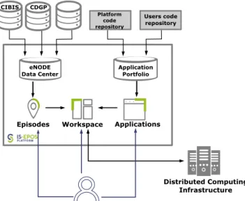
The TCS AH research infrastructure is integrated and provided to the community through the IS-EPOS Platform. The platform (Fig. 2) provides access to:• data and metadata gathered in the form of episodes with associated tools for data and metadata search and visualization;
• applications for online data processing;
• user-organized workspaces for storing and sharing data and applications.
In addition to the direct access via the IS-EPOS Platform, TCS AH will also be integrated with the EPOS-ERIC IT infrastructure. This will enable all EPOS users to access the data and functionality of the IS-EPOS Platform and to use them in multidisciplinary projects conducted with tools provided by the wider EPOS-ERIC IT Platform.
Data records and acquisition. Episode datasets related to investigations of particular anthropogenic
haz-ard phenomena are maintained by participating institutions forming separate eNodes (e.g. CIBIS and CDGP eNodes). Data in eNodes are formatted in accordance with IS-EPOS Platform data-format specifications and described with associated metadata. The data are provided in unified formats, described in the IS-EPOS Platform
www.nature.com/scientificdata
www.nature.com/scientificdata/
documentation (docs.cyfronet.pl/display/ISDOC/Data + formats). The data formats are based, as far as possible, on existing standard formats (e.g. seed, mseed, QuakeML, InventoryXML), but for the types of data for which there are no established standard formats, the platform uses custom Matlab-based formats: catalog, GDF (Generic
Data Format) and MDDF (Multi-Dimensional Data Format). The GDF and MDDF files have been designed as
smart structures to store diverse scientific data, for example, water quality, air quality, industrial production data and geological/geophysical data. These data formats are very widely used and easy to use for further processing. GDF and MMDF files contain the identity of the geographic coordinate system in which data are stored, the time zone in which the time is determined, and information about the stored data, such as units, data type, and names of variables with descriptions. These metadata are stored in the CRF field (Coordinate Reference System) of the Matlab structure. Geographical data are usually stored using the WGS-84 ellipsoid reference coordinate system. Coordinate conversion to WGS-84 is a part of the IS-EPSOS Platform data integration process before the data undergoes thorough quality control and made available to users. There are also a number of format converter applications on the IS-EPOS Platform, which allow conversion from the internal formats to user-selected formats when the data is downloaded.
The associated metadata make the data discoverable and searchable, provide additional information about the content and origin of a specific data item and provide information on any access policy. Both data and metadata are subject to quality control (see: Technical Validation section below). Every episode published on the IS-EPOS Platform has a unique DOI for citation and direct access to the original data source, which is crucial under FAIR data principles. All the metadata coming from different eNodes are collected and indexed in the eNode Data Center.
Applications. Applications allow the processing of data from the IS-EPOS Platform as well as that uploaded by
the user. Applications range from simple data management routines to advanced services for specialized data analysis. The latter are software packages developed, maintained and published by researchers. Future develop-ment of the IS-EPOS Platform should enable users to run their own data-analysis scripts within the platform (Fig. 3).
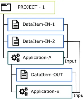
Workspace. The workspace provides the user with a framework to organize data and applications into integrated
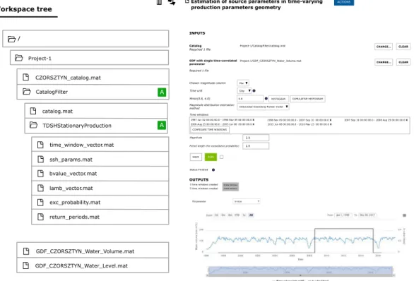
scientific projects. Data in workspaces are represented as files and they can be organized within a hierarchy of directories (Fig. 4). Each data file has its own metadata information allowing the user to match compatible appli-cations with it. Users can add appliappli-cations to their personal workspace in order to execute them on selected data and capture the resulting output. An application in a workspace is represented by a special kind of directory. This directory both organizes the data and provides an interface to handle data processing parameters, trigger the computation, as well as visualize, preserve and export the processed output (see Fig. 5). The processing itself is delegated to a distributed computing infrastructure (cloud or high-performance computers). The output of an application execution is stored in the application directory and may become input for another application. Consequently, a series of applications with their resultant data may be combined to form a workflow.
All data stored in the user’s workspace can be shared with other users of the platform, either in an editable or read-only mode. Similarly, the application settings and processing workflows can be shared.
Fig. 2 General architecture of IS-EPOS Platform with its main components: Episodes (data and metadata), Workspace and Applications. Episode data are stored in eNodes, fed into the eNode Data Center and then offered to the user. On their request, the data is loaded to a user’s Workspace. Application codes are stored in the code repositories, gathered in an Application Portfolio, and then shown to the user. These can then be loaded into a Workspace and executed on Distributed Computing Infrastructure.
Integration with EPOS-ERIC IT. Ultimately, all ten thematic core services of EPOS, including TCS AH, will be
integrated into the EPOS-ERIC IT infrastructure known as Integrated Core Services, ICS, where users will be able to discover, access and process multidisciplinary datasets available from the individual TCSs. TCS AH is inte-grated with the EPOS Authentication, Authorization and Accounting Infrastructure (EPOS AAAI). This allows TCS AH users to log on to the ICS platform with their existing credentials and wider EPOS users to access TCS AH data and applications. There is also an authorization mechanism to recognize various user roles and attributes through the EPOS AAAI in order to grant access to specific resources within the platform. This is implemented using standard protocols such as OpenId Connect and OAuth 2.0. The interactions involved in these protocols are depicted in Fig. 6.
Another aspect of integration with the ICS is related to the metadata that describes data maintained by the individual TCSs. These metadata are harvested and converted by the ICS to make the data discoverable and usable in a uniform way across the different EPOS TCS platforms.
Fig. 3 IS-EPOS Platform applications, combined from the official code repository, as well as from a custom user code repository. The applications have references to associated publications stored in the document repository.
www.nature.com/scientificdata
www.nature.com/scientificdata/
User engagement and science-industry partnership.
The AH community is comprised of stakehold-ers from academia, industry, educational institutions, NGOs, the public and government organizations. Spreading awareness of AH phenomena and the services offered by TCS AH has involved building an online presence (project website content, social media communications, online newsletters), face-to-face interaction (outreach events, scientific workshops, IS-EPOS Platform training workshops) and scientific dissemination (peer reviewed publications, conference presentations and participation at events in, and related to, the field of anthropogenic hazards). Approximately 10 training workshops have taken place with over 200 AH community stakeholders from the scientific community being trained to use the IS-EPOS Platform across 7 countries during the course of the EPOS-IP project. In addition to gaining feedback on the IS-EPOS Platform, the training events organized by TCS AH and important face-to-face stakeholder engagements have fostered the development of new ideas for the use of the integrated research infrastructure. The IS-EPOS Platform has also been used as a teaching tool inFig. 5 Sample application localized in a workspace, displaying the form of parameters, computation status and resulting visualization. The resulting data are stored in the application directory within a workspace tree, on the left.
Fig. 6 The process of user authentication to the IS-EPOS portal using an EPOS AAAI account. Numbers refer to the flow of actions.
an educational project aimed at junior high and high schools called ERIS – Exploitation of Research Results in School practice, funded with support from the European Commission within the ERASMUS + Programme. It has also been integrated into university teaching as an educational and effective research resource at several of the TCS AH consortium institutions.
By August 2019, the IS-EPOS Platform had more than 1000 registered users (an increase of 720% since the launch of the EPOS-IP project in 2015). To stimulate further the use of the platform and the provision of services, the TCS AH consortium is open to new collaborations. Data and/or software from new potential partners, from on-going or past projects are welcome. Collaboration is also sought with companies producing equipment for seismic activity monitoring or accompanying processes. The ambition is not only to be a provider of an e-research environment but also to perform intercommunity social functions like project brokering and developing oppor-tunities for new interdisciplinary and international collaborations.
Governance and future perspectives.
The TCS AH community is organized around a TCS AH con-sortium of 13 partnering institutions (suppliers of data and/or services) from 8 European countries. The work of the consortium is governed by a Consortium Board consisting of representatives of all the partners and with a director elected for 5 years by a majority of the board. Five sections have been established within TCS AH: (a) Implementation of services; (b) Administration, law & accounting; (c) Episodes integration and application implementation; (d) Promotion and dissemination; (e) Projects & partnership. There are two external commit-tees, the Data Provider and User committees which are composed of the main representatives of the respective communities, selected by the majority of the board to advise the director. An Innovation Advisory Committee consisting of stakeholders from academia, industry, local and central administration bodies, society and others, invited by the Consortium Board, consults on the decision-making processes behind TCS AH developments. Membership of the TCS AH consortium is open to new partners.The plan is to establish TCS AH as a coherent coordinating framework for the AH community, together with a robust research infrastructure to develop strategic research capacity for addressing AH challenges. The goals are to facilitate new discoveries, connect the stakeholder community, boost public understanding of AH, develop outreach materials for the public and future scientists, stimulate innovation through knowledge transfer, provide solutions to industrial partners and engage in a three-way transfer of knowledge between industry, science and society.
Resource Description
Data records and acquisition – cross-national episode eNodes.
IG PAS eNode – CIBIS. The IGPAS eNode ‘Induced Seismicity Research Infrastructure Center’ (CIBIS) is located in Krakow, Poland and man-aged by the Institute of Geophysics Polish Academy of Sciences, where more than 30 AH episodes from various projects are stored and maintained (Figs. 2 and 7), covering a broad variety of industrial activities. The majority of the episodes relate to induced seismicity and ground instability from underground mining (10 episodes). Water reservoir impoundment is the second most represented industrial activity (6 episodes). Next are conventional hydrocarbon extraction, underground fluid storage and geothermal energy production episodes (5 data sets,
www.nature.com/scientificdata
www.nature.com/scientificdata/
including one complex episode involving CO2 storage). Episodes on unconventional hydrocarbon extraction
related to fracking (4 data sets) are also stored in CIBIS with data included from the H2020 projects SHEER (Shale gas Exploration and Exploitation Induced Risks) and S4CE (Science 4 Clean Energy). The integrated episodes are located mainly in Europe (24), but also in Northern America (3) and Asia (3) (Fig. 7).
Data within the episodes mostly include geophysical observations related to the anthropogenic hazard acquired directly from instrumental measurements as well as industrial data describing the processes potentially causing the hazard. Geophysical data include seismological event catalogs, ground motion catalogs and waveform data, but also water and air quality data from in situ and laboratory measurements. Geological data, including bedrock geology and tectonic features are also included, as well as geospatial and geotemporal data related to the causal activity. Every episode also contains a brief description of the locality and potentially hazard-inducing pro-cesses together with references and complementary documentation. A typical episode summary page is shown in Fig. 8.
CDGP eNode. The ‘Data Centre for Deep Geothermal Energy’ (Centre de Données de Géothermie Profonde
- CDGP) archives data collected at the Upper Rhine Graben geothermal sites and distributes them to the scientific community, taking relevant intellectual property rights into account. It is located at the École et Observatoire des Sciences de la Terre (EOST, Université de Strasbourg, CNRS), and was created by the LabEx G-eau-thermie Profonde, a research program on deep geothermal energy founded by the French Ministry of Research and Education under the “Laboratories of Excellence” initiative. It operates as a standalone data cen-tre (cdgp.u-strasbg.fr) but has also been incorporated as an eNode of TCS AH, available through the IS-EPOS Platform.
Data distributed by the CDGP consist of seismological (catalogs, waveforms) and hydraulic data that were acquired during stimulation or circulation phases at the Soultz-sous-Forêts pilot plant during the research period (1988–2010). Other geophysical data (gravimetric, magnetic, InSAR, geodesy, velocity model, etc.) will be also added to the data store in the future, as well as other data from different projects (Rittershoffen, Illkirch, Vendenheim). Agreements with industrial partners allow the CDGP to distribute particular data to the academic
community. The CDGP infrastructure directly shares as much information as possible such as episode metadata with the IS-EPOS Platform to avoid work duplication, however, some special tasks are necessary to complete the metadata information needed by the IS-EPOS Platform as well as the reformatting of certain data.
applications.
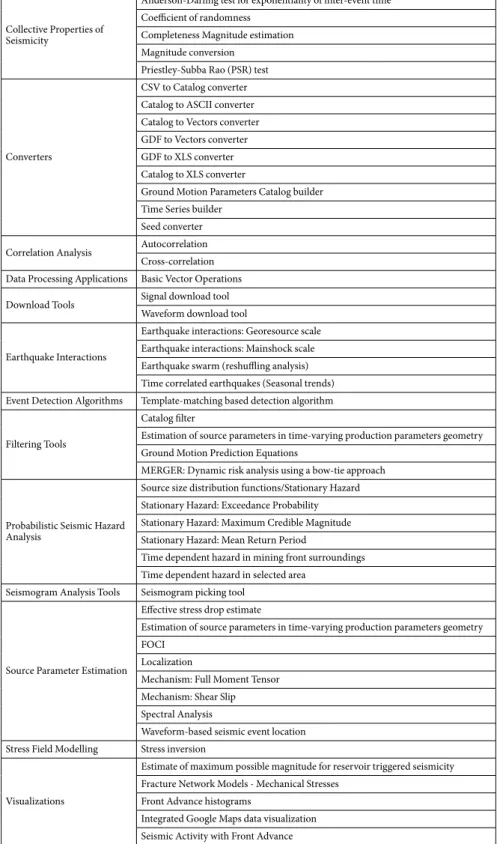
The IS-EPOS Platform provides users with a range of data analysis and manipulation routines. These are mostly (but not exclusively) Matlab or Python programs that allow analysis, processing and visualis-ation of data available on the platform or imported into it16,17. Currently, 44 applications are integrated into theCollective Properties of Seismicity
Anderson-Darling test for exponentiality of inter-event time Coefficient of randomness
Completeness Magnitude estimation Magnitude conversion
Priestley-Subba Rao (PSR) test
Converters
CSV to Catalog converter Catalog to ASCII converter Catalog to Vectors converter GDF to Vectors converter GDF to XLS converter Catalog to XLS converter
Ground Motion Parameters Catalog builder Time Series builder
Seed converter Correlation Analysis Autocorrelation
Cross-correlation Data Processing Applications Basic Vector Operations Download Tools Signal download tool
Waveform download tool Earthquake Interactions
Earthquake interactions: Georesource scale Earthquake interactions: Mainshock scale Earthquake swarm (reshuffling analysis) Time correlated earthquakes (Seasonal trends) Event Detection Algorithms Template-matching based detection algorithm Filtering Tools
Catalog filter
Estimation of source parameters in time-varying production parameters geometry Ground Motion Prediction Equations
MERGER: Dynamic risk analysis using a bow-tie approach
Probabilistic Seismic Hazard Analysis
Source size distribution functions/Stationary Hazard Stationary Hazard: Exceedance Probability Stationary Hazard: Maximum Credible Magnitude Stationary Hazard: Mean Return Period
Time dependent hazard in mining front surroundings Time dependent hazard in selected area
Seismogram Analysis Tools Seismogram picking tool
Source Parameter Estimation
Effective stress drop estimate
Estimation of source parameters in time-varying production parameters geometry FOCI
Localization
Mechanism: Full Moment Tensor Mechanism: Shear Slip Spectral Analysis
Waveform-based seismic event location Stress Field Modelling Stress inversion
Visualizations
Estimate of maximum possible magnitude for reservoir triggered seismicity Fracture Network Models - Mechanical Stresses
Front Advance histograms
Integrated Google Maps data visualization Seismic Activity with Front Advance
www.nature.com/scientificdata
www.nature.com/scientificdata/
IS-EPOS Platform grouped into 13 thematic categories (Table 1) in order to facilitate particular research analyses related to anthropogenic hazards. Some programs can be freely downloaded under the terms of a GNU General Public License.
The integrated applications comprise software tools which implement peer-reviewed techniques designed for dealing with specific scientific issues. These tools enable the user to perform research operations and analyses based on either seismic catalog data (e.g. correlation analysis, probabilistic seismic hazard assessment, earthquake interactions, stress field modelling and collective properties of seismicity) or waveform recordings (e.g. seismic event detection algorithms, event location, source parameter estimation including moment tensor inversion, and spectral analysis). In order to achieve more flexible workflows and a user-friendly environment, these applications are supported by a variety of data handling and visualization applications for performing basic parameter opera-tions and data filtering, converting catalog and waveform data formats and graphically visualizing seismic as well as operational data. The results of the applications can be downloaded, reformatted, visualized, and used as input for further analysis. The user can create individual projects within their personal workspace, which can then be shared with other colleagues or research teams.
New applications are being developed and added in the Continuous Integration and Continuous Delivery (CI/ CD) scheme bringing additional scientific potential to the platform, improving the user experience and increas-ing the ability to conduct advanced studies in the field of anthropogenic hazards. Advanced applications (template matching and multi-scale array-based algorithms for microseismicity detection and location, statistical toolboxes for magnitude complexity analysis and seismic event clustering) are being developed and are ultimately planned to be integrated into the IS-EPOS Platform as part of the project SERA —H2020-INFRAIA-2016-1.
In order to make the IS-EPOS Platform more inclusive and user friendly, future development plans for the platform include the introduction of the choice of user language. The ultimate goal is to provide the users with the ability to upload their own code scripts and to modify the source code of existing applications according to their specific requirements.
Document repository.
The IS-EPOS Platform provides a repository of documents associated with epi-sodes and applications. This e-repository is powered by EPrints 3 (GLU license, www.eprints.org) which has been developed by the School of Electronics and Computer Science at the University of Southampton, UK. Thus the IS-EPOS Platform documents support OAI 2.0 with a base URL of tcs.ah-epos.eu/eprints/cgi/oai2. The front page is organized so that legal requirements, the user guide, guidance on how to cite the IS-EPOS Platform and other references to episodes and applications, can be directly accessed. The platform legal regulations contain documents regarding data policy, the data management plan and TCS AH governance services.The user guide section consists of technical documents with instructions to assist using the IS-EPOS Platform, with a step-by-step tutorial on how to access and make use of particular applications. Links to the user guide for specific applications are also available from the application level. The user guide also includes guidance about data formats and the vocabulary of the IS-EPOS Platform.
The IS-EPOS Platform documents are thematically organized and classified, consisting of links to relevant articles, books, book sections, conference and workshop items or reports. There are currently 858 items in the e-repository. The internal search engine allows browsing using filters and search criteria. Items are classified according to episode, type of hazard-inducing phenomenon, monitoring technology, and geographic region. Consequently, the elements of the document repository can be readily accessed by applying specific filters. In addition, references relating to particular episodes and applications are also available as a link from their
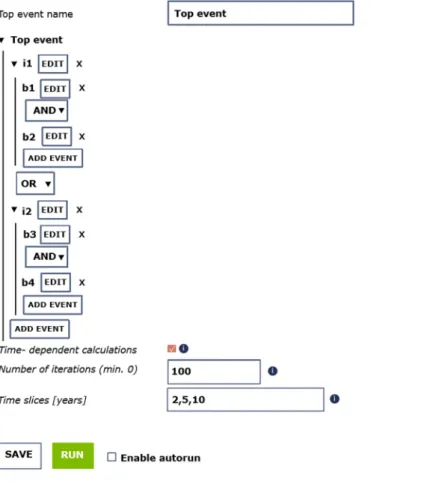
Fig. 10 View of the graphical user interface available for the input of a fault tree (data and logic structure) in MERGER.
Fig. 11 Example of the output produced by MERGER and shown on the IS-EPOS Platform for the top event of a fault tree. The selected output is displayed directly in the workspace, other results can be selected in the workspace tree on the left.
www.nature.com/scientificdata
www.nature.com/scientificdata/
respective sections on the platform. There is also a collection of links to documents that reference the IS-EPOS Platform itself. (tcs.ah-epos.eu/eprints/id/saved_search/5).
Integration of new episodes data – quality control procedure.
Quality control of the integrated and published episode data is carried out according to the diagram shown in Fig. 9 which illustrates the data processing steps and relevant control points. An open-source project web system is used to manage the episode integration process (Redmine, www.redmine.org). This allows the assignment and management of personnel responsible for the episode integration, as well as tracking the progress of that integration. The uploaded data are prepared, checked and validated to ensure that they conform to commonly used standards and formats. Any inconsistencies in the data structure are identified by the quality control team. Once the data and metadata are approved, they are made available on the IS-EPOS Platform test portal from the external source. The episodeFig. 12 Workflow of analysis of correlation between injection rate and seismic activity rate during geothermal energy production.
quality and integrity is then reviewed together with the data owner before the data and associated metadata is made public on the IS-EPOS Platform.
application Validation
Any code intended to be integrated as an IS-EPOS Platform application has to pass a two-step validation before it is released in the application portfolio. First, before the integration process starts, a technical validation aims to determine whether the code meets the technical requirements of integration. The program is checked to ascertain if it can be run on distributed computing infrastructure, if the licences (of the code itself or the libraries it uses)
Fig. 13 Example of the integrated visualization of water reservoir triggered seismicity and the triggering technological operations.
www.nature.com/scientificdata
www.nature.com/scientificdata/
allow for its use on the IS-EPOS Platform and if the input and output file formats are compatible with the plat-form. The second step of validation includes thorough testing of the integrated application before releasing it to the public. This is an evaluation of the interface and the application potential by testing the application with var-ious data samples available on the platform, an assessment of the application potential to build chains with other integrated applications to form a workflow, an evaluation of the usefulness of the application documentation, and the identification of bugs. This stage of validation may be an iterative process, including improvements to the code and reassessment of its functionality.
Fig. 14 Illustration of the workflow for seismic hazard analysis. Left - the workflow, right – platform screen snapshots.
Usage Examples
Example of application available on IS-EPOS platform.
Complementary to the data-handling, pro-cessing and visualization tools, the IS-EPOS Platform also provides a set of tools for tackling complex multi-haz-ard risk (MHR) scenarios usually found in activities related to the development of georesources. A service called “Simulator for Multi-hazard risk assessment in ExploRation/exploitation of GEoResources” (MERGER) has been designed to provide tools for probabilistic multi-hazard analyses18.The main objective of this tool is to provide a quantitative model for performing highly specialized MHR assessments in which risk pathway scenarios are structured using a bow-tie approach, which implements the integrated analysis of fault trees and event trees. The methodology implemented in this service is suitable for performing dynamic environmental risk assessments. This is characterized by the bow-tie structure coupled with a wide range of probabilistic models flexible enough to consider different typologies of phenomena, the Bayesian implementation for data assimilation, the handling and propagation of modelling uncertainties and the possibil-ity of integrating data derived from integrated assessment modelling.
Once MHR scenarios have been identified and structured according to a bow-tie logic, both the scenario structure and the data can be loaded through a user-friendly graphical interface which guides the user through this process (Fig. 10).
The output produced by this tool provides probabilistic assessments of the fault trees and event trees that were implemented for analyzing a given MHR scenario. Data output is provided numerically (in a log file) and graph-ically (e.g., through histograms) for each event of interest (as for example shown in Fig. 11).
Use case 1: Studying correlation between injection rate and seismicity rate.
Discovering the nature of the relationships between induced seismicity and the industrial factors that are its cause is probably the most important goal of anthropogenic seismicity studies because only the understanding of such relationships can lead to the development of methods to mitigate the anthropogenic seismic hazard. The example in Fig. 12presents the steps in investigating if and how the seismicity induced by geothermal energy production correlates with the rate of fluid injection. The data for this use case has been taken from the episode “The Geysers Prati 9 and Prati 29 cluster”19 on the IS-EPOS Platform (tcs.ah-epos.eu/#episode:THE_GEYSERS_Prati_9_and_Prati_29_
cluster, doi:10.25171/InstGeoph_PAS_ISEPOS-2017-011) and the analysis makes use of applications integrated on the platform.
Use case 2: Integrated visualization of artificial lake water level changes and triggered seismicity.
Comprehensive visualization tools available on the IS-EPOS Platform enable integrated visual inspection of multidisciplinary data. The example presented in Fig. 13 is taken from the episode “Czorsztyn” of seismicity triggered by the impoundment of an artificial lake https://tcs.ah-epos.eu/#episode:CZORSZTYN, doi:10.25171/ InstGeoph_PAS_ISEPOS-2017-004. It shows the steps leading to the visualization of the triggered earthquake locations and magnitudes, the location of seismic recording stations, the lake shoreline on a topographic map background, and the occurrence times and sizes of the earthquakes superimposed on the lake water level time series. The IS-EPOS Platform maps data in WGS-84 ellipsoid coordinates, so datasets from various regions of the globe can be directly compared. Detailed information about the coordinate system used for a particular dataset is included in a file structure description and in the metadata.
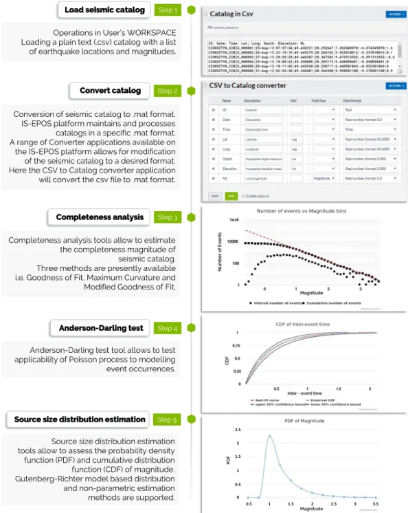
Use case 3: Seismic hazard assessment.
The IS-EPOS Platform features enable complex scientific anal-yses. The workflow diagram in Fig. 14 shows steps of an example analysis towards seismic hazard assessment. The presented analysis starts with loading a seismic catalog in csv format into the user’s workspace. After converting the catalog into the internal IS-EPOS (.mat) format, the user carries out the analysis using various applications available on the platform. The user can execute advanced statistical applications that support both parametric and nonparametric methods, and perform analyses leading to the probabilistic seismic hazard assessment in a stationary or time-dependent mode. Applications implemented on the platform also allow performing a range of alternative analyses based on adopted scenarios. The user can conduct ground motion prediction, source param-eters estimation, etc.Data availability
The datasets of episodes are available on the IS-EPOS Platform of Thematic Core Service Anthropogenic Hazards: tcs.ah-epos.eu. In accordance with the EPOS Data Policy which is available at www.epos-ip.org; and in accordance with TCS AH Data Policy, which is available at www.tcs.ah-epos.eu; datasets and applications are licensed under the Creative Commons Attribution 4.0 International License, CC:BY.
Code availability
Applications are available on the IS-EPOS Platform of Thematic Core Service Anthropogenic Hazards: tcs.ah-epos.eu. The source code of the platform itself is available at bit.ly/ISEPOSsourcecode.
Received: 17 October 2019; Accepted: 27 February 2020; Published online: 11 March 2020
References
1. Lasocki, S. & Orlecka-Sikora, B. Anthropogenic Seismicity Related to Exploitation of Georesources. Encyclopedia of Solid Earth Geophysics. Encyclopedia of Earth Sciences Series (ed. Gupta, H.) (Springer, Cham., 2020).
2. Gupta, H. K. A review of recent studies of triggered earthquakes by artificial water reservoirs with special emphasis on earthquakes in Koyna, India. Earth-Science Reviews 58, 279–310 (2002).
www.nature.com/scientificdata
www.nature.com/scientificdata/
3. Etiope, G. & Martinelli, G. Migration of carrier and trace gases in the geosphere: an overview. Physics of the Earth and Planetary Interiors 129, 185–204 (2002).
4. Osborn, S., Vengosh, A., Warner, N. & Jackson, R. Methane contamination of drinking water accompanying gas-well drilling and hydraulic fracturing. Proceedings of the National Academy of Sciences 108, 8172–8176 (2011).
5. Davies, R., Foulger, G., Bindley, A. & Styles, P. Induced seismicity and hydraulic fracturing for the recovery of hydrocarbons. Marine and Petroleum Geology 45, 171–185 (2013).
6. Rivard, C. et al. An overview of Canadian shale gas production and environmental concerns. International Journal of Coal Geology
126, 64–76 (2014).
7. Vengosh, A., Jackson, R., Warner, N., Darrah, T. & Kondash, A. A critical review of the risks to water resources from unconventional shale gas development and hydraulic fracturing in the United States. Environmental Science & Technology 48, 8334–8348 (2014). 8. Grigoli, F. et al. Current challenges in monitoring, discrimination, and management of induced seismicity related to underground
industrial activities: a European perspective. Rev. Geophys. 55, 310–340 (2017).
9. Foulger, G., Wilson, M., Gluyas, J., Julian, B. & Davies, R. Global review of human-induced earthquakes. Earth-Science Reviews 178, 438–514 (2018).
10. Orlecka-Sikora, B., Cielesta, S. & Lasocki, S. Tracking the development of seismic fracture network from The Geysers geothermal field. Acta Geophysica 67, 341–350 (2018).
11. Lee, K. et al. Managing injection-induced seismic risks. Science 364, 730–732 (2019).
12. Lasocki, S., Orlecka-Sikora, B., Mutke, G., Pytel, W. & Rudziński, Ł. A catastrophic event in Rudna copper-ore mine in Poland on 29 November, 2016: what, how and why. In: Proc. 9th Int. Symp. on Rockbursts and Seismicity in Mines – RaSiM9, November 15–17, Santiago, Chile (Vallejos, J. A. ed.), Editec S. A., Santiago, Chile, 316–324 (2017).
13. Deichmann, N. & Giardini, D. Earthquakes induced by the stimulation of an enhanced geothermal system below Basel (Switzerland). Seismological Research Letters 80, 784–798 (2009).
14. Sintubin, M. The Groningen case: when science becomes part of the problem, not the solution. Seismological Research Letters 89, 2001–2007 (2018).
15. Wilkinson, M. D. et al. The FAIR Guiding Principles for scientific data management and stewardship. Sci. Data 3 (2016). 16. Rudziński, Ł. et al. IS-EPOS Platform for Anthropogenic Seismicity Research: a modern e-tool of EPOS Thematic Core Service
“Anthropogenic Hazards”, designed to integrate infrastructures and facilitate research of human induced seismicity. In: Proc. 9th Int. Symp. on Rockbursts and Seismicity in Mines – RaSiM9, November 15–17, Santiago, Chile (Vallejos, J. A. ed.), Editec S. A., Santiago, Chile, 15–22 (2017).
17. Leptokaropoulos, K. M. et al. IS-EPOS: a platform for anthropogenic seismicity research. Acta Geophysica 67, 299–310 (2019). 18. Garcia-Aristizabal, A., Kocot, J., Russo, R. & Gasparini, P. A probabilistic tool for multi-hazard risk analysis using a bow-tie
approach: application to environmental risk assessments for geo-resource development projects. Acta Geophysica 67, 385–410 (2019).
19. Kwiatek, G. et al. Effects of long-term fluid injection on induced seismicity parameters and maximum magnitude in northwestern part of The Geysers geothermal field. Journal of Geophysical Research: Solid Earth 120, 7085–7101 (2015).
Acknowledgements
This work was supported by the EPOS Implementation Phase (EPOS IP) project funded by the EU Horizon 2020 programme under Grant Agreement Number 676564 and by the Seismology and Earthquake Engineering Research Infrastructure Alliance for Europe (SERA) project funded by the EU Horizon 2020 programme under Grant Agreement Number 730900. This work was supported in part by national research funds in the scope of the co-financed international projects framework (Agreements no.: 3504/H2020/15/2016/2 and 3503/ H2020/15/2016/2). This work was partially financed as a part of the statutory activity from the subvention of the Ministry of Science and Higher Education of Poland.
author contributions
Beata Orlecka-Sikora: Coordination of TCS AH implementation within EPOS-PP and EPOS-IP projects, developing the main ideas of TCS AH and IS-EPOS Platform functionalities, preparing the concept of the manuscript, contributing to the manuscript writing, revising of the manuscript. Stanisław Lasocki: Developing the main ideas of TCS AH and IS-EPOS Platform functionalities, software writing, contributing to the manuscript writing, revising of the manuscript. Joanna Kocot: Developing the IT solutions for IS-EPOS Platform functionalities, implementing the functionalities of the platform, integrating the eNodes and applications into the platform, integrating the IS-EPOS Platform with the ICS of EPOS, contributing to the manuscript writing. Tomasz Szepieniec: Developing the IT solutions for IS-EPOS Platform functionalities, implementing the functionalities of the platform, integrating the eNodes and applications into the platform, integrating the IS-EPOS Platform with the ICS of IS-EPOS, contributing to the manuscript writing. Jean Robert Grasso: Contributing to the TCS AH and IS-EPOS Platform design, software writing, episode integration, contributing to the manuscript writing. Alexander Garcia: Contributing to the TCS AH and IS-EPOS Platform design, software writing, episode integration, contributing to the manuscript writing. Marc Schaming: Contributing to the TCS AH and IS-EPOS Platform design, software writing, coordinating the episode integration process in eNode, contributing to the manuscript writing. Paweł Urban: Visualization development, coordinating and contributing to the episode integration process. Glenda Jones: Contributing to the TCS AH and IS-EPOS Platform outreach and user engagement, contributing to the manuscript writing. Ian Stimpson: Contributing to the TCS AH and IS-EPOS Platform outreach and user engagement, testing IS-EPOS solutions, contributing to the manuscript writing, revising of the manuscript. Savka Dineva: Contributing to the development of the legal framework of TCS AH, contributing to the TCS AH and IS-EPOS Platform outreach and user engagement. Piotr Sałek: Contributing to the TCS AH and IS-EPOS Platform development, software writing, episode integrating, testing IS-EPOS solutions, revising of the manuscript. Konstantinos Leptokaropoulos: Contributing to the IS-EPOS Platform development, software writing, contributing to the manuscript writing. Grzegorz Lizurek: Contributing to the TCS AH and IS-EPOS Platform outreach and user engagement, visualization development, contributing to the manuscript writing. Dorota Olszewska: Contributing to the TCS AH and IS-EPOS Platform development, software writing, implementing the document repository, contributing to the manuscript writing. Jean Schmittbuhl: Contributing to the software writing, contributing to the manuscript writing. Grzegorz Kwiatek: Contributing to the TCS AH and IS-EPOS Platform development, software writing, contributing to
the manuscript writing. Aglaja Blanke: Episode integrating, contributing to the manuscript writing. Gilberto Saccorotti: Contributing to the software writing and episode integration. Karolina Chodzińska: Contributing to the TCS AH and IS-EPOS Platform outreach and user engagement. Łukasz Rudziński: Contributing to the TCS AH and IS-EPOS Platform design, contributing to the software writing. Izabela Dobrzycka: Contributing to the TCS AH and IS-EPOS Platform design, contributing to the episode integration. Grzegorz Mutke: Contributing to the episode integration. Adam Barański: Contributing to the episode integration. Aleksandra Pierzyna: Contributing to the episode integration. Elena Kozlovskaya: Contributing to the TCS AH and IS-EPOS Platform user engagement, contributing to the episode integration. Jouni Nevalainen: Contributing to the TCS AH and IS-EPOS Platform user engagement, contributing to the episode integration. Jannes Kinscher: Contributing to the episode integration. Jan Sileny: Contributing to the software writing. Mariusz Sterzel: Developing the IT solutions for IS-EPOS Platform, implementing the functionality of the platform. Szymon Cielesta: Contributing to the TCS AH and IS-EPOS Platform design, contributing to manuscript writing. Tomas Fischer: Contributing to the software writing.
Competing interests
The authors declare no competing interests.
additional information
Correspondence and requests for materials should be addressed to B.O.-S. Reprints and permissions information is available at www.nature.com/reprints.
Publisher’s note Springer Nature remains neutral with regard to jurisdictional claims in published maps and
institutional affiliations.
Open Access This article is licensed under a Creative Commons Attribution 4.0 International
License, which permits use, sharing, adaptation, distribution and reproduction in any medium or format, as long as you give appropriate credit to the original author(s) and the source, provide a link to the Cre-ative Commons license, and indicate if changes were made. The images or other third party material in this article are included in the article’s Creative Commons license, unless indicated otherwise in a credit line to the material. If material is not included in the article’s Creative Commons license and your intended use is not per-mitted by statutory regulation or exceeds the perper-mitted use, you will need to obtain permission directly from the copyright holder. To view a copy of this license, visit http://creativecommons.org/licenses/by/4.0/.