AbstrAct
this report of the swiss seismological service summarizes the seismic activity in switzerland and surrounding regions during 2007. During this period, 531 earthquakes and 92 quarry blasts were detected and located in the region un-der consiun-deration. Of these earthquakes, 30 are aftershocks of the stimulation of a proposed geothermal reservoir beneath the city of basel in December of 2006. With 20 events with ML ≥ 2.5, four of which were artificially induced, the
seismic activity in the year 2007 was far below the average over the previous 32 years.
ZusAmmenfAssung
Dieser bericht des schweizerischen erdbebendienstes stellt eine Zusammen-fassung der im Vorjahr in der schweiz und umgebung aufgetretenen erdbe-ben dar. Im Jahr 2007 wurden im erwähnten gebiet 531 erdbeerdbe-ben sowie 92 sprengungen erfasst und lokalisiert. Dreissig dieser erdbeben sind
nachbe-ben der im Dezember 2006 erfolgten Wasserinjektion in 5 km tiefe bei einem geothermie Projekt in basel. mit 20 beben der magnitude ML ≥ 2.5, wovon 4
im Zusammenhang mit dem geothermie Projekt stehen, war die seismische Aktivität im Jahr 2007 weit unter dem Durchschnitt der vorhergehenden 32 Jahre.
resume
Le présent rapport du service sismologique suisse résume l’activité sismique en suisse et dans les régions limitrophes au cours de l’année 2007. Durant cette période, 531 tremblements de terre et 92 tirs de carrière ont été détectés et localisés dans la région considérée. Parmi ces tremblements de terre, 30 ont été induits artificiellement par la stimulation d’un réservoir au dessous de la ville de bâle dans le cadre d’un projet géothermique. Avec seulement 20 événements de magnitude ML ≥ 2.5, et dont 4 ont été induits
artificielle-ment, l’activité sismique de l’année 2007 est inférieure à la moyenne de ces 32 années précédentes.
Introduction
Past earthquake activity in and around switzerland has been documented in an uninterrupted series of annual reports from 1879 until 1963 (Jahresberichte des Schweizerischen
Erdbeben-dienstes). three additional annual reports have been published for the years 1972–1974. these reports together with historical records of earthquakes dating back to the 13th century have been summarized by Pavoni (1977) and provided the basis for the first seismic hazard map of switzerland (sägesser & mayer-rosa 1978). With the advent of routine data processing by computer, the wealth of data acquired by the nationwide seismograph network has been regularly documented in bulle-tins with detailed lists of all recorded events (Monthly Bulletin
of the Swiss Seismological Service). since 1996, annual reports summarizing the seismic activity in switzerland and
surround-ing regions have been published in the present form (baer et al. 1997, 1999, 2001, 2003, 2005, 2007; Deichmann et al. 1998, 2000a, 2002, 2004, 2006). In the course of reassessing the seismic haz-ard in switzerland, a new uniform earthquake catalog covering both the historical and instrumental periods has been compiled (fäh et al. 2003). the data in the new earthquake catalog of switzerland (ecOs) are available online (http://www.seismo. ethz.ch, swiss earthquake catalogs). the new seismic hazard map of switzerland based on this catalog was officially released in 2004 (giardini et al. 2004). In addition, numerous studies cov-ering different aspects of the recent seismicity of switzerland have been published in the scientific literature (for an overview and additional references see, e.g. Deichmann 1990; Pavoni & roth 1990; rüttener 1995; rüttener at al. 1996; Pavoni et al. 1997; Deichmann et al. 2000b; Kastrup et al. 2004; Kastrup et al. 2007).
earthquakes in switzerland and surrounding regions during 2007
N
icolasD
eichmaNN, m
aNfreDB
aer, J
ohNc
liNtoN, s
tephaNh
useN, D
oNatf
äh, D
omeNicoG
iarDiNi,
p
hilippK
ästli, u
rsK
raDolfer& s
tefaNW
iemerKey words: earthquakes, focal mechanisms, moment tensors, switzerland
1661-8726/08/030659-9
DOI 10.1007/s00015-008-1304-y birkhäuser Verlag, basel, 2008
swiss J. geosci. 101 (2008) 659–667
Data acquisition and analysis
Seismic stations in operation during 2007
the swiss seismological service operates two separate na-tionwide seismic networks, a high-gain broad-band seismo-meter network and a low-gain accelerograph network. the former is designed to monitor continuously the ongoing earthquake activity down to magnitudes well below the hu-man perception threshold, whereas the latter is principally aimed at engineering concerns and thus only records so-called strong motions. beginning in 2003, efforts are underway to merge these two networks and to record the strong-motion signals continuously and in real-time together with the high-gain signals. first, 12 stations of the high-high-gain broad-band network have been equipped with an additional accelero-meter. then as of 2006, 10 sites of the existing accelerometer network as well as several new sites have been equipped with modern sensors and digitizers featuring higher dynamic range, broader frequency bandwidth and higher sensitivity (baer et al. 2007).
to monitor with greater precision an ongoing sequence of earthquakes in the immediate vicinity of the southern segment of the new gotthard railway tunnel that is still under construc-tion, a set of eight stations with short-period seismometers and in part with three-component accelerometers were installed during the late fall of 2005 in the region between the Lukmanier Pass and the Leventina Valley. In addition, two accelerometers have been installed in the tunnel itself. these ten stations are operated under a contract with Alptransit-gotthard Ag.
In the course of 2006 an additional array of seismic sensors was installed in six boreholes at depths between 317 and 2740 m below basel. this array was designed to monitor the seismicity induced by the injection of large quantities of water at high pressure into a 5 km deep well in the context of a project initi-ated by geopower basel Ag, a private/public consortium, to extract geothermal energy. the borehole array is operated by geothermal explorers Ltd in Pratteln.
A complete list of the available stations in switzerland and maps with the station locations of the national network as well as of the two local networks in the area of basel and in the gott-hard region can be found in the annual report for 2006 (baer et
fig. 1. epicenters and focal mechanisms of earthquakes recorded by the swiss seismological service during 2007. epicenters of earthquakes mentioned in the text are basel (ba), château-d’Oex (ch), Landeck (La) and muotathal (mu).
6
6
7
7
8
8
9
9
10
10
46
46
47
47
50 km
Ba
La
Ch
Mu
al. 2007). the only changes to the network with respect to the previous year, that were made in 2007, are the removal of two borehole sensors in the basel area during the course of the sum-mer (rIeH2 and Oter1 – see figure 2 of baer et al. 2007) and the installation of an additional strong-motion station (sfrA) in frenkendorf (bL), at the beginning of December.
to improve the reliability of locations for events at the pe-riphery or outside of switzerland, we are engaged in an ongoing cross-frontier cooperative effort to exchange seismic data in realtime. since 2005 we continuously record and archive signals from stations in Austria operated by the Zentralanstalt für me-teorologie und geodynamik in Vienna (ZAmg) and in Italy operated by the Istituto nazionale di geofisica e Vulcanologìa in rome (IngV), by the Istituto di geofisica, università di genova and by the Zivilschutz der Autonomen Provinz bozen-südtirol (baer et al. 2007).
Hypocenter location, magnitude and focal mechanisms
since the year 2005, hypocenter locations of most of the lo-cal earthquakes have been determined using the software package nonLinLoc (Lomax et al. 2000). the P-wave velocity model used was derived from a 3D tomographic inversion of local earthquake data with constraints from controlled source seismics (Husen et al. 2003), and the s-velocities are calculated from the P-velocity using a Vp/Vs ratio of 1.71.
Local magnitudes (ML) are calculated from the maximum amplitude of the horizontal components of the digital broad-band seismograms filtered to simulate the response of a Wood-Anderson seismograph. the attenuation with epicentral dis-tance is accounted for by an empirically determined relation (Kradolfer & mayer-rosa, 1988). the final magnitude
corre-sponds to the median value of all individual station magni-tudes.
for the stronger events, the traditional determination of fo-cal mechanisms from the azimuthal distribution of first-motion polarities (faultplane solutions) is complemented by moment tensors based on a full-waveform inversion. this procedure, based on a time domain inversion scheme developed by Dre-ger (2003), also provides a moment magnitude, Mw, the best fitting double couple, and an optimal depth estimate based on the given location.
A more detailed documentation of the data analysis can be found in previous annual reports (Deichmann et al. 2006, baer et al. 2007).
Seismic activity during 2007 Overview
During 2007, the swiss seismological service detected and located 531 earthquakes in the region shown in figure 1. As discussed below, of these 531 events, 30 are aftershocks of the stimulation of a proposed geothermal reservoir beneath the city of basel. based on such criteria as the time of occurrence, the location, the signal character or on direct information, 92 additional seismic events were identified as quarry blasts.
magnitude values of the events recorded in 2007 range from ML 0 to 3.9. the events with ML≥ 2.5 and the criteria used to assign the quality rating for the given locations as well as the corresponding estimated location accuracy are listed in tables 1 and 2.
figure 2 shows the epicenters of the 810 earthquakes with
ML≥ 2.5, which have been recorded in switzerland and
sur-table 1. earthquakes with ML ≥ 2.5.
Date & time [utc] Lat. [°n] Lon. [°e] X/Y [km] Depth [km] mag. [ML] Q Location 2007.01.06 07:19:52 47.581 7.601 612/270 5 3.1 A basel, bs 2007.01.15 06:23:57 47.659 6.286 513/279 11 2.9 D french Jura, f 2007.01.16 00:09:07 47.581 7.604 612/270 5 3.2 A basel, bs 2007.02.02 03:54:27 47.581 7.602 612/270 5 3.2 A basel, bs 2007.03.21 16:45:18 47.580 7.600 612/270 4 2.8 A basel, bs 2007.03.23 05:01:38 45.690 9.867 789/ 63 10 3.6 b bergamo, I 2007.03.23 05:24:19 45.702 9.901 792/ 64 10 2.7 b bergamo, I 2007.04.01 00:22:56 46.128 7.048 570/108 2 2.6 b martigny, Vs 2007.04.02 09:10:33 45.778 8.303 667/ 70 25 2.7 c Varallo, I 2007.05.19 16:19:38 47.168 10.605 840/229 2 3.9 c Landeck, A 2007.06.28 06:32:06 45.736 10.564 843/ 70 9 2.9 b Lago d’Idro, I 2007.07.12 00:09:32 46.949 8.771 701/200 0 3.0 b muotathal, sZ 2007.08.05 11:15:41 47.066 9.623 766/215 0 2.7 b malbun, fL 2007.08.23 21:35:00 46.758 9.449 754/180 6 2.8 b Paspels, gr 2007.10.04 15:17:26 46.281 7.967 641/126 3 2.5 b glis, Vs 2007.10.12 13:04:17 46.472 7.119 575/147 10 2.7 b château-d’Oex, VD 2007.10.15 16:25:49 47.208 10.615 841/233 5 2.9 c Landeck, A 2007.10.24 06:14:53 46.473 7.115 575/147 10 2.6 b château-d’Oex, VD 2007.10.31 06:07:17 46.322 7.368 594/130 7 2.5 A Anzere, Vs 2007.12.11 16:57:39 46.471 7.120 575/147 10 2.5 b château-d’Oex, VD
rounding regions over the period of 1975–2007. these events represent about 8% of the total number of events detected dur-ing that time period in the same area. the chosen magnitude threshold of 2.5 ensures that the data set is complete for the given period and that the number of unidentified quarry blasts and of badly mislocated epicenters is negligible.
Significant earthquakes of 2007
Landeck
With a magnitude ML of 3.9, this earthquake, that occurred on may 19th, was the strongest event recorded in switzerland or in its surrounding regions in 2007. the epicenter was located in Austria, near the town of Landeck. there are no reports of it having been felt in switzerland. given an epicentral distance of 36 km to the nearest station, the hypocentral location is uncer-tain. However, the shallow focal depth of 2 km (table 1) agrees with the fact that this event was not felt out to larger distances. moreover, unusually high travel-time residuals of the location are also an indication of a shallow focal depth in a region with a complex and laterally heterogeneous crustal structure.
muotathal
At 2:09 in the night (local time) of July 12th, the area of muota-thal was jolted by an earthquake of magnitude ML 3.0. Despite its occurrence in the middle of the night, there are several re-ports of it having been clearly felt in the village of Hinterthal and some reports from scattered localities at larger distances from the epicenter.
fig. 2. epicenters of earthquakes with magnitudes ML ≥ 2.5, during the period 1975–2007.
6
6
7
7
8
8
9
9
10
10
46
46
47
47
50 km
table 2. criteria and location uncertainty corresponding to the quality rating (Q) of the hypocentral parameters in table 3. gAP = largest angle between epicenter and two adjacent stations; Dm = minimum epicentral distance; H = horizontal location; Z = focal depth.
rating criteria uncertainty
Q gAP (degrees) Dm (km) H (km) Z (km) A ≤ 180 ≤ 1.5 × Z ≤ 2 ≤ 3 b ≤ 200 ≤ 25 ≤ 5 ≤ 10 c ≤ 270 ≤ 60 ≤ 10 > 10 D > 270 > 60 > 10 > 10
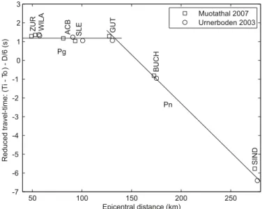
the routinely determined location puts the hypocenter at a depth of 0 km. the closest station (muO) is situated 10 km from the epicenter. consequently, this focal depth is constrained only by the travel times along the rays refracted in the upper crust and in the upper mantle, and is very sensitive to the 3D velocity model used by the location algorithm. As an indepen-dent check of the focal depth, we compared the observed travel times of this earthquake with those for an event that occurred in 2003 near urnerboden, 11 km to the east and 4 km to the south of muotathal. the focal depth of the urnerboden event was determined to be 3 ± 1 km by comparison with the Linthal event of 2001, that in turn is well-constrained by P- and s-ar-rivals observed at a strong-motion instrument 1 km from the epicenter (Deichmann et al. 2002 and 2004). As shown in fig-ure 3, the cross-over distance of the travel-time branches of the refracted rays in the upper crust (Pg) and in the upper mantle (Pn) are practically the same for the two events. this implies that the focal depths of the two events must also be similar. the slightly later arrival of the Pn phase at station sInD in figure 3 suggests, in fact, that the muotathal event could ac-tually be even slightly shallower than the 3 km determined
for the urnerboden event. thus, the hypocenter of this event was certainly located in the sediments, that are 5–6 km thick in this region (maurer & Ansorge 1992). for the construction of the faultplane solution, we fixed the depth at 2 km and calcu-lated the take-off angles with a 2D ray-tracing algorithm. the resulting focal mechanism is shown in figure 4 together with the optimal double-couple moment tensor derived from a full-waveform inversion of the seismograms observed at six stations located at epicentral distances between 28 and 81 km. both so-lutions correspond to a strike-slip mechanism with nnW–sse and ene–WsW striking nodal planes (table 3), which is very similar to the focal mechanism of the 2003 urnerboden event (Deichmann et al. 2004).
Judging from the almost identical seismograms (the lower four traces in figure 5), it was part of a small sequence of four events with the same source, that occurred between June 1st
fig. 3. Arrival times of the urnerboden event of 2003 and the muotathal event of 2007 observed at stations to the n of the epicenters. the data for the two events were aligned with respect to the arrivals of the waves refracted in the upper crust (Pg). the fact that the arrivals of the refractions at the moho (Pn) match for the two events implies that their focal depths are very similar.
50 100 150 200 250 -7 -6 -5 -4 -3 -2 -1 0 1 2 3
ZUR ACB GUT
BUCH SIND WILA SLE Epicentral distance (km) Reduced travel-time: (T i-To )-D/6 (s) Pg Pn Muotathal 2007 Urnerboden 2003
fig. 4. faultplane solution of the ML 3.0 muotathal event (above) and
opti-mal double-couple moment tensor based on a full-waveform inversion (be-low). the stereographs are lower hemisphere, equal area projections. solid circles and shaded quadrants correspond to compressive first motion (up); empty circles and white quadrants correspond to dilatational first motion (down).
Muotathal 2007.07.12
table 3. focal mechanism parameters based on first-motion polarities (lines with ML) and on an automated full-waveform inversion method (lines with Mw).
Location Date & time [utc]
Depth [km]
mag. Plane 1 Plane 2 strike/Dip/rake P-Axis t-Axis Az/Dip basel muotathal 2007/01/06 07:20 2007/07/12 00:09 4 2 5 ML 3.1 ML 3.0 Mw 2.9 091/79/-176 360/86/-011 076/82/-178 346/88/-008 080/88/-160 349/70/-002 315/11 046/05 301/07 031/04 306/15 213/13
and August 9th. As summarized by Deichmann et al. 2006 and documented in detail by Husen et al. 2007, during the heavy rainfalls in August 2005 this region witnessed a remarkable case of precipitation-induced seismicity, with 33 events occurring within 24 hours. contrary to what might have been expected, the sequence of 2007 does not correspond to a reactivation of the sources that were triggered by the rainfall two years earlier. this is illustrated by the two seismograms (top two traces in figure 5) that are typical for the two clusters that were active in 2005, and which differ significantly from those recorded in 2007. In fact, the epicenters of the four events recorded in 2007 lie roughly inbetween the riemanstalden and bisistal clusters of 2005.
château-d’Oex
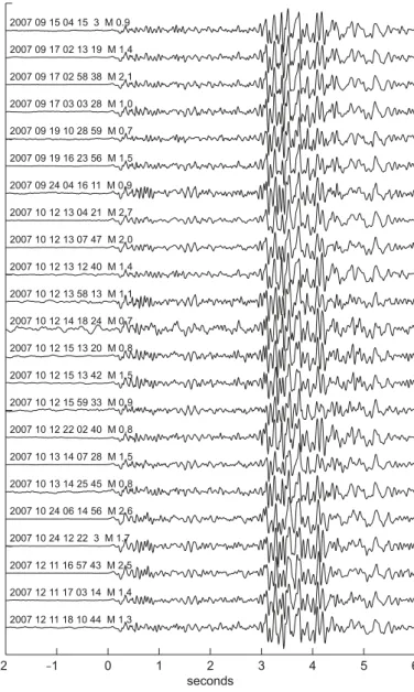
the most prolific single cluster to occur naturally in 2007 was located near the town of château-d’Oex. It consisted of 23 events with magnitudes ML between 0.7 and 2.7 that occurred between september 15th and December 11th. Almost half of them occurred within 26 hours, between October 12th and 13th. Judging from the striking similarity of the recorded seis-mograms shown in figure 6, the source and focal mechanism of all these events must have been nearly identical. However, even the records of the strongest event are not sufficient to construct a reasonably well constrained faultplane solution.
to improve the consistency of the measured arrival times across the whole sequence, we took advantage of the high signal similarity and applied a cross-correlation procedure to the P- and s- phases recorded at the four closest stations.
consequently, the calculated epicenter locations of the weaker events, that were recorded by only these four stations, form a point-like cluster in the epicenter map shown in figure 1. the systematic shift of this cluster relative to the location of the three stronger events is an artifact of the location procedure and is due to the fact that additional, more distant, arrivals were available for locating these events. In addition, given that the closest station to the epicenters is AIgLe at a distance of almost 20 km, the focal depth of about 10 km, listed in table 1 for the three ML≥ 2.5 events, is only constrained by a few Pn ar-rivals refracted at the moho. On the other hand, the computed focal depths of the weaker events, for which observations of Pn arrivals at large distances are lacking, put their hypocenters at the earth’s surface.
fig. 5. seismograms of two rain-induced events in the area of bisistal and riemenstalden during 2005 (above), and the four muotathal events of 2007 (below), recorded at station muO – n–s component, band-pass filtered 1–20 Hz. −2 −1 0 1 2 3 4 5 6 2005 08 22 23 20 12 M 2.3 2005 08 23 01 24 39 M 1.8 2007 06 01 01 41 57 M 2.0 2007 07 11 19 27 47 M 1.6 2007 07 12 00 09 35 M 3.0 2007 08 09 21 41 40 M 1.4 seconds
fig. 6. seismograms of the 23 events of the château-d’Oex sequence, recorded at station AIgLe – vertical component, band-pass filtered 1–20 Hz.
−2 −1 0 1 2 3 4 5 6 2007 09 15 04 15 3 M 0.9 2007 09 17 02 13 19 M 1.4 2007 09 17 02 58 38 M 2.1 2007 09 17 03 03 28 M 1.0 2007 09 19 10 28 59 M 0.7 2007 09 19 16 23 56 M 1.5 2007 09 24 04 16 11 M 0.9 2007 10 12 13 04 21 M 2.7 2007 10 12 13 07 47 M 2.0 2007 10 12 13 12 40 M 1.4 2007 10 12 13 58 13 M 1.1 2007 10 12 14 18 24 M 0.7 2007 10 12 15 13 20 M 0.8 2007 10 12 15 13 42 M 1.5 2007 10 12 15 59 33 M 0.9 2007 10 12 22 02 40 M 0.8 2007 10 13 14 07 28 M 1.5 2007 10 13 14 25 45 M 0.8 2007 10 24 06 14 56 M 2.6 2007 10 24 12 22 3 M 1.7 2007 12 11 16 57 43 M 2.5 2007 12 11 17 03 14 M 1.4 2007 12 11 18 10 44 M 1.3 seconds
Induced seismicity in basel
to stimulate the reservoir for a “hot dry rock” geothermal project, that was initiated by a private/public consortium in the city of basel, approximately 11500 m3 of water were injected
between December 2nd and 8th, 2006, at high pressures into a 5 km deep well below Kleinhüningen. As summarized by baer et al. (2007) and documented in detail by Häring et al. (2008), the microseismic activity induced by this procedure increased steadily until the evening of December 8th, when a magnitude
ML 3.4 earthquake occurred within the stimulated rock volume. At that time, water injection hat already been stopped; sub-sequently the well was opened and the water allowed to flow back. In the following days about one third of the injected wa-ter volume escaped the well, and the seismic activity declined rapidly thereafter (baer et al. 2007, Häring et al. 2008). How-ever, in the beginning of 2007 and although the water pressure at the wellhead had returned to near-normal levels, the seismic activity picked up again. this activity included four events with magnitudes ML between 2.8 and 3.2, that were clearly felt by the population (table 1).
the network of high-sensitivity borehole sensors, that had been installed by the operators of the project to monitor the stimulation, detected more than 14'000 events by the end of 2006 and an additional 1046 events during 2007. the hypocen-ters of the more than 3500 locatable events are restricted to a nnW–sse oriented lens-shaped cloud, about 1.2 km in dia-meter and 200 m wide, with a single offsetting branch to the ese (Häring et al. 2008). the center of this cloud is at a depth of about 4.5 km below ground level.
In 2007, a total of 30 events associated with the basel geo-thermal project were also recorded by the network of the swiss seismological service. their magnitudes (ML) range between 0.8 and 3.2. the sources of all these events are located in the upper sse corner of the hypocentral cloud.
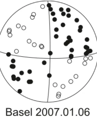
In figure 7 we show the faultplane solution of the first of the three events with ML >3. given the large number of sta-tions in the epicentral area and the good signals-to-noise ratio
fig. 7. faultplane solution of the ML 3.1 basel event. the stereograph is a
lower hemisphere, equal area projection in which solid circles correspond to compressive first motion (up) and empty circles to dilatational first motion (down).
Basel 2007.01.06
out to distances of almost 200 km, the solution is very well con-strained. the strike-slip mechanism with n–s and e–W striking nodal planes (table 3) is in excellent agreement with the stress field derived from the natural seismicity observed in the past in the wider basel region (Plenefisch & bonjer 1997, Kastrup et al. 2004). A detailed documentation of the 28 focal mechanisms available to date for the basel induced seismicity is in prepara-tion (Deichmann & ernst, 2009).
Discussion
In 2007, the total number of only 20 events with ML≥ 2.5 was below the 25 events per year observed on average over the pre-vious 32 years in this magnitude category. the activity low of 2007 is even more striking if one considers that four of these events are aftershocks induced by the geothermal reservoir stimulation in basel. thus the general trend of lower than
av-fig. 8. earthquake activity during 2007: magnitude of each event and cumula-tive number of events (above); histogram of magnitudes (below).
0 50 100 150 200 250 300 350 0 1 2 3 4 5 6 600 500 400 300 200 100 0 Cumulative number of event s Julian day Magnitude 2007 Magnitude Number of event s 120 100 80 60 40 20 0 0 1 2 3 4 5 2007
erage activity, that started in 2005, persisted through the year 2007.
As in previous years, most of the earthquakes occurred in the Valais and in graubünden. routinely calculated fo-cal depths for all but 14 events recorded in 2007 are less than 16 km. except for two events south of the Alps in or close to the Ivrea body, for which the routinely calculated depths are 19 and 25 km, all the deeper hypocenters are below the molasse basin and Jura of northern switzerland and southern germany. Acknowledgements
monitoring the seismicity in a small country is not possible without interna-tional cooperation. We thank W. brüstle and s. stange of the erdbebendienst des Landesamtes für geologie, rohstoffe und bergbau baden Württem-berg in freiburg, who kindly responded to our requests for information and data in 2007. Automatic data exchange in realtime has been implemented with the Zentralanstalt für meteorologie und geodynamik in Vienna, with the Istituto nazionale di geofisica e Vulcanologìa in rome and with the Zivilschutz der Autonomen Provinz bozen-südtirol. Access to the data of the borehole sensors in basel was granted by geopower basel Ag, and we thank in particular u. schanz and t. spillmann, geothermal explorers Ltd, for their help. We are also very grateful to our colleagues in the electronics lab, ch. bärlocher, m. grieder, b. rinderknecht, t. stalder, J. Zollinger and P. Zweifel, for their relentless efforts in ensuring the continuous reliabil-ity of the data acquisition systems and to A. blanchard for logistic support. financial support from the nationale genossenschaft für die Lagerung ra-dioaktiver Abfälle, nagra, for the operation of the stations in northeastern switzerland, as well as from the bLs Alptransit Ag for the operation of the two stations near Leukerbad and from Alptransit-gotthard Ag for the network around the southern segment of the new gotthard tunnel is grate-fully acknowledged.
references
baer, m., Deichmann, n., fäh, D., Kradolfer, u., mayer-rosa, D., rüttener, e., schler, t., sellami, s., smit, P. 1997: earthquakes in switzerland and sur-rounding regions during 1996. eclogae geologicae Helvetiae 90/3, 557– 567.
baer, m., Deichmann, n., ballarin Dolfin, D., bay, f., Delouis, b., fäh, D., giar-dini, D., Kastrup, u., Kind, f., Kradolfer, u., Künzle, W., röthlisberger, s., schler, t., sellami, s., smit, P., spühler, e. 1999: earthquakes in switzer-land and surrounding regions during 1998. eclogae geologicae Helvetiae, 92/2, 265–273.
baer, m., Deichmann, n., braunmiller, J., ballarin Dolfin, D., bay, f., bernardi, f., Delouis, b., fäh, D., gerstenberger, m., giardini, D., Huber, s., Kastrup, u., Kind, f., Kradolfer, u., maraini, s., mattle, b., schler, t., salichon, J., sellami, s., steimen, s., Wiemer, s. 2001: earthquakes in switzerland and surrounding regions during 2000. eclogae geologicae Helvetiae, 94/2, 253–264.
baer, m., Deichmann, n., braunmiller, J., bernardi, f., cornou, c., fäh, D., giar-dini, D., Huber, s., Kästli, P., Kind, f., Kradolfer, u., mai, m., maraini, s., Oprsal, I., schler, t., schorlemmer, D., sellami, s., steimen, s., Wiemer, s., Wössner, J., Wyss, A. 2003: earthquakes in switzerland and surrounding regions during 2002. eclogae geologicae Helvetiae – swiss Journal of geosciences, 96/2, 313–324.
baer, m., Deichmann, n., braunmiller, J., Husen, s., fäh, D., giardini, D., Kästli, P., Kradolfer, u., Wiemer, s. 2005: earthquakes in switzerland and surrounding regions during 2004. eclogae geologicae Helvetiae – swiss Journal of geosciences, 98/3, 407–418.
baer, m., Deichmann, n., braunmiller, J., clinton, J., Husen, s., fäh, D., giar-dini, D., Kästli, P., Kradolfer, u., Wiemer, s. 2007: earthquakes in switzer-land and surrounding regions during 2006. swiss Journal of geosciences, 100/3, 517–528.
Deichmann, n. 1990: seismizität der nordschweiz, 1987–1989, und Auswer-tung der erdbebenserien von günsberg, Läufelfingen und Zeglingen. nagra technischer bericht, ntb 90–46, nagra, baden.
Deichmann, n., baer, m., ballarin Dolfin, D., fäh, D., flück, P., Kastrup, u., Kradolfer, u., Künzle, W., mayer-rosa, D., röthlisberger, s., schler, t., sellami, s., smit, P., & giardini, D. 1998: earthquakes in switzerland and surrounding regions during 1997. eclogae geologicae Helvetiae 91/2, 237–246.
Deichmann, n., baer, m., braunmiller, J., ballarin Dolfin, D., bay, f., Delouis, b., fäh, D., giardini, D., Kastrup, u., Kind, f., Kradolfer, u., Künzle, W., röth-lisberger, s., schler, t., salichon, J., sellami, s., spühler, e., Wiemer, s. 2000a: earthquakes in switzerland and surrounding regions during 1999. eclogae geologicae Helvetiae, 93/3, 395–406.
Deichmann, n., ballarin Dolfin, D., Kastrup, u. 2000b: seismizität der nord- und Zentralschweiz. nagra technischer bericht, ntb 00-05, nagra, Wet-tingen.
Deichmann, n., baer, m., braunmiller, J., ballarin Dolfin, D., bay, f., bernardi, f., Delouis, b., fäh, D., gerstenberger, m., giardini, D., Huber, s., Kradolfer, u., maraini, s., Oprsal, I., schibler, r., schler, t., sellami, s., steimen, s., Wiemer, s., Wössner, J., Wyss, A. 2002: earthquakes in switzerland and surrounding regions during 2001. eclogae geologicae Helvetiae – swiss Journal of geosciences, 95/2, 249–261.
Deichmann, n., baer, m., braunmiller, J., cornou, c., fäh, D., giardini, D., gisler, m., Huber, s., Husen, s., Kästli, P., Kradolfer, u., mai, m., maraini, s., Oprsal, I., schler, t., schorlemmer, D., Wiemer, s., Wössner, J., Wyss, A. 2004: earthquakes in switzerland and surrounding regions dur-ing 2003. eclogae geologicae Helvetiae – swiss Journal of geosciences, 97/3, 447–458.
Deichmann, n., baer, m., braunmiller, J., Husen, s., fäh, D., giardini, D., Kästli, P., Kradolfer, u., Wiemer, s. 2006: earthquakes in switzerland and surrounding regions during 2005. eclogae geologicae Helvetiae – swiss Journal of geosciences, 99/3, 443–452.
Deichmann, n. & ernst, J. 2009: earthquake focal mechanisms of the induced seismicity in 2006 and 2007 below basel (switzerland). swiss Journal of geoscience, (submitted).
Dreger, D. s. 2003: tDmt InV: time Domain seismic moment tensor In-Version. In W. H. K. Lee, H. Kanamori, P. c. Jennings, and c. Kisslinger (eds.), International Handbook of earthquake and engineering seismol-ogy, Volume b, pp. 1627.
fäh, D., giardini, D., bay, f., bernardi, f., braunmiller, J., Deichmann, n., fur-rer, m., gantner, L., gisler, m., Isenegger, D., Jimenez, m.-J., Kästli, P., Ko-glin, r., masciadri, V., rutz, m., scheidegger, c., schibler, r., schorlem-mer, D., schwarz-Zanetti, g., steimen, s., sellami, s., Wieschorlem-mer, s., Wöss-ner, J. 2003: earthquake catalog of switzerland (ecOs) and the related macroseismic database. eclogae geologicae Helvetiae – swiss Journal of geosciences, 96/2, 219–236.
giardini, D., Wiemer, s., fäh, D., Deichmann, n., sellami, s., Jenni, s. and the Hazard team of the swiss seismological service 2004: seismic Hazard Assessment 2004. swiss seismological service, 81 pp.
Häring, m. O., schanz, u., Ladner, f., Dyer, b. c. 2008: characterization of the basel 1 enhanced geothermal system. geothermics (2008), doi:10.1016/ j. geothermics 2008.06.002.
Husen, s., Kissling, e., Deichmann, n., Wiemer, s., giardini, D., baer, m. 2003: Probabilistic earthquake location in complex three-dimensional velocity models: Application to switzerland. J. geophys. res., 108, b2, 2077–2096. Husen, s., bachmann, c., giardini, D. 2007: Locally triggered seismicity in the central swiss Alps following the large rainfall event of August 2005. geo-physical Journal International 171, 1126–1134.
Kastrup, u., Zoback m.-L., Deichmann, n., evans, K., giardini, D., michael, A.J. 2004: stress field variations in the swiss Alps and the northern Al-pine foreland derived from inversion of fault plane solutions. Journal of geophysical research 109, b1.
Kastrup, u., Deichmann, n., fröhlich, A., giardini, D. 2007: evidence for an active fault below the northwestern Alpine foreland of switzerland. geo-physical Journal International, 169, 1273–1288.
Kradolfer, u. & mayer-rosa, D. 1988: Attenuation of seismic waves in switzer-land. In: recent seismological investigations in europe. Proceedings of the XIX general Assembly of the esc. moscow, October 1–6, 1984, 481–488.
Lomax, A., Virieux J., Volant P., thierry-berge, c. 2000. Probabilistic earth-quake location in 3D and layered models. In Advances in seismic event Location, edited by c.H. thurber, and n. rabinowitz, Kluwer Academic Publishers, Dordrecht/boston/London, pp. 101–134.
maurer, H. & Ansorge, J. 1992: crustal structure beneath the northern margin of the swiss Alps. tectonophysics 207, 165–181.
Pavoni, n. 1977: erdbeben im gebiet der schweiz. eclogae geologicae Hel-vetiae 70/2, 351–370.
Pavoni, n. & roth, P. 1990: seismicity and seismotectonics of the swiss Alps. results of microearthquake investigations 1983–1988. In: Deep structure of the Alps. (ed. by f. roure, P. Heitzmann and r. Polino). mémoire de la socitété géologique de france, n. s., 156, 129–134.
Pavoni, n., maurer, H., roth, P., Deichmann, n. 1997: seismicity and seis-motectonics of the swiss Alps. In: Deep structure of the swiss Alps, results of nrP 20, birkhäuser, basel, 241–250.
Plenefisch, t. & bonjer, K.-P. 1997: the stress field in the rhinegraben area inferred from earthquake focal mechanisms and estimation of frictional parameters. tectonophysics, 275, 71–97.
rüttener, e. 1995: earthquake hazard estimation for switzerland. matér. géol. suisse, geophys. nr. 29, schweizerische geophysikalische Kom-mission, etH-Zürich, 101 pp.
rüttener, e., eogozcue, J., mayer-rosa, D., mueller, s. 1996: bayesian estimation of seismic hazard for two sites in switzerland. natural Hazards 14, 165–178. sägesser & mayer-rosa 1978: erdbebengefährdung in der schweiz.
schweize-rische bauzeitung 78/7, 3–18. manuscript received October 25, 2008 revision accepted november 10, 2008 Published Online first: December 13, 2008 editorial Handling: stefan bucher