HAL Id: hal-01662646
https://hal.archives-ouvertes.fr/hal-01662646
Submitted on 7 May 2018
HAL is a multi-disciplinary open access
archive for the deposit and dissemination of
sci-entific research documents, whether they are
pub-lished or not. The documents may come from
teaching and research institutions in France or
abroad, or from public or private research centers.
L’archive ouverte pluridisciplinaire HAL, est
destinée au dépôt et à la diffusion de documents
scientifiques de niveau recherche, publiés ou non,
émanant des établissements d’enseignement et de
recherche français ou étrangers, des laboratoires
publics ou privés.
Lateglacial-Holocene abrupt vegetation changes at Lago
Trifoglietti in Calabria, Southern Italy: The setting of
ecosystems in a refugial zone
Jacques-Louis de Beaulieu, Elisabetta Brugiapaglia, Sebastien Joannin,
Frédéric Guiter, Giovanni Zanchetta, Sabine Wulf, Odile Peyron, Liliana
Bernardo, Julien Didier, Agnès Stock, et al.
To cite this version:
Jacques-Louis de Beaulieu, Elisabetta Brugiapaglia, Sebastien Joannin, Frédéric Guiter, Giovanni
Zanchetta, et al.. Lateglacial-Holocene abrupt vegetation changes at Lago Trifoglietti in Calabria,
Southern Italy: The setting of ecosystems in a refugial zone. Quaternary Science Reviews, Elsevier,
2017, 158, pp.44 - 57. �10.1016/j.quascirev.2016.12.013�. �hal-01662646�
Lateglacial-Holocene abrupt vegetation changes at Lago Trifoglietti in Calabria,
Southern Italy: The setting of ecosystems in a refugial zone
Jacques-Louis de Beaulieu
a
,
*
, Elisabetta Brugiapaglia
b
, Sebastien Joannin
c
,
Frederic Guiter
a
, Giovanni Zanchetta
d
, Sabine Wulf
e
,
f
, Odile Peyron
c
, Liliana Bernardo
g
, Julien
Didier
h
, Agnes Stock
h
, Damien Rius
h
, Michel Magny
h
aAix Marseille Univ, CNRS, IRD, IMBE, UMR 7263 & 237, Aix-en-Provence, France
bUniversita degli Studi del Molise, Dipartimento di Agricoltura, Ambiente e Alimenti, Campobasso, Italy cCNRS UMR 5554, ISEM, Universite de Montpellier, Montpellier, France
dDipartimento di Scienze della Terra, Universita di Pisa, Italy
eSenckenberg Research Institute and Natural History Museum, BIK-F, TSP6 Evolution and Climate, Frankfurt/Main, Germany fInstitute of Earth Sciences, Heidelberg University, Germany
gDipartimento DiBEST, Universita della Calabria, Italy
hLaboratoire Chrono-Environnement UMR 6249 du CNRS, UFR des Sciences et Techniques, Besançon, France
Keywords: Lake sediments Calabrian Mountains Lago Trifoglietti Pollen record LGI-early Holocene Preboreal oscillation Tephrochronology Glacial refuges
a b s t r a c t
Retrospective science such as palaeoecology deeply depends on the preservation of archives in sensitive places. As an example, mountains of medium altitude from Mediterranean peninsulas have long been identified by biogeographers as refuges zones allowing the survival of European temperate taxa during the ice ages, but archives to validate this hypothesis are scarce, especially in Southern Italy. Here we present a new sequence from Lago Trifoglietti (1048 m a.s.l.) in the Calabrian Mountains, which covers
the Late Glacial Interstadial (LGI, corresponding to the Bolling€-Allerod€ period in northern-central Europe) and the transition to the Holocene. The independent chronology based on seven radiocarbon dates is supported by the evidence of three tephra layers already identified in other regional sequences. During the LGI, besides the high diversity of non arboreal pollen grains, a great number of pollens of temperate forest trees are present or abundant (mostly deciduous oaks and fir). These assemblages suggest that the site was above but not far from the upper limit of diversified woodland stands. They confirm a local survival during the last glacial. The Younger Dryas is not marked by major changes, and oak percentages are even higher, suggesting a resilient expansion at lower altitude. Surprisingly the site remains above the timberline until an aridity crisis centered at 11,100 cal 14C yr PB, which is correlated with the Pre-boreal Oscillation (PBO). This event is immediately followed by the local settlement of a dense fir and beech forest around the lake. A comparison with other Italian key sequences aims at explaining the climate forcing factors that governed this original vegetation dynamic. Further investigations using additional proxies are needed for a more robust climate reconstruction.
* Corresponding author.
E-mail addresses: jacques-louis.debeaulieu@orange.fr (J.-L. Beaulieu), e.
brugiapaglia@unimol.it (E. Brugiapaglia), sebastien.joannin@univ-montp2.fr (S. Joannin),
frederic.guiter@imbe.fr (F. Guiter), zanchetta@dst.unipi.it (G. Zanchetta),
Sabine.Wulf@geow.uni-heidelberg.de (S. Wulf), odile.peyron@univ-montp2.fr (O.Peyron),
l.bernardo@unical.it (L. Bernardo), Julien.Didier@ univ-fcomte.fr (J. Didier),
agnes.stock@univ-fcomte.fr (A. Stock), Damien.Rius@ univ-fcomte.fr (D. Rius),
Michel.Magny@univ-fcomte.fr (M.Magny).
http://dx.doi.org/10.1016/j.quascirev.2016.12.013 0277-
1. Introduction
The Lateglacial to Holocene transition constitutes a key period for the setting of temperate ecosystems, from which the present landscape is inherited. This is particularly true in the Mediterra-nean peninsulas whose role as refugial zones during the glacial times has been evidenced both by
palaeoecological and phylo-geographical studies (Hewitt, 2011). One can
expect a two dimen-sional expansion (i.e. altitudinal and latitudinal) of temperate forest starting during the Lateglacial Interstadial (LGI) or quickly
J.-L. Beaulieu et al. /
following the postglacial warming, without significant lags due to migrations from more distant refuges. Nevertheless these dynamics cannot be fully understood without palaeo-data providing knowl-edge about the period corresponding to the setting of the Late-glacial warming. Unfortunately this period is poorly documented in Southern Italy, with the exception of the
record obtained from the site of Lago Grande di Monticchio (Huntley et al.,
1999; Allen et al.,2002)(Fig. 1). In Calabria a pollen study of the sediment
infill of theMountain lake of Trifoglietti constitutes a promising target to fill
this gap. The study of a first coring from this site has recently provided a reconstruction of the local vegetation and hydrological changes since ca. 11,500 cal yr BP within a more extensive project focussing on the Central
Mediterranean area (Joannin et al., 2012;Magny et al., 2013, Peyron et al.,
2013). The sequence shows aphase characterized by open steppe vegetation
apparently contemporaneous with the Preboreal Oscillation (PBO) based on three radiocarbon dates; this event is followed by the expansion of beech-fir
woodland at ca. 11,000 14C cal yr BP. Such extremely arid event, never
evidenced before, was rather difficult to understand
without data for the preceding Lateglacial vegetation. A new coring campaign has been performed in autumn 2011, which allowed collecting a sequence beginning with the LGI and evidencing several tephra layers. The objectives of this study are fourfold as follow: 1/ to contribute in the description of the local environment history of Calabria during the Lateglacial, 2/ to establish the importance of this region as a possible refugium for temperate trees during the Lateglacial, 3/ to assess the regional impact of the Younger Dryas (YD) cold event, 4/ to test more robustly the regional significance and timing of the early Holocene, short-lived arid even (the ‘Trifoglietti event’), as a possible correlative of the PBO.
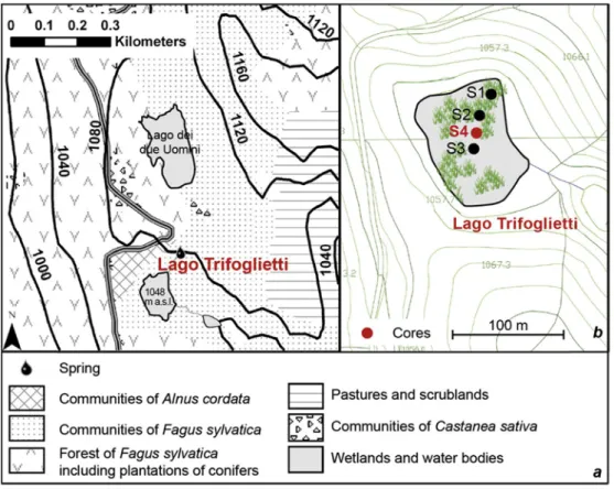
2. General description of the site 2.1. Location
Lago Trifoglietti (39 330N, 16 010E; 1048 m a.s.l.) is located in Calabria
(Southern Italy) (Fig. 1), near the town of Fagnano Castello in Cosenza
province. The lake, overlooked by Monte Caloria
Fig. 1. Location of the study site and other sites considered in the text: Lago Grande di Monticchio (Allen et al., 2002), Urio Quattrocchi (Bisculm et al., 2012), Lago di Pergusa (Sadoriand Narcisi, 2001),MD90-917 (Siani et al., 2012; Combourieu-Nebout et al., 2013),MD04-2797CQ (Desprat et al., 2013). Bioclimatic belts issued from Rivas Martinez's classification (1993),modified after
(1183 m), is part of a natural high-altitude lacustrine system in the Catena Costiera Mountains which stretch along and parallel to the Tyrrhenian coast
for 70 km with altitudes ranging from 1060 to 1541 m (Sperone et al., 2007).
The slope toward the sea is steep and thus the horizontal distance from the lake to the sea is only 16 km.
At Trifoglietti, a spring currently flows into the lake from the north; an
outflow runs southward (Fig. 2aeb). To combat summer drought and a
complete infilling, the Municipality of Fagnano Castello built a small earthen dam in 2000. With a surface area of 0.973 ha and a catchment area covering
0.370 km2, the lake, largely occupied by swamp vegetation, reaches a depth
of up to 1.50 m. The aquatic lake vegetation comprises a mosaic of different plant communities, with dominant Carex paniculata tussocks, partly linked with dynamic successions due to variations in water level. A detailed
description of the site is available in Joannin et al.(2012).
2.2. Climate and phytogeography 2.2.1. Climate
Due to its geographical position and to its relatively high elevation, the climate of the Trifoglietti region is greatly influenced by warm and humid air masses from the Tyrrhenian Sea. Despite the strictly Mediterranean latitude of the study area, annual rainfall can reach more than 1800 mm/year, with a
summer dry period relatively short (Ciancio, 1971). According to the
bioclimatic clas-sification proposed by Rivas-Martinez (1993) and based on
both a corrected summer ombrothermic index (Iovc) and a corrected thermic index (Itc), the Trifoglietti area falls within the “lower mesotemperate bioclimate belt” of a temperate region and the ombrotype is “upper hyperhumid”. Mean annual temperature is 15 C, with 24 C for August and 7.5 C for January.
2.2.2. Geology and phytogeography
Located at latitudes between 40 100 and 37 550 N and longitudes between
15 400 and 17 100 E, Calabria covers an area of 15.082 km2, half of it
consisting of hills up to 600 m a.s.l., and about 41% of mountains. The maximum altitude is reached by Mount Serra Dolcedorme (2267 m a.s.l.).
Calabrias's palaeobiogeographical history dates to the Palae-ozoic era and is extremely complex. Although the Calabrian mountains show an orographic continuity with the Apennine chain, there are remarkable geological differences between them. Almost the entire territory of Calabria consists of a large geological unit, called the Calabrian-Peloritan arc, which is lithologically and evolutionary completely different from the central
Apennines (Ogniben, 1973; Amodio-Morelli et al., 1976). This unit is
composed of sedimentary rocks of different ages and types. The backbone of the Calabrian-Peloritan arc consists of igneous and metamorphic rocks similar to the Corsica-Sardinia block, both derived from a portion of the western Alps. During the Miocene, the Calabrian-Peloritan arc migrated towards its current position; here, it wedged and partially overlaid the younger rocks of
the Apennines (Van Dijk et al., 2000). All these lithotypes produced a wide
variety of soils and plant communities; the latter thus simultaneously
belonging to the Temperate and Mediterranean bioclimatic regions (Blasi and
Michetti, 2007). According to Rivas Martinez's classifi-cation (1993), we can
distinguish four bioclimatic belts (Fig. 1; Spampinato et al., 2010)as follows.
- The Thermomediterranean belt (Tm), which embraces the coastal areas and low hills of the region. Here the woody com-munities are very thin and fragmented into small patches. They are represented by the evergreen-sclerophyllous maquis and, on particularly cool and shady slopes, by thermophilous deciduous
J.-L. Beaulieu et al. /
forests where Quercus virgiliana is typically occurring. Currently, a wide portion of this territory is occupied by crops, especially olive groves, besides urban infrastructures.
- The Mesomediterranean belt (Mm) shows a wide extension throughout the region and is positioned in altitudes between 200-400 and 800e1000 m. The vegetation consists of evergreen forests where Quercus ilex is dominant, especially on the southern steepest Tyrrhenian slopes (Serre and Aspromonte). On the other hilltops, thermophilous, deciduous forests with Q. virgiliana or, in cooler and moister conditions, with Q. frainetto prevail. - The Supramediterranean belt (Sm), between 800-1000 and 1100e1200 m
altitude, is well represented in the region, espe-cially on the Ionian side, and is characterized by deciduous oak forests consisting of various species, such as, above all, Quercus cerris and Q. frainetto, but also Q. congesta, Q. pubescens and
Q. dalechampii, in pure or mixed forests.
Quite often, the deciduous oak forests are replaced by cultivated Castanea sativa pure stands.
The most shaded and sunken valleys are characterized by forests with Ostrya carpinifolia, Acer spp., Carpinus betulus and Corylus avellana as prevailing species.
- In the Supratemperate belt (St) beech woods prevail on wide areas at an altitude ranging between 900-1000 m and 1900e2000 m, but descending down to 500e600 m along the narrow valleys of the Tyrrhenian side. On the Calabrian moun-tains, the beech woods may be ascribed to three distinct asso-ciations. The first, called Anemono-Fagetum, prevailing under 1500 m, is influenced by the oceanic climate and it is charac-terized by abundant undergrowth of Ilex aquifolium. The second is the Galio hirsuti-Fagetum, which mainly occurs, as requiring a less oceanic climate, on the southern and western side of the Aspromonte massif. From 1500 to 1600 m a.s.l. up to almost 2000 m the third association, the Campanulo trichocalicinae-Fagetum, is adapted to a colder climate, where beech trees reach their maximum altitudinal limit. In the various types of wood-lands, beech trees tend to form pure stands, although often associated with Abies alba, which generally has a subordinate role. Silver fir trees become dominant only on small areas of the Aspromonte, at about 1600 m, on windy, rocky peaks.
Native woodlands characterized by Pinus nigra ssp. laricio occur on crystalline tops (Sila and Aspromonte), between 1000 and 1400 m a.s.l., on steep and sunny slopes, where the soil is poor. However, nowadays this species is widespread on all the Calabrian mountains, thanks to its successful use as species for reforestation. In the most depressed areas of these highlands there are a few small wetlands, swamps and bogs of a great natural value, because they are propitious to the establishment of some boreal species at their southernmost distribution edge.
On Sila plateau, but also on Serre and Aspromonte the natural forests have been often removed and replaced by cereals and potato crops or by coniferous planting. Crop abandonment causes the spread of Sarothamnus scoparius, forming dense thickets.
Only on the Pollino massif, where a few peaks reach or exceed 2000 m of altitude, we can distinguish a timberline, above which there are the typical prairies and rocky communities of the Apen-nine high-mountain belt. In this context, the Bosnian pine (Pinus heldreichii var. leucodermis) has colonised steep rocky slopes.
The Catena Costiera vegetation is dominated by Fagus sylvatica, Quercus cerris and Castanea sativa.
Lake Trifoglietti is surrounded by a beech forest attributed to Anemonoapenninae-Fagetum with some Pinus nigra subsp. laricio.
Scrub vegetation, with Erica arborea, Cistus salvifolius, Helichrysum italicum, Sarothamnus scoparius and Alnus cordata trees, develops in the more open Fagus forests.
3. Material and methods 3.1. Core sampling
The 2009 study of the Lake Trifoglietti sequence demonstrated its palaeoecological importance and stimulated the present research, which extends the record into the Lateglacial.
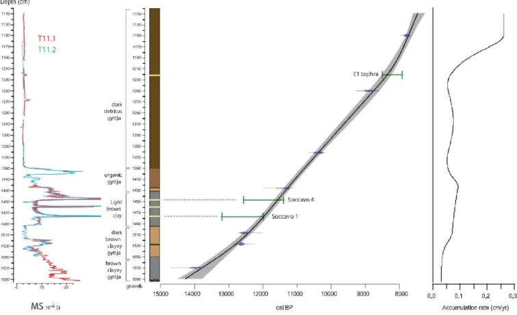
Fig. 2brecalls the transect of cores realized in 2009 (S1, S2, S3): the studied core was S2 (called here Trifo.09). In October 2011, a new coring was undertaken at a point S4 (approximately between S2 and S3 and labeled here Trifo.11), with the help of the Fagnano Castello local authority. Coring was carried out using a 1 m long Russian peat corer with an 8 cm diameter chamber. The upper 11 m of the peat sequence were discarded and core sections extracted from 11 m to the substratum at 15.95 m (coarse gravel layers) were retained for further analyses. As the tip of a Russian corer pene-trates ca. 10 cm below a core, the upper part of the next core is disturbed. Therefore, after the first core sequence (here named Trifo. 11.1) obtained, a parallel twin sequence (Trifo.11.2) was retrieved to allow a 'master core sequence' to be generated by matching key reference lithological horizons,
magnetic suscepti-bility variations and tephra markers (see below and Fig. 3).
Core segments were extracted on site, wrapped in plastic, transported and stored at 4 C at the University of Franche-Comte where lith-ological description, magnetic susceptibility measurements and sub-sampling for
pollen analysis, 14C measurements and tephra analyses were undertaken.
3.2. Magnetic susceptibility
The cores were photographed and logged with a GEOTEK Multi Sensor Core Logger in order to obtain geophysical measurements, scanning of lithology, measurements of magnetic susceptibility (MS) at 0.5 cm intervals. This study focuses on the master core constructed from the twin cores
(Trifo.11.1 and Trifo.11.2, Fig. 3).
The MS is mainly dependent on magnetite concentration in sediments. It was measured in electromagnetic units to determine the inorganic
allochtonous sediment content (Gedye et al., 2000). As the development of
pedogenesis under forest cover may have favored a mineral magnetic increase
in soils (Jong et al., 1998), low magnetic concentrations recorded in
sediments is to be expected during phases of stabilized vegetated slopes (Whitlock et al., 2011), while increased MS may be related to changes in
sediment sources and to erosive processes of soils (Vanniere et al., 2013).
Neverthe-less, when ferrimagnetic mineral concentration is low (magnetite and maghaemite), the value of MS may be largely influenced by diamagnetic
minerals (quartz, carbonates) (Thompson andOldfield, 1986).
3.3. Tephra study
Samples of macroscopic visible tephra layers were embedded in epoxy resin and screened for volcanic glass shard fragments using scanning electron microscopy (SEM). Energy-dispersive-spectrometry (EDS) analyses of glass shards were carried out us-ing an EDAX-DX micro-analyser mounted on a Philips SEM 515 at the Dipartimento di Scienze della Terra, University of Pisa, employing a 20 kV acceleration voltage, 100 s live time counting, 2100e2400 shots per second, and ZAF corrections (Z ¼ Atomic number correction, A ¼ Adsorbion correction, F ¼ Fluorescence correction). The ZAF correction procedure did not include natural or
Fig. 3. Magnetic Susceptibility (MS), lithology and age-depth model of the Trifoglietti. master core (MC) based on radiocarbon calibrated ages (AMS, see Table 1).
synthetic standards for reference, and this required the results to be normalized to a given value (which was chosen at 100%). We used two standards whose chemistry has been accurately obtained using XRF analyses and certified have been routinely analyzed in the Pisa laboratory: a trachyte
glass (CR1) and an Albite along with the Zagarbard scapolite (Marianelli and
Sbrana, 1998). To avoid alkali loss, especially Na, a window spot usually ca.
10
m
m wide was used. Due to the different shapes and sizes of glass shards,sometimes a smaller beam size had to be used. The use of smaller beam sizes obligate to reduce the size of the defocused beam and this could influence analytical data due to the complex combination of element mobility and
sample damage (Hunt and Hill, 2001). However, this was minimized by
analyzing many different shards from the same sample. No obvious differences were observed be-tween results from smaller and larger shards. Analytical precision was 0.5% for abundances higher than 15 wt%, 1% for abundances around 5 wt%, 5% for abundances of 1 wt%, and less than 20%
for abundances close to the detection limit, i.e. around 0.5 wt% (Marianelli
and Sbrana, 1998). Several trials for comparing the performance of the Pisa SEM-EDS with wave dispersion spectros-copy (WDS) have been extensively
discussed by Cioni et al. (1997),Marianelli and Sbrana (1998), Vogel et al.
(2010), Sulpizio et al. (2010) and Caron et al. (2010, 2012).
3.4. Chronology
The chronology is based on seven Accelerator Mass Spectrom-etry
(AMS) 14C ages measured on terrestrial organic material (Table 1) at Poznan
Radiocarbon Laboratory. Conventional 14C ages were calibrated using the
IntCal13 curve (Reimer et al., 2013) based on the 2
s
range interval. Sixsamples (composed of terrestrial macro-remains) were taken from the Trifo.11.1 cores and one from a
twin section of Trifo.11. 2 core (depth and corresponding depth on the master
section are reported in Table 1). The age-depth model (Fig. 3) has been
computed using the module R Clam of Blaauw(2010) basedon a
smooth-spline (smooth: 0.3). Timings derivedfrom the age-depth model are reported
in cal 14C yr BP (1950) with a two sigma error range, and positions of tephra
layers are pre-sented in the curve with their respective chronological intervals
according to the information in section 4.1.2. Ages have been extrapolated
beyond upper and lower dated levels.
3.5. Pollen analysis
Sediment samples of 1 cm3 of volume were treated both chemically (HCl,
KOH, HF, acetolysis) and physically (sieving) following standard procedures (Moore et al., 1991). Samples were taken at 10 cm resolution from 11 to 12 m (previously studied in-terval), and either 5 or 2.5 cm from 12 m to the base of the core. A sum of at least 300 terrestrial pollen grains was counted, excluding dominant terrestrial taxa. A total of 151 pollen samples were analyzed under light microscopes at a magnification of either 400 or 500. 178
pollen types were identified using photo atlases (Reille, 1992e1998; Beug,
2004) and reference collections. Oak pollen grains are always difficult to
determine at the species level and the great number of oak species growing in Calabria increases the risks of errors. We identified three pollen types (Quercus robur type, Quercus suber/cerris type and Quercus ilex type). But the morphologies of the two first types frequently overlap: on the di-agram (Fig. 4) there are merged as “deciduous oaks”. Percentages were calculated based on the total pollen sum. The number of spores and algae counted were added to the pollen sum when calculating their relative percentages. Other Non Pollen Paly-nomorphs (NPP) were explored, but their study is not completed
Table 1
Summary of radiocarbon dates obtained from the Trifo. 11 core (four dates from Trifo.09, in italics, illustrate the correlation between the two cores).
Sample code (Lab number) Nature of sample Core Master core depth (m) PAZ Uncalibrated 14C age (yr BP) Calibrated ages at two s range (cal 14C yr BP) Poz-64307 Twigs Trifo.11.1 11.50 T11-12 6930 ± 40 7677e7844
Poz-64308 Twigs Trifo.11.1 12.51 T11-12 8010 ± 50 8668e9016 Poz-64309 Twigs Trifo. 11.1 13.62 T11-8 9200 ± 50 10,247e10,496 Poz-50604 Twigs Trifo.11.1 14.26 T11-8 9900 ± 60 11,205e11,602 Poz-72557 Twigs Trifo.11.2 15.07 T11-4 10,560 ± 60 12,395e12,685 Poz-50605 Twigs Trifo.11.1 15.27 T11-3 10,670 ± 60 12,548e12,719 Poz-50606 Twigs Trifo. 11.1 15.70 T11-2 12,120 ± 80 13,765e14,171 Poz-33812 Twigs Trifo. 09 7.61 T-3a 9335 ± 60 10,290e10,710 Poz-33813 Twigs Trifo. 09 8.06 T-3a 9630 ± 60 10,760e11,190 Poz-41168 Twigs Trifo. 09 8.43 T-1 9850 ± 50 11,190e11,388 Poz-33836 Twigs Trifo. 09 8.43 T-1 9940 ± 60 11,220e11,690
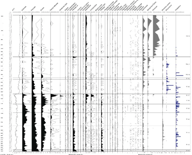
Fig. 4. Simplified pollen diagram of Lago Trifoglietti.
yet and the simplified pollen diagram will shows only Abies stomata and Asterosporium conidiae which are useful in the discussion.
Using the C2 program (Juggins, 2007), a pollen diagram of selected taxa
is provided in Fig. 4. Fig. 5 presents in more detail the non-arboreal pollen
(NAP) and algae. Rare taxa appear in Table 2. Subdivision into 12 biozones
(Pollen Assemblage Zones, PAZ: from T11-1 to T11-12) was defined by
cluster analysis based on the Coniss algorithm (Grimm, 1987) using the Rioja
package (Juggins,2012).
4. Results
4.1. Sediment and age/depth model 4.1.1. Lithology
Below the detritus gyttja deposits that are similar to those previously described for the S2 core are clay-gyttja deposits, not previously recorded from the Trifoglietti basin. In detail, the latter show the following lith-facies units from 11 m depth to the base of the recovered sequence:
- 11.00e13.97 m: dark detritus gyttja. Issued from an exploratory core, Fig.
6 shows the structure of this detritus gyttja, i.e. an accumulation of leaves
(here Fagus), Abies needles and wood fragments. A thin millimetric fine sand layer (identified as tephra 1) was observed at 12.20 m.
- 13.97e14.30 m: black clay gyttja including a succession of millimetric-scale organic layers between 14.20 m and 14.25 m.
- 14.30e14.95 m: light brown clay including three sandy layers at levels 14.44e45 m, 14.60 m and 14.77e78 m (the upper and the lower ones were identified as in situ tephra: see below).
- 14.95e15.50 m: dark brown clay-gyttja darkening towards the top, with a succession of millimetric-scale organic layers be-tween levels 15.10 m and 15.15 m.
- 15.50e15.95 m: brown clay-gyttja (sharp contact at 15.50 m), with sporadic white dots of vivianite between 15.10 m and 15.80 m.
- 15.95 m: top of a coarse gravel layer (limit of coring).
4.1.2. Tephra analyses
Fig. 5. Pollen diagram with algae.
Table 2
Rare pollen taxa occurring in the Trifoglietti 11 core.
TAXON Depth (m) Arcetobium oxycedri 15.15 Calligonum 15.53 Cerinthe 12.82 Cheylanthes 12.30e12.87 Cladium 13.72e13.60e13.52e13.45e13.35e12.88e11.60e11.30 Cynoglossum/Anchusa 14.40 Daphne 15.95e14.72 Epilobium 15.75e15.72e14.85 Erica terminalis 12.95 Euphorbia 15.82e15.72e15.65e15.35e14.55e14.17e13.40e12.12 Gentiana 15.82e15.72e15.22e14.48e14.37e13.85e12.52e11.32 Linum 15.77e15.33e15.32e15.15e14.65 Lysimachia 13.20e13.12e12.65e12.60e12.40e12.18e12.20 Pinguicula 15.20e14.65e14.50e11.30
Polypodium 11 samples above 13.30
Theligonum cynocrambe 12.75e13.07e15.37e15.72
J.-L. Beaulieu et a
Fig. 6. Photograph of detritus gyttja at 10.50 m sediment depth of Trifo.11 containing beech leaves.
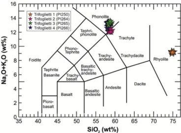
Fig. 7. Total Alkali e SiO2 diagram (Le Bas et al., 1986) for classifying tephra layers identified in the Trifoglietti core.
14.44e45 m, 14.60 m and 14.77e78 m composite depth and are labeled from the youngest to the oldest as Trifoglietti-1 to Trifoglietti-4, respectively.
According to the total Alkali vs SiO2 diagram (TAS diagram, Fig. 7; Le
Bas et al., 1986)tephra layer Trifoglietti-1 is a rhyolite,whereas Trifoglietti-2 and -3 are phonolites (Additional informa-tion 1). Trifoglietti-4 stands along the separation between phono-lite and trachyte fields (trachyphonolite). According to the chronological and stratigraphic position of Trifoglietti-1, the cor-relation is quite straightforward: at that time only one widespread rhyolite
tephra is known in the central Mediterranean and labeled by Paterne et al.
(1988) as “E1-tephra”. E1 is correlated with the Gabellotto/Fiumebianco activities of Lipari Island and is confirmed by comparison with other chemical
data in different marine cores (Siani et al., 2004; Caron et al., 2012; Marchini
et al., 2014). This tephra layer occurs within the interruption of Sapropel S1,
which has been correlated with the 8.2 ka cooling event (Siani et al., 2001,
2004; Zanchetta et al., 2011). Siani et al. (2001, 2004) obtainedaradiocarbon
age of 7770 ± 70 14C yr BP (8730e8400 cal 14C yr BP) on foraminifera from
Adriatic Sea core MD 90-917 co-registered with this cryptotephra. In core
MD 90-918, Caron et al. (2012) described this eruption as stratigraphically
younger than the Mercato erup-tion and gave a modeled age for the E1 tephra
of 8270 ± 50 cal 14C yr BP, which can be used as a reference age for the
chronology of
the Trifoglietti sequence.
The correlation of the other three phonolitic to trachyphonolitic tephras is more problematic. Considering their chronostratigraphic position in the Trifoglietti core within the end of the Late Glacial and the K-trachytic
composition with K2O/Na2O ratios>2 (e.g. Smith et al., 2011 andreferences
therein), we suggest a source of allthree tephra from the Campi Flegrei. At
least two violent eruptions with widespread tephra dispersal occurred during this period from the Campi Flegrei, i.e. the Neapolitan Yellow Tuff (NYT, ca
14,200 cal 14C yr BP; Siani et al., 2004; Bronk Ramsey et al., 2015) and the
Agnano Pomici Principali eruptions (APP, 12,037 ± 122 cal 14C yr BP; Di
Vito et al., 1999; Bronk Ramsey et al., 2015). However, thosetephra are mainly dispersed towards the NE, and glass composi-tions do not match the
chemical data of the Trifoglietti-2, -3 and -4 tephra layers (Fig. 8). Several
other Lateglacial to early Holocene, lower-scale eruptions occurred in-between and after these two major events, which are recorded in proximal
(e.g. Smith et al.,2011; Tomlinson et al., 2012)and distal sites (e.g. Wulf et
al., 2004, 2008). Comparing major element glass data of these tephrawith the Trifoglietti tephra, we can observe a good match of the younger, macroscopic visible Trifoglietti-2 tephra (sample ID: PI
264) with the Soccavo 4 tephra and the distal TM-6-4c crypto-tephra from
Lago Grande di Monticchio (Fig. 8). The Soccavo 4
eruption has not been directly dated yet, but is younger than the 12 ka APP
and older than the Pisani 3 (10,635 ± 120 cal 14C yr BP; DiVito et al., 1999)
eruptions. A better age estimate is provided bythe varve and sedimentation
rate interpolated age of Monticchio TM-6-4c tephra at 11,980 ± 600 varve yr BP (Wulf et al., 2008). Due to the large dating error, however, this age has not been incorpo-rated into the Trifoglietti age model. The oldest Trifoglietti-4 tephra layer (sample ID: PI265) shows a similar chemical composition as the Soccavo 1 tephra and Monticchio cryptotephra TM-7-1 (12,590 ± 630
varve yr BP; Wulf et al., 2008). The sub-Plinian Soccavo 1 eruption from the
Campi Flegrei has dispersed tephra
towards the Southern Tyrrhenian Sea (Albert et al., 2012) and is well dated at
12,198 ± 112 cal 14C yr BP (Di Vito et al., 1999; BronkRamsey et al., 2015),
therewith providing another excellent time and correlation marker.
Cryptotephras Trifoglietti-3 (sample ID: PI
266) is stratigraphically younger than tephra Trifoglietti-4 and re-veals a similar glass composition. We interpret this tephra as reworked material of the primary Trifoglietti-4 tephra.
Fig. 8. Chemical bi-variate plot CaO versus FeO for discriminating phonolitic and trachyphonolitictephras from the Trifoglietti core.
4.1.3. Age-depth model
The age-depth model (Fig. 3) is based on the seven calibrated 14C dates of
Trifoglietti organic matter and two tephra ages (E1 and Soccavo 1), while the independently-determined Monticchio varve age of the Soccavo 4 tephra is recorded on the curve. It should be noted that (1) the curve is well-constrained
by the 14C and tephra dates, without any reversal or stratigraphical
inconsistency and (2) that the age-model overlaps the age estimate of the
Soccavo 4 tephra, as defined in section 4.1.2. As a result, the chronological
framework at Trifoglietti is considered robust, suggesting sedi-mentation rates
between 0.4 and 1.46 mm yr 1 during the Late-glacial/early Holocene (Fig. 3).
Furthermore, the 14C-based age model provides an independent age estimate
for the Soccavo 4 eruptions at 11,700 ± 150 cal 14C yr BP, respectively.
4.1.4. Changes in magnetic susceptibility (MS)
Changes in magnetic susceptibility (MS) values suggest two major phases. The lower part of the sediment sequence below level 13.90 m (10,900
cal 14C yr BP) is characterized by strong variations in MS values, which
reflect instability of environmental and cli-matic conditions. Two large peaks indicate the position of Late-glacial tephra layers. A third one, at 14.60 m, corresponds to reworked Trifoglietti-3 tephra, indicating a short phase of erosion. The upper part of the sediment sequence shows low and quite constant MS values suggesting relatively stable environmental and climatic conditions in comparison to the preceding phase. The early Holocene Trifoglietti-1 tephra layer coincides with a small peak of MS values.
4.2. The pollen record
4.2.1. Brief description of pollen zones
As mentioned above, the summary pollen diagrams (Figs. 5 and6)do not
present the complete list of identified taxa, which isavailable on the EPD web
site (http://www. europeanpollendatabase.net). The diagram is constructed
using adepth scale, and the ages derived from the age/depth model appear to
the left of the log. Twelve pollen assemblages zones (PAZ) from T11-1 to T11-12 are identified.
T11-1 (15.96e15.89 m; ca 14,600e14,100 cal 14C yr BP): This PAZ is
characterized by high NAP percentages, mostly Poaceae, Arte-misia, Plantago, Galium, Chenopodiaceae, and Rumex. Among the trees, oak is dominant. Cupressaceae (most probably Juniperus), Pinus, Abies are present, but also mesophilous taxa occur (Fraxinus, Ulmus, Tilia, Hedera).
T11-2 (15.89e15.52 m; ca 14,100e13,350 cal 14C yr BP): Arboreal
pollen (AP) values increase up to ca 60% (mainly Quercus and Abies, but also Ulmus, Tilia, Corylus, Fraxinus ornus, Ostrya, and evergreen oaks). Poaceae, Artemisia and steppe elements (Ephedra) are still abundant.
T11-3 (15.52e15.03 m; ca 13,350e12,360 cal 14C yr BP): There are no
great changes in the pollen assemblages except for an in-crease in Rumex and monolete spores. In the upper part of the zone, a slight increase of Betula percentages is visible.
T11-4 (15.03e14.57 m; ca 12,360e11,770 cal 14C yr BP): Quercus
reaches its highest percentages, whereas Juniperus, Artemisia and steppe elements are more abundant. Tilia and Ulmus are scarce.
T11-5 (14.57e14.27 m; ca 11,770e11,420 cal 14C yr BP): This zone is
marked by a maximum in Betula percentages. Abundances in Artemisia and Juniperus decrease.
T11-6 (14.27e14.01 m; ca 11,420e11,110 cal 14C yr BP): Betula
decreases, Alnus percentages increase, and Poaceae and Rumex reach their maximal values. The first occurrence of Abies stomata and a short temporary Abies maximum (toward ca.10%) suggest some stands of this tree have approached the lake.
T11-7 (14.01e13.91 m; ca 11,110e10,945 cal 14C yr BP): This zone is
marked by a strong NAP increase with original assemblages including abundant Compositae, Caryophyllaceae and Heli-anthemum. A single level with a Centaurea maximum at 26% is observed.
T11-8 (13.91e13.38 m; ca 10,945e10,030 cal 14C yr BP): An abrupt
expansion of mountain trees (Fagus and Abies) occurs above 13.75 m. Abies stomata are regularly present, while Ostrya shows the beginning of a continuous curve. Among various NAP, Poaceae are the only taxa with percentages that remain high (around 10%).
T11-9 (13.38e13.32 m; ca 10,030e9950 cal 14C yr BP): This is a short
zone marked by a decrease in Quercus percentages to the benefit of Fagus.
T11-10 (13.32e13.11 m; ca 9950e9600 cal 14C yr BP): Fagus and AP
recede, and Quercus stabilizes around 20%. Ostrya percentages attain a maximum value above 10%. Taxus pollen is present.
T11-11 (13.11e12.58 m; ca 9600-8915 cal 14C yr BP): Quercus
percentages decline to ca 10%, while Ulmus is more abundant.
T11-12 (12.58e11.10 m; ca 8915-7590 cal 14C yr BP): Ulmus de-clines,
and Osmunda starts its expansion. Above 12 m, less abun-dant Poaceae could identify a subzone.
4.2.2. Rare pollen taxa
Beside the set of abundant pollen grains whose variations determine the
succession of zones they are rare pollen taxa (Table 2) whose present ecology
may contribute to refine the un-derstanding of the past landscapes. An exploration of this present ecology and distribution in Calabria and around is given in on-line Additional information 2. We can already distinguish two series of taxa. The first occurs in the lower part of the sequence (from T11-1 to T11-7) and includes Arcetobium oxycedri, Calligonum, Cerinthe, Daphne, Cynoglossum/ Anchusa, Epilobium, Euphorbia, Gentiana and Gentianella, Linum, Pinguicula, and Theligonum cynocrambe and the second above T11-7 and encompasses the following taxa: Chei-lanthes, Cladium, Erica terminalis, Lysimachia, Polypodium, and Vitis vinifera. This distribution is linked with the change from clay-gyttja to detritus gyttja.
5. Discussion
5.1. An attempt to combine age-depth model, sediments changes and vegetation dynamics
5.1.1. Chronological framework
According to the Trifoglietti age model (Fig. 3), the vegetation dynamics
reflected in the pollen diagram can be easily related to climate events defined
elsewhere in Southwest Europe (Beaulieuet al., 2005). If we follow the
chronological framework proposedin Fig. 4, PAZ T11-1, with a rather high
amount of steppe elements, corresponds to the Oldest Dryas/LGI transition. PAZ T11-2 and a part of PAZ T11-3 correspond to the LGI; the upper part of PAZ T11-3 and PAZ T11-4 coincides with the Younger Dryas (YD). Here we consider the YD as a chronozone and accept the age of respectively 12,850 14
C cal BP and 11,700 14C cal BP for its beginning and its end, following the
Greenland ice cores chronology (Rasmussen et al.,2006). It is the reason why
the YD lower limit does not exactlycoincide with the T11-3/T11-4 boundary.
This discrepancy cannot be used to suggest that the YD cooling may be time transgressive due to the imprecision of the present Trifoglietti age model.
The early Holocene which starts with the expansion of Betula in PAZ T11-5; PAZ T11-6 will be discussed below. The PAZ T11-7 to T11-12 may be correlated with the lower part of the pollen sequence Trifo.09, already
published by Joannin et al. (2012).
The correlation between Trifo.11 and Trifo.09 is based on MS, 14C dates
J.-L. Beaulieu et
NAP just before the setting of the beech-fir forest is identical to PAZ T09.2 in
Joannin et al. (2012), well dated by three 14C ages (Table 1). This common interval can be clearly correlated with the Preboreal Oscillation (PBO) whose
age is fixed at 11,350e11,150 cal 14C yr BP (Mayewski et al., 2004). In
addition, the MS curve (Fig. 3) may contribute to refine this chronology: here
we assume that periods with a higher susceptibility reflecting high terrigenous influx and/ or lower biogenic productivity in the lake are due to periods of cooling with decreasing vegetation cover (the susceptibility peaks due to tephra layers are excluded). Thus, the high MS values at the base of the sequence are in agreement with the attribution to the end of Oldest Dryas. The following drop in susceptibility corre-sponds to an increase in arboreal pollen ratio, but immediately after, a second maximum is linked with a decline in AP percentages (mostly Abies): this short event, not identified as a pollen zone,
could correspond to the Aegelsee oscillation (Lotter et al., 1992) at ca 13,960
cal 14C yr BP in good agreement with the Trifoglietti age model. After a
progressive decline in AP pollen toward a minimum at 15.35 m, a new maximum occurs between 15.30 m and 15.17 m: this event occurring in the middle part of PAZ T11-3 is not marked by any clear change in the pollen assemblage, but could correspond to the Gerzensee oscillation at ca 13,030
cal 14C yr BP (Van Radenet al., 2013). This hypothesis remains within the
error bars of theTrifoglietti age model. Moreover, following the MS peak at
15.17e14.94 m, the very low MS value is in agreement with an attribution of the upper part of PAZ T11-3 to the end of the LGI. A new increase in MS values at 14.94 m, coinciding with a clear lithological change is the signature of the starting YD slightly above the PAZ T11-3/T11-4 transition. Thus, along the Lateglacial/Holo-cene transition, the data obtained from the Trifoglietti sediment sequence suggest that the MS appears to have been generally more sensitive to short term (secular) climate oscillations than pollen data.
5.1.2. The Lateglacial interstadial
All along the LGI, the arboreal pollen percentages are stabilized between 50% and 60%, suggesting the site to be not very far from the timberline under an open landscape. The most abundant tree pollen types are deciduous oaks and fir. Among deciduous oak pollen grains we can assume that Quercus cerris woodstands were present at lower latitude at least since the LGI. If we
refer to the Abies pollen rains nowadays (Joannin et al., 2012), the
percentages of this tree (up to 25% in PAZ T11-2) suggest that it could be present in the immediate vicinity of the lake, but the absence of macro-remains and stomata lead us to propose scattered stands in the surrounding, or populations on the mountain slopes at lower altitude.
Another characteristic of the Lateglacial pollen spectra is the occurrence of a large panel of mesophillous arboreal taxa: the whole elements of the “Quercetum mixtum”, Fraxinus ornus, Fagus whose occurrences increase during T11.3. Mediterranean xero-phytic taxa are also present but with low percentages suggesting that they were restricted to a thin zone near the coast. This diversity reflects an original status of the Catena Costiera (middle mountain range characterized by high precipitation rates) as a refugial zone,
which is conforming to the model proposed by Beug (1976). The quasi
absence of Pinus is surprising: Pinus nigra subsp. laricio is nowadays very common on the Sila Massif, not far from the Trifo-glietti lake, while scattered populations of Pinus heldreichii var. leucodermis, growing on the Pollino mountain chain, are considered as the relicts of larger forests. Here, their absence could be due to an unfavorable substratum. Among the occasional taxa, Cedrus pollen grains are identified several times during the LGI (and the upper part of the YD): they correspond to distant transport from North Africa; a pollen grain of Calligonum (T11-2), a sub-Saharan taxon,
confirm this transport by winds from Africa, observed elsewhere in
Lateglacial records from south Europe (Beaulieu, 1977) even if the juniper
percentages are low. Among NAP, Poaceae and Rumex are the more abundant, suggesting an environment with subalpine meadows; a pollen grain of Arcetobium oxycedri (T11-2), parasitic on Juniperus also testifies on the local presence of shrub stands around the lake. NAP taxa are extremely diverse: beside steppe elements there are also taxa that are characteristic for wet meadows (Filipendula, Sanguisorba officinalis, Lysimachia). Mono-lete spores that are abundant during the LGI also suggest wet and shady surrounding. This rare juxtaposition may be explained by the particular topography of the slopes surrounding Lago Trifoglietti. They are most probably formed by a huge landslide generating closed depressions, hillocks and rock chaos that are favorable for various ecological niches. Such a landscape may have contributed to preserve the biodiversity during the Last Glacial Maximum.
5.1.3. The younger dryas
A surprise comes from the YD which shows, in the present Trifoglietti age model, beside the moderate increase of steppe taxa, a marked maximum in Quercus percentages. It could correspond to a resilient dynamic: the climate evolution during the LGI allowing a late expansion of Quercus that was not affected by the YD cooling. As a matter of facts, the increase in Quercus % slightly predates the expansion of steppe elements. But this increase is not valid for the other temperate elements, which are less abundant. In any case, the YD does not appear at Trifoglietti as a major paleoecological crisis contrary to what is evidenced in higher latitudes (e.g.
Joannin et al.,2013). A dense oak forest is questioned as monolete spores
decreaseduring the YD suggests less wet and shady conditions in the
sur-rounding than during the LGI. Several occurrences of Cedrus pollen are observed at the end of YD: this concentration could be linked with a specific
wind regime (Magri and Parra, 2002).
5.1.4. The early Holocene
In agreement with the age model, the YD/Holocene boundary occurs at the PAZ T11-4/T11-5 transition. PAZ T11-5 is characterized by a well-marked phase of Betula expansion. Most probably this tree, previously discreet, colonizes the lake margin. It suggests either wetter conditions or a lowering of the lake water level; we prefer the second hypothesis which could induce an extension of terrigenous influx over the lake-basin margins, responsible for both a high MS value and a development of Betula overlapping the YD-Holocene transition. This success could be also related to an in-crease in spring temperature that encourages the development of inflorescences and pollen. Moreover, the fact that the occurrences of Artemisia remain at the same level as during the YD suggests a still relatively dry climate. The early Holocene (PAZ T11-6) is not at all characterized by the setting of forests, classical elsewhere at the same altitude as Lago
Trifoglietti (see below, section 5.2: Trifoglietti among other Lateglacial
Italian records). Here the regression of steppe taxa to the benefit of other NAP, mainly Poaceae, Rumex and monolete spores suggests an expansion of meadows; nevertheless in the middle of this zone a slight increase in Abies percentages and the first occurrence of Abies stomata imply that fir trees approache the site. This surprising supra-sylvatic status was stable for ca. 500 years. Anyway, the progressive decrease in values of MS during the pollen zones T11-5 and T11-6 probably reflects a development of the vegetation cover favored by the climate warming prevailing during the early Holocene.
5.1.5. The Preboreal oscillation: “Trifoglietti event”
The stable period was interrupted by an abrupt event, the so-called here “Trifoglietti event” (T11-7), already observed at the base of the previous core
et al., 2012). The AP percentages decrease to less than 40%, Poaceaeand Rumex are drastically reduced to the benefits of a rare assem-blage of various Caryophyllaceae, Cichorioideae, Asteroideae and Centaurea (whose percentages rise up to 26% in one sample sug-gesting either a taphonomic disturbance or a brief drying up of the lake), which are typical for dry meadows. The very high amount of micro-charcoals observed in the pollen slides and the occurrence of the NPP Gelasinospora attest local fires (a detailed Micro-charcoal study is in progress). This “Trifoglietti event”,
centered on 11,000 cal 14C yr BP, has been related to the PBO (Joannin et al.,
2012) and likely corresponds to an episode of climate drying that is
responsible for forest fires and the quite original vegetation observed here.
The origin of the PBO event, first described in Northern Germany (Behre,
1967, 1978) has been long debated. Bjorck€ et al. (1997) identified it as a cold
and humid oscillation dueto a change in the North Atlantic circulation, while
Van der Plichtet al. (2004) describethe same event as dry and cool and due
to adecline in the solar activity. It is rather difficult to identify the PBO event
in pollen records from middle Europe, and it is thus a surprise to observe such an event so well marked in Southern Italy: its impact could have been accentuated under a Mediterranean regime and by local conditions (steep slopes in the catchment favoring runoff and detritic influx to the lake during periods of decreasing vegetation cover exacerbated by forest fires).
The enhanced sensitivity of Trifoglietti record compared to other southern
records (Accesa, Magny et al., 2007; Valle di Diano, Di Rita et al., 2013)
emphasizes the importance of being close to themoving timberline.
5.1.6. A late forest setting
Immediately after the PBO crisis, the Fagus and Abies percentage abruptly increase showing the quick setting of a beech-fir forest around the lake. This is confirmed by (1) the change of the type of sediments from organic-rich toward detritus gyttja, (2) the regular occurrence of Abies
stomata and of the NPP Asterosporium (a beech parasite: Cugny, 2011), and
(3) a marked increase in the AP per-centages from a median value of ca
50/60% characteristic for the period 14,000e11,000 cal 14C yr BP to values
of ca 80/90% charac-teristic for the Holocene after 11,000 cal 14C yr BP.
Some occur-rences of pollen grains of Cladium, nowadays surviving at lower altitude in Calabria, and of Vitis give evidence of a warmer climate.
Above 13.90 m, the Holocene pollen data of Trifoglietti 2011 is coherent with the already published data of Trifoglietti 2009: PAZ T11-8-9-10 clearly corresponds to T-3a in Trifo.09 (the event identified in PAZ T11-9 is not recorded in Trifo.09). The same regression of oaks to the benefit of Fagus and Abies at 13.12 m (Trifo.11) and 7.15 m (Trifo.09) suggests a denser local cover by the beech/fir forest. In both sequences the disappearance of
Botryo-coccus and the expansion of Osmunda regalis at ca. 9000 cal 14C yr BP (at
the end of PAZ T11-11 in Trifo.11 and T-3c in Trifo.09 respectively) correspond to the reduction of open water to the benefit of a swamp progressively invaded by this fern.
5.2. Trifoglietti among other Lateglacial Italian records
Several Italian sites provide vegetation records of the Lategla-cial/Holocene transition. Most of them comes from long sequences from
crater lakes in central Italy (lakes Albano and Niemi: Lowe et al., 1996;
Asioli et al., 1999;Valle di Castiglione, Stracciacappa: Follieri et al., 1998;
Lago di Vico: Magri and Sadori, 1999;Lagac-cione: Magri, 1999). For some
of those records a detailed study of the Lateglacial was not a priority, so that absolute dating and sampling resolution are not sufficient to allow precise correlations. Nevertheless common trends appear in the vegetation dynamics, i.e. (1) a more or less marked expansion of mesophilous trees at the
beginning of the LGI: Quercus robur t., Corylus and, less abundant, Tilia and Ulmus, (2) a regression of trees to the benefits of steppe taxa from lowland to middle mountains, and (3) a re-expansion of tree taxa after the YD. This
general trend is also reported in Sadori(2013).A detailed analysis, however,
shows that the vegetationchanges are quite diverse, suggesting a possible
interplay between different climate forcing or locally different answers to climatic change.
The only pollen sequences from sites at mountain altitude similar to Trifoglietti are those of the Parmesan Apennines in 700 km distance to the
North: Lagdei (Bertoldi, 1980; Bertoldi et al.,2007),Prato-Spilla (Ponel and
Lowe, 1992; Lowe, 1992) and adja-cent sites (Lowe and Watson, 1993; Watson, 1996). A great differ-ence is the major role played by Pinus during the LGI in the Parmesan Apennines, as in the Alps; a similarity is the Lateglacial expansion of Abies (while Fagus is absent and will expand latter during the mid-Holocene). Lagdei registers a presence of Abies during the temperate episodes of the last Pleniglacial, in agreement with the long records
from crater lakes (Follieri et al., 1998; Allenet al., 2000):they illustrate the
role of refugial zone played by theApennines from North to South.
The mountain sites are not the only ones showing a poor Late-glacial forest recovery: to the N-W of the Apennines, in the “Euganean hills”, at Lago
della Costa (7 m a.s.l.) (Kaltenrieder et al., 2010),open vegetation (Pinus,
Quercus roburt.,Corylus, more than50% NAP) persists from the beginning
of the LGI to ca 9500 cal 14C yr BP. At Lago dell’Accesa (
Drescher-Schneider et al., 2007), even if the LGI is marked by an expansion of deciduous oaks, the AP% stand also at ca 50% and decrease to ca 20% during
the YD. There, as well as at Stracciacappa (Giardini, 2007) a hiatus occurs at
the end of the YD (suggesting a low lake level) followed by an abrupt expansion of mixed oak forest.
To the south, at Valle di Castiglione (44 m a.s.l.), Di Rita et al.(2013)
provided a new high-resolution pollen study of the Late-glacial/Holocene
transition. The LGI is characterized by a moderate expansion of Mediterranean (Quercus ilex t.) and mesophilous trees whereas Chenopodiaceae attest a still arid climate. The YD is clas-sically marked by an Artemisia maximum. An original feature here is a double Chenopodiaceae maximum: the first at the YD/Holocene boundary followed by a moderate expansion of oaks and abruptly stopped by the second maximum. The authors attribute this second dry episode to the PBO (already described at Accesa
where this event is quite discrete (Magny et al., 2007)). At Valle di
Castiglione a major expansion of forest elements (including Fagus) is dated at
ca 11,000 cal 14C yr BP, i.e. 700 years after the onset of the Holocene (in
several sites in the hill stage of central Italy, beech may start its expansion
during the early Holocene: at ca 10,300 cal 14C yr BP at Lago di Vico for
instance). This well radiocarbon-dated sediment sequence presents a robust chronology and differs from the bioclimatic schemes classical to the North of Italy. Similar delays in the Holocene forest setting have also been evidenced
in Sicily where they are strongly marked. At Lago di Pergusa (Sadori and
Narcisi, 2001; Sadori et al., 2008) deciduous oak wood stands settled progressively (together with Quercus ilex) till an optimum at ca 10,000 cal 14
C yr BP. Similar temperate tree developments are observed in marine core
MD04-2797CQ from the Siculo-Tunisian Strait (Desprat et al., 2013) while
marine core MD 90-917, receiving pollen from both Italy and Balkans, already shows temperate forest establishment at the YD/Holocene transition (Siani et al., 2013; Combourieu-Nebout et al., 2013).
Finally, the closest reference for comparisons with Trifoglietti is Lago Grande di Monticchio (Basilicata, 656 m a.s.l.). This crater lake has been
deeply explored since 1985 (e.g., Watts et al., 1996; Braueret al., 2007). An
article concentrates on the Lateglacial (Huntley et al., 1999)and the most
J.-L. Beaulieu et al.
(Allen et al., 2002) at a high resolution is supported by robust chronologies
(14C, annual lamination counts, tephrochronology). But the key tools for
correlation with Trifoglietti are the tephra layers Soccavo 1 and Soccavo 4 observed respectively at 8.10 and 7.73 m depth. Here, the beginning of the LGI, not observed at Tri-foglietti is marked by an abrupt decline of abundant Artemisia and Cupressaceae. During the LGI (PAZ 3), Betula expands; Quercus t. robur frequencies progressively increase toward high values (ca 60%) culminating together with a Tilia maximum: the “Quercetum mixtum” is close to the lake. A continuous curve of Fagus suggests a regional presence, and Abies is absent. The Soccavo 1 tephra layer is observed after the beginning of PAZ 2, correlated with the YD. It occurs, as at Trifoglietti, after a slight increase of Artemisia. In both sites Soccavo 4 tephra layer is contemporaneous with a last Betula maximum corresponding to the end of the YD. But at Monticchio, Allen et al., following the CONISS ordination, include the upper part of zone 2 in a “Lateglacial” ending at 11.200 cal C14 yr BP. This in-terval corresponds to PAZ T11-6 at Trifoglietti, attributed to the early Preboreal. In both cases it is marked by the persistence on a good number of NAP and shows a delay in the maturity of diver-sified mesic forest in the hill stage and in the local expansion of the beech-fir forest at
Trifoglietti. Allen et al. (2002) propose a climate reconstruction which shows
similar low MTCO (mean temperature of the coldest month) and AET/PET (ratio of actual to potential evapotranspiration) during the YD and the early Preboreal. But the great discrepancy between Trifoglietti and Monticchio is that not any signal of a PBO is observed at Monticchio.
6. Conclusion
The new core from Lago Trifoglietti brings a harvest of infor-mation, which constitutes a valuable complement to a series of new investigations on the Italian peninsula and in Sicily.
As mentioned in the introduction section, Lago Trifoglietti is a rare site in Southern Italy providing a pollen record at the altitude of the mountain stage
(together with Urio Quattrocchi, Sicily, 1000 m a.s.l., Bisculm et al., 2012,
which documents the Holocene). Due to this location, it reveals unique and quite original Lateglacial vegetation dynamic.
This pollen record confirms the role of South Italian Mountains as refuge for temperate species during the Pleistocene. As already mentioned by
Joannin et al. (2012), Trifoglietti is also a rare example of a beech-fir forest ecosystem which is remarkably stable for eleven millennia; but this local climax does not mean that this Calabrian population is at the origin of an Holocene expansion to-ward the north: studies on the phylogeography of
Abies (Lipietzet al., 2008)andFagus(Vettori et al., 2004; Magri et al., 2006)
demonstrate that they remained isolated in their refuge zone. They did not succeed to mate with more northern populations even if their ecological
potential allowed them to withdraw from Calabria (Tinner et al., 2013). The
occurrence of a pollen grain of Erica ter-minalis, an endemic taxon growing nowadays not far from Trifo-glietti in a locality of south Campania and in
Corsica (Spada et al.,2010),illustrates also a long Pleistocene survival. Thus
South Italy,
identified as a hotspot of biodiversity (Quezel and Medail, 2003) must be
considered as a botanical conservatory more than as a classical refugial zone. Surprisingly, beside the moderate increase of steppe taxa, the Younger Dryas is not marked by major changes, and oak percent-ages are even higher, suggesting a resilient expansion at lower altitude, confirmed at Monticchio.
One of the goals of this study was also to validate a well-marked dry event
observed at the basis of the previous core Trifo.09 (Joannin et al., 2012), as a
local expression of the Preboreal oscil-lation (PBO). The demonstration is now robust. As a matter of fact,
this event, in Calabria as well as in the Latium (Di Rita et al., 2013)
represents the real transition from poorly forested “Lateglacial style” vegetation to the forested ecosystems of the Middle Holo-cene. Here, the high-resolution record of the Lateglacial illustrates a permanent status above
but not very far from the timberline from 14,300 cal 14C yr BP to 11,000 cal
14
C yr BP. This is in agreement with the dominance of an oak forest in the hill stage as illustrated by the pollen record of Lago Grande di Monticchio where an oak forest was already present before the YD.
Nevertheless the reason why the warming occurring at the YD/ Holocene transition did not allow a rise of the forest line above the altitude of Trifoglietti remains unclear. The argument of a persistent aridity used to explain a delay in the forests expansion at low altitude in Sicily and Latium cannot be applied to Trifoglietti where annual precipitation today is extremely high. A multi-proxy approach (NPP, micro-charcoals, chironomids, quantitative climate reconstructions) is in preparation with the goal to better identify the bioclimatic forcing of this early Holocene lag in reforestation.
Finally, another issue of this multidisciplinary study is that the age model
provided by the 14C dating of the Trifoglietti sequence may contribute to
better constrain the chronology of some Late-glacial volcanic eruptions in the Campi Flegrei and, in return, bring once again the demonstration that the identification of tephra layers in sedimentary sequences constitutes a precious chrono-logical tool.
Acknowledgments
This study is a late result of the project LAMA (M. Magny and N. Combourieu-Nebout) supported by the French ANR. We are grateful to the authorities of the city of Fagnano Castello for their interest and support during the coring, in particular Dr. Gallo Marcellino, Assessore all’Ambiente del Comune, Bianco Pierangelo and Bianco Pantaleo. We sincerely thank two anonymous reviewers for their constructive remarks.
We dedicate this text to Pierre Quezel, the unrivalled Mediter-ranean botanist, who left us on the 21 of October 2015.
Appendix A. Supplementary data
Supplementary data related to this article can be found at http://
dx.doi.org/10.1016/j.quascirev.2016.12.013. References
Albert, P.G., Tomlinson, E.L., Smith, V.C., Roberto, D.A., Todman, A., Rosi, M., Marani, M., Muller, W., Menzies, M.A., 2012. Marine-continental tephra corre-lations: volcanic glass geochemistry from the Marsili Basin and the Aeolian Islands, Southern Tyrrhenian Sea, Italy. J. Volcanol. Geotherm. Res. 229e230, 74e94.
Allen, J.R.M., Watts, W.A., McGee, E., Huntley, B., 2002. Holocene environmental variabilityethe record from Lago Grande di Monticchio, Italy. Quat. Int. 88, 69e80.
Allen, J.R.M., Watts, W.A., Huntley, B., 2000. Weichselian palynostratigraphy palaeovegetation and palaeoenvironment; the record from Lago Grande di Monticchio, southern Italy. Quat. Int. 73/74, 91e110.
Amodio-Morelli, L., Bonardi, G., Colonna, V., Dietrich, D., Giunta, G., Ippolito, F., Liguori, V., Lorenzoni, S., Paglionico, A., Perrone, V., Piccaretta, G., Russo, M., Scandone, P., Zanettin Lorenzoni, E., Zuppetta, A., 1976. L'Arco calabro-peloritano nell'orogene appenninico-maghrebide. Mem. Soc. Geol. Ital. 17, 1e60.
Asioli, A., Trincardi, F., Lowe, J.J., Oldfield, F., 1999. Short-term climate changes during the Last GlacialeHolocene transition: comparison between Mediterra-nean records and the GRIP event stratigraphy. J. Quat. Sci. 14 (4), 373e381.
Beaulieu, J.-L. de, 1977. Contribution pollenanalytique a l'histoire tardiglaciaire et
holocene de la vegetation des Alpes meridionales françaises (These es Sciences, Marseille).
Beaulieu, J.-L. de, Miras, Y., Andrieu-Ponel, V., Guiter, F., 2005. Vegetation dynamics in north-western Mediterranean regions: instability of the Mediterranean bioclimates. Plant Biosyst. 139 (2), 114e126.