HAL Id: halshs-01885056
https://halshs.archives-ouvertes.fr/halshs-01885056
Submitted on 1 Oct 2018HAL is a multi-disciplinary open access archive for the deposit and dissemination of sci-entific research documents, whether they are pub-lished or not. The documents may come from teaching and research institutions in France or abroad, or from public or private research centers.
L’archive ouverte pluridisciplinaire HAL, est destinée au dépôt et à la diffusion de documents scientifiques de niveau recherche, publiés ou non, émanant des établissements d’enseignement et de recherche français ou étrangers, des laboratoires publics ou privés.
Jérémie Schiettecatte, Abdalaziz Al-Ghazzi, Abdalaziz Al-Hammad, Antoine
Chabrol, Guillaume Charloux, R. Crassard, Eric Fouache, Bruno Gavazzi,
Yamandú H. Hilbert, Rozan Alkhatib-Alkontar, et al.
To cite this version:
Jérémie Schiettecatte, Abdalaziz Al-Ghazzi, Abdalaziz Al-Hammad, Antoine Chabrol, Guillaume Charloux, et al.. Al-Kharj 2011–2012. 1st and 2nd seasons of the Saudi-French Archaeological Mission. Atlal. Journal of Saudi Arabian Archaeology, Saudi Commission for Tourism and National Heritage, 2017, 24, pp.147-180. �halshs-01885056�
Journal of Saudi Arabian
Archaeology
Vol. 24
1438 H / 2017 AD
Published by the Antiquities and Museums Sector of the
Saudi Commission for Tourism and National Heritage
Vol. 24
1438 H / 2017 AD
Journal of Saudi Arabian
Archaeology
Editor
Dr. Abdullah A. Al-Zahrani
Associate Editors
Mr. Abdulaziz I. Al-Hammad Al-Orini Dr. Majeed Khan Hassan Khan
Mr. Saud F. Al-Shwieesh
Translator
Mr. Ayidh H. Al-Qahtani
Vol. 24
1438 H / 2017 AD
Saudi Commission for Tourism and National Heritage
P.O. Box: 3734 - Riyadh 11481 - Saudi Arabia
Tel. 4029500, 4036637 - Fax: 4036952
ATLAL : The Journal of
Saudi Arabian Archaeology
Legal Deposit No.: 0186/14
ISSN - 1319-8351
Contents
Foreword ...1 Introduction ...3
Part One
Archaeological Excavations Reports
Report on the Excavations at Jarash 4th and 5th Seasons (1431 AH – 1431 AH) ...7
Dr. Awadh al Zahrani, Saad al-Mushari. Mohammad al Hamoud, Khalid al Hafi, Mohammad al-Shawati, Ayed al Dowsary, Khalid al Zahrani, Mohammad al asbli, Fahd al Jabrin, Badr Al Asidan,
Abdullah al Shahri, Salman al Jareed.
Archaeological Excavations at Dosariyah Final Report ...15 Re-excavating Dosariyah: Report on the fourth campaign in the field
Dr. Philipp Drechsler. With a contribution by Christine Kainert M.A.
Tayma 2008 - 5th Report on the Saudi Arabian - German Archaeological Project ...31
Arnulf Hausleiter, Ricardo Eichmann, Mohammed H. al-Najem, Said F. al-Said Helmut Brückner, Max Engel, Matthias Grottker, Holger Hanisch-Gräfe,
Benjamin Heemeier5, Andrea Intilia1, Sebastiano Lora1, Francelin Tourtet1Summary
Field Excavations Results of Dadan (Al-Khuraybah) at al-Ula...79 4th Season 1428 H – 2007 AD King Saud University — Department of Archaeology
Saeed al Saeed, Mohammad al-Deeri, Mohammad al-Theeabi, Fawad Al-Amer
Report on the fourth season (2011) of the Madâ’in Sâlih Archaeological Project ...109
Christophe BENECH, Guillaume CHARLOUX, Zbigniew T. FIEMA, Laïla NEHME and Ibrahim Al-Sabhan
Al-Kharj 2011–2012. 1st and 2nd seasons of the Saudi-French Archaeological Mission ...147
Jérémie Schiettecatte, Abdalaziz al-Ghazzi, Abdalaziz al-Hammad, Antoine Chabrol, Guillaume Charloux, Rémy Crassard, Eric Fouache, Bruno Gavazzi, Yamandú H. Hilbert, Rozan al-Khatib, Hervé Monchot, Michel Mouton, Laetitia Munduteguy, Marc Munschy, Pierre Siméon
Part Two
General Survey Reports
“Palaeolithic Archaeological Research in the Kingdom of Saudi Arabia”, ...183 Stage (1) JUBBAH BASIN ARCHAEOLOGICAL RECONNAISSANCE:
Field Report March 16-23, 2010.
Michael Petraglia , Richard Roberts.
Coastal archaeology in the Farasan Islands: report on the 2009 fieldwork of the joint
Saudi-UK Southern Red Sea Project ...193
Bailey, G.N., Alsharekh, A., Momber, G., Moran, L.J., Williams, M.G.W., Satchell, J.S., Gillespie, J., Reeler, C., AlShaikh, N., Robson, H.
Saudi –French Mission for the Archaeological Survey of Najran Region ...217 First and Second Season 2007
Christian Roban, Saleh Al Murahi, Salim Teeran, Hadi Duraidi, Munir Arbash, Salim al-Qhatani, Hamoud Al-anzi
Jérémie Schiettecatte2, Abdalaziz al-Ghazzi3, Abdalaziz al-hammad4, Antoine chabrol5,
Guillaume charloux1, Rémy craSSard6, Eric Fouache7, Bruno Gavazzi8,
Yamandú H. hilbert9, Rozan al-Khatib7, Hervé monchot6, Michel mouton10,
Laetitia munduteGuy11, Marc munSchy7, Pierre Siméon1
Introduction
Al-Kharj area is a major oasis of the Najd, in the very heart of the Kingdom of Saudi Arabia (plate 6.1a). Specific environmental conditions made this area one of the most attractive regions of Central Arabia for settled communities. And as a consequence, the region of al-Kharj appears as an obvious stopping place and main crossroad on the commercial routes that linked Yemen and the Ḥijāz to the Gulf and Mesopotamia.
The favourable environment which made this oasis so promising for archaeological and historical studies should have been all the more inviting given that this area is frequently mentioned in pre-Islamic poetry and Islamic tradition (WüStenFeld 1874,
1 This contribution is excerpted from the book Al-Kharj I. Report on two excavation seasons in the oasis of al-Kharj (2011–2012) directed by J. Schiettecatte & A. al-Ghazzi and handed in SCTA’s publication department in November 2013.
2 CNRS, UMR 8167, Paris. 3 King Saud University.
4 Saudi Commission for Tourism and Antiquities. 5 École française d’Athènes.
6 CNRS, UMR 5133, Lyon. 7 University of Paris–Sorbonne. 8 University of Strasbourg.
9 Fyssen Foundation – CNRS, UMR 5133, Lyon. 10 CEFAS, Jeddah.
11 Independent archaeologist and illustrator.
thilo 1958, ibn Khamīs 1978, al-aSKar
2002, al-Juhany 2002).
In spite of this, archaeological remains in Central Arabia have rarely been noticed. Philby mentioned the presence of tumulus fields, underground water channels and a large ancient settlement, al-Yamāma, during a journey in the Najd in 1917–18 (Philby
1919; 1920). In 1945, Col. G. De Gaury reported the presence of tumulus fields near al-Kharj (de Gaury 1945). A few years later,
Philby completed the description of the oases of al-Kharj, al-Aflāj and the Wādī Dawāsir (Philby 1949). In 1978, a comprehensive
archaeological survey of the Kingdom of Saudi Arabia was carried out in Central Arabia and identified sixteen sites in the oasis of al-Kharj alone (zarinS et al. 1979), confirming
the potential of the area. Consequently, in the late 1980s and the 2000s, Abdalaziz al-Ghazzi initiated soundings at four sites in the oasis: on the settlement of Ḥazm Aqīla (al
-Ghazzi 1996, 2009), on that of al-Yamāma
(al-Ghazzi 2010), in the necropolis of
al-Afja (al-Ghazzi 2011a), and on the water
channel of Abraq Farzān (al-Ghazzi 2011b).
Although limited by their duration or by their scope, these previous studies registered the existence of a variety of sites where one could expect to find answers to several of
the current research issues in the Arabian Peninsula.
There was little doubt that the archaeological study of this region would open up new horizons for the comprehension of the peopling and settlement process, and of circulation and contacts within the Arabian Peninsula, from prehistory down to the mediaeval period.
Stimulated by this prospect, a Joint Cooperative Agreement for Archaeological Surveys in the oasis of al-Kharj was signed in September 2011 between the Saudi Commission for Tourism and Antiquities (SCTA), Riyadh, and the Centre National de la Recherche Scientifique (CNRS), Paris. A scientific team was formed under the direction of Abdalaziz al-Ghazzi (King Saud University, Riyadh) and Jérémie Schiettecatte (CNRS, Paris).
The aim of the research is to characterize the diverse prehistoric, protohistoric, pre-Islamic and Islamic archaeological remains as well as to illustrate the environmental context that made it possible for people to settle in such an arid region.
The first season of survey and excavation was carried out from September 20 to October 21, 2011, it was devoted to establishing an archaeological map of the oasis (plate 6.1b) and to studying two significant sites: AK-22 (Palaeolithic) and al-Yamāma (Late Pre-Islamic / Early Pre-Islamic periods).
The second season, from November 11 to December 18, 2012, was devoted to pursuing the excavation of al-Yamāma, and to realize a geomorphological map of the oasis.
The scientific issues which dictated our field activities have been addressing those set out in four research programmes. They funded the major part of the field activities:
· the programme ‘Oasis d’Arabie déserte’, conducted by G. Charloux (UMR 8167 ‘Orient & Méditerranée’, Paris), funded by the ministry of Foreign affairs, Paris; · the Laboratoire d’excellence « Resmed
– Religion et Société en Méditerranée’, conducted by J.Cl. Cheynet (UMR 8167 ‘Orient & Méditerranée’, Paris), funded by the Agence Nationale pour la Recherche in Paris [ANR-10-LABX-72];
· the programme “SYRAB ”, conducted by Fr. Briquel-Chatonnet and L. Nehmé (UMR 8167 ‘Orient & Méditerranée’, Paris), funded by the Agence Nationale pour la Recherche in Paris [ANR-09-BLAN-0328-01].
· the regular activities of the Research Centre from the Saudi Commission for Tourism and Antiquities, Riyadh, headed by Jamal Omar.
Besides these, several institutions and programmes contributed their financial and technical support to the field activities:
· the CNRS and the University Paris-Sorbonne;
· the programme ‘Médée’, conducted by E. Fouache (Université Paris-Sorbonne, Abu Dhabi), funded by the Ministry of Foreign Affairs, Paris;
· the University of Strasbourg;
· the Académie des inscriptions et belles-lettres, Paris;
· the French Embassy, Riyadh.
Geographic context
Topography
Al-Kharj area lies between latitude 23.8° and 24.4° N. and longitude 46.9° and 48° E. (plate 6.1a).
The area is bounded on the west by a Jurassic mountain, the Jabal Ṭuwayq, through which the Wādī Nisāḥ flows from west to east inside grabens. The Wādī Ḥanīfa comes from Riyadh in the north-west, along the cuesta of the Jabal al-Jubayl mountain, and this escarpment forms the northern boundary of the oasis. South-west, the Wādī al-’Ayn comes from the slopes of the Jabal Ṭuwayq, and then follows the escarpment of the Jabal al-’Uruma, on the south side of the oasis. These three main wādīs reach the centre of the oasis and join to form the Wādī al-Sahbā’, which crosses the whole oasis from west to east in the valley bounded by the Jabal al-Jubayl and the Jabal al-’Uruma. It continues toward the east and is lost in the sands of al-Dahnā’ desert.
The three mountain massifs located around the oasis are almost parallel and bound it to the north, west and south. The confluence of the wādīs within these mountains forms the cluse of Kharj, thus cutting the Jabal al-Jubayl and Jabal al-’Uruma into two parts (plate 6.1a,b). In this area, the Jabal Ṭuwayq reaches 1,050 m, while the Jabal al-Jubayl and the Jabal al-’Uruma have average maximum altitudes around 550 m north of the oasis and 500 m south of the oasis.
The central valley slopes gently from west (ca. 470 – 480 m a.s.l.) to east (ca. 380 m a.s.l.). The oasis ends at the gates of al-Dahnā desert.
Geological and Geomorphological
observations
The area of al-Kharj is characterized by a variety of geological features that have attracted human populations since prehistoric times, such as the presence of suitable lithic raw material, the varying topographic landscape and the presence of subsurface (and at times perennial surface) waters. The short description of al-Kharj quadrangle given here is based on the geological maps of the Riyadh quadrangle Sheet 241 and the accompanying explanatory notes published by the Saudi Ministry of Petroleum and Mineral Resources (vaSlet et al. 1991).
A succession of north-west trending cuestas composed of Late Jurassic to Cretaceous formations with south-west facing scarps characterizes the northern part of the Riyadh
area. Further south the scarps are oriented towards the south-west. This change of orientation and the dip of the cuestas are caused by the Central Arabian Arch (PoWerS
et al. 1966). At al-Kharj the north to south running scarps are cut by the convergence of the Central Arabian Graben system composed of the Nisāḥ, Awsaṭ, Bu’ayjā’ and ‘Ujmān, Rufā’ and the Mughara grabens (plate 6.1a,b). The west–east axis of the dip from the Red Sea Hills to the Central Arabian Shield caused the emergence of subsurface waters in the form of springs and marshes in the Riyadh area during the Quaternary and beyond. The presence of sub-surface waters is caused by the local tectonics; the rupture of the Arabian Shield by the tectonics that created the Central Arabian Graben systems would have activated natural artesian springs in the area. Given that the evolution of the graben systems underwent several phases, activation of such artesian springs would have been recurrent.
In the valleys, more recent sedimentary cover includes both fluvial deposits (silt, clay, etc.) and aeolian deposits, with barkhan fields in numerous places. Current erosion comes mainly from wind, since the very low rainfall has minimal impact on the ground.
The paleo-wādīs in the area are marked by the homocline of the Arabian Shelf and the Central Arabian Graben System. Main fluvial structures in the region run from the Ṭuwayq Escarpment across the Ṭuwayq Plateau in a
general west–east course. Towards the centre of al-Kharj area, the wādī courses follow the above-mentioned graben structures such as the Wādī Nisāḥ and the Wādī al-Sahbā’. South-east of Riyadh, a series of wādīs drain southward into the Wādī al-Sahbā’ and have brought considerable amounts of fluvial deposits into al-Kharj cluse. Furthermore, small southward running wādīs dissect the low ’Uruma escarpment to the east of al-Kharj (vaSlet et al. 1991).
Because of the sedimentary context, karst morphologies are common in the oasis of al-Kharj: the most impressive features are swallow holes south-west of al-Kharj (vaSlet et al. 1991: 35–36) (plate
6.2a). Three swallow holes formed by the dissolution in calcareous layers are located in ‘Ayn al-Ḍila’, with a diameter of 60 to 80 m, and an average depth of 50 m. These features provided important perennial water sources for prehistoric population inhabiting the Central Province.
Lacustrine deposits formed during the early Holocene in al-Kharj cluse; radiocarbon dates of 9,000-7,000 BP (vaSlet et al. 1991:
33) are consistent with other radiometric readings across Central and Southern Arabia (mcclure 1976, 1978; ParKer et al. 2006;
PreuSSer 2009, craSSard et al. 2013b). These
deposits are characterized by thin lacustrine and palustrine (wetland) sediments.
[A. Chabrol – R. Crassard – E. Fouache –Y. Hilbert]
The Prehistory of the region of
al-Kharj
The significance of al-Kharj region
within the Arabian context
Al-Kharj is located in the heart of the Arabian Peninsula thus providing a new point of reference for regional and intraregional comparisons with other sites known in the Kingdom of Saudi Arabia, Yemen, Oman and the United Arab Emirates. Given the dearth of Palaeolithic sites in the area surrounding the city of al-Kharj, the results presented here expand our knowledge concerning prehistoric occupations and population dispersal across the central portion of Saudi Arabia.
Comprehensive studies on the Arabian Palaeolithic are a relatively recent phenomenon, compared to the long-standing traditions of research in Europe, Africa or the Levant. In recent years, the myriad excavations and survey activities in Yemen and Oman (amirKhanov 2006; craSSard
2009a; delaGneS et al. 2012, 2013; roSe
2006; roSe et al. 2011; hilbert 2013; 2014;
hilbert et al. 2012; uSiK et al. 2013) have
provided considerable amounts of data fuelling many discussions and reflections on the role that this region has played across prehistory (amirKhanov 2008; craSSard
2008a, 2008b, 2009a, 2009b; marKS 2008;
roSe & bailey 2008; PetraGlia & roSe
2009; PetraGlia et al. 2011, 2012; craSSard
et al. 2013a).
Equally poorly understood, the Arabian
Neolithic is represented by only a few lithic assemblages retrieved from datable context. Thus, the source of the Arabian Neolithic is highly debated: are we dealing with external influence (Levantine), local developments from autochthonous populations (zarinS
2001, 2013; uerPmann et al. 2009, 2013;
charPentier & craSSard 2013; craSSard &
drechSler 2013; mccorriSton 2013; hilbert
2013), or an amalgamation of both these scenarios? If the Arabian Neolithic is derived from Levantine sources, overlapping techno-typological affinities between both regions should be detectable. Palaeo-environmental and palaeo-climatic studies, on the other hand, indicate that, at least in South-Western Arabia, the prevailing climatic conditions during the Early to Middle Holocene were conducive to the autochthonous development of a producing subsistence economy (e.g. mccorriSton et al. 2002; martin et al. 2009;
lézine et al. 2010; PreSton & ParKer 2013).
These studies, combined with extensive lithic analyses are needed to define this period properly and better understand the Neolithic of Arabia.
October 2011 survey at al-Kharj
and the Middle Palaeolithic period
in Arabia
The survey activities centred on two primary objectives: 1) exploration of the periphery around al-Kharj; 2) exploration of raw material outcrops, sources of knapping stones for Pleistocene and Early / Mid-Holocene populations.
Twenty-nine sites were discovered (plates 6.1 and 6.2). These were labelled respectively AK-01 to AK-29 (AK standing for al-Kharj). Each site was located spatially using a hand-held GPS; the localities were described with systematic criteria.
The sites discovered in the region of al-Kharj in 2011 are surface sites and will not provide any absolute dates. The only way to place these industries into a comprehensive time-frame is by comparing the techniques used with other dated sites from the Arabian Peninsula and from neighbouring areas. The sites found during the 2011 season have been attributed to the Middle Palaeolithic, which dates roughly to between 150,000 and 50,000 years before present (BP).
The Middle Palaeolithic sites have been identified on the premise of the Levallois Technique. The Levallois concept consists in producing in a blank with predetermined shape thanks to the implementation of different methods of flaking (débitage) involving technical traditions that can be understood from the study of reduction patterns (bordeS
1961; boëda, 1994; delaGneS 1992; dibble
& bar-yoSeF 1995; van Peer 1992). The
Levallois production schemes are evidenced on different continents: Europe, Middle East and Northeast Africa. In the Arabian Peninsula, the presence of the Levallois debitage has been identified in Yemen (caton-thomPSon 1938, 1953; van beeK et
al. 1963; inizan & ortlieb 1987; amirKhanov
1991, 1994). Since, archaeological studies,
including surveys on surface sites, mention the presence of the Levallois debitage in Saudi Arabia in the Jubbah basin (PetraGlia
et al. 2011), in the United Arab Emirates (armitaGe et al. 2011; Scott-JacKSon et al.
2008; Wahida et al. 2008), in Dhofar (roSe
et al. 2011), in Eastern Yemen (craSSard
2008a, 2009a; craSSard & thiébaut 2011),
and in the Tihāma coastal plain (delaGneS
et al. 2012, 2013; Sitzia et al. 2012). Thanks
to these discoveries across the Arabian Peninsula, the dating of four sites by the Optically Stimulated Luminescence (OSL) method provided dates for the Levallois presence in the Peninsula between, at least, 110,000 to 42,000 BP.
Results
During the 2011 prehistoric survey in al-Kharj, Middle Palaeolithic sites of varying size have been identified. Unfortunately, little evidence hinting at this area’s Early / Mid-Holocene occupation was found. Only a few isolated artefacts were discovered and tentatively attributed to a post-Palaeolithic period based on fresher state of weathering, as well as different techniques used by the flint-knappers. This absence does not mean a total lack of Neolithic occupation in the region of al-Kharj. The general topography of this flat region could also explain this absence, as the alluvial plain surrounding the oasis area has experienced considerable sediment build-up over the course of the Holocene. This sediment accumulation probably caused the re-deposition, dismantling and burial of Early Holocene sites and former surface scatters.
Survey of the first terraces and higher mounds equally failed to produce evidence of Early / Mid Holocene human occupation. These higher elevations, however, have produced a considerable quantity of Middle Palaeolithic artefacts, raising the question of whether the absence of younger material is a function of the mode of subsistence and land use of Holocene human groups in the area.
The predominance of Middle Palaeolithic sites could be explained by geomorphology, geology and the analysis of the landscapes in conjunction with the palaeo-environmental data. The various wetter phases that occurred during the Pleistocene would have transformed the hostile environments of Central Arabia into a semi-arid savannah, capable of sustaining a much larger biomass than under present conditions; human populations would be attracted to such environments (ParKer & roSe 2008; roSe &
PetraGlia 2009; Fleitmann & matter 2009).
The Middle Palaeolithic period represents a long timeline across which numerous waves of human expansion could have occurred. The various Middle Palaeolithic industries found across al-Kharj area could therefore represent multiple diachronic dispersals of human groups across Central Arabia. Thus, it is possible to argue that the sites discovered around al-Kharj are the product of various stages of peopling across considerable chronological depth. The variability seen across these lithic industries, however, gives considerable information about the cultural and cognitive development of the Hominids
who manufactured them. The technological variability of the Levallois débitage found within the collected assemblages, coupled with previously known and studied artefacts from the Northern and Southern Arabian Peninsula, indicate some degree of movement across Arabia without erasing the possibility of identifying local variability.
All 29 sites discovered during the 2011 survey are surface sites characterized by the production of stone tools. The archaeological material found consists of lithics. They are mostly ferruginous quartzite and various other types of coarse-grained raw materials; a small number of artefacts were made on chert. The artefacts are usually made on raw quartzite blocks or flaked from big blanks. The sites were often found directly on raw material (quartzite) outcrops. As the artefacts are only found on surface, they present a high degree of patina, or weathering. In consequence, lithic artefacts present a dark colour and rounded edges. The size of the lithics goes mostly from intermediate to large (10 to 15 cm). The surface sites generally present a low density of objects (0 to 3 artefacts by square meter), while some rarer sites are richer, up to 15 artefacts per square meter (for instance at site AK-22). The lithic industries are characterized by consistent technological patterns that refer directly to what is already known about the Middle Palaeolithic in the Levantine region and in other parts of the Arabian Peninsula. As a matter of fact, the technology observed at al-Kharj region is mainly Levallois. Some flakes
can then present well faceted platforms. Very few bifacial artefacts have been observed (AK-03, AK-10, AK-14), as very few discoid cores have been documented.
A very distinctive type of Levallois preferential preparation was identified at AK-22. The site is located close to a source of dark and yellow quartzite ranging between poor to high quality. AK-22 spreads across a 20 × 60 metres area (plate 6.3a). A massive collection of Levallois cores has been done at the site (as exhaustive as possible), with a selective collection of blanks and some technical pieces (débordant flakes, centripetal recurrent flakes...). Blank production at this site is characterized by Levallois preferential bidirectional technology, with obvious preparation of the distal part of the core. Except the bidirectional preparations on Levallois cores, lithic industry at AK-22 is characterized by Levallois preferential debitage with point and flake production. Many tools have also been observed, such as side-scrappers. The patination is homogeneous as are the technological patterns. Two small test pits have been dug at the site, but it has been confirmed to be only surface site, with a small layer of colluvial mixing at the central part of the site.
Of considerable importance for discussions concerning technological analogies and human dispersal from Africa into Arabia and expansion events within the Peninsula is the presence of specific forms of the Levallois method identified at the site
AK-22 (plate 6.3b). Investigation of the cores reveals a consistent preparation using the distal part of the core, a peculiarity that has already been observed in assemblages from the southern part of the Arabian Peninsula (Dhofar and Ḥaḍramawt). This particular type of preparation, in conjunction with the observed Levallois core morphologies, suggests an intrinsic connection between the AK-22 samples and the Nubian Complex sites found across North Africa and Southern Arabia (craSSard & hilbert 2013).
Conclusion: future work
Because no Early / Mid-Holocene occupation was detected during the 2011 survey, it is important for work to concentrate on this aspect during the next survey seasons at al-Kharj. The Rufā’ formation, composed of lacustrine deposits interfingered with aeolian sediments (cf. vaSlet et al. 1991), will be
of interest over the coming seasons of the prehistoric survey. The area around the site of Yamāma, and the area south-east of al-Kharj are also promising. Al-al-Kharj and the Central Province represent then a key-place for a better understanding of early human dispersals from and to Africa and the rest of Eurasia, but also across the whole Arabian Peninsula.
[R. Crassard – Y. Hilbert]
Protohistoric and historic survey of
the region of al-Kharj
The survey
The survey of sites from the protohistoric and historic periods was carried out intermittently around al-Kharj (plate 6.1b). The purpose was twofold: on the one hand, to locate already known archaeological sites mentioned in previous works; and on the other, to complete the archaeological map with new discoveries. 21 sites have been identified so far (table 1).
Site latitude lonGi
-tude alt Period tyPe al-’Afja 24.21330 47.18980 478 Bronze / Iron Age Necropolis ‘Ayn al-Ḍila’ 1 24.10181 47.25492 473 Bronze / Iron Age Necropolis
‘Ayn al-Ḍila’ 2 24.11278 47.25825 442 - Geologic feature: swallow hole ‘Ayn al-Ḍila’ 3 24.11602 47.25865 439 - Geologic feature: swallow hole ‘Ayn al-Ḍila’ 4 24.10674 47.24584 437 Late Pre-Islamic / Islamic Hydraulic struct.-swallow hole Abraq Farzān 24.20642 47.23792 448 Islamic Hydraulic structure
Ḥazm ‘Aqīla 24.19378 47.40507 419 Late Pre-Islamic / Islamic Settlement Jibāl Mughra 1 24.25371 47.44246 431 Bronze / Iron Age Necropolis Jibāl Mughra 2 24.23899 47.43112 416 Bronze / Iron Age Necropolis
Khafs Daghra 1 23.83458 47.19247 472 - Geologic feature: swallow hole Khafs Daghra 2 23.83185 47.19148 475 - Geologic feature: swallow hole Khafs Daghra 3 23.82676 47.19130 510 Bronze / Iron Age Necropolis
Khafs Daghra 4 23.82321 47.19930 556 Bronze / Iron Age Necropolis Quwayd Farzān North 1 24.22665 47.16154 456 Bronze / Iron Age Necropolis al-Rufaya’ 1 24.29743 47.16193 451 Bronze / Iron Age Necropolis al-Rufaya’ 2 24.30313 47.15388 460 Bronze / Iron Age Necropolis al-Rufaya’ 3 24.30372 47.15849 465 Bronze / Iron Age Necropolis Wādī Abā al-Dharr 1 24.05499 47.36556 446 Bronze / Iron Age Necropolis Wādī al-Hayāthim 1 24.10724 47.22774 435 Late Pre-Islamic Settlement Wādī Nisāḥ 1 24.20399 47.15969 462 Islamic Dwelling Wādī Nisāḥ 2 24.20145 47.15870 462 Islamic Dwelling Wādī Nisāḥ 3 24.20552 47.15772 462 Islamic Dwelling Wādī Nisāḥ 4 24.21188 47.13335 468 Islamic Dwelling Wādī Nisāḥ 5 24.19916 47.15635 461 Islamic Dwelling al-Yamāma 24.19200 47.35189 430 Late Pre-Islamic / Islamic Settlement
Table 1: List of archaeological sites registered during al-Kharj survey 2011–2012
Unlocated sites
Many of the sites discovered during the 1978 Comprehensive Survey were identified and precisely located during the 2011–2012 seasons, but 11 could not be relocated, either due to the lack of data available to locate them precisely or because of their destruction due to recent building activity or agricultural expansion in the region.
Three of these sites, 21, 22, 207-23, yielded pre-Islamic material (zarinS et
al. 1979: 27); 207-25 and 207-27 are plain, circular tumuli (ibidem: 23); 207-29 is a tumulus field overlooking the Wādī Sahbā’ on a prominent ridgeline (ibidem: 23); the remaining sites are 207-32, 207-33, 207-34, 207-35 and 207-36 (ibidem: pl. 2).
A last settlement (207-24) is mentioned in the report of the Comprehensive Survey of the Central Province (ibidem: 27-28). It is described as a settlement with Late Pre-Islamic material located to the east of a dried-up sinkhole (‘Ayn al-Ḍila’ 4). This area has been highly urbanized since then and the remains might have been wiped out.
Bronze Age and Iron Age
necropolises
All the sites dated to the Bronze (or Iron Age) are either isolated tombs or tumulus fields. (plate 6.1). No settlement dated to this period has yet been discovered. The location of these necropolises are dictated by both the geological context (rocky outcrops providing building material) and the hydrological context (proximity of water sources such as wādī beds, swallow holes at a time when they offered water, and possibly active lakes). Lastly, the topography might have also been decisive: necropolises are spread over terraces, plateaus and outcrops, away from the threat of floodwaters, and are in a dominant position. As markers in the landscape, they could have been part of the appropriation of land by Bronze Age populations.
Late Pre-Islamic and Islamic
settlement pattern
Only a few settlements have been found. Eight settlements have been investigated so far; a large one (al-Yamāma), two small settlements (Ḥazm ‘Aqīla and Wādī al-Hayāthim 1), and five isolated dwellings (Wādī Nisāḥ 1 to 5). Their occupation is dated either to the Late Pre-Islamic period (Wādī al-Hayāthim 1), or the Islamic period (Wādī Nisāḥ 1 to 5) or both (al-Yamāma and Ḥazm ‘Aqīla).
This scarcity, in contradiction with written sources, can be related to either a permanent occupation of most of the fertile areas of the oasis, thus hiding more ancient occupation, and / or to the modern urbanization process that has led to the rapid disappearance of many sites.
All the settlements from the Late Pre-Islamic and Pre-Islamic periods are located in close proximity to the alluvial plain (Wādī Nisāḥ 1–5) or above the alluvial deposits, near the confluence of wādīs (Wādī al-Hayāthim, al-Yamāma, and Ḥazm ‘Aqīla). This settlement strategy is dictated by the close proximity of arable lands.
Within the alluvial plain, digging wells was the easiest access to water for agriculture, animals and human needs. Simple structures were sufficient to make the most of the groundwater underflow.
But at a certain stage of their development, local populations started to profit from all the water sources available in the oasis for agricultural purposes, including those outside the alluvial plain (sinkholes, artesian sources) by digging monumental hydraulic structures. These hydraulic structures are all of the same kind: underground water channels locally called kharaz, bringing water from a source to cultivated areas 5 to 6 km away. On the surface they resemble the Iranian qanāt, but differ from them by the way they gather the water. Qanāt are catching galleries, supplied by a deep aquifer, whereas the kharaz of al-Kharj area either gather surface runoff from artesian springs or sinkhole water; they can also be draining galleries fed by the seepage of underflow in the alluvial plain.
Nowadays, these hydraulic systems are dried up, generally filled with rubbish and partly destroyed. But in the 1920s, the subterranean galleries that Philby described were still in use (Philby 1920: 167–168). An older terminus
ante quem for their digging is provided by the description of the capital city of al-Yamāma (which we are inclined to identify with Jaww al-Khiḍrima [Schiettecatte et
al. 2013: 299–300], i.e. the modern site of al-Yamāma) by the Persian traveller Nāṣir-i Khusraw, in the mid-11th cent. AD, who mentions subterranean channels watering the palm groves (KhuSraW 1881: 225).
Tracing a relationship between the Omani falaj, a technique abandoned at the end of the Iron Age (boucharlat 2003, mouton
& Schiettecatte 2014) and the kharaz in
al-Kharj, attested at the latest in the 11th cent. AD, would be inconsistent. However, a relationship between the Iranian qanāt, that appeared during the first millennium AD (boucharlat 2001: 177–178; 2003:
169), and the kharaz of al-Kharj could be a working hypothesis. This influence is all the more probable since Persians farmers and mineworkers settled in the region on the eve of Islam (morony 2002: 28–29).
[J. Schiettecatte]
The site of al-Yamāma
This site is the largest ancient settlement reported in the region of al-Kharj. It is located in the centre of al-Kharj oasis, west of the confluence of the Wādīs Ḥanīfa and Nisāḥ. The existence of this site was first reported by H. St. J. Philby (1920: 168). During the Comprehensive Survey of Saudi Arabia in 1978, the site received the registration number 207-30 (zarinS et al. 1979: 27, 30).
Finally, soundings were carried out in the late 1980s by A. al-Ghazzi, north and west of the site (al-Ghazzi 2010).
The archaeological area stretches over 75 ha, north-west of a village named al-Yamāma, on the edge of palm groves. Two other names are locally used to designate the site: al-Bannā’ and al-Mahraqa. The site has been identified with the mediaeval city of Jaww al-Khiḍrima (al-Juhany 2002: 45; al-Ghazzi
Most of the archaeological area was fenced in the 1980s. Many mudbrick structures are visible on the ground, together with a large quantity of pottery sherds.
The excavation of al-Yamāma was resumed in 2011 and continued in 2012. The different operations carried out were:
- the topographic mapping of site; - the geomagnetic survey of the site; - the digging of a deep sounding
(Sounding 1);
- the excavation of the Great Mosque (Building 1);
- the sounding of a dwelling (Sounding 2); - the pottery study;
- the study of faunal remains.
Map of the site
The topographic survey of the site was carried out by Mathieu Niveleau (2011– 2012), accompanied by Jiza al-Harbi (2011). Several areas can clearly be distinguished in the archaeological zone (plate 6.4a):
· a relatively flat area covers the western edge and the southeastern quarter of the site, at an altitude of ca. 423–424 m a.s.l. It is covered with pottery sherds and above-ground mudbrick walls;
· a large mound, reaching 432 m a.s.l., ca. 350 m in diameter, in the north-east area with an extension towards south-west. Over the northern half of the mound and on the southern extension, mudbrick walls
and pottery sherds are numerous. The southern half of the mound is covered in sand;
· a shallow depression in the south-west area and two larger ones in the south-east area, have a minimal altitude of 420.7 m a.s.l. Few structures are visible on the surface of these depressions.
· Outside of the fence, a large walled area, west of the site, is described by local inhabitants as a cemetery. There are no obvious walls in this cemetery. The geomagnetic survey carried out in this area confirmed the absence of major underground structures.
· North of the site, walls of small square rooms or caissons are frequent around camel enclosures. They could be seen as the continuity of the archaeological area. · Seven hundred metres north of the fenced
area, another cluster of surface walls was observed. Nevertheless, no continuity of the settlement has been seen between this small concentration of walls and the main site of al-Yamāma to the south.
· East of the site, the ground has been badly damaged by modern building activity. Identifying ancient structures in this area is therefore difficult. Several spots of melted mudbricks coming from collapsed structures are to be seen but only a few walls can be distinguished.
· The south-western part of the site has been badly damaged by palm-groves. Above-ground walls are rare.
· No structures were seen south-east or south of the fenced area. This part has also been badly damaged by recent palm-groves and road construction.
[J. Schiettecatte]
Geomagnetic mapping
At al-Yamāma, geomagnetic mapping was chosen for two reasons: 1) the rapidity of measurement allows extensive surfaces to be covered with a high density of data within a relatively short time; 2) as most of the man-made traces show a contrast of magnetization with their surrounding media, even subtle archaeological features might be identified. The device we used was based on fluxgate vectorial magnetometers (Primdahl 1979:
241–253; nabiGhian et al. 2005: 33–61).
During the two field campaigns, around 180 km of profiles were measured. This corresponds to an area of approximately 30 hectares divided into four different zones (plate 6.5):
· Zone 1: three quarters of the site within the fence;
· Zone 2: test in the cemetery outside the western wall;
· Zone 3: test in the south-west area. · Zone 4: 1,875 m² covered with a higher
degree of accuracy.
Zone 1
In the first zone numerous elements can be observed (plate 6.5 and 6.6a). The anomalies on the edges are most likely due to the structures closing the area: a wall on the west and a metallic fence elsewhere. These differences of sources explain the differences of the shapes of the anomalies. In addition, the massive anomalies in the north are most likely due to the buildings across the access road.
Apart from these, two other main types of anomalies can be identified: bodies of very low frequency which are probably linked to the underlying geology, and higher frequency anomalies forming lines. Some of the latter are due to remains of walls still visible on the surface. Because of the similarities of the signal it may be assumed that the other lines correspond to similar structures which have been completely buried. In this way the magnetic map can be used as a tool to fill the gaps between different surface elements as well as finding new ones.
The plate 6.6a displays both the walls visible on the surface and the magnetic lines. The latter are less precise than the former but allow the completion of some walls, especially in the northern part. In the south and the west, the anomalies reveal unexpected structures. However, the eastern part seems to be empty of any remains, apart from one long east– west structure. Only a few more structures are present in the central-western part. Thus it seems that the area is composed of two main
zones with a high density of remains: one in the north and one in the south. Nevertheless the south-western quarter still needs to be investigated to understand the full extent of the south area.
Another type of anomaly can also be noted: small dipolar anomalies. They could be linked to metallic waste (barrels, car pieces, etc.) as well as ancient kilns for ceramics or smith work.
Zone 2
On the second zone low frequency anomalies can be observed. They are most likely due to underlying geological features except for a square anomaly in the south. Such shapes are often related to human activities. Further analyses (excavation or other geophysical investigations) would be required to confirm or invalidate a human origin.
Zone 3
On the third zone (plate 6.5 ) the only noticeable element is an east–west alignment showing an anomaly of more than 1,000 nT. This could easily be caused by the metal water-pipe whose opening is visible a few hundred metres to the east. From an archaeological point of view, the lack of other structures would indicate that further measurements do not seem relevant.
Zone 4
More accurate measurements (the recording of which required more time) were carried out above a zone where a high concentration
of misfired and wasted pottery sherds (usually found close to kilns) is visible on the surface (plate 6.5). There, the magnetic map shows a strong anomaly which could be interpreted as the trace of the burning place of a kiln. The alignments are most likely due to walls (arrows on plate 6.5). Parts of them are visible on the surface and the anomalies reveal their continuation underground. The centre of the strong anomaly in the south-west could be the location of a ceramic kiln (marked by a circle on plate 6.5).
[B. Gavazzi – R. al-Khatib – M. Munschy]
Sounding 1 (area N6)
Sounding 1 was located in area N6, in the northern part of the site, in a spot where the difference in altitude between the highest and lowest points was sufficient to expect a deep occupation sequence (plate 6.6b). The close proximity of a large mosque (Building 1) with columns visible on the ground, at the top of the mound, was also attractive.
The sounding was a rectangle measuring 7 × 25 m, oriented N–S. The sounding was stopped at a depth of 6 m, without having reached the virgin soil, as we were unable to go deeper without danger. Four stratigraphic phases were defined, phase 1, at the top of the mound, being the most recent (plate 6.7a,b). The sounding was divided into three parts: · The northern part is a 7 × 8.5 m square
located north of a long mudbrick wall, oriented E–W (W. 001). Due to the absence
of buildings, this part is considered to have been an open area;
· The central part is a 6 × 8.5 m rectangle located south of wall W. 001 and north of the northern wall (W. 002) of a large structure (Building 1). It is also regarded as an open area;
· The southern part is a 6 × 8 m area and part of the main columned room of Building 1. It is bordered by W. 002 to the north and W. 006 to the west.
Occupation sequence
Phase 1a
Phase 1 has been divided in two sub-phases: · Phase 1a: Erosion and aeolian sand
accumulation during the latest phase of occupation of al-Yamāma, at a time when Building 1 was abandoned;
· Phase 1b: Last occupation of Building 1 and circulation levels in the central and northern part of Sounding 1.
Phase 1a consists mainly of an aeolian sand deposit (UF 001) covering the whole sounding.
In the southern part of the sounding, at the top of the mound, the thin and regularly windswept aeolian deposit covers horizontal layers of melted mudbrick alternating with sand hardened by exposure and rain (UF 007).
In the central part of the sounding, surface erosion and runoff induced the formation of a 2-m-deep depression cut into earlier aeolian sand deposits (UF 015a). This basin was progressively filled up with layers of sand brought by wind and runoff, and by mudbrick fragments and nodules from the erosion and collapse of W. 002. Sherds belonging to different periods (from the 9th to the 18th centuries AD) are mixed together within these layers, either brought by runoff from the upper part of the site, or they were thrown away there by the inhabitants.
Phase 1a is not easy to date, due to the mixing of surface sherds into the hollow depression which went through earlier levels to the north of Building 1. There are, however, a few terminus post quem offered by a few sherds (plate 6.8a) and bangles: the coarse siliceous ware, possibly fritware, from UF 010, the glass bangles from UF 004, both later than the 14th century, and a fragmentary bowl with a celadon glaze on the outer wall and transparent glaze on the inner wall, a production from the province of Jiangxi dated to the late 17th–early 18th centuries (Bing zhao, pers. comm.).
Phase 1b
In the northern part of the sounding, a 1-m-wide circulation level (F. 011, alt.: 427.06 m) was visible at the foot of wall W. 001; it was made of compacted sand mixed with melted mudbrick. Faunal remains were found on this surface, implying the area was a waste dump. A deep layer of aeolian sand
accumulated against wall W. 001 (UF 003). The surface and the sand accumulation yielded more than 10 kg of faunal remains mainly of camel, sheep and goat. Only four sherds were found in this layer: three of common buff greenish ware with medium to thick grits and a sherd of post-14th century fritware.
In the central part, the same circulation level, of compact sand mixed with melted mudbrick, was visible south of W. 001 and was also covered with the sand deposit UF 015a. Almost no material was found there. To the south, this accumulation was incised by the deep depression of phase 1a. In the southern part, this phase corresponds to the upper levels of the north-west corner of the large columned hall of the mosque (Building 1, room R. 013), bordered by two perpendicular walls: wall W. 002, running E–W, and wall W. 006, running N–S.
Under a layer of collapsed mudbrick covered by post-abandonment deposits (upper part of UF 006 and UF 007), late occupation and circulation levels were uncovered within the building (UF 011 = UF 016) characterized by several thin, horizontal layers of sand compacted by standing water preserved in patches. The lowest one showed imprints of a mat made of palm leaves (Floor F. 014 – alt.: 428.52 m) (plate 6.10b).
No bones and very few artefacts were found in these layers. Phase 1b yielded less than
20 sherds, only one of which is datable (post-14th century), and only two artefacts: a small fragment of a black glass bangle with a semi-circular section and a fragment of steatite vessel. According to ceramic comparisons, phase 1b is posterior to the 14th centuries. This has been confirmed by two 14C datings: - Sample from UF 013: Lyon-10989
(95,11 % ± 0,32): Age 14C BP: 405±30; calibrated age: 1433-1624 AD;
- Sample from UF 016: Lyon-10990 (98,41 % ± 0,31): Age 14C BP: 130±30; calibrated age: 1675-1942 AD.
Phase 2
In the northern part of the sounding, phase 2 encompasses the occupation layers below those of phase 1 and below floor F. 011. This means the layers predating wall W. 001, which forms the southern edge of the northern part. At the base is a layer of eroded mudbrick fragments, standing on a thick deposit of aeolian sand. This destruction layer included part of a fallen mudbrick wall, which created a thick deposit sloping from the south-east corner of the sounding towards the north-west (UF 021 = UF 055; elevation 424.56 / 424.62 m); four rows of mudbricks were visible, lying on their sides. Phase 2 is an architectural phase, even though no structural remains were found in the trench. The slope and the density of the destruction layer suggest that a structure had existed a short distance to the south-east. A large hearth was preserved in the lower part of the
destruction layer (UF 054), protected by the thick deposit of mudbrick blocks.
In these destruction layers, very little material was found despite the systematic sieving of the sediments. Only 0.5 kg of animal bones were retrieved along with a single steatite fragment and few sherds (plate 6.8b,c).
Above the destruction layer, sand accumulated progressively to a thickness of 2 m, alternating with at least two thin layers of mud particles mixed with faunal remains (UF 008, 012, 018 = UF 051, 052, 053). This loose sand accumulation contained very few pottery sherds, and these came from the lower part, close to the destruction layer. On the other hand, more than 15 kg of faunal remains were found in this layer. It suggests that the area became a waste dump once the collapsed structures began to be covered with sand.
Two charcoal samples have been analysed for 14C dating:
- Sample from UF 054: Lyon-10993 (98,63 % ± 0,35): Age 14C BP: 110±30; calibrated age: 1681-1938 AD;
- Sample from UF 055: Lyon-10994 (95,57 % ± 0,29): Age 14C BP: 365±30; calibrated age: 1449-1634 AD.
This indicates that phase 2, although preceding phase 1, belongs to modern time too (15th century onwards).
Phase 3
In the northern part of the sounding, a sand deposit 20 to 40 cm thick, with a few mudbrick nodules, separates the layers of phase 2 from the occupation layers of phase 3 (UF 056). These occupation layers are also an accumulation of sand deposits, 50 to 80 cm thick, including thin layers of ash, mud particles, small stones etc. In terms of archaeological material, it was the richest deposit explored in Sounding 1. It contained 4.7 kg of faunal remains (mostly camel, sheep and goat, but also remains of gazelle, small birds, ostrich, spiny-tailed lizard and cat), many fragments of plaster coating, 724 pottery sherds (plate 6.9b - 6.10a) together with a few fragments from five steatite vessels, a flint microlith, a fragment of calcite container, a bronze ring, two pieces of iron, possibly a blade and an arrowhead, a fragment of a deep blue glass bangle, a pestle and fragments of glass vessels (plate 6.10c). At the base of the phase 3 deposits there was a layer of denser sediment containing some remains of mudbricks and a few slabs, an abundance of very small chalk nodules and a fragment of plaster decoration (plate 6. 10 c.f). These archaeological deposits indicate a permanent occupation related to some buildings lying to the southern part of the trench, in the higher part of the archaeological mound. The glass fragment (plate 6. 10 c.e), triangular in section and shaped like a vertical handle, could be interpreted as a fragment of bangle dating to the modern Islamic period.
A charcoal sample yielded the following date:
- Sample from UF 057: Lyon-10995 (97,36 % ± 0,37): Age 14C BP: 215±30; calibrated age: 1644-1950 AD.
This indicates that phase 3, although preceding phase 2, also belongs to modern time (15th century onwards).
In the southern part of the sounding, in Building 1, the layers attributed to phase 1b might belong to phases 2 and 3 as well. These three phases belongs to Modern times and artefacts were too few to permit a subtle chronological distinction. Be that as it may, a former occupation level was found under floor F. 014, by removing 15 cm of densely packed sand alternating with layers of soft sand (UF 013 and 019). It was characterized by a hard plastered floor, F. 015 (alt.: 428.35 m) abutting levelled columns and walls W. 002 and W. 006, but running under the bases of both columns, Co. 004 and Co. 005 (plate 6. 10 e). A fragment of carbonized stem of palm tree (Phoenix dactylifera) was sampled within floor F. 015 and dated by AMS: Lyon-9732 (95.4 % probability): Age 14C BP: 1245 ± 30; calibrated age: 682-870 AD. This means that a first columned hall was built at the latest during the Abbasid period, paved with a fine plaster floor (F. 015), and that the columns were levelled and replaced by new ones (still visible today) later on (after the 14th century). This Abbasid occupation
is not visible elsewhere in Sounding 1 but it should be reminded that most of the sherds sampled on the surface of the site dates back to the Abbasid period.
Phase 4
This phase has only been recognized in the northern part of the sounding. From the top down, a 70-cm-thick accumulation of aeolian sand (UF 058) covers an upper occupation layer (UF 059; elevation 422.85 / 422.40 m). In the 40 cm of deposit forming UF 059, two hearths were found, marked by a concentration of ash and charcoals. Nodules of clay, fragments of plaster and a few fragments of mudbricks attest to the presence of some dwellings nearby. Pottery sherds were collected (plate 6.10b) as well as faunal remains (680 g of bones of camel, gazelle, small birds and cat) and two tokens made of sherds with rounded edges. This is one of the earliest occupation deposits in the stratigraphy of the mound: its top slopes gently and its base is almost horizontal. However, an earlier occupation layer (UF 061, 421.70 m) was reached at the bottom of Sounding 1, under a deposit of aeolian sand almost 80 cm thick (UF 060).
Four samples of carbonized Chenopodiaceae from these layers have been dated to the 4th– 2nd centuries BC:
- Sample from UF 059:
Lyon-10996 (75.72 % probability): Age 14C BP: 2235 ± 35; calibrated age: 389-204 BC.
- Samples from UF 060:
Lyon-16206 (95.4 % probability): Age 14C BP: 2165 ± 30; calibrated age: 360-116 BC. Lyon-10997 (75.76 % probability): Age 14C BP: 2230 ± 30; calibrated age: 384-204 BC. Lyon-10998 (75.13 % probability): Age 14C BP: 2295 ± 35; calibrated age: 409-211 BC. The material collected in the phase 4 deposits does not include any diagnostic artefacts of chronological value, but some significant pottery sherds do point to a pre-Islamic date, probably in the last centuries BC, which is confirmed by the four radiocarbon datings obtained in UF 059-060. Earlier occupation deposits cannot be discarded.
Conclusion
Despite the rarity of built structures in the area of Sounding 1, four phases have been clearly distinguished. These phases can be placed only within a broad time span.
The most ancient occupation of the site identified so far, phase 4, can be attributed to the last centuries BC, according to pottery material and four radiocarbon dates. A thick aeolian sand accumulation between phases 4 and 3 might correspond to a shift of occupation to another area of the site, or to its temporary abandonment. It is during this hiatus that the Building 1 was built (floor F 015 dated to the Abbasid period).
Phases 3, 2 and 1 have been ascribed to the last centuries (15th-18th centuries) according to pottery material (fritware, porcelain, celadon), glass bangles and six 14C datings. Phase 1 is characterized by the building of a long wall (W. 001) and the refitting of Building 1 (ancient columns levelled, new columns and new walls built).
[M. Mouton – J. Schiettecatte – G. Charloux]
Building 1 (area N6): the Great
Mosque
During the first excavation season (2011), the north-west corner of a large columned hall that was partly visible on surface was exposed in the southern part of Sounding 1. As described in the previous paragraphs, two large mudbrick walls (W. 002, oriented E–W, and W. 006, oriented N–S) bordering a room (R. 013) with a plastered floor (F. 015) and two large mudbrick columns standing on this floor were brought to light (Co. 004–005) (plate 6.10e). This construction was named Building 1.
Architectural features
During the second season (2012), we concentrated our efforts on the excavation of this large building. Several things proved it to be the Great Mosque of the site (plate 6.11a,b): a large columned hall with three rows of ten columns preceded by a large courtyard to the east; a square recess (miḥrāb) built in the middle of the western wall (qibla wall); and the fact that very few artefacts were found, despite sieving the fill and rubble, also supports this interpretation.
The construction straddles areas N6 and O6, in the northern part of the site. In order to excavate it, the southern limit of Sounding 1 was extended 25 metres further south, to align with the southern edge of area N6. Thus, an area of 30 × 18 m was delineated (plate 6.6b). A baulk, oriented north–south, was left through the building, so as to keep a stratigraphic record of the fill (plate 6.12b). Beyond the excavated area many structures were partly visible on the surface and it was crucial to determine how Building 1 related to these surrounding buildings. Therefore, in areas N6, N7, O6 and O7, the tops of more than 50 walls were cleaned so as to plan the immediate vicinity of the mosque (plate 6.6b). Building 1 is a monumental mudbrick mosque (plate 6.11a,b). It comprises a large columned prayer hall (R. 013), 28 m long (N–S) and 12 m wide (W–E) (plate 6.12b). It is preceded by a large courtyard, 27 × 25.5 m (providing that a future excavation does not show any partition wall in it). The courtyard is bordered by several structures to the south, by the prayer room to the west and most probably by a portico to the north. At the very end of the 2012 season, a small column (Co. 082) was partially excavated, protruding from the eastern baulk of the excavated area. It makes the presence of a 2.1 m-wide portico probable, parallel to the northern wall of the building (W. 002).
The main columned hall (R. 013) is bordered by three mudbrick walls (W. 006 to the west, W. 002 to the north, and W. 043 to the south).
So far, the six latest stages of occupation have been identified in Building 1 through observation of the stratigraphy (plate 6.12b) and of details of floor F. 015. Earlier occupations are expected below and are to be explored during the next field seasons.
The 1st, 2nd and 3rd stages of occupation visible on floor F. 015
A hard plastered floor (F. 015) has been found at the bottom of the southern part of Sounding 1 in R. 013 (plate 6.12b). A careful study of F. 015 yielded evidence of at least three stages of occupation:
1) Several superimposed layers of plaster coating anterior to the construction of F. 015 are visible against wall W. 006. F. 015 abuts them. The excavation is still in progress and earlier occupation levels are to be expected beneath the layers investigated so far.
2) Several columns, abutted by rectangular pillars, were built in mudbrick and coated with plaster. These were subsequently levelled and only their imprint is visible on the ground (plate 6.12c). Floor F. 015 does not cover these levelled structures but abuts them. The floor was built either at the same time as these pillars or at a time when they were still standing.
Under the finishing plaster layer of F. 015, a rough plaster preparation was laid. Charcoal has been sampled in this layer. AMS 14C analysis on a sample of carbonized stem of
palm tree has dated the floor preparation to the 8th–9th centuries AD.
3) In a third stage, F. 015 was damaged, witness the traces of crashes on the floor and some circular, black burning marks possibly linked to the fall of burning timbers from the roof. This episode was followed by restoration: former columns and pillars were levelled, the deep cracks on the floor and some traces of fire were covered with a layer of compacted earth and straw and some holes were filled with reused fired bricks. New larger, mudbrick columns (those visible today) and buttresses coated with mud were erected over the remains of the plaster floor F. 015.
According to the radiocarbon dating of the floor, stages one and two can be associated to the Abbasid period. It is not possible to tell whether the third stage also belongs to this period, or to the more recent phases 12, 2 and 3 of Sounding 1 (15th-18th centuries).
Stage 4: floor F. 014
The sand accumulation above F. 015 (UF 013, 019 & 030) was covered by a crust of compacted sand: floor F. 014. Imprints have been left on this ground: that of a palm leaf mattress found during the excavation of the southern part of Sounding 1 (plate 6.10b), and the imprint of a foot at the bottom of column Co. 016.
No diagnostic materials come from the sand accumulation above floor F. 014. But a 14C
datings ascribe this phase between the 15th and 17th centuries AD (Lyon-10989: 1433-1624 cal-AD).
Stage 5: floor F. 046
Stage 5 is characterized by a thin, compacted sand layer, F. 046, only preserved along wall W. 006 and in the miḥrāb Ni. 160. Not easy to see, this level is intermingled within a 60-cm-thick sand accumulation (UF 026). Wall W. 006 was covered with a fresh mud coating. Two 14C datings ascribe this phase between the 15th and 18th centuries AD12
(Lyon-10990 and Lyon 10991: respectively 1675-1942 cal-AD and 1429-1619 cal-AD).
Stage 6: floor F. 039
After an accumulation of loose sand above F. 046, new architectural transformations were carried out (stage 6). Wall W. 044 closing the miḥrāb was levelled and rebuilt. A plaster coating was applied on the parts of wall W. 006 close to the miḥrāb. A grey, compacted sand floor with plaster nodules, F. 046, was laid over 3 m² inside the miḥrāb and in front of it. This last stage is marked by the restoration of columns. It is also the time when thin mudbrick walls were built between columns and pillars separating the prayer room from the courtyard.
Only 14 fragments of rim or bases of pottery
12 Although Lyon-10990 encompasses a broader time span, (17th-20th centuries), no pottery material nor artefacts posterior to the 18th century AD have been found until now, be that on the surface of the site or in the excavated areas, indicating the abandonment of the site at the latest during this period.
were found. They provide no chronological indication. A single artefact was found in UF 043, near column Co. 023: a fragmentary bowl of an Ottoman clay, smoking pipe (plate 6.12d.3). Clay pipes, known as chibouk (Turkish: çıbuk), were produced extensively in the Ottoman empire from the late 17th to the early 20th century (SimPSon 1998; 2009)
and increased in popularity in the hinterland of Saudi Arabia from the 18th century onwards (bouziGard & Saidel 2012).
The 6th stage of occupation of Building 1 is sealed by a dense collapse layer of sand, small stones, mudbrick fragments and a few large stones (UF 006, 007, 022 & 034), immediately under the surface (UF 001). The pottery assemblage from this destruction layer is as diverse as that from the surface. But it also included some categories much more specific to phase 1, e.g. a sherd of a small Chinese porcelain cup with a chocolate coating on the outer wall dated to the late 17th–early 18th centuries. This collapse layer also yielded two fragments of black glass bangles, and two lead musket balls (a kind of ball produced from the 15th to the mid-19th century). From all this material found in the collapse layer, the recent artefacts provide us with a terminus ante quem for the abandonment of Building 1 of around the 18th century.
Conclusion
The excavation of Building 1 revealed a large mosque with at least 6 stages of occupation and / or transformations. As this report has
been written before the completion of the excavation, earlier stages of occupation are expected, under those unearthed so far.
Concerning chronology, the date of the foundation of the mosque, at the latest during the Abbasid period, has yet to be established, and a temporary abandonment of the mosque between the 13th and the 15th century seems probable (a hiatus in the occupation of the site has been postulated on the basis of the study of the pottery assemblage). Building 1 was ambitiously refitted during the modern time and reoccupied for at least 3 centuries. [J. Schiettecatte – P. Siméon]
Building 2 / Sounding 2 (area O7)
In the north-west corner of area O7, immediately to the south of the yard of the Great Mosque (Building 1), a five-room building with an enclosed courtyard (Building 2) was visible on the ground. A small sounding (Sounding 2), 7 × 5 m, was opened in this mudbrick structure (plate 6.6b and 6.12d). It straddles two rooms (R. 108 and R. 109) and encroaches upon two others (R. 110, R. 113) and upon the courtyard (R. 112).
Architectural features
Walls were built of rectangular mudbrick laid in regular courses. They are all one mudbrick wide. The mudbricks almost all conform to a single module: 40 × 24 ×15 cm; the only wall using a different module (30 × 20 × 12 cm) is the additional wall W. 102 between rooms R. 108 and 109. All the walls were covered
on the inner side with a thin mud or a plaster coating. The thresholds have no door socket, and are simply made of mudbricks lying flat on the ground.
Stratigraphy (
Plate6.13b)
The whole structure was covered by a thick aeolian sand deposit (UF 100) which was removed over the area of Sounding 2.
Room R. 108
Under a surface crust made of sand hardened by stagnant water, a layer of loose aeolian sand (UF 100) covered an inclined dense collapse layer made of fallen mudbricks and melted mud (UF 101a). Below, UF101b is a 15 to 30-cm-thick layer of loose aeolian sand which might have preceded the collapse of the walls and followed the abandonment of Building 2. This layer is almost devoid of artefacts (only two indistinct sherds of common ware) but contained approximately 1 kg of bones. Their presence might be explained either by the reuse of this place as a dump, or as intrusive material from the occupation layer below (UF 102).
The occupation layer (UF 102) is characterized by ca. 20 cm of sand mixed with ash coming from the regular emptying of an oven (St. 114) built in the south-east corner of room R. 108 (plate 6.14a). This layer yielded very few artefacts: 5 stone tools (plate 6.14b) and 14 sherds of either common ware, sandy ware, glazed ware or porcelain (plate 6.14c). Conversely, more than 5.5 kg of bones were collected, mainly
of camel, sheep, goat and gazelle, some of them showing traces of burning. Twenty-five camel bones and twenty-three sheep or goat bones have cut marks or chop marks; these traces are located throughout the skeletons, suggesting butchery activities nearby.
The oven measures 90 × 42 cm. It is built of clay and mudbrick fragments, against the corner of the south and east walls (W. 101 and W. 100). This structure was filled up with sand, charcoal and ash of the same density as the rest of UF 102.
The ashy layer (UF 102) covered a layer of loose sand with mudbrick fragments (UF 103) which abutted wall W. 100 to the east but went under wall W. 102 to the west. This proves that W. 102 was built in a second phase of occupation of Building 2. The construction of the clay oven is contemporary with that of W. 102 (at that time, the sandy accumulation of UF 103 was hollowed out in order to settle the oven). The sandy layer UF 103 might correspond to the first occupation phase. No pottery was found there.
Room R. 109
The stratigraphic sequence is almost the same as that described in room R. 108: a layer of aeolian sand (UF 100) covered a collapse layer of fallen fragmentary mudbricks (UF 101). Faunal remains were rather abundant in this destruction layer (1.25 kg), including many domesticated species (camel, ovicaprid, bovid, and donkey) and hunted or intrusive wild species (ratel, sand grouse, and
spiny-tailed lizard). As postulated for the previous room, the presence of these bones after the abandonment of the house might be the result of a reuse of this area as a dump.
Under the collapsed walls, a thin layer of aeolian sand covered another thin layer of ashy sand (UF 102). The ashy layer of sand covered a hard horizontal surface of mudbrick fragments and densely packed sand, floor F. 159. Through this floor, a 13-cm-deep hearth had been dug and lined with hard clay and mudbrick fragments. It was filled up with ash and charcoal. The floor abuts all the walls and dates back to the second occupation phase of room R. 108. The room was devoid of pottery sherds and artefacts. The excavation stopped at an elevation of 428.22 m a.s.l., at the base of this second occupation level. The first occupation, previous to the building of wall W. 102, has not been reached so far.
Chronology
Rooms R. 108 and R. 109 yielded a limited quantity of artefacts and sherds (plate 6.14b and 6.14c), almost all from the second occupation level of room R. 108. These are two flat limestone grinders and five complete or fragmentary stone discs which could have been jar stoppers, oven covers, cooking plates or worktops.
Regarding the few pottery sherds, the first occupation phase (UF 103) was devoid of ceramics, and none of those coming from the collapse layer (UF 101) yielded functional or chronological information. The second
occupation phase in room R. 108 (UF 102) contained 14 sherds. Among these came three sherds of one or two porcelain cups (plate 6.14c). These cups with a milk chocolate cover on the outer face and a transparent cover on the inner face are late 17th–early 18th century productions from the Jingdezhen kilns in the province of Jiangxi, China (B. zhao, pers.
comm.). This chronological marker is the only one available so far to date the second occupation of Building 2.
This date has been confirmed by AMS 14C dating of a charcoal sampled in UF 102: Lyon-10999 (97.7 % ± 0,33): Age 14C BP: 185 ± 30; calibrated age: 1650-1950 AD. The small Sounding 2 in Building 2 sheds light on a dwelling structure belonging to the last phase of occupation of the site (phase 1). At least two stages of occupation have been distinguished, though the earlier one was found only in the lower part of Room R. 108. The second occupation level could date to more modern times (17th–18th centuries), a period already observed in the upper layers of Sounding 1 and Building 1.
[H. Monchot – L. Munduteguy – J. Schiettecatte]
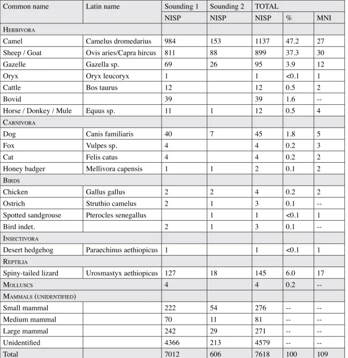
The faunal remains
The zooarchaeological study is important not only for understanding the environment of al-Yamāma oasis but also to understand the subsistence strategies of the site’s inhabitants and the sources of their food. In the long-term,
it also aims at a better understanding of the development dynamics of the management and exploitation of animal resources during each phase of occupation in the different areas of the settlement and then an evaluation of the main diachronic changes registered.
Present species
The total bone assemblage at al-Yamāma comprises 7728 faunal remains, with a total weight of nearly 78.4 kg. The fauna list presented in table 2 summarizes the various species on the basis of the number
Common name Latin name Sounding 1 Sounding 2 TOTAL
NISP NISP NISP % MNI
herbivora
Camel Camelus dromedarius 984 153 1137 47.2 27 Sheep / Goat Ovis aries/Capra hircus 811 88 899 37.3 30
Gazelle Gazella sp. 69 26 95 3.9 12
Oryx Oryx leucoryx 1 1 <0.1 1
Cattle Bos taurus 12 12 0.5 2
Bovid 39 39 1.6
--Horse / Donkey / Mule Equus sp. 11 1 12 0.5 4 carnivora
Dog Canis familiaris 40 7 45 1.8 5
Fox Vulpes sp. 4 4 0.2 3
Cat Felis catus 4 4 0.2 2
Honey badger Mellivora capensis 1 1 2 0.1 2
birdS
Chicken Gallus gallus 2 2 4 0.2 2
Ostrich Struthio camelus 2 1 3 0.1
--Spotted sandgrouse Pterocles senegallus 1 1 <0.1 1
Bird indet. 2 1 3 0.1
--inSectivora
Desert hedgehog Paraechinus aethiopicus 1 1 <0.1 1 rePtilia
Spiny-tailed lizard Urosmastyx aethiopicus 127 18 145 6.0 17
molluScS 4 4 0.2 --mammalS (unidentiFied) Small mammal 222 54 276 -- --Medium mammal 70 11 81 -- --Large mammal 242 29 271 -- --Unidentified 4366 213 4579 -- --Total 7012 606 7618 100 109
Table 2. Species list from the 2011–2012 excavations at al-Yamāma (NISP: Number of identified specimens; % NISP: only for the identifiable element; MNI: minimum number of individuals).