Publisher’s version / Version de l'éditeur:
Canadian Journal of Civil Engineering, 17, 5, pp. 798-812, 1990-10
READ THESE TERMS AND CONDITIONS CAREFULLY BEFORE USING THIS WEBSITE. https://nrc-publications.canada.ca/eng/copyright
Vous avez des questions? Nous pouvons vous aider. Pour communiquer directement avec un auteur, consultez la première page de la revue dans laquelle son article a été publié afin de trouver ses coordonnées. Si vous n’arrivez pas à les repérer, communiquez avec nous à PublicationsArchive-ArchivesPublications@nrc-cnrc.gc.ca.
Questions? Contact the NRC Publications Archive team at
PublicationsArchive-ArchivesPublications@nrc-cnrc.gc.ca. If you wish to email the authors directly, please see the first page of the publication for their contact information.
NRC Publications Archive
Archives des publications du CNRC
This publication could be one of several versions: author’s original, accepted manuscript or the publisher’s version. / La version de cette publication peut être l’une des suivantes : la version prépublication de l’auteur, la version acceptée du manuscrit ou la version de l’éditeur.
Access and use of this website and the material on it are subject to the Terms and Conditions set forth at
The San Francisco area earthquake of 1989 and implications for the
greater Vancouver area
Rainer, J. H.; Jablonski, A. M.; Law, K. T.; Allen, D. E.
https://publications-cnrc.canada.ca/fra/droits
L’accès à ce site Web et l’utilisation de son contenu sont assujettis aux conditions présentées dans le site
LISEZ CES CONDITIONS ATTENTIVEMENT AVANT D’UTILISER CE SITE WEB.
NRC Publications Record / Notice d'Archives des publications de CNRC:
https://nrc-publications.canada.ca/eng/view/object/?id=a8a3dc67-e5d6-4361-9d13-85ce8274f7cb https://publications-cnrc.canada.ca/fra/voir/objet/?id=a8a3dc67-e5d6-4361-9d13-85ce8274f7cbSer
National Research
Conseil national
TH1
*I
Council Canada
de recherches Canada
N21 d
no,
1675
c. 2 BLDGInstitute for
lnstitut de
Research in
recherche en
Construction
construction
The San Fmncisco Area Earthquake of
1989
and
implications
for the Greater Vancouver Area
by J.H. Rainer, A.M. Jablonski, K.T.
Law, and D.E. Allen
Reprinted from
Canadian Journal of Civil Engineering
Vol. 17, No. 5
October 1990
p. 798-81
2
(IRC Paper No. 1675)
NRCC
32343
A N A L Y Z E D NRC-
cisnL I B R A R Y
I
B I B L I O T H ~ Q U E
I R C
CNRC-
ICISTThe San Francisco area earthquake of
1989
and implications for the
Greater Vancouver areal
J. H. RAINER, A. M. JABLONSKI, K. T. LAW, AND D. E. ALLEN
Institute for Research in Construction, National Research Council of Canada, Ottawa, Ont., Canada KIA OR6
Received March 12, 1990
Revised manuscript accepted May 25, 1990
.The earthquake that hit the San Francisco area on October 17, 1989, is reviewed with respect to damage to buildings, trans- portation facilities, and services. The San Francisco experience underlines that soil conditions and inadequate structural integrity are the two most important factors in the seismic risk to a building and its inhabitants. This earthquake is used as a model for the damage prediction in the Greater Vancouver area from a "design earthquake" that is implied in the National Building Code of Canada. In comparable housing density the expected damage would be somewhat greater than that observed in the San Francisco region in October 1989 because of differences in amplitude of ground motions and building design standards. This study is seen as a first step in the detailed assessment of damage potentials for the Vancouver region, or other similar metropolitan areas. Potential shortcomings in the 1985 National Building Code of Canada were identified in the seis- mic requirements for non-engineered buildings (Part 9) concerning lateral bracing, beam splice ties over supports, and anchorage and reinforcing of chimneys.
Key words: earthquake damage, building code, damage prediction.
Les auteurs Ctudient les dommages causCs aux immeubles, aux Cquipements de transport et aux services par le sCisme qui a frappC la rCgion de San Francisco le 17 octobre 1989. Cet tvCnement montre que les conditions du sol et le dCfaut d'intCgritC des constructions sont les deux plus importants facteurs de risque sismique pour un irnrneuble et ses occupants. Les auteurs se servent de ce sCisme c o m e modele pour prCvoir les dommages que causerait dans la rCgion du Grand Vancouver un &isme de calcub c o m e celui qui est utiliqt dans le Code national du bltiment du Canada. Dans une region
a
densit6 de population comparable, les dommages seraient 1Cgerement plus skrieux que ceux observCs en octobre 1989 dans la rkgion de San Francisco en raison des diffkrences aux niveaux de l'amplitude des mouvements du sol et des normes de construction des bltiments. Cette Ctude constitue la premiere Ctape d'une tvaluation dCtaillCe des risques de dommages pour la rCgion de Vancouver ou une autre rCgion mktropolitaine semblable. On a relev6 des lacunes possibles du Code national du bltiment du Canada 1985 au plan des exigences sismiques visant les bltiments non techniques (partie 9), plus prCcisCment en ce qui a trait L l'entretoisement, aux plaques d'attache des poutres, vis-a-vis des supports, ainsi qu'i l'ancrage et au renforcementdes cheminks.
Mots clds : dommages causes par les skismes, code du bltiment, prevision des dommages.
[Traduit par la revue]
Can. 1. Civ. Eng. 17, 798-812 (1990)
Introduction
On October 17, 1989, at 17:04 Pacific Daylight Time, a strong earthquake, called Loma Prieta, shook the entire San Francisco Bay area. Eight days after the earthquake, a team from the National Research Council of Canada consisting of two of the authors (Law and Jablonski) and three other partici- pants visited the area. The prime obj,ective was to determine the nature and extent of the damage to buildings and lifelines in the San Francisco Bay area with a view to predicting the expected impact of a similar magnitude earthquake in the Greater Vancouver area.
Such predictions should be of interest to emergency plan- ners, community leaders, the design professions, and the popu- lation at large. Predictions are needed for making informed decisions on allocation of resources for preparedness, retro- fitting of buildings and facilities, and for countering possible economic consequences of a destructive event. This study deals with the broad picture of the earthquake effects and is seen as a first step in the direction of detailed damage assess- NOTE: Written discussion of this paper is welcomed and will be received by the Editor until February 28, 1991 (address inside front cover).
'NRC No. 32343.
Printed in Canada 1 Imprime au Canada
ments for other locations; we hope further refinements will be made in the years to come.
Synopsis of Lorna Prieta earthquake
The Loma Prieta earthquake of Richter magnitude ML = 7.0 was caused by the rupture of a section of the San Andreas Fault with the epicentre located approximately 16 km north- east of the city of Santa Cruz (Fig. 1). Surface wave magni- tude was calculated as M, = 7.1 (USGS 1989). Within a period of 12 days after the main shock, 80 aftershocks of mag- nitude 3.0 and larger were recorded, the largest one being magnitude 5.2.
This was the largest magnitude earthquake in northern California since the San Francisco earthquake of April 18, 1906, of magnitude 8.3. The Loma Prieta earthquake has been estimated as one of the largest natural disasters in U.S. his- tory, with $10 billion economic losses, 64 confirmed deaths, and more than 3700 injuries. It caused severe damage to a number of engineered structures: collapsed the Cypress Street viaduct of the interstate highway 1-880 (also called Nimitz Freeway), where dozens of motorists were killed; collapsed the section of the San Francisco-Oakland Bay Bridge on the Oakland side of the bridge where the earthquake caused dis- placement of 18 cm; and heavily damaged a number of bridges
RAINER ET AL. 799
FIG. 1. The geographical areas affected by the Lorna Prieta earthquake.
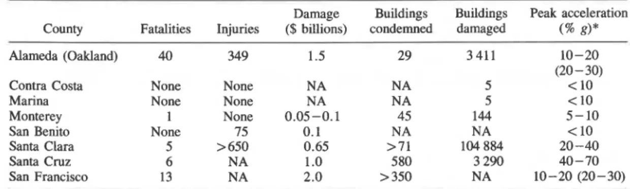
and' highways. A number of cities were hit, including San the San Francisco region is shown in Table 1 (expanded from Francisco and Oakland, but the major areas of destruction Astaneh et al. 1989), along with the prevalent level of ground were limited to several pockets associated with soft soil acceleration in the major built-up areas. The county bound- deposits, especially fill areas. The earthquake caused ground aries are shown in Fig. 1. The number of buildings imrnedi- failures in many areas, including soil liquefaction, landslides, ately condemned is seen to be around 500 outside of the soil lateral spreads, and ground cracks. epicentral area, Santa Cruz County.
800 CAN. J . CN. ENG. VOL. 17, 1990
TABLE 1. Preliminary data on damage distribution (from Astaneh et al. 1989 and updated from county sources)
County Fatalities Alameda (Oakland) 40 Contra Costa None
Marina None
Monterey 1
San Benito None Santa Clara 5 Santa Cruz 6 San Francisco 13 Injuries 349 None None None 75 > 650 NA N A Damage
($ billions) condemned Buildings Buildings damaged Peak acceleration (% g)*
NOTE: NA = not available.
*Dominant level in major population centres on rock or alluvium. Values in parentheses are accelerations on soft ground I and fill.
tinence to Canadian engineering practice has been presented moisture content normally exceeding 50%, and may be as by Bruneau (1990). thick as 40 m. Shear wave velocities in this deposit range from
Strong-motion seismograph data
The Loma Prieta earthquake triggered over 100 strong- motion seismographic stations in the San Francisco Bay area. A preliminary summary of the strong-motion measurements is given by Maley et al. (1989), CSMIP (1989), and Shakal et al. (1989).
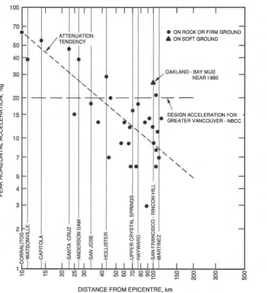
Figure 2 presents the peak horizontal accelerations vs. epicentral distance for a partial set of the recorded ground motions on rock or firm ground. The attenuation tendency is also indicated. High peak accelerations were recorded near the epicentre, at larger distances in Oakland near 1-880, and at the Presidio (U.S. Army Base) in San Francisco, close to the heavily damaged area in the Marina District. A contour map based on the peak accelerations recorded on rock and alluvium is presented in Fig. 3, which shows that the peak ground accelerations attenuated rapidly in directions normal to the San Andreas Fault, but propagated with much less attenuation parallel to the fault. This could be due to different geological features such as the presence of numerous fault lines that parallel the San Andreas Fault, as well as source characteris- tics of the earthquake. This is also an explanation for the rela- tively large scatter of accelerations shown in Fig. 2, and indicates that a single attenuation rate is not always adequate for characterizing the seismological aspects of a site.
Effects of ground conditions
Widespread earthquake damage to structures and buildings is generally a direct result of the intensity and type of ground shaking. Local ground conditions can change the characteris- tics of earthquake motions that exist at the bedrock. In par- ticular, thick deposits of compressible soils can raise the intensity of motions in a certain frequency range, leading to severe damage to buildings. Such deposits are abundant in the San Francisco Bay region and exist in three different types: fills, Bay mud, and alluvium.
Fills are man-made deposits normally loose in nature and much thinner than the natural deposits of Bay mud and allu- vium. For example, in the Marina District, centrally located on the northern coast of the City of San Francisco, the fills were placed hydraulically. They are of very loose, uniform sand with sea shells. The Bay mud consists mostly of recent deposits (8 000 years and younger) of soft plastic carbonace- ous clay, silt, and minor sand inclusions. It is loose, with
90 to 130 m/s. The alluvium, with thickness reaching600 m, corresponds to an older Bay sediment. It consists mostly of silty clay, silty clayey sand, sand, and gravel, It generally has a moisture content of less than 40%. The shear wave velocities in this deposit increase with depth and at the surface the value is about 200 m/s. The characteristics and distribution of Bay mud and alluvium are given by Borcherdt et al. (1975).
During the 1989 Loma Prieta earthquake these deposits responded in three ways, causing serious damage or collapse of structures and buildings: amplification of ground motions, liquefaction failure, and other ground problems such as settlement.
AmpliJication of motions
The amplification of earthquake motions depends on soil properties, thickness, frequency content of motions and local geological settings. For a given earthquake and geological setting, the amplification increases with increase of soil com- pressibility and with increase of soil thickness. The amplifica- tions in the Bay mud are estimated to have been 2 - 3 times the bedrock values.
Thus, structures founded on these compressible deposits have been subject to high horizontal excitation during the earthquake.
AU
the major damages in the City of San Fran- cisco and a majority in Oakland occurred on these deposits.-
Many residential houses in the Marina District sustained severe damage and some even collapsed, a major factor being the high amplification due to the Bay mud and the hydraulic-
fill. Houses similar to the collapsed ones just outside the Marina District exhibited significantly less damage. The pier supporting the collapsed section of the Bay Bridge was founded on the Bay mud. Also, the collapsed Cypress section of the Nimitz Freeqay was built on compressible soil, while the noncollapsed section was founded on alluvium. This sug- gests that Bay mud yields a higher amplification than the allu- vium. On the other hand, a number of multistorey steel frame buildings and reinforced concrete buildings in downtown Oak- land suffered structural damage where alluvium prevails. Strong-motion records on alluvium also indicate amplifica- tions compared to bedrock. In downtown Santa Cruz, where land was reclaimed with man-made fills, 85% of the unrein- forced masonry buildings were damaged, although in this epicentral area the intensity of shaking was also substantially larger (Fig. 3).RAINER ET AL. 80 1
FIG. 2. Measured peak horizontal accelerations on rock or alluvium vs. epicentral distance, Lorna Prieta earthquake (Data from Maley et al.
1989; CSMIT 1989; Shakal et al. 1989).
Liquefaction
Liquefaction is a process in which soft saturated granular soil is transformed to a liquid as a result of earthquake shaking or by other dynamic disturbance. When this happens the soil beneath the surface loses strength and, under pressure from
-
the overburden, tends to eject the water and soil mixture through the ground surface. This will result in cracking of ground, ground heave, sand boils, and differential settlement. All these-
phenomena were observed over an extensive area rangingfrom very near the epicentre to more than 100 km away.
I
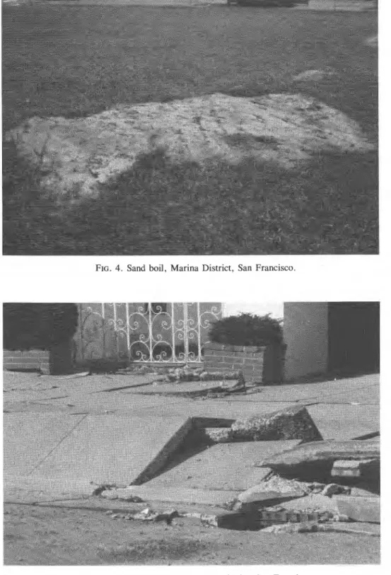
In the Marina District, liquefaction failure was widespread. More than 20 sand boils were noted by the visiting tea&(e.g., Fig. 4). Differential settlement, bearing capacity failure, pave- ment damage, and buckled sidewalks were observed (Fig. 5).
Buried utilities, including gas lines, were broken and led to spectacular fires. The material that flowed to the surface was a dark grey uniform sand with occasional sea shells, indicating that the hydraulic fill placed on site liquefied during the earthquake.
Other ground problems
Loose granular de~osit. both saturated or unsaturated. mav
Here fills were placed on top of Bay mud. The structure of the freeway was damaged to the point of near collapse. The foot- ings for the structures and nearby buildings founded on pile- foundations suffered from different degrees of permanent settlement. The paved ground surface at one location settled 15 cm because of densification of the fill. Subsidence was also observed at a number of bridge approaches.
A large number of landslides and rockfalls were reported in the Santa Cruz mountains near the fault rupture zone. Many of these landslides were partly caused by rain that came after the earthquake. Highway 17, one of the two main highways into Santa Cruz from the north, was closed. A number of single-family houses were destroyed.
Signs of distress in a number of dams were reported. The Lexington earth dam suffered from some cracks, as did about 1.5 km of the San Lorenzo levee in Santa Cruz. The abutment of the Elsman dam sustained some cracks. Another 1.5 km levee along the Pajaro River outside Watsonville was damaged with evidence of liquefaction failure.
Performance of buildings
densify, reading to ionsi'derable settlement even without t& The Loma Prieta earthquake provided an opportunity to test phenomenon of liquefaction. An example is found at Embar- various types of building structures, from single-family dwell- cadero Freeway on the northeastern coast of San Francisco. ing houses and medium size buildings in the Santa Cruz area
802 CAN. J. CIV. ENG. VOL. 17, 1990
F I G . 3. Contours of peak ground accelerations recorded on rock or alluvium, Lorna Prieta earthquake (Data from USGS 1989).
to high-rise buildings in San Francisco and Oakland. Struc- tural damage was concentrated in pockets and depended on a number of factors, including type of the structure, year of con- struction, lateral resistance, and local ground effects. After- shocks have augmented damage in several buildings. A brief description of representative damage patterns is presented. Wood fiame housing
Two types of wood frame houses sustained heavy damage: single-family dwellings in the epicentral area (about 50 km radius) and old wood frame apartments and townhouses in the Marina District in San Francisco (about 100 km from the epicentre).
In the epicentral area (e.g., in Watsonville and in Los Gatos) "cripple" stud foundation walls (or "pony" walls) failed in many old wood frame houses, causing serious damage. Cripple stud walls form the connections between foundations (concrete or masonry) and the first-floor framing. They are usually short, but in some modern wooden houses could reach a height of close to one full storey. Improper bracing and
inadequate connections to the foundations as well as to the . first-floor framing caused older buildings to be moved later- ally off their foundations. The cripple walls were in some cases laying flat on their side (Fig. 6) where the acceleration reached 0.40g for about 16 s. Nailing on some failed walls was
sparser than required by the building code. Also, large open- , ings (e.g., porches) collapsed owing to lack of lateral resis-
tance and settlement of the foundations.
The majority of modern wooden houses performed well unless they were situated on ground fissures. However, some houses with large openings like garage doors or with other irregularities sustained substantial damage in Los Altos Hills near Palo Alto, about 50 krn from the epicentre, where the acceleration reached about 0.38g. In general, poor connec- tions or lack of structural continuity in the design were the prime reasons of damage in wood frame houses.
The area of greatest damage outside the epicentral region was concentrated in the Marina District in San Francisco situ- ated on the fill placed after the 1906 earthquake. The highest acceleration on the nearest firm ground, 0.21g, was recorded
RAINER ET AL. 803
FIG. 4. Sand boil, Marina District, San Francisco.
FIG. 5. Buckled pavement, Marina District, San Francisco. in the Presidio (U.S. Army Base), a few blocks northwest
from the Marina District and 105 krn from the epicentre. The
wood frame houses, constructed in the early 1920s, consist of two main types: two- and three-storey townhouses with garages on the street level, and three- and four-storey apart- ment buildings also with street-level garages. There is almost no separation between buildings. Many older three- and four- storey apartment houses situated at the street corners were
badly damaged (Fig. 7). Some spectacular collapses of the
entire building occurred when the one or two storeys were
completely leveled. The garage floors had acted as a "soft storey" that appeared to have only limited bracing or none at all, or had sheathed walls constructed with boards nailed to posts. External stucco, brick, or fake stone walls were severely damaged and some collapsed. Many two-storey townhouses within the blocks also sustained some damage over garage doors and in walls. Entire blocks of buildings apparently responded together during the earthquake.
For some buildings where more horizontal resistance is provided by sheathed walls, the damage was much smaller. In
804 CAN. J. CIV. ENG. VOL. 17. 1990
FIG. 6. Collapsed cripple wall and porch in a residence at Main Street in Los Gatos.
tri
TI
7FIG. 7. Near collapse of a four-storey wood frame apartment building at the comer of Beach and Broderick streets, Marina District, San Francisco.
general, upper floors sustained little or no structural damage, although the entire ground floor of the building may have shifted. In other locations, houses at the interior of the block suffered less damage than those at the end of the block.
Unreinforced masonry buildings
Unreinforced masonry buildings near the epicentre built at the turn of this century suffered severe damage or collapsed (Figs. 8 and 9). Out-of-plane failures of upper portions of
walls and of parapets were common. In some cases the severe shaking at the roof level resulted in separation of the roof from the walls. The result was not only the collapse of upper portions of walls but also of the roof structure, and this inflicted heavy damage to lower floors. Other old unreinforced masonry buildings in Oakland were heavily damaged.
Upgraded unreinforced brick masonry buildings performed well. Upgraded stone masonry buildings at Stanford Univer- sity in Palo Alto also performed well, in contrast to unrein-
RAINER ET AL. 805
apsed roof caused damage to the lower floors in the unreinforced masonry building on Campbell St1 reet in Oakland.
FIG. 9. Major damage to unreinforced masonry wall building, 39 Main Street, Los Gatos. forced masonry and old-style reinforced concrete buildings
that suffered damage estimated at over $100 million; substan- tial structural damage was sustained by the masonry walls of the chapel.
Engineered buildings
The high-rise buildings in downtown San Francisco and Oakland rode out the earthquake without serious damage to the structural frame or the functionality of the buildings. But prob- lems were encountered with elevators and with breakage of
glass panes that showered debris onto the street. The pyramid- shaped Transamerica Building in downtown San Francisco received ground motions of 0.1 lg, whereas the 49th floor near the apex recorded 0.31g. It should be noted, however, that the ground motion experienced by the buildings in downtown San Francisco is about one half to one quarter those of the "design earthquake" for that location. Consequently, they were not tested to the full extent of their intended capacity.
Closer to the epicentre, the Palo Alto VA Hospital Building 1 was subjected to 0.34g at the base, and responded with 1.09g
806 CAN. J. CIV. EN( 2. VOL. 17, 1990 at the 7th floor below the roof. The highest recorded horizon-
tal acceleration in a building was in the four-storey Govern- ment Building in Watsonville, in which 0.39g was recorded at the base and 1.24g at the top storey (Shakal et al. 1989). Both these buildings suffered little damage.
Performance of services Transportation structures
In addition to the collapse of more than 1.5 km of elevated roadway of 1-880, and collapse of a 16 m span on the upper deck of the San Francisco-Oakland Bay Bridge, 13 of the 1 500 highway bridges in the area suffered major structural damage; 73 others suffered less severe damage (ASCE News
1989).
Damage to the control tower at the San Francisco inter- national airport closed the facility for 13 h, and liquefaction and settling also forced a runway closing at the Oakland air- port. The tunnels and tracks of the BART (Bay Area Rapid Transit) system, however, performed well with only short temporary disruptions of service.
Water and sewage
There was extensive damage to water lines from ground deformations. In San Francisco, 72 significant pipe failures occurred in the Marina District and 25 breaks outside that area. A break in a 30-cm (12-in.) high-pressure line south of Market Street, where there was significant liquefaction, caused depletion of a 3 410 000-L (750 000-gallon) tank used for fire fighting. Hollister reported over 100 broken water mains and Santa Cruz, over 60. Large water mains failed in Santa Clara County, Los Gatos, and in the East Bay Municipal District; the latter reported over 140 additional broken mains (ASCE News 1989).
Assessment of damage to sewage collection systems is more difficult, since they generally do not operate under pressure and will continue to operate even if leaks are present. Typi- cally, however, sewage systems are more vulnerable to seis- mically induced differential soil movements than water systems because the former are made of more brittle materials. Gas and power
Only three failures of gas lines were reported: leaks in a 51-cm (20-in.) semi-high-pressure welded steel distribution line in Oakland, a 30-cm (12-in.) line in Hollister, and a 20-cm (8-in.) line in Santa Cruz (ASCE News 1989). In the Marina District, about 16 km of gas lines will need to be replaced at an estimated cost of $20 million. These gas lines were made of cast iron. New lines were being installed in the same area using flexible plastic pipes according to ASTM 25 13 specifica- tions. Automatic shutoff valves for gas supply exist in Cali- fornia but they are generally unpopular, since they are prone to accidental closure and can be turned on only by qualified personnel. This has sometimes taken weeks during previous drills or small earthquakes.
Initial electric power outages affected about 1.4 million cus- tomers. Within 48 h, though, service to all but 26 000 of those had been restored. The most severe damage occurred to sub- stations, primarily to ceramic members of circuit breakers and oil leaks to transformers. Major damage occurred at two key substations in San Jose and San Mateo, the 500-kV switch- yards at the Metcalf substation and the 500-kV switchyard at Moss Landing. At least one distribution station in the epi- central area also had its transformers damaged (ASCE News 1989).
Communications
As in most earthquakes, an increase in telephone traffic in the hours immediately after the event overloaded the system so that there were long delays in getting dial tones on non- priority lines. Calls could be made within the same area code in most areas, however, if they were dialed several times. Radio announcements right after the earthquake requested that only emergency calls be made and this probably contributed to the system's overall good performance.
The use of cellular phones was singled out as the best per- former at the control centres located in specific disaster areas. CB radios were completely jammed because of the over- whelming usage after the earthquake. Other telephone lines were in operation except those that went through sophisticated
private switching units. Some of these units failed because of a
the power outage; apparently their standby power supply had not been maintained.
Elevators
California has a special elevator code for use in tall build- ings in earthquake zones. The performance of many elevators built according to this code, however, was not up to expecta- tion. The most common problem was that the counter weight jumped off the guide rail, rendering the elevator unusable. It appears that the code needs revising.
Emergency preparedness
California has made extensive preparations for the effects of earthquakes. Most California cities have annual drills for earthquake emergency. The drills are costly and inconvenient but they demonstrated their value in dealing with this disaster. Shortly after the earthquake, control centres were set up at the major disaster areas and were staffed by police, firefighters, rescue workers, building inspectors, and authorized volun- teers. As one example, and as part of the emergency plan, volunteers from as far as Los Angeles were on their way to the San Francisco Bay area within minutes after the earthquake. In the epicentral area, tent shelters were erected in public parks and food was provided by the American Red Cross. Structural engineers who had previously been trained in earth- quake damage assessment categorized buildings into three groups: safe (designated by green posters), unsafe (red posters), and limited access (orange posters). Access was completely denied to "unsafe" buildings; entry into buildings declared "limited access" was permitted under supervision and for short periods only.
Basis for applying San Francisco experience to Vancouver
To estimate damage predictions for Vancouver on the basis of the experience with the Loma Prieta earthquake (and other similar earthquakes) requires consideration of the following factors:
earthquake characteristics (magnitude, depth and type of rupture, duration, frequency content);
location of earthquake, distance and direction from
epicentre;
geology and soil conditions; codes and standards; type of construction; and
level of earthquake resistant design in use when buildings were constructed.
Damage addressed here is of a level that would prevent safe occupancy of the building immediately after the earthquake.
RAINER ET AL. 807
This can vary from repairable damage to total collapse. In the soil deposit. On the other hand, the dynamic strength is a func- context of the California earthquake preparedness plan, this tion of the soil type and duration of shaking. There are a num- would include buildings tagged with "orange" and "red" ber of methods of expressing the dynamic stress and the posters in the post-disaster assessment. dynamic strength. The method presented by Seed et al. (1983) cbntains the essential concepts and has been widely used.
Earthquake characteristics
The magnitude 7.1 Loma Prieta earthquake generated Based on this method, the dynamic stress, rh, is given by ground motions consisting of relatively low frequencies [I]
T~ = 0.65amaxavrd (judged to be mainly between 1 and 3 Hz horizontally, and 2 g and 6 Hz vertically)-and duration of shaking of about f0 - 15 s.
These are typical values for moderate earthquakes that occur on the west coast of California. By reasonable extrapolation, a similar type of earthquake can be expected for Vancouver, at an epicentre within 50-80 km of the city and produce a
'
.
ground acceleration in the Vancouver area that corresponds tothe 0.20g design acceleration of the National Building Code. Earthquakes with a magnitude 6 at epicentres of 30-50 km from the city would have similar effects, but the duration
1
might be somewhat less. On the other hand, earthquakes larger than magnitude 7.0 at distances of 150 -200 km could be expected to produce similar ground motion amplitudes but with longer duration. Duration is an important parameter as it pertains to severity of damage. Thus for comparison purposes, an earthquake of similar magnitude and distance from the epicentre is the most suitable one for estimating damage in Vancouver. Not considered here is the possibility of the "sub- duction earthquake," with possible magnitudes up to 9.3 and duration of minutes (Rogers 1988).
Frequency content is a function of the rupture mechanism, earthquake magnitude, distance, and geologic features in the affected area. It can reasonably be assumed that frequency content in a future earthquake near Vancouver is not signifi- cantly different from that of the San Francisco area ground motion.
Soil conditions in the Greater Vancouver area
The geology of the Greater Vancouver area is described by Blunden (1973) and by Byrne and Anderson (1987). The area is underlain by thick clays, followed by sands, silt-clay deposits on the bedrock, or bedrock itself in some areas north of the Fraser River. There is a certain variability in soil condi- tions between the Fraser Delta and Burnaby Ridge in the north -south direction and also between the Fraser Delta and the eastern part of Surrey.
Typically, the Fraser Delta deposits have the following layers: (1) a surficial deposit comprised of thin layers of clays, silts, and peats (max. thickness of 8 m); (2) sand deposits (about 45 m); (3) silt-clay deposits (about 200 m); (4) glacial deposits (about 100 m); and (5) bedrock. The water table in the lower areas is generally within a metre of the ground surface.
The western portion of the Greater Vancouver area, except the central hilly part of the municipality of Surrey, is generally underlain by silty -clay deposits, while there are peat deposits in the eastern portion. The liquefaction threat is mainly for thick layers of sand deposits underlying thin crust of clays or silts. The dynamic liquefaction resistance of these sands can be estimated from their standard penetration resistance value, N, as will be discussed later.
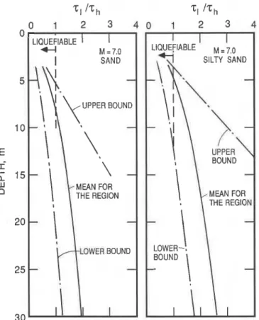
Conditions for liquefaction
Liquefaction will occur when the induced dynamic stress exceeds the dynamic strength of the soil. The dynamic stress is a function of the earthquake magnitude and epicentral dis- tance as well as the geometry and mechanical properties of the
where a,,, = peak horizontal acceleration at ground surface, g = gravitational acceleration, a, = total vertical stress, and
r, = a reduction factor varying with depth. The value of a,, depends on a number of factors including the spectrum of earthquake waves, attenuation property of the bedrock, and the amplification due to the soil deposit. The dynamic strength, rl, was established by Seed et al. (1983) based on observations of actual earthquakes around the world. It is expressed in terms of normalized standard penetration test (SPT) resistance, N,, and a coefficient, p , related to earth- quake magnitude. A general form of the expression is given by
where f(Nl), a function of Nl, is different for sand and for silty sand. Liquefaction will take place when the dynamic stress, 71, exceeds the dynamic strength, rh:
Liquefaction potential
Liquefaction potentials were assessed for the deposits in the Fraser River delta. There are other soft deposits in the area, however, and the same analysis as presented here should not be assumed to apply unless specifically checked. The present analysis is based on the design earthquake according to the National Building Code of Canada 1985 (NBCC 1985), with a return period of 475 years and a peak bedrock acceleration,
a,, of 0.20g. The corresponding design earthquake magni- tude, M, as suggested by Byrne and Anderson (1987) is taken as 7.0.
The induced dynamic stress, rh, depends on the maximum ground surface peak acceleration, a,,, which is a function of the bedrock acceleration, a,. A study by Byrne and Anderson (1987) on typical soil profiles from Richmond shows that either slight amplification or slight deamplification is possible when the seismic waves travel from bedrock through the soil to the ground surface. It is assumed, therefore, that there is no change in amplitude of the acceleration from bedrock to the ground surface, i.e., a,,, = a,. The validity of this assump- tion, however, would need to be confirmed by measurements of seismic response at the surface and on nearby rock or at great depth.
The dynamic strength of the alluvial deposit can be obtained from the standard penetration test (SPT). Figure 10 shows pro- files of regular SPT resistance, N, at various sites in Richmond and the Fraser Delta (Byrne and Anderson 1987). N can be normalized by the confining pressure to yield Nl for applica- tion in [2]. Some soil variability can be clearly identified and, therefore, in order to assess the dynamic strength accurately, each site has to be studied separately. It is, however, revealing to consider some typical profiles to give a broad picture of the liquefaction potential for this region. Three profiles are chosen for this purpose: the mean, the lower bound, and the upper bound (Fig. 10). The mean corresponds to the average of all
808 C A N . J . C I V . E N G . VOL. 17, 1990 THE REGION LOWER BOUND
-
Annacis Island BOUND 0 10 2 0 30 40 50STANDARD PENETRATION RESISTANCE, N
FIG. 10. Mean standard penetration resistance values, N, and derived bounds in Richmond, B.C., and Fraser Delta (Data from Byrne and Anderson 1987).
the profiles while the lower and upper bounds correspond to the weakest and strongest profiles. From these profiles, the dynamic strengths are obtained using [2]. Since both sand and silty sand exist in this region, strength profiles for both soil types have been obtained.
The liquefaction potential of the deposits from the Fraser Delta can now be studied by comparing the dynamic strength, 71, and dynamic stress, rh. The results are shown in Fig. 1 1 , which show that for the design earthquake, sand and silty sand with average strengths are expected to liquefy to depths of 8 and 5 m, respectively.
Codes and standards
Two major types of construction can be recognized: (i) engi- neered construction and (ii) residential "non-engineered" construction. For purposes of comparisons, the 1985 versions of the National Building Code of Canada (NBC) and the Uni- form Building Code (UBC) will be used. These codes provide the basis for applicable regulations in Vancouver and San Francisco area, respectively.
Engineered buildings (Part 4 of NBC)
Engineered construction follows applicable building codes as a minimum, but these standards are often exceeded for spe- cial structures such as some tall buildings. Most buildings in the San Francisco area would be designed to a zone 4 require- ment in the UBC. In the Vancouver area the NBC require- ments correspond to those of a velocity and acceleration zone Z, = Z, = 4 (no relation to the UBC zone 4) with v = 0.20.
Comparable types of buildings and therefore comparable coefficients in the specified lateral forces are used for this comparison. On soft soil deposits, a foundation factor up to
1.5 is applicable, but the comparison presented here will be made for "rock or firm ground."
For the San Francisco area, the 1985 UBC design base shear for low-level buildings results in a base shear, V, of 0.12W, where W = weight of building. For a comparable building in Vancouver, the 1985 NBC prescribes a base shear, V, of
0.088W. For tall buildings (example period, T = 2 s),
VUBC = 0.047 W and VNBC = 0.03 1 W. Since both codes uti- lize a load factor of about 1.5, it can be seen that the ratio of
RAINER ET AL. 809 UPPERBOUND 5 MEAN FOR THE REGION I I LIQUEFIABLE
I
=S,O
1
I BOUND THE REGION-
BOUND-
LOWER-.I
-
-
I IFIG. 1 1. Derived liquefaction potential of alluvial deposits in Fraser Delta during a design earthquake with ,,a, = 0.2g and M = 7.
design forces for Vancouver to those of San Francisco is about 213. Thus the design forces in NBC 1985 for Vancouver would correspond to slightly less than a zone 3 requirement in the UBC, which in turn is 314 that of San Francisco. It should be pointed out that neither the NBC nor the UBC addresses the problems of liquefaction directly, but both codes consider it an area deserving special attention. The topic is, however, treated in the Canadian Foundation Engineering Manual (CGS 1985). Non-engineered buildings (Part 9 of NBC)
Non-engineered buildings (also called "residential con-
*
struction") include single-family houses and multi-unit dwell- ings up to and including three storeys in height or 600 m2 of floor area.
L
Table 2 compares the requirements for residential construc- tion governed by Part, 9 of the NBC with the UBC. The requirements are similar except that some earthquake require- ments in the UBC are missing from the NBC. Where require- ments exist in both codes, they are essentially the same. The experience of the Loma Prieta earthquake indicates that the most serious deficiency in Part 9 of the NBC is the lack of any requirements for wall bracing in wood frame construction. Ground floors of two- or three-storey residential buildings containing large openings are vulnerable.
Other potential deficiencies in Part 9 of the NBC include the need for tieing ends of beams over supports and anchorage of masonry chimneys to the roof and floors. Collapses due to these deficiencies have occurred in this and previous earth- quakes. Lateral collapse of foundation walls weak in racking resistance (such as cripple-stud walls) was also a serious
failure mode near the epicentre. This is covered by the NBC Part 4 lateral force requirements via Clauses 9.15.1.5 (wood frame foundations) and 9.4.1.1 (construction not specified in Part 9). Many designers or builders, however, may not be aware of this.
Nearly all the serious structural failures that occurred to residential construction in the San Francisco area were due to deficiencies that are prohibited by the recent issues of the UBC. Although the earthquake intensity was less than the design earthquake except near the epicentre, the experience indicates that the present UBC requirements appear satis- factory. An exception to this is that the veneer anchor ties failed. Since these are specified in 3006(d)l of the UBC and since Part 9 of NBC has a similar requirement, the detailed reasons for the failures should be investigated.
The main problem in Canada, as in other places, concerns the safety of existing buildings with serious deficiencies, such as unreinforced masonry, non-ductile concrete, and wood frame complexes with weak ground storeys. The seismic evaluation and upgrading of existing construction therefore requires attention.
Level of earthquake resistant design
For engineered construction, the level of earthquake resis- tant design that was employed when the buildings were con- structed also plays a role in comparing damage potential. As was pointed out above, the seismic requirements for engi- neered construction are lower in Vancouver than in San Fran- cisco. Therefore the same earthquake would be expected to produce more damage in the ~ r e a t e r Vancouver area.
For non-engineered construction, nominal lateral resistance in the UBC is achieved by specifying minimum percentages of shear panels in the walls. Since no such requirement is con- tained in the NBC, Part 9, it can be concluded that the lateral resistance of houses with weak configurations (e.g., large openings) in Vancouver is likely to be less than in the San Francisco area, thus making these buildings more vulnerable to comparable size earthquakes. The level of awareness among builders of potential earthquake hazard is also likely to be somewhat higher in California than in Canada, again pointing to a possible lower level of overall seismic resistance for houses on the British Columbia coast. The lateral resistance in most wood houses is inherently quite high, however, and therefore the overall reduction in seismic resistance should be marginal.
Damage assessment for the Vancouver area
Extension of the San Francisco area earthquake to ground motions that correspond to the design earthquake for Van- couver requires a number of assumptions and extrapolations. As a rough approximation, the peak ground accelerations recorded on firm ground from a particular earthquake can be compared on a par with the specified NBC design accelera- tion, which is 0.20g for Vancouver. The San Francisco region was subjected to maximum ground motions on firm ground ranging from about three times that value (0.64g) in the epi- central area, down to about one half (0. log) in parts of Oak- land and the City of San Francisco (Fig. 2). Since the epicentre is assumed to be outside the densely populated regions, a range from 0.30g to 0. log would apply for Vancouver, i.e., strad- dling the "design" acceleration of 0.20g. A major subduction earthquake (Rogers 1988; Heaton and Kanamori 1984) that is
CAN. J. CIV. ENG. VOL. 17, 1990
TABLE 2. Comparisons of earthquake code requirements for residential construction Requirement 1985 UBC 1985 NBC Part 9 Wall bracing (in-plane)
Cripple stud foundation walls Anchorage to foundations Beam splice ties over supports Lateral support of masonry walls Anchorage of masonry veneer Reinforcing of masonry
Anchorage and reinforcing of masonry chimneys Stability of masonry parapets
2517(g)4 2907(f) 2517(c) 2407(e) 3006 2407(h)4B 3704(c) 2312 Table 23-5
Not covered except for post and beam construction Part 4 via 9.24.1.5 Part 4 via 9.15.1.5 9.23.6 Not covered 9.20.10 and 11 9.20.9.9 9.20.17 Not covered 9.20.6.7
likely to produce a higher ground acceleration is not con- High-rise residential buildings
sidered here. Most multistorey buildings sustained heavy damage in the
Damage estimates San Fernando 1971 earthquake at 0 . 2 0 ~ ~ 0 . 3 0 ~ - ground
acceleration.
Major damage in the Greater Vancouver area from a design- In the hieta eafihquake most buildings of inter-
level eanhquake can be expected to be greater than what was mediate height (5
-
10 storeys) performed well in the areas of experienced in the San Francisco area for several reasons:around 0.30g peak ground acceleration in the Palo Alto and
(i) the design level for earthquake resistance (NBC Part 4) is surrounding area.
lower than in the San Francisco area, (ii) the seismic require-
*
High-rise office buildings of newer construction in Sanmerits for non-engineered co~~truction (NBC Part 9) are less Francisco experienced no structural at
stringent, (iii) the extent of soft soils in populated areas is
larger than in the San Francisco Bay area, and (iv) the 0. log - 0.15g ground acceleration, well below the seismic recorded ground motions in the most densely populated areas, design level for that city.
In the Vancouver area, many high-rise residential buildings
Sari Francisco and Oakland, were from one half to two thirds have been designed to lower levels of than in he
the design earthquake for Vancouver.
San Francisco area at a time when the material standards were Foundation failures and liquefaction in fill areas during the less stringent than what is considered appropriate now. Conse-
Loma Prieta earthquake were encountered in areas that had a quently, it is estimated that - of these buildings would
peak ground acceleration on firm ground as low as 0. log. This
experience significant damage at 0.20g ground acceleration.
the potential with soft in the Van- Some of these that are located on liquefiable sands would be
couver area, including the Fraser Delta, the False Creek area,
adversely affected by foundation problems. and other such deposits and man-made fills.
As a result of tbe experience with the Loma Prieta earth- Schools and hospitals
quake and an evaluation previous earthquakes On the These performed well in the Sari Francisco area at ground
Pacific coast, as well as considerable judgement, an estimate motions ranging from 0. to 0.40g, although temporary
of major damage effects for various types of buildings and power disruptions were experienced in the Watsonville services in the Vancouver area was arrived at as follows: Hospital.
Single-family housing and low-rise residential and oflce buildings
Superficial damage was initiated at 0.10g in the Loma Prieta earthquake (Table 1).
Extensive damage was done to inadequately braced or geometrically problematic buildings at 0.20g -0.40g.
It is our judgement that at 0.20g some buildings would be damaged where, at least initially, occupancy is considered unsafe. Some of these failures would be due to liquefaction of sand. A loss ratio for these types of buildings is estimated in the range of 2-5%.
Unreinforced masonry buildings
In the downtown Oakland area with a ground acceleration at 0.20g-0.30g, most unreinforced masonry multistorey buildings were damaged so that they had to be evacuated.
In Watsonville and Santa Cruz, at a ground acceleration between 0.30g and 0.40g, more than 60% of the unreinforced masonry buildings were seriously damaged or collapsed.
We estimate that at 0.20g, from 20% to 50% of unrein- forced masonry buildings would be seriously damaged. Much of the damage would occur in masonry with deteriorated mor- tar or bricks.
1n the San Fernando earthquake of 1971 many schools were seriously affected at ground accelerations from 0.20g to 0.30g.
With the "Field Act of 1935" governing seismic resistant school construction in California and the stringent seismic requirements for hospitals in effect, these structures have shown good performance. However, the same requirements are not in effect in British Columbia and thus the structures are judged to be more vulnerable, with an estimated loss ratio of 10 -30% for a 0.20g ground acceleration. For strengthened structures, the losses are judged to be marginal at a 2 -5 % loss ratio.
Services
The entire San Francisco Bay area was without power for one night as a result of a substation failure, most power was being restored after a few days, however.
Water was cut off in areas of soft soil deposits.
Transportation routes were seriously disrupted by the failure of a few bridges and freeways.
Some minor failures of sewage treatment plants were reported in areas of 0.20g-0.40g ground acceleration.
RAINER ET AL. 81 1
Vancouver area and place the damage ratio from 5 % to 10% for unavailability of the service. In the areas that are served exclusively by one substation or one water trunk line and these failed, the loss ratios would reach 100%, however.
Harbour facilities and airport runways
Because of the proximity of soft soil deposits of these struc- tures they are subject to liquefaction and sliding, given the appropriate conditions. At 0.20g ground acceleration it is esti-
mated that from 5 % to 20% of harbour structures and runways
would be seriously affected and not be available for use. Air- port structures, on the other hand, are expected to be only marginally affected, at a loss rtaio of 2-5%, since many of
:
them are newer structures built with counter-measures forliquefaction such as soil compaction and piles. I .
The results are summarized in Table 3 in terms of estimated
regional loss ratios. These estimates apply to large sections of
the Greater Vancouver area that receive ground shaking at or
t near the design earthquake 0.20g, but are not meant to reflect
a numerical loss ratio of all existing houses, since not the entire metropolitan area will experience the same level of shaking. A full assessment of total damage would require a detailed seismological investigation, microzoning of local hazards of ground shaking, a detailed inventory of building stock, and a more detailed assessment of expected seismic behaviour of these structures. The present study is a first step in the direction of such a detailed assessment.
I Summary and conclusions
The Loma Prieta earthquake that hit the San Francisco area on October 17, 1989, caused a total of $10 billion (U.S.) damage and over 60 deaths. Buildings built in the last 20-30 years and located on firm ground performed well, while some older houses and those located on soft deposits suffered major damage and often collapsed. Soft soil deposits have again demonstrated their potential for amplification of shaking and loss of bearing capacity due to liquefaction, with subsequent risk to structural integrity and safety to occupants. Other structures that suffered major damage were older wood build- ings with inadequate lateral resistance at the ground level, and unreinforced masonry buildings and elevated concrete highways.
The conditions found in the San Francisco area were extra-
I
polated to what might be expected in a "design earthquake" in the Greater Vancouver area. The predictions are based on considerations of the seismic requirements for engineered and non-engineered construction, the extent of soft soil deposits, and the somewhat lower peak seismic ground motions in the most populated area of the Bay area, San Francisco, and Oak- land, as compared to the design earthquake for Vancouver.
A comparison between the 1985 Uniform Building Code and the National Building Code of Canada shows that the require- ments for non-engineered buildings, Part 9, have potential shortcomings concerning lateral bracing, beam splice ties over supports, and anchorage and reinforcing of masonry chimneys.
The experience from the San Francisco area indicates that upgraded buildings performed well. Upgrading of vulnerable construction should continue to be pursued in the Vancouver area and other areas with significant seismic potential. For these cases, alternative measures are needed to the NBC design criteria that are applicable to new construction.
The high level of emergency preparedness in the affected
TABLE 3. Summary of estimated major structural damage from design
earthquake over major regions of the Greater Vancouver area Estimated loss ratio Type of building or service
(%I
Single-family houses of wood frame construction 2-5 Unreinforced masonry 20-50 Low- and medium-rise residential and office 2-5 High-rise residential 5-10 Schools and hospitals
Prior to 1940 old construction (not strengthened) 10-30 Newer construction and strengthened old construction 2 - 5 Gas and water supply, sewers 5-10 Electricity 5-10 Communication systems 5-10 Transportation routes (bridges) 5-10 Harbour facilities 5-20 Airport structures 2-5 Airport runways 5 -20
San Francisco area provided for effective rescue operations, relief and care for evacuated people, and a return to near- normal operating conditions of community within a few days of the earthquake.
The main factors causing damage in a design-level earth-
quake in the Vancouver area are ( i ) soft soil deposits; (ii) old
unreinforced masonry and concrete construction; (iii) build- ings that were designed to previous codes and standards that are currently not considered adequate; (iv) design weaknesses not covered by codes and standards, such as minimum bracing in NBC Part 9; and (v) workrnanship defects that seem to occur on typical job sites.
It is strongly recommended that these factors be addressed, and that existing construction be evaluated and retrofitted where necessary. This includes the continued examination and revision, where necessary, of applicable building regulations.
Acknowledgements
The generous assistance of the Earthquake Engineering Research Institute (EERI) of El Cerrito, the U.S. Geological Survey, and numerous local officials in the affected areas is gratefully acknowledged. Portions of the work described were carried out under contract with the Canada Mortgage and Housing Corporation (CMHC), and permission to publish the results is gratefully acknowledged. The opinions expressed are those of the writers and are not necessarily those of CMHC.
Other members of the NRC reconnaissance team besides K. T.
Law and A. M. Jablonski were J. Tang, Ontario Hydro; J. -R. Pierre, Hydro-Quebec; and D. T. Lau, Carleton University. Their participation contributed significantly to the scope and depth of the site visit.
ASCE NEWS. 1989. ASCE News, 14(12): 15. American Society of Civil Engineers, NY.
ASTANEH, A., BERTERO, V. V., BOLT, B. A., MAHIN, S. A., MOEHLE,
J. P., and SEED, R. B. 1989. Preliminary report on the seismo- logical and engineering aspects of the October 17, 1989 Santa Cruz (Loma Prieta) earthquake. Report No. UCBIEERC-89/14, Earth- quake Engineering Research Center, College of Engineering, University of California at Berkeley, CA.
BLUNDEN, R. H. 1973. Urban geology of Richmond, B.C. Report
15, Department of Geology, University of British Columbia, Van- couver, B.C.
812 CAN. 1. C N . ENG. VOL. 17, 1990
BORCHERDT, R. D., JOYNER, W. B., WARRICK, R. E., and GIBBS, J. F.
1975. Response of local geologic units to ground shaking. In
Studies for seismic zonation of the San Francisco Bay region. U.S. Geological Survey Professional paper 941-A, U.S. Government Printing Office, Washington, DC .
BRUNEAU, M. 1990. Preliminary report of structural damage from the Lorna Prieta (San Francisco) earthquake of 1989 and pertinence to Canadian structural engineering practice. Canadian Journal of Civil Engineering, 17(2): 198 -208.
BYRNE, P. M., and ANDERSON, D. L. 1987. Earthquake design in Richmond, British Columbia. A report prepared for Corporation of the Township of Richmond, B.C., Department of Civil Engineering, University of British Columbia, Vancouver, B.C. CGS. 1985. Canadian foundation engineering manual. 2nd ed. Cana-
dian Geotechnical Society, The Bi-Tech Publishers Ltd., Van- couver, B.C.
CSMIP. 1989. Quick report on CSMIP strong-motion records from the October 17, 1989 earthquake in the Santa Cruz mountains. California Strong Motion Instrumentation Program, Office of Strong Motion Studies, Department of Conservation, Division of Mines and Geology, Sacramento, CA, October 15, 1989.
HEATON, T. H., and KANAMORI, H. 1984. Seismic potential asso- ciated with subduction in the Northwestern United States. Bulletin of the Seismological Society of America, 74(4): 933-941.
MALEY, R., ACOSTA, A., ELLIS, E , ETHEREDGE, E., FOWE, L., JOHNSON, D., ~ R C E L L E , R., SALSMAN, M., and SWITZER, J.
1989. U.S. Geological Survey strong-motion records from the northern California (Loma Prieta) earthquake of October 17, 1989.
U.S. Geological Survey Open-File Report 89-568, October 1989.
NBCC. 1985. National building code of Canada. National Research Council of Canada, Ottawa, Ont.
ROGERS, G. C. 1988. An assessment of the megathrust earthquake potential of the Cascadia subduction zone. Canadian Journal of Earth Sciences, 25: 844-852.
SHAKAL, A., HUANG, M., REICHLE, M., VENTURA, C., CAO, T., SHERBURNE, R., SAVAGE, M., DARRAGH, R., and PETERSON, C.
1989. CSMIP strong-motion records from the Santa Cruz moun- tains (Lorna Prieta), California earthquake of 17 October 1989.
Report No. OSMS 89-06, California Strong Motion Instrumenta- *
tion Program, Office of Strong Motion Studies, Department of A
Conservation, Division of Mines and Geology, Sacramento, CA,
November 17, 1989. , a
SEED, H. B., IDRISS, I. M., and ARANGO, I. 1983. Evaluation of lique- faction potential using field performance data. ASCE Journal of Geotechnical Engineering Division, 109(3): 458 -482.
UBC. 1985. Uniform building code. International Conference of 1
Building Officials, Whittier, CA.
USGS. 1989. Lessons learned from the Loma Prieta, California, earthquake of October 17, 1989. U.S. Department of the Interior, Menlo Park, CA. U.S. Geological Survey Circular 1045, Novem- ber 1989.