HAL Id: hal-03105786
https://hal.archives-ouvertes.fr/hal-03105786
Submitted on 11 Jan 2021
HAL is a multi-disciplinary open access
archive for the deposit and dissemination of sci-entific research documents, whether they are pub-lished or not. The documents may come from teaching and research institutions in France or abroad, or from public or private research centers.
L’archive ouverte pluridisciplinaire HAL, est destinée au dépôt et à la diffusion de documents scientifiques de niveau recherche, publiés ou non, émanant des établissements d’enseignement et de recherche français ou étrangers, des laboratoires publics ou privés.
Distributed under a Creative Commons Attribution| 4.0 International License
Introductory Chapter: Mineral Exploration from the
Point of View of Geophysicists
Khalid S. Essa, Marc Munschy
To cite this version:
Khalid S. Essa, Marc Munschy. Introductory Chapter: Mineral Exploration from the Point of View of Geophysicists. Minerals, IntechOpen, 2019, �10.5772/intechopen.84830�. �hal-03105786�
Selection of our books indexed in the Book Citation Index in Web of Science™ Core Collection (BKCI)
Interested in publishing with us?
Contact book.department@intechopen.com
Numbers displayed above are based on latest data collected. For more information visit www.intechopen.com Open access books available
Countries delivered to Contributors from top 500 universities
International authors and editors
Our authors are among the
most cited scientists
Downloads
We are IntechOpen,
the world’s leading publisher of
Open Access books
Built by scientists, for scientists
12.2%
126,000
145M
TOP 1%
154
Chapter 1
Introductory Chapter: Mineral Exploration from the
Point of View of Geophysicists
Khalid S. Essa and Marc Munschy
Additional information is available at the end of the chapter
http://dx.doi.org/10.5772/intechopen.84830
© 2016 The Author(s). Licensee InTech. This chapter is distributed under the terms of the Creative Commons Attribution License (http://creativecommons.org/licenses/by/3.0), which permits unrestricted use, distribution, and reproduction in any medium, provided the original work is properly cited.
Khalid S. Essa and Marc Munschy
Additional information is available at the end of the chapter
1. Introduction
Mineral exploration is vital in many countries to increase the income of their people, and their economy relies upon discovering minerals. The minerals excavated are iron, copper, gold, sil-ver, molybdenum, zinc, coal, uranium, sulfide, tin, chromite, potash, etc. From the point of view of geophysicists, geophysical methods are playing an important role in mineral investiga-tion, groundwater investigation and hydrocarbon exploration [1–3]. Geophysical methods are grouped into two different kinds which are passive and active methods. Passive techniques measured the Earth’s natural fields as gravity, magnetic and self-potential (SP), while active methods distinguish variabilities of physical parameters in the Earth’s layers produced by non-natural sources like seismic, electrical resistivity, induced polarization methods, etc. Various geophysical techniques rely upon different physical properties in the subsurface or deeper. The selection of a particular method relies on various parameters including cost, efficiency, acces-sibility, and type of application. In addition, a single choice of a geophysical method in any application occasionally provides poorly constrained results. So, a combination of two or more approaches certifies much more consistent results. This methodology is called integrated geo-physical approach that ensures more prominent precision and higher consistency of results. It has to be emphasized that geophysical models are generally not unique regarding geometry (shape, size, and depth) of the buried structures. The spatial location of the buried sources and their depth can also be precisely assessed by some mathematical ways [4].
2. Geophysical methods: selection and objectives
The worth of geophysical techniques in mineral investigation relies on the variability of physical properties as well as on local geological environment, topography, etc. Each region
© 2019 The Author(s). Licensee IntechOpen. This chapter is distributed under the terms of the Creative Commons Attribution License (http://creativecommons.org/licenses/by/3.0), which permits unrestricted use, distribution, and reproduction in any medium, provided the original work is properly cited.
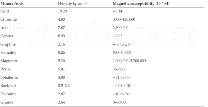
Mineral/rock Density (g cm−3) Magnetic susceptibility (10−6 SI) Gold 19.28 −0.14 Chromite 4.80 3000–120,000 Iron 7.87 3,900,000 Copper 8.90 −9.63 Graphite 2.16 −80 to 200 Hematite 5.26 500–40,000 Magnetite 5.20 1,000,000–5,700,000 Pyrite 5.01 35–5000 Sphalerite 4.08 −31 to 750 Rock salt 2.5–2.6 −0.01 × 10⁻³ Dolomite 2.87 −10 to 940 Granite 2.64 0–50,000
Table 2. Density and magnetic susceptibility of some minerals and rocks.
tends to have its own distinct geophysical identity requiring the adoption of appropriate geo-physical methods. Typically, more than one method is used in one survey, to decrease the ambiguity in deciphering the nature of unknown resources below the surface. Some impor-tant geophysical methods (Table 1) have been chosen in this chapter to demonstrate how we use these methods in mineral exploration.
3. Gravity method
The gravity method studies anomalies of the Earth’s gravitational field due to changes in den-sities below the surface. Density changes (density contrast) are induced by an occurrence of
Geophysical methods
Measured field Physical properties Units Typical minerals and applications
Exploration depth
Gravity Natural gravity
field of the Earth Density mGal Sulfides including sphalerite, barite, mining, hydrology, plate tectonics
All
Magnetic Natural magnetic
field of the Earth Magnetic susceptibility Remanent magnetization
nT Magnetite, ultramafics, iron-rich rocks, basin analysis, plate tectonics
Until curie isotherm
Self-potential Natural telluric current
Electrical conductivity
mV Metallic sulfides, serpentinite, graphite, water-filled shears, salt water
A few hundred meters
a causative body (target source) within the surrounding rocks. Rock densities are considered as one of the variables of all geophysical parameters. The density of rocks is dependent on both mineral composition and porosity. Table 2 shows examples of some mineral and rock density values. Gravity method can be used from the land to the air and in marine environ-ment. Gravity anomalies are due to anomalous density within the Earth. Gravity method has wide-ranging uses in mineral, hydrocarbon, cave, geothermal, and archeological investiga-tions [5–7]. The target of gravity interpretation is to locate and characterize the buried min-eral source parameters, in particular, the density contrast, depth, and shape [8–10]. Sevmin-eral methodologies are used to interpret gravity data [11–14]. More recently, three-dimensional modeling and inversion of gravity data provide more accurate results. In these days, new nonconventional methods are used such as particle swarm optimization, very fast simulated annealing, genetic algorithm, forced neural network, and differential evolution algorithm.
Table 2 demonstrates value of the density of rock and mineral examples.
4. Magnetic method
Magnetic method is one of the oldest branches of geophysics and used in many exploration issues such as mineral and ores as massive sulfide, iron, gold, and porphyry copper deposits. Magnetic data interpretation has shown its efficiency in the identification of deep and shal-low structures known to employ a structural control on mineralization occurrences [15, 16]. Uniform geological models (geologic contacts, thin sheets, cylinders, and spheres) are frequently employed in magnetic inversion to estimate the body factors (the amplitude factor, the depth, the index angle, the location of the origin, and the shape) and have a vital role in many exploration issues. These models cannot be an exact geologically representation, but are generally a good tool in magnetic interpretation to calculate, in particular, the body parameters. Several elucida-tion approaches of the magnetic data above inhomogeneous geological structures have been recognized. These approaches can be characterized into four categories as follows: Category I is the well-known two- and three-dimensional magnetic modeling and inversion for irregular structures. Category II is recognized by using residual magnetic anomalies only. Category III is relied upon using not only the residual but also the measured magnetic data. Category IV is dependent on utilizing the metaheuristic algorithms like the particle swarm optimization (PSO) method, the genetic algorithm (GA) method, the differential evolution algorithm (DEA) method, the simulated annealing algorithm (SAA) method, the ant colony optimization (ACO) method, and the neural network (NN) method. Magnetization directionally consists of adding induced and remanent components. Induced magnetization depends on the magnetic suscep-tibility of the material (Table 2) and the magnitude and direction of the Earth’s magnetic field, whereas remanent magnetization reflects the past magnetic history of the material.
5. Self-potential method
Self-potential (SP) is one of the passive geophysical techniques that measure the natural Earth’s surface electric potential happening by many reasons like the difference between minerals Introductory Chapter: Mineral Exploration from the Point of View of Geophysicists
and their hosting, bioelectric generation from plants, and electrochemical and electrokinetic. Sato and Mooney [17] demonstrated that this potential has different types as electrokinetic potential produced from the stream of a fluid with certain electrical properties going through a pipe or permeable medium with various electrical properties. In addition, several another mechanisms (diffusion, mineralization, etc.) produced this SP. The self-potential method has a wide range in different applications in exploration of geophysics, hydrogeophysics, and environmental problems and mineral exploration such as metallic sulfides, magnetite, graph-ite, and uranium. Several assessable elucidation approaches of the SP data over the buried geologic structures have been established. These approaches can be classified into two catego-ries. The first category is usually dependent on using simple geological models (spheres and cylinders) to appraise the parameters for buried structures and has a vigorous role in many investigation problems as linear and nonlinear least squares methods, moving average and gradient methods, depth-horizontal curve method. These models are not wholly geologically perfect, but they are often useful in SP interpretation to calculate the body parameters. The second category is dependent on two- and three-dimensional modeling and inversion meth-ods. However, a portion of these methods requires good initial parameters, using a few data point and distances, and requires more time.
Finally, the three potential methods (gravity, magnetic, and self-potential) mentioned above have been used to evaluate the source parameters but are suffering of ill-posedness and nonuniqueness in finding a global solution [18]. The usage of simple geometrical structures in gravity, magnetic, and self-potential inversion helps in overcoming some of these limita-tions, gives an optimal fit for the buried structures, and plays a vigorous role in solving many investigation problems.
6. Case studies
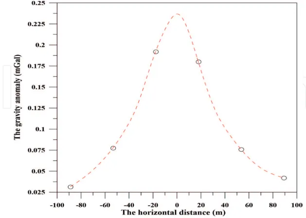
6.1. Gravity anomaly of chromite deposit body
Figure 1 shows the gravity anomaly of length 180 m over a chromite deposit body in the
chro-mite region of the Camaguey Area, Cuba [19]. This chrochro-mite deposits are found in a complex geological environment involving serpentinized peridotite and dunite with slight quantities of gabbro, troctolite, and anorthosite. This complex environment affected by metamorphic rocks and superimposed by upper Cretaceous volcanic rocks with limestone and radiolarian cherts. Severe compressive stresses, started in late Cretaceous or early Eocene time, deformed both the sedimentary rocks and the underlying ultramafic complex and culminated in exten-sive thrust faulting, probably in the late middle Eocene. Uplift and erosion have detached the overlying rocks from the serpentine except in synclinal areas, the largest of which extends from Central Lugareño to Loma Yucatan. This gravity anomaly has been interpreted by uti-lizing different inversion methods as demonstrated in Table 3. Table 3 demonstrated that the estimated chromite deposit body parameters, amplitude factor (A), depth (z), location of the body (d), and the shape (q) by utilizing these approaches, have a reasonable agreement especially the depth with that obtained from drilling.
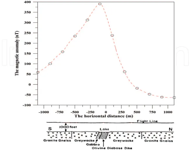
6.2. Magnetic anomaly over an olivine diabase dike
Figure 2 demonstrates the magnetic anomaly profile of length 2200 m above an olivine
dia-base dike from the Pishabo Lake, Canada, and this site is made out of plagioclase, purplish-brown augite, pale green olivine, apatite, some biotite, and large patches of magnetite [20]. This magnetic anomaly has been interpreted by using various inversion algorithms such as moving average method, parametric inversion method, and the PSO method. The elucidation procedure and their produced results are mentioned in Table 4. The predicted parameters (M which represents the amplitude factor, z is the depth, θ is the magnetization angle, d is the origin location, and q is the shape) of the body by using these inversion methods have a good agreement together.
Figure 1. The gravity anomaly of chromite deposit body (Cuba).
Parameters Drilling information Essa method [21] Biswas method [9] Ekinci et al. method [22]
Essa and Munschy method [23]
A (mGal m2) — 412.33 16.80 288.25 408.25
z (m) 21.00 21.02 42.30 23.23 21.15
d (m) — — −2.40 58.73 0.63
q (dimensionless) — 1.5 1.0 1.5 1.47
Table 3. The results obtained for interpreting gravity anomaly of chromite deposit body (Cuba) using different inversion
methods.
Introductory Chapter: Mineral Exploration from the Point of View of Geophysicists http://dx.doi.org/10.5772/intechopen.84830 7
Parameters McGrath and Hood method [20] Abdelrahman et al. method [24] Abdelrahman et al. method [25] Biswas method [26] Essa method M (nT) — — 1429.0 1411.8 1380.8 z (m) 304 318.9 320 324 305.9 θ (o) — — 37.5 −37.9 38.5 d (m) — 2.86 — 1.7 2.22 q (dimensionless) — 1.0 1.0 1.0 0.98
Table 4. The results obtained for interpreting magnetic anomaly over an olivine diabase dike from the Pishabo Lake,
Canada.
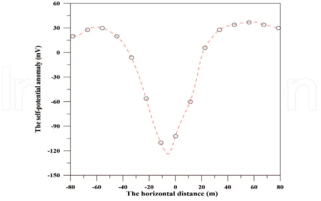
6.3. Self-potential anomaly of sulfide orebody
Figure 3 displays the self-potential anomaly of a sulfide orebody in the Sariyer area which
is located about 18 km north to Istanbul, Turkey, and characterized by an outcropping of andesite, pyrite veins, and cupriferous waters. The area of this investigation is characterized by a steep surface gradient. In 1951, the sulfide orebodies had been explored by utilizing
geophysical techniques where it found to lie under unmineralized schist or alluvium with a depth of 23 m and elongated as a spheroid dimension [21]. This profile has a length of 160 m and has been subjected to many interpretation methods to estimate the sulfide orebody parameters (K is the amplitude factor, z is the depth, θ is the polarization angle, d is the origin location, and q is the shape). The estimated results are displayed in Table 5. The estimated parameters of this source by exploiting these methods have a good covenant together.
7. Conclusions
The chapter discussed the importance of the geophysical methods, especially gravity, mag-netic, and self-potential methods, in mineral and ore exploration which are considered as an
Figure 3. The self-potential anomaly of a sulfide orebody in the Sariyer Area, Turkey.
Parameters Abdelrahman et al. method [27]
Asfahani and Tlas method [28]
Biswas and Sharma method [29] Essa method K (mV × m2) 3245.0 4695.6 2855.4 3447.1 z (m) 24.5 22.6 28.0 25.4 θ (o) −51.2 −82.9 −70.3 −58.9 d (m) — — −2.5 −0.5 q (dimensionless) 1.5 1.0 1.5 1.5
Table 5. The results obtained for interpreting self-potential anomaly of a sulfide orebody in the Sariyer Area, Turkey.
Introductory Chapter: Mineral Exploration from the Point of View of Geophysicists http://dx.doi.org/10.5772/intechopen.84830 9
important issue for many countries to increase their incomes. The results of the published information described in the state of arts mentioned above by the three case studies revealed the pervasiveness of these methods and its capability of elucidating gravity, magnetic, and self-potential data associated with shallow and deep mineralized bodies.
Acknowledgements
The authors would like to thank and express appreciation to Ms. Jasna Bozic, Author Service Manager, for her assistance and cooperation in this issue. The first author wishes to thank the Science and Technology Development Fund (STDF) and the Institut Francais d'Egypte (IFE) for providing their full support to finish this work.
Conflict of interest
There is no conflict of interest.
Author details
Khalid S. Essa1* and Marc Munschy2
*Address all correspondence to: khalid_sa_essa@yahoo.com
1 Geophysics Department, Faculty of Science, Cairo University, Giza, Egypt
2 Institut de Physique du Globe de Strasbourg, EOST, CNRS, University of Strasbourg, Strasbourg, France
References
[1] Haldar S, editor. Mineral exploration: Principles and Applications. 1st ed. Netherlands: Elsevier; 2018. 378 p
[2] Abdelrahman EM, El-Araby TM, Essa KS. A least-squares minimisation approach to depth, index parameter, and amplitude coefficient determination from magnetic anoma-lies due to thin dykes. Exploration Geophysics. 2003;34:241-248
[3] Khalil MH, Ahmed KS, Elnahry AH, Hasan AN. Integrated geophysical, remote sens-ing and GIS studies for groundwater assessment, Abu Zenima Area, West Sinai, Egypt. International Journal of Geosciences. 2014;5:882-907
[4] Chen Z, Mou L, Meng X. The horizontal boundary and top depth estimates of buried source using gravity data and their applications. Journal of Applied Geophysics. 2016;
[5] Essa KS. A fast interpretation method for inverse modeling of residual gravity anomalies caused by simple geometry. Journal of Geological Research. 2012;2012:327037
[6] Hinze WJ, von Frese RRB, Saad AH. Gravity and Magnetic Exploration—Principles, Practices, and Applications. 1st ed. Cambridge University Press; 2013. 525 p
[7] Deng Y, Chen Y, Wang P, Essa KS, Xub T, Liang X, et al. Magmatic underplating beneath the Emeishan large igneous province (South China) revealed by the COMGRA-ELIP experiment. Tectonophysics. 2016;672-673:16-23
[8] Essa KS. New fast least-squares algorithm for estimating the best-fitting parameters of some geometric-structures to measured gravity anomalies. Journal of Advanced Research. 2014;5:57-65
[9] Biswas A. Interpretation of residual gravity anomaly caused by a simple shaped body using very fast simulated annealing global optimization. Geoscience Frontiers. 2015;6: 875-893
[10] Mehanee SA, Essa KS. 2.5D regularized inversion for the interpretation of residual grav-ity data by a dipping thin sheet: Numerical examples and case studies with an insight on sensitivity and non-uniqueness. Earth, Planets and Space. 2015;67:130
[11] Kilty KT. Werner deconvolution of profile potential field data. Geophysics. 1983;48:234-237 [12] Stavrev PY. Euler deconvolution using differential similarity transformations of gravity
or magnetic anomalies. Geophysical Prospecting. 1997;45:207-246
[13] Abdelrahman EM, Abo-Ezz ER, Essa KS, El-Araby TM, Soliman KS. A least-squares variance analysis method for shape and depth estimation from gravity data. Journal of Geophysics and Engineering. 2006;3:143-153
[14] Abdelrahman EM, Essa KS. A new approach to semi-infinite thin slab depth determina-tion from second moving average residual gravity anomalies. Exploradetermina-tion Geophysics. 2013;44:185-191
[15] Essa KS, Nady AG, Mostafa MS, Elhussein M. Implementation of potential field data to depict the structural lineaments of the Sinai Peninsula, Egypt. Journal of African Earth Sciences. 2018;147:43-53
[16] Le Maire P, Munschy M. 2D potential theory using complex algebra: New equations and visualization for the interpretation of potential field data. Geophysics. 2018;83:J1-J13 [17] Sato M, Mooney HM. The electrochemical mechanism of sulfide self-potentials.
Geophysics. 1960;25:226-249
[18] Tarantola A. Inverse Problem Theory and Methods for Model Parameter Estimation. 1st ed. Philadelphia: Society for Industrial and Applied Mathematics (SIAM); 2004. 352 p [19] Roy L. Short note: Source geometry identification by simultaneous use of structural index
and shape factor. Geophysical Prospecting. 2001;49:159-164
[20] McGrath PH, Hood PJ. The dipping dike case: A computer curve-matching method of magnetic interpretation. Geophysics. 1970;35:831-848
Introductory Chapter: Mineral Exploration from the Point of View of Geophysicists http://dx.doi.org/10.5772/intechopen.84830 11
[21] Essa KS. A new algorithm for gravity or self-potential data interpretation. Journal of Geophysics and Engineering. 2011;8:434-446
[22] Ekinci Y, Balkaya C, Göktürkler G, Turan S. Model parameter estimations from residual gravity anomalies due to simple-shaped sources using differential evolution algorithm. Journal of Applied Geophysics. 2016;129:133-147
[23] Essa KS, Munschy M. Gravity data interpretation using the particle swarm optimization method with application to mineral exploration. Journal of Earth System Science. 2019; In press
[24] Abdelrahman EM, Soliman KS, El-Araby TM, Abo-Ezz ER, Essa KS. A least-squares stan-dard deviation method to interpret magnetic anomalies due to thin dikes. Near Surface Geophysics. 2009;7:41-46
[25] Abdelrahman EM, Abo-Ezz ER, Essa KS. Parametric inversion of residual magnetic anomalies due to simple geometric bodies. Exploration Geophysics. 2012;43:178-189 [26] Biswas A. Interpretation of gravity and magnetic anomaly over thin sheet-type
struc-ture using very fast simulated annealing global optimization technique. Modeling Earth Systems and Environment. 2016;2:30
[27] Abdelrahman EM, Saber HS, Essa KS, Fouda MA. A least-squares approach to depth determination from numerical horizontal self-potential gradients. Pure and Applied Geophysics. 2004;161:399-411
[28] Asfahani J, Tlas M. Interpretation of self-potential anomalies by developing an approach based on linear optimization. Geosciences and Engineering. 2016;5:7-21
[29] Biswas A, Sharma SP. Interpretation of self-potential anomaly over idealized body and analysis of ambiguity using very fast simulated annealing global optimization. Near Surface Geophysics. 2015;13:179-195