Designing the Livable Winter City by
B.E.S., Urban
Ann W. Knowles
Studies and Planning, University (1980)
of Waterloo
Submitted in Partial Fulfillment of the Requirements of the Degree of
Master of City Planning at the
Massachusetts Institute of Technology June 1987
© Ann Wigham Knowles, 1987
The author hereby grants to M.I.T. permission to reproduce and to distribute copies of this thesis document in whole or in part.
Signature of Author
Certified by
Depahment of Urban Studies and Planning May 11, 1987
Tunney F. Lee Thesis Supervisor Pmfessor. Urban Studies and Planning Accepted by
MA ss Trs srmm
(TECO#4LOY
(
Phillip L. lay Associate Professor, an Studies and Pla ning Chairman, Committee of the Master'sP gramAbstract
Winter cities in the U.S. and Canada seem to resemble cities anywhere else in North America, despite their differing climatic needs. Most of a city's built structure ignores the reality of winter, and in its form it makes winter outside less pleasant. This thesis gives some ideas about how to design public outdoor spaces in winter.
To provide a basis for designing, the positive imagery of winter and the climatic concerns that a designer must consider in working with outdoor spaces is discussed. Vernacular buildings and settlement forms often have dealt successfully with these climatic concerns. A discussion about them provides a basis for a history of development in Toronto, Ontario, the city used as a case study. Toronto's climatic planning policy and urban design initiatives are reviewed to show how the city currently operates and where it may be heading as a winter city.
The main body of this investigation is a handbook which is directed at planners, designers, developers, and citizens of Toronto, and concerns the development of outdoor public and semi-public spaces for winter use. Thesis Supervisor: Tunney F. Lee, Professor,
Acknowledgements
I would like to extend my thanks to Tunney Lee, my advisor, for his ideas and helpful criticism. Appreciation is also due to my readers, Gary Hack and John Furlong. I would also like to thank Xenia Zepic and Norman Pressman for supplying information and support. Finally, I am indebted to Harry Voorhees for his patient proof reading and Byard Knowles for help with the photos.
Table of Contents
Page
Introduction... 4
1 Positive Images of Winter ... 9
2 Practical Concerns of Winter... 15
2.1 Macroclimate... 16
2.2 Microclimate ... 23
3 Vernacular Buildings and Settlements... 30
3.1 Toronto as a Winter City ... 34
4 Climate-Related Policy in Toronto... 39
5 The Livable Winter City Handbook ... 54
5.1 Introduction... 54
5.2 Why is Design for Winter Necessary?... 54
5.3 Who Should Participate? ... 55
5.4 The Study Area... 56
5.5 Potential Activities in Outdoor Public Areas ... 57
5.6 Problems and Opportunities of Winter...60
5.7 Plazas and Outdoor Urban Places ... 67
5.8 Streets and Pedestrian Ways ... 76
5.9 Parks/Connections to the Region... 83
5.10 City-Wide Connections/City Form... 91
5.11 Summary ... 95
6 Conclusions ... 98
Source of Illustrations/Photo Credits... 103
Introduction
Winter is a special time. It evokes strong images at either end of the spectrum for all of us who know it. On the one hand there are cars throwing up slush onto unsuspecting pedestrians, traffic jams, bleak vistas of black and white skyscrapers; on the other there is the beauty of a sun-sparkling snowscape, the silence of a winter's night, and skating on the local pond.
In countries where winter is a fact of existence for the entire nation, these special associations of winter have taken on an even stronger meaning. The winter and wide open spaces of Canada have shaped the psyche of its people. Survival has been a constant theme of Canadian literature, poetry, and art (witness works such as Margaret Atwood's Survival, Gilles Vigneault's "Mon Pays" or Lawren Harris's iceberg paintings). It isn't difficult to conjecture that what Canadians survive is winter, for depending on where they live, Canadians endure five to ten months of it.
Canadians are moving away from a "survivor" image of themselves because they have been for some time an urban people. Nonetheless, there is always winter lurking nearby; a connection to the eternally wild. The cities and towns that many Canadians live in do not look too different from cities and towns elsewhere. This could be part of a problem. Here we have a season that dominates the life of a people and it is not reflected in the settings in which they live.
Our winter cities look like cities anywhere in North America. Skyscrapers define the skyline but fail to make a unique statement about the city they are in. Their modernist style looks bleak on a winter day. To build them, we have torn down historic buildings with their rich red, pink or brown colours and their intricate detailing. The effects of modern developments have slipped over into the outside environment; they feel placeless and unconnected.
Now, when we step out of tall buildings, we almost get blown over by a gusty and bone-chilling wind in the winter. As we walk the canyon-like streets, the buildings hide us from the faint warmth of the sun. The speeding cars in the street splash us with salty slush. Driving snow prevents us from seeing. Winter in the city has become something we shun. The warm places are unconnected. Parks are unused, designed as they were for the summer months. Those who can afford it fly south to warm places for a few precious days or weeks in the sun.
Even in the best of winter places, transportation costs more and is more difficult, heating bills are higher, communication is more difficult, individual and family social problems escalate, people spend more time inside, and they do not linger in the public outdoor places.
In recent years more people have become interested in these phenomena. Leaders in northern climates are now expressing an interest in dealing more
effectively with their winter cities. They want to increase todrism and decrease the exodus of people and jobs to the "sunbelt". Within the last few years, the Livable Winter City Association has been formed and conferences have taken place to address these and other issues. Investigation in this area seems especially timely.
What is a winter city? It has been defined variously by researchers as an area where "the underheated period of the year (relative to human comfort) is of such magnitude and duration that it is judged to require significant intervention by the built environment (in terms of structure and energy input) to ensure human survival"1 and where "the average January temperature is 32' F (0 C) or colder".2 Regardless, this takes in a lot of ground (see Figure 1). It covers most Canadian cities, not to mention cities in the U.S., U.S.S.R., Europe, and elsewhere. It also covers a lot of types of winter: snowy winters, slushy winters, icy winters, dark winters, and sunny winters.
This thesis investigates the problems and opportunities that winter creates in
a city setting. It looks at the implications for the design of outdoor urban spaces. Why outdoor? I work from the premise that the outdoor spaces,
1 Boris Culjat, "Climate and the Built Environment in the North" (Phd. thesis, Royal Institute of Technology, Stockholm, 1975), p. 3.
2 William C. Rogers and Jeanne K. Hanson, The Winter City Book, A
Survival Guide for the Frost Belt (Edina, Minn.: Dom Books, 1980), p.
21.
Figure 1: Winter city January temperature belts
more than any other, need to be more effectively treated in the winter city. Recent trends have been towards the enclosure of public space, and it is my contention that developers will ensure the continuation of these trends. The need for investigation lies elsewhere: outside. The need for connection to the outside and to nature increases as we are prevented from using it by factors such as climate.3 It is therefore incumbent on planners and designers to deal with these issues positively.
In the first section of this investigation, I look at the positive imagery of winter as a step towards discovering how these images might be incorporated into city design. The climatic concerns that must be addressed when dealing with outdoor environments are also introduced, especially those in Toronto, which will act as a case study. Then vernacular building and settlement forms are discussed, in terms of their sensitivity to both climate and context. This provides a background for a history of how Toronto developed and the effect that development had on the way Toronto operates in winter today. Toronto's climate-related planning policy is also reviewed in order to elaborate on the historical situation and indicate where Toronto appears to be heading as a winter city.
The last section of the thesis is a handbook, treated as an entity within itself. It is directed at planners, designers, developers, and the public who are interested in creating outdoor public and semi-public spaces that are usable 3 Boris Culjat, p. 68.
year-round. While Toronto is the focus of the study, the information provided may be more broadly applicable. The handbook reiterates the climatic concerns of winter and then uses a problem and opportunity format to discuss how outdoor spaces can be made more "livable" in winter.
1 Positive Images of Winter
Current images about winter are often negative: the weather forecaster reports cold and snow as if doom were descending, the newscaster concentrates on the accidents or the power outages, drivers groan when they see the results of the previous night's snowstorm. We need to rethink this attitude, in order to make winter more enjoyable. If we could adopt a positive attitude in our urban development, we would build richer, more lively, more informative and diverse environments. Our settlements would respond better to human needs for warmth and comfort in winter.
Winter is a major part of the existence of most Canadians. We should try to enjoy our reality. While winter sets important limits on our actions, it also provides us with a number of experiential opportunities.
Winter puts us in touch with raw nature in a way that we cannot ignore. Also, like the other seasons, it makes the rhythm of time clear, so that places that are fortunate enough to have demarcated seasons are further tied into nature. We are aware of our growth and the events of our lives as integrally connected to the change in the seasons.
The positive images we have about winter are often related to childhood memories, because our childhood is usually when we participate most fully
in winter (see Figure 2). As children we spend more time out of doors and seem to be more comfortable doing this than adults.4
Snow provides an ideal play accessory for children since it is so pliable and moldable. It becomes a snowball for throwing at people, or a snow fort to hide behind when attacked, or a snowperson to dress up with a carrot and muffler. Soft fluffy piles of new fallen snow can be jumped into or flattened into angels. Packed hard, snow provides a surface for tobogganing, sledding or skiing.
For either adults or children, falling snow can be a beautiful sight as it drifts gently down. Each flake is different, each has a special geometry caused by the constraints of space. After a storm, snow and ice coat the houses and the trees. The world looks simpler, cleaner, and more elemental. Expanses of unbroken snow twinkle and shimmer in the sunlight (see Figure 3).
The sound of snow is special too. Fresh hard packed snow squeaks when walked upon. The wet snow of a snowball thuds as it lands. Hails clatters. Crusty snow crunches as it is broken. Loosely packed snow quiets the surrouqding noises.
4 Boris Culjat and Ralph Erskine, "Climate-Responsive Social Space: A Scandinavian Perspective," Environments, Vol. 15, No. 2 (Waterloo: University of Waterloo, 1983), p. 15.
Figure 2: Children at play on a winter day in the St. James neighbourhood of Toronto.
Snow creates a sense of isolation that need not be considered a bad thing. When the roads are blocked and the trees bent over with ice, there is a certain cozy feeling about being in a warm, snug house or a warm, snug coat. The clarity and stillness of a winter's night contributes to a sense of isolation, of being alone with the beauty of the sparkling stars.
Ice turns into icicles that children use as swords or as (forbidden) sources of drinking water. Icicles also look beautiful hanging from the edges of snow-covered houses. Ice can be skated or slid upon. In the early spring, when an icebound river breaks up, huge blocks of ice are thrown up onto the riverbanks, providing children with a magical city of adventure.
Winter makes things look different. Houses are revealed from behind the trees. The river can be crossed on foot and new perspectives are possible. In ravines, whole areas that may be impassable and boggy during other seasons can be become open to access and their secrets known.
Then there are the winter sports: downhill and cross-country skiing, skating, snowshoeing (although this isn't frequent in the city), and tobogganing, for example. Most of these activities are undertaken in a group or family setting. The fresh cold weather can bring out a certain camaraderie among those who have an affinity for it. Winter sports allow us to socialize at an otherwise isolated time of year, so they are all the more
Figure 3: Idyllic winter scene with expances of unbroken snow
11
...
special for this. During or following these activities, there are wonderful warming liquids, such as hot chocolate, hot cider or mulled wine.
Much of what makes activities that accent the thermal sense special is the contrast between warm and cold. Lisa Heschong points out that people seek extreme environments for recreation, so that, for instance, the Finnish will run from the sauna and roll in the snow:
There are probably two reasons for having the extremes right next to each other. The first is physiological: the availability of extremes ensures we can move from one to the other to maintain a thermal balance. This gaves us the safety to enjoy fully both extremes. We can be greatly overheated for a while and then chilled to the bone, all without threatening our health...
The second reason to have thermal extremes close together might be termed aesthetic. The experience of each is made more acute by contrast to the other.5
Poets and artists often have a magic way of portraying winter scenes in a positive light. In Canada, the Group of Seven helped define a Canadian way of painting and winter which was a common source of inspiration. One night mention the powerful whites, blues, and grays of some of Lawren Harris's iceberg paintings, but there are a number of urban paintings that are more along the lines of inquiry here. His picture entitled 5 Lisa Heschong, Thermal Delight in Architecture (Cambridge: MIT Press, 1979), pp. 21-22.
"Old Houses, Toronto, Winter" is shown in black and white here (see
Figure 4) but the original shows the wet brown-black of the tree, the clear -blue wash of the sky, the creamy yellow stucco, the red of the sills, and the
blue of the shutters. The painting shows just how much colour is possible in winter. The snow itself looks luminous. Here, winter does not look bleak at all. The lively colours of the old buildings give us something to aspire to in new development.
Poets clearly have a preference for portraying winter in the country, where it is more pristine, but they do write poems with urban winter themes. Snow is shown as something pure, silent, and light. In a city, it is described by poets as an equalizer: something that hides differences. Here is a poem by
Raymond Souster that shows the lazy, floating quality of snow: Figure 4. Lawren Harriss "Old Houses, Toronto, Winter" has bright
Night of Snow touches of colour. We need colour in
slow-drifting down our winter environment and should
drifting shifting and piling over encourage it in our urban design.
streets, fences, houses, skyscrapers, till all the world is swallowed up by one last fragile shivering flake of snow.6
6 Raymond Souster, "Night of Snow," in The Colour of our Times,
(Toronto: The Ryerson Press, 1964).
Others write about snow's muffling qualities, and how it can quiet the noise of a city 7 or its "white geometry" 8. These are images that we need to draw upon as we begin to design for a winter city.
We need to "strive for a more intimate, even symbolic, relationship with natural forces".9 If we could make this relationship explicit, winter might be seen to provide a sense of delight, of wonder at its beauty, its breathtaking coldness, and its control over humans. If winter could be made to be a pleasant and exciting experience in our cities, it would become just as precious a season as the summer is to Canadians and there might be less of a need to escape the city for warmer places. Cities and towns in Austria, Switzerland, and elsewhere have based a successful tourist industry on the special virtues of winter. This could happen in certain North American cities if winter became a focus for further architectural or urban design inquiry. We will examine how this focus might be achieved in the handbook which follows.
7 Robert Bridges, "London Snow" in F.T. Palgrave, The Golden
Treasury of the Best Songs and Lyrical Poems, ed. F.T. Palgrave (New
York: The New American Library, Inc., 1961), p. 385.
8 R.A.D. Ford, Needle in the Eye (Oakville, Ont.: Mosaic Press, 1983),
p. 84.
9 Lisa Heschong, p. 56.
2 Practical Concerns of Winter
If our purpose is to create conditions whereby people can be encouraged to use the outdoor winter environment more than they do now, we need to know something about that environment as it exists now. In this section, I
will take a brief look at some important climatic variables that should be considered when designing sites for winter use: sun or radiant heat, wind, air temperature, precipitation, and relative humidity. (The latter, although important to human comfort, is difficult to control through design, and is less of an issue in winter than summer. It will be indirectly discussed in connection with wind and precipitation.) I will also talk about climate particular to the case study of Toronto.
The climatic variables mentioned above work together to form the general climate. Humans respond to the climate by altering the environment or themselves to be as comfortable as they can under given circumstances. They don heavy or light clothing as necessary, they modify their activity level and they build their structures to provide climatic comfort. Various attempts have been made to measure the human perception of comfort. One of the most successful has been Victor Olgyay's bioclimatic chart because it reflects graphically the interaction of more than one climatic variable (see Figure 5) to produce comfort or the lack of it. Of course, the idea of
comfort varies for different individuals, cultural groups, sexes, and age groups. The chart shown is based on assumptions that a person is in shade in a moderate climatic zone in the U.S. at less than 1000 feet above sea
*C leg 377 21.r loo' 4) u' ~-: 44 o d i2 d 4: sreawie htumVdrtt
Figure 5: Schematic of the bioclimatic chart: This chart shows that any winter city falls well outside the comfort zone. Some combination of clothing, activity levels, shelter, or protection must be provided in order to make a winter environment tolerable.
level. The person is wearing light clothes (unlike our winter situation) and is sitting or doing only light work. The comfort zone is in the middle of the chart, where temperatures range approximately from 210 to 26' C and relative humidity is roughly 20-75%.
Since Toronto winter weather quite obviously falls outside the comfort zone, climate modification is required. A combination of radiant heat, clothing, and wind control (relative humidity can often be considered in relation to the wind) can compensate for low air temperatures. The outdoor environment can be manipulated either through natural or built systems for this purpose, as will be discussed in later sections.
Olgyay's chart was one of the first and most popular bioclimatic charts. Other more recent ones take varying levels of clothing and activity and plot these against a number of climatic parameters. Fanger's charts, in particular, may useful for a winter situation.4
2.1 Macroclimate
Any site or place in the city is subject to macroclimatic conditions, which are the larger climatic influences affecting a country or large region. Since the handbook which follows concerns Toronto, it is useful to describe the 4 See ASHRAE, Handbook of Fundamentals (New York: ASHRAE, 1977), p. 8.1- 8.33; and P.O. Fanger, Thermal Comfort (New York: McGraw-Hill, 1972).
macroclimate of the city and the province of Ontario. Toronto is located in Southern Ontario on the shore of Lake Ontario (see Figure 6). Southern Ontario's climate is classified as "modified continental", which means that it has dry, cold winters and warm summers.5 Most of downtown Toronto
falls within the Lake Ontario Shore climatic region of Ontario, and the rest of the metropolitan area lies within the Southern Slopes region (see Figure 7). Both areas are affected by the lake itself. Differences are due to the inland and upland location of the Southern Slopes region.
Air Masses and Air Temperature
Variations in air temperature are largely the result of the amount of incoming solar radiation. Temperatures change during the course of a day for this reason. They also change depending on whether or not the sky is overcast or clear, with overcast days showing less variation in general. The direct path of energy from the sun on a clear summer day causes the temperature to be warmer than on a cloudy summer day. However, a cloudy day in winter will be warmer than a clear one, since the clouds reflect heat which would have escaped back to the ground.
In general, three major air masses affect Toronto; cold, dry ones from the north, which dominate in winter; warm, humid ones from the Gulf of 5 Moorhead Fleming Corban Inc., Landscape Planning for Energy
Efficiency, for Ontario Ministry of Energy (Toronto, 1982), p. 6.
Mexico, which occur often in the summer, and varying air masses from the west. Storms that are associated with these air masses are more intense and create more cloud cover in winter than in summer. As a result, Toronto records fewer hours of sunshine in winter than summer.6 In Table 2.1,
the main characteristics of the Lake Ontario Shore climate and the South Slopes climate are shown.
The Lake Ontario Shore climatic region probably does not extend as far as it would in the case a rural area. The roughness created by a built-up region limits its effect. Nonetheless, Lake Ontario exerts a strong control for perhaps one half mile inland, and weaker control for a much larger area inland. In fall and early winter, the lake will be much warmer than the land. Air is warmed in passing over the lake, and clouds form downwind over the city. In this area, sunshine is deceased for 1-2 hours/day, but temperatures are warmer than they would be elsewhere. The opposite phenomenon happens in spring and summer, so that sunshine is increased 1/2 to 1 1/2 hours a day over those locations unaffected by the lake, and temperatures are cooler.7
6 Marshall Macklin Monaghan Ltd., Climatic Informationfor Energy
Conscious Planning, for Ontario Ministry of Energy (Toronto, 1981), pp.
3-11, 3-13.
7 Marshall Macklin Monaghan Ltd., p. 3-14.
Figure 7: Climatic regions of Southern Ontario; Toronto falls within the Great Lakes Shore and South Slopes climatic regions.
Table 2.1 Selected Climate Characteristics for Toronto
Climate Region Lake Ont. Shore South Slopes
Characteristics:
Altitude (ft above sea level) 300 700
Mean Annual Temp. ('F) 45 45
Mean Daily Max. Temp. (*F): January 29 28
April 51 52
July 81 81
October 58 59
Mean Daily Min. Temp. (*F): January 13 13
April 34 33
July 59 58
October 40 39
Daily Range of Temp. ('F): January 16 15
July 20 23
Extreme Low Temp. ('F) -30 -39
Extreme High Temp. (*F) 104 105
Mean Date of Last Frost (Spring) May 12 May 15 Mean Date of First Frost (Fall) Oct. 8 Oct. 5 Mean Ann. Frost Free Period (Days) 150 145 Start of Growing Season April 12 April 13
End of Growing Season Nov. 3 Nov. 3
Mean Ann. Length-Growing Season 205 205
Mean Annual Precipitation (Inches)
Mean Annual Snowfall (Inches) 3465
30-38 70
Sun
The sun's energy arrives at the Earth in the form of energy waves. By the time it arrives, much of it has been reflected back to space by the Earth's atmosphere, but the ability to capture even a small fraction of what is left over can mean a great deal in the colder months. In an urban area like Toronto, further losses occur due to pollution. Toronto receives 15-20% less solar radiation than the neighbouring suburb of Scarborough.8 Ultraviolet radiation may be lowered by 30% and the duration of sunshine may drop by between 5%-15% due to increased cloud cover caused by pollution.9
The theoretical intensity and duration of solar radiation is affected by the latitude because it has a bearing on the angle of the sun's rays as they hit the ground. The sun's rays hit at an oblique angle at northern latitudes (see Figure 8). This in turn has a significant effect on air temperatures. Toronto is one of Canada's most southern cities. However, at Toronto's latitude (roughly 44'N), the sun still has a relatively low angle of altitude during the winter. This is angle ABC in Figure 8a. Toronto's December 31 angle of altitudp is approximately 22.5" and the June 21st angle is approximately 8 Marshall Macklin Monaghan Ltd., p. 3-9.
9 H. E. Landsberg, Weather, Climate and Human Settlement, Special Environmental Report No. 7 (Geneva: World Meteorological Organization,
1976), quoted in Marshall Macklin Monaghan Ltd., p. 2-26.
Angle ABC is the angle of altitude, or the altitude of the sun above the
horizon.
69.5. The actual amount of sunlight received varies depending on cloud cover and atmospheric turbidity.
In the city, the heat generating buildings, people, and activities, such as transportation, tend to create the urban heat island, especially under clear condition with light winds. Large concentrated urban areas like Toronto show the greatest effect. This may be useful in winter, because outdoor temperatures are raised, but it is not necessarily desirable in summer. The extensive use of natural materials (trees, grass, etc.) will reduce the extreme temperature variations. Plants and trees moderate extreme air temperatures through evapotranspiration, insolation, low albedo, and high conductivity.
Wind
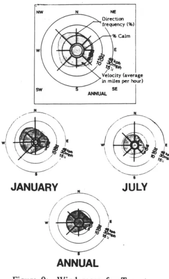
The wind is an also important factor to consider at the macro and micro-climatic scales. In winter it strongly affects heat loss from warm surfaces and in summer it aids in cooling through convection (the movement of air upwards, away from a heated surface, and its replacement with cooler air below) and evaporation. The wind roses for Toronto show its direction, velocity,1 and frequency in January, July, and annually (see Figure 9).
The winds in an unobstructed area, such as the country, are governed mainly by the regional (macro-scale) wind. At a certain height, the regional wind is completely unaffected by the surface of the land. At lower levels, this wind swoops down over the land and is slowed by the friction of the
JUL
JULY
JANUARY
ANNUAL
Figure 9: Wind roses for Toronto: These show that the predominant winter winds are north, west, and southwest. Wind speeds are highest from the northwest and west. It is slightly windier in January than in July, as evidenced by the per cent calm circle.
surface. The wind is decreased by a greater or lesser amount depending on the roughness of the land. An urban setting, with its buildings, other structures and trees, creates more drag than open fields or water (see Figure 10).
In urban areas, a light wind will be produced by the urban heat island. This is also a form of convection. The cooler air in this case comes from the suburban or rural areas (see Figure 11).
Precipitation
The amounts of snow and other forms of precipitation are shown in Table 2.1. Toronto is fortunate that it is not affected by the snowbelt effect of certain other parts of the Great Lakes. This effect occurs when air is heated as it crosses a major body of warm water, absorbing more moisture than it would over the drier, colder land. As the air passes over the cooler land on the other side of the lake, the air cools and loses its capacity to hold moisture. The moisture falls as snow or other precipitation on the downwind land locations. Toronto is spared when winter winds are from the noirth and west over land and suffers only minimally when they are southwest, because the unimpeded stretch across Lake Ontario is comparatively short in this direction.
An urban area has an impact on the amount of precipitation and cloudiness, in part because it is usually more polluted. Particulate encourages the
cb
cntre-cqen ccLur* ---22 00 Wind set
Figure 10: Wind speed changes with variations in surface roughness. Wind speeds are generally lower in built-up conditions than in the country. The regional wind speed (z ) is the wind that is unaffected by the fction of land. It is therefore attained at a higher height over the city than is the case in the country.
~~'A--+ -N /
Figure 11: Urban air circulation in calm conditions
formation of droplets and these quickly turn into precipitation--this is one of the ways the sky is cleansed. As a result of this process, Landsberg indicated that there is 5-10% more total precipitation and 5-10% more cloud cover in cities than in rural, unpolluted locations. He also suggests that there is 5% less snowfall. This occurs because of the urban heat island which allows air to retain more water than in rural areas. The two phenomena in combination lead to an increase of city fog in winter of
100%.10
2.2 Microclimate
Notwithstanding the larger climatic influences, a site will also be affected strongly by microclimatic, or localized (site) modifications of the macroclimate which occur due to topography, cover, ground surface, and structural form.II In particular, the microclimatic characteristics of an urban area are much different than those of the countryside. Conditions may vary radically from block to block.
10 H.E.Landsberg, "Climate and Urban Planning," W.M.O.: Technical Note No.108, p. 372, in Marshall Macklin Monaghan Ltd., p. 2-26.
11 Kevin Lynch and Gary Hack, Site Planning, 3rd ed. (Cambridge: MIT Press, 1984), p. 49.
Air Temperature
Wide variations of air temperature may occur on a site due to changing surface types or slope changes. Peak daily temperature is usually achieved two to three hours after solar noon, provided that the sun continues to reach the site. It falls off as the energy lost from the earth begins to surpass the energy received from the sun, usually after sunset. Air temperatures are controlled by conduction, as described below, under Sun/Radiant Heat, and by convection, described previously. On a local level, trees, shrubs, and other plants can moderate extreme air temperatures, but they must be grouped in order to have any significant effect. Air temperatures above large bodies of water also vary less and change more slowly than those over land.
Topography in combination with the lake effect is also important in determining air temperatures. In general, temperatures drop with decreasing altitude. With a lake however, this effect is superceded until 5-6 miles inland. Figure 12 indicates how valley areas in Toronto, other than those near Lake Ontario, shown to the left of the graph, have significant drops in temperpature inland.12 These measurements were taken on a clear winter's
12 H. E. Landsberg, "Climate and Planning of Settlements," Convention Symposium 1, Urban and Regional Planning, The American Institute of Architects, Washington D.C., May 1950, in Victor Olgyay, Design With
Climate (Princeton: Princeton University Press, 1963) p. 45.
20 15 10 aoL 0 -10 -13 4oo 400 300 a 200 a M I L E S
Figure 12: Effect of land formation on temperature distribution: Lake Ontario is the low elevation on the left, where temperatures are quite warm. Temperatures drop significantly 5 and 7 miles inland due to valleys.
night. Tall buildings can affect air temperatures in much the same manner as valleys do, producing cold sinks.
Sun/Radiant Heat
The orientation of a site will affect the amount of sun available. Spaces oriented towards the sun, with no shadowing by obstructions will, of course, receive the maximum available sunlight.
Slope also has an important effect with respect to the sun's intensity, especially at the middle latitudes, such as Toronto's. South facing slopes are warmer and drier because they are closer to perpendicular to the sun. Even small slopes of 5% can change the environment sufficiently in the early spring to cause snow melt when flat areas remain covered. A north facing slope will remain snow covered for longer than flat land since it receives much less radiation.
Albedo (reflectance) properties of building materials, the ground, and snow affect the amount of heat available. Generally light and glossy surfaces such as, fresh snow reflect most of the sunlight that hits them and have high albedos. Fresh snow may have an albedo of 0.95 while old snow has albedos closer to 0.40.13 Darker matte surfaces absorb more sunlight.
Albedos for clay soil are 0.20 to 0.30 and for black asphalt, as low as 0.05.14
Absorption into a material from the surface is called conduction. This property is important to this discussion because it represents the earth's ability to warm itself. Materials with high conductivity absorb and emit heat well. Those with low conductivity, such as snow, are good insulators. As Lynch and Hack point out, the conductivity of natural materials will lessen with dryness and density, in the following order: wet sand, ice, concrete, asphalt, still water, dry sand or clay, wet peat, fresh snow, still air.15
The dark, hard materials of cities, such as stone, brick or asphalt, absorb heat quickly, store it in greater quantities and re-radiate it slowly due to their large mass and density. However, because they do not transpire or create shade, and they have a lower moisture content, they create more extreme microclimates than does natural ground cover.
14 Kevin Lynch and Gary Hack, p. 49. 15 Kevin Lynch and Gary Hack, p. 50.
Wind
In winter, winds will generally lower temperatures and decrease the humidity by evaporation and thereby affect human comfort in outdoor areas. People find that wind speeds greater than 5 m/s (11 mph) are uncomfortable, especially in combination with low air temperatures and limited sunshine.
Urban areas are subject to some unusual wind effects. Tall buildings can bring a regional wind down to the street level (see Figure 13). Streets with buildings of uniform height and regularized setback will funnel wind at increased speed along them. However, the conditions at a particular site are difficult to predict because of the complexity of the urban fabric. As a result, the surest means of determining the effect of a building is to perform a wind tunnel test.
Natural vegetation modifies wind flows depending on its size and density. Plants can channel, divert, block or filter wind, depending on their orientation with respect to the prevailing wind direction (see Figure 14).
Precipitation
Usually the microclimatic concerns with precipitation involve a combination of factors, such as rain and stormwater drainage or retention, or snow and wind. Localized landforms affect how and where water drains or snow
Figure 13: Urban wind conditions near tall buildings
Airflow In the vicinity of a tall building with smaller buildings
upwind. The stippled areas delineate areas of substantially
drifting occurs. Snow collects wherever the wind slows and drops its load. This occurs both front and behind barriers such as walls.
Less rain that falls on an urban site is absorbed into the ground than in a rural area because of the large amount of pavement and built-up land. Instead, water that does not evaporate runs overland to drainpipes, sewers, catchbasins, etc. Urban storm drainage becomes a potential problem. Flooding and pollution increase when storm sewage is released into a river or basin. In winter, flooding is rarely a problem. The precipitation is stored in the form of snow, wherever it lands and blows. It must then be collected and moved to locations that do not inconvenience the movement of people and traffic.
Plants reduce drainage and storage needs to a certain extent. In summer, leaves catch rain and roots absorb it, therefore increasing the capacity of the natural system to handle water. In winter, branches and needles hold and store snow, and so modify environments near them.
In suminary, climate either facilitates or limits the opportunities available to us outdoors. In a snow storm we may not even venture outside or we only go out if we absolutely must. If the urban environment is inadequately designed or poorly maintained an unpleasant microclimate may result, so that opportunities are limited even in the best winter weather. On the other
FCt t
Dr1r,
i Pice
Figure 14: The effect of natural vegetation on wind
hand, climate introduces recreational opportunities such as skating or skiing.
The ideal urban outdoor environment maximizes the ability to be outdoors in winter and to interact with people and the environment. It minimizes the limitations of cold, wind, and ice. In the handbook, I will elaborate on how design methods and ideas can be used to modify the microclimate and hence facilitate outdoor activity.
In recent years, researchers have rediscovered the vernacular built form and its positive qualities. One of the positive qualities is said to be its ability to respond appropriately to the microclimatic concerns just discussed. In the next section, vernacular buildings and settlements are investigated to see what lessons we can learn from them.
3 Vernacular Buildings and Settlements
It is instructive to look at indigenous building forms to reflect on what lessons they provide for a more climate-related way of city building. Indigenous building methods often acknowledge the climate in ingenious ways. The older city forms are now seen to be more sensitive to human comfort and culture than the technological planned city that many of us live in.16 We need to recapture the spirit of these settlements in today's development.
Historically, humans have used the materials available to them in order to protect themselves from the elements. People responded to the world of limited local resources and natural energy by producing vernacular buildings. Adaptation to the climate was, to a large extent, a necessity of survival, so it had a visible effect on architecture and community form, from extremely warm to extremely cold places. The derived solutions resulted from cultural norms and generations of experimentation and adaptation to find what worked best under the constraints faced by the builders. These solutions often became rules of building,17 contradicted at great cost to both
the culgure and the individual. The vernacular building in hot, dry places,
16 Norman Pressman and Xenia Zepic, Planning in Cold Climates: A
Critical Overview of Canadian Settlement Patterns and Policies., Institute
of Urban Studies (Winnipeg: University of Winnipeg, 1986), p. viii.
17 Hassan Fathy, Natural Energy and Vernacular Architecture, United
Nations University (Chicago: The University of Chicago Press, 1986), p. 7.
for example, generally tended to have thick walls, with tiny windows that allowed access to light but minimized heat gain. The community layout was dense, with narrow streets and tall buildings, again to minimize sun on the
street and to reduce surface exposure.
In a northern area, like Switzerland, the buildings often had steep gables to handle the heavy snowfall. The Swiss farm, for example, contained all its major functions under a single roof. The barn animals below warmed the people on the second floor, thus conserving and maximizing the use of valuable heat.18 The Swiss mountain town was, like the Arab settlement, closely packed, in this case for warmth and wind protection. The building heights and densities, though, allowed for solar access.
Since this investigation involves the winter reality of Canada, it is also important to consider vernacular examples from there. The Inuit building methods provide an excellent illustration of resourceful adaptation to a severe climate. The French Canadian settlements exemplify how their built form changed in response to a new climatic situation.
The wipter housing the Inuit used, and sometimes use still, was the igloo, made of blocks of fined grained compacted snow. The blocks spiral upwards and slope inwards towards the domed top. Use makes the igloo more leak-proof, for the heat generation inside causes the inner walls to melt
slightly and they later refreeze into solid ice. Snow is a wonderful insulator, so the heat inside the igloo is preserved. The entrance allows for graduated introduction to heat or cold (see Figure 15), important for health reasons. Cold sinks down below the seating platform and is drawn out of the entrance area because of pressure differentials created by winds at right angles to the igloo. Inside, on top of the platforms, temperatures of 150 C
(60* F) are possible, even when exterior temperatures are -46' C (-50' F). Heat and light are provided by body heat and by burning seal oil. The igloo, then, is a very efficient structure. As Culjat says:
In terms of heat losses, the Eskimo dwellings ... utilize the principles of least surface enclosing the greatest volume, least surface exposed to the cooling effects of the wind, thick walls to retain heat, minimal openings, [and] vertical off-setting of spaces to ensure that warm air is trapped in the living area.19
When several Inuit families spent their winter in the same place, they joined their igloos with galleries. This communal arrangement saved heat (see Figure 16).
In the Province of Quebec historic settlements were densely built, using the same rpethods as used in France. Over time, the builders made a number of adaptations to the traditional French building forms which better suited the extreme climate that the French Canadians had to deal with. For instance, Ramsey Traquair describes how verandahs began to appear on
19 Boris Culjat, p. 55.
Figure 15: Section of igloo showing gradual temperature changes. Cold air sinks off the seating platforms and is drawn out side by cross winds passing by the entrance. The entrance of the igloo is deliberately constructed perpendicular to the predominant winds to achieve this effect.
French housing because they furnished protection from the sun in summer and snow in winter.20 Likewise, the mansard roof was extended to deal with the heavy snowfall. The adaptations eventually created a distinctive French Canadian style of housing. On this subject, Pressman and Zepic have stated:
While the French created settlements which supported community life during the winter season, many British settlers lived in isolation, usually in dwellings built in the middle of their properties, miles from civilization.
In time, the French learned how to cope with (and to enjoy) the cold
season; their British counterparts suffered through it. The Figure 16: A group of connected architecture of Quebec reflects the climate and the building materials igloos. The shaded areas are the
of the region.2 1 seating platforms. Exterior igloos are
the family units. Interior ones are communal gathering and storage areas. These exact buildings types and community formations are not appropriate
for the twentieth century technological world, because while the climate may remain the same over time, culture is modified by the events of history. However, the principles that underlie the forms can be extracted for the purpose of discovering what constitutes livability in the winter city. The principle of maximizing energy savings for the material used is one important thing we can learn.22 At the communal and architectural levels,
20 Ramsey Traquair, The Old Architecture of Quebec (Toronto: 1947) in Boris Culjat, p. 54.
21 Norman Pressman and Xenia Zepic, p. 42. 22 Boris Culjat, pp. 41, 57.
some elements of this principle are the use of small spaces, minimal openings, massive materials, access to the sun and multi-use structures, and the creation of a sense of enclosure. Another principle is that of providing orientation and a means of identification with a place, as the French did with their gradual adaptations.2 3 Yet another is furnishing better contact with
nature, so that people can live more in concert with it, as the Inuit did. This leads us to the topic of the case study. How did Toronto evolve and is its form conducive with the winter weather that it has to face?
3.1 Toronto as a Winter City
Toronto developed as a number of Canadian urban settlements did, as a planned English settlement beside a military reserve. It was laid out based on the Roman practices of town-making that the English used as a matter of expediency in colonial development. The directional grid was, in part, a reaction to the congested conditions in cities like London. The roads were wide and the lots spread out.
The grid was filled in and extended gradually throughout the nineteenth century. It was clearly not the best type of urban form for handling the winter weather that the little community faced and quite obviously different from the French Canadian settlement form discussed above.
The British adapted the architectural forms of their home country with fewer concessions to the climate. Their architecture symbolically proclaimed their loyalty to England and their independence from the U.S.A. Yet in Toronto, the architecture and layout of the site was not completely inimical to winter survival. For one thing, the limited extent of the townsite made it traversable in the worst winter conditions. Moreover, it was well connected to its hinterland by way of Yonge Street leading to the north, so the area was a popular one with both urban and rural settlers. Clearly, the urban form was not so disadvantageous that it discouraged development. It worked, however, because this is what the British immigrants and Loyalist
settlers were accustomed to.
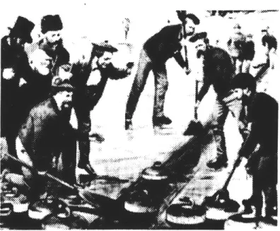
People weren't completely miserable either. They quickly adapted or created new sports to entertain themselves during the long winter. In the middle to late 1800's, sleigh-racing, and later ice-boating, on the frozen Toronto Harbour were popular with the wealthy. Throughout that century and into our own, curling and ice skating were common winter activities (see Figure 17). Later, hockey became Toronto's and Canada's most beloved sport.24
24 J.M.S. Careless, Toronto to 1918, An Illustrated History (Toronto: James Lorimer and Company, 1984), pp. 96, 141, 175.
Figure 17: Curling on the Don River, in the 1870's. Curling has remained a very popular sport in Canada, although it is now played almost exclusively on indoor rinks.
The arrival of the streetcar in the 1870's to 1890's and cars in the twentieth century (the major road network extensions occurred in the 1950's) caused the continuing expansion of Toronto. Toronto has long since lost the compact form of its initial settlement. In an era of proliferating development, its easily extendable form has turned into a liability.
In the twentieth century, Toronto, in its planning and architecture, strove to prove itself a member of, first, the Canadian community, and later, the world community. It has continued to derive its architectural form primarily from elsewhere, as has most of the rest of Canada (although this is beginning to change). A core of tall buildings, designed in the International Style, were erected in response to the local desire for broader recognition (see Figure 18). Many of these are quite utilitarian looking and unimaginative. They are rendered grey and unmemorable in snowy, wet weather. No local or Canadian architecture has ever developed that is sensitive to its winter climate. Nor has the urban design profession created a unique local response to the development of public and outdoor spaces, although certainly some good designs exist.
Urban prawl, tall buildings and wide wind-swept streets have brought some very special problems. Today, Toronto has some public spaces, such as City Hall plaza, that are a delight even in winter, but many areas are not. Crossing the street at St. Clair Avenue and Yonge Street is difficult in a winter blizzard. Neither is it easy or enjoyable to walk across the podium and into any one of the tall buildings at King and Bay Streets. In both
Figure 18: The black, grey, and white skyscrapers that form Toronto's business core.
locations, the wind whips up to speeds that are disconcerting and even dangerous to the pedestrian.
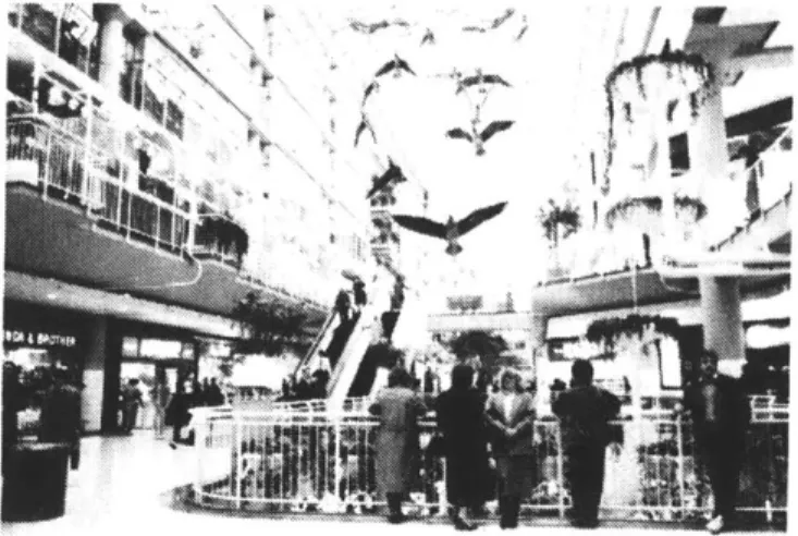
Toronto turns inward in winter. This is partly a cultural response of its citizens which should not be considered a bad thing. However, it is also a physical reaction to unpleasant conditions. Toronto's underground walkway systems link up most of the main office buildings in the financial system and a good part of the Yonge Street and Bloor Street retail districts as well (see Figure 19). People use these connections whenever possible. Use of the commercial streets is therefore severely curtailed. When activity disappears from the street, it seems even colder and less enjoyable.
The downtown parks are also underutilized in winter, perhaps because most of them are too small for the Parks and Recreation Department to program extensively (see Figure 20). Most were not planned with winter in mind. Larger parks, such as Harbourfront, are hard to get to because the pedestrian connections are so cold and windy. The waterfront parks especially suffer from the fierce winds that come off the lake. Other parks,
such as Ontario Place, aren't even open in winter.
In general, Toronto has tended to deny the reality of winter, as have a good many other northern cities. Torontonians complain without end about winter weather but few do much about it. They spend much of their time indoors. Jack Royle, a Torontonian, described northerners as having a "cold-climate mentality":
Figure 19: Inside a mall in Toronto's underground walkway system.
Many of us live a kind of half life, indulging ourselves in the good things served up by our northern lands through half the year and pretending the other half away. We turn our backs on the rich diet of joys and sensations offered in our cold and snowy season, thus reducing the quality of our living and our experience. We live in badly designed cities and communities -badly designed in terms of their adaptation to our climate - and decline to insist that our architects and planners can do better by us.25
It is time now to insist on something better, armed as we are with the principles of vernacular buildings and settlements and being willing to further investigate outdoor urban design issues in winter cities. But first, it
is necessary to look at the recent planning policy of Toronto to better Figure 20: This parkette doesn't get understand why things got the way they did and what the City has recently used in the winter.
decided to do about it.
25 Jack C. Royle, "The Challenge of Being Northern" in Reshaping Winter
Cities, ed. Norman Pressman (Waterloo: University of Waterloo Press,
4 Climate-Related Policy in Toronto
Toronto's winter problems do not stem from a lack of planning. The city has been planned in one way or another from its outset. The problems are occurring because past planning initiatives did not consider climate as a matter of concern in plan production or in the review and approval of development proposals. This isn't uncommon; climate and contextually-related issues were not a concern in most places in North America until quite recently. It is especially interesting to look at what happened to the pedestrian system as symptomatic of the thinking of planners during the late 1950's and early 1960's. Pedestrian issues are in many ways integrally bound up with issues of climate and human comfort. They were assessed for the first time in Toronto in a 1959 report. It recommended the implementation of a system of mid-block walkways, sidewalk improvements, and grade separated links.26
The first underground shopping centres, the TD Centre and the Richmond Adelaide Centre were built in the period following this report (1964-1967),
but the underground concourses produced in connection with them were not envisioned as part of the pedestrian system. A subsequent study in 1969 recommended that the City build on the base provided by the underground
26 Allan J. Freedman Associates Ltd., "Final Report, Pedestrian
Movement Study -South of Front Street" for the Toronto Planning and Development Department, Toronto, September, 1985, p. 6.
concourses and so create a complete grade-separated pedestrian system. This was how the large underground network was eventually formed (see Figure 21).
In this era of rational planning, the microclimate wasn't even an issue; streamlining traffic was. The idea was that pedestrians should be separated from vehicular traffic; a commendable notion, except that as a total solution, the underground pedestrian route was questionable. The City tried to develop the street level system as well. In particular, since 1959 it has had a policy of providing walkways through the middle of the largest downtown blocks. However, the underground system remained popular and developers now feel they must tie into it if they wish to get retail business. Of course, it does provide complete weather protection but it has effectively caused pedestrian activity at the street level to be reduced. This has had a negative effect on street-level retail uses. Especially in the windswept and dark surface areas along the underground route, the street is almost abandoned in winter. The planners of the day got the result they intended, but began to realize that it was not at all desirable. When an area loses its activity, it loses its vitality and safety too.
Torontonians began to be concerned that their quality of life in the city was slipping away in the late 1960's and early 1970's. This happened all over North America and, of course, had little to do with matters of climate and everything to do with the desire for more control over municipal decision-making and planning. In response to this, and with the help of a new
--. CNTTE
- | IA O N~- SMSN
--I
H
Figure 21: Toronto's underground walkway system: This system includes almost 3.5 km (2.2 miles) of walkways which cover a good portion of the financial district and extends over to Yonge Street, the major shopping street in the city. Bloor Street, also a major seriepfping rahas another smaller
reform council (1972) , the nature of planning in Toronto began to change. A holding bylaw was placed on all developments over 45 feet while the City assessed the kind of development that was desirable. About this time, a set of design guidelines were commissioned. Onbuildingdowntown was a report to the City of Toronto Planning Board, which was intended to rectify the urban design problems that were occurring. While it covered many topic areas, I will discuss only those that had a bearing on winter climate. To my knowledge, this was the first planning document in Toronto that dealt explicitly with climate-related issues.
One intention of the guidelines was "to expand the use of the natural phenomena of everyday city life in the pattern of downtown building; wind and calm; sun and shadow; the changing sky; the changing seasons; snow and rain and birds; all these instead of the too-frequent bland, uniformly climate-controlled, totally interior spaces of so much downtown city building."27 (Emphasis mine.)
The guidelines also sought to change the pattern of pedestrian activity from below ground to the street. They suggested that exclusive pedestrian routes should pnly be encouraged when this would not reduce the activity on street sidewalks. This meant that solutions had to be found for the uninviting
27 Design Guidelines Study Group, Onbuildingdowntown, Design
Guidelinesfor the Core Area, for the City of Toronto Planning Board,
pedestrian environment on the street. In fact, the report was quite strong about this:
With the advent of such extremely large building complexes as the Toronto Dominion Centre and the Commerce Court, the microclimate of the Core Area has become a matter requiring civic regulation. The effect of such large complexes on sun and wind conditions at ground level requires closer scrutiny and guidance than it has had to date. These guidelines propose standards for the measurement of desirable microclimate conditions in the Core Area.28
In looking at microclimate, the study touched on winter conditions a number of times. The sun and shade guidelines, for example, proposed that new buildings allow for good year-round conditions of sun and shade in designated open spaces. Standards detailed the times of day and year when sunlight on an open space should be maximized. The report gave an example of a hotel which blocks the afternoon sun on the City Hall plaza as a condition to be avoided. It also gave examples of good sun traps. A guideline was also proposed for sunlight access to streets. Another guideline suggested that new buildings should not aggravate wind conditions either by increasing wind where it was undesirable or decreasing it wheie it was wanted. Arcades, awnings, overhangs, and transit waiting shelters were encouraged to protect pedestrians from winter snow and summer sun.
One of the stated goals was "to provide sufficient open space in the Core Area and to ensure that where it occurs it can be used by a wide range of people at all times of the year." 29 (Emphasis mine.) In elaborating on the goal, the report stated that people experience the seasons most directly in open spaces but that these spaces are often unused in winter. It pointed out that in High Park, in the early part of the century, the City constructed ice slides and toboggan runs yearly, and could do so again at reasonable cost.
While Onbuildingdowntown was fairly explicit about how it might be
implemented, and it was approved by the Planning Board, the report was never used in the site plan review process. It was perhaps too ambitious in its grasp. The goals were to be carried out by certain "requirements", although the intent of the goals took precedence over the requirements themselves. Nonetheless, the requirements made most developers nervous. Architects feared that the design process was being dictated, although both architects and developers were involved in consultations to produce the guidelines. The guidelines themselves were quite comprehensive and so they were difficult for either a designer or a reviewer to hold in mind all at one tinge. Moreover, some of them were nearly impossible to implement. For example, the criterion which requires maximum sun on the street seems to neglect the fact that a lot of overshadowing currently exists, and it may
not be worth implementing for the small daily gains of sunlight that can be made.
Another reason for the limited success of the report was that, since it merely consisted of guidelines, it did not have the same legal clout that other downtown plans did. It is to these plans that we now turn.
To understand how some plans have more influence than others in Toronto, it is useful to know the context of planning in Ontario. The Ontario Planning Act (1983) regulates all major regional and municipal planning that occurs in the province. A city must formulate an official plan (OP) if any major development is to take place. Major development constitutes virtually everything outside of severances. Official plans usually consist of generalized land use mapping and policies and objectives for physical development that the municipality intends to achieve over a certain time period, usually about 20 years. Unlike most master plans in the U.S., the official plan in Ontario has some legal status. Once developed, the plan has to be approved by the City Council and the provincial government. Planning must be carried out in accordance with the OP; otherwise an amendhient to the OP must be obtained. This is unlike the guidelines described above.
Planning in the downtown area of Toronto is guided by the Toronto Official Plan which contains within it the Central Area Plan. Official plan policies
apply to the entire city and are the most general of all. The Central Area Plan, while still fairly general, applies only in the downtown area.
Toronto's Planning and Development Department calls its local plans "Part II plans". Part II plans of importance in the downtown area are the Harbourfront Plan, which guides development in the 37 hectare (91 acre) federally-owned Harbourfront site; the Central Waterfront Plan, which covers the waterfront area east of Harbourfront; and the Railway Lands Plan, which covers a large tract of undeveloped land between the Central Area and Harbourfront. These plans contain policies which are more location-specific than the OP policies. They guide the development review process and the City's own actions in the area in question. A list of known policies that relate to climate for each of these plans follows.
Official Plan (1981):
* It is the policy of Council that a program of planting, protection and replacement of trees along main roads will be carried out. Shade trees on roads in residence areas will be protected, as far as possible, and additional large shade trees will be planted.
- It 'is the policy of Council to encourage the retention, development and enhancement of public streets and streetscapes which have a well defined character, scale and enclosure, to ensure they are
comfortable [emphasis mine] and convenient and offer varied
activities and experience to pedestrians. (A similar policy relates specifically to pedestrian walkways.)