KuROS: A new airborne Ku-band Doppler radar for observation of the ocean surface
Texte intégral
Figure


Documents relatifs
In the first configuration, providing dual-incidence data, the CAROLS radiometer was operated with two antennas, one pointing to nadir for vertical measurements, and
This data descriptor presents the database of hydrographic (i.e., temperature and salinity) profiles obtained by instrumented seals in the Southern Indian Ocean.. This database is
Processus lésionnel latéro cervical gauche 60*45*94.7 mm, hypodense hétérogène, non rehaussée après injection du produit de contraste. L’extension se fait en
L. ON THE DISTRIBUTION FUNCTION OF SURFACE CHARGE DENSITY WITH RE- SPECT TO SURFACE CURVATURE.. A supplemntary elucidation is given in this paper t o explain why this
We have presented a method for accurate wave energy spectrum sampling that allows realistic ocean surface synthesis and animation.. For given wind parameters, the wave heights
of kaolinite into gibbsite in the undisturbed ferricrete profile (Beauvais and Colin, 1993) 275. but also in the degradation matrices (Table 1 and Figs. 6a-b) that could
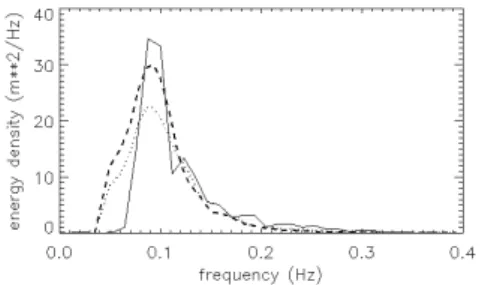
First, the KuROS data set is used in conjunction with numerical wave model outputs and buoy observations to assess the performances on mean (significant wave height, peak
Magenta open circles, green dots and red curve represent the results inverted by fitting GO4 to PR data under conditions of dominant swell, pure wind waves and all cases with
