HAL Id: tel-01982358
https://tel.archives-ouvertes.fr/tel-01982358
Submitted on 15 Jan 2019Conduite du bétail et coexistence entre les aires
protégées et leurs périphéries : une approche
participative
Arthur Perrotton
To cite this version:
Arthur Perrotton. Conduite du bétail et coexistence entre les aires protégées et leurs périphéries : une approche participative. Sciences agricoles. Université Montpellier, 2015. Français. �NNT : 2015MONTS118�. �tel-01982358�
0122544
Délivré par l’Université de Montpellier
Préparée au sein de l’école doctorale GAIA
et du Centre de Coopération International de
Recherche Agronomique pour le
Développement
Spécialité :
Écologie, Evolution, Ressources Génétiques,
Paléobiologie
Présentée par Arthur Perrotton
Soutenue le 17 Décembre 2015 devant le jury composé de
Mr Doyle McKEY, PR, Université Montpellier, CEFE Directeur de Thèse
Mr Michel de GARINE-WICHATITSKY, DR, CIRAD Co-Directeur de Thèse Mr Serge BAHUCHET, PR, MNHN Rapporteur
Mme Juliette ROUCHIER, DR, LAMSAD (Paris-Dauphine) Rapporteur Mr William McCONNELL, Michigan State University Examinateur
Mr Raphaël MATHEVET, DR, CNRS Examinateur
Conduite du bétail et coexistence entre les aires
protégées et leurs périphéries :
Une approche participative
Cattle Herding and coexistence between protected
areas and their peripheries:
A mon grand-père,
Avant-Propos / Foreword
Cette thèse a été effectuée dans le cadre du projet SAVARID1 financé par l’Agence Nationale de la Recherche (ANR) et la plateforme de recherche “Produire et Conserver en Partenariat ” (RP-PCP) qui associe au Zimbabwe le CIRAD, le CNRS, l’Université du Zimbabwe (UZ, Harare) et l’Université Nationale des Sciences et Technologies (NUST, Bulawayo). Durant les deux années de travail de terrain, nous avons eu l’honneur d’être affilié au Centre de Science Sociales Appliquées de l’Université du Zimbabwe (CASS). La conduite de ce travail a également été rendue possible par le projet HERD (Hwange Environmental Research Development) et des chercheurs du CIRAD, du CNRS et de différentes universités européennes qui ont étudié les dynamiques écologiques dans et autour du Parc National de Hwange depuis plus de dix ans. Afin de faciliter la restitution aux partenaires locaux, ce manuscrit a été rédigé en anglais.
This PhD was conducted under the SAVARID project2 funded by the French National Research Agency (ANR), and the research platform “Produce and Conserve in Partnership” (RP-PCP) that involved the CIRAD, the CNRS, the University of Zimbabwe (UZ, Harare) and the National University of Science and Technology (NUST, Bulawayo). During the two years spent in Zimbabwe for fieldwork, we had the honor of being affiliated to the Center for Applied Social Sciences of the University of Harare (CASS). We also beneficiated from the support of the HERD project (Hwange Environmental Research Development) and of the researchers from CNRS, CIRAD and several European universities that have been working for more than a decade with the objective of better understanding ecological dynamics in and around Hwange National Park. In order to ease the restitution of this work to Zimbabwean partners, this PhD thesis is written in English.
1 http://www.agence-nationale-recherche.fr/suivi-bilan/editions-2013-et-anterieures/environnement-et-
ressources-biologiques/societes-et-changements-environnementaux/fiche-projet-cep-s/?tx_lwmsuivibilan_pi2[CODE]=ANR-11-CEPL-0003 2
Preamble
"En route, le mieux c'est de se perdre. Lorsqu'on s'égare, les projets font place aux surprises et c'est alors, mais alors seulement, que le voyage commence."
Nicolas Bouvier
This PhD is the result of more than a three years long contract. Like most of my colleagues, I’ve always been interested by the nature surrounding me. The obsession about Africa came late and my first step on this continent, in 2010, changed my vision of human-nature relationships. Doing an “environment, farming and development” Master degree, I went for a 6 months long attachment with CIRAD, and conducted an impact assessment of a development project aiming at providing legal bush meat to rural communities living on the edge of a private conservancy in eastern Zimbabwe. Over the course of my fieldwork I spent several weeks pitching my tent in schools’ yards and interviewed villagers. The young adult that I was saw for the first time what was “behind” conservation. I realized how rural communities were absent of public conservation discourses in western country. Back in France, I knew two things. First I knew that I wanted to continue this academic cursus and do a PhD. I also knew that the interactions between conservation areas and their peripheries was the field I wanted to investigate. I applied for a second master degree, this time in anthropology at the French National Museum of Natural History because I felt I needed social sciences skills to achieve my objectives. I went back to Zimbabwe for an attachment, and obtained the trust of researchers who proposed me to do this PhD. The quote given on top of this preamble summarizes the past years of my existence: I started, got lost and wandered quite a lot. I was lucky enough to be supervised by the good people, thanks to whom this journey was possible.
Remerciements
I spent most of the last five years of my life either in Zimbabwe or in France…writing about Zimbabwe. Five years of work, including three for this PhD, but also five years of the purest form of happiness. Many are those to be thanked for it, and I will do my best not to forget anyone. This PhD thesis is written in English, but the acknowledgements will include a bit more diversity and adopt the language of people I needed to thank for having allowed me to go through this fantastic adventure.
A mes encadrants…
Du fond du cœur je tiens à remercier Michel de Garine-Wichatitsky, Christophe Le Page et Doyle McKey. Merci de m’avoir fait confiance, merci de m’avoir encadré scientifiquement et encouragé à pousser toujours plus loin ma réflexion. Merci de m’avoir initié à la modélisation d’accompagnement, une approche qui restera au cœur de mes travaux futurs. Merci aussi de m’avoir mis la pression quand j’en avais besoin et recentré quand je m’égarais…ce qui est arrivé souvent. Votre soutient est allé au-delà de l’encadrement scientifique et je vous remercie donc aussi d’avoir été là pour moi quand j’avais besoin d’aide, qu’elle soit logistique, économique parfois, ou émotionnelle. Cela a été un grand plaisir de découvrir le monde de la recherche à vos côtés, et j’espère que nous continuerons à travailler ensemble.
Ensuite, je tiens à remercier Aurélie Binot et Sébastien Le Bel. Vous m’avez il y a cinq ans ouvert les portes du CIRAD et permit de mettre mon premier pied au Zimbabwe. Mon profond amour du Zimbabwe est né à cette occasion, tout comme mon intérêt pour les problématiques liées aux interactions entre aires protégées et communautés rurales.
Au membres dujury…
Merci à Serge Bahuchet et Juliette Rouchier d’avoir accepté d’évaluer ce travail, et à William McConnell et Raphael Mathevet d’avoir accepté de se joindre au jury de soutenance. Ces remerciements ont été écris après la soutenance, et je tiens donc à tous vous remercier pour ce moment de partage dont je garde un très bon souvenir.
To the academic and local partners…
I want to thank the academic and institutional partners without whom this work could not have been done. I want to thank all the researchers from the research platform “produce and conserve in partnership” (RP-PCP) in Zimbabwe. I particularly want to thank the Center for Applied Social Sciences and particularly Dr Billy Mukamuri for his support, his knowledge about rural communities and advice. This PhD took me in and out of Hwange National park and Sikumi Forest, I express my gratitude these institutions and to their local representatives. I am deeply grateful to Tendai Selima (Sikumi Forest Manager), Mr Jura (Main Camp Area Manager), Edwin Makuwe and Lovelater Sebele (Main Camp ecologists), and all the other members of the Main Camp team, Simeon, Juliet,Bloomer, Philani, Owen Mangwana and those I forget!
A mes collègues…
Un immense merci à tous les collègues du CIRAD et du CNRS et leurs familles, compagnons de route au Zimbabwe avec qui j’ai travaillé, discuté et collaboré. La liste est longue et ne répond à aucun ordre particulier. Merci à Alex et Carole Caron, Sophie de Garine, Laure Guérini et Constant, Daniel Cornelis, Mathieu Bourgarel et Marion StGéry. Partager ce moment de vie au Zimbabwe a été fantastique. Merci pour l’aide scientifique et les coups de main du quotidien. Merci de m’avoir aussi ouvert les portes de vos foyers quand je daignais sortir de ma « brousse » pour aller retrouver la capitale. Merci d’avoir sorti la tête du « chti pèpère » de l’eau quand il se noyait. Un immense merci à Hervé Fritz, incarnation de la joie de vivre qui sait partager avec les autres son amour de Hwange et des autres. Merci à Chloé Guerbois et Eve Miguel de m’avoir ouvert les portes des communautés
Marie-Anne Dutour, MAP (phacochère), Natalie Rovis, Marie-Noël de-Visscher, Gilles Balança, Johan Michaux, Nicolas Gaidet, Marie Gely, Vladimir Grosbois, Jean-Charles Sicard, Daouda Kassie, Véronique Chevalier, Martine Antona, François Bousquet et Aurélie Botta. C’est aussi un peu grâce à vous tous que j’ai le bout du tunnel. Merci pour votre soutient et votre bonne humeur. Merci à mes co-thèsardes, compagnes de galère, d’insomnies et de lundis difficiles ! Merci à Clémentine et Marie-Marie, duo de choc du premier étage et à Hermine et Camille !
A Hugo Valls, a.k.a. Fox, a.k.a. Foxy, mon frère du Bush, un immense merci. Une amitié réelle est née dans à l’Ouest du Zimbabwe. On s’est soutenu, engueulé, aidé, et c’est vrai qu’heureusement qu’on était deux par moments, surtout vers la fin… Merci pour ce footing à 22h30 ce soir d’Octobre, je pense qu’on n’aurait bouclé sans ça ! Nos routes sont lié maintenant, et vivement le prochain projet ensemble.
To all my friends in Zimbabwe…
Brent, Laurie and Pork chop (the beautiful sunshine family), Rodney, Tash, Nirvana and Tatum, Marleen, Brian, Tendeka and Khaya. We started as neighbors and I am proud to now count you as my friends. Thanks for everything, especially for the braiis and other crazy nights spend in Saf ’Lodge, Sable Sands or Mabale…It’s funny what a sunset drink and a frozen chicken can lead to. My experience of Zimbabwe wouldn’t be the same without you all. Siyabonga/twalumba to Zakhele Mpala, Martin Muzamba, my Safari Lodge colleagues. I don’t really think I could have survived Hwange without you too…seriously. I want to thank all the Zimbabwean students met in Hwange, Cynthia, Nobuhle, Gugulethu, Buhle, Vuyo and Peace, who taught me as much as I taught them.
To rural communities…
This work was made possible by the support of Honorable chief Nelukoba, and Headman Victor Bitu. I sincerely thank them from the bottom of My heart. To Headman Bitu and his familly, thanks for allowing me to share your life for all these weeks. Bary, Frazer, thank you for all these days walking in the villages and introducing my to local cultures…Taboka !!
A huge thank you to all the Kulayinjana team: Victor, Cephus, Ambu, Fumbane, Ferdinand, Raphael, MaNdlovu, Zenzo, Patrick and Killion. Thank you all for spending all this time with us, sharing our knowledge, our ideas and visions of the world. There are no words to express my gratitude. Working with you was a real pleasure. I slowly realize how this experience changed me. Thanks to you I know how I want to make science. I think we can be proud of ourselves my friends! I don’t know how, or when, but our roads will meet again.
A ceux que j’aime…
Peace, ngiyabonga sithandwa. Things are quite simple to say : Ngiyabonga for being you. You have no idea how much your presence helped me. Ngiyakuthanda ngeyenhlisio yami yonke.
Merci à mes parents de m’avoir donné le gout du voyage, merci d’avoir laissé trainer les romans de Blaise Cendrars ou de Raphael confiant. Merci d’être des parents géniaux. Merci de m’avoir assis petit dans un avion et de m’avoir montré que le monde est grand, qu’il est beau, qu’il est plein d’odeurs et de saveurs, d’hommes et de femme. Merci d’avoir soufflé dans mes voiles pour m’encourager à aller le voir encore et encore. J’ai souvent été loin de vous ces cinq dernières années et comme tous les parents je sais que ça a été dur pour vous parfois. Merci d’être venu me voir, d’avoir partagé ma vie le temps d’un voyage. Si je suis là où je suis, heureux jour après jour, c’est beaucoup grâce à vous.
Abbreviations
A: Actor (SES Framework) ABM: Agent-Based Model AM: Adaptive ManagementANR: Agence Nationale de la Recherche (French National Research Agency) BSAC: British South African Company
CAMPFIRE: Community Area Management Program For Indigenous Resources CBRNM: Community Based Natural Resources Management
CIRAD: French International Cooperation Center for Agronomic Research and Development ComMod: Companion Modeling
CORMAS: Common-pool Resources and Multi-Agent Systems DMP: Decision Making Process
ENSO: El Niño Southern Oscillation FAO: Food and Agriculture Organization
GL-TFCA: Great Limpopo Transfrontier Conservation Area GS: Governance System (SES Framework)
HNP: Hwange National Park I: Interactions (SES Framework)
IUCN: International Union for the Conservation of Nature IDOZM: Indian Ocean Dipole/Zonal Mode
KAZA-TFCA: Kavango Zambezi Transfrontier Conservation Area LKS: Local Knowledge System
MAB: Man and Biosphere MAS: Multi-Agent System Nb: Nambya
NPWLMA: National Parks and Wildlife Management Authority O: Outcomes (SES Framework)
ODD: Overview, Design, Details (Standardized framework to describe Agent-Based Models) PA: Protected Area
PAC: Problem Animal Control PNS: Post-Normal Science RDC: Rural District Council RPG: Role-Playing Game
RS: Resource System (SES Framework) RU: Resource Unit (SES Framework) SF: Sikumi Forest
SES: Social-Ecological System
TFCA: Transfrontier Conservation Area UNEP: United Nations Environment Program
UNESCO: United Nations Educational, Scientific and cultural Organization UNDP: United Nations Development Program
V0: Launch Version V1: Version 1 V2: Version 2 VF: Final Version
Table of contents
Avant-Propos / Foreword _____________________________________________________ i Preamble __________________________________________________________________ ii Remerciements ____________________________________________________________ iii Abbreviations _____________________________________________________________ vii Table of contents ___________________________________________________________ ix List of Figures, Tables, Boxes and Pictures ______________________________________ xiiCHAPTER 1. General Introduction ___________________________________________ 1
Social-ecological systems, an alternative vision of societies and their environment ... 2
An overview of social-ecological issues within SESs ... 4
Protected areas and their peripheries: examples of land-use conflicts ... 6
Our research project: questions, objectives and organization of the manuscript ... 11
CHAPTER 2. Context and Theoretical frameworks _____________________________ 13 WHAT IS THIS CHAPTER ABOUT? ... 14
Study site ... 15
A brief pre-colonial history of human populations in the area ... 17
The colonial era: evictions, resettlements and wildlife conservation ... 19
Cattle herding at the heart of coexistence between rural communities and the Sikumi Forest... 23
Theoretical framework and methodological approach ... 26
Theoretical approach ... 27
Wicked problems, a major challenge in social-ecological research and management ... 27
“Post-normal science”, addressing wicked problems through interdisciplinary and participatory approaches ... 29
Our vision of interdisciplinarity ... 32
From theories to practice ... 33
Companion Modeling ... 33
Agent-Based Models, Role Playing Games and situated knowledge ... 35
CHAPTER 3. Ethnographical fieldwork: Exploring rural livelihoods and local knowledge ________________________________________________________________ 37 WHAT IS THIS CHAPTER ABOUT? ... 38
Introduction: exploring local knowledge and practices ... 39
Methods: an ethno-ecological approach ... 40
The fields, the cows and the forest: a holistic approach to rural livelihoods at the edge of a protected area ... 42
Food production: farming in a semi-arid area... 42
Agriculture, wealth and social networks, insights into the multiple dimensions of cattle in the study area 45 Reading the environment: dynamics of the ethno-meteorological knowledge system of a multicultural community farming in a semi-arid area of Zimbabwe ... 48
Abstract : ... 48
Introduction ... 49
Methods ... 51
Context of research ... 53
A multicultural and plurilinguistic community ... 53
Communal land in Hwange district: farming in unproductive drought-prone areas ... 55
Nambya and Ndebele meteorological knowledge ... 57
Local rain classifications ... 57
Ethno-meteorological indicators and forecasts: From individual observation to collective forecasts and knowledge sharing ... 58
Conclusion: creating knowledge ... 65
CHAPTER 4. The Co-design of the Role Playing Game __________________________ 68 WHAT IS THIS CHAPTER ABOUT? ... 69
“Teaching each other’”: A Co-designed research tool to elicit cattle herding strategies at the interface between a protected area and rural communities in Zimbabwe ... 70
Abstract: ... 70
Introduction ... 71
Methods ... 73
Study Area ... 73
Implementing a ComMod approach to understand cattle herding strategies ... 75
Evaluating the co-design process and the final game ... 82
Results ... 84
Initiating and achieving a “fair” team work ... 84
A collective effort towards consensus ... 84
From “Farming to be rich” to “Teaching each other”: appropriation of the game and emergence of endogenous objectives ... 84
Model vs Reality: a validation of the game by naïve individuals ... 86
Local strategies gathered through playing Kulayinjana ... 88
Exploring the potential alternative uses of Kulayinjana ... 89
Discussion ... 89
Achieving participation and appropriation ... 89
The added values of a role playing game ... 90
The emergence of new objectives and the social responsibility of projects facilitators ... 91
Towards a formalization of research tools co-design ... 92
Process overview and scheduling ... 101
Design Concepts ... 103
Implementation details ... 104
Initialization of the simulation... 104
Input data ... 105
Details for crop sub-model ... 106
Details for elephant damages ... 107
Details for cattle damages ... 108
Details for cattle status dynamics ... 109
Details for cattle predation by lion... 109
Details for forage level in grazing areas and water levels in water pans ... 110
Choice, design and parametrization of the sub-models ... 112
Playing sessions: preliminary results and perspectives ... 113
Fields management: ... 117
Cattle herding: ... 119
Toward the characterization of herding strategies: ... 126
Defining the variables ... 126
Preliminary results and perspectives of autonomous simulations ... 129
Perspectives ... 134
CHAPTER 6. General Discussion ___________________________________________ 137 WHAT IS THIS CHAPTER ABOUT? ... 138
A relevant approach to study wicked problems and model complex decision making processes ... 139
Virtual worlds: getting out of the “catch-22” ... 139
Co-designing a context-based research tool: strategical negotiation of uncertainties ... 141
“Did you really need the game to model how people live?” ... 144
A tool for researchers…and local actors ... 147
Perspectives for Transfrontier Conservation Areas ... 149 General conclusion ________________________________________________________ 156 Literature Cited ___________________________________________________________ 158
List of Figures, Tables, Boxes and Pictures
Figures
Figure 1.1. The Revised social-ecological system (SES) framework
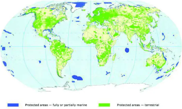
Figure 1.2. Overview of the protected areas as included in the World Database on Protected Areas Figure 1.3. TFCAs in southern Africa
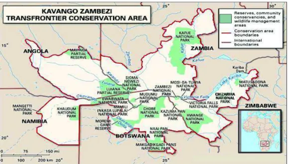
Figure 1.4. Map showing the five southern African countries covered by the Kavango-Zambezi TFCA: Botswana, Namibia, Angola, Zambia and Zimbabwe
Figure 2.1. Map of the study area showing the interface between villages studied and the two adjacent PAs: Hwange National Park and Sikumi Forest, Zimbabwe
Figure 2.2. Rainfall patterns in the study area
Figure 2.3. Estimated number of elephants (± SE) in HNP between 1980 and 2001
Figure 2.4. Simulated cattle movements in and out of the Sikumi Forest
Figure 2.5. Post-Normal Science diagram
Figure 2.6. The Role Playing Game co-design process
Figure 3.1. A few typical dishes
Figure 3.2. Map of cattle-herding roads in the Sikumi Forest drawn by a local herder
Figure 3.3. Study area
Figure 4.1. Study Area, villages adjacent to Hwange National Park and Sikumi Forest, Zimbawe
Figure 4.2. The Role Playing Game co-design process
Figure 4.3. Description of the launch version of the role-playing-game (V0): virtual environment, game setting and rain calendar
Figure 5.3. Sequential mobilization of the sub-models during the playing session
Figure 5.4. Interface used by the computer operator to enter players’ decisions every beginning of month. Figure 5.5. The weekly rainfall calendar
Figure 5.6. The virtual environment at the initiation of the model/playing session
Figure 5.7. Weekly rainfall data
Figure 5.8. Crops transition diagrams.
Figure 5.9. Elephants’ damages.
Figure 5.10. Cattle entering a Field
Figure 5.11. A representation of the tabulated function controlling the forage level of grazing areas and the size of water pans for the “Good Rain” year.
Figure 5.12. A representation of the tabulated function controlling the forage level of grazing areas and the size of water pans for the “Bad Rain” year.
Figure 5.13. Setting of the playing sessions.
Figure 5.14. Compared evolutions of the virtual environment in the three playing sessions (year 1 only). Figure 5.15. Crops management
Figure 5.16. Number of fields and type of crops planted per round
Figure 5.17. Management of crops residues.
Figure 5.18. Distance to the boundary in function of the distance to the kraal.
Figure 5.19. Two representations of the repartition of cattle grazing in the virtual environment
Figure 5.20. Grazing in the communal land despite growing crops. Figure 5.21. Simultaneous use of grazing areas according to the season.
Figure 5.22. Evolution of cattle herds body condition throughout the year
Figure 5.23. Grazing areas used depending on the season.
Figure 5.24. Projections of grazing areas used by players
Figure 5.25. Grazing areas chosen according to the rounds of play
Figure 6.1. Local responses, constraints and opportunities in Transfrontier Conservation Areas
Figure 6.2. Adaptive management
Boxes
Box 3.1. Sets of seasonal indicators and their link with agricultural calendars
Box 3.2. Examples of individual observations shared to anticipate the rains during the rainy season
Tables
Table 3.1. A sample of Food crops in the study area
Table 3.2. Examples of three seasonal calendars described by local informants living in the study area
Table 3.3. Local rain classifications expressed by Nambya and Ndebele villagers
Table 3.4. Ethno-meteorological indicators of the arrival of the rainy season
Table 3.5. Daily indicators used to predict imminent rains during the rainy season
Table 5.1. Model parameters
Table 5.2. Predefined timing for cattle predation by lion
Table 5.3. Variables identified and used to analyze playing sessions
Table 5.4. Cattle “leaving” and “entering” the game
Pictures
Picture 2.1. A rural homestead at dawn, Magoli
Picture 2.2. Elephants (Loxodonta africana) and a giraffe (Giraffa camelopardalis) drinking in a pumped water pan (Guvalala) inside Hwange National Park during the dry season
Picture 2.3. A road sign warning about the risk of elephants encounters
Picture 2.4. The cattle and the forest
Picture 5.1. The facilitator describing the playing board before starting the game in Magoli Picture 5.2. Players grouping their cattle in the forest during the month of December
Chapter 1 – General introduction
Social-ecological systems, an alternative vision of societies and
their environment
irectly linked with the social-ecological perspective (Emery and Trist 1965), several analytical frameworks aiming at studying the interaction between social and ecological systems emerged during the last decades (Binder et al. 2013). The Social-Ecological System (SES) framework originally emerged from ecological research at the end of the 1990s (Berkes et al. 1998). The argument from which the notion of SESs was developed is that of an historical and misleading separation of the two components (social vs. ecological) of what is in reality a single interconnected system (Bruckmeier, 2011). A brief overview of the literature provides various definitions of SESs and approaches to the concept. For Glaeser et al. (2007 p. 190) “A SES consists of a bio-geo-physical unit and its associated social actors and institutions
… SESs are complex, adaptive and delimited by spatial and functional boundaries surrounding particular ecosystems”. For Ostrom (2009), “SESs are composed of multiple subsystems … such as resource system, resource units, users, and governance systems, [which are] relatively separable but interact to produce outcomes at the SES level”. For Collins et al. (Collins et al.
2011 p. 351), “the conceptual scope of ecology must expand to embrace not only other scientific
disciplines, but also the pervasive human dimension of environmental structure and change … Every ecosystem on earth is influenced by human actions … the environment is best understood and studied as a socio-ecological system”. Relatively close to the SES framework is the
Coupled Human and Natural System (CHANS) approach (Alberti et al. 2011, McConnell et al. 2011) that acknowledges that “human and natural systems are coupled via reciprocal
interactions, understood as flows (e.g., of material, energy, and information). Of particular interest in studying these interactions is the understanding of feedbacks, surprises, nonlinearities, thresholds, time lags, legacy effects, path dependence and emergence) across multiple spatial, temporal and organizational scales” (McConnell et al. 2011 p. 219).
Chapter 1 – General introduction
According to the latest work on the theme (McGinnis and Ostrom 2014), a SES (Fig. 1) can be seen as one or more resource systems (‘RS’, e.g. a forest) composed of resource units (‘RU’, e.g. trees) that are used and produced by actors (‘A’, e.g. park rangers, farmers, tourists) whose actions are framed by governance systems (‘GS’, e.g. laws, institutions, traditional authorities). These elements, called first-tier variables (Ostrom 2009, McGinnis and Ostrom 2014), are the highest-level components of the SESs, that is the fundamental bricks of the system. They “relatively separable but interacting to produce outcomes at the SES level”. Indeed, beyond these logical linkages, the SES framework assumes a set of feedback loops between the first-tier variables, either directly or through the interactions (‘I’) and outcomes (‘O’).
Figure 1.4. The Revised social-ecological system (SES) framework (extracted from McGinnis and Ostrom 2014).
Interactions take place in focal action situations, and among them are conflicts, harvesting, information sharing, lobbying activities, monitoring activities or investment. The outcomes resulting from interactions between the first-tier variables highlighted by Ostrom and McGinnis (2014) fall under three categories: social performances, ecological performance and externalities to other SESs. Indeed, joining Gunderson and Holling’s concept of panarchy (Gunderson and Holling 2002), a fundamental property of a SES is that its boundaries only exist for analytical reasons, whereas in fact, social-ecological dynamics are influenced by and have influence on “external” social-ecological systems.
Chapter 1 – General introduction
An overview of social-ecological issues within SESs
When opening the “Actors” box (Fig. 1) of a given SES, one will come to consider a potentially high diversity of local actors/groups of actors, sometimes also called stakeholders in this thesis. Taking the simple example of a river, Webber (1998) explains how the fisherman’s, the engineer’s, the geographer’s and the ecologist’s river are different, although they are based on the same environmental feature. Power games between actors (Barnaud and Van Paassen 2013), interactions between land uses (Chitakira et al. 2015), co-operation or its opposite (tensions and conflicts) will impact the functioning of the SES (Tompkins and Adger 2004, Wehrmann 2008).
This plurality of stakeholders interacting around common resources therefore brings with it the question of coexistence, for which the Collins dictionary3 provides us with two definitions: (i) the situation of existing together at the same place and at the same time, or (ii) to exist together in peace. Coexistence is more than the sum of interactions and outcomes, and is a key driver of SESs (Guerbois et al. 2013). In cases where the coexistence of different land use results in reciprocal benefits, we can expect local actors to collaborate to maintain these benefits. But when one or more actors dominate and achieve their own objectives at the expense of others, we can expect the emergence of conflicts, along with an increase in individualism and rule avoiding mechanisms that can in fine threaten the system as a whole.
A conflict is a “difference within a person or between two or more people (or groups of people) that touches them in a significant way” (LeBaron and Pillay 2006; p. 12). A conflict is characterized by five phases: initiation, escalation, controlled maintenance, de-scalation and some kind of termination (Cheldelin et al. 2003). Conflicts can take many forms, and produce more or less violent outcomes. Tensions and conflicts can happen at different scales, from local employee/employer conflicts within companies4, to larger societal conflicts where part of the
Chapter 1 – General introduction
growing opposition to the use of nuclear power (Hartmann et al. 2013). Social conflicts are part of societal dynamics and are usually solved before reaching overtly violent manifestations. At the end of the Cold War, ethno-political conflicts excontinued a trend that began in the decolonization processes of the1960s (Harff and Gurr 2004) and often reached the most violent forms of conflict: genocide and war.
As shown in the previous examples, the natural environment often plays a major role in conflicts (Libiszewski 1992). Natural resources have always been the object of contention and sometimes violent conflict between different social groups and between states (Westing 1986). On a large scale with the previous example of the opposition to nuclear power, or the recent media frenzy about Cecil the lion, who was shot by a trophy hunter in the periphery of Hwange National Park in Zimbabwe5, environmental conflict can transcend SESs and take place around conflictive values and ideologies about human/nature relationships and occur between people who do not directly interact with each other. On a local scale, coexistence issues often rely on the interactions between groups of actors and their respective use of the land. A land use is defined by the United Nations Food and Agriculture Organization (FAO) and the United Nations Environment Program (UNEP) as the “arrangements, activities and inputs people undertake in a certain land cover type to produce, change or maintain it”. Using LeBaron and Pillay’s (1996) definition of a conflict, a land use conflict is a situation where the land uses and related practices of two or more people (or groups of people) produce outcomes that touch them (negatively) in a significant way. SESs are complex systems with strong feedback loops, and land use conflicts have extensive negative effects on economic, social and ecological development of SESs as whole entities (Wehrmann 2008).
5
Chapter 1 – General introduction
Protected areas and their peripheries: examples of land-use
conflicts
According to the International Union for the Conservation of Nature (IUCN) Red list published in 2012, 22% of the earth’s vertebrate species, 41% of invertebrates and 70% of plants were threatened at that time. Thus, more than one species in five on the globe was threatened by extinction, and the list is only getting longer (Hoffman et al. 2010). The extent to which human activities have impacted the environment has taken the Earth to what some authors consider to be the sixth mass extinction crisis (Barnosky 2011). Protecting and conserving the environment is crucial to the survival of humanity (e.g. Sukhdev et al. 2010). Nevertheless, conservation activities are not undertaken without raising questions about the human/nature relationship promoted, and about international power games at stake and their local consequences. As our work is focused on tensions and conflictive relationships between actors at the edge of a Protected Area (PA), a short analysis of conservation, its, ideological roots and social effects is necessary at this point. The last part of this section will give examples of social-ecological issues affecting spaces in and around protected areas, with a particular focus on eastern and southern Africa.
PAs are the most widely known strategy for conserving biodiversity in the face of ecosystem degradation (Palomo et al. 2014). The IUCN defines a PA as “a clearly defined geographical space, recognized, dedicated and managed, through legal or other effective means, to achieve the long-term conservation of nature with associated ecosystem services and cultural values” (Dudley 2013). This definition is refined by six categories depending on the management objectives and conditions: from exclusives nature reserves (Ia) and wilderness areas (Ib), where human visitation is prohibited or controlled and limited to ensure protection of conservation values and to maintain “natural” conditions, to PAs allowing sustainable use of natural resources6 (VI), which conserve ecosystems while maintaining the exploitation of the
Chapter 1 – General introduction
by at least 50% since 19968 (West et al. 2006). Although this increase is partly due to an improved recording of already existing PAs, the fact remains that since the 19th century and the creation of the iconic Yosemite National Park in the USA, the total surface of PAs increased to reach a total of 209,429 PAs recorded in 2014, a total area of 32.106 km², an area larger than the continent of Africa. Excluding Antarctica, 15.4% of the world’s terrestrial area is in some kind of protected status (Fig. 1.2).
In a globalized world, PAs have become the means by which people see, understand, experience and use parts of the world that are often called “nature” and “environment” (West et al. 2006). They are cultural artifacts, a virtualizing vision (Carrier and Miller 1998, West and Carrier 2004) imposing the European nature/culture dichotomy9 on places and people where this distinction did not previously exist. PAs imposed themselves as an imperialist cosmology of nature, defined what is just, moral and right in terms of environmental management and as such, can be seen as the material and discursive means by which conservation and development discourses, practices and institutions remake the world (Brosius 1999). There is more to PAs than just the IUCN’s definition. They are physical projections of the western division between nature and culture, and through their implementation and the process of their classification, they participate in a generification of the external world (West and Carrier 2004). As expressed in the Durban Action Plan produced after the fifth World Park Congress (2003), there are connections between dispossession and poverty, culture change and social subsistence losses on the part of people living around protected areas (MacKay and Carison 2004). Although the philosophy of conservation is slowly changing (Dudley et al. 2014), and the social-ecological framework is partly adopted in PA management (Palomo et al. 2014) with the integration of concepts such as complementarity of landscapes (e.g. Chitakira et al. 2015), the historical implementations of PAs and their consequences are still apparent (Neumann 2001). The meeting and interactions of wildlife conservation on one side and farming and cattle herding on the other on make the edges of African PAs often conflictive. Taking the example of the Maasai Mara National Reserve in southwestern Kenya, Butt (2012, 2014) showed how the Maasai herders were marginalized despite the fundamental role of their practices in the production and maintenance of landscapes in which wildlife thrives.
8
Other protection designations exist, such as RAMSAR sites (RAMSAR Convention), the United Nations Education and Science Organization (UNESCO) World Heritage Sites or Man and Biosphere program (MAB) sites. These do not always fit in the categories previously cited (Dudley 2013).
Chapter 1 – General introduction
Figure 1.5. Overview of the protected areas as included in the World Database on Protected Areas (http://www.unep-wcmc.org/resources-and-data)
The three transformational moments identified by the author as leading to regular conflicts between pastoralists and PA managers are (i) the creation of safaris as a distinct commodity through which one can observe a wildlife-rich environment devoid of humans, (ii) the strategic spatial and temporal placement of National Parks officials to protect the safari experience within which tourists interact with local communities only during community-tours and therefore cannot really appreciate their practices, and (iii) the identity (re)creation where tourists and rangers regard herders as a threat to pristine wilderness, tourists see rangers as protectors, rangers identify herders as a threat to their identity of protectors and Maasai herders see rangers (who are Maasai too) as cattle raiders (Butt 2012). Conflictive interactions between PAs and surrounding populations are found in other places in eastern and southern Africa. Human-wildlife conflicts are omnipresent and mainly involve livestock, humans and carnivores
Chapter 1 – General introduction
Transfrontier Conservation Areas (TFCAs, Fig. 1.3) are defined in the Southern African Development Community (SADC) protocol on wildlife conservation andlaw enforcement as
“components of a large ecological region that straddles the boundary of two or more
countries, encompassing one or more protected areas as well as multiple resource use areas [e.g. communal farming land, mines, etc.] (…) founded with the aim of collaboratively managing shared natural and cultural resources across international boundaries for improved biodiversity conservation and economic development”10.
With the rise of TFCAs in southern Africa, many people who were often displaced in the formation of protected areas decades earlier now find themselves residing conservation area of this type (Andersson et al. 2013a). There are currently 13 TFCAs in southern Africa (Fig. 1.3), although not all are at the same point of development. Five of them include Zimbabwean protected areas, among which are the two largest ones: the Great Limpopo TFCA (GL-TFCA), and the Kavango-Zambezi TFCA in which we conducted our work.
Emblematic of TFCAs, the Kavango-Zambezi (KAZA-TFCA) was officially inaugurated in 2012. It sprawls over five countries (Fig. 1.4) and covers a total of 444 000 km², an area equivalent to Italy. Centered around the Okavango and Zambezi river basins, it encompasses 36 PAs, among which are more than a dozen National Parks (NPs), notably Hwange National Park (HNP) and the Sikumi Forest, at the edges of which our study area is located (Chapter 2).
10
Chapter 1 – General introduction
Figure 1.6. TFCAs in southern Africa (reproduced after Andersson et al 2013, chapter 2). The figure shows the
thirteen southern African TFCA: (1) Kavango-Zambezi (KAZA), (2) Niassa-Sealous, (3) Great Limpopo, (4) Kgalagadi, (5) Iona-Skeleton Coast, (6) Mana Pool-Lower Zambezi, (7) Drakensberg-Maloti, (8) Liuwa Plain, (9) Ai-Ais/Richtersveld, (10) Greater Mapungubwe, (11) Lebombo, (12) Nyika-Vwaza Marsh, (13) Kasungu-Lukusuzi. Not all these TFCAs are at the same point of development
.
By including protected and communal areas within gigantic international conservation-oriented areas, TFCAs offer particularly relevant contexts to study the coexistence of diverse
# # # # # # # # # # # # # # # # # # # # ## # # # #### # # # ### # # # ## ## # # ### # # # # ## # # ## # # # # # # # # ## # # # # # # # # # # # # # # # # ## # # # ## # # # # # ## # # # # # # # # # # # # # # # # # ## # # # # # # # # ##### # # # # ### # # # # # ### # # # ### # # # # # # # # # # # # # # # # # # ## # # # # # # # ## # # # # # # # # # # # # # ## # # ## #### # # # # # ## # ### ## # # # # # # # # # # ## # # # # # # # # # # # # # # # # # # ## # ##### # # # # # # # ## # # # # # ## # # ## # Po in t Lo c ation of Pa rk Con se rv anc y
Ga me /W ildlif e M an age me nt Are a, C out ada or Res e rv e Fores t Nation al P ark Lak e Nation al B oun da ry CBN RM Ke y N 200 0 200 KM
TFCAs in Southern Africa
TFCA 1 2 3 5 4 6 7 8 9 10 11 12 13
Chapter 1 – General introduction
Figure 1.4. Map showing the five southern African countries covered by the Kavango-Zambezi
TFCA: Botswana, Namibia, Angola, Zambia and Zimbabwe (www.britannica.com).
Our research project: questions, objectives and organization of
the manuscript
The previous paragraphs set the general context of our work. We described how the interactions between societies and their environment could be formalized to produce the SES framework. We do not argue that this framework is the only one to approach the matter, but we chose to adopt it as it allows the integration of several disciplines and therefore enhances dialogue between researchers and practitioners originating from different academic fields. We briefly gave a definition of what a conflict is and how conflicts emerge in SESs. We proposed our vision of protected areas and provided examples of actors and land-use conflicts shaping these.
Social-ecological problems are complex and in some cases wicked problems, that defy simple solutions (Balint 2011). Incomplete scientific knowledge, uncertainty, competing cultural values and the gap between the real matter as it appears to local stakeholders and the matter as it exists for exogenous researchers, make studying such problems quite challenging. Local stakeholders’ participation is one of the possible strategies allowing us to cope with this
Chapter 1 – General introduction
challenge. Conducted at the edge of a Zimbabwean PA, this PhD study focuses on a coexistence issue grounded in the interactions between farming and cattle herding activities on the one hand, wildlife conservation and timber production on the other hand. We focused our attention on cattle herding practices, which are at the heart of the interactions between the two land uses and the actors who conduct them. These rely on complex decision making processes, and we decided to put efforts in the co-design of a research tool that would allow us to elicit these strategies. This research tool took the form of a Role Playing Game (RPG) and was created by a team involving researchers and 10 members of the local communities. The RPG was later implemented with 4 sets of villagers leaving in the area. The manuscript is structured as follows: Chapter 2 will describe our study site and the interdisciplinary approach (ComMod) implemented during the past three years; chapter 3 will provide an ethnographical description of the production system of local communities, with a particular focus on local meteorological knowledge on which farmers rely in this semi-arid environment; Chapter 4 will describe the core of our activities, i.e. the co-design of a role-playing game aimed at eliciting and modeling cattle herding strategies; A general discussion and conclusion will be given in Chapter 5.
Chapter 2-Context and theoretical frameworks
WHAT IS THIS CHAPTER ABOUT?
T
his chapter introduces the reader to the context in which we conducted our research, and present the theoretical frameworks and methodological approach we adopted to achieve our objectives.The chapter is organized as follows:
· The first section gives a detailed description of our study area. This includes of course the geographic location and the general agro-ecological characteristics. Keeping the political-ecological approach developed in the first chapter, we put a particular emphasize on the description of the social and political history of the area. This covers the precolonial period, and explains the history of current ethno-linguistic groups living in our study site. The Rhodesian era (1889-1980) and the post-colonial period (since 1980) are described mostly in relation with the land-related policies that shaped the coexistence between rural communities and protected areas.
· The second section of the chapter describes the theoretical frameworks used during our work. As the detailed methods are given in their related chapters, we propose the reader the theories behind the methods. We describe how social ecological problems are wicked problems, and how addressing them needs to transcend the classical frames of science. We describe the notion of post-normal science and the role of participation and interdisciplinarity. The last part of this second sections how the former mentioned frameworks were put into practice, that is through companion modeling process and the use of role-playing games
Chapter 2 – Context and theoretical frameworks
Study site
his work was conducted within Ward 15 of the Hwange District, western Zimbabwe (Fig 2.1), at the interface between the villages of Magoli, Siyalwindi, Chezhou, Dingani and Jwape andtwo unfenced protected areas, namely Hwange National Park (HNP, 14651km²), a wildlife conservation area located a few kilometers to the southwest and the contiguous Sikumi Forest (SF, 11000 km²), a wildlife conservation and timber production area separated from the villages only by a tarred road. The study area can be qualified as semi-arid. Three seasons can be distinguished, a cold and dry season ranging broadly from May to August followed by a hot and dry season from September to October, and a rainy season from October to April, although the start of the rainy season varies greatly among years (Fig. 2.2). Annual rainfall ranges between 450 and 650 mm per year and is spatially highly heterogeneous (Chamaillé-Jammes et al. 2007). Severe droughts occur, as well as recurrent ‘dry spells’ during the rainy season (Fig. 2.2, Matarira and Jury 1992).
Figure 2.1. Map of the study area showing the interface between villages studied and the two adjacent PAs:
Hwange National Park and Sikumi Forest, Zimbabwe. Village boundaries are often contested and it is difficult to gain access to official records. The boundaries displayed on the figure were collected by Guerbois et al (2013).
Chapter 2 – Context and theoretical frameworks
Villages are restricted to the CA, that is an area dedicated to human settlements with lands allocated by traditional leaders (Guerbois et al. 2013), while HNP and SF are managed by their respective governmental authorities, the National Parks and Wildlife Management Authority (NPWLMA) and the Forestry Commission. As demonstrated in Chapter 1, coexistence issues between protected areas and neighboring communities are omnipresent throughout the African continent, among which are poaching (Rowcliffe et al. 2004), cattle incursions in protected areas (Butt 2014) and the lack of benefits derived for rural communities (Emerton 2001).
Chapter 2 – Context and theoretical frameworks
The interface between HNP, SF and rural populations is no exception and tensions exist between local stakeholders: human-wildlife conflicts (Metcalfe and Kepe 2008), poaching (Muboko et al. 2014), illegal wood harvesting, livestock predation by wild carnivores and crop raiding (e.g. Guerbois et al. 2012), along with disease transmission between domestic livestock and wildlife (de Garine-Wichatitsky et al. 2013). An important point is that although local demography is partly explained by the presence of protected areas, which attract people hoping to find a land of plenty (Guerbois et al. 2013), the positions of the studied villages themselves are mainly due to historical political violence; interactions between protected and communal areas were shaped by colonial and post-independence policies (Compagnon 2003, Ncube 2004, Mlambo and Raftopoulos 2009). To enable full understanding of the context of coexistence in the area, the description of the study site will follow three steps. Firstly, we will describe the pre-colonial history of human settlements in the area. With a focus on conservation, the second part will describe the colonial and modern history and its implications in terms of conservation policies and integration of communities in wildlife management and benefit sharing. The final part of the description of the study site focuses on the current interactions between rural communities of Ward 15 of Hwange District and will justify the consideration of cattle herding in our study.
A brief pre-colonial history of human populations in the area
Historical and anthropological literature on southern Africa is relatively scarce. The history of pre-colonial human settlements in our study area, although poorly described in published literature, is composed of several waves of migrations. The San people, hunter-gatherers and original inhabitants of southern Africa, left traces of their presence in Matabeleland north, the Zimbabwean province where our study was conducted (Cooke and Reese 1972) and are still living in the area (Mukamuri et al. 2013), although they are a minority. The first Bantu settlements in western Zimbabwe were located in the region of Victoria Falls (200 km from our study site) and belonged to the Kangila tradition, dating from between the 4th and the 5th century. The Tonga people descend from these early inhabitants and are still present in the Hwange District, although they are found more along the Zambezi River, both on the Zimbabwean and the Zambian sides. The name Tonga was probably given to them by other ethnolinguistic groups and means “chiefless”, people who do not recognize a paramount leader (Nyathi 2005). Other Bantu peoples migrated into the area and local traditional leaders
Chapter 2 – Context and theoretical frameworks
we met during our work confirmed that within Matabeleland, the Hwange district is the “Nambya area” (Ncube 2004, Mlambo and Raftopoulos 2009). The Nambya people (plural
baNambya), settled in the area in the beginning of the 18th century after breaking away from
the Rozvi empire. The name Hwange itself is derived from Wange, the dynastic title of Nambya rulers. The town of Hwange and Hwange National Park also took their names from it. There is still a chief Hwange ruling Hwange town and its surroundings nowadays. Several Nambya sacred places can be found in the district, such as Chigehari (about 30 km north of our study area) and the Mtoa and the Bumbusi ruins (both inside Hwange National Park), where Nambya ancestors’ bodies are buried. Livelihoods of the Nambya historically relied primarily on livestock husbandry, agriculture, and wild food harvesting (Ncube 2004, Nyathi 2005). The group most represented in the area today are the AmaTabele (sing. Ndebele). The Ndebele presence in the area started a few years when Mzilikazi Khumalo and about 500 of his men split apart from the Zulu Kingdom (in the northern part of South Africa) in 1821 during the mfecane period during which King Shaka created the militaristic Zulu kingdom (Laband 2011).
Chapter 2 – Context and theoretical frameworks
complex society(Lindgren 2004). The Ndebele kingdom no longer exists, but Bulawayo, its former capital, is now Zimbabwe’s second largest city, and two of the country’s provinces, namely Matabeleland North and Matabeleland South, are named after this kingdom.
The colonial era: evictions, resettlements and wildlife conservation
The colonial history of Zimbabwe, known at that time as Rhodesia, is characterized by two major trends, land appropriation by white settlers and the resulting resettlement of original populations, and the creation of large protected areas. Land appropriation by white settlers started in 1889 when the Rudd Concession was signed by the Ndebele King Lobengula and the
British South African Company (BSAC) of Cecil Rhodes (Parson 1993, Mazarire 2003, Ncube
2004, Nyathi 2005). White settlements started in 1890 and Rhodesia was officially established in 1895. Throughout the history of Rhodesia, racial discrimination had a considerable impact on access to land for black farmers by giving the best arable land to white Rhodesians (e.g. Mlambo and Raftopoulos 2009)11. In our study area, local rural communities were chased or relocated several times since the end of the 19th century, the first time in 1895 when Albert Giese took over 1036 km² around Bumbusi to exploit coal. Thirty years later, the Hwange district was shared between mining concessions (45%), inalienable land (50%), and a Nambya reserve (3%). In 1928 the Wankie (Hwange) Game Reserve and the Sikumi Forest were created on the previously inalienable land, and local communities were evicted from land in which they were either settled, driving their cattle or gathering natural resources such as fruits or firewood (Ncube 2004). To ensure the non-return of rural communities, some of the villages were burnt by the first Wankie warden, Ted Davison (DNPWLM 1999).
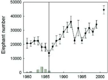
National Parks and tourism represent a substantial part (±15%) of the Zimbabwean economy (Peter Sai et al. 2015). HNP was created and managed to maintain wildlife in an area that was only used by wild animals and only during the rainy season. The main management tool was the development of a network of artificial water pans, which began in 1935 (DNPWLM 1999). Consequently, wildlife populations increased both within and outside the boundaries of the park. They actually increased so dramatically that the park’s managers were concerned by vegetation degradation and initiated culling programs in 1963 to control populations of wild herbivores, of which impalas (Aepyceros melampus), buffalos (Syncerus caffer) and elephants
11 This unfair allocation of arable land was partially addressed by the first land reform conducted under the Lancaster House Agreement (Compagnon 2003) by President Robert Mugabe in the early 1980s, and continued during the second land reform in the 2000s (Hanlon et al. 2012).
Chapter 2 – Context and theoretical frameworks
(Loxodonta africana) were the main targets (DNPWLM 1999). The elephant population in the HNP-SF ecological continuum and their periphery went from approximately 2000 individuals in 1928 to about 10 000 in 1963, when culling activities began. Due to underestimates of the elephant population, culling had little impact on population growth (Cumming 1981) and the population was estimated at around 21 668 in 1983. It was reduced to 13 000 in 1986 (De Garine-Wichatitsky et al. 2013). For economic reasons, and under international pressure, culling was stopped in 1987 and the elephant population has regularly increased (Fig. 2.3), with an average annual increase of 17% until 1992 and a population of about 35 000 individuals (Chamaillé-Jammes et al. 2008). The elephant population in and around HNP partly increased due to immigration from neighboring countries, justifying the concept of TFCAs.
The last elephant census initiative12 estimated that 54 000 individuals were living in the Hwange
area, accounting for 18% of the world population of African elephants.
Figure 2.3. Estimated number of elephants (± SE) in HNP between 1980 and 2001. Bars at the bottom of the
Chapter 2 – Context and theoretical frameworks
potential benefits of wildlife for rural development, and of the necessity to propose mechanisms compensating rural communities for the losses due to the presence of wildlife, Zimbabwe was among the first countries adopting integrated Community-Based Natural Resources Management (CBNRM) (Jones and Murphree 2001). In the early 1960s, the country’s wildlife policy radically shifted from a protectionist philosophy to one of conservation through sustainable use (Duffy 2000, Brosius 2006). This instrumentalist approach to wildlife issues (Brosius 2006) could be summarized by the statement, “proprietorship and the ability to earn direct benefits from wildlife provides more effective incentives for wildlife conservation”. The Park and Wildlife Act of 1975 transferred wildlife management to land owners, and three years later the Wildlife Industry New Development for All (WINDFALL) pushed this principle further, trying to entrust to rural communities the management of wildlife and to create local benefits taking the form of meat and of financial revenues derived from trophy hunting. Although the WINDFALL program failed, its conceptual roots remained and gave birth to the
Community Areas Management Program for Indigenous Resources (CAMPFIRE) in 1989,
which was implemented in our study area in 1992.
Picture 2.2. Elephants (Loxodonta africana) and a giraffe (Giraffa camelopardalis) drinking in a pumped water
pan (Guvalala) inside Hwange National Park during the dry season. (05/05/2012. A. Perrotton).
CAMPFIRE works as a decentralized institution, managed by Rural District Councils (RDC). The program relies on two main pillars, a sharing of trophy hunting revenues with local
Chapter 2 – Context and theoretical frameworks
communities, and the distribution of meat collected when wildlife causing damage in communal land (“problem animal control”, PAC; mainly elephants) is shot. Praised by some, criticized by others, more than 30 years after its beginning, the CAMPFIRE program has mixed and heterogeneous results across the country. In the Hwange district, the economic crisis of the 2000s (Compagnon 2001) and the consequential collapse of the tourism economy virtually put an end to the program. Villagers living on the edge of HNP and SF still suffer from crop raiding by elephants and livestock predation by wild carnivores, but do not really get any benefits anymore, except occasional meat from PACs. CAMPFIRE is fortunately not the only mechanism through which communities derive benefits from PAs. Indeed, protected areas provide natural resources such as non-timber products, but also poles and firewood and grazing for livestock. These natural resources are sometimes acquired through legal agreements between local actors, and often taken illegally.
Chapter 2 – Context and theoretical frameworks
Cattle herding at the heart of coexistence between rural communities and the
Sikumi Forest
Nowadays, local communities have no right of access for any use/extraction of natural resources from HNP except for occasional grass harvesting for thatching, under close supervision of rangers. Unlike HNP, the management of SF includes a direct use of natural resources (IUCN, cat.VI). The SF is made of several blocks, some dedicated to timber production, others leased to lodges for photographic safaris or trophy hunting. Neighboring communities have a controlled access to the forest and its natural resources. Women for instance, are allowed to collect firewood one day per week, only dead wood. Managers of the SF and traditional leaders collaborate in the management of pole harvesting. A villager who needs poles will write an official demand specifying the exact number of poles needed and have it stamped by the local traditional leader. This letter will be advised by a SF officer in Dete (Fig. 2.1) who will deliver an official authorization. As part of their veld fire prevention plan, the SF managers also involve local villagers in the harvesting of thatching grass (Hyparrhenia spp.). Although part of the grass collected is delivered to the Forestry commission, villagers get benefits as they can use and locally sell it. Furthermore, the severe droughts of the early 1990’s (Maphosa 1994) led the Forestry Commission and traditional leaders to negotiate a complementary right of access for neighboring communities. Herders obtained the right to graze their cattle within the SF (Guerbois et al. 2013), although the official authorized distance of incursion remains unclear and, depending on the informant, ranges from 2 km according to a Forestry manager to 3 km (Guerbois et al. 2013), and up to7 km according to local herders.
Previous studies conducted in the area confirmed the extensive use of the SF by local herders. The work conducted by Miguel et al. (2013) provides significant information. Figure 2.3 represents a simulation of cattle movements in the study area between December 2010 and August 2011 obtained by the deployment of 10 GPS collars. The reader will recognize the study area (Fig. 2.1), although two additional land uses are displayed, a residual inalienable state land between HNP and the communal area and a Marist Brothers’ concession (that is a land entrusted to a marist congregation by the local traditional authorities). These will not be mentioned in the rest of this thesis because we specifically focused on the SF/communal land interface. Even with this small sample (N = 10), the simulation shows the intense use of the forest by cattle owners living on the edge of the SF, and the central role of seasonal water pans, which, unlike those in HNP, are natural and do not benefit from (or depend upon) any pumping system.
Chapter 2 – Context and theoretical frameworks
Thirteen years after the agreement on this right of access, the forest’s land has become essential for livestock owners. Beyond the obvious benefits in terms of high-quality forage and water for their livestock, both resources being scarce in communal land, the use of the SF also represents a form of land claiming on a territory that was formerly used by the villagers a few decades ago. The right of access is a ‘bone of contention’ between traditional leaders and the forestry commission. On the one hand, villagers ask for an extended authorized distance of incursion into the forest, and on the other hand, forestry managers are concerned by the possible consequences of such an agreement: overgrazing to the detriment of wildlife, and an increase in opportunistic activities such as illegal wood harvesting or poaching.
Figure 2.4. Simulated cattle movements in and out of the Sikumi Forest. This simulation was obtained using the
CORMAS simulation platform (cf. chapter 3). Data used were obtained from GPS collars deployed on 10 individuals from 10 different homesteads (Miguel et al. 2013). The communal are (CA) is represented in yellow, the Sikumi Forest (SF) in light green, Hwange National Park (HNP) in dark green, a Marist Brothers’ concession (MB) in blue, the state land buffer(SL) between the Park and communal land in grey and the town of Dete (D) in white. The blue dots represent natural water pans. The red gradient (From white to dark red) represents the use of the landscape by collared cattle between (2010 and 2011) The darker red a cell is, the more extensively cattle used this portion of the landscape. The orange shape shows the surface of the SF used by cattle herders.
Chapter 2 – Context and theoretical frameworks
ecosystems, with low rainfall, recurrent droughts and dry spells and poor soils. The potential outcomes of our work could therefore be used in many other African SES characterized by coexistence issues between PAs and neighboring communities. Both land uses considered rely strongly on the environment, and influence the environment in return.
Picture 2.4. The cattle and the forest. Top: Cattle entering the Sikumi Forest (2013. Hugo Valls-Fox), Down:
Chapter 2 – Context and theoretical frameworks
Finally, as the literature cited shows, and as explained in further chapters, researchers have been present in the area for over a decade and have worked both with PA officers and rural communities, facilitating our integration into the local social network. The interactions between the SF and the local communities are diverse, some legally framed, some not. Although at first we considered studying coexistence as a whole, the knowledge gathered on the SES (social-ecological system) prior to our study, added to our own observations (cf. chapters 3 and 4), highlighted a particular activity, a “keystone” practice of interactions between the Sikumi Forest that merited focusing on: cattle herding. As the next section of this chapter will show, we focused our attention on eliciting cattle herding strategies by co-designing our own research tool with members of the local communities.
Theoretical framework and methodological approach
n the general introduction of this thesis (chapter 1), we described the SES framework that we have adopted. The second part of this chapter will not describe the specific methods used during our work, which will be detailed in their relative chapters, but rather the methodological approach adopted and the theoretical concepts we relied on. Land-use conflicts, like other social-ecological issues, can be seen as wicked problems, that are social problem in which the various stakeholders can barely agree on what the definition of the problem should be, let alone on what the solution is. To address the land-use conflict studied, we decided to transcend the classic frame of traditional science, and to adopt a post-normal posture (Funtowicz and Ravetz 1993), which was fundamentally interdisciplinary and participatory in a companion modeling process (ComMod) ((Etienne 2014). The main outcome of our work is a Role Playing Game (RPG) that was co-designed to elicit cattle herding strategies. This was done in several steps: (i) ethnographical fieldwork (cf. chapter 3), (ii) the iterative design of the