HAL Id: hal-00322617
https://hal.archives-ouvertes.fr/hal-00322617
Submitted on 18 Sep 2008
HAL is a multi-disciplinary open access archive for the deposit and dissemination of sci-entific research documents, whether they are pub-lished or not. The documents may come from teaching and research institutions in France or abroad, or from public or private research centers.
L’archive ouverte pluridisciplinaire HAL, est destinée au dépôt et à la diffusion de documents scientifiques de niveau recherche, publiés ou non, émanant des établissements d’enseignement et de recherche français ou étrangers, des laboratoires publics ou privés.
Perceptions and attitudes towards de-polderisation in
Europe : a comparison of five opinion surveys.
Lydie Goeldner-Gianella
To cite this version:
Lydie Goeldner-Gianella. Perceptions and attitudes towards de-polderisation in Europe : a comparison of five opinion surveys.. Journal of Coastal Research, Coastal Education and Research Foundation, 2007, 23 (5), pp.1218-1230. �hal-00322617�
“Perceptions and Attitudes towards De-
polderisation in Europe: A
Comparison of Five Opinion Surveys (F, U.K.).”, Journal of coastal
Research,
23/5, pp. 1218-1230.Lydie Goeldner-Gianella
Université Paris I “Panthéon-Sorbonne” Institut de Géographie UMR 8586 PRODIG CNRS 191 rue Saint-Jacques 75 005 Paris, France [email protected] ABSTRACTWestern Europe’s de-polderisation policy was launched in the 1980’s and has since spread along the coasts, especially in the U.K. where it is governed by coastal defence objectives through “managed realignment” and environmental objectives which are predominant elsewhere. Various means of de-polderisation exist: through tidal gates or breaches or sea dike removal. While physical studies on de-polderisation should be continued, it is equally important to examine the social context, favouring or not, marsh restoration since acceptance of any de-polderisation scheme largely depends on public opinion. The results of five opinion surveys carried out in France and the U.K. were thus compared and revealed diverging opinions or unexpected indifference towards de-polderisation. A profile of those opposed shows that they are relatively old and regularly frequent the de-polderised sites or live near them. “Negative” reactions, however, are also linked to a lack of knowledge on the marsh environment and on the impacts of de-polderisation. Other explanations surface as well: the fact that today coastal environments are quite simply viewed as “landscape”, the degree of human intervention in the implemented schemes, the physical and eustatic context and the degree to which people are informed. Public knowledge could be improved and mentalities changed through better communication methods especially on a local level. Furthermore, the creation of a “variables bank” capable of explaining public attitudes and perceptions more systematically would also improve “social management” of the de-polderisation policy.
INTRODUCTION
Following ten centuries of land reclamation on the sea, Western Europe prudently launched its de-polderisation policy during the 1980’s (BARON-YELLES and GOELDNER-GIANELLA, 2001). Deliberate restoration of land to the sea has from that time on had a growing effect, especially in Great Britain which today harbours as many de-polderisation projects, both finished and underway, along its own coasts as does the rest of Continental Europe. With fifteen to twenty schemes on the Britannic or European coasts (figure 1), there
is a total combined surface area of no more than a few dozen square kilometres (i.e. less than 1% of the 15,000 km2 of tidal polders in all of Europe) – though this study cannot in itself be considered exhaustive. Furthermore, anticipated projects are also more numerous in Britain than on the continent (figure 1). While in the United States such schemes are both more common and older (BROOKE, 1992; GOODWIN and WILLIAMS, 1992; TITUS, 1991), they have been intentionally left out of this article given their implementation in a different context.
Western European de-polderisation schemes have taken on various forms with several degrees of polder submersion by seawaters existing. Thus, it does not necessarily imply the systematic destruction of the polder itself which can be restored to the sea through the implementation of locks, tidal gates or pipes into the sea dike. The dike can also be transformed to contain breaches or be completely dismantled, the latter implying “de-polderisation” in the strict sense of the term. Generally speaking, the primary goal of this land submersion is environmental insofar as it is to restore the tidal or brackish marsh ecosystem previously destroyed by the construction of a sea dike which engendered its drying out and desalinization. Two objectives have governed de-polderisation: firstly, an increase in biodiversity and secondly, the creation of new habitats for migrating birds. While the purpose of all European projects has been for habitat restoration, those undertaken in Great Britain have proven more complex since they have had to conform to the “managed realignment” defence policy (DEFRA et al., 2002). Its goal is to improve sea dike life and efficacy through the re-generation of new habitats such as saltmarshes which would be a result of dike realignment and which would then be capable of playing a protective role during storms. In a majority of instances, de-polderisation has affected or will concern uncultivated or unprofitable farmland, a policy that can only be reinforced by the European problem of overproduction in farming. Moreover, these projects have proven easier to implement thanks to the polders being uninhabited, albeit a few rare exceptions in which dwellers and farmers were obliged to quit their lands (Tiengemeten or Elbe estuary: figure 1).
While it is important to pursue de-polderisation studies on a purely physical level (FRENCH, 2001), especially to better integrate the natural processes knowledge into the planning (DEFRA et al., 2002), it is equally important to examine the social context, favouring or not, the implementation of such projects. This is all the more important as the current research on saltmarshes focuses on several physical aspects whereas “a research gap” exists “in studies concerned with public perception and attitudes to managed realignment” (MYATT-BELL et al., 2002). In the eyes of other specialists “identifying the incentives for managed realignment and the constraints associated with it” and “communicating these issues to stakeholders, landowners and the public will be an important component of the success of managed realignment schemes” (GILL J., 2001). These assertions concerning British policy can in reality be applied to all de-polderisation projects in Western Europe. Indeed, an assessment of the social context in which eighteen de-polderisation schemes in five European countries were carried out reveals that certain factors have outweighed others in facilitating their undertaking: public financing allowing for their implementation and which had often started with the repurchase of the polder concerned; input from the scientific community in the form of advice or experimentation; legislation favouring the protection or restoration of the tidal marshes; further progress in research on sea level rise. In a third of the studies (Wash, Norfolk, Humber, Noirmoutier, Friesland) informing the population as well as their participation in the decision-making process and in the management of the de-polderised site largelyhelped along the implementation of the projects. A survey recently carried out in Great Britain on eighty local stakeholder concerned by the managed realignment policy produced very similar results concerning the participation of the local inhabitants (DEFRA et al., 2002; LEDOUX et al., in press). The constraints and obstacles associated with de-polderisation are as follows: insufficient financial compensation for the landowners, overly strict environmental
legislation, the loss of valuable land and, more importantly, a lack of public support coupled with an absence of public consultation. Society’s participation is therefore one of the conditions for the acceptance and success of any de-polderisation process.
RESEARCH OBJECTIVES AND STUDY AREAS
In order to increase participation, improved comprehension of public perceptions and attitudes is a priority. For MYATT et al. (2003a), such a study would engender “awareness and understanding amongst both policy-makers and engineers of the concerns, perceptions and attitudes held by local residents”. From a general point of view and in the long term, an increase in the number of such studies and their widespread use would allow society to better understand the environment and to become more aware of the benefits of de-polderisation. Yet hitherto only the United Kingdom has embarked on public-opinion studies on the subject (VEGA-LEINERT and NICHOLLS, 2001; DEFRA et al., 2002; MYATT et al., 2003a, 2003b and 2003c). That in both France (Conservatoire du Littoral,1999; VERGER, 2005) and Germany (BUND et al., 2003; RUPP and NICHOLLS, 2002 ; BUSS, 2001) such studies remain in their infant stages would explain why few public opinion surveys exist in this domain. There are nonetheless those, for example, which I carried out with some students in France (table 1) – in Brittany (figure 2a), at Noirmoutier (figure 2b) and around Arcachon Bay (figure 2c) – and those that were undertaken at Brandcaster (figure 2d) and Freiston Shore (figure 2e) in England by MYATT et al. (2003a, 2003b). It would thus be interesting to analyse the results of these five surveys while keeping in mind that this article does in no way claim to be an in-depth analysis of the individual surveys given that their results have already been published (table 1). It should however be considered as an attempt to compare the first five opinion surveys on de-polderisation performed in Europe.
Table 1. General information on de-polderised sites and their surveys. Sables-d’Or-les-Pins (Brittany, F) Sébastopol (Noirmoutier Island, F) Graveyron (Arcachon Bay, F) Brandcaster Westmarsh (Norfolk, U.K.) Freiston Shore (Lincolnshire, U.K.) De-polderisation: Date At the proposal stage 1999 1996 ≈ 2003 2002
Type Not decided Gates and
regulated flow of sea waters
Accidental breach formed during a winter storm
Managed realignment Managed realignment (3 breaches) Area (km2) 0,06 1,32 0,1 0,075 0,66 Survey: Date 2002 2004 2004 2001 2002 Number of respondents 220 201 190 91 84 Reference GOELDNER GIANELLA and IMBERT, 2005 BARBE, 2005 MARCADET, 2004; MARCADET and GOELDNER-GIANELLA, 2005 MYATT-BELL et al., 2002; MYATT et al., 2003a MYATT et al., 2003b See figure… 2a 2b 2c 2d 2e
That the five surveys were carried out by only two groups of researchers - one in France (L. GOELDNER-GIANELLA and her students) and one in Brittany (MYATT et al.), whose published results were consulted - has facilitated their comparison.Furthermore, they were carried out in similar conditions using relatively similar methods, which has made this comparative analysis possible. Three types of de-polderisation scheme have been examined (table 1): those finished a few years ago, those in progress and those which are still in their planning stages, such as at Sables-d’Or. The surveys, carried out between 2001 and 2004, averaged some two hundred people in France as opposed to approximately ninety in England with the five sites being located on either the Atlantic coast of France or the east coast of England. Their physical characteristics are described hereinafter though it is worth mentioning beforehand that complete removal (figure 2d) along with integrated locks (figure 2b) or breaches (figure 2c and 2e) represent the three different types of de-polderisation in question.
RESEARCH METHODS
Similar Methods of Opinion Surveys
Similar means were employed in the five surveys (i.e. questionnaires). While in Britain their content was highly influenced by a previous riverine environment and flooding attitude survey (TAPSELL et al., 1994), in France several opinion surveys concerning the marshes (BARON-YELLES, 1999; GOELDNER, 1999), estuaries (TUNSTALL, 2000) and other shoreline environments (MACLEOD et al., 2002; TUNSTALL and PENNING-ROWSELL, 1998; MEUR-FEREC et al., 2001) were the basis of support material for the questionnaires. Furthermore, some questions were phrased identically or contained the same content in order to simplify comparisons between the three French surveys whilst in England the two questionnaires were highly standardized. In all five a mix of closed questions, attitude statements (only in the U.K.), open questions and spaces for optional comments were added to reduce influence on the answers and to facilitate result analysis. Moreover, pilot surveys were conducted beforehand to either better define the content (MYATT-BELL et al., 2002) or to test pre-determined questions (France)1.
In all five surveys local residents were targeted as several studies revealed that the place where people lived highly influenced their opinions on the environment (COLLOMB and GUERIN-PACE, 1998; NORDSTROM and MITTEAGER, 2001). Thus, those most directly concerned by the de-polderisation project (i.e. those living closest to the site) were those to whom the questions were put. The French surveys, however, also included users of the de-polderised sites (leisure walkers, fishermen, hunters, cyclists, etc.) whether they were local residents, people from the vicinity or tourists. French respondents were questioned orally either at home or directly on site where they were chosen at random. Conversely, in England only postal questionnaires were used with “respondents [being] systematically sampled from current electoral lists” in the town concerned by the project as well as in three or four neighbouring communities (cf. MYATT et al., 2003a and 2003b for more details).
The final analysis of the results was done using descriptive statistical techniques2 such as frequency counts and cross-tabulations. A chi-square (χ2) analysis was used to test for statistical significance with p=0,05 chosen as the cutoff.
1
To obtain the questions asked in the five surveys, please refer to the different articles mentioned in table 1. For the full questionnaires used in France, consult the following web site: http://prodig.univ-paris1.fr/umr/fiches_chercheurs/fiche_goeldner.htm (at the bottom of the page).
2
To obtain more details on the statistical treatment, please consult the articles mentioned in table 1 as well as figure 3. Full results of the French surveys will be provided by the author upon request.
Characteristics of Respondents
From one survey to another respondent profiles varied slightly according to age brackets (table 2). In Britain, especially at Brandcaster, participants were typically older, a fact which can be attributed to the choice of questioning only local residents and not both residents and people on site as in the French investigation. This would also explain why there were proportionately more local residents (inhabitants from surrounding areas) for the Brandcaster survey than for those done in France where leisure walks heavily dominated the statistics followed by nature or bird watching (table 2). These former farm polders have now become de-polderised leisure sites.
Table 2. Main characteristics of respondents (age, distance of residence, activities in the polder area) SABLES-D’OR Figure 2a (N = 220) NOIRMOU-TIER Figure 2b (N = 201) GRAVEYRON Figure 2c (N = 190) BRANDCASTER Figure 2d (N = 91) FREISTON SHORE Figure 2e (N = 84) Age: 18-39 35 % 53 % 25,8 % < 24 : 4 % 17-34 : 20 % 40-59 35 % 35,5 % 41 % 25-64 : 54 % 35-64 : 60 % > 60 30 % 11,5 % 33,2 % > 65 : 42 % > 65 : 20 % Local residents 47,5 % 37 % 35 % 64,8 % 16,7 %
Neighbouring districts and farer
dis-tricts: 52,5 % 33,5 % 14,7 % 33 % 50 % Farer districts - 29,5 % 50,3 % 2,2 % 33,3 % Walking* 85 % 81,5 % 91 % - -Doing Sport 22 % 6 % 8,5 % - -Fishing or hunting 18,5 % 0 % 8 % - -Nature or bird-watching 27 % 5,5 % 23,7 % - -Other activities 24 % 7 % - -
-From : BARBE, 2005; GOELDNER-GIANELLA and IMBERT, 2005; MARCADET, 2004; MYATT-BELL et al., 2003a; MYATT-BELL et al., 2003b. * The respondents may practice more than one activity.
RESULTS AND ANALYSIS
Reactions to De-polderisation
Opinions towards de-polderisation vary considerably from one assessment to another, ranging from overt opposition to strong approval (table 3).
Table 3. Opinions towards de-polderisation schemes in the five surveys GRAVEYRON Figure 2c (N = 190) SABLES-D’OR Figure 2a (N = 220) BRANDCASTER Figure 2d (N = 91) FREISTON SHORE Figure 2e (N = 84) NOIRMOUTIER Figure 2b (N = 201) Respondents agree 15 % 37 % 39 % 51 % 75 % Respondents disagree 62,5 % 20 % 20 % 12 % 25 % Respondents neither agree nor disagree…
22,5 % 43 % (and give none
response): 41 %
37 %
-From : BARBE, 2005; GOELDNER-GIANELLA and IMBERT, 2005; MARCADET, 2004; MARCADET and GOELDNER-GIANELLA, 2005; MYATT-BELL et al., 2003a; MYATT-BELL et al., 2003b.
At Graveyron 62.5% of those surveyed were hostile to a de-polderisation scheme. Rather they were in favour of filling in the existing breach (figure 2c). Public opinion can however at times be more difficult to interpret as at Sables-d’Or (figure 2a) or Brandcaster (figure 2d)
where consent was conveyed by virtually an absence of opinion (43% and 41% respectively). There exist, nevertheless, communities such as Freiston Shore (51%; figure 2e) and especially Noirmoutier (75%; figure 2b) which highly agree.
However, it is important to remember that these five de-polderisation schemes entailed uninhabited land (figure 2). Thus, society’s reactions studied in this article can in no way be linked to any possible expropriation and must only be considered as differing reactions towards a new form of restoration policy. What is more, each case has its own logic. At Graveyron resistance to the maintaining of the breach can be explained by a strong attachment to the polder’s heritage as well as local history: the polder itself and the adjacent polders were built in the 18th century for salt production and fish farming as is evident by the fish ponds still visible today. At Freiston Shore strong support for de-polderisation may well be linked to the heavy influence of the Royal Society for the Protection of Birds (CHADENAS, 2003) which is both owner and manager of the Freiston Shore Nature Reserve. At Noirmoutier the even higher rate of approval could be a consequence of initial plans to build a scientific and educational centre on the Sébastopol polder, which would have been used both as an experimental area for de-polderisation (MARTY, 2000) as well as a new area for local tourism. Nevertheless, these case-by-case interpretations, though important, are insufficient to comprehend all of the reactions. Given that our goal is also to establish similarities between the studies and to come to global explanations, a morein-depth analysis is required.
A Profile of Those Opposed to De-polderisation
To better define the profile of those most adamantly opposed to de-polderisation, several relations, whose statistical significance was tested for by a chi-square analysis,were applied to the five studies. Despite the fact that several cross-connections are possible we have opted to select those most pertinent to the study: the relations between the respondents’ opinions about de-polderisation in conjunction with other variables, such as the respondents’ age, the distance of their residence, their use of the polder and their knowledge degree about marshes and polders (figure 3). Given the relatively small sampling some cross-connections turned out to be lacking pertinence and were not included in figure 3.
This analysis revealed that opposition to de-polderisation increased with age and was more pronounced in those over 60 (figure 3a and 3a′). There was also a significant relation between residents’ proximity to the de-polderised site and the opinions. However, this variable offered two interpretations.In some instances proximity accentuated hostility to de-polderisation (figure 3b) whereas in others it attenuated it (figure 3b′). Results also proved ambivalent when length or degree of use of the polder by the public was examined. Frequent use was sometimes synonymous with a higher incidence of endorsement (figure 3c) while at other times the basis for discontent of the de-polderisation process (figure 3c′). Moreover, figures 3d and 3d′ strongly underline the link between people’s knowledge level of marshes and their opinions. At Graveyron the people most hostile to the breach felt that “the submersion of the polder was not beneficial to the environment” in contrast with the responses brought forth by those most favorable to the de-polderisation scheme. At Noirmoutier it was also those most hostile to the scheme who knew the least about the polder environment (i.e. those who believe that the polder’s creation had no initial impact on the natural environment or who were without an opinion).
In these particular cases each of the five surveys demonstrated that the public possesses little knowledge of the marsh and polder environments, which constitutes, in our opinion, one of the keys to understanding the refusal of or indifference to de-polderisation schemes.
A Scant Knowledge of Marsh and Polder Environments
The following examples illustrate respondents’ extreme lack of scientific knowledge in the area. The Sables-d’Or survey shows that the population’s interest in the biological component of marshes is poor. Moreover, their knowing little in the area goes hand in hand with that of the status of this lagoonal marsh for they erroneously consider that the latter is protected (figure 2a). This is equally true at Brandcaster and Freiston Shore where questions on managed realignment methods were asked. Thus, while some answers are correct, others contain flawed content. Some respondents believe that “managed realignment is only a short-term coastal defence option” or, more commonly, provide no opinion on the matter whatsoever. For instance, a majority of the respondents had no opinion when faced with the question on rudimentary knowledge of managed realignment (i.e. “the saltmarsh will absorb wave energy from the sea”). British researchers insist that this is due to a knowledge deficit, even when respondents had been previously informed of the project: “scheme awareness does not necessarily equip respondents with sufficient knowledge to make informed opinions” (MYATT et al., 2003a). Much of the Graveyron assessment backs this theory. Firstly, the results are vague leading to the conclusion that the participants do not know if “the restoration of land to the sea is beneficial to nature” (36.3% answered “no”, 32.6% answered “yes” whilst 31% had “no opinion”)… Furthermore, they are virtually unaware of the biodiversity of the Graveyron polder. And while nine tenths of them believe correctly that “the site is a great source of animal and plant life”, they almost never mention specific bird species, but only generic terms such as “ducks” or “birds” to justify their answers. Only 1% cited the re-generating saltmarsh in the de-polderised area. Indeed, what is missing is basic knowledge of the initial polderisation process and its impact on the environment. Only 20% were able to clearly define the term “polder” (“reclaimed land”, “land taken from the sea ”) and were thus in a position to comprehend the effects of polderisation or de-polderisation on nature.
Other studies on marshes and polders such as those on the Thames tidal flats or those on the reclaimed marshes of the German Wadden Sea had already revealed this knowledge gap (TUNSTALL, 2000; GOELDNER, 1999). It would therefore seem clear that the most negative reactions are highly linked to the ignorance of those questioned and to their difficulties in understanding the pernicious effects of polderisation or the advantages of de-polderisation taken from an environmental standpoint.
This initial analysis leads us to question why people are so little “marsh conscious”, why certain schemes are viewed as less acceptable and how those most hostile could be convinced.
DISCUSSION AND PROPOSITIONS
The Importance of Landscape
That the population surveyed seems to consider polders and marshes as plainlandscape indirectly reinforces this idea of a knowledge deficit. It implies that a polder or a marsh is no more than an object to be observed and contemplated without any understanding of its function, a hypothesis confirmed by the Sables-d’Or study. To describe the marsh the respondents employed more general and aesthetic terms than biological ones. Moreover, a coupled correspondence analysis and hierarchical clustering showed that their presence in the marsh was more contingent upon their desire for contemplation and contact with nature than the will to actually observe the environment (GOELDNER-GIANELLA and IMBERT, 2005). At Graveyron, where 91 % of the participants were out for a stroll, an analysis of the open questions indicates that when describing what “they liked about the site”, more than half directly or indirectly referred to the “landscape”, with “peacefulness” and “ nature” coming farther down the list. The same conclusion may be reached about Noirmoutier where two
thirds of them “felt that they were observing a natural landscape”. For 65% of them this “landscape” was appreciated as much as any “bird” and visibly more than the “ peaceful aspect” of the site. And at Brandcaster and Freiston Shore half reckoned that “the managed realignment scheme will be visually pleasing when completed” (MYATT et al., 2003a and 2003 b).
In France it is known from vast opinion surveys that the coast in general, the coastal sites belonging to the Conservatoire du Littoral (Conservatoire du Littoral, 1996) as well as rural areas (HERVIEU and VIARD, 2001) are now perceived by the public as being landscapes more than environments or exploitable land. Polders which have been restored to the sea are, to our mind, particularly representative of this general tendency insofar as the sites in question are located both on the coast and in a rural area, most being derived from former farm polders. In England the landscape argument also seems to have taken on the same significance. Carried out in 1999 on one thousand seven hundred and fifty nine visitors to the North Norfolk coast, a Royal-Society-for-the-Protection-of-Birds survey revealed that people’s decision to go there was as much influenced by the beautiful landscape as by the desire to bird-watch (CHADENAS, 2003).
It would thus seem clear that the recent importance attributed to landscape goes hand in hand with the lack of knowledge on polders previously mentioned. Still this does not explain the wide range of opinions observed in the five surveys. Both de-polderisation type and local physical geography must also be considered.
Degree of Human Intervention and Type of De-polderisation
These diverging opinions may also be the result of the degree of human intervention in a de-polderisation project. The study shows that opposition or indifference rises as human intervention drops whereas it diminishes as the latter rises.
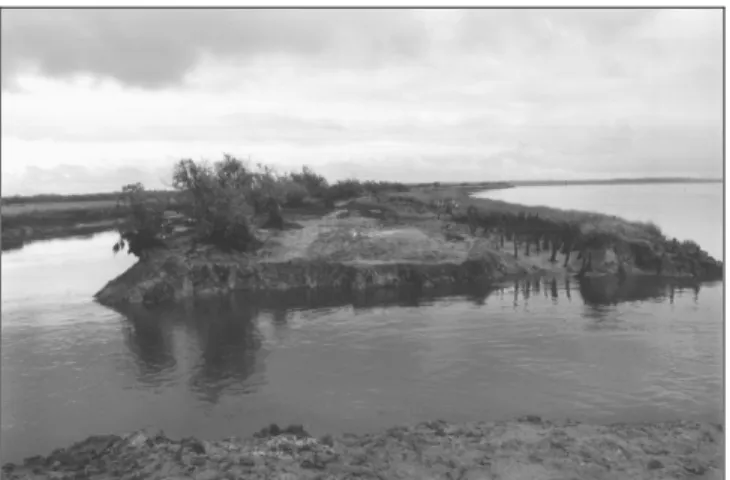
Thus rejection of the project at Graveyron can be explained by the fortuitous creation of a breach in 1996 which was not planned by man. It occurred during a storm and the Graveyron polder has thenceforth been exposed to the full forces of nature. Furthermore, the sea dikes surrounding the breach have continued to erode and will soon give way and tides have clearly aided in the regeneration of the saltmarsh (figure 4). Human intervention through the Conservatoire du Littoral has, in this case, been very limited and only involved maintaining the existing breach.
Figure 4: Accidental breach in the Graveyron-polder sea dike. From right to left in the background: Arcachon Bay (F), the still eroding sea dike and part of a growing saltmarsh (figure 2c).
At Noirmoutier the story is radically different. The scheme was accepted for it was to be carried out by the local authorities with the support of environmentalists and local associations. Furthermore, it included visible human intervention. Today passers-by can
perceive the tidal gates, the internal sea-water course (figure 2b) and the restructured farmland but in an environment in which the natural dynamics have on the contrary remained subtle; saltwater, being in this case perceivably similar to fresh water, has contributed to the regeneration of a small saltmarsh sheltered by the sea dike (figure 5). The same thing may be said about the English example at Freiston Shore. Man’s visible direct role in the managed realignment process was likely crucial in the public’s approbation: the three man-made breaches give the impression that Man continues to dominate the environment and has not yielded to Nature (figure 2e).
Figure 5: Former farming zone flooded and remodelled to permit the restoration of tidal flats and small parts of a saltmarsh, favorable to the avifauna (Sébastopol polder, Noirmoutier (F), Figure 2b).
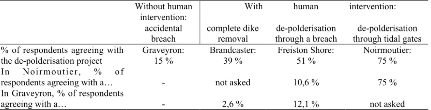
Thus, the degree of human intervention and, more precisely, the type of de-polderisation play a key role in a process which ostensibly is scantly appreciated without human control of the situation, as is the case at Graveyron with its fortuitous breach. Comparison of the five surveys or the individual examination of each (table 4) flagrantly indicates that voluntary-intervention options have obtained more public support. Nevertheless, where there has been voluntary intervention, people would rather it be limited in scope and man-made (through breaches as in Freiston Shore or gates as in Noirmoutier) than attain the point of complete dike removal, leaving the area fully exposed to the forces of Nature as at Brandcaster (table 4). Support for the scheme is all the more important when human intervention is strongly felt and when control of Nature remains possible.
Table 4. Opinions towards de-polderisation and types of de-polderisation schemes Without human
intervention:
With human intervention:
accidental breach complete dike removal de-polderisation through a breach de-polderisation through tidal gates % of respondents agreeing with
the de-polderisation project
Graveyron: 15 % Brandcaster: 39 % Freiston Shore: 51 % Noirmoutier: 75 % I n N o i r m o u t i e r , % o f
respondents agreeing with a… - not asked 10,6 % 75 %
In Graveyron, % of respondents
agreeing with a… - 2,6 % 12,1 % not asked
From : BARBE, 2005; MARCADET and GOELDNER-GIANELLA, 2005; MYATT-BELL et al., 2003a; MYATT-BELL et al., 2003b.
These results are in accordance with those of other surveys on people’s perception of the environment. Topical research has shown that society is willing to co-exist with a more untamed or even restored environment provided that it is well controlled and well managed
(BARON-YELLES and BRUN, 1998) or easy to access and non-threatening (KAPLAN, 1987).
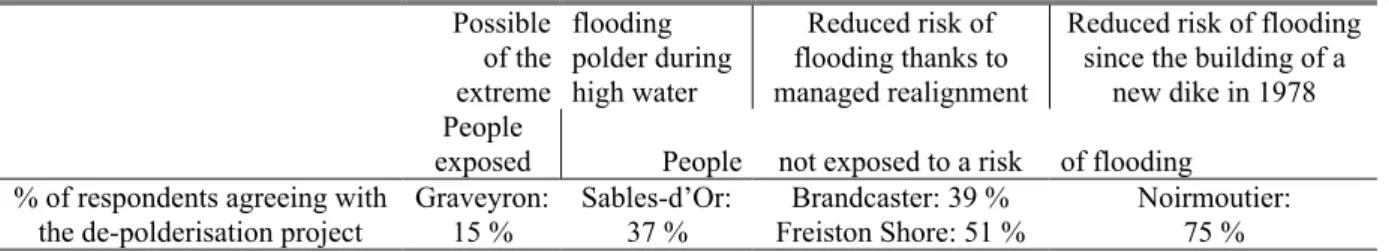
The Importance of the Local Physical Context
The third possible explanation for the diverging opinions is linked to the physical context of each site and especially to risk factor perception. What is first evident is that when erosion or flooding risks are low people tend to feel relatively safe and to be less overt in their opposition to a de-polderisation scheme which would not endanger their lives. On the other hand, firm opposition comes to the fore when the population perceives any risk of erosion or submersion (table 5).
Table 5. Opinions towards de-polderisation and local physical context Possible of the extreme flooding polder during high water Reduced risk of flooding thanks to managed realignment
Reduced risk of flooding since the building of a
new dike in 1978 People
exposed People not exposed to a risk of flooding % of respondents agreeing with
the de-polderisation project
Graveyron: 15 % Sables-d’Or: 37 % Brandcaster: 39 % Freiston Shore: 51 % Noirmoutier: 75 %
From : BARBE, 2005; GOELDNER-GIANELLA and IMBERT, 2005; MARCADET, 2004; MYATT-BELL et al., 2003a; MYATT-BELL et al., 2003b.
Such is the case at Graveyron where the inhabitants can perceive the risk of erosion around the breach (figure 4). And as the population was reminded in December 1997, at extreme high water the whole polder, both the de-polderised area as well as the polder behind it (figure 2c), already suffers flooding due to the low sea dike. Furthermore, a recent study showed that if current higher high water levels are only slightly exceeded, sea level rise will likely cause total submersion of the site within the next century (GOELDNER-GIANELLA et al., 2003). Flooding would then attain the town of Audenge (figure 2c)! At Sables-d’Or the polder is protected from direct exposure to the sea by a sand spit, a saltmarsh and a floodable road (figure 2a) but is susceptible to flooding during extreme high water. However, it would not directly affect a population both set back from the polder itself and on higher ground. At Brandcaster the population is equally out of reach (figure 2d) and the managed realignment scheme has reduced the risk of flooding from the present level of one in five years to one in fifty years (MYATT-BELL et al., 2002). At Freiston Shore, managed realignement has also contributed to a reduction in the risk of flooding which in the past was high due to its dike being located too far from shore and no longer protected by a saltmarsh (figure 2e). The site was susceptible to rapid submersion. Over recent winters erosion events have consequently been numerous and will only degenerate with sea level rise, threatening 800 km2 of farmland and the town of Boston. The Environment Agency has thus suggested implementing managed realignment through the construction of a new cross-bank and the strengthening of the landward bank (Environment Agency et al., 1999). The acceptance of the de-polderisation project is certainly linked to this better flood defence option. Lastly, at Noirmoutier, despite its exposure to the sea, the Sébastopol polder is nonetheless protected by a high sea dike which was re-built following the storm of 1978 (VERGER, 2005) that had engendered breaches and flooding up to the Rural District of Barbâtre (figure 2b). Today its population feels completely safe and largely approves a de-polderisation scheme which has permitted to maintain the flood defence system. An in-depth cross-connection analysis of the Noirmoutier survey supports these hypotheses (table 6). It illustrates that even if the population questioned approves of the scheme in its current form, a majority consider that a higher degree of
de-polderisation through a breach would certainly entail a more serious risk for the District of Barbâtre.
Table 6. Opinions towards two degrees of de-polderisation at Noirmoutier Respondents thinking that a
higher degree of de-polderi-sation would constitute a risk
for the District of Barbâtre
Respondents thinking that a higher degree of de-polderisa-tion would not constitute a risk
for the District of Barbâtre
Respondents having no
opinion Respondents agreeing with the
current de-polderisation scheme at Noirmoutier
130 11 10
Respondents not agreeing with the current de-polderisation scheme at Noirmoutier
13 10 27
N = 201; chi-square= 70,68; DF = 2. Adapted from BARBE, 2005.
With the potential reasons behind such varied opinions having been determined, it would only seem appropriate to suggest a remedial plan for the knowledge gap on marsh environments.
Propositions: Better Inform to Better React
The knowledge deficit can, it would seem, be overcome and more support for projects created through the development of environmental awareness and, more precisely, information on the marsh environment and the impacts of de-polderisation. From the five studies one can surmise that the better informed society is (Freiston Shore, Noirmoutier) the more likely it is to accept a scheme with its corollary being true as well (Sables-d’Or, Graveyron).
This lack of information was strongly felt by those surveyed.At Sables-d’Or 75% of them claimed that “they had not been sufficiently educated about the environmental value of the saltmarsh”. Similarly at Graveyron 70% considered that “reception of the public and environmental education of the site should be improved”. They even cited a desire to have access to information panels, leaflets, guided tours, just as at other European protected-marshes where this is becoming more and more common. On the other hand, this information must be sufficiently detailed so as not to leave the public with only mental landscape impressions or superficial knowledge: andso, albeit that 75% and 57% of those surveyed at Brandcaster and Freiston Shore respectively were aware of the managed realignment scheme (MYATT et al., 2003a and 2003b) it had no impact on their environmental knowledge level.
Still the question remains what are the best means available for communicating information to the public. Firstly, information should be made more readily accessible and widespread so as to reach a maximum number of people. Freiston Shore represents a good example of the different possibilities available to planners to inform and win acceptance of a project: letters to residents, information flyers, public workshops, newspaper articles, planning notices as well as direct contact with stakeholders and inhabitants (J. Badley, RSPB, pers. comm.). As a consequence of this relentless information campaign, the local RSPB have observed a “massive culture change”. Secondly, informing the public must be carried out over a longer period of time (i.e. before, during and after the works) as was once again the case at Freiston Shore. In England the Department for Environment, Food and Rural Affairs has recommended this procedure for any future endeavours of managed realignment (DEFRA et al., 2002, p.197). Lastly, the most up-to-date means should be employed to instruct the public. For instance, relatively constructive methods such as steering groups and local fora which were tested at Brandcaster and Thorngumbald (Humber estuary) (DEFRA et al., 2002, p.
197), associated with topic groups and questionnaires addressed to the wider community, could be used in conjunction with more experimental means. With this in mind, JUDE et al. (2001) developed a Virtual Reality Geographical Information System (VRGIS) in order to illustrate in 3D to the public and to administrators how a de-polderised site would evolve over time: “The VRGIS may communicate, educate, inform and involve the public and stakeholder groups in coastal management decisions by presenting information in a recognisable and understandable format”. The efficacy of this means of sharing information is all the more important since Society has become so landscape sensitive.
As the surveys have indicated, it would also be useful to target a specific group, that is one which is older, resides by the polder and is interested in the site. Other surveys have already shown that those most likely to react and take part in the implementation of new coastal schemes were typically from the local rural population (i.e. those living nearest the coast and most affected by changes to its environment) (EDWARDS et al., 1997). However, this targeting method does not mean that more general information on tidal marshes and de-polderisation should not be communicated to the public via the media or revues for the popularization of the sciences. And of course, it is essential that the local population have the possibility of taking part in the final decision and not suffer having the finished product imposed upon it, which, in the U.K., has oft caused overt opposition to certain draft plans (EDWARDS et al., 1997). Thus, those surveyed suggested that people be henceforth consulted once “the Environment Agency has selected a number of possible options for the coastal defence scheme that the public can choose between” (MYATT et al., 2003a and 2003b).
CONCLUSIONS
Comparison of the five public-opinion surveys carried out in the U.K. and in France revealed that public perceptions and attitudes towards de-polderisation vary widely, ranging from strong opposition to strong acceptance, with indifference being unexpectedly common at times. A statistical analysis showed that those most hostile to the de-polderisation process were generally older and possessed little knowledge of the marsh and polder environments.
Secondly, as MYATT-BELL et al. had already underlined in their pilot survey at Brandcaster (2002), perceptions and attitudes are the result of many variables, thus complicating our comprehension of the phenomenon. However, this vast field of explanations should be understood by planners in its entirety if they wish to better understand the public and implement other projects. They should therefore systematically take into consideration the following:
- the public’s scant knowledge of the environment and physical context which must be improved if it is to better understand and accept any future de-polderisation project,
- the importance of landscape to today’s society which should lead planners during the decision-making process to be very conscious of visual aspects such as the degree of erosion or the level of human control of the processwhich might have been hitherto considered of minor importance, and
- the future of coastal polders as regards sea level rise. Given how much the degree and inevitability of risk can influence public opinion, it is essential that society be properly informed. However, if we are to take into account the long term evolution of polders, it can only be done with the support of the appropriate scientific studies that are to this day still insufficient. In France, the Conservatoire du Littoral, which has already acquired 10% of the country’s coastline - and thus many of its polders -, has begun a study on the impacts of sea level rise in order to locate those that might undergo submersion over the course of the 21st century and which could eventually be restored to the sea.
Lastly, while case-by-case analyses are necessary to unveil a certain number of factors, we feel it necessary to produce a comprehensive view of the knowledge acquired through the creation of a “bank of variables” capable of explaining society’s reactions to de-polderisation, whether they be systematic or isolated. Public perception could be better defined through an increase in the number of surveys and analyses, which will help planners make the best choices, not only from a defence, economic and environmental standpoint, but from a social point of view as well.
ACKNOWLEDGEMENTS
The author would like to thank Wayne Iwamoto for the translation of the article and the students Justine Barbe and Claire Marcadet for their data-collecting efforts at Noirmoutier and Graveyron, with the support of the District of Noirmoutier (R. Marty) and the Conservatoire du Littoral (I. Kisielewski, délégation Aquitaine) respectively.
LITERATURE CITED
BARBE, J., 2005. Agriculture et environnement à Noirmoutier : les destins divergents de la plaine de Barbâtre et du polder de Sébastopol. Paris, France: University of Paris I, Maîtrise de Géographie, 132p.
BARON-YELLES, N., 1999. La fréquentation touristique des espaces protégés littoraux : cas des réserves ornithologiques bretonnes de Cap Sizun et de l’île de Groix. Géocarrefour, 1, 85-95.
BARON-YELLES, N. and BRUN, J., 1998. L’univers des opinions sur l’environnement. In: COLLOMB, P. and GUERIN-PACE, F (ed.)., Les Français et l’environnement. L’enquête Populations - espaces de vie - environnement. Paris, France: INED, PUF diffusion, collection Travaux & Documents, pp. 65-104.
BARON-YELLES, N. and GOELDNER-GIANELLA, L., 2001. Les marais maritimes d’Europe atlantique. Paris, France: PUF, 294p.
BROOKE, J.S., 1992. Coastal defence: the retreat option. Journal of the chartered institution of water and environmental management, 6, 151-157.
BUND; Landesverband Bremen, and Landesverband Niedersachsen (Hrsg.), 2003. Wiederherstellung von tidebeeinflussten Lebensräumen: Erfahrungen und Perspektiven. Bremer Beiträge für Naturkunde und Naturschutz, Band 6, 137p.
BUSS, T., 2001. Hochwasserschutzmassnahmen an der Tide-Elbe in Hamburg. Naturschutz kontra Sicherheit ? Wasser und Boden, 12, 21-36.
CHADENAS, C., 2003. L’homme et l’oiseau sur les littoraux d’Europe occidentale. Appropriation de l’espace et enjeux territoriaux: vers une gestion durable ? Nantes, France: University of Nantes, Ph.D. thesis, 341p.
Conservatoire du Littoral, 1996. Attention Public! Public protecteur ou public prédateur? Les Annales 96, 11, 31-54.
Conservatoire du Littoral, 1999. De la nature conquise à la nature conquérante. La dépoldérisation: ouvrons les digues. Les Ateliers du Conservatoire du Littoral, 19, 16p.
COLLOMB, P. and GUERIN-PACE, F., (ed.)., 1998. Les Français et l’environnement. L’enquête Populations - espaces de vie - environnement. Paris, France: INED, PUF diffusion, collection Travaux & Documents, 255p.
DEFRA (Department for Environment, Food and Rural Affairs); Environment Agency, and Flood and Coastal Defence R&D Programme, 2002. Managed Realignment Review, R&D Technical Report FD2008. 212p.
EDWARDS, S.D.; JONES, P.J.S., and NOWELL, D.E., 1997. Participation in coastal zone management initiatives: a review and analysis of examples from the UK. Ocean & Coastal Management, 36(1-3), 143-165.
Environment Agency; English Nature; RSPB, and HM Prison Service, 1999. Protecting the Lincolnshire Wash Coast. Peterborough, UK:, AN11/99-2K-C-BEYQ, p.5.
FRENCH, P.W., 2001. Coastal defences: processes, problems and solutions. London, UK: Routledge, 366p.
GILL, J., 2001. Concluding thought. Managed realignment: habitat creation in the coastal zone. In: GILL, J.; O’RIODAN, T., and WATKINSON, A., (ed.), Redesigning the coast – Science Workshop (October 2001), pp. 72-73.
(www.tyndall.ac.uk/research/theme4/workshop1/full_report.pdf).
GOELDNER, L., 1999. The German Wadden Sea coast: reclamation and environmental protection. Journal of Coastal Conservation, 5, 23-30.
GOELDNER-GIANELLA, L .; ANSELME, B.; BERTRAND, F., and DURAND, P., 2003. Recul du trait de côte et orientations stratégiques dans le Domaine de Graveyron (bassin d’Arcachon, Gironde). Technical report for the Conservatoire du Littoral, 47p.
GOELDNER-GIANELLA, L. and IMBERT, C., 2005. Représentations sociales des marais et dépoldérisation. Le cas d’un marais breton. L’Espace Géographique, in press.
GOODWIN, P. and WILLIAMS P., 1992. Restoring coastal wetlands: the Californian experience. Journal of the chartered Insitution of Water and Environmental Management, 6, 709-719.
HERVIEU, B. and VIARD, H., 2001. Au bonheur des campagnes. Paris, France: L’Aube, 155p.
JUDE, S.; JONES, A.P.; ANDREWS, J.E., and BATEMAN, I., 2001. Visualisation for Coastal Zone Management: A Case Study of the Norfolk Coast, England. In: GILL, J.; O’RIODAN, T., and WATKINSON, A. (ed.), Redesigning the coast – Science Workshop (October 2001), pp. 61-70, (www.tyndall.ac.uk/research/theme4/workshop1/full_report.pdf).
KAPLAN, S., 1987. Aesthetics, affect and cognition: environmental preference from an evolutionary perspective. Environmental Behavior, 19, 3-32.
LEDOUX, L.; CORNELL, S.; O’RIORDAN, T.; HARVEY, R., and BANYARD, L., in press. Towards sustainable flood and coastal management: identifying drivers of, and obstacles to, managed realignment, Land Use Policy.
MACLEOD, M.; DA SILVA, C.P., and COOPER, J.A.G., 2002. A comparative study of the perception and value of beaches in rural Ireland and Portugal: implications for coastal zone management. Journal of Coastal Reserarch, 18(1), 14-24.
MARCADET, C., 2004. La réouverture du polder de Graveyron (bassin d'Arcachon, Gironde): risque de submersion, réactions sociales et gestion du site. Paris, France: University of Paris I, Maîtrise de Géographie, 97p.
MARCADET, C. and GOELDNER-GIANELLA, L., 2005. Dépoldériser dans le bassin d’Arcachon ? Réactions sociales et propositions de gestion. Norois, 197, in press.
MARTY, R., 2000. Du polder de Sébastopol au parc littoral du Gois. Document de présentation synthétique. Noirmoutier, France: District de Noirmoutier, 20p.
MEUR-FEREC, C.; HOEDT, M., and DANES, L., 2001. Fréquentation des sites naturels littoraux. Vers une meilleure connaissance du public: l’exemple de deux sites dunaires à l’est de Dunkerque. Hommes & Terres du Nord, 2, 81-89.
MYATT, L.B.; SCRIMSHAW, M.D., and LESTER, J.N., 2003a. Public Perceptions and Attitudes towards a Current Managed Realignment Scheme: Brancaster West Marsh, North Norfolk, UK. Journal of Coastal Research, 19(2), 278-286.
MYATT, L.B.; SCRIMSHAW, M.D., and LESTER, J.N., 2003b. Public perceptions and attitudes towards a forthcoming managed realignment scheme: Freiston Shore, Lincolnshire, UK. Ocean & Coastal Management, 46, 565-582.
MYATT, L.B.; SCRIMSHAW, M.D., and LESTER, J.N., 2003c. Public perceptions and attitudes towards an established managed realignment scheme: Orplands, Essex, UK. Journal of Environmental Management, 68(2), 173-181.
MYATT-BELL, L.B.; SCRIMSHAW, M.D.; LESTER, J.N., and POTTS, J.S., 2002. Public perception of managed realignment: Brandcaster West Marsh, North Norfolk, UK. Marine Policy, 26, 45-67.
NORDSTROM, K.F. and MITTEAGER, W.A., 2001. Perceptions of the value of natural and restored beach and dune characteristics by high school students in New Jersey, USA. Ocean & Coastal Management, 44(7-8), 545-559.
RUPP, S. and NICHOLLS, R.J., 2002. Managed realignment of coastal flood defences: a comparison between England and Germany, 10p, www.survas.mdx.ac.uk/public11.htm.
TAPSELL, S.; FORDHAM, M.; TUNSTALL, S., and HORNE, M., 1994. The river environment and you: postal survey Datchet to Walton Bridge. Final report to the National Rivers Authority. Enfield: Middlesex University, Flood Hazard Research Center. 115p.
TITUS, J.G., 1991. Greenhouse effect and coastal wetland policy: how Americans could abandon an area the size of Massachusetts at minimum cost. Environmental Management, 15(1), 39-58.
TUNSTALL, S., 2000. Public perception of the environmental changes to the Thames Estuary in London, UK. Journal of Coastal Research, 16(2), 269-277.
TUNSTALL, S.M. and PENNING-ROWSELL, E.C., 1998. The English Beach: Experiences and Values. The Geographical Journal, 164(3), 319-332.
VEGA-LEINERT (de la), A.C. and NICHOLLS, R.J., 2001. Les conséquences socio-économiques de l’élévation accélérée du niveau de la mer au Royaume-Uni. In: PASKOFF, R. (éd.), Le changement climatique et les espaces côtiers : L’élévation du niveau de la mer: risques et réponses, Actes du colloque d’Arles, 12 et 13 octobre 2000, Mission Interministérielle de l’effet de serre, pp.48-57. www.survas.mdx.ac.uk/public11.htm.
VERGER, F., 2005. Marais et estuaires du littoral français. Paris, France: Belin, 335p.
RESUME
En Europe occidentale, les premières “dépoldérisations” remontent aux années 1980. Mais celles-ci ne se sont multipliées qu’en Grande-Bretagne, où des objectifs de défense côtière (managed realignment) s’ajoutent à des objectifs environnementaux, ailleurs prédominants. Ces dépoldérisations sont de divers types : entrée d’eau de mer dans un polder à travers des écluses ou des brèches, ou véritable démantèlement d’une digue. Leurs impacts physiques restent insuffisamment étudiés, mais c’est encore plus vrai des réactions sociales qu’engendrent ce retour de la mer et ces restaurations de marais – réactions expliquant pourtant les échecs ou les succès de cette politique. Nous avons ainsi étudié la perception sociale de la dépoldérisation, en comparant cinq des premières enquêtes d’opinion effectuées en France et en Angleterre. Selon les sites, les résultats montrent des opinions très variées, mais aussi parfois une grande indifférence à l’égard des dépoldérisations. Si on peut établir le profil des opposants au processus (des personnes relativement âgées, résidant à proximité des sites dépoldérisés et les fréquentant régulièrement), les réactions “négatives” auraient surtout un rapport avec les faibles connaissances de la Société sur l’environnement des marais et les impacts des dépoldérisations. Mais d’autres éléments expliquent ces réactions : le fait que la nature littorale ne soit plus qu’un “Paysage” pour la Société, le degré varié de maîtrise des dépoldérisations et de leurs effets, le contexte physique local et le degré d’information des habitants. Or, on pourrait améliorer les connaissances et faire évoluer les mentalités locales en modernisant les méthodes de communication. Enfin, la constitution d’une banque de variables, expliquant plus systématiquement ces réactions, aiderait les aménageurs à gérer le processus sur le plan social.