HAL Id: hal-03030068
https://hal.archives-ouvertes.fr/hal-03030068
Submitted on 1 Dec 2020HAL is a multi-disciplinary open access
archive for the deposit and dissemination of sci-entific research documents, whether they are pub-lished or not. The documents may come from teaching and research institutions in France or abroad, or from public or private research centers.
L’archive ouverte pluridisciplinaire HAL, est destinée au dépôt et à la diffusion de documents scientifiques de niveau recherche, publiés ou non, émanant des établissements d’enseignement et de recherche français ou étrangers, des laboratoires publics ou privés.
Mapping walkability. A subjective value theory
approach
Giovanna Fancello, Tanja Congiu, Alexis Tsoukias
To cite this version:
Giovanna Fancello, Tanja Congiu, Alexis Tsoukias. Mapping walkability. A subjective value theory approach. Socio-Economic Planning Sciences, Elsevier, 2020, 72, pp.100923. �10.1016/j.seps.2020.100923�. �hal-03030068�
1
Mapping Walkability. A subjective
value theory approach.
Giovanna Fancello1a, Tanja Congiub, Alexis Tsoukiàs a.
a. LAMSADE, PSL University, CNRS, Paris Dauphine, Place du Maréchal de Lattre de Tassigny,75016, Paris, France
b. Department of Architecture, Design and Urban Planning, University of Sassari, Italy
Keywords: walkability; multi-criteria decision analysis; capability approach; preferences;
multi-attribute value theory; decision maps.
Abstract
The analysis of urban walkability has been extensively explored in the last decades. Despite this growing attention, there is a lack of studies attentive on how citizens’ values, individual abilities and urban environment favour or hinder the propensity to walk. Hence, there is a need to explore how preferences and values of citizens vary in space in order to design walkability policies able to improve the capability set of citizens. In this perspective, the design of spatial decision tools aimed to planning public policies for the development of walkable cities needs further investigation. We propose a Multiple Criteria Decision Analysis (MCDA) method aimed to elaborate walkability decision maps for different groups of citizens that reflect their capability to walk in the urban environment. We tested the method in the city of Alghero (Italy). First, we analysed walkability under a normative model named CAWS; then we made a survey with 358 participants in order to study the driving values that influence their choice to walk and finalised to build an evaluation model attentive to individual differences. Cluster analysis was employed to group citizens into 11 groups based on their sociodemographic characteristics and preferences on spatial criteria of walkability. Finally, by integrating the GIS with the MCDA we built a set of decision maps representative of the walkability of the different groups of citizens. Results highlight the importance of citizens’ values for policy design, allow the interpersonal comparison among individuals and group preferences and give new suggestions for the formulation of walkability oriented urban policies. Moreover, the results confirm the usability of the general method as a decision support tool supporting the design of urban policies.
1 Corresponding author
Present address: UMR 8504 Géographie-cités, CNRS, Université Paris 1 Panthéon-Sorbonne, Université Paris Diderot, EHESS, Campus Condorcet, 5, cours des Humanités, 93322 Aubervilliers cedex
e‐mail: [email protected] (Giovanna Fancello)
Funding: This project was supported by the PSL Research University with the Project MMAP "Measuring the maps".
2
1 Introduction
Walkability is an important component in Urban Quality of Life (Rogers, Halstead, Gardner, & Carlson, 2011; Talen, 2002), that allows to expand the possibilities of people to use and act in the city with reference to their needs and values. For this reason, it is one of the main aims of urban public policies in the last decades (Barton, Thompson, Burgess, & Grant, 2015; Gehl, 2010; Oka & Koohsari, 2020; Speck, 2018).
However, in the design of public policies it is not sufficient to claim that a walkable space is preferable to other spaces in order to support the policy making. In order to establish the precise set of actions which will improve walkability, we need to know – among other – how walkability is valued by different groups of citizens. Such analysis gives useful information for taking a public decision and for the design of a legitimated public policy (Meinard, 2017). Accordingly, beside their objective characteristics, citizens can be grouped on the basis of their subjective values. This allows to take into account the diversity of citizens in terms of preferences and needs (Ferretti, Pluchinotta, & Tsoukiàs, 2019; Goodin, Moran, & Rein, 2008; Simon, 1954, 1969).
The best known walkability analysis methods (Carr, Dunsiger, & Marcus, 2010; Ewing & Handy, 2009; Frank et al., 2010; Iacono, Krizek, & El-Geneidy, 2010; Owen et al., 2007) present a normative-descriptive conceptualisation based on generalised rules applicable to a wide range of situations and individuals with no distinction for specific categories of citizens. Some models focus on specific groups of population (elderly, disabled people, children) and attempt to identify the factors that most affect their decision to walk (Bejleri, Steiner, Fischman, & Schmucker, 2011; Buck et al., 2011; Garin et al., 2014; Guo & Loo, 2013; Moura, Cambra, & Gonçalves, 2017; Taleai & Taheri Amiri, 2017; Towne et al., 2016), but the majority of them refer to the behaviour of a standard walker with no distinction among subjective preferences or needs, thus demanding for more personalisation.
Moreover, it is broadly acknowledged that the results of urban audits, used for the analysis of walkability, are affected by citizens’ preferences which are very different from each other. Such a problem, usually considered a bias of the model, represents in our idea an opportunity for policy design. Policy design takes advantage from differences that offer an opportunity for innovative design (Ferretti et al., 2019). In other words, the diversity of citizens’ preferences is a very useful information for building legitimated policies (Matti, 2004; Meinard, 2017).
Starting from these considerations, our focus in this paper is to improve the methodological background of walkability assessment tools and their effectiveness for policy design. We are interested in analysing citizens’ values in space in order to design public policies attentive to individual diversities. Especially, we need to understand how different groups of citizens consider and react to the socio-spatial features that describe the walkability in the city. Hence the conditions and qualities of the urban environment that count in the decision to walk for different groups of individuals and their relative value are investigated. For this purpose, we propose a method attentive to individual diversity to be used as support tool for the design of policies in the city of Alghero (Italy) selected as case study. Operationally, this method yield to a definition of a set of decision maps (Malczewski, 1999; Malczewski & Rinner, 2015) representative of the walkability of the different groups of citizens.
3
and based on normative prescriptions), our theoretical framework for the analysis of citizens’ quality of life in cities is the Capability Approach (Nussbaum, 2005; Sen, 2009) based on individuals substantive freedoms (capabilities) to choose a "life one has reason to value" (Sen, 2009). Citizens’ capabilities are valuable states of being that a person has effective access to (Sen, 2009). The development of capabilities depends from individual and environmental factors: (1) the ability, the person’s internal power, detained but not necessarily exercised, to do and to be, and (2) the opportunity, the presence of external conditions which make the exercise of that power possible (Blečić, Cecchini, Congiu, Fancello, Talu, et al., 2015). Thus, the quality of life of citizens in a city is not given by the measure of distribution, density and distances of different opportunities in space. Rather, quality of life in cities is a multidimensional concept that depends on individual diversity and on the advantage that such urban opportunities give to citizens in order to develop capabilities.
Under such a perspective, citizens’ values are fundamental for the process of choice of capabilities that can be developed into functionings, and therefore for the improvement of their quality of life in cities. Diversities among individuals (age, gender, health conditions, income, driving licence, place of residence, …) can correspond to different values and to different possibilities “to do and to be” (Sen, 2009) in urban space.
The multi-attribute value theory family methods (Keeney & Raiffa, 1976; von Winterfeldt & Edwards, 1986) satisfies the demand of considering both the multidimensionality and the subjectivity of welfare. Thus, by using such family of methods, we intend to study values in order to group citizens primarily with respect to their preferences to do and to be in space, and secondarily with respect to their characteristics. Our hypothesis is that values functions are a good representation of each citizen driving values. Such an analysis consents to identify groups of citizens that would otherwise be invisible using a standard segmentation of the population (for example for ranges of ages).
Therefore, the main innovation of the proposed method is given by the focus on individual diversity for policy making. After a multiple criteria analysis of walkability, we propose to analyse the subjective character of well-being constituents (as it is the case with walkability) using the multi-attribute value theory methods. Finally, we explore both the multidimensional and subjective spatial variability of the walkability by grouping citizens (considering their needs and values) and by designing a set of decision maps representative of urban capabilities and limits. The final decision maps give useful information for policy designs focused on citizens’ diversity. Thus, our main contribution to the literature on decision making for urban policies is a capability-oriented decision analysis method through which it is possible to establish a “customised” walkability model for a given urban context and population that highlight differences on urban capabilities.
According to these considerations, our research problem can be structured in three principal points:
(1) The definition of the criteria which describe walkability in our case study (Alghero). Walkability is a multidimensional and complex concept which requires the use of multiple criteria decision analysis methods (MCDA) to be measured and evaluated. Despite the great production of walkability studies (Blečić et al. 2015a; Cervero & Duncan 2003; Clifton et al. 2007; Forsyth 2015; Frank et al. 2006; Iacono et al. 2010; Lee & Moudon 2006; Livi & Clifton 2004; Porta & Renne 2005; Saelens & Handy 2008), there is no consensus about the criteria that must be considered in an analysis tool due to context embedded factors and to the diversity of city users. For this reason, we define a set of tailor-made criteria and attributes for the city of Alghero based on the idea of
4
walkability as an urban capability (Blečić, Cecchini, & Talu, 2013; Blečić, Congiu, Fancello, & Trunfio, 2020).
(2) The analysis of the trade-offs between walkability criteria that reflect the preferences of decision makers here represented by the whole population of a city (residents, city users, tourists, …). Above all, we are interested in recognising the differences between the values that distinct groups of citizens give to the walkability components in order to tailor policy interventions.
(3) The consideration of the “spatial component” in the evaluation process. The spatial representation resulting from an evaluation attentive to the diversities in urban space must be the result of the combination of the environmental features and their values for the citizens and not just a superposition of layers. The resulting maps (here named “decision maps”) are representative of two components: 1) the spatial relations between the urban features and their specific location in the city and 2) the subjectivity of the walkability which takes into account the different values citizens gives to multiple walkability criteria. Decision maps consent to select among two alternatives because of their different spatial location, independently from their walkability assessment. Indeed, a change in the location of an alternative (here represented by the disparate possibilities to walk in the city) influences its final evaluation (Malczewski & Rinner, 2015). This change is due to the multiple interconnected environmental features that need to be considered when spatial analysis is required (Malczewski & Rinner, 2015). Decision maps help in showing the differences of capabilities among individuals when the city and its walkable space is assessed by them. It is the case when two different citizens consider the same street and assess its walkability differently due to their different capability sets.
In order to integrate the spatial component, we combine the MCDA method with GIS services (Malczewski, 1999; Malczewski & Rinner, 2015). The GIS-MCDA model we proposed consents to 1) unveil specific spatial relations among the variables that describe a walkable environment and 2) catch the differences between the walkability of groups of citizens. Both these points give useful outputs for the policy design
The abovementioned three points are analysed in the following paragraphs. More precisely, in section 2 we articulate our theoretical background, then we argument our method in section 3, while in sections 4 to 7 we give operational details through the description of a case study. Conclusions are drawn in section 8.
2 Theoretical background
2.1 Analysis of walkability.
Walkability is the potential of the built environment to encourage individuals walking. Among the multiple definition of walkability we claim it is a composite quality of urban space produced by the combination of several spatial factors related to the organisation and functionality of cities: the physical configuration of the urban fabric with its block structure and the connectivity of pathways; the presence and variety of activities intended as possible origin and destinations of trips; the quality of pedestrian accessibility which depends on the level of comfort, convenience, safety and pleasantness of footpaths, as well as on the attractivity and imageability of the traversed environment. Most walkability assessment methods are based on these features of the built environment (Blečić et al. 2015; Forsyth & Krizek, 2010; Pikora et al., 2003; Saelens & Handy, 2008). The importance assigned to each of them and the choice of measurement variables
5
depend on the specific context of implementation which differ in geographical and cultural characteristics (for instance, safety and security issues highly affect the propensity to walk in cities with high levels of traffic accidents and crime) as well as for the amount of resources available for the study (time, economic funds, dataset accessible, …).
Urban walkability is an operationalizable concept. As an indicator of how, where and to what extent urban environment is conducive to walk, it can be measured and spatialized. Most methods resort to composite indexes that combine in different ways the multiplicity of factors involved in the assessment. The main differences consist in the variables considered, in the algorithm used, data collection techniques adopted and outcomes. In their review of existing pedestrian indices Maghelal & Capp (2011) distinguished between (1) methods that quantify the amount of built-environment features into a single number that categorizes the physical environment as high, low, or moderately suitable to walk, and (2) methods such as audits, surveys and checklists that tend to measure the amount of built-environment features that support or hinder walking.
Recent advancements in spatial analysis, modelling and computing led to the development of several sophisticated walkability measurement methods and tools. Such tools are used by researchers, urban planners and practitioners in order to analyse and evaluate the walkability of the built environment, to represent the distribution in space of this quality and to explore its influence on people behaviour (Adlakha, 2017; Bader et al., 2015; Badland et al., 2013; Frank et al., 2006; Iacono et al., 2010; Peiravian, Derrible, & Ijaz, 2014; Sundquist et al., 2011; Van Dyck et al., 2013; Yameqani & Alesheikh, 2019). In fact, these methods are able to pinpoint how and to what extent urban environment encourages walking and makes urban opportunities reachable and available for use. The resulting knowledge can be used to inform urban policies and projects aiming to encourage active lifestyles and enhance people well-being. The decision of a person to walk is in fact influenced by a number of spatial and a-spatial factors (Alfonzo, 2005; Carlson et al., 2012; Forsyth et al., 2009; Handy, 1997). Urban planners and designers can act, first of all, on the spatial qualities making urban environment more conducive to walk for the majority of citizens. The walkability analytical methods we refer to in this study combine objectively measurable physical and functional characteristics of pathways (sidewalk presence and width, number of lanes, speed limits, ….) with urban design qualities affecting people’s perception of the walking environment (imageability, enclosure, transparency) and other factors related to how pedestrians react to urban space (Ewing & Handy, 2009; Moudon & Lee, 2003). Moreover, walkability has a subjective value for each individual citizen. Various studies (Ewing & Handy, 2009; Gebel, Bauman, Sugiyama, & Owen, 2011; Zhou, He, Cai, Wang, & Su, 2019) suggest that such subjectiveness results from two components:
- the subjective appreciation of what is relevant and important for a "space" to be walkable, this being independent from the socio-economic characteristics of the citizen; - the subjective importance of how walkability of the surrounding space impacts the overall well-being of each citizen, the willingness and pleasure to walk being different and once again independent from the socio-economic characteristics of each citizen. Indeed, the propensity of people to walk is influenced not exclusively by the presence and width of sidewalks or the distance to travel; it counts also if a path is pleasant and attractive to walk, if it is comfortable and perceived as safe and inclusive (Blečić et al., 2020; Forsyth, 2015; Talen, 2002). Therefore, we claim that convenience, comfort, safety, attractiveness and pleasantness represent essential spatial requirements that make
6
walkability measures effective indicators of the quality of accessibility and thus to be included and evaluated in an accurate analysis of the distribution of the capability to walk in the city.
The complex nature of the walkability concept, which encompasses the abovementioned objective and subjective features of the built environment, leads most walkability measures to be formalised by composite indices that combine factors with different importance. The most used methods (Carr et al., 2010; Frank et al., 2010; Krizek, 2003; Saelens, Sallis, Black, & Chen, 2003) resort to normative models in which the importance of factors involved in the decision to walk is assigned through a set of rules a priori based on an exogenous rationality, that is a rationality independent of the preferences of a specific decision maker (group of pedestrians) and thus applicable to a generality of situations.
However, there are many differences in the walking behaviour of people to be considered for making pedestrian friendly planning and design more effective. Individual characteristics, together with individual preferences influence the attitude of pedestrians in space. People with physical disabilities can be limited to access the city because of an unfriendly design of streets, in the same manner other citizens can modify their walking behaviour depending on the presence of specific qualities of urban space. This aspect lays even more emphasis on the analysis of the values citizens assign to walkability factors and their context-sensitive variability. The study of subjective values will permit thus to consider both citizens’ needs (derived from people characteristics) and preferences in order to meet a more effective and inclusive design of the urban environment.
2.2 The capability approach.
As already mentioned, the Capability Approach (Sen, 1999, 2009) is our theoretical framework for the definition of walkability. The Capability Approach goes beyond the economic concept of well-being, stressing the importance of evaluating not primary goods or assets, but substantive freedoms (named capabilities) to choose a "life one has reason to value" (Sen, 2009). The concept of capability entails two components (Blečić et al. 2015a): the "ability" of an individual with respect to his personal characteristics, and the "opportunity" given by the socio-environmental context to freely access the set of resources and assets in terms of endowments. Thus, the capability set of a person depends both on individual and environmental factors (conditions and commodities) (Errore.
L'origine riferimento non è stata trovata.). The aim of this approach is to enhance the
freedom people have to choose their beings and doings (capability set) through the conversion of such commodities and conditions in advantage for their development.
7
Figure 1: Determinants of well-being with specific attention to walkability (source: Author’s elaboration from Robeyns (2017)
The notion of advantage deals with a person’s real opportunity to use commodities compared to others (Sen, 2009). The advantage people take from the opportunity offered by the commodities is thus different for each individual. People can have different functionings (beings and doings) and a different capability set (combination of possible functionings) depending on socio-environmental factors. Likewise, the same person can convert the same commodity differently in different spaces, as well as two different persons in the same place may convert the same asset in different functionings. For all these reasons, the context plays a key role in the process of capability development. As claimed by (Blečić, et al., 2015a; Blečić, Cecchini, & Talu, 2013)there is a particular set of capabilities, named "urban capabilities", that is influenced by urban and territorial factors and the social context. Urban capabilities depend on urban and environmental opportunities intended as combinations of contextual factors that can be modified with a public policy. The walkability in the city is one of such urban capabilities (Blečić, Cecchini, Congiu, Fancello, & Trunfio, 2015; Blečić et al., 2013).
According to these premises, we are interested to determine the values citizens give to urban and environmental factors that influence the walkability of places, and thus the urban capability set of citizens. These elements are the contextual factors that influence the choice to develop the urban capability to walk in the city.
The recognized multidimensional and subjective character of well-being leads us to move the analysis of walkability from a normative approach (used by the majority of walkability researches) to one attentive to the differences among citizens. For this reason, we resort to the multi-attribute value theory methods which allows analysing the complexity of the well-being constituents (as it is the case with walkability) by considering the preferences of citizens.
2.3 Analysis of citizens’ values.
Evaluating environmental resources and cultural assets for which a real market does not exist is a well-known problem in literature (Dasgupta, 2001; Haab, McConnell, & Bishop, 2002; Robinson, 2001). For environmental resources, such as urban and
8
territorial opportunities, it means understanding the value of these commons and public goods even if it is not a monetary one (Robinson, 2001). Several methods help in the analysis of values of environmental resources considering revealed preferences or stated preferences that allow to define the demand curve of a hypothetical market (hedonic prices, travel cost, contingent and conjoint analysis) (Beinat, 1997; Ferretti, 2016). Although such methods are frequently used in environment economics in order to evaluate the impact of a project in space (Pearce, Atkinson, & Mourato, 2006), they have been criticised due to the monetary vision of the space (Sen, 1995), which is not representative of the whole value of such resources and assets. They consider behaviours and preferences as explicable by normative models that look at citizens as rational consumers choosing to do something in the city thanks to an economic offer. Such a consumer is a standard one, acting in the city following convenience patterns. These methods are not able to inspect subjective values given by individuals to the city. With reference to such critiques we note Sen’s work (Sen, 1995), about environmental evaluation and social choice, in which he claims the necessity to consider the individual not just as an operator in a market, but as a citizen that judges alternatives from a social perspective, including (among others) his well-being. This reminds the necessity to learn the subjective values of citizens without any a-priori hypothesis as far as the rationality of their behaviour is concerned.
In decision theory there are numerous studies (see the review given by Smeulders et al. 2019) that build value functions starting from the information gathered by the choices of one or more decision makers. This approach is developed especially by studies interested in multiple criteria decision analysis (Belton & Stewart, 2002; Bouyssou et al., 2000). Among such methods we focus on the multi-attribute value theory approach (Keeney & Raiffa, 1976; von Winterfeldt & Edwards, 1986) which consents to evaluate alternatives under multiple criteria using subjective values. Multi-attribute value theory (MAVT) is a method representing preferences through value functions, but also a way to measure preferences in terms of their intensities (how much A is better than B?). Since MAVT measures preferences using the same unit of measure (i.e. values), it allows commensurability among individuals. If we know the value functions of two individuals x and y then we are allowed to formulate sentences of the type: alternative a will increase the value for x twice more than for y. It allows to compare citizens with respect to their values and thus, to group them when these (the value functions) are “similar”. The value-based information helps to design and plan public policies with respect to what citizens and stakeholders want. Moreover, this decision analytic methodology consents to measure individual preferences in non-monetary terms, fostering its use for the analysis of environmental values (Ananda & Herath, 2003; Beinat, 1997; Ferretti, Bottero, & Mondini, 2014; Martin, Wise Bender, Shields, Bender, & Shields, 2000).
We propose to learn value functions with holistic (or indirect) methods (Beinat, 1997), that are based on overall value judgements of multi-attribute profiles and a successive estimation of the marginal value functions with fitting techniques. These methods offer a representation of the set of preferences and values that the decision maker uses in order to make a choice and consent to estimate the total value of an alternative by summing the marginal values of attributes determined by their value function.
Moreover, since we cannot design policies that meet the preferences of every single citizen, we group people with similar preferences and needs and propose policies for those groups. With this purpose, we resort to cluster analysis which allows to group individuals with similar characteristics, simplifying the structure of the community. This
9
will consent the policy maker to have useful information for choosing between policy alternatives framed considering one or more groups of citizens’ preferences. Thus, rather than define a method able to design a policy preferred by all the citizens, our final aim is to offer to policy makers a policy analytics method (Marchi, Lucertini, & Tsoukiàs, 2016) supporting the design of policieslegitimated by citizens (Meinard, 2017). The purpose is not to assess the value of any alternative for all citizens together, but only for the ones sharing the “same” (or “very similar”) value functions. In other terms we want to know that citizens belonging to cluster are characterized by value functions for which a given alternative is valued K. If we are able to cluster the citizens through their value functions, we can now make sentences of the type: alternative a will be twice more appreciated by the cluster X with respect to cluster Y and others similar, allowing to design policies (or alternatives) targeting specific clusters of citizens.
This is a specificity of our model that takes advantage from citizens’ differences that we claim offer opportunities for innovative design. For this reason, we are not interested to explore the total value of an alternative, rather to shed light the difference of values that an alternative can have considering different groups of citizens and different locations.
2.4 Spatial MCDA and GIS services.
The urban space is one of the elements that we consider as determinant in the analysis of walkability and as such requiring the use of specific tools that integrate Multiple Criteria Decision Analysis (MCDA) with Geographic information Systems (GIS).
The integration of MCDA and GIS increased in the last 25 years (Malczewski, 2007; Malczewski & Rinner, 2015) revealing the opportunities for the study of spatial decision problems offered by the combined use of these fields of research. A GIS is a set of tools and systems useful to analyse geographical data for decision problems, while the MCDA methods and techniques allow to structure decision problems and evaluate alternatives with respect to decision maker’s preferences. According with Malczewski and Rinner (2015), a spatial MCDA method integrated with GIS services will consent to analyse geographical data and to consider decision maker’s preferences and needs for the evaluation of alternatives (defined in a spatially referenced data).
GIS technology permits to overlay the information that satisfy the criteria of a decision maker. However, when some conflicting preferences are present, GIS tools are not able to provide useful support (Malczewski & Rinner, 2015). A GIS-MCDA model goes beyond this problem and allows to combine spatial data and decision maker’s preferences into an output map, named “decision map”. We define a decision map as a synthesis of multiple information in space which prove to be useful, meaningful, legitimated and legitimating (Meinard, 2017) the definition of innovative public policies. According to these premises, a GIS-MCDA system helps to develop new alternatives in a constructive and innovative way by considering the preferences of citizens. More precisely, a GIS-MCDA system considers the preferences of the decision maker with respect to the spatial constituents (both position and characteristics) and builds decision maps aiding in the design of public policies.
The literature and case studies on GIS-MCDA (named also Multiple Criteria Spatial Decision Support System) in the lasts 10 years are very productive, thanks both to the recognition of decision analysis as essential for the GIS, and to the increase of low-cost and easy MCDA software. The reader interested in a literature review can see the works
10
of Chakhar and Martel (2003); Lidouh (2013); Malczewski(2007); Malczewski and Rinner (2015). Malczewski & Rinner (2015) discerns among three different approaches used in literature for the integration of GIS-MCDA methods: (1) conventional approaches, that use MCDA models for spatial problems as site selection or land use analysis in spatial decision making; (2) spatially explicit MCDAs, that represent models influenced by the spatial location of the alternatives, geographically represented; and (3) spatial multi-objective (multicriteria) optimization aimed to find the best solution to spatial decision problems (transportation, location allocation, vehicle routing,…).
In this paper we combine multi-attribute value theory methods (MAVT) with GIS in a conventional approach in order to yield a spatially explicit multiple criteria model that supports the analysis of urban walkability considering people’s preferences of space. We assume a spatial homogeneity of the decision maker’s preferences given the value functions of one citizen (or group of citizens) within a study area. Finally, MCDA and GIS services are used in a spatial decision problem in order to build decision maps that represent the driving values of citizens walking in the city. We are conscious that our method, using a single value function for the study area (for one citizen), ignores the possibility that the form of the function may depend on the local context (i.e. location of the alternatives). This will be the objective of our future research.
Even if we use the same model for the whole study area (without differences in space), our model can be defined as spatially dependent since the evaluation of the walkability of the paths depends on the location of the alternatives. This means that two paths with identical characteristics but located in different cities or areas will be assessed differently. In order to evaluate this spatial dependence, we include among the attributes of walkability a set of features independent and separable from the path’s attributes and dependent on the context characteristics: namely the architectural and the environmental quality of the landscape. With regard to such characteristics, our model can be considered as a conventional one.
Finally, the spatialization of our model is also due to the geographical localization of the alternatives (all the possible walkable paths in a city) and to the spatialization of the results of the MCDA evaluation with a raster map that considers citizens’ values.
3 Method
In order to define groups of people with similar preferences and values referred to the walkability of urban space we propose a multiple criteria analysis method that combines choice experiments (Hanley, Mourato, & Wright, 2002) with cluster analysis (L. Kaufman & Rousseeuw, 2005), preference learning (Fürnkranz & Hüllermeier, 2010) and GIS services. This method aids to estimate values that describe how the built environment is conducive to walk for different groups of citizens. Such groups of citizens differ from the classical socioeconomic statistical classes. In fact, they are determined considering the driving values that influence the choice to walk in the city for every citizen together with socioeconomic characteristics.
The proposed method is composed of different phases as outlined in Figure 2.
1. Data collection of two types of information: (1) individual data (declared preferences, socioeconomic profile, health status, sports behaviours, walking behaviours) collected with an ad-hoc survey; (2) data from the context of study (the set of attributes chosen to describe the street network).
11
2. Walkability analysis: definition of criteria and spatial analysis of the street network attributes considering the study context.
3. Analysis of citizens’ values:
• Analysis of preferences aimed to estimate the value functions of citizens by their judgments.
• Classification of preferences:
− The selection of relevant factors for personalization subphase allows to simplify the model by removing the socioeconomic factors that, even if considered important, do not change the final classification. It implies a first cluster analysis of the value functions of respondents and a rough set analysis.
− The main Cluster analysis sub-phase detects citizens with similar preferences and similar socioeconomic characteristics and determine homogeneous group of citizens.
• The Cross check of the results in order to verify and improve results with the support of a focus group composed by citizens interviewed and representative of the cluster identified in the analysis of data and by mobility and urban planner experts.
4. Spatial MCDA consists on mapping citizens’ values in space. It is an experimental phase which aims to synthesize citizens’ values in space by combining the CAWS method, the GIS tools and the results of citizens’ value analysis. This phase produces a set of decision maps representative of the freedom to choose to walk in the city for different groups of citizens.
5. Recommendation. Final remarks and information directed to the policy makers. This phase can be coupled with the comparison of results with the value functions of a political delegate.
Figure 2: Multiple Criteria Analysis Method
4
Data Collection
As an empirical application of the methodology presented above, we applied the evaluation method in the city of Alghero, a coastal town of about 40.000 inhabitants located in North-West Sardinia (Italy).
We built a survey in order to study the driving values that influence the choice of citizens to walk in the city. In our experiment we suppose that exist citizens who value in a similar way the urban space (and what they can do in urban space) thanks to the spatial components. Convenience sampling was used to select participants of the study. Convenience sampling is a method of collecting data by taking samples that are conveniently available to participate in study that is widely used in walkability literature
12
with the purpose to explore people’s preferences (Carr et al., 2010; Carr, Dunsiger, & Marcus, 2011; Chan, Schwanen, & Banister, 2019; Rohrer, Pierce, & Denison, 2004; Zandieh, Flacke, Martinez, Jones, & van Maarseveen, 2017). We chose a sample regardless of demographic difference because we are interested on the difference among preferences and preferences are not only linked on demographic aspect. Moreover, convenience sampling consents us to reach a high number of participants with low time and resource consuming.
We learned walkability preferences through a choice experiment by using as possible scenario a set of walkability paths scattered throughout the Alghero study area (Arnberger
& Eder, 2011; Guo & Loo, 2013). The questions proposed to the interviewed reproduced the choice process that citizens make when walking in the city (link to the questionnaire).
The questionnaire was structured into two different sections: the first one containing personal information of the interviewed (demographic and socioeconomic profile, living habits and attitudes towards walking and active transportations) and the circumstances of
the survey (location and weather conditions with the latter proving to affect the propensity of people to walk); the second part dedicated to inquiry people preferences
with respect to the walkability of streets: it encompassed unexpressed preferences collected through the judgment on 10 street photos and declared preferences with respect
to quality attributes of the paths defined according to the literature (Forsyth, 2015; Gardner, Johnson, Buchan, & Pharoah, 1996). We arranged four different questionnaires which differ for the selection of the streets to be evaluated. In total 40 streets (colour dots
in
Figure 3) were selected considering both location and walkability features and their image, from Google Street View, inserted in the questionnaire.
We then started investigating which path the interviewed would prefer and choose to walk to a particular destination in the city. Our final aim was to order the streets considering citizens’ preferences. For this purpose, we asked citizens to judge the walkability of a list of 10 streets, represented by pictures, in a Likert-type scale from 0 to 3. The reader should note that for this work we did not really used the “Likert” property of these scales which were considered as just ordinal scales (with 4 values or grades). The reason is that we actually constructed upon these scales value functions (an interval scale of differences of preferences among the possible grades). WE choose to use a Likert-scale in order to facilitate the responses of interviewed. For each street picture the question posed to the interviewed was: “Do you think this road is suitable for walking?” (Give a rating from 0 to 3, with 0 corresponding to the negative answer “not suitable for walking
at all: it is unsafe, unpleasant, uncomfortable, inconvenient”; 1 corresponding to: “low
suitable for walking”; 2 corresponding to: “Suitable enough for walking (but needs some
transformation)”; and 3 corresponding to the judgment “this street is perfect for walking”). This procedure allowed us to order the alternatives (i.e. streets) from the best
to the worst one, avoiding to demand the interviewed to do this, and to build value functions representing such ordinal scales.
Interviews to residents and city users of the city of Alghero were made during the month of June 2017 with the help of a group of students. The sample locations were scattered throughout the Alghero study area and collected both in strategical places of the city (civic market, postal office, schools, gardens, …) and by distributing the questionnaires on-line. We tried to interview different categories of people in order to understand the trade-off of urban values between groups of people as we can see in the socioeconomic analysis of the sample (see paragraph 4.1).
13
Figure 3: Localization of street used in questionnaires
4.1 Study Participants
We collected a total of 358 interviews in which individuals expressed their own preferences with respect to how Alghero roads are conducive to walk. The majority of participants were female (59,78%), with an age between 10 and 80 years old (mean age of 34 years (SD =13,9). An important part of respondents are students (34,08%), followed by employees of government departments, agencies, education and public health facilities (20,11%) and private sector (14,80%). More than two-thirds reported to play sports regularly and the majority used to walk for transportation or for recreation within their neighbourhoods (96% and 85% respectively). Finally, the majority of respondents (89%) have not health problems limiting walking, while around the 8% have few health problems for walk (heart failure, respiratory problem, …), and around the 2% have severe mobility problems.
We are conscious that the composition of the sample is a limit because a significant portion of the participants are students (34%). We invite the reader to take into consideration that this is an experimental application of the model. In case of a real policy problem a sample statistically significant should be constructed.
Table 1: Demographic characteristics of the sample (%)
Gender Female 59,7
Employment
students 34,1
Male 40,2 state employees 20,1
Age group
10-18 1,6 professionals 7,8
19-29 49,4 private sector worker 6,9
30-39 19,5 retailed 1,1 40-49 10,3 unemployed 3,1 50-59 11,1 other employment 26,82 60-69 6,4 Place of residence Alghero 88,2 70-79 1,1 outside Alghero 11,7 >80 0,2 Lifestyle & walk habits sport activity 76,5
14
some 8,1 walk for transportation 96,1
serious 1,9
5 Analysis of Walkability
In line with the methodological premises, in order to analyse the urban walkability in the city of Alghero, we chose to use the Capability Wise Walkability Score (CAWS) method developed by Blečić et al. (2015a; 2015b). We could have used another model for the measurement of walkability in order to develop our methodological framework and demonstrate the need to gather the diversity among citizens. However, we chose and suggested to use CAWS for the analysis of walkability because of its coherence with the capability approach framework. Moreover, CAWS performs a micro-level analysis of the urban determinants of walkability that consents to assess and spatially represent the distribution of walkability in cities. Last but not least, CAWS allows to personalise the trade-offs among walkability variables; this characteristic consents to easily customize the decision analysis model for each group of citizen and to explore the different outcomes.
CAWS conceives walkability as an important urban capability to achieve and enhance (Blečić et al., 2013). A walkable environment contributes to enhance people well-being: it makes easier to access and use urban services, activities and public space of everyday life; it supports people to be independent, to interact and to lead physically active lifestyle. For these reasons we consider walkability an enabling urban condition which can support effectively people in the expression of their human capabilities (Blečić, Cecchini, et al., 2020; Blečić et al., 2013) .
The theoretical assumption of the model is that the spatial system, intended as the combination of environmental determinants to walk, influences people behaviours and their decision to walk, thus giving rise to a context-specific distribution of possibilities to walk.
Operationally, CAWS model considers three components of the built environment (number and variety of destinations, distance to destinations and quality of pedestrian accessibility) whose combination leads to a final walkability score (WS) for each point in space. The resulting WS expresses the potential of a person located in a specific point in space to reach by foot a set of urban destinations important for daily life, and the elaborated walkability maps offer an analytic representation of the spatial distribution of the “pedestrian mobility capital” of population, giving useful information for policy interventions and spatial improvements.
More specifically, the CAWS evaluation model uses:
- A rich collection of urban activities bundled into three different opportunity sets: retail and commerce, leisure, urban services to be considered as possible destinations. This subdivision is done considering these three categories as basic urban facilities representative of substantive urban capabilities (e.g. the possibility to study, the possibility to have an healthy life, …) (Nussbaum, 2005; Sen, 2009).
- A comprehensive graph representation of the street network to determine spatial distances among places and destinations.
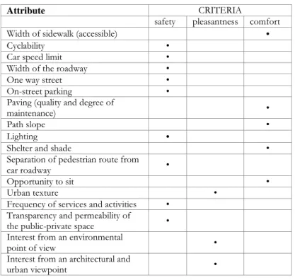
- A detailed characterization of every edge of the street network graph through 17 attributes describing the physical and functional features of the streets and its surrounding environment considered relevant for making the urban space attractive, safe, pleasant and comfortable for pedestrians.
15
Table 2. shows the attributes, their trade-offs defined by the CAWS model and the variables associated to each street edge. CAWS (Blečić, et al. (2015b; 2015)) defines trade-offs in a normative way by asking to a focus group composed by urban experts (urban designers, transport experts, policy makers) to define the importance of the attributes.
In this study, we started using the trade-offs of the original CAWS model, then we built personalized trade-offs for different groups of citizens and apply them in order to build decision maps attentive to citizen’s differences.
Table 2: Street network attributes considered in CAWS model. Blečić et al. (2015a; 2015b).
Attributes (𝜶) Trade-off (CAWS model)
Parameters
Width of sidewalk (accessible) 2/30 wide (0.8); comfortable (0.7); minimum (0.5); inadequate (0.3); lacking (0.1) Cyclability 2/30 exclusive lane (0.8); off-road lane (0.5); on.road lane (0.3); not possible/prohibited (0.1)
Car speed limit 2/30 pedestrian way (0.8); 20 Km/h (0.7); 30 Km/h (0.5); 50Km/h (0.3); 70 Km/h (0.1)
Width of the roadway 1/30 pedestrian way (0.8); one car lane (0.6); 2 car lanes (0.5); 3 car lanes (0.3); >3 car lane (0.1)
One way street 1/30 pedestrian way (0.8); yes (0.5); no (0.1)
On-street parking 1/30 prohibited parking (0.8); permitted (0.5); illegal parking (0.1)
Paving (quality and degree of
maintenance) 2/30 fine (0.8); cheap (0.5); bumpy (0.1)
Path slope 2/30 smooth (0.8); light (0.5); rise (0.1)
Lighting 1/16 excellent (0.8); good (0.6); inadequate (0.3); lacking (0.1)
Shelter and shade 1/16 strong (0.8); weak (0.5); lacking (0.1)
Separation of pedestrian route from
car roadway 2/30 marked/strong (0.8); weak (0.5); lacking (0.1)
Opportunity to sit 1/16 extended (0.8); thin (0.5); lacking (0.1)
Urban texture 1/16 dense (0.8); park or green space (0.6); low density (0.4); undeveloped land (0.1) Frequency of services and activities 1/16 abundant (0.8); somewhat (0.6); rare (0.3); no services/activities (0.1) Transparency and permeability of
the public-private space 1/16 integrated (0.8); filtered (0.5); separated (0.1)
Interest from an environmental
point of view 1/16
prevalence of pleasant elements (0.8); presence of a few pleasant elements (0.6); lack of pleasant or disturbance elements (0.4); presence of a few disturbance elements (0.2); prevalence of disturbance elements (0.1)
Interest from an architectural and
urban viewpoint 1/16
prevalence of pleasant elements (0.8); presence of a few pleasant elements (0.6); lack of pleasant or disturbance elements (0.4); presence of a few disturbance elements (0.2); prevalence of disturbance elements (0.1)
According to the CAWS model, we consider the street network as composed by a set of points 𝑌 offering opportunities in the city (i.e. green facilities, services, commerce):
𝑌 = {𝑦1⋯ 𝑦𝑖⋯ 𝑦𝑛} (1)
In the following we will use indices 𝑖, 𝑗 to indicate different points (departures or arrivals of any possible walk). We thus get a set of arcs 𝑋 connecting the set of points 𝑌:
16
Where 𝐶 ⊆ 𝑌 × 𝑌 is a binary relation representing the existence of a connection between two nodes. Finally, we have a set of paths 𝑃 that are a set of arcs connecting two nodes. The value function (for citizen 𝜒) 𝜛𝜒 for any path is a function aggregating the values of
all arcs being part of the path function of the arcs. Given a path 𝑝𝑙 ∈ 𝑃 we have:
𝜛𝜒(𝑝𝑙) = Ψ𝑥𝑖𝑗 ∈ 𝑝𝑙(𝑣𝜒(𝑥𝑖𝑗)) (3)
Where 𝑣𝜒 represents the value function for single arcs for citizen 𝜒. If we accept that the
value of each path is independent from the value of any subset of arcs, then we can use an additive function such that:
𝜛𝜒(𝑝𝑙) = ∑ 𝑣𝜒(𝑥𝑖𝑗) 𝑥𝑖𝑗∈𝑝𝑙
(4)
Then, we denote by 𝐷(𝑦𝑖) the set of all the destinations reachable from node 𝑦𝑖. We use
the variable 𝑧 for all such destinations and we denote as 𝑢𝑧 the utility received by visiting
𝑧 and by 𝑐𝑦𝑧 the cost afforded in order to reach 𝑧 (from 𝑦). We finally use the variable 𝑛𝑧
in order to indicate the number of times the destination 𝑧 can be reached. We define as walkability score of any node 𝑦𝑖 ∈ 𝑌 the solution of the following optimization problem:
𝑊𝑎𝑙𝑘𝑎𝑏𝑖𝑙𝑖𝑡𝑦 𝑆𝑐𝑜𝑟𝑒(𝑦) = max ( ∑ 𝑢(𝑧)𝑛𝑧𝑝 𝑧 ∈ 𝐷(𝑦) ) 1 𝜌 (5) Subject to ∑ 𝑐𝑦𝑧𝑛𝑧 ≤ 𝐾 𝑧 ∈ 𝐷(𝑦) (6)
Where 𝐾 is the available budget for walking to the various destinations and 𝜌 is a parameter representing the constant elasticity of substitution among destinations.
Considering that walking through an arc is evaluated by any user as an activity possibly rewarding, we consider a set of “rewarding attributes” 𝐴 = {𝛼1, ⋯ , 𝛼𝑚} (Table 2), we
denote the generic attribute as 𝛼𝑘 and we establish the trade-offs among such attributes as
𝑤𝑘 with
∑ 𝑤𝑘 = 1 𝑚
𝑘=1
(7)
According to equation 3, as specified in equation 4, given a path 𝑝𝑦𝑧 the cost of using the
17 𝑐(𝑦𝑧)= ∑ 𝑙𝑥𝑖𝑗 [ 1 − (∑ 𝑤𝑘(𝑣𝑘(𝛼𝑘(𝑥𝑖𝑗))) 𝑚 𝑘=1 𝜌 ) 1 𝜌 ] + 𝑐0 𝑥𝑖𝑗 ∈ 𝑝𝑦𝑧 (8)
Where 𝑐0 is a fixed cost, 𝑙𝑥𝑖𝑗 is the length of arc 𝑥𝑖𝑗, 𝑤𝑘 is the weight of the attribute 𝛼𝑘,
𝑣𝑘 is the value of the arc on the attribute 𝛼𝑘 and 𝜌 is a parameter representing the
elasticity of substitution among attributes.
The variable part of this expression yields unit cost of 1 when all attributes are at their minimum (i.e. 0) and approaches 0 when attributes approach the maximum (i.e. 1). In the CAWS algorithm all combined attributes have a specific importance (trade-off, see Table 2) assigned by rules defined according to the literature and advice of experts in urban planning and transport fields. In this sense it can be classified as a normative model of decision making based on an exogenous rationality and independent of pedestrians’ preferences.
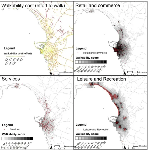
Finally, using a path-finding algorithm over graphs, the model searches for all the destinations reachable by foot from each node in the graph, correcting the plain geometric streets distances for walkability cost. More precisely, among many alternative paths from an origin to a destination in the street network, the model plugs the less costly (i.e. the one with the best combination of length and quality). Next, considering both the number of destinations and their walkability-corrected distances, the model assigns a walkability score (WS) to each node of the graph. These scores are then interpolated to finally obtain a map of distribution of capability-wise walkability in space. In Figure 4 we can see the maps of street costs and the maps of walkability generated by the Walkability Explorer software by using the CAWS model for the city of Alghero (Italy). The reader interested can found the map here. For more information on CAWS evaluation model see Blečić et al. (2015a; 2015b).
The resulting Walkability Score of each point in space, rather than indicating how much a specific place is in itself walkable, given its intrinsic place-specific characteristics (as in the majority of walkability evaluation methods and indicators), reflects where to and how a person can walk starting from that place; in other words, what is the walkability that a
specific location is endowed with.
This conceptualization of walkability provides the link with the capability approach and specifically with urban capabilities, for it takes into account both the opportunity sets (i.e. the number and variety of possible attractive destinations) distributed in urban space, as well as the quality of urban environment (specifically in terms of how it is conducive to walk) which is relevant for the relation people may entertain with their living environment.
However, in using this model we do not take into account the subjective value that different citizens may attribute to the arcs as a result of their personal values. In the following section we take care of this issue.
18
Figure 4: Street Cost and Walkability score for different types of opportunities (Services, Retail and Commerce, Leisure and Recreation) in a normative model.
6 Analysis of citizens’ values
6.1 Multiple Criteria Analysis of preferences
This phase (see Figure 2) aims to define citizens’ value functions with respect to the attributes that describe the street environment. Each citizen is considered as a decision maker choosing the best walkable areas in Alghero city with respect to his environmental preferences and needs. Among the possible walkable areas, we are interested in inspecting such areas that fit the needs and values of walkers: what he\she can freely choose to access by walking being influenced by the urban environment and his\her personal characteristics. The analysis of space can be then intended as a multiple criteria decision-making problem that aims to rank a set of finite alternatives, i.e. all the possible streets offered by the city and valued as walkable by the individuals.
We learned preferences through a choice experiment (Arnberger & Eder, 2011; Guo & Loo, 2013) (see paragraph 4) and we chose to analyse results with the Additive Utility Functions (UTA) family of methods (Jacquet-Lagreze & Siskos, 1982; Keeney & Raiffa,
19
1976). UTA is a family of multi-criteria decision analysis methods aimed to evaluate alternatives thanks to a set of value functions adopting the preference disaggregation principle: obtain global preference statements upon a set of choice examples and then infer the value functions that better fit such statements. UTA was originally proposed by Jacquet-Lagreze & Siskos (1982) and then developed in different forms (Greco, Kadziński, Mousseau, & Słowiński, 2012; Kadziński, Greco, & Słowiński, 2012; Siskos, Grigoroudis, & Matsatsinis, 2005). The method builds a set of additive value functions from a ranking on a reference set A given by the decision maker. It uses linear programming in order to estimate the family of utility functions with the minimum possible error and to compute the optimal set of functions as consistent as possible with the given preferences. In synthesis, UTA method disaggregates the preferences of the decision maker but finally allows a complete evaluation of the problem. Such a method assumes the commensurability among citizens’ values and allows to compare and group similar values, a known problem that affects the public policies having to deal with multiple stakeholders.
The criteria aggregation model in UTA is an additive value function (Jacquet-Lagreze & Siskos, 1982):
𝑢(𝑥) = ∑ 𝑝𝑖𝑢𝑖(𝑥) 𝑛
𝑖=1
(9)
where ui , i = 1, 2, . . . , n are non-decreasing real valued functions, named marginal
value or utility functions, which are normalized between 0 and 1, and pi represents the
trade-offs among the criteria that define u.
This method was used in decision aiding for different multiple criteria problems and in the environmental field for the evaluation of projects (Greco et al., 2012; Kadziński et al., 2012; Siskos, 1983; Siskos & Assimakopoulos, 1989). Here we propose to use this family of methods in order to analyse citizens’ values in a way that represents citizens’ preferences to walk.
According to this method, we represent the preference relations ⪰𝜒 for individual 𝜒
among the set of street arcs using additive value functions. Let 𝑣𝜒 denotes the value
function of individual 𝜒. We define ⪰𝜒 from 𝑣𝜒as follows:
𝑥𝑙𝑚⪰𝜒 𝑥𝑛𝑡 𝑖𝑓𝑓 𝑣𝜒(𝑥𝑙𝑚 ) ⪰ 𝑣𝜒(𝑥𝑛𝑡 ) (10)
Where xlm and xnt represent two street arcs and 𝑣𝜒 represents the utility of a street arc for
the individual 𝜒. We assume that the utility 𝑢 of the individual 𝜒 can be represented as a weighted sum of marginal value functions (for a given street edge 𝑥𝑖𝑗):
𝑢𝜒(𝑥𝑖𝑗) = ∑ 𝑤𝑘𝑣𝑘(𝑥𝑖𝑗) 𝑘∈𝐴
(11)
where 𝑤𝑘 ∈ [0, 1] represents the trade-off of the attribute 𝑘 (among attributes within the
set 𝐴 that describe the street) for the individual 𝜒. Moreover, given a street attribute 𝑘 ∈ 𝐴, we define a marginal value function 𝑣𝑘: 𝑅+→ [0, 1].
We assumed for now that such marginal value functions 𝑣𝑘 and the trade-offs may
20
function 𝑣𝑘(𝑥𝑖𝑗) represents the utility we assumed the individual 𝜒 give to walk in a
street 𝑥𝑖𝑗 with an attribute k having a specific feature (for example: to walk in a street
with a large sidewalk). We defined each partial value function 𝑣 as a two linear piecewise increasing function representing the importance that each citizen gives to the different attributes of the street with reference to the benefit to traverse that street.
This phase consents to estimate the value functions with reference to the attributes of the street network and to define the trade-offs among the features that describes the walkability of the street network. For example, Figure 5 represents the partial value functions of a hypothetical individual. We can see that the attributes “lighting” and “environmental interest” are the most important in a street with a high walkability benefit (utility).
Considering this utility, we can calculate the cost (see section 5), in terms of effort that a specific individual 𝜒 has to bear in order to walk such street with the equation (8) that we modify as follows. 𝑐(𝑦𝑧)= ∑ 𝑙(𝑥𝑖𝑗) [ 1 − (∑ 𝑤𝑘(𝑣𝑘(𝑥𝑖𝑗)) 𝑚 𝑘=1 𝜌 ) 1 𝜌 ] + 𝑐0 𝑥𝑖𝑗 ∈ 𝑝𝑦𝑧 (12)
Our objective is thus to obtain the cost, i.e. effort to walk in a street network with respect to the utility that a citizen can benefit considering his preferences.
The value function 𝑣 of the individual 𝜒 becomes:
𝑣𝜒(𝑥𝑖𝑗) = ∑ 𝑤𝑘(𝑣𝑘(𝑥𝑖𝑗)) 𝑚
𝑘=1
(13)
Where 𝑤𝑘 is the trade-off of the 𝑘 attribute for the individual 𝜒, 𝑣𝑘 is the marginal value of the attribute 𝑘 for the arc 𝑥𝑖𝑗.
21
6.2 Classification of citizens’ preferences.
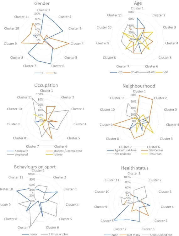
This phase is aimed to group individuals by considering both their socioeconomic factors and their value function attributes. For this purpose, we need to select the socioeconomic factors (gender, age, profession, health status...) that influence the evaluation of the street network by the individuals. The objective is to establish the minimal set of socioeconomic and behavioural features useful in order to group citizens in clusters (Qamar & Keane, 2012). To achieve this, we made a rough set feature selection analysis (Jensen & Shen, 2007; Pawlak, 1982) that simplify the original set of socioeconomic and behavioural features that affect the choice to walk by reducing the number of unnecessary features albeit retaining accuracy. The original set of features was composed by socioeconomic (age, sex, job,…) and behavioural factors (sport and leisure behaviours and activity-based behaviours) collected through the questionnaire. The rough set analysis feature selection suggested a feature subset composed of 9 socioeconomic and behavioural attributes (instead of 14) that have to be considered for the cluster analysis: (1) sport routine, (2) work/study routine of walking, (3) free time routine of walking, (4) errands routine, (5) health status, (6) sex, (7) age, (8) job, (9) neighbourhood of residence. Then, we performed a cluster analysis of the values of value functions together with these 9 factors. Cluster analysis consents us to identify groups of citizens which give the same importance to the streets’ attributes and have similar socioeconomic and behavioural profile.
We chose to calculate clusters with the Hierarchical Cluster (HC) method (by using the R software) which consents to calculate clusters without knowing a-priori the number of groups. Having to deal with numerical (value functions) and categorical data (socioeconomic and behavioural information), we used the Gower dissimilarity index (Gower, 1971), suggested in such cases in order to define distances and centroids. The Gower index calculates for each variable a distance metric fitting that type of variable, then the distance is scaled between 0 and 1 (normalised scale with quantitative data and dummy variables for nominal data). The distance matrix is calculated using a linear combination with user-specified weights (an average).
Finally, in order to generate groups, we chose the Ward (1963) classification method that minimizes the total within-cluster variance. Among the cluster agglomeration methods Ward is considered one of the more appropriate for the unsupervised classification as it merges at each step the pair of clusters with minimum between-cluster distance.
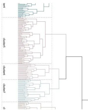
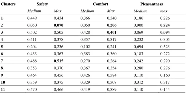
Cluster analysis silhouette index suggested us to classify the population into 11 clusters, represented in Errore. L'origine riferimento non è stata trovata. with different colours. Cluster dendrogram (Figure 5) shows the order in which clusters are joined: the x axis represented the closeness of individuals in the same cluster, while the height of the dendrogram indicates the dissimilarity between clusters.
The citizens composing these 11 clusters vary and differ from the traditional statistical classifications of people by age and gender. In brief, the cluster analysis consents to group different categories of people considering both their preferences and needs; needs are represented by socioeconomic factors while preferences are learnt by value functions. In order to discuss the results with a hypothetical decision maker, we proposed to synthesise the value functions of the single 17 attributes (Table 1) into three criteria (safety, comfort, pleasantness) defined according to the walkability literature (Blečić, Congiu, et al., 2020) and considering the specificity of our case study. The hypothesis here is that a potential client of such a study should be able to see each cluster
22
characterized by these three criteria (which are easily perceived). This synthesis is visible in Table 4 and is done aggregating linearly the values. This is possible because of the separability and independence of the 17 basic attributes. 𝛼𝑗 ∈ 𝐴.
We use an example with two attributes of the street for demonstrating that these two conditions (separability and independence) are satisfied: one coming from our model and another external and not included in our model. The “width of the sidewalk” is a separable attribute because if we consider two street edges, 𝐾 and 𝐻, having identical variables with respect to the walkability attributes 𝛼𝑗 ∈ 𝐴 except sidewalk width, we can
assert that 𝐾 is preferred to 𝐻 only because the sidewalk of the street 𝐾 is larger than the sidewalk of the street 𝐻.
On the contrary, if we consider the attribute “number of vehicle entrance” (not included in our model) we can show that such attribute is not separable. For example, two street edges 𝐾 and 𝐻 having identical variables with respect to the walkability attributes 𝛼𝑖,…,𝑗 ∈ 𝐴 except 𝑛. 𝑉𝑒ℎ𝑖𝑐𝑙𝑒 𝑒𝑛𝑡𝑟𝑎𝑛𝑐𝑒 ∉ 𝐴 , we can assert that 𝐾 is indifferent to 𝐻 even
if the number of vehicle entrance of the street 𝐾 is different from the number of vehicle entrance of the street 𝐻.
The synthesis of attributes into criteria (such as those used in this paper: safety, comfort and pleasantness in Errore. L'origine riferimento non è stata trovata.), serves the purpose of giving priorities to certain goals revealed during the discussion with the decision makers and aims to prioritize the improvement of specific features (i. e. the attributes: width of the sidewalk, paving, …) in the design of a public policy. This methodological choice corresponds to a degree of freedom between the analyst and the decision maker giving more legitimation to the decision process.
Table 3: Criteria of walkability and related combining attributes.
Attribute CRITERIA
safety pleasantness comfort
Width of sidewalk (accessible) •
Cyclability •
Car speed limit •
Width of the roadway •
One way street •
On-street parking •
Paving (quality and degree of
maintenance) •
Path slope •
Lighting •
Shelter and shade •
Separation of pedestrian route from
car roadway •
Opportunity to sit •
Urban texture •
Frequency of services and activities •
Transparency and permeability of
the public-private space •
Interest from an environmental
point of view •
Interest from an architectural and
23