26
‘‘CONCAVE ISLANDS’’: HABITAT HETEROGENEITY OF PARAFLUVIAL PONDS
IN A GRAVEL-BED RIVER
Ute Karaus1, Laurenz Alder, and Klement Tockner
Department of Limnology
Swiss Federal Institute for Environmental Science and Technology (EAWAG) Ueberlandstrasse 133
8600 Duebendorf, Switzerland
1Present address:
Ute Karaus
Department of Limnology, EAWAG/ETH P.O. Box 611
8600 Duebendorf, Switzerland E-mail: ute.karaus@eawag.ch
Abstract: Floodplain pond distribution, density, and diversity were investigated along the active river cor-ridor of the Tagliamento River in northeastern Italy, the last major semi-natural river in Central Europe. Along the corridor, ponds peaked in bar- and island-braided floodplains but were absent in constrained
sections. Within the main study area, a 1.0-km2 large braided floodplain, the number of ponds containing
water ranged between 18 and 39 depending on the water level in the main channel. Thermal properties and water-level fluctuations were the most important variables determining pond characteristics and heteroge-neity. Results from a PCA on environmental variables distinguished four groups of ponds distributed along a hydrologic and thermal gradient. Parafluvial ponds are short-lived, discrete, aquatic ‘‘islands’’ within the floodplain matrix. They are expected to contribute disproportionately to aquatic biodiversity; however, they are very sensitive landscape elements that disappear as a consequence of river regulation, wood removal, and flow control.
Key Words: reference river, braided, restoration, biodiversity, riparian, patch dynamics
INTRODUCTION
Riparian corridors are characterized by a large di-versity of aquatic and terrestrial landscape elements (Ward et al. 2002). Surface waters include lotic, semi-lotic, and lentic water bodies distributed along an in-undation continuum. Cut-and-fill alluviation, coupled with ground- and surface-water interactions, create a complex array of shallow lentic habitats, including floodplain ponds. While lentic water bodies such as vernal ponds, forested wetland ponds, prairie ponds, man-constructed ponds, and small lakes have been ex-tensively studied (Batzer et al. 1999, Schwartz and Jenkins 2000, Bro¨nmark and Hansson 2002, Brooks and Hayahi 2002, Oertli et al. 2002), alluvial ponds have been almost completely ignored (Drago 1989, Homes et al. 1999).
Ponds are important for biodiversity conservation, but they have been lost on a large scale during the twentieth century, reaching 40–90% for Western Eu-ropean countries and for the U.S.A. (Hull 1997, Mitsch and Gosselink 2000, Wood et al. 2003). Ponds in
dy-namic floodplains are among the most endangered landscape elements since they disappear rapidly as a consequence of river regulation (Homes et al. 1999, Gurnell and Petts 2002, Ward et al. 2002). Ecologi-cally, floodplain ponds can be viewed as ‘‘concave islands’’ that are embedded into the alluvial floodplain matrix (cf. Holland and Jain 1981).
The main objectives of the present study were to characterize the environmental conditions of alluvial ponds and to quantify their physicochemical hetero-geneity. Our focus was on parafluvial (sensu Fisher et al. 1998) ponds within the active zone of the river corridor and the riparian forest ponds. We recognized three main questions. (1) Where do ponds peak in number along the corridor? (2) How are pond density and pond area related to river hydrology? (3) Which environmental variables explain pond diversity within the active plain? The semi-natural Tagliamento River in northeastern Italy offers the rare opportunity to study the density, diversity, and dynamics of paraflu-vial ponds under near-natural conditions (Tockner et al. 2003).
Figure 1. The catchment of the Tagliamento and the location of study sites. I⫽ Italy, SL ⫽ Slovenia, A ⫽ Austria. Numbers (1–17) stand for the study segments of the longitudinal survey.
STUDY AREA
The Tagliamento is a large, gravel-bed river located in northeastern Italy (Friuli-Venezia Giulia; 46⬚N, 12⬚30⬘E; Figure 1). The river originates at 1195 m a.s.l. in the Carnian Alps and flows 170 km to the Adriatic Sea. The catchment covers 2580 km2, with
more than 70% of its catchment located in the Alps. The mountainous part of the catchment consists of limestone and Flysch deposits, and the Friulian plain is filled with Tertiary and Quaternary sediments (Petts et al. 2000, Tockner et al. 2003). The riparian corridor consists of five major landscape elements: surface wa-ter (12.4 km2), bare gravel (38.7 km2), vegetated
is-lands (10.6 km2), riparian forest (32.0 km2), and
to-pographical low areas that are not forested (⬃50-km2,
Tockner et al. 2003). The Tagliamento has an average
discharge of ⬃70 m3s⫺1, whereas floods with 2-, 5-,
and 10-yr recurrence intervals are estimated to be 1100, 1600, and 2150 m3s⫺1 (Petts et al. 2000). High
flow is caused by snowmelt (spring) and by heavy rainfall (autumn), with discharge maxima of ⬃4000 m3s⫺1(Ward et al. 1999). The near-natural
morpholog-ical character of the Tagliamento is reflected by a com-plex channel morphology structured by a dynamic hy-drologic flood regime, an idealized longitudinal se-quence of constrained, braided, and meandering sec-tions, and low human impacts. In the braided section, the active plain is up to 1.5 km wide and characterized by a variable cover of vegetated islands (Petts et al. 2000, Arscott 2001, Gurnell et al. 2001, Van der Nat et al. 2002).
middle section of the river corridor (Figure 1; river kilometer 79.8–80.8; 135 m a.s.l.). It consists of lotic and lentic water bodies (ponds), gravel bars, wooded islands, and a fringing riparian forest. The local cli-mate has an Alpine character, with much precipitation (2000 mm yr⫺1at Gemona at 215 m a.s.l., 1961–1990)
and a mean maximum air temperature of 17.6⬚C. De-tailed information on the catchment and the main study area are given by Ward et al. (1999), Arscott et al. (2000), Gurnell at al. (2000), and Tockner et al. (2003).
METHODS
In the present study, we defined ponds as isolated water bodies with a surface area ⬎2 m2 and a water
depth ⬎10 cm. Hydrologically, ponds were divided into three categories: permanent, ephemeral, and epi-sodic. Permanent ponds carried water during the entire investigation period, ephemeral ponds dried up for some periods, and episodic ponds had surface water only during short–term flow or flood pulses (sensu Tockner et al. 2000).
Pond Dynamics in Space and Time
In spring 2002, around mean water level, pond den-sity was systematically investigated within 17 seg-ments of 1-km length; equally spaced (every 10 km) along the entire corridor (Figure 1; see also Karrenberg et al. 2003). Within each segment, all ponds were mapped.
Between April and October 2001, all ponds in the main study area were repeatedly mapped (total 46 dates). In addition to all ponds in the active zone, we included ponds in the adjacent riparian forest (right bank, in flow direction). The interval between individ-ual sampling dates ranged from 3 to 12 days depend-ing on the relative change of the water level (main channel). The exact position, area, and distance to veg-etated islands, main channel, and side channel were measured for each pond using a Global Positioning System (GPS, TCS 1, Trimble Inc., USA). On each sampling date, shape, length, width, and maximum depth were determined for all ponds that actually con-tained water. The surface area of each pond was cal-culated during filling and drying periods by multiply-ing maximum length and maximum width. Further-more, the degree of surface connectivity of individual pond with channels was recorded.
Pond Hydrology
Water level was determined by installing simple graduated staff gauges vertically at the deepest point
of each floodplain pond. Staff gauges were read man-ually at each sampling date (totaling 46 dates). A per-manent gauging station at a knick point 1.5-km down-stream of our investigation site (location name: S. Pie-tro) was used as a reference point in the main channel. Stage data were used rather than discharge because discharge data were not available for the investigation period. A problem using stage data from a morpho-logically dynamic river is that channel bed elevations change frequently; these changes could affect the stage discharge relationship. The gauging station from which the data were obtained is located at a stable bedrock constriction and therefore minimized instabil-ity in the stage discharge relationship. Daily changes and cumulative water-level fluctuations (sum of daily change) were calculated for each pond.
Thermal Heterogeneity
From April to October 2001, surface-water temper-ature was recorded at hourly intervals. Tempertemper-ature data-loggers (VEMCO Minilog, Nova Scotia, Canada) were installed at the deepest point of each pond (Ar-scott et al. 2001, Uehlinger et al. 2003). The following variables were calculated to characterize thermal het-erogeneity: (i) average daily temperature, (ii) average minimum daily temperature, (iii) diel temperature am-plitude (maximum ⫺ minimum difference), (iv) sea-sonal variation expressed as the difference between minimum and maximum values during the investiga-tion period, and (v) cumulative degree days (sum of daily mean temperature).
Physicochemical Characterization
Oxygen (mg/l, % saturation) was measured with a portable oximeter (Oxi 320, WTW, Germany), pH with a portable pH meter (pH 340, WTW, Germany), turbidity (Nephelometric Turbidity Units: NTUs) with a portable turbidity meter (Cosmos, Zu¨llig, Switzer-land), and specific conductance (S cm⫺1, T
refat 20⬚C)
with a portable specific conductance meter (LF 325, WTW, Germany). All ponds were sampled between 8:00 and 11:00 a.m. at the central part of the pond to minimize diel influences (at the location of tempera-ture loggers).
Statistical Analyses
Synchrony was used to assess the seasonal patterns in pond dynamics. Synchrony or temporal coherence is a measure of the similarity between a pair of sam-pling sites (e.g., Soranno et al. 1999, Kling et al. 2000, Tockner et al. 2002). High synchrony is generated when sites respond similarly to a common driver. For
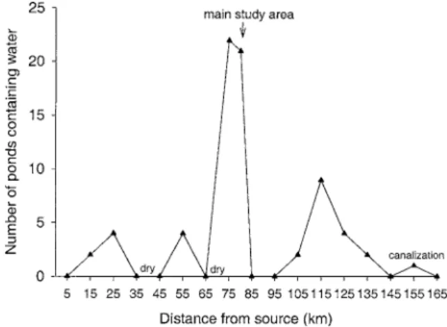
Figure 2. Number of ponds containing water per river-km along the Tagliamento corridor (April 2002).
each variable, synchrony was calculated as the Pearson product-moment correlation coefficient (r) between time series of all data (n⫽ 46) for each pair of ponds. In order to classify individual pond types, a principal components analysis (PCA; CANOCO 4.02, Ter Braak and Smilauer 1998) was applied by integrating mor-phological, physicochemical, and hydrologic variables. To reflect the within- and between-pond heterogeneity, we used ranges (maximum ⫺ minimum differences) for turbidity, water-level fluctuation, specific conduc-tance, oxygen, and pH.
RESULTS Pond Dynamics in Space and Time
Along the active river corridor, density ranged from 0 to 22 ponds per 1-km study segment, with greatest pond density in bar- and island-braided floodplain seg-ments (Figure 2). In 8 out of 17 segseg-ments, ponds were absent during the sampling campaign, either because there was no surface flow or because the segment was constrained naturally (canyon sections) or artificially (canalization in the most downstream sections, Figure 2).
Of the 39 ponds in the main study area, 18 were permanent, 18 ephemeral, and 3 episodic (Figure 3). Based on their location, 31% of all ponds were asso-ciated with vegetated islands, and 61% were bare-gravel ponds, the latter mostly associated with large wood accumulations. Three permanent ponds (8%) were located in the riparian forest. Pond shape was from near circular to extremely elongated, with length-to-width ratios ranging from 1.1 to 23.3.
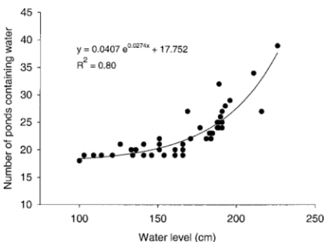
Pond density increased exponentially from 18 ponds at a water level of 100 cm to 39 ponds at 230 cm (Figure 4). At a specific water level, the density of ponds varied considerably. For example, at a water level of 190 cm, pond density in the main study area
ranged from 24 (1 May) to 32 (23 April). Based on the observed relationship between water level and pond density, an entire year of water-level data were converted into a time series of pond densities (Figure 5). As expected from this relationship, pond density strongly resembled the dynamic hydrograph, with an expected peak at⬃250 cm, close to the maximum wa-ter level sampled during the present study. However, a sharp decrease in density was observed above a wa-ter level of ⬃250 cm (U. Karaus, personal observa-tion). At this water level, around 50% of the floodplain is inundated (Van der Nat et al. 2002). Based on this prediction, about 50% of all ponds contained water only during short periods, often only for 1–2 days after flood events (Figure 5).
The aquatic surface area of all ponds combined in-creased exponentially from 1503 m2at low water level
to 18204 m2 at 216 cm (y ⫽ 113.3 e0.022x, r2 ⫽ 0.92).
Area of the smallest permanent pond (39) was 3 m2at
lowest measured water level and 48 m2at highest
wa-ter level. Pond 92 was the largest pond at lowest wawa-ter level (618 m2). At highest measured water level, pond
82 was the largest pond (7965 m2). The area ratio of
high to low water level (Ahigh/Alow; Table 1) ranged
from 2 (pond 33) to 470 (pond 82).
Pond Hydrology
During the investigation period, the maximum change in water level ranged from 11 cm (pond 93) to 72 cm (pond 84), compared to 116 cm in the main channel (Figure 6). Cumulative water-level change (sum of daily changes during the investigation period) ranged from 56 cm (pond 93) to 311 cm (pond 94), compared to 348 cm in the main channel. A distinct hydrologic gradient occurred across the floodplain. Ponds close to the right bank (in flow direction) had small water-level fluctuations, ponds close to the main channel and ponds located in former channels (ponds 82, 79) showed large amplitudes (Figure 6). Water-level fluctuations in all permanent ponds except pond 102 were strongly related to the hydrograph of the main channel (r⬎ 0.5). Pond 102 had a very constant water level.
At low water level (100 cm), 54% of the ponds were dry and 46% remained disconnected. At mean water level (189 cm), 31% were dry, 64% remained discon-nected, and 5% were already connected. At about 340 cm, all water bodies (ponds and channels) merged into a single channel (Figure 7).
Thermal Heterogeneity
Over the 6-month period (May to October 2001), cumulative degree-days were from 1924⬚C (pond 102)
Figure 3. Map of the main study area and location of permanent, ephemeral, and episodic ponds. In the active corridor, only ponds within the large gravel bar / island complex were considered. Ponds 100 to 102 are in the riparian forest.
Figure 4. Relationship between water level of the main
channel (S. Pietro) and the number of ponds containing wa-ter.
to 3308⬚C (pond 87). Across the floodplain, average daily temperature difference between the coolest and the warmest pond ranged from 4.0⬚C to 16.1⬚C, with an average difference of 9.8⬚C. Within individual ponds, average daily temperature (May until October) ranged from 13.4⬚C (pond 102) to 22⬚C (pond 92), and average diel amplitude was from 0.9⬚C (pond 102) to 11.6⬚C (pond 92). Maximum diel amplitude was be-tween 1.3⬚C (pond 102) and 26.2⬚C (pond 39). Indi-vidual ponds can be arranged across a gradient from small to large diel and seasonal amplitudes (Figure 8). Diel and seasonal temperature patterns (based on hour-ly measurements) illustrate differences in thermal re-gimes across the floodplain (Figure 9). Pond 33, for example, had low diel variation but a distinct seasonal variation. A similar seasonal variation, but with larger daily fluctuations, was observed in pond 36A. Distinct diel temperature fluctuations were measured in ponds
Figure 5. A: Water level (S. Pietro) from May 2001 to June 2002. B: Number of ponds predicted from the water level— pond number relationship (see Figure 4) for this time period.
Table 1. Area (m2) of selected floodplain ponds at low water level
(Alow; 103 cm) and high water level (Ahigh; 216 cm), and area
variation (ratio Ahigh/Alow).
Pond Alow Ahigh Ahigh/Alow
3A 33 36A 39 79 36 173 6 3 289 239 408 85 48 2718 7 2 15 16 9 80 81 82 84 87 5 63 17 70 39 86 165 7965 321 150 18 3 469 5 4 92 94 98 98A 618 17 167 0 (dry) 4343 268 1345 64 7 16 8 ⬎64
Figure 6. Relative daily water-level changes (cm) of all permanent ponds compared to the main channel (MC) during the
investigation period. Ponds are grouped according to the outcome of the PCA (see Figure 10).
88, 90, 92, and 94. Small temperature fluctuations at the beginning of the investigation period and a contin-uous increase during the investigation period were fea-tured in pond 90. A weak seasonal temperature pattern was shown in ponds 98 and 102.
Classification of Ponds
Average synchrony for all variables was 0.33. This average was taken across all pairs of ponds. Synchrony of individual ponds with all other ponds was low and ranged from 0.21 (pond 100) to 0.47 (pond 84). Syn-chrony between individual ponds and the lotic channel
Figure 7. The shift of ponds from a dry (white) to a dis-connected lentic (gray) and finally to a dis-connected (black) state with increasing water level in the main channel (S. Pietro). Data from the water level 256 cm are obtained from a preliminary sampling in March 2001.
Figure 8. Average daily temperature (May until October
2001) vs. diel amplitude for all permanent ponds (r2⫽ 0.58).
ranged from 0.15 (pond 15) to 0.53 (pond 53). Syn-chrony of variables was 0.18 for turbidity, 0.22 for specific conductance, 0.42 for pH, and 0.50 for dis-solved oxygen.
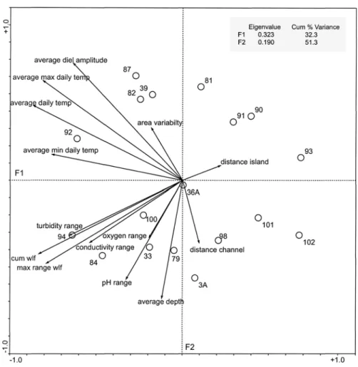
The first two axes of the principal components anal-ysis PCA explained 51% of the total variance within the data matrix (14 environmental variables, 18 per-manent ponds). Average, maximum, and minimum daily temperature (73%, 64%, and 56%), water-level fluctuation (67%), turbidity (42%), and specific con-ductance (28%) accounted for the definition of the F1 axis (Figure 10). Average water depth (45%), average diel temperature amplitude (45%), and pH (31%)
ac-counted for most of the definition of the F2 axis. Dis-tance to channel and island (69 and 46%) and vari-ability in surface area (40%) accounted for the defi-nition of the F3 axis (not shown in Figure 10). Oxygen (77%) explained the F4 axis (not shown). Results from the PCA on these environmental variables distin-guished four groups of ponds along the F1 and F2 axis (Figure 10). Group 1 (39, 82, 87, and 92; see Figure 3 for location) was characterized by a large thermal heterogeneity. In contrast, group 2 (3A, 93, 98, 101, 102) had a very low thermal heterogeneity. Group 3 (33, 79, 84, 94, 100) was hydrologically very dynamic and had a wide range in specific conductance, turbid-ity, pH, and oxygen values. Group 4 (81, 90, 91, 93) had small water-level fluctuations and showed a nar-row range in specific conductance, turbidity, pH, and oxygen values. Pond 36A did not fit into any of the groups.
DISCUSSION
The Tagliamento River offers the rare opportunity to investigate ecosystem patterns and processes under semi-natural conditions that can be studied almost no-where else in Europe (Ward et al. 1999). The Taglia-mento has a number of attributes that have not been given due consideration in river ecology: (i) an im-mense corridor of more than 150 km2, (ii)
uncon-strained floodplain segments, and (iii) a large number of vegetated islands (Tockner et al. 2003). A high di-versity of parafluvial ponds is considered as an addi-tional key attribute along the dynamic river corridor that has not yet been studied in detail.
Pond Dynamics in Space and Time
Along the active corridor of the Tagliamento, a maximum of 22 ponds per river-km was quantified
Figure 9. Hourly values of surface temperature in eight selected ponds (April to October 2001).
(Figure 2). Ponds were absent in human-controlled sections. Therefore, ponds can be considered as very sensitive aquatic habitats that disappear rapidly as a consequence of human impacts such as canalization or flow control. Along the Isar River (Germany), inten-sive hydrologic engineering has also led to a major
decrease in pond density and heterogeneity (Homes et al. 1999).
Besides human impacts, changes in the hydrologic and geo-morphological style along the river corridor control pond density and diversity. In the headwater section, a narrow floodplain, a steep channel slope
Figure 10. Principal components analysis ordination based on fourteen environmental variables for the ponds. Circles with numbers represent ponds and arrows indicate different variables. The ordination map illustrates the relationship of each variable with the definition of either the F1 or F2 axis and of each sampling point (pond) with respect to the F1 and F2 axes (defined
by the variables). Average max daily temp⫽ average maximum daily temperature; average min daily temp ⫽ average minimum
daily temperature; average daily temp⫽ average daily temperature; cum wlf ⫽ cumulative water-level fluctuation; max range
wlf⫽ maximum range of water-level fluctuation.
with coarse sediments, and a low alluvial reservoir limit the formation of ponds. An increase in active floodplain width, higher flow rates favor the formation of floodplain ponds in the middle or braided sections. In the meandering section, an increase of the active channel width combined with a narrow active flood-plain corridor, and a higher alluvium results in the for-mation of fewer but larger ponds (Arscott et al. 2000). Parafluvial ponds differ from woodland ponds, marshy ponds, or prairie ponds. They are very young habitats that are formed and shaped by repeated cut-and-fill processes (Kohler et al. 1999, Arscott et al. 2002). Indeed, ponds are among the youngest habitats in the Tagliamento channel, with average half-life ex-pectancies of less than seven months (Van der Nat et al. 2003). Gravel deposition, as well as erosion, is re-sponsible for the low half-life expectancies of ponds. Hydrologically, parafluvial ponds are closely linked to the main channel. Therefore, water-level fluctuations
in the main channel control the number and areal ex-tent of ponds (Figure 5). In the Tagliamento flood-plain, an exponential relationship between water level and pond density has been observed (Figure 4). There-fore, even moderate flow fluctuations can have major consequences for both pond density and area.
Pond Hydrology and Thermal Heterogeneity
The two most important factors that control pond diversity are hydrology (source and pathway of water) and temperature (see Figure 10). Hydrologic and ther-mal differences among ponds can be explained by a combination of flow paths (alluvial and hill-slope ground water), pond location (shading, distance to the channel), and topography (ratio of low-to-high water surface area). For example, a decreasing trend in flow variability from the main channel towards the riparian forest was observed. The ‘‘forest ponds’’ (e.g., 102),
which were almost completely shaded, deep, and fed by hill-slope ground water, had almost no water-level fluctuations.
The variability of water level affects area, which again influences surface connectivity (lateral connec-tivity) between ponds and the channel. Water-level fluctuation, topography, and spatial location of each pond create a heterogeneous pattern of connectivity (Figure 7). During low water level, most ponds are disconnected and expected to function ecologically as (concave) islands. Flood events connect the islands with the river and support the exchange of matter and organisms between lotic and lentic habitats (Drago 1989), a primary factor for ecosystem dynamics and functioning. Connectivity influences, for example, di-versity and productivity across different hierarchical scales (Amoros and Roux 1988, Ward and Stanford 1995, Stanford et al. 1996, Tockner et al. 1999, Ward et al. 1999). Hydrologic connectivity, which includes longitudinal, lateral, vertical, and temporal connectiv-ity, as well as complex habitat gradients, are strongly related to high species and life-history-strategy diver-sity (Amoros and Bornette 2002).
The second most important factor controlling pond diversity is temperature. The investigated ponds pro-vided a diverse array of warm and cold water patches within the active floodplain. In addition to longitudinal patterns in water temperature, lateral (e.g., ponds, backwaters) and vertical (e.g., within the substrate) heterogeneity in temperature is increasingly recog-nized as a potentially important aspect in habitat con-ditions in streams and rivers (Poole and Berman 2001, Arscott et al. 2002, Claret et al. 2002). In the main study area, a lateral thermal difference of up to 17⬚C at a specific day is as high as along the entire 170-km long river corridor (Arscott et al. 2001). Temperature is a primary factor that regulates ecosystem processes and therefore structures biotic communities (Ward and Stanford 1982, Ward 1992). It has a strong influence on life history, species diversity, and abundance levels (Ward and Stanford 1982).
Pond Heterogeneity and Ecological Role
Floodplain ponds had a wide range in size, shape, and physicochemical properties. An average synchro-ny among ponds of 0.33 indicates a low temporal co-herence of ponds to a common driver (water source, flow path, temperature). Furthermore, the low average synchrony value between ponds and the lotic channel (0.31) indicates that physicochemical parameters are strongly influenced by local factors such as the topo-graphic position of ponds, morphology, and their sub-surface connectivity (i.e., ground-water exchanges). An example of local influences was demonstrated
us-ing the relationships with specific conductance, which can be used as an indicator of hydrologic connectivity. In instances where specific conductance correlated poorly between ponds and side channel, while water-level fluctuation between ponds and the main channel were highly correlated, the interpretation suggests hy-drostatic effects, which indicate a hyhy-drostatic water connection but no water exchange between ponds and channels.
The morphological, topographical, hydrologic, ther-mal, and physicochemical heterogeneity, which is strongly related to the local environment of each pond leads to a unique pond mosaic (Figure 10). Floodplain ponds are responsible for much of the variation in chemical conditions and thermal variability across the floodplain (Arscott et al. 2000). In contrast, they only cover a tiny portion of total aquatic surface area. In the main study area of the Tagliamento, for example, ponds contribute ⬃6.0% of the total aquatic surface area at low water level and⬍1.0% at high water level (Van der Nat 2002). Despite this small aerial extent, ponds are expected to play a crucial ecological role. Floodplain ponds can provide habitat for a specific fauna and flora as demonstrated in recent investiga-tions along the Isar (Germany, Homes et al. 1999), in the Luznize floodplain (Czech Republic, Pechar et al. 1996), along the Ain and Rhoˆne Rivers (France, Cas-tella et al. 1991), or along the Flathead River (Mon-tana, J.A. Stanford and M. Lorang, pers. comm.). The faunal community composition depends on pond age (Schneider and Frost 1996), the frequency of flooding and drying (Castella 1987), on area and spatial ar-rangement within the landscape (Bro¨ nmark 1985, Ward and Blaustein 1994, Oertli 2002), on depth and width (Amoros 2001), and on the frequency, duration, magnitude, and timing of flooding and drying (Brooks 2000). This supports our assumption that each pond has an insular nature (‘‘concave island’’) with a char-acteristic set of environmental properties. Lastly, many ponds are associated with vegetated islands. Indeed, the presence of vegetated islands enhances the diver-sity of aquatic habitats (Arscott et al. 2000, Gurnell et al. 2001, Gurnell and Petts 2002). Therefore, ponds are expected to contribute to a greater invertebrate di-versity within the active floodplain channel.
CONCLUSIONS
The present study characterized and quantified the spatiotemporal dynamic that characterizes parafluvial ponds. Basically, all ponds are strongly related to the hydrologic regime of the channel. However, the mor-phology, topography, and the physicochemical prop-erties of each pond form a heterogeneous pattern in space and time. Thereby, each pond contributes to the
overall habitat diversity of the floodplain. The longi-tudinal investigation not only showed ponds as part of the corridor, but also emphasized the sensitivity of ponds to anthropogenic impacts. Therefore, parafluvial ponds can be used as sensitive indicators, similar to vegetated islands (see Tockner et al. 2003), of the in-tegrity of entire river corridors.
ACKNOWLEDGMENTS
This project would not have been possible without the field and laboratory assistance of Simone Blaser, Ce´cile Claret, Claudio Cruciat, Heiko Rinderspacher, and Christian Rust. David B. Arscott, Dimitry van der Nat, Achim Pa¨tzold, and Chihiro Yoshimura provided helpful comments on former versions of the manu-script. Comments of Mark Lorang and one anonymous reviewer considerably improved the manuscript.
LITERATURE CITED
Amoros, C. 2001. The concept of habitat diversity between and within ecosystems applied to river side-arm restoration. Environ-mental Management 28:805–817.
Amoros, C. and G. Bornette. 2002. Connectivity and biocomplexity in water bodies of riverine floodplains. Freshwater Biology 47: 761–776.
Amoros, C. and A. L. Roux. 1988. Interaction between water bodies within the floodplains of large rivers: Function and development of connectivity. p. 125–130. In K.-F. Schreiber (ed.) Connectivity in Landscape Ecology. Proceedings of the Second International Seminar of the International Association for Landscape Ecology, Mu¨nster. Scho¨ningh, Paderborn, Germany.
Arscott, D. B., K. Tockner, D. Van der Nat, and J. V. Ward. 2002. Aquatic habitat dynamics along a braided alpine river ecosystem (Tagliamento River, northeastern Italy). Ecosystems 5:802–814. Arscott, D. B., K. Tockner, and J. V. Ward. 2000. Aquatic habitat
diversity along the corridor of an Alpine floodplain river (Fiume Tagliamento, Italy). Archiv fu¨r Hydrobiologie 149:679–704. Arscott, D. B., K. Tockner, and J. V. Ward. 2001. Thermal
hetero-geneity along a braided floodplain river (Tagliamento River, northeastern Italy). Canadian Journal of Fisheries and Aquatic Sci-ences 58:2359–2373.
Batzer, D. P., R. B. Rader, and S. A. Wissinger (eds). 1999. Inver-tebrates in Freshwater Wetlands of North America: Ecology and Management. Wiley, New York, NY, USA.
Bro¨nmark, C. 1985. Freshwater snail diversity: Effects of pond area, habitat heterogeneity and isolation. Oecologia 67:127–131. Bro¨nmark, C. and L.-A. Hansson. 2002. Environmental issues in
lakes and ponds: current state and perspectives. Environmental Conservation 29:290–306.
Brooks, R. T. 2000. Annual and seasonal variation and the effects of hydroperiod on benthic macroinvertebrates of seasonal forest (‘‘vernal’’) ponds in Central Massachusetts, USA. Wetlands 20: 707–715.
Brooks, R. T. and M. Hayahi. 2002. Depth-area-volume and hydro-period relationships of ephemeral (vernal) forest pools in southern New England. Wetlands 22:247–255.
Castella, E. 1987. Larval odonata distribution as a describer of flu-vial ecosystems: The Rhoˆne and the Ain rivers, France. Advances in Odonatology 3:23–40.
Castella, E., M. Richardot-Coulet, C. Roux, and P. Richoux. 1991. Aquatic macroinvertebrate assemblages of two contrasting flood-plains: The Rhoˆne and the Ain Rivers, France. Regulated Rivers: Research and Management 6:289–300.
Claret, C., J. V. Ward, and K. Tockner. 2002. Temperature
hetero-geneity of interstitial water in island-associated water bodies of a dynamic flood plain. Verhandlungen Internationale Vereinigung fu¨ r theoretische und angewandte Limnologie 28:345–351. Drago, E. C. 1989. Morphological and hydrological characteristics
of the floodplain ponds of the middle Parana River (Argentina). Revista de Hydrobiologı´a Tropical 22:183–190.
Fisher, S. G., N. B. Grimm, E. Marti, R. M. Holmes, and J. B. Jones, Jr. 1998. Material spiraling in stream corridors: A telescoping eco-system model. Ecoeco-systems 1:19–34.
Gurnell, A. M. and G. E. Petts. 2002. Island-dominated landscapes of large floodplain rivers, a European perspective. Freshwater Bi-ology 47:581–600.
Gurnell, A. M., G. E. Petts, D. M. Hannah, B. P. G. Smith, P. J. Edwards, J. Kollmann, J. V. Ward, and K. Tockner. 2000. Wood storage within the active zone of a large European gravel-bed river. Geomorphology 44:55–72.
Gurnell, A. M., G. E. Petts, D. M. Hannah, B. P. G. Smith, P. J. Edwards, J. Kollmann, J. V. Ward, and K. Tockner. 2001. Ripar-ian vegetation and island formation along the gravel-bed Fiume Tagliamento, Italy. Earth Surface Processes and Landforms 26: 31–62.
Holland, R. F. and S. K. Jain. 1981. Insular biogeography of vernal pools in the central valley of California. The American Naturalist 117:24–37.
Homes, D., D. Hering, and M. Reich. 1999. The distribution and macrofauna of ponds in stretches of an alpine floodplain differ-ently impacted by hydrological engineering. Regulated Rivers: Research and Management 15:405–417.
Hull, A. 1997. The pond life project: a model for conservation and sustainability. p. 101–109. In J. Boothby (ed.) British Pond Land-scape, Proceedings from the UK Conference of the Pond Life Proj-ect, Pond Life ProjProj-ect, Liverpool, UK.
Karrenberg, S., J. Kollmann, P. J. Edwards, A. M. Gurnell, and G. E. Petts. 2003. Patterns in woody vegetation along the active zone of a near-natural Alpine river. Basic and Applied Ecology 4:157– 166.
Kling, G. W., G. W. Kipphut, M. M. Miller, and W. J. O’Brien. 2000. Integration of lakes and streams in a landscape perspective: the importance of material processing on spatial patterns and tem-poral coherence. Freshwater Biology 43:477–497.
Kohler, S. L., D. Corti, M. C. Slamecka, and D. W. Schneider. 1999. Prairie floodplain ponds—mechanisms affecting invertebrate com-munity structure. p. 711–730. In D. P. Batzer, B. R. Bader, and S. A. Wissinger (ed.) Invertebrates in Freshwater Wetlands of North America: Ecology and Management. Wiley, New York, NY, USA.
Mitsch, W. J. and J. G. Gosselink. 2000. Wetlands. Wiley, New York, NY, USA.
Oertli, B., D. A. Joye, E. Castella, R. Juge, D. Cambin, and J.-B. Lachavanne. 2002. Does size matter? The relationship between pond area and biodiversity. Biological Conservation 104:59–70. Pechar, L., J. Hrbacek, D. Pithart, and J. Dvorak. 1996. Ecology of
pools in the floodplain. p. 209–226. In K. Prach, J. Jenik, and A. R. G. Large (ed.) Floodplain Ecology and Management: The Luyˇnice River in the Trˇebonˇ Biosphere Reserve, Central Europe, SPB Academic Publishing, Amsterdam, The Netherlands. Petts, G. E., A. M. Gurnell, A. J. Gerrard, D. M. Hannah, B.
Hans-ford, I. Morrissey, P. J. Edwards, J. Kollmann, J. V. Ward, K. Tockner, and B. P. G. Smith. 2000. Longitudinal variations in exposed riverine sediments: A context for the development of veg-etated islands along the Fiume Tagliamento, Italy. Aquatic Con-servation 10:249–266.
Poole, G. C. and C. H. Berman. 2001. An ecological perspective on in-stream temperature: Natural heat dynamics and mechanisms of human-caused thermal degradation. Environmental Management 27:787–802.
Schneider, D. W. and T. M. Frost. 1996. Habitat duration and com-munity structure in temporary ponds. Journal of the North Amer-ican Benthological Society 15:64–86.
Schwartz, S. S. and D. G. Jenkins. 2000. Temporary aquatic habitats: Constraints and opportunities. Aquatic Ecology 34:3–8.
Soranno, P. A., K. E. Webster, J. L. Riera, T. K. Kratz, J. S. Baron, P. A. Bukaveckas, G. W. Kling, D. S. White, N. Caine, R. C.
Lathrop, and P. R. Leavitt. 1999. Spatial variation among lakes within landscapes: Ecological organization along lake chains. Ecosystems 2:395–410.
Stanford, J. A., J. V. Ward, W. J. Liss, C. A. Frissell, R. N. Williams, J. A. Lichatowich, and C. C. Coutant. 1996. A general protocol for restoration of regulated rivers. Regulated Rivers: Research and Management 12:391–413.
Ter Braak, C. J. F. and P. Smilauer. 1998. Canoco Reference Manual and User’s Guide to Canoco for Windows. Software for Canonical Community Ordination (version 4). Centre for Biometry, Wag-eningen, the Netherlands.
Tockner, K., F. Malard, U. Uehlinger, and J. V. Ward. 2002. Nu-trients and organic matter in a glacial river-floodplain system (Val Roseg, Switzerland). Limnology and Oceanography 47:266–277. Tockner, K., F. Malard, and J. V. Ward. 2000. An extension of the
flood pulse concept. Hydrological Processes 14:1–23.
Tockner, K., F. Schiemer, C. Baumgartner, G. Kum, E. Wiegand, I. Zweimueller, and J. V. Ward. 1999. The Danube Restoration Proj-ect: Species diversity patterns across connectivity gradients in the floodplain system. Regulated Rivers: Research and Management 15:245–258.
Tockner, K., J. V. Ward, B. A. Arscott, P. J. Edwards, J. Kollmann, A. M. Gurnell, G. E. Petts, and B. Maiolini. 2003. The Taglia-mento River: A model ecosystem of European importance. Aquat-ic Sciences 65:239–253.
Uehlinger, U., F. Malard, and J. V. Ward. 2003. Thermal patterns in the surface waters of a glacial river corridor (Val Roseg, Swit-zerland). Freshwater Biology 48:284–300.
Van der Nat, D., A. P. Schmidt, K. Tockner, P. J. Edwards, and J. V. Ward. 2002. Inundation dynamics in braided floodplains (Tag-liamento, Italy). Ecosystems 5:636–647.
Van der Nat, D., K. Tockner, P. J. Edwards, J. V. Ward, and A. M. Gurnell. 2003. Habitat change in braided flood plains (Taglia-mento, NE-Italy). Freshwater Biology 48:1799–1812.
Ward, J. V. 1992. Aquatic Insect Ecology. 1. Biology and Habitat. Wiley, New York, NY, USA.
Ward, D. and L. Blaustein. 1994. The overriding influence of flash floods on species-area curves in ephemeral Negav Desert pools: a consideration of the value of island biogeography theory. Journal of Biogeography 21:595–603.
Ward, J. V. and J. A. Stanford. 1982. Thermal responses in the evolutionary ecology of aquatic insects. Annual Review of Ento-mology 27:97–117.
Ward, J. V. and J. A. Stanford. 1995. The serial discontinuity con-cept: Extending the model to floodplain rivers. Regulated Rivers: Research and Management 10:159–168.
Ward, J. V., K. Tockner, D. B. Arscott, and C. Claret. 2002. Riverine landscape diversity. Freshwater Biology 47:517–539.
Ward, J. V., K. Tockner, P. J. Edwards, J. Kollmann, G. Bretschko, A. M. Gurnell, G. E. Petts, and B. Rossaro. 1999. A reference river system for the alps: The Fiume Tagliamento. Regulated Riv-ers: Research and Management 15:63–75.
Wood, P. J., M. T. Greenwood, and M. D. Agnew. 2003. Pond biodiversity and habitat loss in the UK. Area 35:206–216. Manuscript received 4 January 2004; revisions received 11 June