ABSTRACT
A correlation of tectonic units of the Alpine-Carpathian-Dinaridic system of orogens, including the substrate of the Pannonian and Transylvanian basins, is presented in the form of a map. Combined with a series of crustal-scale cross sections this correlation of tectonic units yields a clearer picture of the three-dimensional architecture of this system of orogens that owes its considerable complexity to multiple overprinting of earlier by younger deformations.
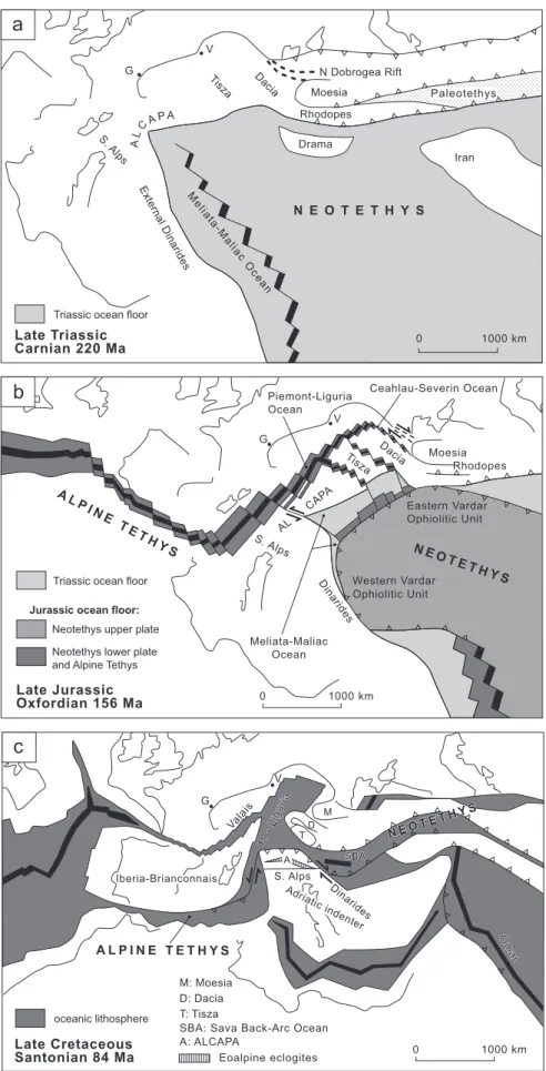
The synthesis advanced here indicates that none of the branches of the Alpine Tethys and Neotethys extended eastward into the Dobrogea Orogen. Instead, the main branch of the Alpine Tethys linked up with the Meliata-Maliac-Vardar branch of the Neotethys into the area of the present-day In-ner Dinarides. More easterly and subsidiary branches of the Alpine Tethys separated Tisza completely, and Dacia partially, from the European continent. Remnants of the Triassic parts of Neotethys (Meliata-Maliac) are preserved only as ophiolitic mélanges present below obducted Jurassic Neotethyan (Vardar) ophiolites. The opening of the Alpine Tethys was largely contem-poraneous with the Latest Jurassic to Early Cretaceous obduction of parts of the Jurassic Vardar ophiolites. Closure of the Meliata-Maliac Ocean in the Alps and West Carpathians led to Cretaceous-age orogeny associated with an eclogitic overprint of the adjacent continental margin. The Triassic Meliata-Maliac and Jurassic Western and Eastern Vardar ophiolites were derived from one single branch of Neotethys: the Meliata-Maliac-Vardar Ocean. Complex
geometries resulting from out-of-sequence thrusting during Cretaceous and Cenozoic orogenic phases underlay a variety of multi-ocean hypotheses, that were advanced in the literature and that we regard as incompatible with the field evidence.
The present-day configuration of tectonic units suggests that a former connection between ophiolitic units in West Carpathians and Dinarides was disrupted by substantial Miocene-age dislocations along the Mid-Hungarian Fault Zone, hiding a former lateral change in subduction polarity between West Carpathians and Dinarides. The SW-facing Dinaridic Orogen, mainly structured in Cretaceous and Palaeogene times, was juxtaposed with the Tisza and Dacia Mega-Units along a NW-dipping suture (Sava Zone) in latest Cre-taceous to Palaeogene times. The Dacia Mega-Unit (East and South Carpath-ian Orogen, including the Carpatho-Balkan Orogen and the Biharia nappe system of the Apuseni Mountains), was essentially consolidated by E-facing nappe stacking during an Early Cretaceous orogeny, while the adjacent Tisza Mega-Unit formed by NW-directed thrusting (in present-day coordinates) in Late Cretaceous times. The polyphase and multi-directional Cretaceous to Neogene deformation history of the Dinarides was preceded by the obduction of Vardar ophiolites onto to the Adriatic margin (Western Vardar Ophiolitic Unit) and parts of the European margin (Eastern Vardar Ophiolitic Unit) during Late Jurassic to Early Cretaceous times.
1. Introduction
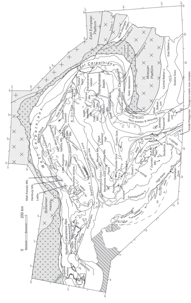
Our analysis of the Alpine-Carpathian-Dinaridic system of orogens including the Pannonian and Transylvanian basins, and of its complex temporal and spatial evolution, is based on a tectonic map that includes the entire system and crosses many national boundaries. This map, presented in Plate 1, was constructed by compiling of available geological maps and sub-surface information for those parts of the system covered by
very thick Mio-Pliocene (in case of the Pannonian basin) or mid-Cretaceous to Late Miocene deposits (in case of the Tran-sylvanian basin).
The map leads to a better understanding of the mobile belts formed during Late Jurassic, Cretaceous and Cenozoic times that are characterized by extreme changes along strike, includ-ing changes in subduction polarity (Alpine-Carpathian polarity vs. Dinaridic polarity; e.g. Laubscher 1971; Schmid et al. 2004b; Kissling et al. 2006). In addition it serves as a base map for
The Alpine-Carpathian-Dinaridic orogenic system: correlation and
evolution of tectonic units
S
TEFANM. S
CHMID1, D
ANIELB
ERNOULLI1, B
ERNHARDF
ÜGENSCHUH2, L
IVIUM
ATENCO3, S
ENECIOS
CHEFER1,
R
ALFS
CHUSTER4, M
ATTHIAST
ISCHLER1& K
AMILU
STASZEWSKI1Key words: tectonics, collisional Orogens, Ophiolites, alps, Carpathians, Dinarides 1661-8726/08/010139–45
DOI 10.1007/s00015-008-1247-3 Birkhäuser Verlag, Basel, 2008
Swiss J. Geosci. 101 (2008) 139–183
1 Geologisch-Paläontologisches Institut, Basel University, Bernoullistr. 35, 4058 Basel, Switzerland. E-mail: [email protected] 2 Geology and Palaeontology, Innsbruck University, Innrain 52 f, A-6020 Innsbruck, Austria.
3 Netherlands Centre for Integrated Solid Earth Sciences, Vrije Universiteit, Faculty of Earth and Life Sciences, De Boelelaan 1085, 1081 HV Amsterdam,
The Netherlands. E-mail: [email protected]
future palinspastic reconstructions that are required to arrive at realistic paleogeographic and paleotectonic reconstructions. The first obvious step towards this goal consists in establishing the Early Miocene geometry of the various tectonic units of the system. A retro-deformation of the very substantial Miocene rotations and translations was first sketched by the pioneering work of Balla (1987). Subsequent attempts included kinematic inversion of pre-Miocene rotations and translations in order to establish the motion and deformation of the different tectono-stratigraphic units involved in the system during the earlier Palaeogene and/or Cretaceous orogenic phases (i.e. Royden & Baldi 1988; Csontos et al. 1992; Csontos 1995; Fodor et al. 1999; Csontos & Vörös 2004). Moreover, numerous contrast-ing reconstructions have been advanced for the opencontrast-ing and closure of the different oceanic domains that form part of Neo-Tethys, including its Alpine branch (e.g. Săndulescu 1980, 1988; Golonka 2004; Haas & Pero 2004; Stampfli & Borel 2004).
All attempts at retro-deformation for Palaeogene and/or Mesozoic times must consider the present-day complex three-dimensional configuration of the entire Alpine-Carpathian-Di-naridic system. Our maps and profiles attempt to provide cor-relations on the basis of which the paleogeographic and paleo-tectonic evolution can be deduced. The data presented here are derived from literature studies and extensive own fieldwork. Naturally the divisions shown on the map (Plate 1) build on ex-isting compilations (e.g. Săndulescu 1975; Channell & Horvath 1976; Royden & Horvath 1988; Csontos & Vörös 2004; Kovács et al. 2004), but use only primary data and own observations for defining the individual units.
Starting with a brief overview of the first order tectonic el-ements, we proceed with detailed descriptions of the individ-ual tectonic units. In support of these descriptions, a series of crustal-scale profiles will be presented. These provide a three-dimensional picture of this complex system of orogens, which formed by a long-lasting evolution, that started in Late Jurassic times and is still going on today (Weber et al. 2005).
2. Method of map compilation
The tectonic map of the Carpathian-Balkan Mountain Sys-tems edited by Mahel (1973) served as base map for the en-tire area covered by our compilation (Plate 1), apart from the Alps, for which we used a simplified version of the tectonic map published by Schmid et al. (2004a). The tectonic map by Ma-hel (1973) was progressively updated by new data. The most important sources of information are referenced. Longitudes and latitudes are marked at the margins of Plate 1. A version of this map giving 1° longitude and latitude grid points can be obtained from the first author. Figure 1 gives geographic and geological names mentioned in the text.
The Pannonian and Transylvanian basin fills, covering large parts of the Alpine-Carpathian-Dinaridic tectonic units, must be removed to understand the correlations and relationships between the different units. The sedimentary fill of these ba-sins is regarded as “post-tectonic” as it rests unconformably on
parts of the Alpine, Carpathian and Dinaridic orogens; how-ever, these sediments were later deformed in many places by deformation associated with basin formation and inversion. In Plate 1, white lines give the outlines of the Pannonian and Transylvanian Basin, and of numerous “inselbergs” in which units of the basin floor are exposed. Buried tectonic boundar-ies were drawn by projecting their suspected or known position to the surface. However, in many places the location of tectonic boundaries below the basin fill remains rather uncertain.
In the Pannonian basin, the post-tectonic fill conceals many crucial contacts between Alpine, Dinaride and Carpathian tec-tonic units. The basin fill mostly consists of Miocene sediments up to 6 km thick (see overview given in Haas 2001). The sedi-ments of the post-tectonic cover of the Pannonian basin typi-cally start with either Late Cretaceous or Palaeogene strata.
Note that we assigned the Cretaceous to Eocene Szolnok Flysch (Haas 2001) to the “bedrock”-units rather than to the post-tectonic fill of the Pannonian basin, because the evolu-tion of this flysch basin clearly differs from that of the rest of the Pannonian Basin (e.g. Baldi & Baldi-Becke 1985). In our compilation the Szolnok Flysch is correlated with similar units occurring in the “Pienides” of Northern Romania (Săndulescu et al. 1981a; Tischler 2005; Tischler et al. 2007) and in the “Pen-nine” units known from the subsurface of the East Slovak Ba-sin (Iňačovce-Krichevo Unit; i.e. Soták et al. 1999). The subsur-face information for this basin largely stems from drill holes (e.g. Fülop & Dank 1987) and from seismic data (e.g. Tari et al. 1999).
The Late Cretaceous to Miocene fill of the Transylvanian Basin (e.g. Huismans et al. 1997; de Broucker et al. 1998) cov-ers many of the more internal units of the East Carpathians and Apuseni Mountains. Only recently, a wealth of information from the floor of this basin became available from hydrocar-bon exploration (e.g. Kreszek & Bally 2006). Much of this as yet largely unpublished information, consisting of seismic re-flection data partly calibrated by bore holes was used during compilation of Plate 1.
The crustal-scale cross-sections given in Plates 2 & 3 were constructed during the compilation the map (Plate 1). Profile construction led to additional insights that significantly im-proved parts of the map. Note however, that the deeper por-tions of the crustal-scale profiles in Plates 2 & 3 are not con-strained by geophysical or borehole data.
3. Overview of the major groups of tectono-stratigraphic units The tectono-stratigraphic units described in detail below define eight groups (Plate 1). Before going into greater details regard-ing map compilation and individual tectonic units, these groups are briefly introduced.
3.1. Undeformed foreland
The northern and eastern flexural foredeep of the Alps and Carpathians (“External Foredeep”) is variably floored by
Va-GEOGRAPHICAL FEA TURES AND LOCAL GEOLOGICAL NAMES BohemianB o h e m ia n massivm a s s iv East EuropeanE a s t E u ro p e a n PlatformP la tf o rm FocsaniF o c s a n i depressiond e p re s s io n Intr amo esian F. Intr am oesi an F . MoesianM o e s ia n PlatformP la tf o rm Pece neag a-C am ena F. T rotus F . T rotu s F . IstriaIs tr ia Ran ova c & V lasi na u nit s R ab a F . S plit-Karlov ac F . Ce rn a-J iu F. B . - D .V . F au lt - B a la to n F . M id -H u n g a ria n fa u lt zo n e G iud ica rie G iu di ca rie G iud ica rie Bohemian massiv Istria Bükk Mts. Darno Uppony Mts. North Apuseni Mts. Bihor Mts. T rascau Mts. Codru Mts. South Apuseni Mts. Cen tral W est Carpathi ans Inner W e st Ca rpathians No rth e rn C al care ou s A lp s Danubian window Dinaric o. W. Vardar o. Getic depression Engadine window T auern window East European Platform Focsani depression Eas t Slova k b asin Intramoes ian F . Little Hungarian Plain Vi enna bas in T ransylvanian basin T ransylvanian nappes M a g u ra f lysc h Moesian Platform Nort h Dobroge a orogen Pece neag a-C am ena F. Pienides Rodna horst E as t C a r p a t h i a n s S ou th C a rp a th ia n s Sav a Zon e W e s t C a r p a th ia n s M id -H un g a ri a n l in e T ransdanubian range L. Bal aton Algyö basement high Fruska Gora Central Balkan u. Sredna Gora W est Balkan unit Jastrebac Korab-Pelagonian
Osogovo-Lisets core complex
East Balkan u. Drau zug Dr i na - Iv a n j i ca Gra u w a c k e n z o n e
Hainburg hills Leitha
Malé Karpaty Mts. Hu rba n ov o -D ió s e n o F . Jad ar Kopaonik Studenica Durmitor Mtn. Zlatibor Mtn. Mecsek Mts. Villany Mts. Morava unit Mir dita o . Moslavacka Gora Medvednica Gora Papuk Motajica Pozeska Gora Bo sn a riv er Prosara Kozara N e k ése ny F. Rechnitz window S o u th T ra n s y lv a nia n F . T rotus F . High Karst Zemplin Szendrö Pe riadriati c Dalmatian Zone Tim ok F. F ig . 1.
riscan, Caledonian or Precambrian basement that is overlain by little or undeformed Mesozoic to Cenozoic sediments. The East European and Scythian platforms were essentially con-solidated during Precambrian times. More recently, the Scyth-ian Platform was re-interpreted as the passive margin of the East European craton that was strongly involved in latest Pre-cambrian to Early Paleozoic (pre-Variscan) tectonic events and that was reactivated during younger and less important events (Stephenson et al. 2004; Saintot et al. 2006). The SW bound-ary of the East European Platform (“Precambrian platform” in Plate 1) coincides with the NW–SE striking Teisseyre-Torn-quist Zone that was repeatedly reactivated during Late Pa-leozoic, Mesozoic and early Cenozoic times (Ziegler 1990). The Pre-Mesozoic basement of areas located to the SW of the Tornquist-Teisseyre Zone consists of an array of essentially Gondwana-derived terranes that were accreted to the margin of the East European craton during the Caledonian and Va-riscan orogenies (Ziegler 1981, 1990; Pharaoh et al. 2006). The Moesian Platform, for example, underwent significant Variscan deformation and was accreted to the Scythian Platform during the Late Carboniferous (Seghedi 2001). In the process of this, the latter also became overprinted by Variscan deformation (e.g. Zonenshain et al. 1990).
The most external units of the allochthonous East Carpath-ian Miocene flysch belt partly override the Teisseyre-Tornquist Zone. Following an Early Triassic rifting event, the Moesian Block was probably separated from the Scythian Platform along the SE-most segment of the Teisseyre-Tornquist Zone, only to be re-accreted to it during the Jurassic Cimmerian North Do-brogean orogeny (e.g. Murgoci 1929; Seghedi 2001) that occu-pies a special position within the Alpine-Carpathian-Dinaridic system (Plate 1). Along the SE-most segment of the Teisseyre-Tornquist Line the Moesian Platform and the North Dobrogea Orogen were welded along the Peceneaga-Camena Fault Zone before the end of the Early Cretaceous (e.g. Murgoci 1915; Hippolyte 2002) when intense tectonic activity along it ceased. Both units are separated by the pre-Neogene Trotus fault from the Scythian Platform (Săndulescu & Visarion 1988).
With respect to the post-Early Cretaceous tectonic activ-ity, the North Dobrogea Orogen, and the Moesian and Scyth-ian platforms are considered as “undeformed foreland”. Only minor reactivation along faults shown by thick black lines in Plate 1 occurred in Miocene-Quaternary times (Tărăpoancă et al. 2003; Leever et al. 2006). The northern fault segment near Bacau (Plate 1), however, is not part of the pre-Neogene Trotus fault, but a Quaternary northern splay of the latter (see Ma-tenco et al. 2007).
The term “Adriatic plate” often refers to the undeformed lithospheric plate or “subplate” (Channell & Horvath 1976) that includes the present day undeformed areas of Istria and the Apulian carbonate platform and is framed by the external thrust belts of Southern Alps, Dinarides and Apennines. This part of the Adriatic plate acted as a rigid indenter during its collisional interaction with the Alpine and Dinaridic orogens to the north and east (Fig. 2c), respectively (e.g. Channell et
al. 1979; Schmid & Kissling 2000; Pinter et al. 2005). However, note that the term “Adria” is also used for denoting the pa-leogeographical affiliation of structural entities that had origi-nally formed part of a larger Adriatic (or “African/Adriatic”; Channell & Horvath 1976) promontory or micro-continent but later became involved in its fringing folded belts (Dercourt et al. 1986). In this contribution the term “Adria” and “Adriatic” will therefore be used for the broader paleogeographical realm that flanked the Alpine Tethys to the south (“Apulia” in the sense of Schmid et al. 2004a), rather than just for the present-day rigid Adriatic plate. Structural entities that later became incorporated into the Alpine-Carpathian-Dinaridic system will be referred to as “Adria-derived”.
3.2. Miocene external thrust belt:
This thrust belt is the only structural element that extends continuously along the margin of the Alpine-Carpathian oro-genic system from the Western Alps through the Western and Eastern Carpathians into the South Carpathians where it ends (Plate 1). In the Carpathians this foreland fold-and-thrust-belt (i.e. Săndulescu et al. 1981a,b; Morley 1996; Matenco & Ber-totti 2000; Krzywiec 2001; Oszczypko 2006) formed during the Neogene when the ALCAPA (Alps-Carpathians-Pannonia) and Tisza-Dacia Mega-Units moved to the northeast and east into an eastward concave embayment in the European fore-land. Their soft collision with the European foreland (e.g. Balla 1987) was triggered by a combination of lateral extrusion (e.g. Ratschbacher et al. 1991a,b) and, more importantly, by the retreat (roll-back) of a subducting eastern European oceanic lithospheric slab (in the sense of Royden 1988, 1993). Calc-al-kaline and alCalc-al-kaline magmatism within the Carpathian arc was closely related to subduction, slab-rollback, slab-detachment and extension in the overriding plate (Nemčok et al. 1998; Wortel & Spakman 2000; Seghedi et al. 2004). In the South Carpathians, where the Miocene fold-and-thrust-belt ends, the inner units of the South Carpathians were juxtaposed with the Moesian Platform during Palaeogene-Miocene time in re-sponse to a combination of strike-slip movements along curved fault systems (Plate 1) and by oblique thrusting (Ratschbacher et al. 1993; Răbăgia & Matenco 1999; Fügenschuh & Schmid 2005; Răbăgia et al. 2007).
3.3. Europe-derived units in the Alps and in the “Dacia” Mega-Unit
This rather heterogeneous group of tectonic units denotes al-lochthonous units, commonly interpreted to have been derived from the European continent. In the Alps these units comprise the Helvetic, Ultrahelvetic and Subpenninic nappes, as well as nappes derived from the continental Briançonnais fragment that broke off Europe (Fig. 2c) in the Early Cretaceous in con-junction with opening of a partly oceanic scar (Valais ocean, e.g. Schmid et al. 2004a). In the Carpathians analogous allochtho-nous units, but not considered as the direct lateral continuation
D D M M: Moesia D: Dacia T: Tisza T S. Alps Ad ria tic ind en ter Iberia-Brianconnais SBA SBA SBA
SBA: Sava Back-Arc Ocean A: ALCAPA A Eoalpine eclogites Valais P. - Ligur ia P. - L igu ria Oman O m an N EO T E TH Y S N EO T E TH Y S P. - Ligur ia Oman A L P I N E T E T H Y S N EO T E TH Y S G V 0 1000 km oceanic lithosphere Late Cretaceous Santonian 84 Ma Dinarides
c
Din arides AL C APA N E OT E T H Y S A L P I N E TE T H YS Moesia S. Alps Dac ia Rhodopes Ti sza 0 1000 km Meliata-Maliac Ocean Piemont-Liguria Ocean G V Eastern Vardar Ophiolitic Unit Ceahlau-Severin Ocean Western Vardar Ophiolitic Unit Triassic ocean floorNeotethys lower plate and Alpine Tethys Neotethys upper plate Jurassic ocean floor:
Late Jurassic Oxfordian 156 Ma
b
Iran Moesia Rhodopes Paleotethys Paleotethys Paleotethys Drama N E O T E T H Y S Dacia Ti sza N Dobrogea Rift Meli ata-M aliac O cean E xternal Dinarid es S. Alps G V 1000 km 0 Late Triassic Carnian 220 Ma AL CA P ATriassic ocean floor
a
Fig. 2. Schematic palinspastic sketches visualizing concepts presented in the text and incorporating ideas mainly taken from Frisch (1979), Frank (1987), Dercourt et al. (1993), Stampfli (1993), Sa˘ndulescu (1994), Stampfli et al. (2001), Marroni et al. (2002) & Schmid et al. (2004a). Positions and projections of the outlines of the European and African continents are those given by Stampfli et al. (2001), except for the coastlines of the Adriatic Sea that we assume to remain firmly attached to the African continent until Cretaceous times. G: Geneva; V: Vienna.
a) Opening of the Neotethyan Meliata-Maliac Ocean in the Triassic (Carnian, 220 Ma).
b) Opening of the Piemont-Liguria Ocean (Alpine Tethys), leading to the separation of the Adria Plate (including the future Southern Alps and ALCAPA), as well as the Tisza and Dacia Mega-Units from the European continent in Oxfordian time (156 Ma). Simultaneously, the Triassic Meliata-Maliac Ocean is being subducted south-eastward below the upper plate Jurassic parts of Neotethys (future Western and Eastern Vardar Ophiolitic Units). The latter are about to become obducted onto the Adria margin, i.e. the future Dinarides, as well as onto the Dacia Mega-Unit.
c) In Santonian times (84 Ma) the two branches of the Alpine Tethys (Valais and Piemont-Liguria Oceans) connect via the Carpathian embayment with younger, i.e. Cretaceous-age branches of Neotethys such as the back-arc ocean that will form the future Sava Zone. Note the onset of northward movement of the Adriatic indenter, contemporaneous with the opening of the East Mediterranean Ocean and the northward drift of Africa.
of their Alpine counterparts, define what is commonly referred to as the Dacia (Fig. 2) Mega-Unit or terrane in the Hungarian literature (e.g. Csontos & Vörös 2004). Parts of this Mega-Unit consist of an assemblage of far-travelled nappes (Infrabuco-vinian-Getic-Kraishte-Sredna Gora and Serbo-Macedonian-Supragetic-Subbucovinian-Bucovinian-Biharia units; also re-ferred to as Median Dacides by Săndulescu 1994) that were derived from blocks, which were detached from the European margin during Jurassic rifting (Fig. 2b). Whilst oceanic litho-sphere of the Ceahlau-Severin Ocean separated parts of these units from Europe, it is unlikely that oceanic lithosphere had separated other units from the European margin. It appears that some nappes, such as the Danubian nappes of the South Carpathians (also referred to as Marginal Dacides; Săndulescu 1994; Kräutner 1996), and units such as the Central Balkan and Prebalkan units of Bulgaria (Georgiev et al. 2001) were directly scraped off the European margin (Moesian Platform; Fig. 1) in response to strong collisional coupling of the orogenic wedge and the foreland (Ziegler et al. 1995).
3.4. Inner Balkanides
While the External Balkanides (Prebalkan, Central Balkan and Sredna Gora units; e.g. Ivanov 1988) can be correlated with other units that form part of Dacia, the Inner Balkanides (“in-ner” with respect to the Moesian foreland of the Balkanides) form a distinct group of tectonic elements whose origin re-mains controversial. Two of these units, that are not the focus of our analysis, reach the southern margin of the map of Plate 1. These are: (i) the Strandja Unit (e.g. Georgiev et al. 2001; Okay et al. 2001) that was strongly deformed, metamorphosed and thrust northward during Late Jurassic to Early Cretaceous time and represents a fragment of an older (“Cimmerian”) orogen, located near the Paleotethys-Eurasia-Gondwana triple point, that was later incorporated into the N-vergent Balkan Orogen; (ii) The Rhodope core complex delimited to the north and west by Cenozoic normal and strike-slip faults (e.g. Sokoutis et al. 1993; Kilias et al. 1999; Brun & Sokoutis 2007). Its bounding Cenozoic faults post-date Early Jurassic to Cretaceous top-S (SW) nappe stacking and high- to ultrahigh-pressure metamor-phism within the gneissic units of the Rhodope Mountains, and they obscure the original relationships of the Rhodope core complex with the neighbouring units (Burg et al. 1996; Turpaud 2006; Perraki et al. 2006; Mposkos & Krohe 2006). The struc-turally lower unit within the Rhodope core complex possibly represents a terrane (Drama terrane in Fig. 2a) that collided with the rest of the Rhodopian units in Jurassic times along the eclogite-bearing Nestos suture (Turpaud 2006; Bauer et al. 2007).
3.5. Units with mixed European and Adriatic affinities: Tisza The crustal fragment, which presently constitutes the nappe sequence of the Tisza Mega-Unit, was separated from Europe during the Middle Jurassic (Fig. 2b), presumably in conjunction
with the opening of the eastern parts of the Alpine Tethys (or Piemont-Liguria Ocean; Haas & Pero 2004). With the opening of an ocean between Europe and Tisza, the latter moved into a paleogeographic position comparable to that of the Austroal-pine or SouthalAustroal-pine realm. The facies of the post-rift sediments within Tisza, such as radiolarites and pelagic Maiolica-type limestones, exhibits Adriatic affinities; the faunal provinces are of the “Mediterranean” type (e.g. Vörös 1977, 1993; Lupu 1984; Haas & Pero 2004). Much of the tectonic units of Tisza (Mecsek, Bihor and Codru nappe systems) are only exposed in isolated and rather small inselbergs within the Pannonian plain (i.e. Mecsek nappe system in the Mecsek Mountains in Hun-gary; Haas 2001). A coherent nappe sequence is only present in the North Apuseni Mountains of Romania (Bihor and Codru nappe systems; Balintoni 1994). The tectonically highest and most internal nappe system of the North Apuseni Mountains is the Biharia nappe system (Balintoni 1994), traditionally con-sidered as a constituent of Tisza (Csontos & Vörös 2004), i.e. the Internal Dacides (Săndulescu 1984; Balintoni 1994). How-ever, we correlate this Biharia nappe system with the Bucovin-ian nappes (Plate 1) and hence attribute it to Dacia (i.e. the Median Dacides in the sense of Săndulescu 1984) for reasons discussed later.
3.6. Adria-derived far-travelled nappes of the internal Alps and the West Carpathians (ALCAPA Mega-Unit):
This group of tectonic elements is referred to as the Austroal-pine nappes in the Alps (e.g. Schmid et al. 2004a) and as the Central and Inner West Carpathians in the Carpathians (e.g. Plašienka et al. 1997a,b). In the Alpine literature these elements are often referred to as being derived from Adria (or “Apulia” in the sense of Schmid et al. 2004a). In the Alps this implies that their initial paleogeographical position was to the south of the Piemont-Liguria Ocean, the main branch of the Alpine Tethys (Fig. 2b). Presently, these elements represent far-travelled thin crustal slices found in an upper plate position above the Upper Penninic (or Vahic in case of the West Carpathians) suture zone and the underlying Europe-derived elements of the Alps and West Carpathians.
Note, however, that the notion of Adria as a single paleo-geographic entity becomes problematic in the easternmost Alps and the adjacent Carpathians and Dinarides owing to the oc-currence of branches of a second group of oceanic realms that formed part of the so-called “Neotethys” (e.g. Haas 2001). Neo-tethys formed an eastward opening oceanic embayment in the Adria paleogeographical realm that had opened during Triassic times (Fig. 2a) and is referred to as Meliata Ocean in the Alps and Carpathians (i.e. Channell & Kozur 1997), but as Maliac Ocean in the Hellenides (e.g. Stampfli & Borel 2004). Hence the Austroalpine nappes and their extension into the West Car-pathians include tectonic elements that were positioned north, west and south of the Meliata-Maliac Ocean (Fig. 2; Schmid et al. 2004a). Sea-floor spreading continued in Neotethys during the Jurassic, but the connections between the various oceanic
realms formed in Jurassic times with those of the Alpine Tethys are not yet properly understood; Figure 2 merely represents an attempt to satisfy the data compiled in this work.
3.7. Adria-derived thrust sheets: Southern Alps and Dinarides The units that comprise parts of the Adria paleogeographic realm presently located south of the Periadriatic Line and its eastern continuation (Balaton Line), i.e. south of the ALCAPA Mega-Unit, constitute the Southern Alps and all the non-ophi-olitic tectonic units of the Dinarides, including a fragment dislo-cated along the Mid-Hungarian Fault Zone (Bükk Mountains of Northern Hungary). During the Triassic these units were also lo-cated south (or rather southwest, Fig. 2a) of the Meliata Ocean, and thus they were derived from the northern passive margin of Adria that faced the Meliata-Maliac-Vardar branch of Neote-thys. In our view the Drina-Ivanjica, Korab-Pelagonian, Bükk, Jadar and Kopaonik “terranes” or “blocks” (e.g. Dimitrijević 2001; Karamata 2006) all represent units that structurally under-lie remnants of what we refer to as Vardar Ocean in this contri-bution, i.e. Neotethyan ophiolites of Jurassic age that were ob-ducted onto the Adria margin during the Late Jurassic (Fig. 2b). Presently, the most external northern Dinaridic units are sepa-rated from the Southern Alps by the eastward continuation of a south verging dextrally transpressive thrust front, which formed at a late stage (Mio-Pliocene) in the tectonic history of the Al-pine-Carpathian-Dinaridic system. From northeastern Italy and Slovenia we trace this transpressive thrust front into Hungary as far to the east as south of lake Balaton (Plate 1).
In summary, this group of units was derived from continen-tal cruscontinen-tal domains located far to the south of the Alpine Tethys, and even south (or southwest in case of the Southern Alps) of the Neotethys (Fig. 2). Note that many of the detached units of this group overlie an autochthonous basement that is presently still associated with its lithospheric underpinnings (Schmid et al. 2004b); they thus represent deformed parts of the present-day Adriatic plate.
3.8. Ophiolites and accretionary prisms
This group of tectonic units is characterized by ophiolitic and/or flysch-type rock associations and is extremely heterogeneous. It comprises tectonic elements, some of which can be traced along strike over long distances; they often define important sutures and/or important mobile zones between and occasionally also within the above described groups of tectonic elements.
Here we will use the term “ophiolite” in a wider sense, that is we do not restrict the term to rock associations formed at mid-ocean ridges. We also include other types of magmatic and sedimentary rock associations that are indicative of the pres-ence of former oceanic lithosphere. Hpres-ence we include, for ex-ample, supra-subduction ophiolites and/or subduction-related volcanic arc rocks that developed within pre-existing oceanic crust (see discussion on ophiolite models in Robertson 2002). Moreover, we use the term “ocean” as denoting
paleogeo-graphic domains we suspect to have been floored by oceanic rather than continental lithosphere.
It is important to realize, however, that in some cases the ophiolites were obducted as thrust sheets and hence do not mark the location of a deeper suture zone (e.g. Western Var-dar Ophiolitic Unit of Plate 1). Others (e.g. the remnants of the Meliata-Maliac Ocean) are only found as blocks within mélange formations beneath coherent ophiolitic thrust sheets such as the Western Vardar Ophiolitic Unit that were obducted during the Late Jurassic (Fig. 2b). Some ophiolitic mélange and obducted ophiolites became subsequently involved in the development of composite thrust sheets or nappes, consisting of continental units and previously obducted ophiolites that formed by out-of-sequence thrusting during Cretaceous and Cenozoic orogenic cycles.
The interrelationships between individual elements of this group of tectonic units still remain uncertain in many cases. This is due to a poor understanding on how Miocene mations and even more so Palaeogene and Cretaceous defor-mations and translations ought to be retro-deformed. In this sense, all existing paleogeographic reconstructions for the Al-pine-Carpathian-Dinaridic area for Triassic, Jurassic or Creta-ceous times, of course including those presented in Fig. 2, must be regarded as purely speculative.
These uncertainties necessitate the continued use of many regional or local names for these ophiolitic and/or accretion-ary wedge units (see discussion by Zacher & Lupu 1999). Nevertheless, we find it convenient to use the terms Alpine Tethys and Neotethys in order to denote two groups of oceans that began to open in Permian (?) to Mesozoic times in con-junction with the break-up of Pangaea (e.g. Stampfli & Borel 2004).
We use the term “Alpine Tethys” collectively for all oceanic realms in the Alpine-Carpathian domain, the opening of which was kinematically directly linked to sea-floor spreading in the Central Atlantic (Figs. 2b and 2c) that was initiated in late Early Jurassic times (Favre & Stampfli 1992). The term “Neotethys” is used for all oceanic realms located in an area southeast of the Alpine Tethys and the future Western Alps that opened during and after the Permian to Triassic closure of Paleotethys, which at the end of the Variscan orogeny had still separated Gond-wana and Laurussia (e.g. Stampfli & Borel 2004). Opening of the oceanic Neotethys basins was neither temporally nor kine-matically linked to the opening of the Alpine Tethys. In contrast to the Alpine Tethys, parts of Neotethys were consumed in the context of obduction during Late Jurassic times (Fig. 2b), with a kinematic link to the opening of the Central Atlantic (e.g. Dinaridic ophiolites; Laubscher 1971; Pamić et al. 2002a), while others opened later during the Cretaceous (Sava Back-Arc Ophiolites of Fig. 2c). Yet it is debatable whether during the Jurassic the oceanic realms of the Alpine Tethys and Neotethys were completely separated or linked somewhere in the Alpine-Carpathian-Dinaridic realm (as proposed in Fig. 2b). However, we will present arguments to propose that Cretaceous-age oce-anic branches of Neotethys (such as the Sava Back-Arc Ocean,
Fig. 2c) were directly linked with the Alpine Tethys along the present-day Sava-Zone mapped in Plate 1.
We attribute the following oceanic basins to the Alpine Te-thys: (i) The Valais, Rhenodanubian and Magura flysch units forming a northern branch (Schnabel 1992; Plašienka 2003; Schmid et al. 2004a), and (ii) the Piemont-Liguria-Vahicum-Pieniny Klippen Belt (Birkenmajer 1986; Plašienka 1995a) units defining a southern branch. Both branches were at least partly separated by the continental Briançonnais fragment of the Western Alps (Frisch 1979; Stampfli 1993) and possibly by smaller analogous units found as relics in the Pieniny Klippen Belt of the West Carpathians (Birkenmajer 1986; Trümpy 1988) that probably were not directly linked with the Briançonnais.
According to our interpretation the Magura Flysch and the Piemont-Liguria-elements of the Alpine Tethys can be traced SE-ward via the Iňačovce-Kriscevo Unit of Eastern Slovakia and the Ukraine (Soták et al. 1993, 1999) into the flysch units referred to as the Pienides of northern Romania (Săndulescu et al. 1981a). In map view, the latter form a tight E-verging arc (Plate 1) and were thrust onto the Tisza-Dacia Mega-units dur-ing Miocene times (Fig. 3; Tischler et al. 2007). We propose to connect the Pienides with the Szolnok Flysch in the subsur-face of the Pannonian Basin. The ophiolitic Szolnok Flysch belt (“ophiolite-bearing Intrapannonian belt” of Channell et al. 1979) can be traced westward along the Mid-Hungarian Fault Zone towards Zagreb where it links up with the ophiolite-bear-ing Sava Zone (Plate 1). This zone consists of a belt of ophi-olitic (relics of the Sava Back-Arc Ocean, Fig. 2c), magmatic and metamorphic rocks that extends SE-ward from Zagreb to Belgrade (“North-western Vardar Zone” of Pamić 1993; “Sava-Vardar Zone” of Pamić 2002). The Sava Zone defines the Late Cretaceous to Palaeogene suture between Tisza and the Dina-rides. Between Zagreb and Belgrade this Sava Zone connects the SE branch of the Alpine Tethys with the Cretaceous-age branches of Neotethys further to the southeast (Fig. 2c). At present the Sava Zone, located between the Western and East-ern Vardar Ophiolitic Units (see Plate 1), represents the suture between the Dinarides and the Tisza-Dacia Mega-Units. The latter are derived from older branches of Neotethys.
The narrow, possibly only partly oceanic Ceahlau-Severin rift opened during Middle to Late Jurassic times (e.g. Ştefănescu 1995; Fig. 2b). Hence it is considered as the easternmost branch of the Alpine Tethys rather than a branch of Neotethys. Note, however, that in present-day map view (Plate 1) it does not directly connect with the easternmost branch of the Alpine Tethys of the Western Carpathians in Northern Romania and adjacent Ukraine, nor does it link up with the Transylvanian branch of the Eastern Vardar Ophiolitic Unit. Westward, units attributed to the narrow Ceahlau-Severin Ocean join the Ma-gura Flysch Unit (Plate 1) that in Miocene times was thrust to-wards the SE (Fig. 3; Tischler et al. 2007) and that connects with the Mid-Hungarian Fault Zone (see above). Southward, the Ceahlau-Severin Ophiolitic Unit, which is well exposed in the South Carpathians, eventually appears to wedge out in west-ern Bulgaria and eastwest-ern Serbia; no equivalents of this narrow
ocean have been ascertained in the Balkan Orogen. Figure 2b depicts two additional eastern branches of the Alpine Tethys, which are proposed to kinematically connect with the Trias-sic Neotethys Ocean and whose opening led to the separation of the Dacia and Tisza blocks from Europe. The relics of the branch between the Dacia and Tisza Mega-Units (Fig. 2b) will form the suture between the Dacia and Tisza Mega-Units in Early Cretaceous times, only preserved in the subsurface (see Plate 3, Profile 3). The branch between the Tisza and ALCAPA Mega-Units (Fig. 2b) forms part of the Mid-Hungarian Fault Zone (Fig. 1, Plate 1), i.e. the “ophiolite-bearing Intrapanno-nian belt” of Channell et al. (1979).
In the Alpine-Carpathian-Dinaridic system of orogens the westernmost branch of Neotethys (Fig. 2a) is known as the Meliata Ocean (Kozur 1991) that had opened earlier, i.e. in Triassic times (e.g. Velledits 2006). However, in our area, the ophiolitic remnants of the Meliata-Maliac Ocean do not form coherent thrust sheets, but are only preserved as blocks contained in Mid to Late Jurassic-age ophiolitic mélange for-mations. Such mélange formations occur in the Eastern Alps and West Carpathians (Kozur & Mostler 1991). Remnants of this same Meliata-Maliac Ocean are also found as blocks in Jurassic mélange formations that immediately underlie the obducted Western Vardar ophiolites in the Bükk Mountains (Monosbel nappe of Csontos 1999, 2000) and in the Dinarides (ophiolitic mélange formations; e.g. Babić et al. 2002). In the Dinarides these mélange formations are also referred to as “Diabas-Hornstein” (Kossmat 1924), “Diabase-Radiolarite” Formation (Ćirić & Karamata 1960) or “wildflysch with ophi-olitic detritus” (Laubscher & Bernoulli 1977). Note that all ob-ducted ophiolitic thrust sheets, which overlie these ophiolitic mélange formations, as seen in the Bükk Mountains (Darno-Szavarskö ophiolites; Csontos 2000) and Dinarides (Western Vardar Ophiolitic Unit; e.g. Pamić et al. 1998; Dimitrijević 2001; Karamata 2006), consist of Jurassic age ophiolites. We suggest that these Jurassic Western Vardar ophiolites, together with the Triassic Meliata-Maliac ophiolites, once formed part of one and the same Neotethyan oceanic branch before obduction began (Fig. 2b), i.e. before Mid-Jurassic times. During the latest Ju-rassic to Early Cretaceous the young (Early to Mid-JuJu-rassic) Western Vardar Ophiolitic Unit was obducted onto the passive continental margin of Adria, the ophiolite mélange formation defining the tectonic contact zone.
The Eastern Vardar Ophiolitic Unit extends into the South Apuseni and Transylvanian ophiolite belt and represents an-other part of the Meliata-Maliac-Vardar Neotethys (Săndulescu 1984) that was probably obducted onto the European Margin (Dacia Mega-Unit, Fig. 2b). Its original location with respect to that of the Western Vardar ophiolites is still enigmatic. We emphasize that the Eastern Vardar ophiolitic belt does not ex-tend along the Sava Zone towards Zagreb. Hence, the Eastern Vardar Ophiolitic Unit does not form part of the Dinarides. Instead, it is now the most internal, structurally highest tectonic element on top of the Dacia Mega-Unit. In turn this implies that the Eastern Vardar ophiolites cannot be linked with the
1000 0 -2000 -3000 -4000 -5000 -6000 -1000 2000 1000 0 -2000 -3000 -4000 -5000 -6000 -1000 2000 WNW 132°107° ESE [m] [m] Base mid-Miocene Bucovinian nappes Mid-Miocene and younger, undifferentiated
Badenian (base Mid-Miocene) Dej-tuff fm.
Eocene, fine grained siliciclastics
Eocene, sand dominated siliciclastics
Oligocene, sand dominated siliciclastics
Oligocene, sand dominated siliciclastics
Oligocene, fine grained siliciclastics
Upper Cretaceous -Paleocene
External Pienides = Magura Flysch Neogene of the Pannonian Basin
“Post-tectonic” sedimentary cover of the Dacia Mega-Unit
Dacia Mega-Unit Eocene
Petrova nappe
Leordina nappe
fault thrust /reverse fault normalfault “Post-tectonic” sedimentary
cover of the Dacia Mega-Unit
Dacia Mega-Unit
Pienides External Thrust Belt
Neogene of the Pannonian Basin Burdigalian molasse
External Pienides = Magura Flysch: Moldavites
Ceahlau - Severin ophiolitic unit Neogene volcanics post-Burdigalian sediments WF: Wildflysch nappe L: Leordina nappe P: Petrova nappe Pieniny Klippen Belt Internal Pienides: Botiza nappe
(Piemont-Liguria Ocean)
Eocene - Early Miocene Late Cretaceous Biharia Unit Bucovinian nappes Preluca fault Preluca fault Bogdan Voda f ault Bogdan Voda f ault
Dragos Voda fault Dragos Voda fault
Greben f ault Greben f ault Rodna Horst Rodna Horst Maramures Mts. Maramures Mts. P WF L Rodna Rodna Borsa Sighet Baia Mare 20 km
A
A'
a.
b.
A
A'
Fig. 3. Map (a) and cross-section (b) through the contact area between the ALCAPA and the Tisza-Dacia Mega-Units in Northern Romania (Maramures) after Tischler (2005) and Tischler et al. (2007). The Pienides of the Maramures area in Northern Romania form a tight arc in map view and were thrust onto the Tisza-Dacia Mega-units during Miocene times.
Alpine Tethys around the western margin of Tisza, nor do they extend E-ward into the North Dobrogea Orogen. In the south, i.e. between Beograd and Skopje, the Neotethyan Western and Eastern Vardar Ophiolitic Units parallel each other but are separated by a narrow band of the Sava Zone that, in our view, represents a suture zone between the Dinarides and the Tisza-Dacia Mega-Units which, in the Late Cretaceous, included their earlier obducted ophiolite sheets (Plate 1).
We conclude (1) that none of the branches of the Alpine Te-thys and of NeoteTe-thys extends eastward into the North Dobro-gea Orogen, although such connections have been proposed by many paleogeographic reconstructions (e.g. Stampfli & Borel 2004). The Triassic North Dobrogea rift (i.e. the Niculitel Zone; Savu et al. 1977; Seghedi 2001), which formed during a Permo-Triassic rifting event that affected also central Moesia, dies out rather rapidly northwestward (see review by Tari et al. 1997). We propose (2) that the ophiolitic remnants of Neotethys (the Triassic-age Meliata-Maliac ophiolites and the Jurassic-age Var-dar ophiolites) occurring in the area of consideration formed part of one and the same Meliata-Maliac-Vardar oceanic basin. We will show later that there is no evidence for the existence of a “Pindos Ocean” and thereby accept the “one-ocean hypoth-esis” first formulated by Bernoulli & Laubscher (1972). We are convinced (3), that the different branches of Tethys found in the Alpine-Carpathian-Dinaridic system can only be followed eastward via the Dinarides and Hellenides into Turkey, but not into the Cimmerian system of the Black Sea to the north.
4. Detailed description of individual tectonic units of the Alps, Carpathians and Dinarides
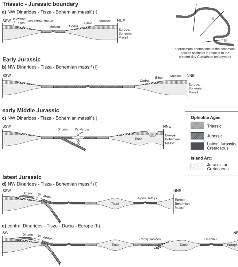
This section provides the most important sources used for de-fining tectonic units and constructing the map (Plate 1). More-over, a more detailed overview of all the tectonic units is pre-sented and supported by a series of crustal-scale cross-sections (Plates 2 & 3). Names of tectonic units listed in the legend of Plate 1 are given in bold letters. The Alps will not be treated in detail (see Schmid et al. 2004a for a comprehensive review). We provide a relatively more comprehensive overview of the Dinarides since they are the least known part of the system.
4.1. The Miocene fold-and-thrust belt of the Alps and Carpathians
The Cretaceous and Cenozoic flysch units of the external Car-pathian fold-and-thrust belt underwent most, though probably not all their total shortening during Miocene times. Deforma-tion progressively migrated towards the foreland (Săndulescu et al. 1981a,b; Roca et al. 1995; Morley 1996; Zweigel et al. 1998; Matenco & Bertotti 2000).
The Neogene evolution of this flysch belt was mainly driven by the retreat of the Alpine Tethys subduction slab into the Carpathian embayment (Royden 1988). Prior to the Late Cre-taceous onset of subduction, this embayment was occupied by Late Jurassic to Early Cretaceous oceanic lithosphere of the
Alpine Tethys that was attached to the European continent (Balla 1987; Fig. 2c). Subduction of this oceanic lithosphere started from the Late Aptian to Albian onwards. It’s covering Late Jurassic – Early Cretaceous sediments were scraped off, forming the Ceahlau/Severin nappe that was emplaced about 75 Ma ago (“Laramide” emplacement of the Ceahlau-Severin Ophiolitic Unit; e.g. Săndulescu et al. 1981a,b). There are several popular models such as slab detachment (e.g. Wortel & Spak-man 2000; Sperner et al. 2005; Weidle et al. 2005), slab delami-nation (e.g. Girbacea & Frisch 1998; Gvirtzman 2002; Knapp et al. 2005), or thermal re-equilibration of the lithosphere (e.g. Cloetingh et al. 2004) that have been proposed to explain the evolution of this subduction and its present-day expression as a near vertical high velocity mantle anisotropy beneath Vrancia (e.g. Martin et al. 2006). Whatever model is adopted, all of them invoke a Miocene retreat of the subducted oceanic slab as the principal driving force for the final emplacement of the conti-nental ALCAPA and Tisza-Dacia Mega-Units that occupy the internal parts of the Carpathian loop.
The Carpathian thrust belt consists mainly of flysch units in its inner part and grades outward into progressively more shallow-water strata, the most frontal thrusts involving the in-ner parts of the Carpathian foredeep. The most internal thrusts were emplaced in Late Cretaceous time whereas the external thrusts are of Neogene age. The age of the youngest thrust de-formation at the front of this fold-and-thrust belt decreases from the West Carpathians (ca. 18 Ma) towards the Polish and Ukrainian Carpathians where the latest movements are dated as Late Miocene (ca. 12 Ma; Krzywiec 2001). Further to the SE and S along the entire East Carpathians to the bending zone north of Bucharest the age of the youngest thrusts remains constant at around 11 Ma, though the amount of shortening accomplished across them increases significantly in the Roma-nian segment (Roure et al. 1993; Dicea 1995; Matenco & Ber-totti 2000; Krzwiec 2001). This was partly accommodated in the internal parts of the Carpathians by coeval late-stage sinistral strike-slip motion along the contact between ALCAPA and Tisza-Dacia (e.g. Tischler et al. 2007). The external flysch belt in the East Carpathians is completely allochthonous and con-tains sediments formerly deposited on continental or oceanic crust of the Carpathian embayment. However, these sediments, which are incorporated in the Miocene-age nappe sequence, do not contain any detritus from an oceanic basement (e.g. Săndulescu 1988). Hence the hypothesis that parts of the Car-pathian embayment were underlain by oceanic crust (e.g. Balla 1987) remains speculative.
The external Carpathian fold-and-thrust belt consists of three nappes or thrust systems, some of which can be traced all the way along strike. These nappe systems are best developed in the East Carpathians where they are referred to as the Mol-davides (Săndulescu 1994).
The external-most tectonic unit consisting of Middle Eo-cene to Late MioEo-cene sediments, the thrusted internal
fore-deep, is called Subcarpathian nappe in the East Carpathians
the undeformed sediments of the Carpathians foreland, i.e. the external foredeep (Plate 3, Profile 3), can be traced north along strike into Ukraine where it wedges out between external fore-deep and more internal thrust sheets (e.g. Kováč et al. 1999; Oszczypko 2006). In the foreland of the Romanian Carpath-ian bend zone and the South CarpathCarpath-ians this unit is partly buried beneath the latest Miocene-Pliocene (post-11 Ma), es-sentially undeformed sediments of the Dacic Basin (e.g. Jipa 2006) (Plate 2, Profile 4). The depocenter of these sediments is located near the town of Focsani (“Focsani Depression”; Tărăpoancă et al. 2003).
The Cenozoic Dacic basin forms the western branch of the larger and endemic Eastern Paratethys basin that was isolated from the Mediterranean and World Ocean since the beginning of the Oligocene in response to orogenic uplift of the Alpine-Carpathian-Tauride Caucasus domains (e.g. Rögl 1999). Parts of the Dacic basin, located between the Intramoesian and Tro-tus/Peceneaga-Camena Faults, were inverted during the Qua-ternary by folds and reverse faults involving the lower plate of the Eastern Carpathian thrust system; this led to the develop-ment of the synclinal configuration of the Focsani Depression (Plate 3, Profile 3; see also Leever et al. 2006).
In the South Carpathians foreland, the most internal and deformed part of the foredeep is referred to as Getic Depres-sion. Although its latest Cretaceous to Late Miocene sediments are buried beneath the post-tectonic cover of the Dacic basin, subsurface data show that these were thrust over the Moesian foreland (Motaş & Tomescu 1983; Săndulescu 1988) (Plate 2, Profile 4). During the progressive N-, NE-, E- and ESE-ward transport of the Tisza-Dacia Mega-Units around Moesia, the Getic Depression was dominated by dextral strike-slip displace-ments. However, the total amount of Cenozoic shortening in the East Carpathians (<160 km; Ellouz et al. 1994) was largely accommodated within the South Carpathians (Fügenschuh & Schmid 2005; Răbăgia et al. 2007) rather than by shortening within the sediments of the Getic Depression. Palaeogene oro-gen-parallel extension within the South Carpathians (Schmid et al. 1998) was followed by Palaeogene to Early Miocene dextral movements and transtension along curved faults systems such as the Cerna-Jiu and Timok faults (Berza & Drăgănescu 1988; Ratschbacher et al. 1993; Kräutner & Krstić 2002, 2006). For this reason it is suspected that the predominantly Miocene-age shortening in the East Carpathians may have already started in Palaeogene times and that Middle to Late Miocene transpres-sion and thrusting of the internal foredeep over Moesia is only of secondary importance (Răbăgia & Matenco 1999).
The Marginal Folds and Tarcau thrust system makes up the middle of three major Neogene thrust systems of the East Carpathians and involves Early Cretaceous to Early Miocene flysch series. Towards the SW the amount of shortening across this thrust system decreases and is gradually transformed into limited transpressional deformations where it merges into the South Carpathians (Plate 1). To the west of the bending area this thrust system wedges out completely and is missing in the South Carpathians where transpression was absorbed in the
Subcarpathian nappe (Ştefănescu et al. 2000; Matenco et al. 2003). Northwards, these two units are traced into the Skole Unit of Poland (e.g. Oszczypko 2006) where this intermediate thrust system wedges out to the west.
Only the oldest and most internal thrust system of the Car-pathian Miocene fold-and-thrust belt can be followed all along the East and West Carpathians into the Alps. In the East Car-pathians it consists of, from external to internal, of the Audia,
Macla and Convolute Flysch units that contain Late
Creta-ceous to Palaeogene strata (Săndulescu 1981a,b). These units gradually wedge out westward in the South Carpathians where they record SE-directed thrusting. Their internal geometry in-dicates associated strike-slip movements (Matenco & Bertotti 2000). Northwards, these units can be correlated with the exter-nal Subsilesian, intermediate Silesian and interexter-nal Dukla units of the Polish West Carpathians (Morley 1996; Kováč et al. 1999) that comprise Late Jurassic to Miocene sediments (Oszczypko 2006). Further west, in Slovakia, where the Dukla Unit is tec-tonically covered by the Magura Flysch Unit (Plate 2, Profile 2), the Silesian and Subsilesian Units can be traced westward into the Czech Republic (Zdanice Unit; Picha & Stranik 1999) and finally into the Waschbergzone of the easternmost Alps (“Mo-lasse Zone” of Wessely 1987 in Profile 1 of Plate 2). Further westwards this unit wedges out. The Subalpine Molasse thrust slices of the Alps in western Austria and Switzerland were also mapped as part of this thrust system. Note, however, that in terms of basin evolution and tectonic position these Molasse sediments have little in common with their counterparts in the Eastern Alps and Carpathians.
4.2. Alps and West Carpathians (ALCAPA Mega-Unit) 4.2.1. What is ALCAPA?
The term ALCAPA (Alps-Carpathians-Pannonia) as defined by Csontos & Vörös (2004) stands for a tectonic mega-unit that includes the Eastern Alps, the West Carpathians and the Transdanubian ranges north of Lake Balaton. The Miocene fill of the Pannonian Basin separates these three major areas of older rock exposures from one another. We mapped the exact boundaries of ALCAPA as follows on Plate 1:
The contact between the Rhenodanubian and Magura flysch units along with the Miocene flysch fold-and-thrust belt delim-its the northern boundary of this Mega-Unit, which underwent a combination of lateral escape, thinning and subsidence dur-ing the Miocene evolution of the Pannonian Basin in Miocene times (Ratschbacher et al. 1991a,b; Horvath et al. 2006). The Periadriatic Line and its eastern extension, the Balaton Line (Fodor et al. 1998), that were active during this escape, define the southern boundary of ALCAPA all the way to Lake Bala-ton. The Balaton Line was delineated according to the compila-tion of subsurface data provided by Haas et al. (2000). Further east, we define the southern boundary of ALCAPA according to subsurface data provided by Csontos & Nagymarosy (1998) and Fülöp & Dank (1987). However, and in contrast to the
us-age of the term ALCAPA by previous authors, we exclude the Bükk Mountains from this Mega-Unit. The principal reason is that the Bükk Mountains can nowadays be considered as a piece of the Dinarides (Kovács et al. 2000, 2004; Dimitrijević et al. 2003; Velledits 2006) rather than part of the Alpine-West Carpathian chain. The Bükk Mountains were displaced within the Mid-Hungarian Fault Zone (Tischler et al. 2007), a broader fault zone that is delimited to the south by the Mid-Hungar-ian Line (Csontos & Nagymarosy 1998), or “Zagreb-Zemplin Line” (Haas et al. 2000), and to the north by the eastern con-tinuation of the Balaton Line. Consequently, we let the south-ern boundary of ALCAPA coincide with the southsouth-ern part of the Darno Line and further eastwards with the Nekéseny Fault (Haas 2001; see Fig. 1). These fault zones separate the Bükk Mountains from two inselbergs that we consider as part of the Inner West Carpathians (Uppony and Szendrö Mountains of NW Hungary; see Haas 2001, his Figs. 78 & 106). The eastern tip of ALCAPA extends into Northern Romania where it was identified from subsurface and field data (Săndulescu et al. 1978, 1993; Kováč et al. 1995; Tischler et al. 2007).
4.2.2. Europe-derived units within ALCAPA
In Plate 1, and regarding the Alps, we grouped the Helvetic and Ultrahelvetic cover nappes including the External Mas-sifs (Helvetic) together with the Subpenninic nappes. The term “Subpenninic” denotes pre-Mesozoic basement units, on which the sediments now exposed in the Helvetic and Ultra-helvetic nappes were originally deposited, as well as more distal parts of the European upper crust, and its metamorphic cover, as exposed in the Tauern window (Schmid et al. 2004a; see Fig. 1). The most internal Europe-derived nappes are paleogeographically assigned to the Briançonnais, a crustal block that was detached from the European passive margin during the Early Cretaceous opening of the Valais branch of the Alpine Tethys (Fig. 2c; Frisch 1979; Stampfli 1993). The easternmost Briançonnais nappes are exposed in the Enga-dine window (Fig. 1).
However, according to our interpretation Subpenninic units extend in the subsurface much further to the east. For instance Subpenninic units, referred to as “Penninic” in the crustal-scale profile across the easternmost Alps by Tari (1996), are needed to fill the space between the base of ophiolitic nappes attributed to the Alpine Tethys (as exposed nearby in the Rechnitz win-dow) and the Moho (Plate 2, Profile 1). However, we suspect the presence of such Subpenninic units in the subsurface also further to the east, namely in the West Carpathians (Plate 2, Profiles 1 & 2). Information on the deep structure of the West Carpathians is provided by a seismic transect presented by Tomek (1993) who assigned a large rock volume below the Alpine Tethys suture (Vahicum; Plašienka 1995a,b) to the Bri-ançonnais. Yet, as the Briançonnais paleogeographic domain proper terminates west of the Tauern window (Schmid et al. 2004a), except for some small analogous crustal slivers found in the Pieniny Klippen Belt of the West Carpathians (Birkenmajer
1986; Trümpy 1988), we prefer to attribute this rock volume to the distal European margin, that is, to the Subpenninic units.
A direct comparison of the profiles across the Eastern Alps and West Carpathians (Plate 2, Profiles 1 & 2) highlights an important difference pertaining to the northern boundary of ALCAPA, which is only evident in cross sections. In the profile across the easternmost Alps (Plate 2, Profile 1) the basement of the undeformed European foreland is traced along a gently inclined thrust at the base of the Alpine accretionary wedge far to the south into the area of the Hungarian Plain (Tari 1996). By contrast, the profile through the West Carpathians (Plate 2, Profile 2) depicts a steeply dipping dextral strike-slip zone in the depth projection of the Pieniny Klippen Belt according to our interpretation. This crustal-scale sinistral strike-slip fault zone was active during the Miocene and formed the northern boundary of the ALCAPA Mega-Unit (Central and Inner West Carpathians) during its eastward escape (i.e. Nemčok 1993; Sperner et al. 2002). It thus post-dates nappe emplacement in the Inner West Carpathians. The northern parts of Profile 2 (Plate 2) suggest that the European foreland crust was imbri-cated (modified after Roca et al. 1995) during the transpres-sional emplacement of ALCAPA and the development of the Miocene West Carpathian fold-and-thrust belt. In this process the Outer West Carpathian Magura Flysch Unit was imbricated and accreted to ALCAPA whilst severe late-stage Miocene NNE-SSW-directed back-thrusts affected the more internal units in the High Tatra Mountains (Plate 2, Profile 2) (Sperner et al. 2002).
4.2.3. Remnants of the Alpine Tethys in ALCAPA
Most authors accept the existence of two branches of the Al-pine Tethys, the Piemont-Liguria and Valais Oceans, respec-tively. However, this division can only be made where remnants of the intervening Briançonnais micro-continent are present. This is no longer possible east of the Engadine window. Hence, at first sight a paleogeographic separation of the Alpine Tethys into two separate branches (Froitzheim et al. 1996; Schmid et al. 2004a) becomes redundant in the Eastern Alps (see discus-sion in Kurz 2005 and Schmid et al. 2005) where these branches apparently merged into one single oceanic basin. Nevertheless, we make a distinction between the eastern equivalents of these two branches since an evaluation of the timing of accretion of these oceanic units (Late Cretaceous vs. Cenozoic) to the Aus-troalpine, respectively to the West Carpathian Tatric-Veporic-Gemeric upper plate, is an important criterion for distinguish-ing between the equivalents of the two branches of the Alpine Tethys east of the Engadine window (for additional criteria see discussion in Schmid et al. 2005). Consequently, we correlate the Valais Ocean with the Rhenodanubian Flysch since accre-tion of both units the to the Alpine nappe sequence occurred in Eocene times. The lateral equivalent even further east and in the West Carpathians is the Magura Flysch accreted to the Tat-ric-Veporic-Gemeric orogenic wedge during Late Oligocene to Miocene times.
The Pieniny Klippen Belt (Birkenmajer 1986) was mapped separately (Plate 1) because it represents a rather peculiar, sub-vertical and narrow structural unit at the surface (Plate 2, Pro-file 2). It forms the boundary between Outer and Central West Carpathians for some 700 km from the St. Veit Klippen near Vienna to northern Romania. This belt typically consists of rel-atively erosion-resistant non-metamorphic blocks of Mesozoic strata of many different facies surrounded by less competent Late Cretaceous to Palaeogene marlstones and flysch. Only small parts of this belt, that were derived from the pelagic Ky-suca-Pieniny Basin, hint to the former presence of a now com-pletely subducted eastern continuation of the Piemont-Liguria Ocean, referred to in the West Carpathians as the Vahic Ocean (Plašienka 1995a, 2003). Southward subduction of the Vahic oceanic crust started in the Senonian (Plašienka 1995a,b). This ocean was located south of sedimentary rocks assigned to the Czorsztyn Ridge, the second major constituent of the Pieniny Klippen Belt that probably represents an eastern equivalent of the Briançonnais continental block (Birkenmajer 1986). It is important to emphasize that pebbles of Jurassic-age blue-schists, thought to be derived from the Pieniny Klippen Belt (Dal Piaz et al. 1995), were not encountered in primary depos-its, but were found as recycled components in the Gosau-type sediments of the Klape Unit (“Periklippen Zone”; Ivan et al. 2006). This unit is not considered as forming part of the Pieniny Klippen Belt s.str., but as a displaced fragment of the Central West Carpathians (Plašienka 1995b). Hence these blueschist pebbles more likely originated from the Meliata-Maliac oce-anic domain which crops out further to the south in the Central and Inner West Carpathians (see below) and which is not part of the Alpine Tethys.
In contrast to the Alps, in which ophiolitic nappes derived from the Piemont-Liguria Ocean are well exposed (Schmid et al. 2004a), remnants of the Vahicum that represents the eastern extension of the latter do not outcrop, except for very small tec-tonic windows some 10 km south of the Pieniny Klippen Belt (Belice Unit exposed in the Považský Inovec Mountains; see Plašienka 1995a,b for details). Based on seismic data (Tomek 1993), we suspect, however, that in the Central West Carpath-ians remnants of the Vahicum separate the Tatricum from sus-pected Subpenninic elements at depth (Plate 2, Profile 2). In Eastern Slovakia and Ukraine boreholes have reached, in the subsurface of the East Slovak basin, the Iňačovce-Kriscevo
Unit that includes some serpentinite bodies (Soták et al. l993, l994, 2000) (Fig. 1). These rocks are along strike with the Vahi-cum and hence we regard them as equivalents of the Piemont-Liguria Ocean.
The easternmost occurrences of the Pieniny Klippen Belt (Kysuca-Pieniny-type sediments) form part of the so-called Pi-enides of the Maramures area in Northern Romania (Poiana Botizei locality; Săndulescu et al. 1979/1980; Bombită & Savu 1986). In map view they form a tight arc (Plate 1, Fig. 3). These easternmost Pieniny Klippen Belt lithologies are a key-ele-ment for understanding the relationship between West and East Carpathians (Săndulescu et al. 1981a, 1993; Tischler at
al. 2007). This is because they separate, within the Pienides, the more internal Botiza nappe, a lateral equivalent of the Iňačovce-Kriscevo Unit of Eastern Slovakia and Ukraine that is attributed to the Piemont-Liguria Ocean, from the eastern-most equivalents of the Magura Flysch (Wildflysch nappe of the External Pienides, see Fig. 3). The Pienides, including both these oceanic units and the Pieniny Klippen Belt in between them, were thrust SE-ward during the Early Burdigalian over the Dacia Mega-Unit, including its “post-tectonic” Late Cre-taceous to Cenozoic cover. Later they were dissected by the Bogdan-Dragos-Voda fault system (Tischler et al. 2007). As such, the Pienides define the easternmost tip of ALCAPA that is thrust over the Tisza-Dacia Mega-Units (Fig. 3; see Tischler 2005; Tischler et al. 2007; Márton et al. 2007). This thrusting was kinematically linked to movements along the Mid-Hungarian fault zone during the lateral extrusion of ALCAPA. The ge-ometry of the tight Pienides arc in northern Romania led us to correlate the Botiza nappe, which we consider as the lateral equivalent of the Piemont-Liguria branch of the Alpine Tethys, with the Szolnok Flysch that occurs in the subsurface of the Pannonian Basin in eastern Hungary near Debrecen (Plate 1). Furthermore, we propose to connect this Szolnok flysch belt, which forms part of the Mid-Hungarian Fault Zone (or the ophiolitic “Intrapannonian Belt” in the sense of Channell et al. 1979) with the westernmost parts of the ophiolite-bearing Sava Zone of the Dinarides near Zagreb. According to our interpre-tation, Miocene dextral movements within the Mid-Hungarian Fault Zone (Zagreb-Zemplin line; Haas et al. 2000) disrupted the original connection between the Sava Zone of Croatia and northern Bosnia and the Pienides of northern Romania.
4.2.4. Adria-derived nappes in ALCAPA and remnants of the Triassic Meliata-Maliac Ocean
The compilation of Adria-derived units, known as the Aus-troalpine nappes in the Alps, follows the scheme proposed by Schmid et al. (2004a), except for minor modifications in the easternmost Alps that are discussed below. Correlation of these Alpine units across the Vienna Basin and the Little Hungar-ian Plain with the equivalent ones in the West CarpathHungar-ians is based on compilations of subsurface (seismic and/or borehole) data provided by Fülöp & Dank (1967), Fülöp et al. (1987), Tari (1994, 1996), Plašienka et al. (1997a), Tari et al. (1999), Haas et al. (2000), and Haas (2001).
The Lower Austroalpine nappes representing the structur-ally lowermost units of the Austroalpine nappe sequence were derived from the northern passive margin of Adria that faced the Piemont-Liguria Ocean. At the eastern margin of the Alps, the subdivision proposed by Schmid et al. (2004a) was slightly modified: the Semmering nappe, without the overlying nappes that are built up by the so-called Grobgneiss Unit and the Stral-legg Complex (Schuster et al. 2001, 2004), was included into the Lower Austroalpine nappe pile. This permits a correlation of the Lower Austroalpine units with an equivalent nappe se-quence of the West Carpathians known as the Tatricum (i.e.