HAL Id: hal-00296926
https://hal.archives-ouvertes.fr/hal-00296926
Submitted on 18 Apr 2006
HAL is a multi-disciplinary open access
archive for the deposit and dissemination of
sci-entific research documents, whether they are
pub-lished or not. The documents may come from
teaching and research institutions in France or
abroad, or from public or private research centers.
L’archive ouverte pluridisciplinaire HAL, est
destinée au dépôt et à la diffusion de documents
scientifiques de niveau recherche, publiés ou non,
émanant des établissements d’enseignement et de
recherche français ou étrangers, des laboratoires
publics ou privés.
Partitioning of snowy and rainy precipitation in a case
of a north Adriatic frontal passage
M. Monai, A. M. Rossa, A. C. Bonan
To cite this version:
M. Monai, A. M. Rossa, A. C. Bonan. Partitioning of snowy and rainy precipitation in a case of
a north Adriatic frontal passage. Advances in Geosciences, European Geosciences Union, 2006, 7,
pp.279-284. �hal-00296926�
SRef-ID: 1680-7359/adgeo/2006-7-279 European Geosciences Union
© 2006 Author(s). This work is licensed under a Creative Commons License.
Advances in
Geosciences
Partitioning of snowy and rainy precipitation in a case of a north
Adriatic frontal passage
M. Monai, A. M. Rossa, and A. C. Bonan
Meteorological Center of Teolo, ARPA Veneto, Italy
Received: 31 October 2005 – Revised: 10 February 2006 – Accepted: 13 February 2006 – Published: 18 April 2006
Abstract. A case of snow fall in the plains of the
North-ern Italian region Veneto is presented from a forecasters’ perspective. Contrasting forecast guidance came from the ECMWF global model and the limited area model LAMI. The former showed a marked warm-moist Sirocco flow com-ing from the Adriatic Sea onto the coast at all levels, the latter discerned a distinct cold air flow from the north-east along the foothills of the Alps. The integrated observing network of the Centro Meteorologico di Teolo ARPA Veneto revealed this cold-air structure and helped the forecaster in the choice of the forecast and underpin the snowfall alert to the road au-thorities. It is argued that this feature is a crucial element for the occurrence of snowfall over the Veneto plains, and that the high-resolution numerical weather prediction model was essential in describing this mesoscale feature. The nature of the north-easterly flow is thought to be a combination of a Bora like flow and a barrier jet induced by flow blocking by the Alps.
1 Introduction
Substantial snowfall is a relatively rare event over the flat plains of the North-eastern Italian region Veneto (see Fig. 1 for its location). Hence, reliable forecast and monitoring of snow is very important for road traffic, including an extended transport system, in order to help to avoid emergency sit-uations. Precipitation in Veneto is frequently linked to an atmospheric flow with a marked southerly component, in-ducing warm-humid Sirocco winds from the Mediterranean. Cold air, on the other hand, is often tied to cold and dry north-easterly Bora flows onto the region. There is a sub-stantial number of studies on the Bora flows and the dynam-ical mechanisms involved. Ivancan-Picek and Tutis (1996) and Brzovic (1999), for instance, suggest that the orogra-phy of the Mediterranean area, especially the Appennines
Correspondence to: M. Monai
(mmonai@arpa.veneto.it)
and the Dinaric Alps surrounding the Adriatic sea channel, is favorable for the Bora and Sirocco-like wind intensification in cases of cyclogenesis over the Po Valley and the northern Adriatic with the cyclone moving southeastward along the Adriatic Sea.
Another mechanism which induces easterly to north-easterly flow on the Veneto plains is tied to what effectively can be called a barrier jet. In such a regime the lower part of a meridional flow is blocked by the orographic Alpine barrier to the north and hence stagnates or is deflected. Recently, Miglietta and Buzzi (2004) showed that a pre-existing cold air pool upstream of the Alps, exhibiting flow reversal, was intensified due to evaporation of precipitation, with precip-itation decreased over but substantially enhanced upstream of the mountain. A similar behaviour was documented by several authors for the IOP-8 of the Mesoscale Alpine Pro-gramme (Bougeault et al., 2001).
In this paper attention is given to the partitioning of pre-cipitation types in a case of a frontal passage in the North-ern Adriatic. It is argued that the incidence of snowfall on the eastern Po Valley plains can often be the result of a sub-tle interplay between these southerly and north-easterly flow configurations. The objective is to further the forecaster’s conceptual understanding in situations in which a southerly and north-easterly flow co-exist over portions of the Po Val-ley, and so increase their skill in forecasting the occurrence of snow over the plains. Section 2 describes the data sets used, while in Sect. 3 the case study is presented. A sum-mary with conclusions for the operational setting is given in the final section.
2 Data sets and methodology
The present study was performed using operational prod-ucts as they were available to the bench forecaster. An ex-ception was made for the limited area model (LAM) data, where analyses of the Alpine Model (aLMo), the Lokal Mod-ell (LM) version run by MeteoSwiss were chosen for
conve-280 M. Monai et al.: Snow or rain on Veneto’s plain?
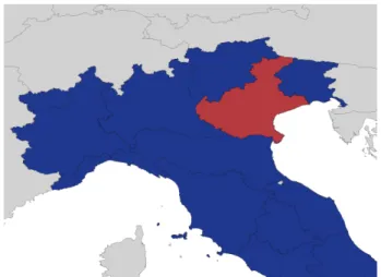
Fig. 1. Veneto is located in the north-eastern part of Italy and
bor-ders the Adriatic to its east. Toward the north and the south Veneto is shielded by the Alps and the Appennines, respectively.
nience sake. A detailed description of the LM is available in Doms and Sch¨attler (2004) and Doms et al. (2004). The cor-responding forecast product of the Italian LM LAMI, how-ever, were depicting the details of the flow quite accurately. The global model products were taken from the Integrated Forecast System (IFS) of the European Centre for Medium-range Weather Forecasting (ECMWF) on a Gaussian grid of mesh size 0.5◦, while the LAM products came from the Ital-ian version of the Lokal Modell (LAMI) on a grid of 7 km mesh size.
Observations were available from ARPAV’s automatic weather station (AWS) network, which totals roughly 200 stations, the C-band Doppler radar located on Mt. Grande (472 m a.s.l.) on the central part of the Veneto plains, and the Meteosat-8 HRV products. For the present analysis the following observations were used:
– AWS data for two meter temperature T2 mand ten meter
wind v10 mavailable every hour;
– radar quantitative precipitation estimates (QPE); – velocity azimuth displays (VAD), i.e. vertical wind
pro-files as derived from the Mt. Grande radar of ARPAV; and
– Meteosat-8 high-resolution visible (HRV) products for a
post-event estimation of the snow coverage in the plains. The case study approach along with phenomenological de-scription was chosen aiming at documenting the peculiarities of the meteorological situation.
3 3 March 2005 snowfall case over Veneto
3.1 Numerical forecast guidance
The case of the Mediterranean cyclone under consideration took place 3 March 2004, when an upper-level trough
deep-ened over Western Europe and intruded the Western Mediter-ranean area in the course of the day, giving rise to a surface lee cyclone in the Gulf of Genoa (not shown). By the end of the day the surface low propagated along the southern fringe of the Alps to the Northern Adriatic, where it was associated with a distinct southerly Sirocco flow.
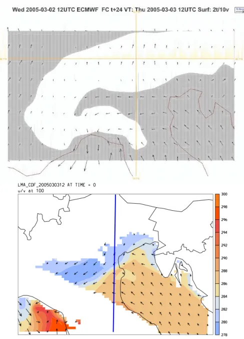
The ECMWF global model featured a uniform moderate Sirocco flow at all levels of the lower troposphere down the the surface level (Fig. 2 upper panel), hence bringing warm-moist air to the plains. The snowfall limit of this airmass was at several hundreds of meters above sea level, so that a forecast for the Veneto plains (10–20 m a.s.l.) based on the IFS called for rain rather than snow.
The surface conditions as forecast by the LAMI (Fig. 2 lower panel), on the other hand, drew a qualitatively differ-ent picture. While the flow in the LAMI was quite similar to the IFS’s at 1000 m above ground (not shown), at 100 m above ground a marked north-easterly flow emerged. By 3 March 18:00 UTC the surface low was located off the coast of Venice, with a well defined warm frontal signature at the surface along the coast extending east. The warm sector was, therefore, almost entirely confined to the sea, except for the southernmost part of Veneto, confining a cold sector north-easterly flow between the Adriatic and the Alps. Hence, a forecast based on the LAMI included elements necessary for snow to occur on the plains, in that the warm moist Sirocco flow was forced over a layer of cold air thick enough to avoid melting of the precipitation.
The difference between the IFS and the LAMI forecasts becomes even clearer in the vertical cross section (Fig. 3). At 18:00 UTC the thermal contrast between the distinct air-masses was further enhanced, yielding a 10 K difference in the equivalent potential temperature over some 50 km. Also, it is evident how the warm and moist southerly flow is forced upon the cold air, which effectively acts as a barrier well up-stream of the orographical obstacle.
3.2 Validating observations
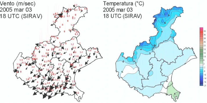
Figure 4 shows the surface observations of the ARPAV AWS network for 3 March 18:00 UTC. Indeed, the v10 mevidenced a rather marked north-easterly component, as well as the boundary to the Sirocco flow in the south-eastern corner of Veneto, a flow configuration which persisted for the entire duration of the precipitation event. The T2 mfield confirmed the cold air in the north-easterly flow and the warm air in the south east.
Moreover, the velocity azimuth display (VAD) of the ARPAV Mt. Grande radar, located some 70 km from the coast, revealed a distinct low-level jet over the central plain of Veneto with peak values up to 15 m/s and north-easterly direction (Fig. 5). Winds decreased with height from the maximum value at 500 m above ground to 1000 m, where the direction changed gradually to south-easterly, with largest vertical shear values in the lowest levels that the radar can sample.
Fig. 2. Upper panels shows ECMWF IFS +24 h forecast of the surface conditions valid at 3 March 12 UTC. Shaded areas denote values of
the T2 mabove 0◦, while the arrows denote the v10 m. Lower panel shows equivalent potential temperature (color shading, contour interval
2 K) and horizontal wind vectors at 100 m a.s.l. as forecast by the LAMI. As a matter of fact, for the sake of convenience, the data shown here are aLMo analyses, which for this case are very close to the LAMI +12 h and +18 h forecasts. The thick, solid line denotes the position of the vertical cross section shown in Fig. 3, whereas the white areas in denote missing data due to orography which is higher than 100 m.
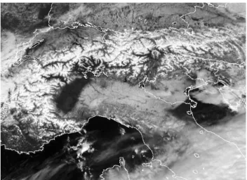
Figure 6 shows the high-resolution visible image of Meteosat-8 of the following day, i.e. 4 March 12:00 UTC, which very nicely depicts the marks of the snowfall event. Almost the entire Po Valley has been powdered with snow. The southernmost tip of Veneto and the Po Delta, however, received no snow, but rain only, consistent with the wind and temperature observations in Fig. 4, which document that this part was in the warm sector and affected by the Sirocco down to the surface.
4 Summary and Discussion
In this paper a case of a Northern Adriatic frontal passage is presented. The focus is placed on giving the forecaster a con-ceptual understanding of a complex flow situation which can be critical for the occurrence of snow in the Veneto plains. The main findings are as follows:
– the existence of a cold air pool or flow over the Veneto
plains, as depicted in the conceptual sketch shown in Fig. 7, is argued to be critical for snow to reach the ground, in that it forces the warm humid air above the
282 M. Monai et al.: Snow or rain on Veneto’s plain? -7.5 -5.0 -2.5 0 0 2.5 2.5 5.0 5.0 5.0 5.0 7.5 7.5 7.5 7.5 7.5 7.5 7.5 10.0 10.0 10.0 10.0 10.0 10.0 10.0 10.0 10.0 10.0 10.0 12.5 12.5 12.5 12.5 12.5 12.5 12.5 12.5 12.5 12.5 15.0 15.0 15.0 17.5 20.0 -27.5 -25.0 -25.0 -22.5 -22.5 -20.0 -20.0 -17.5 -17.5 -15.0 -15.0 -12.5 -12.5 -12.5 -10.0 -10.0 -7.5 -7.5 -5.0 -5.0 -2.5 -2.5 -2.5 0
APP.
PO V.
ALPS
Fig. 3. Vertical cross section as delineated in the lower panel of Fig. 2 of equivalent potential temperature (color shading, contour interval
2 K), temperature (thin lines, contour interval 2.5 K, solid/dashed lines above/below 0◦C), and meridional wind component (thick lines, contour interval 2.5 m/s, solid/dashed lines denote a southerly/northerly flow component). The figure stands for the +18 h forecast of LAMI valid for 3 March 18:00 UTC, but as in Fig. 2 the data shown here are aLMo analyses.
Fig. 4. ARPAV automatic weather station network data observed at 3 March 2005 18:00 UTC. The upper panel shows v10 m(numbers denote
Fig. 5. ARPAV Mt. Grande Doppler radar velocity azimuth display (VAD). The panels denote from left to right wind speed (m/s), wind
direction (◦), and vertical wind shear (m/s/100 m).
melting layer ahead of the orographic obstacle and pre-vents the snow from melting when reaching the ground;
– the precipitation distribution (not shown) exhibited a
maximum upstream of the pre-alpine and Alpine barrier in the region of Vicenza;
– the high-resolution limited area model LAMI did
suc-cessfully capture this mesoscale flow feature, while it was absent in the ECMWF global model forecast;
– an integrated meteorological observing system is crucial
for monitoring such a situation.
The north-easterly flow analyzed in the lowest part of the troposphere over the Veneto plains in a situation of prevalent meridional synoptic flow features distinct mesoscale charac-teristics. Classical cases of Bora in the region of interest usu-ally exhibit maximum wind speeds east and just downwind of the Dinaric Alps. Also, intensification of the Bora follow-ing the passage and south-eastward propagation of a northern Adriatic depression is quite common. Here, however, north-easterly surface winds in Trieste, a typical Bora site, were observerd to amount to about 5–6 m/s averaged over the en-tire period of interest, whereas winds around 6 m/s where ob-served on the south-western Veneto plains, for instance. The fact that in other typical Bora sites like Pula and Portoroz
the wind was moderate and from the southeast (not shown, but see lower panel of Fig. 2) is another indicator that the north-easterly flow over Veneto is not part of a classical Bora configuration. In addition, the low pressure centre was still situated on the northern Adriatic during and right after the precipitation episode with the southerly flow forced over the cold air.
The overall southerly flow tagged “Sirocco” in Fig. 7 was moderate and seemed, at least partially, blocked by the Alps, resulting in a flow reversal at the lowest levels. Due to the geography in the area the flow deflection acquired a north-easterly component (Buzzi, 2004) which may have enhanced the moderate north-easterly flow on the Veneto plains tagged “Bora” in Fig. 7. Evaporative cooling associated with the precipitation forced over the cold air pool may have con-tributed to maintain and intensify the cold air and so prevent the warm air to advance inlands. As a matter of experience, propagation of the warm air up to the foothills of the pre-alpine chain is the way more frequent case in similar syn-optic settings. However, this dynamical aspect needs further investigation, especially with respect to the characteristics of the pre-existing cold air pool and intensity and stratification of the meridional flow. Also, more such cases need to be identified and analyzed in order to undergird the findings.
284 M. Monai et al.: Snow or rain on Veneto’s plain?
Fig. 6. Meteosat-8 high-resolution visible product HRV over
north-ern Italy for 4 March 2005 12:00 UTC (obtained from EUMETSAT by way of the Italian Air Force Meteorological Service).
Fig. 7. Conceptual sketch of the flow situation. As described in
the text, the cold air flow tagged “Bora” may be a combination of a Bora flow and a barrier jet originating from a flow reversal due to blocking of the warm air flow tagged “Sirocco”.
Buzzi for pointing out the issue of the flow reversal, and Gabriele Formentini for preparing Meteosat-8 and VAD images.
Edited by: V. Kotroni and K. Lagouvardos Reviewed by: anonymous referee
References
Bougeault, P., Binder, P., Buzzi, A., Dirks, R., Kuettner, J., Houze, R., Smith, R. B., Steinacker, R., and Volkert, H.: The MAP Special Observing Period, Bull. Am. Meteor. Soc., 82, 433–462, 2001.
Brzovic, N.: Factors affecting the Adriatic cyclone and associated windstorms, Contr. Atmos. Phys., 72, 1, 51–65, 1999.
Buzzi, A.: Heavy precipitation and Alpine orography, Proceedings of the International Workshop on timely warnings of heavy pre-cipitation episodes and flash floods, Ljubljana, 21–22 October 2004, 12pp., 2004.
Doms, G. and Sch¨attler, U.: A description of the nonhydrostatic regional model LM: Part I: Dynamics and numerics, http:// cosmo-model.org, 2004.
Doms, G., F¨orstner, J., Heise, E., Herzog, H.-J., Raschendorfer, M., Schrodin, R., Reinhardt, T., and Vogel, G.: A descrip-tion of the nonhydrostatic regional model LM: Part II: Physical parametrization, http://cosmo-model.org, 2004.
Ivancan-Picek, B. and Tutis, V.: A case study of a severe Adriatic bora on 28 December 1992, Tellus, 48A, 357–367, 1996. Miglietta, M. and Buzzi, A.: A numerical study of moist stratified
flow regimes over isolated topography, Q. J. R. Meteorol. Soc., 130, 1749–1770, 2004.