HAL Id: hal-03008882
https://hal.archives-ouvertes.fr/hal-03008882
Submitted on 17 Nov 2020HAL is a multi-disciplinary open access archive for the deposit and dissemination of sci-entific research documents, whether they are pub-lished or not. The documents may come from
L’archive ouverte pluridisciplinaire HAL, est destinée au dépôt et à la diffusion de documents scientifiques de niveau recherche, publiés ou non, émanant des établissements d’enseignement et de
10 Be exposure age for sorted polygons in the Sudetes
Mountains
Zbyněk Engel, Marek Křížek, Regis Braucher, Tomáš Uxa, David Krause
To cite this version:
Zbyněk Engel, Marek Křížek, Regis Braucher, Tomáš Uxa, David Krause. 10 Be exposure age for sorted polygons in the Sudetes Mountains. Permafrost and Periglacial Processes, Wiley, 2020, �10.1002/ppp.2091�. �hal-03008882�
10
Be exposure age for sorted polygons in the Sudetes Mountains 1
Zbyněk Engela,*, Marek Křížeka
, Régis Braucherb, Tomáš Uxaac, David Krausead, AsterTeamb 2
3
a
Charles University, Faculty of Science, Department of Physical Geography and Geoecology, 4
Prague, Czech Republic 5
b
CEREGE CNRS Aix Marseille Univ., IRD, INRAE, Collège de France, Aix-en-Provence, 6
France 7
c
Academy of Sciences of the Czech Republic, Institute of Geophysics, Department of 8
Geothermics, Prague, Czech Republic 9
d
The Krkonoše Mountains National Park Administration, Vrchlabí, Czech Republic 10
AsterTeam: Georges Aumaître, Didier Bourlès, Karim Keddadouche 11
* Corresponding author. Tel.: +420 22 195 1373. E-mail address: engel@natur.cuni.cz. 12
13
Abstract 14
Patterned ground landforms represent the most common phenomenon of periglacial 15
environment and its large sorted forms belong to the few morphological indicators of former 16
permafrost distribution. Relic forms of patterned ground are widespread on high-elevated 17
surfaces in the central European uplands, providing the evidence of regional periglacial 18
conditions in the past. However, the timing of these landforms as well as their potential for 19
paleoclimate reconstructions, have remained unexplored. In this paper, we present 10Be 20
exposure ages from the large sorted polygons sampled at four sites in the Sudetes Mountains, 21
the highest part of the central European uplands. These results indicate that these landforms 22
started to form at the end of MIS 3 and the main phase of their formation occurred between 30 23
and 20 ka. This research confirms the hypothesis of patterned ground formation within the 24
Weichselian glacial (115ka-10ka ?) and suggests that earlier landforms are not preserved in 25
the Sudetes. The recognised period of enhanced periglacial activity coincides with a 26
prominent cold interval identified earlier in both regional and northern-hemispheric proxy 27
records. 28
1 Introduction 29
Cryogenic sorted patterned ground refers to the arrangement of segregated fine and coarse 30
material that form at the ground surface as a result of differential frost heave and buoyancy-31
driven soil circulation.1 The resulting forms are more or less symmetric features among which 32
circles and polygons are most common. The polygonal pattern reflects uneven penetration of 33
freezing planes into the ground, displacement of clasts from concentrations of finer soil 34
toward pattern margins, and lateral interaction of adjacent fine cells.2 Small-scaled circles and 35
polygons (<1m in diameter) form in seasonally-frozen ground, but larger sorted forms are 36
found only in areas underlain by permafrost.3 Relict forms of large sorted forms thus provide 37
evidence for the former existence of permafrost and allow rough estimates of paleoclimatic 38
conditions.4 39
The distribution of cryogenic sorted patterned ground has been frequently used for spatial 40
reconstructions of periglacial environment during the cold stages of the Quaternary as their 41
distinct pattern can be easily identified in the field and remotely sensed data. Moreover, 42
dimensions of large (> 1 m wide) sorted forms of patterned ground indicate the thickness of 43
former active-layer that corresponds to the depth of sorting and landform width.5 The 44
paleoclimatic interpretation of patterned ground has been mostly considered limited because 45
of the complex history of their formation and the possible influence of non-climate-related 46
local factors.6 However, large sorted forms indicate lack of a thick snow cover, frequent 47
freeze-thaw cycles, and air temperature thresholds required for differential sorting and frost-48
heave.7 Nowadays, large sorted forms of patterned ground are active in the permafrost areas 49
with mean annual air temperature (MAAT) lower than −6 °C to −3 °C.8, 9 Hence, these 50
landforms can, when constrained by geochronological data, provide insights into Quaternary 51
climatic conditions. 52
53
Unfortunately, there is still no robust approach for the dating of patterned ground, despite the 54
recent advances in geochronology. The main problem for dating these structures results from 55
the complex history of their formation as they can develop over a short/long time span and/or 56
during multiple cold events.10 Large sorted polygons are products of recurrent freezing and 57
thawing of the active layer, which causes upward movements of coarse clasts from the 58
permafrost table and their subsequent migration towards the margins of the polygons.11, 12 59
Under prolonged freeze-thaw conditions, the boulders forming the margins may be tilted due 60
to lateral squeezing of adjacent polygons.13 Although this process can shorten the exposure 61
age of the boulders it still represents the period of polygon formation. If the frequency of 62
freeze-thaw cycles drops back tothe non-permafrost conditions, the supply of clasts via frost 63
heave and lateral sorting ceases and large boulders at the margin of the polygons stabilize, 64
attesting to the last time of their activity. Smaller pattern may eventually form in the centre of 65
the inactive polygons at a later time if environmental conditions become suitable.3 66
Since the 1990s, radiocarbon, luminescence and terrestrial in situ-produced cosmogenic 67
nuclides (TCN) dating methods have been applied on patterned-ground forms to determine 68
their ages. Radiocarbon ages were reported mostly for non-sorted patterned ground, especially 69
earth hummocks, rich in organics.14 Only few radiocarbon data were obtained for sorted 70
patterned ground15-17 that usually contains a small amount of organic material. Moreover, this 71
material may have formed earlier or later than the landform itself.16 Thermoluminescence and 72
optically stimulated luminescence (OSL) dating has been used for the dating of non-sorted 73
circles, stripes and polygons18-20 but a successful application remains challenging.21 Apart 74
from the issues related to the polycyclic nature of these features,19 the possible incorporation 75
of incompletely bleached grains, and fluctuations of the water content after sedimentation of 76
the material complicates the interpretation of the luminescence data.22 The application of TCN 77
in the dating of patterned ground is still rare. The method has only been used to estimate the 78
timing of poorly sorted patterns based on the dating of underlying rock glaciers.23, 24 and to 79
obtain Schmidt-hammer exposure ages for sorted circles and stripes.6, 25The most frequent 80
applications of TCN in the periglacial landscape include the determination of ‘periglacial 81
trimlines’,26
the timing of rock glaciers27 and boulder fields.28 82
In this paper, we aim at constraining the timing of sorted polygons in the Sudetes Mountains, 83
the highest section of the central European uplands. This region is characterized by large 84
surfaces of low relief above 1200 m a.s.l. (referred to as summit planation surfaces in this 85
paper)29 with well-developed periglacial landforms. Among these landforms, sorted patterned 86
ground phenomena were recognised first because of their distinctive morphology and 87
widespread distribution.30 An earlier hypothesis relates their origin with past glacial cycles 88
and attributes most of the preserved forms to the culmination phase of the last glacial period.31 89
An alternative view suggests that most patterned ground in the Sudetes formed during the 90
Lateglacial period.32 In either case, the chronology of these landforms and paleoclimatic 91
conditions during the period of their formation remain uncertain. In order to constrain the 92
timing of the formation of large sorted polygons and to infer paleoclimate conditions for this 93
period we have analysed their distribution and morphology in the Krkonoše and Hrubý 94
Jeseník Mountains, the highest parts of the Sudetes . 24 new 10Be surface exposure ages from 95
four sorted polygon assemblages were produced and ., , the established chronology was 96
compared with a local set of exposure ages reported for glacial and periglacial landforms and 97
with the existing records of paleoenvironmental conditions in central Europe. 98
2 Study area 99
The Sudetes Mountains on the Czech/Polish boundary represent a 340 km long eastern section 100
of the central European uplands that stretch along 50° N. During the Quaternary glaciations, 101
the Sudetes Mountains were located within the periglacial zone between the Fennoscandian 102
ice sheet and ice cap over the Alps (Fig. 1, inset). The width of the zone ranged from 430 km 103
in the Last Glacial Maximum (LGM) to more than 1300 km during the Middle Weichselian 104
interstadial. Periglacial processes and loess deposition dominated the development of this 105
zone over cold stadial episodes. An extensive loess deposition belt was formed in the northern 106
part of the zone while a more scattered loess cover arose at the southern front of the Sudetes 107
Mountains below 450 m a.s.l.35 Periglacial processes have been most intense on summit 108
planation surfaceswhere the annual precipitations were estimated to range from 500 to 700 109
mm during the LGM36 and the MAAT was 7 to 10°C lower than at present.37 During the last 110
glaciation, cirque and valley glaciers modified the central part of the ranges38 but periglacial 111
landscape has retained larger extent. 112
The Sudetes Mountains are located in a transitional zone between areas dominated by the 113
oceanic climate and the continental type regimes. The precipitation on summit planation 114
surfaces decreases from the Krkonoše Mountains in the western part of the Sudetes Mountains 115
(>1500 mm per year)39 to the Hrubý Jeseník Mountains near the eastern margin of the range 116
(1200–1300 mm per year).40 The MAAT for the period 1961–1990 ranged from 0.4°C at the 117
Sněžka weather station (1603 m a.s.l.) in the Krkonoše Mountains and 0.9°C at the Praděd 118
station (1492 m a.s.l.) in the Hrubý Jeseník Mts. to approximately 3°C at an elevation of 1200 119
m a.s.l.41 Westerly winds prevail within the Sudetes Mountains transporting snow from the 120
summit plateaus to leeward slopes.42 121
The Krkonoše Mountains comprise a WNW-ESE oriented main (Silesian) ridge built of the 122
mid-Carboniferous granites (~320–315 Ma) and a parallel southern (Bohemian) ridge at the 123
contact between the plutonic complex and Neoproterozoic to Lower Palaeozoic metamorphic 124
rocks.43 The ridges delimit the relics of high-elevated (1350–1500 m a.s.l.)44 planation 125
Commentaire [Régis1]: Already written three lines before.
surfaces (Fig. 1a and 2a) formed as a result of slow weathering and long-term denudation that 126
probably started around 75 Ma.46 The Hrubý Jeseník Mountains consist of Keprník and Desná 127
Domes oriented approximately NE-SW (Fig. 1b). Both domes are built by a Cadomian 128
crystalline basement imbricated with metamorphosed Devonian volcano sedimentary 129
complexes.47 The domes have well-developed summit planation surfaces at 1300–1460 m 130
a.s.l.,48 which are more extensive in the southern part of the Desná Dome (Fig. 3a). Planation 131
surfaces in both the Krkonoše and Hrubý Jeseník Mountains are covered with periglacial 132
deposits among which sorted forms of patterned ground prevail.45 133
The four studied sites are located in high-elevated parts of the Sudetes Mountains. Vysoké 134
Kolo (1509 m a.s.l.), the highest granite elevation in the western Krkonoše Mountains, and 135
quartzite-dominated Luční hora (1555 m a.s.l.) on the Bohemian Ridge (Fig. 1a) represent the 136
highest summit planation surface in the Sudetes Mountains. Břidličná hora (1358 m a.s.l.) and 137
Větrná louka (1250–1270 m a.s.l.) consist of phyllites and represent the southern part of the 138
Hrubý Jeseník Mountains (Fig. 1b). Břidličná hora belongs to the highest elevations on the 139
Desná Dome whereas Větrná louka is located on a lowered planation surface on a side ridge 140
(Fig. 3). Products of in situ weathering dominate at all sites and small sections of exposed 141
bedrock are present only on Luční hora. All sites except Větrná louka are located in the zone 142
of limited vegetation above the timberline (Fig. 1 and 3e). 143
3 Methods 144
3.1 Morphological analyses and boulder sampling 145
We selected four study sites with the best-developed and undisturbed sorted polygons in the 146
Sudetes Mountains for morphological analyses and 10Be sampling. The length, width and 147
height of the 81 sorted polygons were measured at these sites.The height is defined as the 148
maximum vertical distance between the lowest point at the polygon border and the highest 149
point at its updomed centre.49 Between-site differences in the height and width of the sorted 150
polygons were assessed by a one-way analysis of variance (ANOVA), and tested using an F-151
test at the significance level p = 0.05. The length of the sorted polygons was excluded from 152
the ANOVA analyses because this parameter can relate to the surface inclination and thus it 153
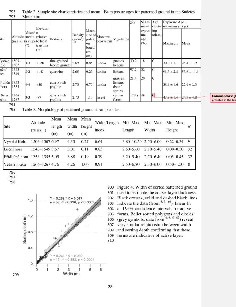
can reflect other factors, such as solifluction.50 The width of the polygons was used to roughly 154
estimate the thickness of the past active layer based on the regression equation (Fig. 4) for a 155
set of published paired data.4,5,9,51-67 156
The sorting depth for polygons and thickness of weathered rock at study sites were 157
determined using electrical resistivity tomography. Soundings were carried out across the 158
given polygon assemblage between the nearest edges of the given summit flat. The method 159
was applied at multiple four-electrode arrays with 2-m spacing between the electrodes using 160
the Wenner-Schlumberger measuring method.68 The obtained apparent resistivity data were 161
subjected to the geophysical inversion procedure (L1-norm) in RES2DINV software 162
(Geotomo, Malaysia). 163
We sampled six boulders per site to increase the possibility of deriving a robust 10Be 164
chronology. At each site, we collected samples from two to three individual sorted polygons. 165
The samples were collected preferentially from the largest upright boulders located in a 166
border of a sampled undisturbed polygon. This approach limits the possibility of the tilting of 167
boulders after their active upfreezing/frost heaving and reduces the effects of snow and 168
vegetation cover.69 The samples were collected using a chisel and a hammer; the samples 169
were taken from the sampled surface to the depth of 2 to 7 cm. The dip/orientation of the 170
sampled surfaces was measured with a clinometer and a compass and their location/altitude 171
was determined with GPS. The characteristics of sampled boulders and study sites are given 172
in Table 1 and 2, respectively. 173
3.2 10Be methodology 174
The samples were crushed, sieved and cleaned with a mixture of HCl and H2SiF6. The
175
extraction method for 10Be70, 71 involves isolation and purification of quartz and elimination of 176
atmospheric 10Be. A weighed amount (~0.1 g) of a 3025 ppm solution of 9Be was added to the 177
decontaminated quartz. Beryllium was subsequently separated from the solution by successive 178
anionic and cationic resin extraction and precipitation. The final precipitates were dried and 179
heated at 800 °C to obtain BeO, and finally mixed with niobium powder prior to the 180
measurements, which were performed at the French Accelerator Mass Spectrometry (AMS) 181
National Facility ASTER (CEREGE, Aix en Provence). 182
The beryllium data were calibrated directly against the STD-11 beryllium standard using a 183
10
Be/9Be ratio of 1.191 ± 0.013·10−11.72 Age uncertainties include an external AMS 184
uncertainty of 0.5%,73 blank correction and 1σ uncertainties. The 10Be/9Be measured blank 185
ratio associated to the samples presented in this paper is 3.618·10−15. A density of 2.5 g cm-3 186
was used for all samples. A sea-level, high-latitude spallation production of 4.01 ± 0.18 at g– 187
1
·yr–1 74 was used and scaled for latitude and elevation using Stone75 scaling scheme. The 188
surface production rates were also corrected for the local slope and topographic shielding due 189
to the surrounding terrain.76 Shielding from snow was estimated using an average snow 190
density of 0.3 g·cm–3 and an estimated snow thickness and duration at sample sites.77 These 191
values were derived from the mean thickness and duration of snow cover during the years 192
1961–1990 at 14 weather stations (445−1410 m a.s.l.) in the Sudetes Mountains. As the snow 193
cover is unevenly distributed and its variation since the exposure of sampled surfaces is 194
unknown, the real effect of snow shielding remains uncertain. However, most of samples 195
were extracted from windswept sites without vegetation and we therefore suspect that 196
temporal variation in snowfall has had a minor effect on snow conditions at these sites. 197
10
Be concentrations were modelled using the equation: 198
199
(1) 200
where C(x, ε, t) is the nuclide concentration as a function of depth x (g·cm–2), ε the denudation
201
rate (g·cm–2·yr–1), t the exposure time (yr) and λ the radioactive decay constant (yr–1). Pspall
202
and Pµ are the relative production rates due to neutrons and muons, respectively. Λn and Λμ
203
are the effective apparent attenuation lengths (g·cm–2), for neutrons and muons, respectively. 204
The muon scheme follows Braucher et al.78 205
To estimate minimum exposure ages, denudation was set to zero whereas the exposure time 206
was supposed to be infinite to infer maximum denudation rates. In that latter case, it is 207
possible estimating the time (integration time, noted Tint.) needed to reach the steady state
208
concentration using a modified equation based on the approach of Lal79 which do not consider 209
muon contributions; the modified equation is: 210 𝑇𝑖𝑛𝑡. = %𝑃𝑠𝑝𝑎𝑙𝑙 𝐿𝑛(2) 1387000 + 𝜖 160 + %𝑃µ𝑆𝑙𝑜𝑤 𝐿𝑛(2) 1387000 + 𝜖 1500 + %𝑃µ𝐹𝑎𝑠𝑡 𝐿𝑁(2) 1387000 + 𝜖 4320 (2) 211 . µ ( , , ) P . n 1 exp . 1 exp x x spall x t n n P C e t e t
where %Pspall, %PµSlow and %PµFast are the percentage contributions of neutrons, Slow 212
and Fast muons respectively in the total production and 160, 1500 and 4320 g.cm-2 their 213
respective attenuation lengths. 214
3.3 Data treatment 215
We assess the distribution of exposure ages obtained at individual sample sites, compare the 216
arithmetic means and standard deviations calculated for four age populations, and interpret the 217
chronological data with exposure ages reported from the Sudetes Mountains in previous 218
studies. 219
We first analyse the scatter in exposure-age data sets for each sample site because the age 220
distribution reflects the exposure history of sampled surfaces and indicates main sources of 221
geological uncertainties - cosmogenic-nuclide inheritance and disturbance of boulders after 222
emplacement.80 Among a group of sample, a sample with inherited 10Be can be identified by a 223
higher concentration yielding to older age than the mean of the remaining ages. By contrast,a 224
significant younger age may indicate incomplete exposure of the sampled boulder. The 225
distribution of the exposure ages obtained for the given sample site and scatter in the age 226
groups were approximated using the reduced chi-square statistics (𝜒𝑅2) and a standard
227
deviation (SD) to the arithmetic mean exposure age ratio. Following the procedure presented 228
by Blomdin et al.,81 age groups that have 𝜒𝑅2 ≤ 2 are classified as well-clustered, groups that
229
show 𝜒𝑅2 > 2 but SD ≤15% of the mean exposure age are considered as moderately-clustered, 230
and groups that show 𝜒𝑅2 > 2 and SD >15% of the mean age are designated as
poorly-231
clustered. 232
Subsequently, we calculated an arithmetic mean and standard deviations (1s) for each site, 233
compare these values, and assessed their relevance for regional estimate of polygon 234
chronology. When the age ranges of two or more sample sites overlap within their analytical 235
uncertainties we consider them representative as a regional interval of the sorted polygon 236
formation. We compare this interval with regional glaciation chronology and we interpret the 237
data with respect to exposure ages reported for periglacial landforms in the Sudetes 238
Mountains.82, 83 An apparent age that differs significantly from the resulting age range is 239
excluded from chronological consideration. A number of factors can cause apparent exposure 240
ages of the sampled landforms and these are discussed in section 5.1. 241
242
Commentaire [Régis2]: In table 2 a class cluster is still present ( Class C) Is it mormal?
4 Results 243
4.1 Morphology of sorted polygons 244
The sorted polygons occur on flat or gently inclined surfaces (Fig. 2bcde, 3bcde) with the 245
median slope around 3° (Table 2). The length and width of the polygons range between 2.5‒ 246
10.5 m and 2.1‒6.4 m, respectively (Table 3). The sorted polygons on Vysoké Kolo (VK) 247
have the largest average length (6.97 m), followed by the polygons on Břidličná hora (BR) 248
and Větrná louka (VL), while the patterns with the smallest average length (3.67 m) lie on 249
Luční hora (LH). The polygons on Luční hora have significantly smaller width (Fig. 5) than 250
the polygons at other study sites (i.e. LH vs VK: F(1.41) = 26.643, p = 0.00001; LH vs BR: 251
F(1.62) = 19.491, p = 0.00004; LH vs VL: F(1.38) = 14.576, p = 0.00048). The sorted 252
polygons with the largest average height lie on Větrná louka (Table 3, Fig. 5), which 253
significantly differs from other study sites (i.e. VL vs LH: F(1.38) = 260.24; p < 0.00001 VL 254
vs VK: F(1.17) = 71.698, p < 0.00001; VL vs BR: F(1.38) = 201.41; p < 0.00001). 255
4.2 Regolith thickness 256
The high electrical-resistivity zones of more than ca. 60,000 Ω·m at the Vysoké Kolo, Luční 257
hora, and Břidličná hora sites (Fig. 6a, 6b and 6c) are associated with the presence of air-filled 258
debris. By contrast, the resistivity of the weathering mantle at Větrná louka is lower (Fig. 6d) 259
because this site lies below the alpine timberline and is covered with a thick top soil layer, 260
which supports the cavities between the boulders with fine-grained materials. In addition, the 261
quartzite vein crossing the Větrná louka site causes a slight bedrock protrusion, while at other 262
locations the bedrock is mostly parallel to the ground surface. The regolith at the Vysoké 263
Kolo, Břidličná hora, and Větrná louka sites is two to three times thicker than on Luční hora 264
where regolith/bedrock transition is around 2 m (Fig. 6b) below the ground surface. The small 265
depth of bedrock at this site is constrained by the nearest cryoplanation terrace located 3 m 266
lower. 267
4.3 Exposure ages 268
For all studied sites, surface exposure age are scattered (Table 1) and age groups are poorly 269
clustered (Table 2). Exposure ages obtained for the patterned ground on Vysoké Kolo yield a 270
mean age of 25.4 ± 1.9 ka and an oldest age of 30.3 ± 1.1 ka. This boulder group has the 271
smallest scatter and ages range from 19 to 30 ka. Boulder group from the sorted polygons on 272
Luční hora have a mean age of 53.6 ± 11.4 ka. The exposure ages from this summit flat show 273
the largest scatter of all the study sites, ranging from 91.3 ± 2.8 ka to 9.0 ± 5.6 ka. Exposure 274
ages obtained on Břidličná hora yield a mean age of 28.0 ± 1.0 ka and a maximum age of 38.1 275
± 1.6 ka. This oldest age is significantly older than the calculated mean age but remaining 276
ages fall within a narrow range of 23‒29 ka. Boulder group from Větrná has a mean exposure 277
age of 24.3 ± 4.8 ka and an oldest age of 47.9 ± 1.4 ka that is an obvious outlieraccording to 278
the χ2 criterion. 279
4.4 Steady-state denudation rates 280
Considering the possibility that all samples have reached the denudational steady state (time 281
being consider as infinite in eq. 1), the measured 10Be concentrations may help to estimate 282
maximum steady state denudation rates. The highest values were obtained for the Větrná 283
louka site where all but one (VL2) samples yield maximum steady state denudation rates 284
ranging from 30 to 43 mm/ka. The denudation rate of 79.3 ± 49.4 mm/ka was calculated for 285
the sample LH4 but large uncertainty precludes robust interpretation of this value. Moreover, 286
other samples from the Luční hora site yield lower denudation rates than samples collected at 287
the remaining study sites (Table 1). 288
5 Discussion 289
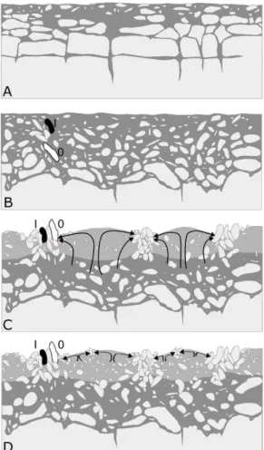
5.1 Exposure age interpretation and uncertainties 290
The scatter in age groups indicates that some sampled boulders experienced complex 291
exposure history or post-exposure disturbance. An observed distribution of six exposure ages 292
is affected by the presence of one or two underestimated ages and one overestimated age at all 293
but one sample site. A significantly older sample age than the mean exposure age calculated 294
for the landform results from cosmogenic-nuclide inheritance.84 The most probable reason for 295
inherited nuclide concentration in boulders that form the margins of sorted polygons is their 296
initial position at shallow subsurface depth affected by cosmic-ray flux. The cosmogenic-297
nuclide production decreases rapidly with depth and it is largely attenuated below ~1 m 298
depth.85 Boulders located below fine-grained regolith in this thin subsurface zone (Fig. 8B) 299
contain inherited 10Be from a period prior to the frost-heave event and they will show 300
apparently older age than boulders with zero inherited nuclide concentration frost-heaved 301
from greater depths. An alternative scenario that could lead to inheritance deals with the 302
repeated phase of polygon formation and emplacement of boulders that hadexperienced 303
previous exposure at the margins of former polygons. However, this scenario is less probable 304
as most of these boulders disintegrate over the period between two subsequent cold stages and 305
similar or higher freeze-thaw activity would be necessary to rearrange existing polygons. 306
The presence of apparently younger boulders in the margins of sorted polygon could be 307
attributed to post-exposure tilting of sampled surfaces87 rather than to surface erosion or 308
disintegration because only boulders without signs of erosion or fractures were sampled. The 309
post-exposure shielding of sample sites by ice or snow cover can be excludedfrom this 310
consideration too. Glaciers were confined to cirques and valleys during the LGM82 and 311
hypothetic plateau ice fields were suggested to cover high elevations except for wind-swept 312
top of the ridges.88 The presence of permanent snow cover is rather improbable because of 313
reduced precipitation (25–75%) in cold stages37, 89 and more effective deflation by enhanced 314
winds.36 Finally, the younger age of particular boulders cannot result from mass-shielding by 315
vegetation and/or soil cover that is evenly spread over the sample sites. 316
The obtained chronological data suggest that the large sorted polygons in the Sudetes 317
Mountains developed during the last glacial period. Considering relatively small areal extent 318
of the Sudetes Mountains, narrow elevation range of sample sites, and similar topographic and 319
climate conditions at these sites, the period of formation of large sorted polygons could have 320
occurred around the same time throughout the Sudetes. However, the summed probability 321
density distribution of the obtained 10Be exposure ages is bimodal with a main peak centred 322
on 25 ka and a minor increase around 64 ka (Fig. 7, black curve). Themain peak indicates 323
that the formation of sorted polygon started no later than 30 ka, reached a climax around 25 324
ka, and ceased after 18 ka. The second modelled peak reflects high levels of in situ produced 325
10Be in samples from the Luční hora site. These samples seem to be affected by inheritance as
326
indicated by apparently older mean age (53.6 ± 11.4 ka) compared to other sites (24.3 ± 4.8 ka 327
to 27.9 ± 2.3 ka). The possible reasons for the inheritance are discussed below. The reduced 328
dataset (n = 18) without exposure ages from Luční hora yields the mean exposure age of 25.0 329
± 0.4 ka (Fig. 7, grey curve). 330
The largest scatter in the age group from Luční hora confirms that inheritance must be 331
considered at this site. The exposure age of 91.3 ± 2.8 ka is the oldest within the whole 332
dataset, and the apparent mean age is significantly older than the timing of the established 333
main phase of polygon formation. The inheritance at this site may be tentatively attributed to 334
the quartzite bedrock and poorly developed regolith cover. Despite the presence of surface 335
features caused by differential weathering, the quartzite is more resistant to physical 336
weathering and erosion than granite and phyllite at other sample sites. The hardness of the 337
massive quartzite and considerably reduced surface lowering of landforms built by this rock 338
were reported from many regions including the Sudetes Mountains.32, 90 The effect of the rock 339
hardness on an exposure age was observed by Guido et al.,91 who reported a significantly 340
older exposure age (30.1 ka) for a quartzite knoll compared to ages from other rock types 341
(12.3 to 17.1 ka). 342
The hardness of the quartzite exerts control on the rate of weathering that is much lower 343
compared to weathering rate of granite and phyllite bedrock. As a result, a thin layer of 344
regolith has formed on Luční hora where bedrock lies only around 2 m below the ground 345
surface. By contrast, 4 to 9 m of weathered rock cover the bedrock at the remaining study 346
sites (Fig. 6). The sorting depthcorresponds with the thickness of regolith cover ranging from 347
less than 0.5 m on Luční hora to around 1.4 m on Břidličná hora.92, 93
Considering the mean 348
attenuation path length of neutrons in rocks84 and the depth of boulders (>0.5 m) before the 349
initiation of polygon formation on Luční hora, the relatively small boulders at this site contain 350
a substantial inherited nuclide component. By contrast, larger boulders that form polygons at 351
other sites (Table 2) have significantly less inherited 10Be as these were frost heaved from the 352
depth of more than 1.4 m. 353
The high fraction of boulder ages with inheritance indicate that exposure dating should be 354
applied on polygon boulders with caution. The age uncertainty resulting from the effects of 355
vegetation and snow cover shielding seems to be of minor importance. All sample sites except 356
Větrná louka are located above the timberline in the zone of limited vegetation and snow 357
cover that is effectively transported from the summit flats by the prevailing westerly winds.42 358
The timberline increased to its current position in the Sudetes Mountains during the early 359
Holocene, and forest has covered Větrná louka site at least over the last 8 ka.94
Considering 360
that boreal forest can reduce the cosmic ray flux by 2.3 ± 0.6%,95 the estimated timing of 361
polygons at this site could be underestimated only by a few hundred years. 362
5.2 Paleoenvironmental implications 363
The exposure ages indicate that large sorted polygons in the Sudetes Mountains formed 364
during the Upper Pleniglacial (34.8–14.7 ka)96 after a period of unstable climate in the second 365
part of MIS 3.97, 98 The onset of the polygon formation corresponds to the Greenland sub-366
stadial GS-5.1 (30.6–28.9 ka)99 and the main activity of these landforms reflects extremely 367
cold and relatively wet conditions in the Northern Hemisphere during the stadial GS-3 (27.5– 368
23.3 ka).100 The period of polygon formation overlaps with the range of 30–24 ka (Fig. 9), 369
which is considered as the period of the maximum extension of permafrost (Last Permafrost 370
Maximum, LPM)111 in Western Europe during the last glacial cycle.102 The timing of the 371
dated polygons is in line with the two (35–31 and 22–20 ka) out of four main phases of 372
periglacial activity in Britain lowlands,22 and corresponds to some phases (30.0 ± 2.5, 24.0 ± 373
1.1 and 20.7 ± 0.7 ka)of ice-wedge activity in France.102 374
The onset of differential frost heave in the Sudetes coincides with the pre-LGM period of 375
periglacial conditions indicated recently by 10Be exposure ages (Fig. 9). The exposure age of 376
36.5 ± 2.1 ka and 29.7 ± 2.1 ka reported for a summit tor and ploughing block, respectively, 377
delimit the interval of bedrock disintegration and enhanced solifluction in the Krkonoše 378
Mountains (Fig. 9).82 Four exposure ages (84.3 ± 3.8 to 26.8 ± 2.6 ka) retrieved recently for a 379
block slope adjacent to the Větrná louka site constrain the pre-LGM timing of cold 380
environments in the Hrubý Jeseník Mountains.83 At that time, permafrost reached its 381
maximum extent and thickness (220–250 m) as indicated by the subsurface post-cryogenic 382
structures near the eastern boundary of the Sudetes Mountains,112 the model-based estimates36 383
and the cryogenic cave carbonates.113 The size of polygons dated in this study implies active-384
layer thickness of 0.9–1.6 m. This range is consistent with the summer thawing to the depth of 385
1 m suggested by Jahn114 for LGM interval. 386
The occurrence of sorted polygons indicates cold conditions and lack of thick snow cover on 387
the upper slopes of the Sudetes Mountains between 30 and 18 ka. Considering the most 388
respected temperature threshold for the sorted polygon formation, the MAAT was lower than 389
–4 °C.9
The derived palaeotemperature represents maximal value for elevation range of 1210– 390
1270 m a.s.l. where dated polygons are preserved at Větrná louka site. Assuming the near-391
surface lapse rate in the lower troposphere (0.65 K/100 m), the MAAT on the summit flats 392
around 1550 m a.s.l. was probably lower than –6 °C. The estimated temperature range is 393
higher than the MAAT estimates for LGM that vary between –8 and –10 °C. 37, 115 However, 394
the palaeotemperatures derived in this study must be regarded as maximal thresholds only 395
because sorted polygons are also found at lower elevations within the Sudetes Mountains. 396
Regional amelioration of the climate after around 18 ka101 led to the gradual degradation of 397
permafrost in the Sudetes Mountains. 36 The intensity of frost action decreased allowing only 398
for cryoturbation, solifluction and limited sorting of fine-grained covers.116 The periglacial 399
activity increased again at the end of the Lateglacial period when the climate cooled and 400
permafrost re-aggraded.101, 117 The exposure ages reported for moraines (13.5 ± 0.5 to 12.9 ± 401
0.7 ka) and pronival ramparts (13.8 ± 0.4 ka) in the Krkonoše Mountains indicate glacier re-402
advance and enhanced frost action (Fig. 9).82 At that time, frost sorting and solifluction were 403
probably reactivated.117 Small sorted patterns observed in the large dated polygons on Luční 404
hora summit flat may be tentatively attributed to that period though their later formation 405
cannot be excluded.49 During the Holocene, the frost action has been limited to cryoturbation, 406
solifluction and sorting of sandy covers in deflation areas with thin snow cover.50 407
5.3 Summit flat denudation 408
The observed differences in the maximum steady state denudation rates between the sample 409
sites may reflect varying topography and bedrock conditions that control the intensity of 410
surface processes on summit planation surfaces. The denudation rates <20 mm/ka obtained 411
for the Luční hora site represent the highest summit planation surface in the Sudetes 412
Mountains underlain by quartzite (Table 2). Well-preserved morphology and small elongation 413
of the sorted polygons on this near-horizontal site indicate low rate of weathering and slope 414
processes. Higher values of denudation rates inferred for Vysoké Kolo and Břidličná hora are 415
consistent with less resistant bedrock (granite and phyllite) and more intense surface transport. 416
The latter assumption is supported by the lower values of width/length index calculated for 417
the preserved sorted polygons (Table 3). The highest denudation rates (~40 mm/ka) were 418
obtained for the Větrná louka site, which represents a lowered planation surface on a side 419
ridge build by phyllites. 420
The observed denudation rates are comparable to the values derived from cosmogenic 421
nuclides for bedrock outcrops in mid-latitude mountain regions. The low values determined 422
for the highest planation surface in the Krkonoše Mountains correspond with the denudation 423
rates reported for summit flats in Western U.S. mountain ranges (2–19 mm/ka),119 ridgeline 424
outcrops in the Appalachian Mountains (~9 mm/ka),120 and arête-shaped ridges in the 425
Pyrenees (9–21 mm/ka).121 The higher intensity of denudation determined for the lower 426
planation surfaces in the Sudetes ranges is in line with the denudation rates reported for 427
bedrock outcrops in the Rocky Mountains (22–45 mm/ka)122, 123 and flat ridges in the 428
Pyrenees (30–40 mm/ka).121 This rate is also consistent with the catchment-wide denudation 429
values derived from cosmogenic nuclides in the Vltava River terrace sequences south from 430
the Sudetes Mountains (23–31 mm/ka).124 431
The maximum steady state denudation rates determined from 10Be concentrations for the 432
high-elevated sites provide new insights into the planation history of the Sudetes Mountains. 433
Until now, the intensity of denudation was inferred only for time scales of 107 to 108 years 434
based on the thermochronological data and sedimentary record. Three periods of accelerated 435
denudation were suggested for the Sudetes over its post-Variscan history with the denudation 436
rates as high as 300 m/Ma during the early Permian, Early Triassic and Late Cretaceous.125 437
Significantly lower rates ranging from ~16 to <0.1 mm/ka with the mean of ~7 mm/ka were 438
derived for the post-75 Ma period.46 However, the long-term denudation rates provide little 439
evidence of surface lowering under glacial and interglacial conditions in the Quaternary. Our 440
data indicate denudation rates on the order of tens of mm/ka during the last glacial period. 441
This suggests that the intensity of denudation increased during the Quaternary compared to 442
Paleogene and Neogene periods.126 443
6 Conclusions 444
Surface exposure dating using cosmogenic 10Be provides the first geochronological data for 445
the sorted forms of patterned ground in central Europe. 10Be exposure ages from the large 446
sorted polygons at four sites in the Sudetes Mountains imply that these periglacial features 447
started to form no later than 30 ka and their activity decreased after 20 ka. The initiation of 448
polygon formation is consistent with the most widespread events of thermal-contraction 449
cracking during the LPM in central Europe, and with periods of enhanced periglacial activity 450
in lowland Britain and France. The main phase of formation falls within the global LGM, 451
matches the period of maximum glaciation and continuous permafrost distribution in 452
European mountains, and correlates with the period of intense periglacial activity in the 453
surrounding lowland areas. 454
The maximum steady state denudation rates calculated for the sample sites are on the order of 455
tens of mm/ka and corresponding integration times on the order of 104 years. The observed 456
denudation rates are comparable to those reported from summit flats and ridgeline outcrops in 457
mid-latitude mountain regions and they constrain regional estimates for the temporal 458
variability of the denudation. 459
The samples collected from the sorted polygons provide large scatter in exposure ages and 460
significant age uncertainty. This scatter may result from the incorporation of boulders that are 461
affected by inheritance or disturbances after their active upfreezing/frost heaving. The 462
morphological evaluation of individual polygons and their assemblages at the study site is 463
highly advisable as its results would allow for sample collections from suitable boulders and 464
landforms. Although this evaluation reduces the possibility of sampling eroded or disturbed 465
polygon, the complex history of earlier exposure and/or later reactivation cannot be fully 466
excluded. 467
Acknowledgements 468
The research was supported by the Czech Science Foundation (project no. 17-21612S). The 469
Administrations of the Krkonoše Mountains National Park and the Protected Landscape Area 470
of Jeseníky are acknowledged for providing permissions to work in the protected areas. 471
ASTER AMS national facility (CEREGE, Aix-en-Provence) is supported by the 472
INSU/CNRS, the ANR through the "Projets thématiques d’excellence" program for the 473
"Equipements d’excellence" ASTER-CEREGE action, IRD. The data that support the 474
findings of this study are available from the corresponding author upon reasonable request. 475
The authors are grateful for helpful and constructive comments from two anonymous referees. 476
References 477
1. Hallet B. Stone circles: form and soil kinematics. Philos T R Soc A, 478
2013;371:20120357. 479
2. Ballantyne CK. Patterned ground. In: Elias SA, Mock CJ, eds. Encyclopedia of 480
Quaternary Science. 2nd ed. Amsterdam: Elsevier; 2013:452–463. 481
3. Harris SA, Brouchkov A, Guodong C. Geocryology: Characteristics and Use of Frozen 482
Ground and Permafrost Landforms. London: CRC Press; 2018. 483
4. Grab S. Characteristics and paleoenvironmental significance of relict sorted patterned 484
ground, Drakensberg plateau, Southern Africa. Quaternary Sci Rev. 2002;21:1729– 485
1744. 486
5. Uxa T, Mida P, Křížek M. The effect of climate on Morphology and Development of 487
sorted circles and polygons. Permafrost Periglac. 2017;28:663–674. 488
6. Winkler S, Matthews JA, Mourne RW, Wilson P. Schmidt-hammer exposure ages from 489
periglacial patterned ground (sorted circles) in Jotunheimen, Norway, and their 490
interpretative problems. Geogr Ann A. 2016;98:265–285. 491
7. Matsuoka N. Climate and material controls on periglacial soil processes: towards 492
improving periglacial climate indicators. Quat Res. 2011;75:356–365. 493
8. Goldthwait RP. Frost Sorted Patterned Ground: A Review. Quat Res. 1976;6:27–35. 494
9. D'Amico ME, Pintaldi E, Catoni M, Freppaz M, Bonifacio E. Pleistocene periglacial 495
imprinting on polygenetic soils and paleosols in the SW Italian Alps. Catena. 496
2019;174:269–284. 497
10. Van Vliet-Lanoë B. Patterned ground and climate change. In: Pokrovsky OS, ed. 498
Permafrost: distribution, composition and impacts on infrastructure and ecosystems. 499
New York, NY: Nova Science Publishers; 2014:67–106. 500
11. Matsuoka N, Abe M, Ijiri M. Differential frost heave and sorted patterned ground: Field 501
measurements and a laboratory experiment. Geomorphology. 2003;52:73–85. 502
12. Peterson RA, Krantz WB. Differential frost heave model for patterned ground 503
formation: Corroboration with observations along a North American arctic transect. J 504
Geophys Res-Biogeo. 2008;113:G03S04. 505
13. Kessler MA, Werner BT. Self-organization of sorted patterned ground. Science. 506
2003;299:380–383. 507
14. Van Vliet-Lanoë B, Seppälä M. Stratigraphy, age and formation of peaty earth 508
hummocks (pounus), Finnish Lapland. Holocene. 2002;12:187–199. 509
15. Kling J. Relict sorted patterned ground in Rostu, Northernmost Sweden. Geogr Ann A. 510
1996;78:61–72. 511
16. Jeong G. Radiocarbon ages of sorted circles on King George Island, South Shetland 512
Islands, West Antarctica. Antarct Sci. 2006;18:265–270. 513
17. Kelly M, Denton G, Hall B. Late Cenozoic paleoenvironment in southern Victoria 514
Land, Antarctica, based on a polar glaciolacustrine deposit in western Victoria Valley. 515
Geol Soc Am Bull. 2002;114:605–618. 516
18. Bateman MD. Thermoluminescence dating of the British coversand deposits. 517
Quaternary Sci Rev. 1995;14:791–798. 518
19. Bateman MD, Hitchens S, Murton JB, Lee JR, Gibbard PL. The evolution of periglacial 519
patterned ground in East Anglia, UK. J Quaternary Sci. 2014;29:301–317. 520
20. Fábián SÁ, Kovács J, Varga G, et al. Distribution of relict permafrost features in the 521
Pannonian Basin, Hungary. Boreas. 2014;43:722–732. 522
21. Rittenour TM. Dates and Rates of Earth-Surface Processes Revealed using 523
Luminescence Dating. Elements. 2018;14:21–26. 524
22. Bateman MD. Luminescence dating of periglacial sediments and structures. Boreas. 525
2008;37:574–588. 526
23. Marchant DR, Lewis AR, Phillips WM, et al. Formation of patterned ground and 527
sublimation till over Miocene glacier ice in Beacon Valley, southern Victoria Land, 528
Antarctica. Geol Soc Am Bull. 2002;114:718–730. 529
24. Levy J, Marchant D, Head J. Distribution and origin of patterned ground on Mullins 530
Valley debris-covered glacier, Antarctica: The roles of ice flow and sublimation. 531
Antarct Sci. 2006;18,385–397. 532
25. Winkler S, Matthews JA, Haselberger S, Hill JL, Mourne RW, Owen G, Wolson P. 533
Schmidt-hammer exposure-age dating (SHD) of sorted stripes on Juvflye, Jotunheimen 534
(central South Norway): Morphodynamic and palaeoclimatic implications. 535
Geomorphology. 2020;353:107014. 536
26. Ballantyne CK, Stone JO. Trimlines, blockfields and the vertical extent of the last ice 537
sheet in southern Ireland. Boreas. 2015;44:277–287. 538
27. Andrés N, Gómez-Ortiz A, Fernández-Fernández JM, et al. Timing of deglaciation and 539
rock glacier origin in the southeastern Pyrenees: a review and new data. Boreas. 540
2018;47:1050–1071. 541
28. Denn AR, Bierman PR, Zimmenrman SRH, Caffee MW, Corbett LB, Kirby E. 542
Cosmogenic nuclides indicate that boulder fields are dynamic, ancient, 543
multigenerational features. GSA Today. 2018;28:4–10. 544
29. Migoń P, Lidmar-Bergström K. Weathering mantles and their significance for 545
geomorphological evolution of central and northern Europe since the Mesozoic. Earth 546
Sci Rev. 2001;56(1–4):285–324. 547
30. Högbom B. Über die geologische Bedeutung des Frostes. Bull Geol Inst. 1914;12:257– 548
390. 549
31. Sekyra J, Kociánová M, Štursová H, Dvořák IJ, Svoboda M. Frost phenomena in 550
relationship to mountain pine. Opera Corcon. 2002;39:69–114. 551
32. Traczyk A, Migoń P. Cold-climate landform patterns in the Sudetes. Effect of lithology, 552
relief and glacial history. Acta U Carol Geogr Suppl. 2000;35:185–210. 553
33. Treml V, Migoń P. Controlling factors limiting timberline position and shifts in the 554
Sudetes: A review. Geogr Pol. 2015;88:55–70. 555
34. Ehlers J, Gibbard PL, Hughes PD, eds. Quaternary Glaciations - Extent and 556
Chronology: A Closer Look. Amsterdam: Elsevier; 2011. 557
35. Antoine P, Rousseau DR, Degeai JP, et al. High-resolution record of the environmental 558
response to climatic variations during the last interglacial-glacial cycle in Central 559
Europe: The loess-palaeosol sequence of Dolní Věstonice (Czech Republic). 560
Quaternary Sci Rev. 2013;67:17–38. 561
36. Czudek T. Vývoj relief České republiky v kvartéru. Brno: Moravské zemské museum; 562
2005. 563
37. Heyman BM, Heyman J, Fickert T, Harbor JM. Paleo-climate of the central European 564
uplands during the last glacial maximum based on glacier mass-balance modeling. 565
Quaternary Res. 2013;79:49–54. 566
38. Nývlt D, Engel Z, Tyráček J. Pleistocene glaciations of Czechia. In: Ehlers J, Gibbard 567
PL, Hughes PD, eds. Quaternary Glaciations - Extent and Chronology: A Closer Look. 568
Amsterdam: Elsevier; 2011:37–46. 569
39. Halásová O, Hančarová E, Vašková I. Časová a prostorová variabilita vybraných 570
klimatologických a hydrologických prvků na území Krkonoš za období 1961-2000. 571
Opera Corcon. 2007;44:171–178. 572
40. Daniel M, Materna J, Honig V, et al. Vertical Distribution of the Tick Ixodes ricinus 573
and Tick-borne Pathogens in the Northern Moravian Mountains Correlated with Climate 574
Warming (Jeseníky Mts., Czech Republic). Cent Eur J Publ Heal. 2009;17:139–145. 575
41. Coufal L, Míková T, Langová P. Meteorologická data na území ČR za období 1961–90. 576
Praha: Český hydrometeorologický ústav; 1992. 577
42. Spusta V, Spusta V, Kociánová M. Ukládání sněhu na závětrných svazích české strany 578
Krkonoš (tundrová zóna). Opera Corcon. 2003;40:87–104. 579
43. Žák J, Verner K, Sláma J, Kachlík V, Chlupáčová M. Multistage magma emplacement 580
and progressive strain accumulation in the shallow-level Krkonoše-Jizera plutonic 581
complex, Bohemian Massif. Tectonics. 2013;32:1493–1512. 582
44. Placek A, Migoń P, Żyszkowska W. Low-gradient surfaces in the Sudetes – insights 583
from the digital elevation model. Univ Ostrav Acta Fac Rerum Nat Geogr Geol. 584
2007;237:94–110. 585
45. Křížek M, Krause D, Uxa T, Engel Z, Treml V, Traczyk A. Patterned ground above the 586
alpine timberline in the High Sudetes, Central Europe. J Maps. 2019;15(2):563–569. 587
46. Danišík M, Migoń P, Kuhlemann J, Evans NJ, Dunkl I, Frisch W. Thermochronological 588
constraints on the long-term erosional history of the Karkonosze Mts., central Europe. 589
Geomorphology. 2010;117:78–89. 590
47. Janoušek V, Aichler J, Hanžl P, et al. Constraining genesis and geotectonic setting of 591
metavolcanic complexes: A multidisciplinary study of the Devonian Vrbno Group 592
(Hrubý Jeseník Mts., Czech Republic). Int J Earth Sci. 2014;103:455–483. 593
48. Křížek M. Periglacial Landforms of the Hrubý Jeseník Mountains In: Pánek T, 594
Hradecký J, eds. Landscapes and Landforms of the Czech Republic. Cham: Springer; 595
2016:277–289. 596
49. Křížek M, Uxa T. Morphology, Sorting and Microclimates of Relict Sorted Polygons, 597
Krkonoše Mountains, Czech Republic. Permafrost Periglac. 2013;24:313–321. 598
50. Treml V, Křížek M, Engel Z. Classification of patterned ground based on morphology 599
and site characteristics: a case study from the High Sudetes, Central Europe. Permafrost 600
Periglac. 2010;21:67–77. 601
51. Ballantyne CK, Harris C. The Periglaciation of Great Britain. Cambridge: Cambridge 602
University Press; 1994. 603
52. Ballantyne CK, Matthews JA. The Development of Sorted Circles on Recently 604
Deglaciated Terrain, Jotunheimen, Norway. Arctic Alpine Res. 1982;14:341–354. 605
53. Cook JD. Active and relict sorted circles, Jotunheimen, Norway: a study of the 606
altitudinal zonation of periglacial processes [dissertation] Cardiff: University of Wales; 607
1989. 608
54. Ellenberg L. Rezente Periglazialerscheinungen auf Cheju Dô, Südkorea. Geogr 609
Helvetica. 1976;31:69–74. 610
55. Freund R. Die Kleinformen der Frostmusterböden: Vergleich Arktis - Alpen - 611
Tropisches Hochgebirge. Geogr Helvetica. 1971;26:142–147. 612
56. Furrer G. Die Strukturbodenformen der Alpen. Geogr Helvetica. 1955;10:193–213. 613
57. Gleason KJ, Krantz WB, Caine N, George JH, Gunn RD. Geometrical Aspects of 614
Sorted Patterned Ground in Recurrently Frozen Soil. Science. 1986;232:216–220. 615
58. Grab SW. Annually re-forming miniature sorted patterned ground in the High 616
Drakensberg, southern Africa. Earth Surf Proc Land. 1997;22:733–745. 617
59. Hallet B, Prestrud S. Dynamics of periglacial sorted circles in Western Spitsbergen. 618
Quaternary Res. 1986;26:81–99. 619
60. Holness SD. Sorted circles in the maritime Subantarctic, Marion Island. Earth Surf Proc 620
Land. 2003;28:337–347. 621
61. Humlum O, Christiansen HH. Mountain Climate and Periglacial Phenomena in the 622
Faeroe Islands. Permafrost Periglac. 1998;9:189–211. 623
62. Kück KM. Periglacial features in the vicinity of Tiffindell ski resort, North East Cape 624
Drakensberg, South Africa, and their implications for the development of the resort 625
[dissertation]. Grahamstown: Rhodes University; 1996. 626
63. Ray RJ, Krantz WB, Caine TN, Gunn RD. A model for sorted patterned-ground 627
regularity. J Glaciol. 1983;29:317–337. 628
64. Troll C. Strukturböden, Solifluktion und Frostklimate der Erde. Geol Rundsch. 629
1944;34:545–694. 630
65. Wilson P. Small-scale Patterned Ground, Comeragh Mountains, Southeast Ireland. 631
Permafrost Periglac. 1992;3:63–70. 632
66. Wilson P, Clark R. Development of Miniature Sorted Patterned Ground Following Soil 633
Erosion in East Falkland, South Atlantic. Earth Surf Proc Land. 1991;16:369–376. 634
67. Love A. Patterned Ground at Beartooth Butte and East Summit, Wyoming: Geometry, 635
Analysis, and Origin. In: Carson RJ, DeSimone D, Leonard EM, eds. Quaternary 636
Geology of the Clarks Fork Region, Northwestern Wyoming and Adjacent Montana. 637
Claremont, CA: Keck Geology Consortium; 1995:113–116. 638
68. Milsom J. Field Geophysics. Chichester: Wiley; 2003. 639
69. Heyman J, Applegate PJ, Blomdin R, Gribenski N, Harbor JM, Stroeven AP. Boulder 640
height e exposure age relationships from a global glacial 10Be compilation. Quat 641
Geochronol. 2016;34:1–11. 642
70. Chmeleff J, von Blanckenburg F, Kossert K, Jakob D. Determination of the 10Be half-643
life by multicollector ICP-MS and liquid scintillation counting. Nucl Instrum Meth B. 644
2010;263:192–199. 645
71. Korschinek G, Bergmaier A, Faestermann T, et al. A new value for the half-life of 10Be 646
by heavy-ion elastic recoil detection and liquid scintillation counting. Nucl Instrum 647
Meth B. 2010;268:187–191. 648
72. Braucher R, Guillou V, Bourlès DL, et al. Preparation of ASTER in-house 10Be/9Be 649
standard solutions. Nucl Instrum Meth B. 2015;361:335–340. 650
73. Arnold M, Merchel S, Bourlès DL, et al. The French accelerator mass spectrometry 651
facility ASTER: improved performance and developments. Nucl Instrum Meth B. 652
2010;268(11-12):1954–1959. 653
74. Borchers B, Marrero S, Balco G, et al. Geological calibration of spallation production 654
rates in the CRONUS-Earth project. Quat Geochronol. 2016;31:188–198. 655
75. Stone JO. Air pressure and cosmogenic isotope production. J Geophys Res. 656
2000;105:23753–23759. 657
76. Dunne J, Elmore D, Muzikar P. Scaling factors for the rates of production of 658
cosmogenic nuclides for geometric shielding and attenuation at depth on sloped 659
surfaces. Geomorphology. 1999;27:3–11. 660
77. Gosse JC, Phillips FM. Terrestrial in situ cosmogenic nuclides: theory and application. 661
Quaternary Sci Rev. 2001;20:1475–560. 662
78. Braucher R, Merchel S, Borgomano J, Bourlès DL. Production of cosmogenic 663
radionuclides at great depth: a multi element approach. Earth Planet Sci Lett. 664
2011;309,1–9. 665
79. Lal D. Cosmic ray labeling of erosion surfaces: in situ nuclide production rates and 666
erosion models.Earth Planet Sci Lett. 1991;104:424–439. 667
80. Balco G. Glacier change and paleoclimate applications of cosmogenic-nuclide exposure 668
dating. Annu Rev Earth Planet Sci. 2020;48:21–48. 669
81. Blomdin R, Stroeven AP, Harbor JM, et al. Evaluating the timing of former glacier 670
expansions in the Tian Shan: A key step towards robust spatial correlations. Quaternary 671
Sci Rev. 2016;153:78–96. 672
82. Engel Z, Braucher R, Traczyk A, et al. 10Be exposure age chronology of the last 673
glaciation in the Krkonoše Mountains, Central Europe. Geomorphology. 2014;206:107– 674
121. 675
83. Engel Z, Braucher R, AsterTeam. Origin and 10Be surface exposure dating of a coarse 676
debris accumulation in the Hrubý Jeseník Mountains, central Europe. Geomorphology. 677
2020;365:107292. 678
84. Dunai TJ. Cosmogenic Nuclides. Cambridge: Cambridge University Press; 2010. 679
85. Phillips WM. A review of cosmogenic nuclide surface exposure dating: new challenges 680
for Scottish geomorphology. Scott Geogr J. 2001;117:1–15. 681
86. Kessler MA, Murray AB, Werner BT, Hallet B. A model for sorted circles as self-682
organized patterns. J Geophys Res. 2001;106(B7):13287–13306. 683
87. French H. The Periglacial Environment. 4th ed. Chichester: Wiley; 2018. 684
88. Sekyra J, Sekyra Z. Former existence of a plateau icefield in Bílá louka Meadow, 685
eastern Giant Mountains: hypothesis and evidence. Opera Corcon. 2002;39:35–43. 686
89. Ludwig, P, Schaffernicht EJ, Shao Y, Pinto JG. Regional atmospheric circulation over 687
Europe during the Last Glacial Maximum and its links to precipitation. J Geophys Res-688
Atmos. 2016;121,2130–2145. 689
90. Knotek Z. Geologie Jizerských hor. In: Karpaš R, ed. Jizerské hory - O mapách, kamení 690
a vodě. Liberec: Knihy 555; 2009:104–141. 691
91. Guido ZS, Ward DJ, Anderson RS. Pacing the post–Last Glacial Maximum demise of 692
the Animas Valley glacier and the San Juan Mountain ice cap, Colorado. Geology. 693
2007;35:739–742. 694
92. Prosová M. Studie o periglaciálních zjevech v Hrubém Jeseníku. Přírodovědecký 695
sborník Ostravského kraje. 1954;15:1–15. 696
93. Sekyra J. Působení mrazu na půdu – kryopedologie se zvláštním zřetelem k ČSR. Praha: 697
Nakladatelství Československé Akademie Věd; 1960. 698
94. Treml V, Jankovská V, Petr L. Holocene dynamics of the alpine timberline in the High 699
Sudetes. Biologia. 2008;63:73–80. 700
95. Plug LJ, Gosse JC, McIntosh JJ, Bigley R. Attenuation of cosmic ray flux in temperate 701
forest. J Geophys Res. 2007;112:F02022. 702
96. Antoine P, Coutard S, Guerin G, et al. Upper Pleistocene loess-palaeosol records from 703
Northern France in the European context: Environmental background and dating of the 704
Middle Palaeolithic. Quatern Int. 2016;411:4–24. 705
97. Moseley GE, Spötl C, Svensson A, Cheng H, Brandstätter S, Edwards RL. Multi-706
speleothem record reveals tightly coupled climate between central Europe and 707
Greenland during Marine Isotope Stage 3. Geology. 2014;42:1043–1046. 708
98. Agosta EA, Compagnucci RH. Abrupt Climate Changes During the Marine Isotope 709
Stage 3 (MIS 3). In: Gasparini G, Rabassa J, Deschamps C, Tonni E, eds. Marine 710
Isotope Stage 3 in Southern South America, 60 ka B.P.–30 ka B.P. Cham: Springer; 711
2016:81–106. 712
99. Rasmussen SO, Bigler M, Blockley S, et al. A stratigraphic framework for abrupt 713
climatic changes during the Last Glacial period based on three synchronized Greenland 714
ice-core records: refining and extending the INTIMATE event stratigraphy. Quaternary 715
Sci Rev. 2014;106:14–28. 716
100. Seguinot J, Jouvet G, Huss M, Funk M, Ivy-Ochs S, Preusser F. Modelling last glacial 717
cycle ice dynamics in the Alps. Cryosphere. 2018;12:3265–3285. 718
101. Engel Z, Nývlt D, Křížek M, Treml V, Jankovská V, Lisá L. Sedimentary evidence of 719
landscape and climate history since the end of MIS 3 in the Krkonoše Mountains, Czech 720
Republic. Quaternary Sci Rev. 2010;29:913–927. 721
102. Andrieux E, Bateman M, Bertran P. The chronology of Late Pleistocene thermal 722
contraction cracking derived from sand wedge OSL dating in central and southern 723
France. Glob Planet Change. 2018;162:84–100. 724
103. Woronko B, Zielinski P, Sokołowski RJ. Climate evolution during the Pleniglacial and 725
Late Glacial as recorded in quartz grain morphoscopy of fluvial to aeolian successions 726
of the European Sand Belt. Geologos. 2015;21:89–103. 727
104. Kovács J, Moravcová M, Újvári G, Pintér AG. Reconstructing the paleoenvironment of 728
East Central Europe in the Late Pleistocene using the oxygen and carbon isotopic signal 729
of tooth in large mammal remains. Quatern Int. 2012;276–277:145–154. 730
105. Lowe JJ, Rasmussen SO, Bjorck S, et al. Synchronisation of palaeoenvironmental 731
events in the North Atlantic region during the Last Termination: a revised protocol 732
recommended by the INTIMATE group. Quaternary Sci Rev. 2008;27:6–17. 733
106. Lisiecki LE, Raymo MR. A Pliocene-Pleistocene stack of 57 globally distributed 734
benthic d18O records. Paleoceanography. 2005;20:PA1003. 735
107. Clark PU, Dyke AS, Shakun JD, Carlson AE, Clark J, Wohlfarth B, Mitrovica JX, 736
Hostetler SW, McCabe AM. The Last Glacial Maximum. Science. 737
2009;325(5941):710–713. 738
108. Juřičková L, Ložek V, Horáčková J, Tlachač P, Horáček I. Holocene succession and 739
biogeographical importance of mollusc fauna in the Western Sudetes (Czech Republic). 740
Quatern Int. 2014;353:210–224. 741
109. Alexandrowicz WP, Ciszek D, Gołas-Siarzewska M. Malacological characteristic of the 742
Weichselian Upper Pleniglacial (MIS-2) loess profile in Tłumaczów (SW Poland). Geol 743
Q. 2013;57(3):433–442. 744
110. Feurdean A, Perşoiu A, Tanţău I, et al. Climate variability and associated vegetation 745
response throughout Central and Eastern Europe (CEE) between 60 and 8 ka. 746
Quaternary Sci Rev. 2014;106:206–224. 747
111. Vandenberghe J, French HM, Gorbunov A, et al. The Last Permafrost Maximum (LPM) 748
map of the Northern Hemisphere: permafrost extent and mean annual air temperatures, 749
25–17 ka BP. Boreas. 2014;43:652–666. 750
112. Růžičková E, Zeman A. The Blahutovice-1 borehole near Hranice na Moravě: 751
weathering effects in Badenian deposits. Scripta Fac Sci Nat Univ Masaryk Brun Geol. 752
1992;22,128–132. 753
113. Žák K, Richter DK, Filippi M, et al. Coarsely crystalline cryogenic cave carbonate – a 754
new archive to estimate the Last Glacial minimum permafrost depth in Central Europe. 755
Clim Past. 2012;8:1821–1837. 756
114. Jahn A. The permafrost active layer in the Sudety Mountains during the last glaciation. 757
Quaest Geogr. 1977;4:29–42. 758
115. Chmal H, Traczyk A. Plejstoceńskie lodowce gruzowe w Karkonoszach. Czas Geogr. 759
1993;64(3-4):253–262. 760
116. Waroszewski J, Kalinski K, Malkiewicz M, Mazurek R, Kozlowski G, Kabala C. 761
Pleistocene–Holocene cover-beds on granite regolith as parent material for Podzols— 762
An example from the Sudeten Mountains. Catena. 2013;104:161–173. 763
117. Traczyk A. Late Pleistocene Evolution of Periglacial and Glacial Relief in the 764
Karkonosze Mountains. New Hypotheses and Research Perspectives. Acta U Carol 765
Geogr. 2004;39:59–72. 766
118. Christensen NI, Mooney WD. Seismic velocity structure and composition of the 767
continental crust: A global view. J Geophys Res. 1995;100(B6):9761–9788. 768
119. Small EE, Anderson RS, Repka JL, Finkel R. Erosion rates of alpine bedrock summit 769
surfaces deduced from in situ 10Be and 26Al. Earth Planet Sci Lett. 1997;150:413–425. 770
120. Portenga EW, Bierman PR, Rizzo DM, Rood DH. Low rates of bedrock outcrop erosion 771
in the central Appalachian Mountains inferred from in situ 10Be. GSA Bulletin. 772
2013;125(1-2):201–215. 773
121. Crest Y, Delmas M, Braucher R, Gunnell Y, Calvet M, ASTER Team. Cirques have 774
growth spurts during deglacial and interglacial periods: Evidence from 10Be and 26Al 775
nuclide inventories in the central and eastern Pyrenees. Geomorphology. 2017;278:60– 776
77. 777
122. Dethier DP, Lazarus ED. Geomorphic inferences from regolith thickness, chemical 778
denudation and CRN erosion rates near the glacial limit, Boulder Creek catchment and 779
vicinity, Colorado. Geomorphology. 2006;75(3-4):384–399. 780
123. Refsnider KA. Dramatic increase in late Cenozoic alpine erosion rates recorded by cave 781
sediment in the southern Rocky Mountains. Earth Planet Sci Lett. 2010;297:505–511. 782
124. Schaller M, Ehlers TA, Stor T, et al. Spatial and temporal variations in denudation rates 783
derived from cosmogenic nuclides in four European fluvial terrace sequences. 784
Geomorphology. 2016;274:180–192. 785
125. Migoń P, Danišík M. Erosional history of the Karkonosze Granite Massif – constraints 786
from adjacent sedimentary basins and thermochronology. Geol Quart. 2012;56(3):440– 787
454. 788
126. Herman F, Seward D, Valla PG, et al. Worldwide acceleration of mountain erosion 789
under a cooling climate. Nature. 2013;504:146–423. 790