HAL Id: tel-01164554
https://tel.archives-ouvertes.fr/tel-01164554
Submitted on 17 Jun 2015
HAL is a multi-disciplinary open access archive for the deposit and dissemination of sci-entific research documents, whether they are pub-lished or not. The documents may come from teaching and research institutions in France or abroad, or from public or private research centers.
L’archive ouverte pluridisciplinaire HAL, est destinée au dépôt et à la diffusion de documents scientifiques de niveau recherche, publiés ou non, émanant des établissements d’enseignement et de recherche français ou étrangers, des laboratoires publics ou privés.
Copyright
transfer from the continent to the deep sea
Chloé Dumas
To cite this version:
Chloé Dumas. Impact of extreme events on particulate trace metal transfer from the continent to the deep sea. Oceanography. Université de Perpignan Via Domitia, 2014. English. �NNT : 2014PERP1231�. �tel-01164554�
Délivré par
UNIVERSITE DE PERPIGNAN VIA DOMITIA
Préparée au sein de l’école doctorale Energie et
Environnement (ED 305)
Et de l’unité de recherche CEFREM UMR 5110
Spécialité : Océanographie
Présentée par Chloé DUMAS
Soutenue le 02/06/2014 devant le jury composé de
J. SCHAFER, Professeur, EPOC Rapporteur
C. GARNIER, Maitre de conférence, PROTEE C. GROSBOIS, Professeur, GeHCO
A. PALANQUES, Professeur, CSIC
Rapporteur Examinateur Examinateur
W. LUDWIG, Professeur, CEFREM Directeur de thèse
D. AUBERT, Maitre de conférence, CEFREM Co-directeur de thèse
Impact of extreme events on particulate trace
metal transfer from the continent to the deep sea
Abbreviations ... g
List of Figures ... i
List of Tables ... k Chapter I Introduction (english) ... 15
References ... 23
Chapitre I Introduction (french) ... 29
Chapter II Material & Methods ... 39
1.Study area ... 40
1.1 Geomorphological characteristics of The Gulf of Lion ... 40
1.2 Hydrological and Hydrodynamical processes ... 40
2.Sample dataset ... 42
2.1 River samples ... 43
2.2 Sediment traps samples ... 44
2.3 Open water samples ... 45
2.4 Sediment cores ... 46
3.Sample treatment and analyses ... 47
3.1 Pre-treatment of riverine samples ... 48
3.2 Preparation of sediment trap samples... 48
3.3 Preparation of sediment core samples ... 48
3.4 Analytical Protocols ... 49
3.5 Grain-size and organic carbon analysis ... 52
4.Calculation methods ... 52
4.1 Enrichment Factors ... 52
4.2 Calculation of suspended particle mass fluxes and associated PTM ... 53
References ... 55
Chapter III Riverine transfer of anthropogenic and natural trace metals to the Gulf of Lion (NW Mediterranean Sea) ... 61
Abstract ... 63
2.3 Laboratory analysis ... 70
3.Results and Discussion ... 71
3.1 Average water, SPM and POC fluxes ... 71
3.2 Levels and fluxes of PTM ... 75
3.3 Natural and anthropogenic origins of PTM ... 78
3.4. PTM export during floods ... 84
4.Conclusions ... 88
Acknowledgements... 89
References ... 91
Chapter IV Transfer of particulate trace metals in the Gulf of Lion submarine canyons ... 99
Chapter IV-1 Storm-induced transfer of particulate trace metals in the Gulf of Lion ... 101
Abstract ... 102
1.Introduction ... 103
2.Material and methods ... 105
2.1 Characteristics of the March 2011 marine storm ... 105
2.2 Sampling strategy ... 105
2.3 Sample treatment and analytical procedures ... 107
3.Results & Discussion ... 110
3.1 Characterization of the exported material in March 2011 ... 110
3.2 Origin of the particulate trace metals ... 119
3.3 Shelf-exported PTM fluxes ... 124
4.Conclusion ... 126
Acknowledgements... 127
References ... 128
Chapter IV-2 Impact of dense shelf water cascading on particulate trace metals transfer to the deep-sea ... 136
1. Introduction ... 137
2.Material and Methods ... 138
2.1. Study area ... 138
2.2 Experimental design ... 140
3.2 Dynamic and composition of the sediment trap material ... 145
It is to be noted that under high current speed (> 70 cm.s-1 at the onset of the DSWC in both canyon heads), sediment traps tilt might biase the real TMF. Hence our results are more qualitative than quantitative. ... 149
3.3 Spatio-temporal variation of particulate trace metal concentrations in material from the sediment traps ... 149
4.Discussion... 153
4.1 Origin of the exported material ... 153
4.2 Particulate trace metal enrichment factors and anthropogenic influence ... 155
4.3 Suspended particulate matter and trace metal fluxes ... 158
5.Conclusion ... 161
References ... 163
Chapter V Geochemical characteristics in recent deep sediments from the Gulf of Lion ... 170
1. Introduction ... 172
2. Material and methods ... 173
3.Results and Discussion ... 175
3.1 Lithological units ... 175
3.2 Physico-chemical parameters in sediments ... 179
3.3 Description of the organic material in sediments ... 181
3.4 Al, Fe, Mn and Ti ... 183
3.5 Trace metals in sediments ... 187
3.6 Origin of the particles... 188
3.7 Anthropogenic contamination of the deep NW Mediterranean basin ... 190
4.Conclusion ... 192
References ... 193
Chapter VI Conclusion (english) ... 198
Particulate trace metal transfer from the coastal rivers of the Gulf of Lion ... 199
Particulate trace metal transfer to the deep-sea in Gulf of Lion submarine canyons ... 200
Geochemical characteristics of recent deep sediments from the Gulf of Lion ... 201
Tracing the origin of exported particles ... 201
Perspectives ... 211
APPENDICES ... 224 A. Particulate trace metal concentrations in suspended particulate matter ... 226
B. Particulate trace metal concentrations in sediment traps ... 232
C. Particulate mercury concentrations in sediment trap and core samples (DMA extraction) ... 236
ABBREVIATIONS
CCC Cap de Creus Canyon
CTD Conductivity-Temperature-Depth DSWC Dense Shelf Water Cascading EF Enrichment Factor
GoL Gulf of Lion
LDC Lacaze-Duthiers Canyon OOC Open-Ocean Convection POC Particulate Organic Carbon PTM Particulate Trace Metals Q Liquid discharge
REE Rare Earth Elements SOS South Open Slope
SPM Suspended Particulate Matter UCC Upper Continental Crust
Fig.1.1 Map of the GoL (from Durrieu de Madron et al., 2008) with mountains (Pyrenees, Massif Central and Alps), rivers and bathymetric features (Lacaze-Duthiers and Cap de Creus submarine canyons in particular)
Fig.1.2 From Roussiez et al. (2006). Spatial distribution of Cu, Cd and Ni contents in less than 63 μm sediment fraction on the GoL continental shelf
Fig.2.1 Schematic view of the GoL and DSWC process
Fig.2.2 Position of the samples collected and analyzed during this work.
Fig.2.3 Sediment trap device, as well as the collecting cups after the CASCADE campaign Same equipments were used in the HERMES deployment.
Fig.2.4 CTD/Rosette equipped with clean Niskin bottles. Fig.2.5 Left side : box-corer ; Right side : multi-tube corer
Fig.2.6 Left side : laminar flow hood ; Right side : view of the clean room Fig.2.7 Hot plate and heating device for teflon beakers in the clean room Fig.2.8 Teflon bombs and Anton Paar Multiwave 3000
Fig.2.9 The Agilent 7000x ICP-MS
Fig.3.1 Geographic sketch of the studied river basins and the corresponding monitoring stations. Bathimetric lines in the Golf of Lions correspond to the 20, 50, 100, 200, 500, 1000 and 2000m water depths. Modified from Monaco et al. (2009)
Fig.3.2 Evolution of daily water discharge, daily sediment concentrations, and monitored PTM concentrations in the Tet (A, B) and Rhone (C, D) rivers during the study period. Notice that water discharge for the Tet River is in logarithmic scale for better representation of variability. PTM concentrations and other basic data can be downloaded via (weblink)
Fig.3.3 Al-normalized PTM concentrations in a sediment core of alluvial deposits in the Tet
River near the village of Ille sur Tet (long. 2°35’22 E, lat. 42°39’43 N) Fig.3.4 Evolution of EF in relation to SPM concentrations and POC contents in the Tet (A, C,
the Rhone River in 2008 (E, F, G, H). Notice that for Zn in B, a separate axis has been drawn Fig.3.6 Cumulative percentage of discharged anthropogenic PTM versus cumulative percentage of discharged SPM during two major floods in the Tet (A, autumn 2005) and in the Rhone (B, spring 2008) rivers
Fig.4.1 Map of the study area, the Gulf of Lion and the Cap de Creus canyon. Red circles indicate the location of both sediment traps deployed on the southern flank of the CCC during the CASCADE campaign (T1 at 290m depth and T2 at 365m depth), and the blue star
represents the position of the station CX from which the high-frequency water sampling was performed
Fig.4.2 TMF fluxes in g.m-2.d-1 and SPM flux in mg.L-1, POC content () in %, mass median diameter () in mm and grain-size classes content (%) in a) CASCADE T1 sediment trap; b) CASCADE T2 sediment trap and c) CASCADE high-frequency water sampling
Fig.4.3 Relationships between Co and Cu concentrations and POC content in both sediment traps and during the high-frequency water sampling
Fig.4.4 Spider diagrams of normalized concentrations in a) CASCADE T1 sediment trap, b) CASCADE T2 sediment trap and c) during the CASCADE high-frequency water sampling. All concentrations are normalized to Al concentration in order to remove grain-size bias Fig.4.5 REE signatures from river SPM and settling particles of CASCADE sediment traps as well as from SPM of the high-frequency water sampling of the storm, plotted in La/Sm vs. La/Nd diagram
Fig.4.6 Signatures of exported particles using the acid-leaching procedure. a) Average total and residual metal concentrations (μg.g-1) in SPM from the Rhone () and Tet () rivers, and b) Plot of (Cures+Znres+Pbres)/Alres vs (Crres+Nires)/Alres in SPM from the Rhone and Tet rivers and in samples from the CASCADE sediment traps.
Fig.4.7 Map of the study area, in the SW part of the Gulf of Lion (modified from Palanques et
al., 2012). Crosses indicate locations of sediment traps in the Lacaze-Duthiers canyon (LDC),
Cap de Creus canyon (CCC), and the southern open slope (SOS). Moorings were deployed at 300, 1000, 1500 and 1900m depth and sediment traps are labelled accordingly.
Fig.4.8 Time series of water discharge (Rhone and Tet), as well as significant wave height (Hs) recorded at Sète (France) over the deployment period, from October 2005 to April 2006.
Fig.4.10 Total Mass Fluxes (TMF) and Particulate Organic Carbon (POC) contents of HERMES sediment traps.
Fig.4.11 Al-normalized Particulate Trace Metal concentrations in HERMES sediment trap samples. Ratios of Cd concentrations were magnified
Fig.4.12 Rare Earth Element signatures from Mediterranean coastal rivers (under normal and turbid conditions) and settling particles of CCC sediment traps, plotted in La/Sm vs. La/Nd diagram. In each trap, particles corresponding to pre-DSWC, DSWC and post-DSWC collecting cups were distinguished.
Fig.4.13 Time series of Enrichment Factors in HERMES sediment trap samples.
Fig.5.1 Map of the study area and positioning of the deep sediment cores.
Fig.5.2 Visual description (for M08 and M01) and XRF-photography (for SC2400) of the deep cores
Fig.5.3 Grain-size classes and their relative contribution within each deep core. The D50 is also indicated.
Fig.5.4 Organic Carbon (Corg) contents (relative to dry weight, i.e. DW), C:N ratios and carbonate contents in each deep core
Fig.5.5 Relationships between PTM and Cs in M01 sediment core samples
Fig.5.6 Cs-normalized concentration profiles of major trace elements Al, Fe, Ti and Mn in deep core
Fig.5.7 Cs-normalized concentration profiles of trace elements (Cr, Ni, Cu, Zn and Pb) in each deep core
Fig.5.8 La/N vs La/Sm diagram of each core level and of coastal Mediterranean rivers. River SPM and turbid samples are represented as mean value of 58 samples from a 6-year survey. Crustal signature was determined with Upper Continental Crust REE concentrations
(Wedepohl, 1995); Saharan marine dust signature was obtained from Greaves et al. (1994)
and Saharan sand signatures were calculated with Castillo et al. (2008) data. Fig.5.9 EF profiles of PTM in each deep core. Values were calculated using Upper Continental Crust reference (Wedepohl, 1995).
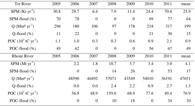
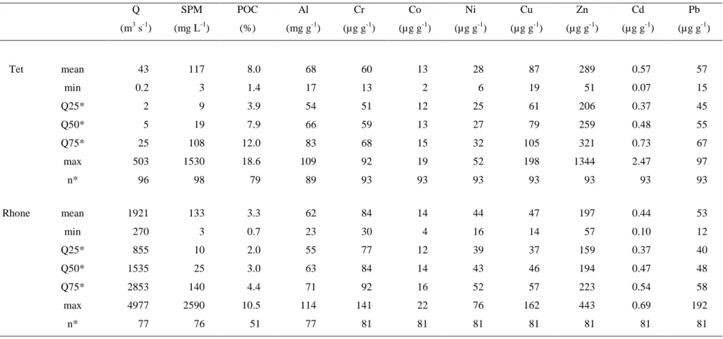
Table 3.1 SPM, water and POC discharges from the Tet and Rhone during the study period Table 3.2 Variability of PTM concentrations and associated parameters in the Tet and Rhone rivers during the study period.
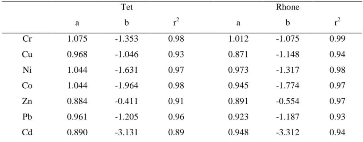
Table 3.3 Regression and correlation coefficients between PTM (in μg.L-1) and SPM (in mg.L-1) according to the general form: log(PTM) = a log(SPM) + b.
Table 3.4 Average PTM fluxes in the Tet and Rhone rivers during the study period.
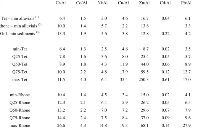
Table 3.5 Variability of Al-normalised PTM concentrations in the Tet and Rhone rivers in comparison with potential natural background levels compiled from different sources.
Table 3.6 PTM fluxes (% mean*) from the Tet and Rhone rivers during the studied floods.
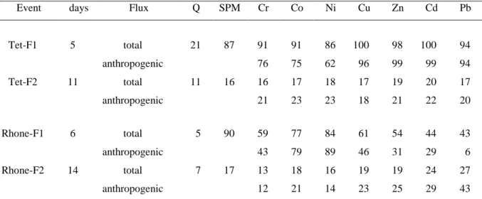
Table 4.1 TMF and SPM fluxes, POC content, grain-size parameters and particulate trace metal concentrations from the CASCADE sediment trap samples, high-frequency water sampling and sediment cores. Mean trace element concentrations are flux-weighted mean concentrations.
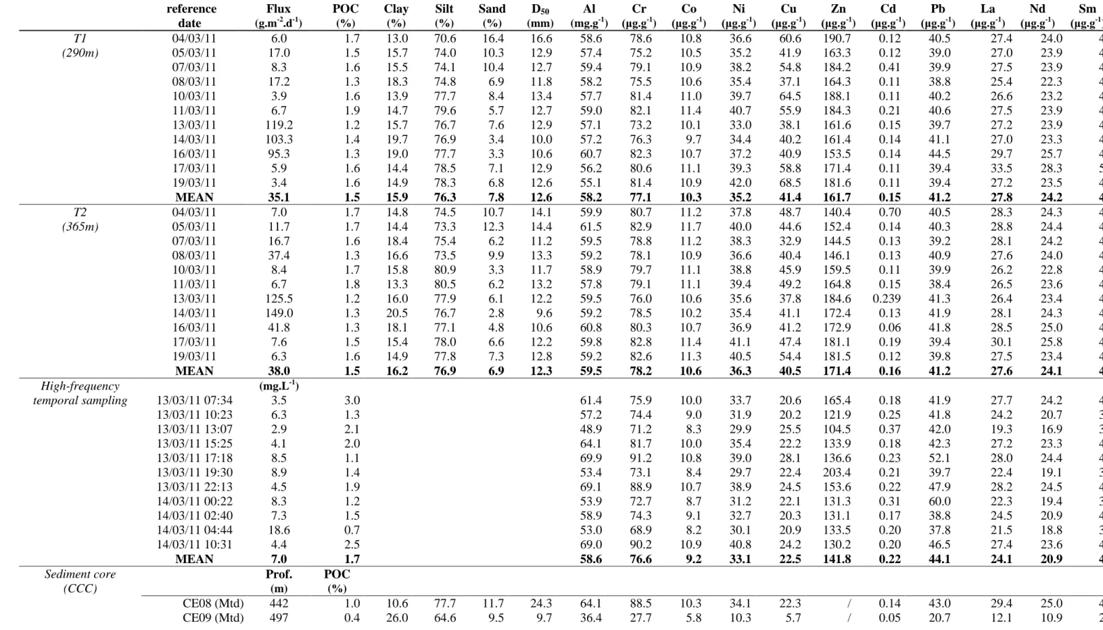
Table 4.2 Mean EFs calculated in both sediment traps samples, high-frequency water sampling samples and the first centimeter of the fresh sediment deposit recovered by multi-corer, with different references. For the local Rhone riverbank reference samples, correlation coefficients (r2) were calculated between EF and POC content (significance > 99% with 9 degrees of freedom). Those EF values are compared to EFs calculated by Roussiez et al. (2012).
Table 4.3 CASCADE mass and PTM fluxes. All fluxes are in mg.m-2.d-1 except for Cd, which is in µg.m-2.d-1. Values in brackets represent the percentage of lability (HCl-leaching) from sediment trap T1. Values in italics are the contribution of the storm (PTM fluxes and storm-induced export) to the March 2011 daily fluxes and total export. The total March 2011 export (in tons) was calculated from the estimation of sediment transport by Bourrin et al. (2012). Comparison is made with the results from Roussiez et al. (2012) who studied the flood and storm of December 2003.
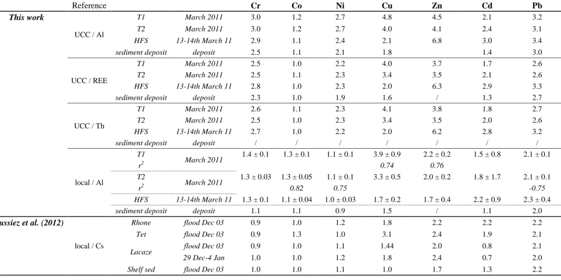
Table 4.4 HCl-extracted metal concentrations and contribution to the total, in SPM from the Rhone and Tet rivers as well as the sediment trap samples collected during the CASCADE cruise. All concentrations are expressed in μg.g-1.
after the reference date of the 15-days sampling interval.
Table 4.6 a) Pearson correlation matrices, during and pre and post DSWC conditions and b) correlation coefficients between Al-normalized concentrations and POC in CCC sediment trap samples.
Table 4.7 Mean EFs calculated in CCC sediment trap samples and standard deviation. For the local Rhone riverbank reference samples, correlation coefficients (r2) were calculated between EF and POC content (significance > 99% with 9 degrees of freedom). Those EF values are compared to EFs calculated by Dumas et al. (2014) in CCC sediment trap samples, high-frequency water sampling samples and the first centimeter of the fresh sediment deposit recovered in the CCC after the E-SE storm studied. Mean EF values calculated by Roussiez et al. (2012) in superficial shelf sediments are also shown.
Table 4.8 a) Comparison between HERMES sediment traps’ mass and trace metal fluxes. All fluxes are in mg.m-2.d-1 except for Al, which is in g.m-2.d-1 and for Cd, which is in µg.m-2.d-1. b) Comparison between CCC PTM daily fluxes and total export calculated in this work and in Dumas et al., 2014.
Table 5.1 Location and length of the deep sediment cores from the North Western Mediterranean sea investigated in this study.
Table 5.2 PTM Concentrations, grain-size distribution, Corg and carbonate contents, C:N ratios and calculated datation in deep cores.
Chapter I
Introduction
Although coastal areas represent only 18% of the worldwide ocean, they are the connexion between continent, ocean and atmosphere domains. They are the scene for production, transformation, transfer, export and storage of both natural and anthropogenic inputs. Indeed, rivers hydrology is dependent on seasonal and regional climate (snowmelt, intense rainfalls) which cause elevated discharge of freshwater and particulate matter on coastal margins, called seasonal or oceanic flood according to the size of the drainage basin (Drake & Cacchione, 1985; Mulder & Syvitski, 1996; Sommerfield & Nittrouer, 1999; Mullenbach & Nittrouer,
2000; Roussiez et al., 2005). Deposition of sediment in estuaries and river prodeltas is
ephemeral as mechanisms such as bottom nepheloid layers, winter storms and/or mesoscale circulation patterns rework the inner shelf, resuspending and redistributing this particulate load along and across-shelf to the mid-shelf and beyond (Puig & Palanques, 1998; Ogston &
Sternberg, 1999; Geyer et al., 2000).
High-energy oceanographic processes such as storms, waves and dense water formation occur on continental margins and induce currents that rapidly transfer important amounts of water, sediment particles, organic matter but also litter and chemical pollutants, from the continental shelf to the deep-ecosystems, which are very sensitive to external inputs. Coastal zones hence play a key role in marine biogeochemical cycles and primary production by providing nutrients to the open-ocean. A good understanding of the ecosystems functioning and behaviour will help anticipate their evolution, but also to identify the major threats they face, their potential impact and, ultimately, it will provide the tools required to improve the sustainable management of living (deep-sea benthic and pelagic organisms) as well as inert ressources (Canals et al., 2013). For example, particulate material is regularly removed from coastal and deep-sea regions to sand up beaches but, only recently, few studies have been carried out in the Manche area, regarding the impact of this sediment load’s extraction on the remobilization and transfer of contaminants(Lozach, 2011; Duclos, 2012).
Indeed, coastal zones are also subjected to increasing anthropogenic pressures over the years : more than 60% of the world’s population lives within 150km of the coast and uses coastal areas as a source of food (Holligan and de Boois, 1993) or leisure. Unfortunately marine pollution arises from this constant increase in population density and industrialization. Anthropogenic impacts, either direct through bottom trawling or litter and chemical pollutants release, or indirect, through global warming, do have a central part in deep-sea environment functioning (Glover et al., 2003). Indeed, repetitive droughts in summers, as well as more frequent and more violent torrential precipitations in autumns and winters could lead to modifications of hydrological regimes, then biogeochemical cycles and environments to some
extent. For example, it is known that climate change will have profound effects on the frequency, intensity and eventually the location of key oceanographic processes like Dense-Shelf Water Formation (DSWC) and eastern storms or open-ocean convection, the three tenors of the NW Mediterranean Sea (Canals et al., 2013). In order to know how those changes will also impact the role those key processes have on sustaining the deep ecosystems but also on carrying chemical pollution, one has to fully understand how those processes function nowadays.
As the development of industrial societies is linked to discovery and use of metals, their consumption has increased by 300% in the last fifty years and anthropogenic release of metallic elements such as Pb, Hg, Zn, Cd, Cu and Cr have tripled since the beginning of the industrial era (INERIS, 2006). Trace metals hence seem like a good indicator of anthropogenic pressures because it is possible to distinguish natural from man-made contribution. Most trace metals are naturally present in the continental crust in low concentrations, but additionnal inputs from anthropogenic origin are now frequent.
Some trace metals are essential, like Cu, Zn or Se; some have specific roles, like Ni in urease; but others have no biological functions and are toxic, like Cd, Hg or Pb. And even essential trace metals can be lethal in high levels or under bioavailable forms. This labile, bioavailable stock becomes exchangeable with the surrounding environment and is usually introduced by anthropogenic activities (Salomons and Forstner, 1984).
Hence, management of risks related to trace metals imply monitoring and controlling trace metal fluxes in each compartment of the ecosystem (Berthelin & Bourrelier, 1993).
As trace metal distribution in the marine environment is largely controlled by the particulate phase (Turekian, 1977), especially by fine sediment particles, due to their affinity for silt and clay (Gibbs, 1973), therefore, their fate is also linked to suspended particulate matter discharge to the sea, dispersal dynamics and ultimately, sequestration in the sedimentary strata. Those are controlled by rapid physico-chemical and hydro-meteo-climatic forcings (floods, storms, primary production…) as well as slow ones (diagenesis and climate change). In estuaries, during the passage from the freshwater to the marine environment, throughout the salinity gradient, trace metals undergo remobilization processes. For example, some are removed from the dissolved phase and taken up by particulate matter, which can be deposited then resuspended during larger estuarine mixing episodes (Duinker et al., 1978).
able to resuspend and disperse them step by step until they reach the deep environments in episodic pulses. However, very few informative and systematic studies have been conducted on contaminant concentrations and fluxes in deep-sea environments.
In this context, the Mediterranean Sea seems well fitted. With a surface of 2.5 106 km2 the Mediterranean Sea represents only 1% of the global ocean surface (Amblas et al., 2004), and due to its enclosed character and restricted exchanges with the open ocean, it is strongly influenced by continental inputs of water, sediment, nutrients and chemical pollutants, but also by coastal-pelagic interactions and hydrodynamic functioning. It is also susceptible to climate change and anthropogenic pressures, as years of intense development and exploitation have resulted in significant changes of its fragile natural resources. Coastal urbanisation, industrialisation and touristic exploitation, intensive agriculture, riverine and atmospheric inputs and fisheries are only some of the anthropogenic forcings which have exerted a progressively growing pressure on the mediterranean environment.
The Gulf of Lion (GoL) in particular (Fig.1.1) exhibits specific characteristics like small tidal currents, variable wind-driven circulation and dense-water formation. It is probably an area in the Mediterranean Sea advantaged for across-shelf export because the GoL is often affected by relatively stronger storms, dense shelf water cascading and wind-induced cyclonic circulation (Durrieu de Madron et al., 2005; Palanques et al, 2006; Canals et al., 2006;
Ogston et al., 2008). As the NW Mediterranean margins are the most densely canyoned in the
entire basin, the GoL is also a privileged area for down-shelf export. Indeed Puig et al. (2013) demonstrated how submarine canyons are preferential conduits for matter and energy transfer from the surface to the deep ecosystem. Their distribution, characteristics and functioning have a strong influence on sediment transfer and deep ecosystem functioning and they are likely to significantly contribute of the propagation of anthropogenic signals (e.g. PBDE accumulation at the end of the Cap de Creus and Lacaze-Duthiers submarine canyons,
Fig.1.1 Map of the GoL (from Durrieu de Madron et al., 2008) with moutains (Pyrenees, Massif Central and
Alps), rivers and bathymetric features (Lacaze-Duthiers and Cap de Creus submarine canyons in particular)
The GoL is hence considered as a test-zone for the long-term evolution of sediment transport and has been the place of numerous European research programs for the past 20 years. EUROpean Margin STRATA FORMation (EUROSTRATAFORM, 2002-2005) was developed to understand sedimentary processes, deposits and stratigraphy in areas of the northeast Atlantic and Mediterranean systems, representative of the European continental margin (Syvitski et al., 2004; Weaver et al., 2006). It provided the opportunity to study the effects of the DSWC (2004-05 event), extreme floods (December 2003 event on the Rhone river) and storms which are the most effective processes controlling sediment dynamics in the GoL’s continental shelf. Results and modelling emphasized the predominant role of E-SE storms in wave-induced resuspension and along-shelf cyclonic transport of fine sediment on the inner shelf but also during periods of dense water formation driven by N-NW winds. These two wind-driven processes induce most of the export of suspended sediment and associated elements from shelf, primarily at the southwestern end of the Gulf. These events displayed a clear seasonality and large interannual variability and are likely to be sensitive to climatic changes.
CDC LDC
Following this program, HERMES (Hotspot Ecosystem Research on the Margins of European Seas, 2005-2009), HERMIONE (Hotspot Ecosystem Research on Man’s Impact on European Seas, 2009-2012) and now PERSEUS (Policy-oriented marine Environmental Research in the Southern EUropean Seas, 2012-2015), were designed to deepen the current understanding of the Mediterranean marine ecosystems and their response to spatial and temporal modifications of physico-chemical forcing linked to changing environmental conditions and increasing human pressure. Those integrated approaches always considered the continuum between the coastal zone and the open sea. Such scientific data are used in the frame of the Marine Strategy Framework Directive (MSFD), a European initiative which aims at attaining good environmental status in marine waters by 2020, notably in the deep-sea ecosystem. As some of these programs are still ongoing, the scientific community recognizes the need to quantify and assess the fluxes of trace metals in our case, from the continent, which acts as a source, to the marine environments acting as a receiver. Improving our knowledge on land-to-sea transfer of sediment, organic matter (a PhD is currently conducted on this topic at the CEFREM) and bound contaminants and knowing what happens to it once it is delivered to the coastal waters is one of the priorities for a better understanding of global biogeochemical cycles (Sanchez-Vidal et al., 2013).
In the GoL, trace metals have been well studied. They were used as geochemical tools: fine sediment fraction normalizer (Roussiez et al., 2005) or geochemical tracers of atmospheric fallout pattern (Miralles et al., 2006) or lithogenic sources (Roussiez et al., 2013).
On the continental shelf, spatial and temporal studies were conducted to elucidate their fate in the sedimentological cycle (Roussiez et al., 2006, 2011; Radakovitch et al., 2008), often resulting in budget calculations. Ollivier et al. (2011) and Roussiez et al. (2012) estimated the flood contribution to annual Particulate Trace Metal (PTM) input fluxes to be between 15 and 91%, depending on the element. Radakovitch et al. (2008) showed that, between 2000 and 2003, particulate input fluxes of trace metals from the Rhone River were 2 to 10 times higher than particulate atmospheric deposition. He compared his results with estimations of dissolved and particulate metals fluxes (fromGuieu et al., 1997) deposited from various sites of the northwestern Mediterranean Sea for which he used mean flux values. Regarding atmospheric particulate deposition of trace metals, Guieu et al. (1997) highlighted the importance of dry deposition (i.e. Saharan dust). Moreover, Guieu et al. (1997) and Elbaz-Poulichet et al. (2001) showed that, concerning dissolved trace metal fluxes, atmospheric inputs represent more than 50% of the total dissolved trace metal inputs to the NW
Mediterranean Sea. In the canyon environments, Grousset et al. (1995) studied the distribution of PTMs in the Lacaze-Duthiers canyon and Roussiez et al. (2012, 2013) looked at the output fluxes in the head of the Cap de Creus canyon. In the deep-sea basin, Marin et al. (2001) studied the forcing factors controlling the distribution of Mn and Fe in sediment cores from the GoL continental shelf and deep-basin and Angelidis et al. (2011) highlighted the accumulation of anthropogenic Cd, Pb and Zn in surficial sediment of deep cores, but suspected atmospheric deposition to be the main source for trace metal inputs in this deep-basin area.
Since PTMs have been well documented in the past (Fig.1.2), the objectives of this study were not to develop a new analytical technique. We rather wanted, with the help of long-term surveys, to fill in some gaps of specific situation consequences on PTM dynamics. For example, until now, great attention was focused on the Rhone river but less was granted to small coastal rivers and their respective contribution to the annual PTM inputs.
Fig.1.2 From Roussiez et al. (2006). Spatial distribution of Cu, Cd and Ni contents in less than 63 μm sediment
In this way, we also aimed at proposing a sampling strategy for PTM export budgets calculation, through the example of the Tet and Rhone rivers.
Those methods might ease potential decision in sustainable management decisions for the future of the coastal zones. Also, the sedimentological cycle of PTM was extensively studied on the continental shelf (from prodeltas to mid and outer shelf) but less studies were conducted on PTM transport processes and fate in submarine canyons and beyond. Objectives of this study are first to quantify the fluxes transferred and deposited from the continental shelf to the deep basin. Since this export mostly takes place under extreme hydro-meteo-dynamic processes, we focused on floods, E-SE storm and DSWC case studies. Input fluxes by rivers, which happen mainly during flood events, and output fluxes due to hydrodynamic processes will help us in assessing the role of continental shelf as a source or sink of trace metal and its flushing potential from the shelf toward deep environments.
We also aim at characterizing the origin of those PTM, through the study of specific Rare Earth Elements and of their natural and residual fraction but also to evaluate the anthropogenic part of those fluxes and its potentially bioavailable nature. Through those spatial and temporal resolution studies of heavy metal downward fluxes from the GoL coastal rivers and in the southwesternmost canyons, we will help understand the input, transfer and deposition fluxes of heavy metals from the GoL continental area to deeper environments. The manuscript is organized in the following manner :
The second chapter will present in more detail the study area, the samples and sampling strategies used in this work as well as the analytical and calculation methods.
In order to follow the general land-to-sea continuum reasoning, we will first present the results of our study on riverine inputs in the third chapter. The results from this chapter were obtained after a 5-year monitoring of the GoL coastal rivers, which makes it the most up-to-date dataset in the GoL coastal system regarding metallic contaminants. Particular attention was paid to flood events and their respective contribution to the annual riverine input.
The fourth chapter will deal with transfer processes through submarine canyons : transfer triggered by E-SE storm in the first part and by DSWC in the second part. We will also quantify their relative output contribution of PTM compared to annual riverine input in order to assess and compare both event-related export and depurating potential.
In the fifth chapter, we will focus on the deep basin through analysis of the trace metal contents of three deep sediment cores which are the result of previously described transport and input.
References
Amblas, D., Canals, M., Lastras, G., Berne, S., Loubrieu, B. (2004). Imaging the seascapes of the Mediterranean. Oceanography, 17 (4), 144–155.
Angelidis, M.O., Radakovitch, O., Veron, A., Aloupi, M., Heussner, S., Price, B. (2011). Anthropogenic metal contamination and sapropel imprints in deep Mediterranean sediments.
Marine Pollution Bulletin, 62, 1041-1052.
Berthelin, J., Bourrelier, P.H. (1998). Contamination des sols par les éléments en traces : les risques et leur gestion. Académie des Sciences, Tec et doc (éd.), rapport n°42.
Canals, M., Puig, P., Durrieu de Madron, X., Heussner, S., Estournel, C. (2006). Flushing submarine canyons. Nature, 444, 354-357.
Canals, M., Company, J.B., Martín, D., Sànchez-Vidal, A., Ramírez-Llodrà, E. (2013). Integrated study of Mediterranean deep canyons: Novel results and future challenges.
Progress in Oceanography, 118, 1-27.
Drake, D.E., Cacchione, D.A. (1985). Seasonal variation in sediment transport on the Russian River shelf, California. Continental Shelf Research, 4, 495-514.
Duclos, P.A. (2012). Impacts morpho-sédimentaires de l’extraction de granulats marins. Application au bassin oriental de la Manche. Université de Rouen, 286 p.
Durrieu de Madron, X., Zervakis, V., Theocharis, A., Georgopoulos, D. (2005). Comments on “Cascades of dense water around the world ocean”, Progress in Oceanography, 64(1), 83-90.
Elbaz-Poulichet, F., Guieu, C., Morley, N.H. (2001). A Reassessment of Trace Metal Budgets in the Western Mediterranean Sea. Marine Pollution Bulletin, 42(8), 623-627.
Geyer, W.R., Hill, P., Milligan, T., Traykovski, P. (2000). The structure of the Eel River plume during floods. Continental Shelf Research, 20, 2067-2093
Gibbs, R.J. (1973). Mechanisms of trace metal transport in rivers. Science, 180, 71-72.
Glover, A.G., Smith, C.R. (2003). The deep-sea floor ecosystem: current status and
prospects of anthropogenic change by the year 2025. Environmental Conservation, 30, 219– 241.
Grousset, F.E., Quetel, C.R., Thomas, B., Donard, O.F.X., Lambert, C.E., Guillard, F., Monaco, A. (1995). Anthropogenic vs. lithogenic origins of trace elements (As, Cd, Pb, Rb, Sb, Sc, Sn, Zn) in water column particles: northwestern Mediterranean Sea. Marine
Chemistry, 48(3–4), 291-310.
Guieu, C., Chester, R., Nimmo, M., Martin, J.M., Guerzoni, S., Nicolas, E., Mateu, J., Keyse, S. (1997). Atmospheric input of dissolved and particulate metals to the northwestern Mediterranean. Deep Sea Research Part II: Topical Studies in Oceanography, 44(3–4), 655-674.
Holligan, P.M., de Boois, H.E. (1993). The LOICZ Science Plan. IGBP Report n°25. Stockholm, IGBP : 50 p.
INERIS, (2006). Recommandations pour la modélisation des transferts des éléments traces métalliques dans les sols et les eaux souterraines. Rapport d’étude
N°INERIS-DRC-06-66246/DESP-R01a.
Lozach, S. (2011). Habitats benthiques marins du bassin oriental de la Manche : enjeux écologiques dans le contexte d’extraction de granulats marins. Université de Lille Nord de France, 308 p.
Marin, B., Giresse, P. (2001). Particulate manganese and iron in recent sediments of the Gulf of Lions continental margin (north-western Mediterranean Sea): deposition and diagenetic process. Marine Geology, 172(1–2), 147-165.
Miralles, J., Veron, A., Radakovitch, O., Deschamps, P., Tremblay, P., Hamelin, B. (2006). Atmospheric lead fallout over the last century recorded in Gulf of Lions sediments (Mediterranean Sea). Marine Pollution Bulletin, 52 (11), 1364-1371.
Mullenbach, B.L., Nittrouer, C.A. (2000). Rapid deposition of fluvial sediment in the Eel Canyon, northern California. Continental Shelf Research, 20(16), 2191-2212.
Ogston, A.S. and Sternberg, R.W., (1999). Sediment transport events on the northern California continental shelf. Marine Geology, 154, 69-82.
Ogston, A., Drexler, T., Puig, P. (2008). Sediment delivery, resuspension, and transport in two contrasting canyon environments in the southwest Gulf of Lions. Continental Shelf
Research, 28(15), 2000-2016.
Ollivier, P., Radakovitch, O., Hamelin, B. (2011). Major and trace element partition and fluxes in the Rhône River. Chemical Geology, 285(1–4), 15-31.
Palanques, A., Durrieu de Madron, X., Puig, P., Fabres, J., Guillén, J., Calafat, A., Canals, M., Heussner, S., Bonnin, J. (2006). Suspended sediment fluxes and transport processes in the Gulf of Lions submarine canyons. The role of storms and dense water cascading. Marine
Geology, 234, 43-61.
Puig, P., Palanques, A. (1998). Nepheloid structure and hydrographic control on the Barcelona continental margin, northwestern Mediterranean. Marine Geology, 149(1-4), 39-54.
Puig, P., Palanques, A., Sanchez-Cabeza, J.A., Masqué, P. (1999). Heavy metals in particulate matter and sediments in the southern Barcelona sedimentation system (North-Western Mediterranean). Marine Chemistry, 63, 311-329.
Puig, P., Palanques, A., Martin, J. (2014). Contemporary Sediment-Transport Processes in Submarine Canyons. Annual Review of Marine Science, 6(5), 53-77.
Radakovitch, O., Roussiez, V., Ollivier, P., Ludwig, W., Grenz, C., Probst, J.L. (2008). Input of particulate heavy metals from rivers and associated sedimentary deposits on the Gulf of Lion continental shelf. Estuarine, Coastal and Shelf Science, 77, 285-295.
Roussiez, V., Ludwig, W., Probst, J.L., Monaco, A. (2005). Background levels of heavy metals in surficial sediments of the Gulf of Lions (NW Mediterranean): an approach based on 133
Cs normalization and lead isotope measurements. Environmental Pollution, 138, 167-177.
Roussiez, V., Ludwig, W., Probst, J.L., Monaco, A., Bouloubassi, I., Buscail, R., Saragoni, G. (2006). Sources and sinks of sediment-bound contaminant in the Gulf of Lions (NW Mediterranean Sea): a multi-tracer approach. Continental Shelf Research, 26, 1843-1857. Roussiez, V., Ludwig, W., Radakovitch, O., Probst, J.-L., Monaco, A., Charrière, B., Buscail, R. (2011). Fate of metals in coastal sediments of a Mediterranean flood-dominated system: An approach based on total and labile fractions. Estuarine, Coastal and Shelf Science, 92(3), 486-495.
Roussiez, V., Heussner, S., Ludwig, W., Radakovitch, O., Durrieu de Madron, X., Guieu, C., Probst, J.-L., Monaco, A., Delsaut, N. (2012). Impact of oceanic floods on particulate metal inputs to coastal and deep-sea environments: A case study in the NW Mediterranean Sea.
Continental Shelf Research, 45, 15-26.
Roussiez, V., Aubert, D., Heussner, S. (2013). Continental sources of particles escaping the Gulf of Lion evidenced by rare earth elements: flood vs. normal conditions. Marine
Chemistry, 153, 31-38.
Salomons, W., & Förstner, U. (1984). Metals in the hydrocycle. Berlin-Heidelberg-New York-Tokyo : Springer-Verlag, 349 p.
Salvadó, J.A., Grimalt, J.O., López, J.F., Durrieu de Madron, X., Heussner, S., Canals, M. (2012). Transformation of PBDE mixtures during sediment transport and resuspension in marine environments (Gulf of Lion, NW Mediterranean Sea). Environmental Pollution, 168, 87-95.
Sanchez-Vidal, A., Higueras, M., Martí, E., Liquete, C., Calafat, A., Kerhervé, P., Canals, M. (2013). Riverine transport of terrestrial organic matter to the North Catalan margin, NW Mediterranean Sea. Progress in Oceanography, 118, 71-80.
Sommerfield, C.K., Nittrouer, C.A. (1999). Modern accumulation rates and a sediment budget for the Eel shelf: a flood-dominated depositional environment. Marine Geology, 154(1–4), 227-241.
Syvitski, J.P., Peckham, S.D., Hilberman, R., Mulder, T. (2003). Predicting the terrestrial flux of sediment to the global ocean: a planetary perspective. Sedimentary Geology, 162(1–2), 5-24.
Turekian, K.K. (1977). The fate of metals in the oceans. Geochimica et Cosmochimica Acta, 41(8), 1139-1144.
Weaver, P.P.E., Canals, M., Trincardi, F. (2006). EUROSTRATAFORM Special Issue of
Chapitre I
Introduction
Bien que les zones côtières ne représentent que 18 % de l'océan mondial, elles sont l’interface entre continent, océan et atmosphère. Elles sont le lieu de production, de transformation et de transfert de matière mais aussi des zones d'export et de stockage des apports naturels et anthropiques. En effet, le climat régional et une forte saisonnalité des régimes (fonte des neiges, pluies abondantes) influencent l’hydrologie des rivières et peuvent provoquer des élévations de débits significatives et par conséquent des apports en matières en suspension élevés sur les marges côtières. Ces hausses de débits sont alors appelées inondations saisonnières ou océaniques en fonction de la taille du bassin versant correspondant (Drake & Cacchione, 1985; Mulder & Syvitski, 1996; Sommerfield & Nittrouer, 1999; Mullenbach &
Nittrouer, 2000; Roussiez et al., 2005). Le dépôt de ces sédiments dans les estuaires et
prodeltas des rivières est éphémère car des mécanismes tels que les couches néphéloïdes de fond, les tempêtes hivernales et/ou la circulation générale « retravaillent » le plateau, provoquant la remise en suspension et la redistribution de ces dépôt de particules à travers et le long du plateau continental et au-delà vers la pente (Puig et Palanques, 1998; Ogston &
Sternberg, 1999; Geyer et al., 2000).
Les processus océanographiques intenses tels que les tempêtes, les vagues et la formation d'eau dense se produisent sur les marges continentales et induisent des courants qui transfèrent rapidement d’importantes quantités d'eau, de sédiments, de matière organique, mais aussi de déchets et de contaminants chimiques, du plateau continental vers les écosystèmes profonds, eux-mêmes très sensibles aux apports externes. Les zones côtières jouent donc un rôle clef dans les cycles biogéochimiques marins et la production primaire en fournissant notamment, par les processus cités ci-dessus, des nutriments essentiels à l’océan ouvert. Une bonne compréhension du fonctionnement des écosystèmes et de leur comportement contribue à anticiper leur évolution, mais aussi à identifier les principales menaces auxquelles ils sont confrontés, leurs impacts potentiels et, en fin de compte, fournit les outils nécessaires à l’amélioration de la gestion durable des ressources vivantes (organismes benthiques et pélagiques de fond) ainsi que des ressources inertes (Canals et al., 2013). Par exemple, des stocks sableux sont régulièrement extraits des régions côtières et du large afin de ré-ensabler le littoral. Jusqu’à récemment, peu d’études ont été menés sur l’impact de l’extraction de ce stock sédimentaire, sur la remobilisation de particules fines protégées par le drapage sableux ou sur les conséquences de ce transfert sédimentaire en terme d’apport potentiel en contaminants à la zone littorale (Lozach, 2011; Duclos, 2012).
Les zones côtières ont été soumises à des pressions anthropiques croissantes au fil des ans : actuellement plus de 60% de la population mondiale vit à moins de 150 km de la côte et utilise les zones littorales en tant que zones de production de ressources alimentaires
(Holligan et de Boois, 1993) ou de loisirs. Malheureusement la pollution marine provient de
l'augmentation constante de cette densité de la population et de l'industrialisation de ces zones. Les impacts anthropiques, soit directs par le chalutage de fond ou par le relargage de déchets et de polluants chimiques, ou indirects, de par le réchauffement climatique par exemple, ont un rôle central dans le fonctionnement des environnements profonds (Glover et
al., 2003). Par exemple, les sécheresses répétitives en période estivale, ainsi que les
précipitations torrentielles plus fréquentes et plus violentes en automne et en hiver pourraient conduire à des modifications des régimes hydrologiques, et par la même des cycles biogéochimiques et des environnements dans leur ensemble. Ainsi, il est connu que le changement climatique peut avoir des effets importants sur la fréquence, l'intensité et éventuellement l'emplacement des processus océanographiques clefs comme la formation d’eaux denses côtières (cascading) et les tempêtes d’Est ou la convection, les trois ténors de la Méditerranée Nord-Occidentale (Canals et al., 2013). Il est donc nécessaire de comprendre le fonctionnement actuel de ces processus afin de comprendre l’influence d’éventuels futurs changements sur le maintien des écosystèmes profonds, mais également sur le transport de la pollution chimique.
Le développement des sociétés industrielles étant lié à la découverte et à l'utilisation des métaux, leur consommation a augmenté de 300% au cours des cinquante dernières années et les rejets anthropiques d'éléments métalliques tels que Pb, Hg, Zn, Cd, Cu et Cr ont triplé depuis le début de l'ère industrielle (INERIS, 2006). Les métaux traces semblent donc être un bon indicateur des pressions anthropiques, car il est possible de distinguer la contribution naturelle de celle due à l'homme. En effet, la plupart des métaux traces sont naturellement présents dans la croûte continentale en faibles concentrations, mais des apports additionnels d'origine anthropique sont maintenant fréquents.
Certains métaux sont essentiels, comme Cu, Zn ou Se; certains ont des rôles spécifiques, comme Ni avec l’uréase; mais d'autres n'ont pas de fonctions biologiques et sont toxiques, comme Cd, Hg ou Pb. Il en est de même pour les métaux traces essentiels qui peuvent être mortels à fortes doses ou sous des formes biodisponibles. Ce stock de métaux labiles et potentiellement biodisponibles peut être échangé avec le milieu environnant et est généralement introduit par les activités anthropiques (Salomons et Forstner, 1984).
Par conséquent, la gestion des risques liés aux métaux traces implique de surveiller et de contrôler leurs flux dans chaque compartiment de l'écosystème (Berthelin et Bourrelier, 1993). Comme la distribution des métaux traces dans l'environnement marin est en grande partie contrôlée par la phase particulaire (Turekian, 1977), en particulier par les particules fines, en raison de l’affinité des ces métaux avec les silts et les argiles (Gibbs, 1973), leur sort est également lié aux particules en suspension rejetées en mer, à leur dynamique de dispersion et, finalement, à leur séquestration dans les couches sédimentaires. Tous ces paramètres sont contrôlés par les forçages physico-chimiques et hydro-météo-climatiques rapides et intenses (crues, tempêtes, production primaire, ...) mais aussi par des forçages plus lents (diagenèse et changement climatique). En effet, les contaminants liés aux sédiments dépendent du régime hydrologiques des rivières et de leurs événements épisodiques de rejet, et de la force et de la durée des processus de mélange et d’advection qui seront en mesure de les remettre en suspension et de les disperser sporadiquement, de proche en proche, jusqu'à ce qu'ils atteignent les environnements profonds. Cependant, très peu d'études systématiques ont été menées à ce jour sur les concentrations et les flux de contaminants dans les environnements profonds.
Dans ce contexte, la Méditerranée un lieu d’étude privilégié. Avec une surface de 2,5.106 km2, elle ne représente que 1% de la surface de l'océan mondial (Amblas et al., 2004), et en raison de son caractère fermé et des échanges restreints avec l'océan ouvert, elle est fortement influencée par les apports continentaux en eau, en sédiments, en nutriments et en contaminants chimiques, mais aussi par les interactions côtières-pélagiques et le fonctionnement hydrodynamique global. Elle est également sensible au changement climatique et aux pressions anthropiques, car des années de développement intense et d'exploitation ont entraîné des modifications importantes de ses ressources naturelles fragiles. L'urbanisation du littoral, l'industrialisation et l'exploitation touristique, l'agriculture intensive, la fluctuation des apports fluviaux et atmosphériques et la pêche sont une partie seulement des forçages anthropiques qui ont exercé une pression progressivement croissante sur l'environnement méditerranéen.
Le Golfe du Lion (GdL) en particulier (Fig.1.1) présente des caractéristiques spécifiques comme un faible marnage, une circulation soumise aux vents et est une zone de formation d'eaux denses. C'est probablement une zone privilégiée de la mer Méditerranée pour l'export du plateau continental, car le GdL est souvent affecté par des tempêtes relativement fortes, des cascades d'eaux denses et par une circulation cyclonique induites par les vents (Durrieu
de Madron et al., 2005; Palanques et al., 2006; Canals et al., 2006; Ogston et al., 2008). Comme les marges méditerranéennes nord-occidentales sont les plus densément entaillées par des canyons, le GdL est également un lieu privilégié pour les processus d’export hors du plateau. En effet Puig et al. (2013) ont démontré que les canyons sous-marins sont des conduits préférentiels pour le transfert de matière et d'énergie de la surface vers l'écosystème profond. Leurs répartitions, leurs caractéristiques et leurs fonctionnement ont une forte influence sur ce transfert de sédiments et sur le fonctionnement des écosystèmes profonds puisqu’ils sont susceptibles de contribuer de manière significative à la propagation des signaux anthropiques (exemple de l'accumulation de PBDE au bas des canyons sous-marins du Cap de Creus et Lacaze-Duthiers, Salvadó et al., 2012).
Fig.1.1 Carte du GdL (de Durrieu de Madron et al., 2008). Les massifs montagneux (Pyrénées, Massif Central et
Alpes), les principaux fleuves, les caractéristiques bathymétriques (canyons sous-marins Lacaze-Duthiers (LDC) et Cap de Creus (CDC), en particulier) ainsi que les régimes de vents dominants sont représentés
Le GdL est donc considéré comme une zone-test de l'évolution à long terme du transport sédimentaire et a été le lieu de nombreux programmes de recherche européens ces 20 dernières années. EUROpean marge STRATA formation (EUROSTRATAFORM, 2002-2005) a été développé pour comprendre les processus sédimentaires, de déposition et
CDC LDC
stratigraphiques dans les systèmes Atlantique-Nord et méditerranéens, représentants de la marge continentale européenne (Syvitski et al., 2004; Weaver et al., 2006). Ce programme a permis d'étudier les effets du cascading (événement de l’hiver 2004-05), des crues extrêmes (événement de Décembre 2003 sur le Rhône) et des tempêtes, considérés comme les procédés de contrôle de la dynamique sédimentaire les plus efficaces sur le plateau continental du GdL. Ces résultats et la modélisation ont souligné le rôle prépondérant des tempêtes E-SE dans la remise en suspension induites par leurs vagues et le transport cyclonique des sédiments fins le long du plateau interne mais aussi pendant les périodes de formation d'eaux denses induites par les vents de N-NO. Ces deux processus dus au vent induisent la majeure partie de l'export de particules en suspension et d’éléments associés hors du plateau, principalement à l'extrémité sud-ouest du golfe. Ces événements ont montré une saisonnalité claire et une grande variabilité interannuelle qui sont susceptibles d'être modifiées suite aux changements climatiques.
Après ce programme, HERMES (Hotspot Ecosystem Research on the Margins European Seas, 2005-2009), HERMIONE (Hotspot Ecosystem Research on Man’s Impact on European Seas, 2009-2012) et maintenant PERSEUS (Policy-oriented marine Environmental Research in the Southern European Seas, 2012-2015), ont été conçus pour approfondir la compréhension actuelle des écosystèmes marins méditerranéens et leur réponse face aux modifications spatiales et temporelles des forçages physico-chimiques liés à l'évolution des conditions environnementales et à l'augmentation de la pression humaine. Ces approches intégrées ont toujours considéré le continuum entre la zone côtière et l’océan ouvert. De telles données scientifiques sont utilisées dans le cadre de la Directive-Cadre Stratégique sur le Milieu Marin (DCSMM), une initiative européenne qui vise à atteindre un bon état écologique dans les eaux marines d'ici à 2020, notamment des écosystèmes profonds.
Comme certains de ces programmes sont encore en cours, la communauté scientifique reconnaît la nécessité de quantifier et d'évaluer les flux, de métaux traces dans notre cas, du continent, qui agit comme une source, vers le milieu marin agissant comme un puits. Améliorer les connaissances sur le transfert terre-mer de sédiments, de matière organique (une thèse est actuellement menée sur ce sujet au CEFREM) et de contaminants associés et comprendre leur devenir lors de leur arrivée dans les eaux côtières et leur transfert plus au large est l'une des priorités pour une meilleure compréhension des cycles biogéochimiques globaux (Sanchez- Vidal et al., 2013).
Dans le GdL, la problématique des éléments trace métalliques a déjà été largement abordée. Ils ont été utilisés comme des outils géochimiques : afin de normaliser la fraction fine des sédiments (Roussiez et al., 2005) ou comme traceurs géochimiques des retombées atmosphériques (Miralles et al., 2006) et des sources lithogènes (Roussiez et al., 2013). Sur le plateau continental, des études spatiales et temporelles ont été menées pour déterminer leur comportement dans le cycle sédimentaire (Roussiez et al., 2006, 2011; Radakovitch et al., 2008), donnant lieu à des calculs de bilans. Ollivier et al. (2011) et Roussiez et al. (2012) ont estimé à 15 à 91 % (en fonction de l'élément) la contribution des crues à l'apport annuel de métaux traces particulaires (MTP). Radakovitch et al. (2008) ont montré que, entre 2000 et 2003, les flux d'entrée de MTP du Rhône étaient de 2 à 10 fois plus élevés que le dépôt atmosphérique particulaire. Ils se sont servis des estimations de flux métalliques dissous et particulaires (faites par Guieu et al., 1997) déposés en divers endroits de la méditerranée nord-occidentale, et pour lesquelles ils ont pris les valeurs moyennes de flux. En ce qui concerne le dépôt atmosphérique de MTP, Guieu et al. (1997) ont souligné l'importance du dépôt sec et en particulier des poussières sahariennes. En outre, Guieu et al. (1997) et Elbaz-Poulichet et al. (2001) ont montré que, concernant les flux de métaux traces dissous, les apports atmosphériques représentent plus de 50% des apports totaux de MTP dissous en mer Méditerranée Nord-Occidentale. Dans les canyons, Grousset et al. (1995) ont étudié la distribution des MTP dans le canyon Lacaze-Duthiers et Roussiez et al. (2012, 2013) ont étudié les flux exportés en tête de canyon du Cap de Creus. Marin et al. (2001) se sont focalisés sur les forçages qui contrôlent la distribution de Mn et Fe dans les carottes de sédiments du plateau continental du GdL et de son bassin profond. Dans ce dernier Angelidis et al. (2011) ont mis en évidence l'accumulation de Cd, Pb et Zn d’origine anthropique dans les sédiments de surface de carottes profondes, en suspectant la déposition atmosphérique d’être la source principale dans le bassin profond.
Puisque les MTP ont été bien documentés par le passé (Fig.1.2), les objectifs de ce travail n’étaient pas de développer de nouvelles techniques analytiques. Il s’agissait plutôt, grâce au suivi à long terme, de combler certaines lacunes sur la conséquence de situations particulières sur la dynamique des MTP. Par exemple, jusqu’à présent, une grande attention a été accordée au Rhône mais moins aux petits fleuves côtiers et à leurs contributions respectives aux apports annuels de MTP sur le plateau continental. Ainsi, nous avons également cherché à proposer une méthode d’échantillonnage pour le calcul de flux de MTP exportés, grâce à l’exemple de la Têt et du Rhône. Ces méthodes permettront peut-être de faciliter de
Fig.1.2 Tirée de Roussiez et al. (2006). La distribution spatiale des concentrations en Cu, Cd et Ni contenues
dans la fraction < à 63 μm des sédiments du plateau continental du GdL.
En outre, le cycle sédimentaire des MTP a été largement étudié sur le plateau continental (des pro-deltas au plateau intermédiaire et externe), mais moins d'études ont été menées sur les processus de transport des MTP et sur leur devenir, dans les canyons sous-marins et au-delà. Les objectifs de cette étude étaient donc aussi destinés à quantifier les flux transférés, et déposés, du plateau continental vers le bassin profond. Puisque cette exportation se déroule principalement lors de processus hydro-météo-dynamiques extrêmes, nous nous sommes particulièrement intéressés aux crues, aux tempêtes d’E-SE et au cascading. Les flux exportés par les rivières, qui se déroulent majoritairement pendant les événements de crues, et les flux exportés par ces processus hydrodynamiques nous aideront à évaluer le rôle du plateau continental en tant que source ou puit de métaux traces, et le potentiel d’épuration côtière de ces processus.
Nous visons également à caractériser l'origine de ces MTP, par l’étude spécifique des terres rares et des fractions résiduelles et naturelles, mais aussi à évaluer la part anthropique de leurs flux et leurs caractères potentiellement biodisponibles. Grâce à ces investigations à haute résolution spatiale et temporelle des flux de métaux traces exportés, cette synthèse aidera à la compréhension des mécanismes d’apports, de transfert et de dépôts des métaux traces particulaires, de la zone continentale du GdL vers les environnements plus profonds.
Le manuscrit s’organise de la manière suivante :
Le deuxième chapitre présente plus en détail la zone d'étude, les échantillons et les stratégies d'échantillonnage utilisées dans ce travail ainsi que les méthodes d'analyses et de calculs. Afin de suivre le raisonnement général d’un continuum terre-mer, nous allons d'abord présenter les résultats de notre étude sur les apports fluviaux dans le troisième chapitre. Les résultats de ce chapitre ont été obtenus après un suivi de 5 ans des rivières côtières du GdL, ce qui en fait la base de données la plus à jour dans le GdL sur les contaminants métalliques en milieu côtier. Une attention particulière a été accordée aux événements de crues et à leurs contributions respectives aux apports fluviaux annuels sur le Rhône et la Têt (pris comme un exemple caractéristique des autres fleuves côtiers).
Le quatrième chapitre portera sur les processus de transfert à travers les canyons sous-marins : transfert déclenché par les tempêtes E-SE dans la première partie et par le cascading dans la deuxième partie. Nous quantifierons également leurs contributions relatives à l’export de MTP par rapport aux apports fluviaux annuels afin d'évaluer et de comparer les deux événements en termes d’export et de potentiel d’épuration côtière.
Dans le cinquième chapitre, nous nous concentrerons sur le bassin profond grâce à l'analyse des concentrations en métaux traces de trois carottes profondes, la résultante du transport et des apports décrits précédemment.
Enfin, le sixième chapitre présentera les conclusions générales et les perspectives de cette étude.
Chapter II
1. Study area
1.1 Geomorphological characteristics of The Gulf of Lion
The Gulf of Lion (GoL) is a crescent-shaped passive margin located in the northwestern Mediterranean sea. It is extending from the Cap de Creus of northern Spain to the Cap Croisette of eastern France. At those promontories, the GoL (GoL) continental shelf almost vanishes: at the west end, near the cap de Creus canyon, it narrows to less than 2km. Its slope is indented by a dozen submarine canyons, coalescing into two major channels and extending down to the deep basin (2000 m). The most important of those canyons, in terms of both export of water and particles, is the Cap de Creus canyon at the southwestern limit of the Gulf (see Monaco et al., 1990; Raimbault and Durrieu de Madron, 2003; Canals et al.,
2006; Durrieu de Madron et al., 2008 and references therein).
This export is mainly fed by riverine inputs. Indeed, the continental shelf is fed by the Rhone river on one hand : with a drainage basin of 97,800 km2 it is the largest river in the Mediterranean in terms of water and solid discharge as it releases a mean of 10.106 T.yr-1
(Durrieu de Madron et al., 2000; Roussiez et al., 2012). It is thus the main source of
freshwater (90%) and suspended sediment to the GoL continental margin (Bourrin and
Durrieu de Madron, 2006 ). On the other hand the smaller southwestern rivers Herault, Orb,
Aude and Tet, subjected to a Mediterranean regime of intense flash-floods, are also providers of freshwater and particulate matter during those events (Serrat et al., 2001). Sediment transport processes on the shelf are controlled by the Rhone River sediment source but also by the morphology of the shelf and its circulation patterns (Ludwig et al., 2003; Drexler and
Nittrouer, 2008). Indeed fine sediments delivered to the continental shelf are temporarily
stored off river mouths, until advected and redistributed by the action of storms (Guillen et
al., 2006) and anticlockwise current that flows along the continental shelf called
Liguro-provencal-Catalan or Northern Current (Millot, 1990).
1.2 Hydrological and Hydrodynamical processes
Predominant meteorological regimes induce intense hydrodynamical events such as floods, marine storms, downwelling and dense water formation, which steer the sediment inputs, resuspension and transport on the shelf (Guillen et al., 2006; Palanques et al., 2006; Bonnin
et al., 2008; Bourrin et al., 2008; Durrieu de Madron et al., 2008; Palanques et al., 2008;
Ulses et al., 2008a and b).
As stated previously, terrigeneous material and sediment-bound contaminants inputs in the GoL are largely controlled by the intensity and frequency of the Rhone and smaller coastal rivers’ flood events. Indeed, the annual mean water discharge of the Rhone river, measured at the Beaucaire gauging station, is around 1700 m3.s-1 (Ibanez et al., 1997; Arnau et al., 2004). Discharges of 5000 m3.s-1 are regularly recorded in spring and autumn due to flood events
(Estournel et al., 1997). These last few years, the highest peak discharge was recorded in
December 2003 with 11,000 m3.s-1 (Antonelli et al, 2007). Based on historical discharge river data, such extreme floods (discharge > 10,000 m3.s-1) have an expected return period of 100 years. However, four occurred in the past 20 years: in autumns of 1993, 1994, 2002, and 2003 (Estournel et al., 1997; Maillet et al., 2006).
Although freshwater and sediment inputs to the GoL originate mainly from the Rhone River, the smaller southwestern coastal rivers Herault, Orb, Aude, Agly, Tech and Tet, subjected to a mediterranean regime of intense flash-floods, may occasionally deliver substantial amounts of freshwater and SPM. Those coastal rivers have a strong dynamicity due to their quick answer to climatic variations and have episodic discharges that are difficult to quantify
(Certain et al., 2005). Consequently, little is known about their role and importance in water
and sediment inputs to the GoL.
In this study, the Tet River was chosen as a model for small coastal rivers. In autumn, after long periods of dryness induced by the Mediterranean climate, short but strong marine winds trigger intense rainfalls that lead to flood events of the small coastal rivers like the Tet River. Although the mean liquid discharge measured at the Perpignan gauging station is 6.3 m3.s-1 (2006-2011), during one of those extreme events instantaneous liquid discharge can reach up to 1800 m3.s-1 (Serrat et al., 2001). However smaller, those flash flood events are not negligible as Serrat et al. (2001) showed that between 1980 and 1999, 78% of the total sediment flux in the Tet River occurred in 0.7% of the total time (50 days).
After its deposition off those river mouths, sediment is exported along and across-shelf by wind-induced currents, that transport sediments towards the southwestern shelf (Durrieu de
Madron et al., 2008). Indeed, the GoL is subjected to severe winter meteorological conditions
were long-lasting cold and dry winds cool and evaporate surface shelf water inducing downslope sinking of surface water masses, which are channelized in submarine canyons.