HAL Id: hal-01836323
https://hal.univ-lorraine.fr/hal-01836323
Submitted on 12 Jul 2018
HAL is a multi-disciplinary open access archive for the deposit and dissemination of sci-entific research documents, whether they are pub-lished or not. The documents may come from teaching and research institutions in France or abroad, or from public or private research centers.
L’archive ouverte pluridisciplinaire HAL, est destinée au dépôt et à la diffusion de documents scientifiques de niveau recherche, publiés ou non, émanant des établissements d’enseignement et de recherche français ou étrangers, des laboratoires publics ou privés.
Elaboration of the assessment method of the
conservation status of the habitat of community interest
”Coastal dunes with Juniperus spp.” (2250)
Maud Antoine
To cite this version:
Maud Antoine. Elaboration of the assessment method of the conservation status of the habitat of community interest ”Coastal dunes with Juniperus spp.” (2250). Sciences de l’environnement. 2014. �hal-01836323�
AVERTISSEMENT
Ce document est le fruit d'un long travail approuvé par le jury de
soutenance et mis à disposition de l'ensemble de la
communauté universitaire élargie.
Il est soumis à la propriété intellectuelle de l'auteur. Ceci
implique une obligation de citation et de référencement lors de
l’utilisation de ce document.
D'autre part, toute contrefaçon, plagiat, reproduction illicite
encourt une poursuite pénale.
Contact : [email protected]
LIENS
Code de la Propriété Intellectuelle. articles L 122. 4
Code de la Propriété Intellectuelle. articles L 335.2- L 335.10
http://www.cfcopies.com/V2/leg/leg_droi.php
2013-2014
MASTER FAGE
MASTER FAGE
MASTER FAGE
MASTER FAGE
Biologie et Ecologie pour la Forêt,
Biologie et Ecologie pour la Forêt,
Biologie et Ecologie pour la Forêt,
Biologie et Ecologie pour la Forêt,
l’Agronomie et
l’Agronomie et
l’Agronomie et
l’Agronomie et l’Environnement
l’Environnement
l’Environnement
l’Environnement
Spécialité FEN
ELABORATION OF THE ASSESSMENT METHOD OF THE
CONSERVATION STATUS OF THE HABITAT OF COMMUNITY INTEREST
"COASTAL DUNES WITH JUNIPERUS SPP. " (2250)
Maud ANTOINE
Internship supervisor : Mlle Lucie LABBE, chargée de mission Natura 2000, SMCG University tutor : M. Daniel EPRON, enseignant chercheur, Inra
Host Organization: Syndicat mixte pour la protection et la gestion de la Camargue Gardoise Centre du Scamandre, Route des Iscles Gallician, 30600 Vauvert
Acknowledgements
The six-month internship will have been for me an enriching experience both in a professional relational. For this, I want to thank first Miss Lucie LABBE officer Natura 2000 in Syndicat Mixte pour la protection et la gestion de la Camargue Gardoise and responsible for my internship, for her sympathy and good humor in everyday life, and to have advised, guided and supported me throughout my work. I also extend my sincere thanks to Mr. Olivier ARGAGNON, botanist at the Conservatoire Botanique National Méditerranéen and second responsible for my internship, for the help he has given me through his advice and remarks and for all the knowledge that he could transmit me on botanical of dune habitats.
I also thank the teaching staff, especially my tutor Mr. Daniel EPRON, and also Mr. Mathieu Fortin, who did not hesitated to use of their time to answer my questions and issues that I have met.
Obviously thank to the entire SMCG team for their welcome, friendliness and cordiality. Thank most especially to Clarisse BROCHIER for the help she gave me for the handling of QGis software which allowed me to gain valuable time.
Also thank to all who have given me their time to accompanying me on the field, allowing me to expand my knowledge and to collect information about the juniper dunes, purpose of my internship. So thank to Sonia SEJOURNE, biodiversity officer in Salins du Midi, and more particularly to his trainee Guillaume PLOUHINEC who has been a good company during the three days spent together at Salins. Thank again to Eric COULET, director of Réserve de Camargue, and Philippe VANDEWALLE scientific officer to the Réserve Nationale de Camargue, which have allowed us to discover the exceptional and the mythical “Bois des Rièges”. Not forgetting to thank Jonathan FUSTER of the Communauté d’Agglomération du Pays de l'Or that allowed me to discover the site of the Grand Travers in Grande Motte and its dune environments.
Finally, I could not conclude without thanking all those that I have not named but who will have supported and accompanied me by one way or another during my internship and will have too contributed largely to its success.
1
1 1 1 2 2 3 45
5 5 5 6 6 6 7 7 7 7 8 9 9 10 10 10 10 11 11 12 12 13 13 13 13 13 14 14 14 14 15 15 15 15 16 16 16 16 17SUMMARY
INTRODUCTION
………....1. Morphodynamic and ecological contexts of dune systems in the Petite Camargue ……..
• Dune systems in the Petite Camargue • Coastal dunes with Juniperus spp. habitat
2. Regulatory context and objectives of the study ………..
• Habitats Directive and Natura 2000 network • SMCG and the « Petite Camargue » SCI • Internship objectives
I. Materials and methods
………....1. Definition of concepts for assessing the conservation status of a habitat ………..
1.1. Context
1.2. The concept of conservation status within the meaning of the Habitats Directive
2. Principle and methodology of the evaluation method ………..
2.1. General principle
2.1.1. Assessment system 2.1.2. Reference status
2.1.3. Terminology used to define the different states of conservation 2.1.4. Statement to grade
• "Area covered by habitat" parameter
• "Structure and function of the habitat" parameter • "Future Prospects" parameter
2.1.5. Evaluation scales 3. Sampling modalities ……….. 3.1. Available data 3.2. Sampling unit 3.3. Sampling plan 3.4. Sampling period
4. Criteria and indicators withheld to assess the conservation status ………
4.1. "Area covered by habitat" parameter
4.1.1. "Evolution of surface covered" indicator 4.2. « Structure and function of the habitat » parameter
4.2.1. « Morphodynamic processes » criterion • “Entirety of typical habitat structure » indicator • « Ecological connectivity of the stand » indicator • « Wind Erosion Degree » indicator
4.2.2. « Vegetation Cover » criterion
• « General condition of individuals » indicator • « Percentage of recovery » indicator
• « Dynamic of renewal » indicator 4.2.3. « Floristic Composition » criterion
• « Recovery of halophilic and nitrophilous species » indicator • « Recovery of destructuring species » indicator
4.3. "Future Prospects" parameter 4.3.1. "Invasive alien species" indicator
4.3.2. « Areas with regulatory and/or landholding protection » indicator
5. Statement to conservation status grade at site scale ……….
5.1. At station scale 5.2. At site scale
18
18 19 19 19 20 2121
21 22 2324
25
27
II. Results of the conservation status assessment of the coastal dunes
with Juniperus spp.
……….1. Statistical analysis of data 2. Results
2.1. « Area covered » parameter
2.2. « Structure and function » parameter 2.3. « Future prospects » parameter 2.4. Final grade at site scale
III. Discussion
………• Limitations of the method • Application by the manager
• Putting in perspective of the local assessment to the national assessment
IV. CONCLUSION
………..References
……….6 7 8 8 8 9 9 9 11 12 17 18 19 20 11 21 28 29 30 31 32 33 34
Figures and Tables
Figure 1 : Positioning of the good state of conservation along a conservation gradient ……… Figure 2 : Conservation status gradient ………. Figure 3 : Correspondence table of grade/conservation state of the "Area covered" parameter …………. Figure 4 : Statement to grade by indicator for the “Structure and function" parameter ……….. Figure 5 : Sum of the grades by indicator for the « Structure and function » parameter ……….. Figure 6 : Correspondence axis of grade/conservation state of the "Structure and function”
parameter ………. Figure 7 : Curve of grades obtained by station ………. Figure 8 : Correspondence table of grade/conservation state of the "Future prospects”
parameter ……….. Figure 9 : Grid and sample plot draw for a station ………. Figure 10 : Assessment of the evolution of area covered by comparison of the station
mapping at three different times (1964, 1996 and 2011) ……… Figure 11 : Statement to grade per parameter at station scale ……… Figure 12 : Stational grade to at the conservation status assessment at site scale ……… Figure 13 : Frequency of different conservation states assessed on all stations ……….. Figure 14 : Localization of stations with a strong wind erosion degree ………..
…
Table 1 : Number of sample plots to be sampled with regard to the station area ………. Table 2 : Conservation status assessment across « Petite Camargue » Natura 2000 site ………..
Appendices
Appendix 1 : Perimeter of « Petite Camargue » SCI ………. Appendix 2 : Localization of Coastal dunes with Juniperus spp. HCI ……… Appendix 3 : Localization of 30 selected stations ……….. Appendix 4 : Indicators grid ……….. Appendix 5 : Results of statistical analysis of the independence of different indicators using
Fisher's exact test ……….. Appendix 6 : Evolution of the area covered of each station on three different dates
(1964, 1996 and 2011) ……….. Appendix 7 : Results of the assessment of the conservation status of each station ……….
1
INTRODUCTION
1.
Morphodynamic and ecological contexts of dune systems in the
Petite Camargue
• Dune systems in the Petite Camargue
The Petite Camargue SCI is a large coastal wetland, covering an area of 34,559 ha, which was shaped over the centuries by the marine and fluvial waters, dividing it into two distinct areas:
_ lagoon-marine area formed by a very active dune system with a typical succession of dune habitats, but also by ancient fossil dune ridges located further inland reflecting the formation of the Rhone Delta (REY, 2005 ).
_ fluvio-lacustrine area fed by the waters of the Rhone and constituted by a set of marshes and freshwater ponds and more or less salty.
This is the only area in Languedoc-Roussillon which presents all stages of the dune system: embryonic shifting dunes (EURO 27 Code: 2110; Corine BIOTOPE Code: 16.2112), shifting dunes along the shoreline with Ammophila arenaria (EURO 27 2120, COR: 16.2122.),
Crucianellion maritimae fixed beach dunes (EURO 27: 2210, COR. 16,223) and wooded dunes
colonized by Phoenician Juniper and/or Pines (CPER LR, 2013). This succession is linked to a stratification of the vegetation parallel to the coast which is function of weather conditions, the supply of eolian sand, humidity, level of ground water and the decreasing of temperature, salinity and pH gradients towards inland.
The presence of this complete set of vegetation was formed only through a significant sediment supply by the Rhone. Its future is now uncertain, threatened by an increasingly important coastline erosion but also by the expansion of human constructions.
• Coastal dunes with Juniperus spp. habitat
Juniperus phoenicea subsp Lycia – or Phoenician juniper - is a gymnosperm belonging to
the Cupressaceae family. This is a sand-living, xerothermophilous and frugal species, limiting its range in some areas of Mediterranean coast and Corsica. These features allow it to grow on poor and arid environments and thus to establish itself as a pioneer and dominant species in wooded coastal dunes.
However, juniper is halophobic and therefore can develop it into dune environment only thanks to the elevation of the substrate allowing the formation of a freshwater lens fed by rainwater which is superimposed on the saline groundwater. The amount and depth of this pool of water varies with the seasons, being shallow in spring, autumn and winter and disappearing almost completely in summer. So the plant presents a remarkable adaptation to climate change and water stress by closing its stomata which allows it to avoid embolism of its tissues as soon as the water starts to become scarce and that the evapotranspiration process of the plant is increased by high summer temperatures (LARROQUE et al., 2001). Its weak point is in its extensive root system, developing roots that can measure up to 20 m. The lethal threshold of the concentration of salt in water is 5 g / L, so when roots grow and eventually reach the saline groundwater, the tree withers away (LARROQUE, 2002).
2
The junipers forest thus develops itself optimally at the top of fairly high dunes little influenced by salt groundwater and relatively well protected from sea spray. The sandy substrate must also be renewed regularly to prevent soil compaction and root asphyxiation.
The climax seems to be a low dense forest with a recovery of around 90-100%, as we have observed during an organized visit to the “Bois des Rièges”. But, the most commonly observed formation is characterized by a discontinuous thicket between 1 and 5m high, hard to penetrate and poor in species, consisting of Juniperus pheonicea subsp lycia accompanied mostly by some Pistacia and Phillyrea observed most frequently on slopes or in shallow depressions.
The dominant facies with Phillyrea, mastic, cistus and rosemary are degradation stages of the climax Juniperus phoenicea forest (PIAZZA et PARADISE, 1998; MOLINIER et TALLON, 1965).
Because of these coping skills, the junipers forest is considered as the climax of wooded dunes located near the coast. It is a perfectly adapted system and in close balance with the extreme conditions of the environment. But when one moves away from the coastline and one sinks inland, Juniper will gradually give way to other types of woodland.
At the level of marine coastal dunes, the distance of the coastline, the reduction of the impact of sea spray and wind erosion will favore the establishment of Pinus pinaster and Pinus
pinea. This is indeed thermophilic, halophobic and frugal species that become established on
the same areas as the Phoenician juniper yet tucked away of sea spray because they have a much lower salt tolerance, and also away from wind erosion that prevents soils maturation (LARROQUE, 2002). The establishment of a pinewood therefore indicates a change of morphodynamic processes conducive to the development of junipers forest and a disconnection of the dune with dune system.
At the inner dunes, the decrease of gradients of temperature and salinity of water and soil, the decrease in wind strength and the increase of humidity will cause an evolution towards another climax characterized by presence of holm oak (Quercus ilex), kermes oak (Q. coccifera) and pubescent oak (Q. pubescens). The modification of the typology of soil by providing alluvial deposits by the river also allows to this kind of afforestation uncommon yet in Camargue to establish itself on fluvial dunes (MOLINIER and TALLON, 1965).
2.
Regulatory context and objectives of the study
• Habitats Directive and Natura 2000 network
The year 1992 marked a turning point in the management and preservation of natural areas within the European Union. The drafting of the Directive 92/43/CEE, more generally called Habitats Directive allowed to set the basis of the concept of conservation of natural habitats and of wild fauna and flora. It also created a legal framework for community action leading to the creation of Special Areas of Conservation (SACs) listing and allowing the protection of habitats and endangered species. Another text drafted earlier, the "Birds" Directive of 1979, whose objectives were similar to those of the Habitats Directive, defined a set of sites designated as Special Protection Areas (SPAs) to protect endangered wild birds species.
The implementation of these two texts led to the creation of a large network of European ecological sites called Natura 2000. This is the largest network of protected sites in the world, with 27 000 land and marine sites identified for heritage interest of flora and fauna species
3
and habitats that they contain. The aim is to ensure their sustainability by implementing of protective measures aimed at bring them to a favorable conservation status, taking into account economic, social, cultural and regional requirements in the context of sustainable development. The European Commission leaves the choice at Member States for measures to be implemented to identify sites and to develop appropriate management modes. In France, the designation of a Natura 2000 site is accompanied by the establishment of a « Comité de pilotage » (COPIL) bringing together all local stakeholders. Its mission is to validate the various stages of the development of a document of objectives (DOCOB) that provides an inventory of habitats, species and socio-economic activities present on the site. It begins by identifying the stakes and objectives to be achieved before developing adequate management measures to be implemented.
The Directive requires Member States to assess the conservation status of species and habitats of Community interest (art. 11) and to report back at biogeographical scale by submitting a report every 6 years (art. 17). In parallel, at the national level, the article R. 414-11 of the French Environmental Code, which is the transposition into French law of Article 6 of the Habitats Directive, also refers to the need to set up an assessment of the conservation status of habitats across the Natura 2000 site, which will have to be inform in DOCOBs.
• SMCG and the « Petite Camargue » SCI
The creation of the Syndicat Mixte pour la protection et la gestion de la Camargue Gardoise (SMCG) in 1993 results from the association of eight municipalities in the department of Gard (Aimargues, Aigues Mortes, Beauvoisin, Le Cailar, Le Grau du Roi, Saint Gilles, Saint Laurent d’Aigouze and Vauvert) with the General Council of the Gard to implement a policy of protection and valorisation the natural heritage in Camargue. In 1995, SMCG launches into Natura 2000 approach by proposing the “Petite Camargue” SCI to the European Commission, followed by the drafting of DOCOB between 1996 and 2007. Since the validation of DOCOB the 14 December 2007, the SMCG is operator of 3 sites: “Petite Camargue” SCI FR 9101406, “Camargue gardoise fluvio-lacustre” SPZ FR 9112001 and “Petite Camargue laguno-marine” SPZ FR 9112013 (Appendix 1).
The “Petite Camargue” SCI is a large coastal wetland formed by a mosaic of environments at the interface between land and sea that concentrates many ecological stakes primarily related to the presence of remarkable habitats and species. In order to locate, identify and preserve them inventories of natural areas of ecological, animal and plant interest (ZNIEFF) and Important Bird Areas (ZICO) was established. The tip of the Espiguette and its large deposit of sand were also included in the Natura 2000 network under the marine site designation « Bancs sableux de l'Espiguette » FR9102014 by their exceptional hydrodynamic character and the associated establishment of typical populations of dynamic sandy bottoms (Tellines, Donax, Murex, ...) (CONSTANTIN, 2013).
Moreover, despite the expansion of the Grau du Roi town and tourist pressure, the Espiguette site managed to keep a relatively wild character, with one of the most remarkable Mediterranean coastal dune systems coupled with the presence of marsh forming wetlands of interest. That is why it was designated as classified site in 1998.
Under the DOCOB, the SMCG therefore undertook between 1999 and 2006 the census and the mapping of habitats of Community interest within the meaning of the classification of the Habitats Directive, which was subsequently updated by the design office ECOMED in 2011.
4
Thus, 20 HCI were listed, including 5 which are classified as primary interests : coastal lagoons (1150), Mediterranean salt steppes (1510), coastal dunes with Juniperus spp. (2250), wooded dunes with Pinus pinea and/or Pinus pinaster (2270) and Mediterranean temporary ponds (3170).
• Internship objectives
On the "Petite Camargue” Natura 2000 site, the Coastal dunes with Juniperus spp. habitat is classified as exceptional stakes. That is why, as part of the elaboration of the “Petite Camargue” DOCOB, a diagnosis was made by the ONF in 2001 to review the current knowledge of the autecology of the Phoenician Juniper. A five-year follow-up protocol was developed and applied in 2002 and 2008 to characterize the evolution of the conservation state of this habitat. However, since 2008, in response to the EU directive, the MNHN develops national methods of conservation status assessment of habitats of Community interest.
The objective of this internship is thus to establish the evaluation method of the conservation state of this wooded dune habitat, based on follow-up elements defined by the ONF in 2002, the method proposed by Habitats Directive and studies realized by the MNHN.
5
I.
Materials and methods
1.
Definition of concepts for assessing the conservation status
of a habitat
1.1.
Context
Article 1 (e) defines the conservation status of a natural habitat as being : “the sum of the influences acting on a natural habitat and its typical species that may affect its long-term natural distribution, structure and functions as well as the long-term survival of its typical species within the territory.
The conservation status of a natural habitat will be taken as “favourable” when:
- its natural range and areas it covers within that range are stable or increasing,
and
- the specific structure and functions which are necessary for its long-term maintenance
exist and are likely to continue to exist for the foreseeable future, and
- the conservation status of its typical species is favourable as defined in (i)”
1.2.
The concept of conservation status within the meaning of the
Habitats Directive
The European Commission drafted an evaluation methodology which was then adapted by the various Member States.
In France, all the legal texts relating to environmental law are grouped in the French Environmental Code. Article R414-11 also mentions the need to assess the conservation status of wildlife populations and their habitats across the Natura 2000 site.
This is the Muséum National d’Histoire Naturelle (MNHN) in France which was charged by the Ministry of Ecology, Sustainable Development and Energy (MEDDE) to the establishment of methods for assessing the conservation status of habitats and species across Natura 2000 sites.
The assessment protocol, detailed in the supplement "Note to the Habitats Committee" of the Directive (referenced as DocHab 04-03-03-rev3), is common to all members of the European Union and the evaluation parameters were selected based on the definition of favorable conservation status of the Directive.
Thus, using the definition of the Directive, if we want to assess the conservation status of a habitat, we have to know:
- the surface and the evolution of its natural range
- structures and specific functions that allow it to maintain itself, and whether they are likely to persist in the near future
- species that are called "typical"
- population dynamics of these typical species - changes in the natural range of the species
6
On a time-space point of view, it can be randomly drawn from these points that the assessment of the conservation status of a habitat can not be fixed at time t, since it must be taken into account the past, present and future evolution of this habitat.
Moreover, the notion of natural range indicates that the evaluation scale is at the level of a biogeographic area.
The method consists therefore to assess the conservation status of a habitat (observed entity) by comparing it to a reference entity by studying different parameters: the range, the area covered, the structures and specific functions and future prospects of the habitat.
The concept of reference state, which was not mentioned in the Directive, was introduced by the "Note to the Habitats Committee" of the European Commission, which leaves to each Member State to define the reference values of each habitats of community interest. This notion can be interpreted differently depending on the management practices that will be applied to these habitats. At management plans to conserve biodiversity, the reference state can be likened to an untouched theoretical natural habitat who had not suffered any human impact. However, as part of managements aimed at maintain or achieve certain levels of ecosystem services, the distinction is made between a reference state from which the habitat is considered in good state, and between a state goal to be achieved beyond which the habitat would be considered in a very good state.
FIGURE1:POSITIONINGOFTHEGOODSTATEOFCONSERVATIONALONGACONSERVATIONGRADIENT
(CARNINO,2009)
Appendix E of the Directive (DocHab 04-03-03-rev3) divides the conservation gradient of a habitat at the biogeographical scale between three levels each corresponding to a color :
- favorable conservation state (green)
- unfavorable inadequate conservation state (orange)
- unfavorable bad conservation state (red)
- unknown conservation state (grey) when data are missing or insufficient to assess the conservation state
It also provides rules for evaluating each parameter. The conservation state will correspond to the value of the worst parameter. So if one of the parameters is assessed as "unfavorable bad", the final conservation state will be considered as bad.
2.
Principle and methodology of the evaluation method
2.1.
General principle
2.1.1.
Assessment system
We wanted to remain faithful to the Directive method by assessing the conservation status of this habitat across the Natura 2000 site through the study of three major parameters : the area covered, the specific structures and functions, and future prospects, evaluated with
7
indicators on the field. The range parameter was not selected because it relates to the
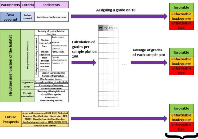
assessment of the biogeographical area scale. We also chose to follow the method of the worst parameter stipulating that the conservation status of a habitat depends on three parameters and if one of the three is not filled, then the habitat is not in favorable conservation status. Only the future prospects parameter is evaluated based on “traffic light” system, because it seemed to be too penalizing for the evaluation of the other two parameters by downgrading too quickly our different stations, we drew on the scoring method of Nathalie CARNINO. But instead of attributing regressive notes, we established a system of progressive scoring that seemed to be a more stimulating approach. Each parameter is thus evaluated by using a state conservation gradient converted to a scale of increasing ratings, ranging from the poor state of conservation at the optimum state of conservation of the habitat.
FIGURE2:CONSERVATIONSTATUSGRADIENT
2.1.2. Reference status
The conservation status of each parameter is assessed by comparing the final score obtained to a theoretical threshold value. As it was seen previously, this threshold value corresponds to a reference state beyond which the habitat is considered in favorable conservation. The definition of the reference state is only based on scientific criteria, in order to be the most objective and representative as possible. Thus, we relied on the literature and expert opinions.
2.1.3. Terminology used to define the different states of conservation
Depending on the difference between the value of the parameters evaluated and the value of the optimal state, different state can be attributed to our habitat. We chose to base
ourselves on the terminology of traffic lights proposed by the Directive : “favorable”,
“unfavorable inadequate” and “unfavorable bad" (or "unknown" when data are missing or insufficient).
2.1.4. Statement to grade
For each parameter, an evaluation system was developed and the data necessary for each indicator have to be collect on the field or by means of a medium containing the information sought such as mapping, aerial photographs, ... The data obtained are then compared with different specific thresholds which were developed for each indicator on the basis of the literature, field observations and expert statements.
• "Area covered by habitat" parameter
The study of this parameter is carried out through a system of scoring scale which was established by studying the trends of the surface covered by each station between 1964 and 1996, and between 1996 and 2011.
8
FIGURE3:CORRESPONDENCETABLEOFNOTE/CONSERVATIONSTATEOFTHE"AREACOVERED"PARAMETER
• "Structure and function of the habitat" parameter
A scoring system scale was developed with the aid of expert opinions. It is a gratifying system, the study of each indicator allows to report a number of points depending on the more or less favorable state observed, the favorable condition bringing the maximum points. It was agreed that all indicators did not affect in the same way the conservation state of the habitat. The grades attributed to each indicator have been weighted to reflect this difference.
Indicators Thresholds Grades
Percentage of recovery Dense forest or continuous thicket : [70-90% 10 discontinuous thicket : 40-70%[ 5 <40% 0
FIGURE4:STATEMENTTOGRADEBYINDICATORFORTHE“STRUCTUREANDFUNCTION"PARAMETER
The sum of all grades obtained by indicators allows then to obtain the final grade of the parameter.
Parametors Criteria Indicators Thresholds Grades
I 1 a [70-90% 30 40-70%[ 15 <40% 0 b <10% 30 >10% 0 c absent 20 present 0 2 d weak 10 strong 0 e progressive 10 regressive 0 Final grade 15 + 30 + 0 + 10 + 0 = 55
9
The grade obtained will then be plotted on the scale of the gradient evaluation and will allows to situate the parameter within a conservation status category.
FIGURE6:CORRESPONDENCEAXISOFNOTE/CONSERVATIONSTATEOFTHE"STRUCTUREAND FUNCTION”PARAMETER
The threshold values determination was based on those of the CARNINO method.
FIGURE7:CURVEOFGRADESOBTAINEDBYSTATION
Indeed, by studying the curve of grades obtained by station, it is possible to observe two breaks in the continuity of the curve. However, these two break points correspond to the threshold values proposed by the CARNINO method.
• "Future Prospects" parameter
The indicators selected to assess this parameter being to the number of two, the determination of the conservation status was carried out using a crosstab, the presence of two negative indicators giving an unfavorable bad status, the presence of a favorable and an unfavorable indicator inducing unfavorable inadequate status, and finally the presence of two favorable indicators assigning a favorable state to the station.
FIGURE8:CORRESPONDENCETABLEOFNOTE/CONSERVATIONSTATEOFTHE"FUTUREPROSPECTS” PARAMETER
2.1.5. Evaluation scales
Depending on indicator type data will be filled at two different scales : at the sampling unit (sample plot) or polygon (station). It will be possible to obtain a stational assessment grade of the conservation status from information collected at the scale of sample plot and station.
10
The whole grades obtained by each station will allows to obtain an overall note of the conservation status assessment at the site scale.
The method that we were used to pass to the stational scale assessment at the site scale evaluation will be detailed later.
3.
Sampling modalities
3.1.
Available data
Following the appointment of SMCG as animator and operator of the Objectives Document (DOCOB) of the “Petite Camargue” Natura 2000 site written between 1996 and 2007, a first mapping work of habitats of "Petite Camargue" SCI was then performed by the SMCG. In order to update the data and to follow up the habitats evolution, a second mapping campaign was conducted by ECOMED (Ecologie et Médiation) in 2011. A GIS layer was then performed to present an exhautive inventory of terrestrial habitats on the site.
As habitats form a complex mosaic, the majority of polygons covers and comprises several habitats. At each polygon, habitats were rated in habitat 1, 2 and 3 according to their areal proportion. For example, on wooded dunes, it is not uncommon to find a juxtaposition of the coastal dunes with Juniperus spp. habitat (2250) and wooded dunes with Pinus pinea and/or
Pinus pinaster habitat (2270). The choice of stations on which to base this study was lean on
the second mapping work (Appendix 2). By contrast, we were not interested at the first mapping because the realization method and the data showed important differences with that of ECOMED.
3.2.
Sampling unit
Data are to be entered from two different scales depending on the concerned indicator. Indicators on the floristic composition will be for example entered with sample plots, and those concerning a larger scale, such as the wind erosion degree will be entered on the scale of the station.
3.3.
Sampling plan
Surface and characteristics of the Natura 2000 site does not allow to sample all of the stations, and for reasons of time and measurements reproducibility, we limited ourselves to the sampling of 30 stations ; 30 were recognized in the literature as the minimum required for a sufficient sampling effort and to obtain statistically representative results of the entire study area (FIERS, 2003).
A first step was to eliminate from our pool stations considered as inaccessible by the observer. We also decided to sample both the juniper dunes noticed in habitat 1 and 2 by the ECOMED mapping, assuming that even if the juniper was in a minority, the habitat was still present. Then, with the aid of the identifier associated with each polygon in the ECOMED mapping and an Excel spreadsheet, we have randomly drawn lots of 30 stations on the whole site, a polygon corresponding to a station (Appendix 3).
We decided to realize our statements in fixed sample plots of 100m² whose the area allowed to cover a fairly large area to study a tree species such as Juniper Phoenicia, and to notice the potential presence of nitrophilous, , halophytic, destructuring or invasive alien species.
11
To do so, 30 grids of 10x10m were superimposed on each
of the 30 stations with the QGis software.
A defined number of squares was then randomly drawn through the same process as for the stations. The determining of the number of plots per station to be sampled is based on the area of each station :
TABLE 1:NUMBEROFSAMPLEPLOTSTOBESAMPLEDWITH REGARDTOTHESTATIONAREA(AGENCEDESFORETSPRIVEESDE L’OUTAOUAIS,2014)
This sampling method does not allowed to make phytosociological samples, simply because the position of the sample plots being too random, these could cover non-homogeneous transition zones at the level of characteristics of the environment and/or vegetation. Floristic inventories were carried out indicatively by the notation of plant species present.
3.4.
Sampling period
In order to observe and determine the greatest number of spring and summer annual species, the field phase took place over a period of one month, straddling between the months of May and June.
4.
Criteria and indicators withheld to assess the conservation status
Select a set of criteria and indicators is not easy because they must be able to synthesize all the mechanisms allowing the proper functioning of the habitat.
In addition, the sampling of associated data must be simple, not expensive, both in time and financially, and should not require too many skills to be applicable by the largest number. The method should therefore be based on the study of qualitative and/or quantitative simple indicators, in a limited number. The choice of indicators should be relevant, each indicator will have to provide maximum data with regard to criterion and parameter that we want to evaluate (FIERS, 2003).
They must also be selected on purely scientific basis, and without any political or social considerations. Any "co-construction between ecological principles and social choices" will be made later during the choice of management (ARGAGNON, 2012).
The choice of criteria and indicators as we think most relevant to assessing the conservation status of the coastal dunes with Juniperus spp. habitat (2250) is based on :
FIGURE9:GRIDANDSAMPLEPLOT
12
_ a bibliographic analysis treating of the different methodologies used for assessing the conservation status of habitats across the site. Various publications, documents, texts were also examined to understand the functioning, characteristics, and processes allowing the existence and maintenance of this habitat.
_ expert opinions
_ observations and field tests to compare our indicators with the reality of the field.
A list of criteria and associated indicators was thus developed and synthesized in the form of a table (Appendix 4). At each indicator is associated a method and a scale of data gathering, threshold values and associated grades. Each indicator will be thus evaluate using qualitative and/or quantitative variables whose values will be compared to threshold values. The determination of threshold values was based as much as possible on the literature and were verified in the field.
4.1.
"Area covered by habitat" parameter
4.1.1. "Evolution of surface covered" indicator
The evaluation of the surface covered may be studied by the establishment of a long-term follow-up in order to obtain an evolutionary trend that would allow to determine if the habitat is stable, grow or decline. The highlighting of this trend can be carried out by comparing mapping, current and old aerial photographs, or with the aid of expert opinions and archives.
In the present study, as we did not have the necessary information, we tried to go get them and to create them on our own. We recovered thus old aerial photographs on the Géoportail website which we then georeferenced using QGis software. We selected two sets of photographs from 1964 to have an overview of the site before the strong expansion of the Grau du Roi town associated with the “Mission Racine”, and 1996 corresponding to the DOCOB writing for SCI “Petite Camargue”. The second step was to realize an approximate mapping of our 30 stations on these two dates. The area of our two new sets of polygons were compared to those of polygons of the ECOMED mapping through a graph of trend curves done in Excel.
Example :
FIGURE10:ASSESSMENTOFTHEEVOLUTIONOFAREACOVEREDBYCOMPARISONOFTHESTATIONMAPPING
13
4.2.
« Structure and function of the habitat » parameter
4.2.1. « Morphodynamic processes » criterion
• “Entirety of typical habitat structure » indicator
Wooded dunes are ecosystems being part of a larger system, the dune system, the whole forming a mosaic of habitats in close interaction. Wooded dune is thus an element of the dune system and can be form and exist only if the spatial succession of other dune habitats exist.
We can thus imagine that a habitat in favorable conservation status would correspond to an ecological unit included in the most complete and orderly succession of habitats of the dune system. The indicator is thus based on the presence/absence and the sequence of the different dune habitats : beach, embryonic shifting dunes, shifting dunes along the shoreline with Ammophila arenaria and Crucianellion maritimae fixed beach dunes. An inversion of this sequence would be a first index of modifications which would have affected or which would affect morphodynamic mechanisms dunes. Then, degressively, it could be observed an incomplete orderly succession, followed by an incomplete disorderly succession. Finally, the addition of habitats artificialisation and/or a fragmentation of the ecological continuity by activities/human infrastructures would have an additional impact on ecological and landscape functions of the system by isolation of habitats.
On the premise that plants are distributed along the coast and inland depending on various environmental gradients (temperature, salt content of water and soil, humidity and wind), the verification of the presence of representative plant species of different dune habitats can be achieved by transects, either on the field or using a habitats mapping, oriented perpendicularly to the coastline, starting from the beach to the evaluated station. To facilitate observations on the field, a list of representative indicator species of the spatial succession of dune habitats was developed using literature and expert opinions.
• « Ecological connectivity of the stand » indicator
The establishment of human infrastructures around or directly on the dune causes irremediably significant changes in plant associations through the degradation or destruction of vegetation, and changes in morphodynamic processes due to leveling and compaction of sand, or due to a modification of the soil composition.
Direct observation on the field or through aerial photographs of the presence of human infrastructures fragmenting or surrounding habitat will have to be specified by an indication of the presence/absence, and a detail on the type of structure will have also to be entered. When several stations very close to each other but separated by human infrastructure will be observed, it will be interesting to ask whether they originally were not a single habitat. This can be verified by comparing current and old photographs.
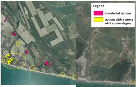
• « Wind Erosion Degree » indicator
The wind was recognized as a major driver of morphodynamic processes of the dune system. The construction, the remodeling, but also the different habitats succession are related to the strength and intensity of the winds.
14
In fact, according to their orientation and intensity, winds can cause uprooting of smaller plants but also a loosening of shrub and tree species, thereby exposing the sand. This phenomenon accentuates the erosion of the substrate, creating trough blowouts, saucer blowouts (caoudeyres) ...
The evaluation of these processes of wind erosion can be estimated visually by the observer on the entire station based on three thresholds (according to the method of Jean FAVENNEC elaborated during follow-up dunes by the ONF in 2008):
_ "absent/low": no wind erosion and/or start of erosion, forming a "cliff" and start of trough blowouts;
_ "strong" : presence of "cliffs" with large trough blowouts with start of caoudeyres; _ "very strong": several large caoudeyres of 30 to 50 m
4.2.2. « Vegetation Cover » criterion
• « General condition of individuals » indicator
The Phoenician juniper is a xerothermophilous, frugal and halophobic species that grows optimally at the top of fairly high dunes. Any change in the topography, typology of soil, the fresh/salt balance water, can cause a decay of junipers.
Individuals state can be visually assessed at each sampling plot using the thresholds relating to the foliage state of each juniper, inspired by a study conducted by the ONF in 2001 (LARROQUE et al., 2001) :
_ Good vigor : the majority of individuals has a crown more than 50% green _ Bad vigor : 50 to 70% of individuals have a crown at least 50% green; many scorched leaves, many bare/dead branches
_ Very bad vigor/death : more than 70% of individuals have a damaged crown, dead branches ; dead individuals
• « Percentage of recovery » indicator
The climax stage in dune environment is a continuous thicket of Juniperus phoenicea subsp
lycia that in rare cases evolves to a low dense forest.
Determination of threshold values is based on these studies, field observations and expert opinion. The evaluation of the recovery percentage can thus be estimated visually in each sample plot:
_ [70-90% (low dense forest/continuous thicket) : shrubland/woodland formation constituted almost exclusively of juniper
_ 40-70%[ (discontinuous thicket) : shrubland hardly penetrable, constituted of juniper and some Pistacia and Phillyrea, may have openings
_ <40% : very sparse formation being consisted by only very few junipers
• « Dynamic of renewal » indicator
Regeneration of this habitat type can be visually assessed during surveys per sample plot using three trends:
15
_ Progressive : presence of young individuals (single strands between 20 and 50 cm (LARROQUE, 2001))
_ Regressive : death of mature individuals and no young
4.2.3. « Floristic Composition » criterion
• « Recovery of halophilic and nitrophilous species » indicator
Any change in the plant association is a good indicator of the pressures that can undergo a habitat. The presence of nitrophilous and/or halophilic species may reflect a change in the quality of the fresh groundwater. Indeed, a change in the fresh/salt water can promote the development of halophilic species. The presence of nitrophilous species may on the other hand be related to a nutrients water and soil saturation and nitrogen can be linked to human activities (agricultural activities, fertilizers, ...) or to a strong habitat use by wildlife (large ungulates, rabbits, ...).
To determine the percentage of observed species per sample plot, we calculate the ratio:
ℎ ℎ ℎ
100
To do this, a non-exhaustive species list was elaborated with the aid of expert opinions. From the literature, it will be admitted that from a threshold of 10% nitrophilous and/or halophilic species, the impact on the conservation status will be considered strong (GOFFE, 2011).
• « Recovery of destructuring species » indicator
Junipers forest constitutes the climax of wooded dunes located near the coast. But when one moves away from the coastline and one sinks inland, reducing environmental gradients (temperature, salinity, pH, wind ...) will lead to the establishment of other essences types and other climax formations such as Pinus pinaster and Pinus pinea formations in coastal dunes, and oaks formations in the fluvial dunes.
The development of these species represents an index of change in the functioning of the dune unit. The assessment of this indicator be made by using floristic inventories at sample plots level that will allow to calculate the ratio:
100
According to the literature, it will be accepted that from a threshold of 10% of destructuring species, the impact on the conservation status will be considered strong (GOFFE, 2011).
4.3.
"Future Prospects" parameter
This parameter is used to group criteria and indicators that could have a future impact on the other two parameters, and thus on the sustainability of the habitat.
16
4.3.1. "Invasive alien species" indicator
In order to study the problem and risks associated with invasive plants, it was established in 2001 the "Invasive Plants" program in Languedoc-Roussillon and PACA managed by the CBN MED. A list of species was thus developed and accompanied by a prioritization system at three levels of risk (low, intermediate and strong) to the environment during the introduction of exotic species.
This list allowed us to establish a non-exhaustive list of species that could be seen at our habitat. The presence and the establishment of one of these species could cause major changes, or the disappearance of our habitat. The observer will thus have to indicate at each sample plot if he had observed or not the presence of one of these species.
4.3.2. « Areas with regulatory and/or landholding protection » indicator
A site being part of an area with regulatory protections such as Regional Nature Reserve (Réserve Naturelle Régionale) or classified sites (Sites classés) will have a protection status guaranteed by the state and managed by the French Code of the environment that may lead to the establishment of measures of protection and management of habitats and protected species living there. Landholding contol by organizations such as French Natural Area Conservatories (Conservatoires d’Espaces Naturels) or French coastal Conservatory (Conservatoire du littoral) also allows to contribute to the conservation of natural heritage. We can thus imagine that environments which are subject to these regulations will have more chance to continue than if they belonged to private owners, either who would not necessarily be inform of the ecological and heritage value of their property, or who would have not necessarily the means to manage and protect them, or who would not exercise activities contributing to the maintenance of biodiversity within their property.
This status must be taken into account by the manager at the level of future prospects assessment by noting if the station is part of an area with regulatory or landholding protection.
5.
Statement to conservation status grade at site scale
5.1.
At station scale
Conservation status assessment can be achieved at first at the station scale. Each of the three parameters is assessed, the evaluation being made directly at the station scale for parameters related to the covered area and future prospects, and at the scale of sample plots for the “Structure and function” parameter. The methods of allocating the conservation status of stational scale is detailed in section 2.2.4.
17
Results obtained at this scale can serve as support management tools because they allow to locate stations in more or less favourable state, but also to provide information about factors having an important impact on different areas or on the whole site. This information will help the manager to improve or to focus management effort by sector and factors affecting more or less the conservation state of these environments.
5.2.
At site scale
In a second time, we extend the information provided by each parameter of all sample plots at the site scale. To do so, we calculate the average of grades obtained in each sample plot for parameters relating to the area covered and the structure and function. This grade is then used to determine the conservation status of these two parameters at the site scale.
For "Future prospects" parameter we look at the percentage of stations with an unfavorable inadequate, unfavourable bad and favorable state, and we retain the state that was most frequently observed on all stations.
18
FIGURE12:STATIONALGRADETOATTHECONSERVATIONSTATUSASSESSMENTATSITESCALE
The parameter that will be finally the lowest rated of the three will define the conservation status of the site.
II.
Results of the conservation status assessment
of the coastal dunes with Juniperus spp.
We sampled a total of 30 stations, or 49 sample plots spread throughout the Natura 2000 site. Our method for drawing lots seemed to us representative because we obtained a pool of stations located in both private and communal plots of land of the Espiguette plain, and in the private ownership of the Salins du Midi.
Three stations (2141, 2142 and 4705) were not used for the scoring because no juniper was observed there. The 2141 and 2142 stations showed marks of fire with damaged pine trees, most likely due to the presence of an electric line which is regularly the cause of fire starts in this area. For all other sample plots and stations, all indicators was identified and assessed using the evaluation grid that we developed.
1.
Statistical analysis of data
Following the field period, data were analyzed using statistical tests to evaluate the possible correlation between these indicators. In fact, we wanted to ensure that our indicators did not provide redundant information that could apply a double penalty at scoring. Our indicators being qualitative variables, and as one of the rules of the chi-square test of
19
independence was not met, our theoretical numbers being not always higher than the threshold of 5, we performed a Fisher's exact test to using the software R. The results showed that at a threshold of 5%, the "dynamics of renewal" indicator was correlated with indicators on the wind erosion degree, the general condition of individuals and the percentage of recovery, and the percentage of recovery was also correlated with the " Entirety of the typical habitat structure" indicator. By lowering the threshold at 1%, the correlation was then just significant between the indicators on the general condition of individuals and the dynamics of renewal (Appendix 5).
By lack of understanding and by the difficulty of integrating these results in our study, but also because we did not know if it meant to have to choose and to remove one of these two indicators, we provided them a grade and an identical weighting coefficient at the level of the scoring scale, with the aim of not losing information that seemed important, given by each of these indicators.
2.
Results
2.1.
« Area covered » parameter
In general, observations of the most significant changes occur between 1964 and 1996 (Appendix 6). The simple visual comparison of the mapping from 1964 with those from 1996 and 2011 shows major changes, easily observable mainly at stations close to the coastline, with significant morphological changes (452 station), significant loss of surface covered (2022 station) or migration (4745 station). On the contrary, stations located further inland seem to present more stable or progressive evolutionary trends.
The proportion of stations with a steady, progressive or regressive evolutionary trend is more or less similar. The calculation of the average of all grades by station therefore confers an unfavorable inadequate conservation state for this parameter at the site scale.
2.2.
« Structure and function » parameter
0% 10% 20% 30% 40% 50% 60% 70% 80% 90% 100%
unfavorable bad unfavorable inadequate favorable
20
The comparison of the proportion of station with favorable, unfavorable inadequate and unfavorable bad conservation status for each indicator of the "Structure and Function" parameter allowed us to better visualize the factors most impacting at the site.
Thus, we can see at the scale of territory, the general condition of junipers is globally good, and the dynamic of renewal is mostly progressive or stable. The percentage of recovery is for its part quite low with only 10% of the stations which present the optimal state supposed to be observed at this habitat.
At the scale of the station, we can observe that ecological connectivity of the stand is quite significantly impacted by human infrastructures. Almost half of the stations are fragmented, surrounded or separated from nearby stations by various buildings (houses, roads, agricultural wasteland, ...). In addition, few stations (about 10%) are part of a dune system with a complete and orderly succession.
Using the mapping analysis tool, we were able to observe and confirm our assumptions that the stations which are most affected by wind erosion are located just behind the shoreline. The situation is however not catastrophic because no stations undergoes a very high wind erosion degree that could be highly harm to their conservation status.
FIGURE14:LOCALIZATIONOFSTATIONSWITHASTRONGWINDEROSIONDEGREE
Finally, the great majority of stations (75%) does not present destructuring species which is comforting for the sustainability of this habitat, knowing that the only destructuring species which were observed are the main competitors of Phoenician juniper : Pines. By contrast, nearly 80% of the stations have a high proportion of nitrophilic and halophilous species.
The calculation of the average of grades obtained by station allows to define the
conservation status of this parameter as unfavorable inadequate.
2.3.
« Future prospects » parameter
No invasive species were observed on the sampled stations. It is thus only the criterion relating to the landholding which could allow to tip the conservation state of favorable to unfavorable inadequate. Of the 27 stations evaluated, 14 belong to private owners and 11 to the French coastal Conservatory. Two are both on private land and land owned by the Conservatory. As a precautionary measure, we decided to evaluate them as being in unfavorable inadequate state.
21
The majority of stations being in unfavorable inadequate state, the conservation status of
this parameter at the site scale was therefore assessed as unfavorable inadequate.
2.4.
Final grade at site scale
The three parameters were assessed as being in unfavorable inadequate conservation status. By application of the worst parameter, the conservation status of the coastal dunes with Juniperus spp. habitat (2250) across the "Petite Camargue" Natura 2000 site is thus
unfavorable inadequate.
PARAMETERS CONSERVATION
STATUS
CONSERVATION STATUS ASSESSMENT AT SITE SCALE
Area covered unfavorable
inadequate
unfavorable inadequate Structure and function of the
habitat
unfavorable inadequate
Future Prospects unfavorable
inadequate
TABLE2 :CONSERVATIONSTATUSASSESSMENTACROSS« PETITECAMARGUE »NATURA2000SITE
III.
Discussion
•
Limitations of the method
In this study, we felt it important to study all the features of this habitat as well as ecological and anthropogenic factors that could affect its sustainability, by basing us on scientific criteria apart from any political or social considerations. Indeed, this last point should be only considered during the reflection and the establishment of management operations by the natural areas manager.
However, to develop a simple and inexpensive management support tool, we tried to be as synthetic as possible by selecting only a limited number of indicators that we felt were the most important and easier to implement by the largest number. In addition, we wanted they are representative of all the factors affecting each scale of the biodiversity of the environment (individual, stand, landscape).
The systematic assessment of all selected indicators seems thus to us to be important because it provides an objective and representative mark of damage sustained by the habitat. The method is however not restricted to our list of indicators because it wants to be an evolutionary approach depending on the characteristics of the study site and the needs of the manager.
The elaboration of the list of indicators was based on an extensive literature synthesis, on expert opinions and on the basis of field observations. We also organized tours, in particular at the « Bois des Rièges » within the National Reserve of Camargue, but also at the Phoenician juniper dunes that was recently identified at the Grand Travers site of La Grande Motte, to have an overview of the habitat outside of our study site and to test the evaluation grid. However, due to the small amount of bibliographic information and the lack of studies on the subject, weighting and threshold values were determined on expert opinions. Results
22
obtained are satisfactory, but the impact of certain indicators is difficult to assess. For example, study the succession and the integrity of the dune habitats through the "Entirety of typical habitat structure" indicator appears to be essential for assess whether the habitat is still connected or not to the dune dynamics. Data analysis was however limited, because understand the integrity of a such habitat in a complex system such as the dune system would require a study in its own right.
Statistical testswere alsoapplied on the indicators for assessinga potentialredundancy of
information they provide and which could make a double penalty at scoring. However, more powerful statistical analyzes could confirm, complete or modulate the results. In addition, being the first study on this habitat, we had no data with which to compare ours. A second evaluation with an expert on all the stations studied, will provide a basis with which to compare our data.
The method and the indicators grid were validated by experts from the ONF, the DREAL LR and the CBN MED at a meeting of internship presentation. It might be interesting that following this work, a second study be set up with a larger sampling effort, as well as further statistical analyzes to, if it need, recalibrate indicators and grades and validate the method presented in this report. It would be also interesting that it can be tested by other natural areas manager to verify if the method is well applicable outside the study site.
The work done in this study constitutes therefore a primer offering solid foundations that can be improved over the next applications, feedback and advancing knowledge in this habitat.
•
Application by the manager
The interest of the method developed in this study allows to obtain both a grade at the station and at the site scale and allows to award a value to each indicator. Thus, the manager can identify factors that affect the conservation status of the habitat and identify management efforts to provide and the location of the stations concerned.
At the “Petite Camargue” SCI, we can for example observe that factors that most affect the conservation status of the Juniper dunes habitat are the presence of nitrophilic and halophilous species, a small percentage of recovery of juniper population, the important proportion of stations fragmented and/or blocked by human infrastructures, and the very small proportion of transects of the dune system with a complete succession.
Management operations within the Espiguette dune system have already been established and should be continued, such as the restoration of agricultural wasteland that was conducted on plots of land belonging to the French Coastal Conservatory. These lands had been cultured in the 50s, leading to a leveling, a fragmentation and a drainage of dune systems. They were then abandoned, evolving rapidly in agricultural wasteland, promoting the implementation of destructuring and ruderal plant species and creating a break in the ecological continuity of the dune system. Under the "Petite Camargue" DOCOB in 2007 and the Life + Lag'Nature program in 2012, the SMCG undertook to rehabilitate these areas by puting sand back, recreating relief to allow the typical vegetation of dune habitats to reimplant there, and by removing invasive plant species, waste and other agricultural activity. This action allowed to improve the criterion relating to the entirety of habitats and to reduce the recovery
23
of nitrophilic, halophilous and destructuring species, and thus will have to be pursued, for example by land acquisition and restoration of new plots of land.
The further optimization of land use can lead to improved criteria relating to the entirety of habitats and fragmentation of the stations. Thus, the control of the fragmentation of communal plots with the channelling of the public and the protection of particularly sensitive stations will allow to limit the fragmentation and degradation of dune habitats. The establishment and maintenance of “ganivelles” may also be pursued on very busy areas to consolidate the dune, to channel the attendance and to preserve wooded dune habitats.
In addition, the work conducted by the SMCG on the establishment of a comprehensive strategy to fight against the destructuring invasive alien species will also be continued.
All these actions must be accompanied by awareness campaigns for the preservation of dune habitats of local and tourist population, but also of local stakeholders and private owners.
Finally, it should be noted that some of these criteria are not directly resulting from the management but are uncontrollable natural factors by management, related to the history and dynamics of the Rhone delta. Marine erosion is one of them and is currently a central concern. Major rehabilitation works of the second dune ridge at the Espiguette massive will start in October 2014 until February 2015. It is under the “Contrat de Projet Etat-Région”, and as animator of the “Opération Grand Site Camargue gardoise”, the SMCG conducted preliminary studies in this rehabilitation works. This project aims to recreate a connection between the sand ridges of the second line, and ultimately, will allows to re-create a natural barrier against coastal flooding and a protection of dune ecosystems.
It may be interesting to update the HCI mapping of Espiguette site in a few years, with an application in parallel of this assessment of the conservation status method, in order to have an overview of the impact of rehabilitation works of the second dune ridge on natural environments and in particular on the Juniper dunes habitat.
• Putting in perspective of the local assessment to the national assessment
Synthesis and sharing of local data, in case of application of the method by several managers, provides an overview of the habitats evolution at national scale by biogeographical area and contributes to the surveillance and the assessment of the conservation status of HCI provided for by Habitats Directive.
At European level, the data obtained locally allow to have a global view of the conservation status of habitats and to check if the objectives of Community policy are met.
They also allow to have an overview of the main threats affecting the large sets of habitats. For example, following the first campaign of evaluation, it was found that the vast majority of coastal and marine habitats were in unfavorable bad or unfavorable inadequate conservation state mainly due to the decrease in their range, but also due to surface losses and degradation of their functioning due to heavy tourist pressure and urbanization.
24
IV.
CONCLUSION
This study allowed to lead to a standardized evaluation method of the conservation status, based on a small but pragmatic list of criteria and indicators fairly simple to sample, and directly applicable by the largest number. It will thus provide valuable assistance to natural areas managers and help to enhance the overall knowledge of the state of this dune habitat. Across the “Petite Camargue” Natura 2000 site, it led to the conclusion that the Coastal dunes with Juniperus spp habitat is in unfavorable inadequate conservation status because its three parameters were evaluated unfavorable inadequate, whereas at the national level, this habitat was assessed in 2013 as being in unfavorable bad state, with a favorable range, unfavourable inadequate structure and function and unfavourable bad future prospects. The pursuit of the many actions already implemented by managers on the littoral of the “Grand Site de France Camargue gardoise” will allow to maintain and, if possible, to improve the conservation status of remarkable dune environments of the Espiguette site.