CEDRIG
Climate, Environment
and Disaster Risk Reduction
Integration Guidance
Guidance to improve resilience and reduce impacts in development cooperation and humanitarian aid
MODULE
1
RISK
MODULE
2
MODULE
3
MODULE
1
RISK MODULE2
MODULE3
IMPACTContent
CEDRIG in a nutshell 4MODULE 1: Risk and Impact Screening 7
MODULE 2: Detailed Assessment at Strategic and Programmatic Level 13
MODULE 3: Detailed Assessment at Project Level 18
A) Detailed Risk Assessment: Adaptation and DRR 19
Step 1: Assessing risks 19
Step 2: Identify adaptation and risk reduction options 26
Step 3: Select adaptation and risk reduction options 31
Step 4: Define monitoring and evaluation indicators 34
MODULE
1
RISK MODULE2
MODULE3
IMPACTCEDRIG in a nutshell
Tackling disaster risk emanating from climate variability, climate change, environmental degradation and tectonic activities is widely perceived as one of the greatest challenges faced today. These risks significantly influence the resilience of systems and communities. Developing countries are particularly vulnerable to those disaster risks due to their high dependence on natural resources and limited coping capacity. Hence, climate change, environmental degradation and natural disasters pose an increasing challenge to meeting sustainable development goals and seriously undermine core development priorities such as poverty alleviation.
The Swiss Agency for Development and Cooperation (SDC) aims to systematically integrate climate, envi-ronment and disaster risk reduction (DRR) into development cooperation and humanitarian aid in order to enhance the overall resilience of systems and communities. The Climate, Environment and Disaster Risk Reduction Integration Guidance CEDRIG is an approach to support SDC staff and their project partners in analysing whether existing and planned cooperation strategies, programmes and projects are at risk from disasters emanating from climate variability, climate change, environmental degradation and/or tectonic ac-tivities, as well as whether they have an impact on greenhouse gas (GHG) emissions and/or the environment. The guidance helps to define measures to reduce such risks and impacts and build more resilient livelihoods. It is not the aim of CEDRIG to develop targeted climate change adaptation or DRR projects but rather to consider climate, environment and DRR systematically as important factors when developing a new strategy, programme or project.
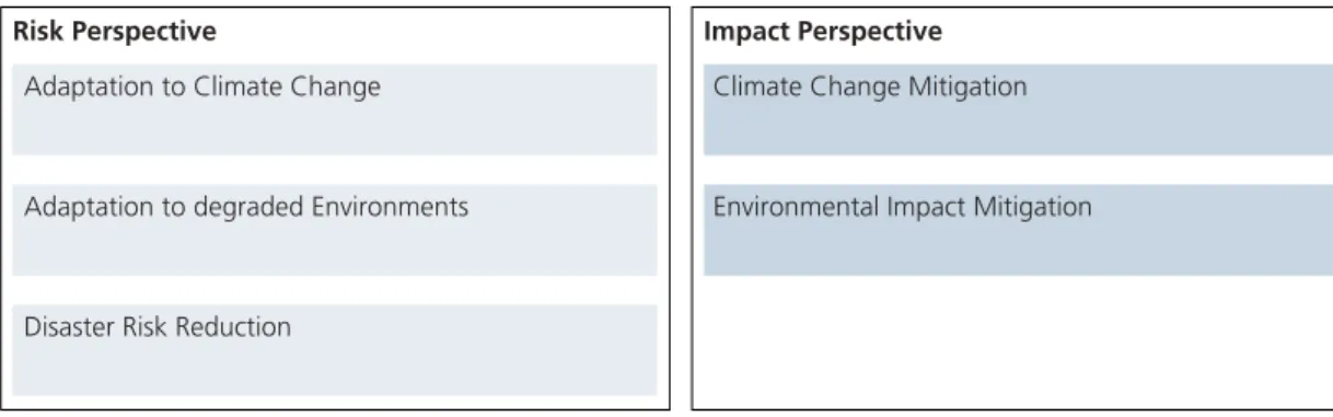
CEDRIG follows a combined approach (see Figure 1). On the one hand, it helps to manage disaster risks emanating from climate change, environmental degradation and/or natural hazards (risk perspective). On the other hand, it also helps to reduce the impacts of strategies, programmes or projects on GHG emissions and/or the environment (impact perspective). On the risk perspective, this is done by adaptation to climate change, adaptation to degraded environments and DRR. On the impact perspective, the concepts of climate change mitigation and environmental impact mitigation are applied.
Adaptation to Climate Change
Adaptation to degraded Environments
Disaster Risk Reduction
Climate Change Mitigation
Environmental Impact Mitigation
Risk Perspective Impact Perspective
Figure 1 Risk and impact perspective of CEDRIG.
CEDRIG is modular and flexible and reflects the specific requirements for integration into SDC’s project cycle management (PCM). CEDRIG is comprised of three modules as outlined in Figure 2.
MODULE
1
RISK
MODULE
2
MODULE
3
IMPACT
Figure 2 Overview of the modules of CEDRIG.
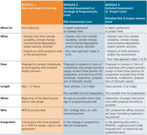
Module 1 - Risk and Impact Screening: This module (taking max. 1-2 hours) serves as an initial filter to as-sess whether strategies, programmes or projects are at significant risk from disasters emanating from climate change, environmental degradation and/or tectonic activities and whether they have a significant impact on GHG emissions and/or the environment. The result of Module 1 is used to decide whether a Detailed As-sessment must be conducted (Module 2 or Module 3). The main conclusions should be reflected in the entry proposal (for new activities) or the review (for new phase of running activities) and serve as an input for the planning process.
Module 2 - Detailed Assessment at Strategic and Programmatic Level: Module 2 (taking 2 to 3 days, without taking into account the preparation time) allows to systematically integrate adaptation to climate change, adaptation to degraded environments as well as DRR into an existing or planned strategy or pro-gramme. Module 2 is only applied when possible significant disaster risks have been identified under Module 1 and a more thorough assessment is considered necessary. At the strategic and programmatic level, the approach is called Risk Assessment Lens. The results of the Risk Assessment Lens are integrated into the strategy document and its results framework.
Module 3 - Detailed Assessment at Project Level: Module 3 allows to systematically integrate adaptation to climate change, adaptation to degraded environments as well as DRR into an existing or planned project. Furthermore, it allows systematic integration of climate change mitigation and environmental impact mitiga-tion into an existing or planned project. Module 3 is applied when possible significant disaster risks and/or impacts have been identified under Module 1 and a more thorough assessment is considered necessary. At the project level, the approach is called Detailed Risk and Impact Assessment and follows a four step ap-proach: 1) assessment of risks and impacts, 2) identification of adaptation and risk reduction options as well as mitigation options, 3) selection of options, and 4) definition of monitoring and evaluation indicators. The results of the Detailed Risk and Impact Assessment are integrated into the mandatory risk assessment in the planning documents and the logframe of SDC’s projects.
Yes No No further analysis PROJECT LEVEL STRATEGIC & PROGRAMMATIC LEVEL Step 1 Assess risks Step 2
Identify adaptation & risk reduction options Step 3
Select adaptation & risk reduction options Step 4
Develop monitoring & evaluation indicators
Step 1 Assess impacts
Step 2
Identify mitigation options
Step 3
Select mitigation options
Step 4
Develop monitoring & evaluation indicators Risk Asessment Lens
Risk Assessment: Impact Assessment: Adaptation & DRR Mitigation RISK AND IMPACT SCREENING
CEDRIG MODULE 1 MODULE 2 AND 3 MODULE 3 MODULE 2 DETAILED ASSESSMENT Are there significant risks for the activity
or impacts by the activity?
MODULE
1
RISK MODULE2
MODULE3
IMPACT MoDuLE 1Risk and Impact Screening MoDuLE 2 Detailed Assessment at Strategic & Programmatic Level
Risk Assessment Lens
MoDuLE 3
Detailed Assessment at Project Level
Detailed Risk & Impact Assese-ment
What for First screening In depth assessment at strategic level
In depth assessment at project level
What › Disaster risks from climate variability, climate change, environmental degradation and/or tectonic activities › Impacts on GHG emissions and/
or the environment
› Disaster risks from climate variability, climate change, environmental degradation and/or tectonic activities › Four step approach (steps A
to D)
› Disaster risks from climate variability, climate change, environmental degradation and/or tectonic activities › Impacts on GHG emissions
and/or the environment › Four step approach (steps 1 to 4)
How Proposed to conduct individually or participatory with involved project partners
Proposed to conduct in form of a workshop with project partners (assign at least three persons for preparation and planning of the workshop, moderation, prepara-tion of thematic inputs)
Proposed to conduct in form of a workshop with project partners (assign at least three persons for preparation and planning of the workshop, moderation, prepara-tion of thematic inputs)
Length Max. 1-2 hours Team process: 2 to 3 days Plus variable time for preparation
Team process: 2 to 3 days Plus variable time for preparation
When Beginning of the planning pro-cess or new phase
As early as possible when strat-egy or programme planned
Elaboration of project document and credit proposal (as early as possible)
Who NPO & country desk SDC strategy team, ev. with
selected partners SDC programme officer and pro-ject team (including implement-ing partner)
Integration Conclusions into entry proposal or in TOR for review, input in risk assessment
In the strategy or programme (Results framework)
In the planning document = PRODOC, Logframe and Credit Proposal (incl. its respective risk assessment part)
MODULE
1
RISK MODULE2
MODULE3
IMPACTAim
The screening aims at identifying whether a strategy, programme or project (hereafter called activity) is potentially at risk from disasters emanating from climate change, environmental degradation and/or natural hazards and whether an activity may have an impact on GHG emissions and/or the environment. For the de-scription of the term disaster risk and other definitions please refer to Box 1 in Part I (page 5). The goal is to conduct a rapid and basic assessment of risks and impacts and make the decision whether to proceed with a Detailed Assessment (Module 2 for strategic level or Module 3 for project level) or not. Please note that some risk always exists. The question is whether the probability and potential negative impacts consti-tute a significant additional risk. Therefore, disaster risks may be assessed in comparison to other risks (e.g. social, institutional etc.) for an activity that might have been identified within the regular risk assessment process in the planning phase. The screening shall be applied at a very early stage of the planning phase. It is meant to be completed in a rather generic and quick manner. The screening can be conducted with only minimal knowledge of climate change, environmental degradation and natural hazards and without access to detailed climate data.
What to do
The screening has two components: › (A) Risk Screening
› (B) Impact Screening
These should be performed by answering the key questions presented in the template format under sub-chapter “Results of the Risk and Impact Screening and tables to complete”. At the end of the process, you will make an overall estimation of the risks and impacts. Based on your estimation you shall decide whether a Detailed Assessment shall be conducted or not (Module 2 and Module 3). In general, it is recommended to pursue a Detailed Assessment if the risks are high and the capacities to cope with these risks are low. Hence, if you consider that the risks for the activity will negatively affect the resilience of systems or if the impact of the activity are high and the capacities of women and men to absorb or reduce those impacts are low, a Detailed Assessment should be conducted. The following key questions should be answered:
› Are there any significant disaster risks for the activity caused by climate change, environmental degrada-tion and/or tectonic activities, taking into account the vulnerability of the community or systems?
› Are there any significant impacts on GHG emissions and/or the environment by the activity, taking into account the capacities of the community or systems?
Please note that there is a certain level of subjectivity on what is meant by “significant” risk and subsequently on whether there is a need to conduct a Detailed Assessment.
Instructions:
Use the Risk Screening table provided on page 8 and the Impact Screening table on page 11. Tables can be downloaded from the CCE and DRR Network websites.
Elaboration of the Risk and Impact Screening
The screening will best be conducted by the national programme officer in charge of the intervention as he or she is familiar with the context and the focus of the intervention. There is no need to conduct extensive data research (although some information has to be gathered) or hold broader stakeholder consultations in order to complete this first quick screening. The time needed to conduct the screening shall not be longer than 1-2 hours. The decision whether to proceed and perform a Detailed Assessment should be taken by the responsible person at the COOF and reported in the entry proposal.
MODULE
1
RISK
MODULE
2
MODULE
3
IMPACT
Entry points and how to make use of the results
The screening is applied at the beginning of the planning process of a new activity or during the review of a running activity (see PCM in Figure 5, Part I). Main conclusions (estimation of overall risks for the activity and impacts by the activity) should be reflected in the entry proposal (for new activities) or the review (for new phase of running activities) and serve as an input for the planning process.
Results of the Risk and Impact Screening and tables to complete
›As a result of this screening, the key questions in the template checklist provided below are completed. ›Overall risks are roughly estimated.›Overall impacts are roughly estimated.
›It is decided whether a Detailed Assessment shall be conducted or not.
A) Risk Screening
RISk SCREEnInG
Questions Yes not sure1 no Explanation2
1. Exposure and hazards
1.1. Does the activity take place in at least one of the following areas or sectors?
› Agriculture and food security (including livestock and fisheries)
› Forestry (e.g. reforestation, forest management, agro forestry)
› Land use management › Water Resource Management › Biodiversity conservation › Water and sanitation
› Urban development (including land use and planning) › Health
› Infrastructure and transport (e.g. communication, roads, transport)
› Energy (e.g. hydropower) › Others
1.2. Is the activity located in any of the following types of sensitive geographical areas, zones and/or protected areas?
› Arid/semi-arid zones › Tundra
› Mountain ecosystems › Small islands › Coastal regions
› Deltaic areas, flood plains, alluvial fans, peat land › Zones exposed to (tropical) storms
› Zones exposed to extreme cold and/or snowfall › Zones within the reach of volcanic activity › Zones exposed to landslides
› Seismic zones
› Zones exposed to wildfire
12
1 It will not always be possible to respond clearly with “yes” or “no” to a particular question; in this case “not sure” should be marked.
2 Add a comment if you feel that a clarification or explanation is necessary, e.g. speci-fying the type of activity (from the listing) that is concerned.
MODULE
1
RISK
MODULE
2
MODULE
3
IMPACT
Questions Yes not sure1 no Explanation2
› Zones exposed to biological hazards (e.g. locust) › Zones exposed to chemical hazards (pesticides,
chemi-cals)
› Zones in the vicinity of hazardous material (e.g. vicinity to industrial plants)
› Zones exposed to heavy air pollution › Primary forests
› Others
1.3. Are the objectives of the activity affected by one of the following hazards?
› Shifts (special and temporal) in mean temperature and rainfall patterns
› Extreme temperature and precipitation events › Droughts
› Storms and/or cyclones › Volcanic eruptions
› Earthquakes (including tsunamis) › Mudflows, landslides
› Rock-, snow-, ice-avalanches › Floods, inundations › Deforestation › Desertification › Wildland fires
› Degradation (land, soil, ecosystems, biodiversity) › Soil, water and air pollution (including contamination
by hazardous material) › Other natural hazards
1.4. Do the hazards above significantly endanger the achievement of the objectives of the activ-ity?
The activity is significantly endangered if it is located in a sec-tor and in a geographical area exposed to hazards. To answer the question, an overall evaluation of questions 1.1–1.3 is needed: …….
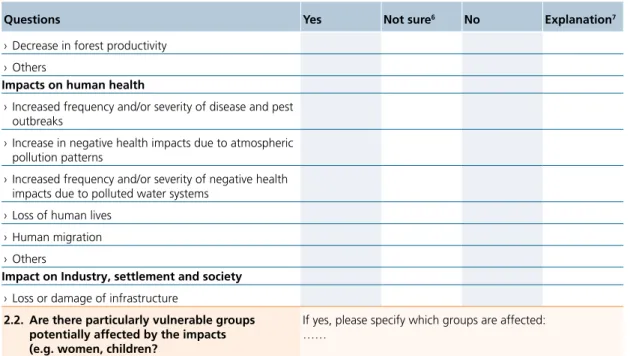
2. Impacts and Vulnerability
2.1. If the activity is exposed to hazards mentioned above, which impacts do you expect? Impact on water resources and their management
› Increased frequency of high flow events (floods) › Increased peak flows, runoff and river bank erosion › Seasonal or permanent reduction in the availability of
freshwater, e.g. seasonal changes in stream flows › Increased pathogens and disease vectors as a result of
higher water temperature (e.g. malaria) › Decrease in water resource quantity and quality › Others
Impact on coastal systems and low-lying areas
› Raised sea level and increases of coastal erosion › Changes in wave direction
› Others
Impacts on ecosystems, their properties, goods and services
› Loss or shifts of habitats and changes in ecosystems › Acceleration in desertification, soil loss and erosion
processes
› Increased and accelerated land sliding
› Increased pollution of ecosystems, soils and lands
Impacts on food and forest products
MODULE
1
RISK
MODULE
2
MODULE
3
IMPACT
Questions Yes not sure6 no Explanation7
› Decrease in forest productivity › Others
Impacts on human health
› Increased frequency and/or severity of disease and pest outbreaks
› Increase in negative health impacts due to atmospheric pollution patterns
› Increased frequency and/or severity of negative health impacts due to polluted water systems
› Loss of human lives › Human migration › Others
Impact on Industry, settlement and society
› Loss or damage of infrastructure
2.2. Are there particularly vulnerable groups potentially affected by the impacts (e.g. women, children?
If yes, please specify which groups are affected: ……
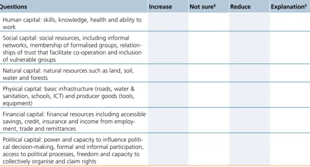
2.3. Which of the following factors reduce their vulnerability? Which of the following factors increase their vulnerability?
Questions Increase not sure3 Reduce Explanation4
› Human capital: skills, knowledge, health and ability to work
› Social capital: social resources, including informal networks, membership of formalised groups, relation-ships of trust that facilitate co-operation and inclusion of vulnerable groups
› Natural capital: natural resources such as land, soil, water and forests
› Physical capital: basic infrastructure (roads, water & sanitation, schools, information and communication technologies (ICT) and producer goods (tools, equip-ment))
› Financial capital: financial resources including savings, credit, insurance and income from employment, trade and remittances
› Political capital: power and capacity to influence politi-cal decision-making, formal and informal participation, access to political processes, freedom and capacity to collectively organise and claim rights
2.4. Do you estimate that communities and systems involved in the activity are potentially vulner-able to the impacts under 2.1?
Make an overall evaluation of 2.1. to 2.3: ……
3. overall estimation of the risk for the activity 3.1. Based on the evaluation 1.4 and 2.4, do you
estimate that there are significant risks for the activity and that a Detailed Assessment should be carried out?
Yes No
In general, it is recommended to do a Detailed Assessment if the activity is significantly endangered by impacts and the vulnerability is high.5
3.2. If a Detailed Assessment shall be carried out, go to Part II, Module 2 (for strategic and programmatic level) or Module 3 (for project level) part A.
Table 1 Risk Screening.
1 2
3 It will not always be possible to respond clearly with “yes” or “no” to a particular question; in this case “not sure” should be marked.
4 Add a comment if you feel that a clarification or explanation is necessary, e.g. specifying the type of activity (from the listing) that is concerned.
5 Please note, that also in case of unclear effects (many times “not sure” marked), it might be advisable to conduct a Detailed Assessment.
MODULE
1
RISK MODULE2
MODULE3
IMPACTB) Impact Screening
IMPACT SCREEnInG
Questions Yes not sure6 no Explanation7
1. Exposure and impacts
1.1. Does the activity take place in at least one of the following areas or sectors?
› Energy generation and distribution › Transport
› Construction (housing, infrastructure, etc.) › Industry
› Agriculture (including livestock) and rural development › Water
› Urban development (including land use and planning) › Tourism
› Forestry
1.2. Is there a risk that the activity produces the following negative impacts on GHG emissions and/or the environment?
› Impacts on increasing GHG emissions
› GHG emissions by operation of buses, cars, airplanes, ships, trains, etc.
› GHG emissions by generation and distribution of en-ergy (e.g. diesel generator)
› GHG emissions from heating, cooling and construction of buildings
› GHG emissions by digestion processes of cattle and other ruminant animals (production of fermentation gases) and manure concentration in more intensive systems
› Others
negative impacts on water
› Impacts of infrastructure on natural water regimes › Contamination of water through pesticides, chemicals › Siltation of reservoirs
› Water pollution, changes in groundwater resources, depletion of water resources
› Others
negative impacts on air
› Release of air pollutants by operation of buses, cars, airplanes, ships, trains, etc.
› Release of air pollutants by generation and distribution of energy (e.g. diesel generator)
› Release of air pollutants from heating, cooling and construction of buildings
negative impacts on ecosystems
› Impacts of infrastructure on ecosystems etc. (e.g. new access roads)
› Deforestation by excessive consumption of fuel wood › Deforestation, forest degradation and unsustainable
land use
1 2
6 It will not always be possible to respond clearly with “yes” or “no” to a particular question, in this case “not sure” should be marked.
7 Add a comment if you feel that a clarification or explanation is necessary, e.g. speci-fying the type of activity (from the listing) that is concerned.
MODULE
1
RISK
MODULE
2
MODULE
3
IMPACT
Questions Yes not sure6 no Explanation7
› Resource use displacement: protected areas may increase the pressure on other resources › Unsustainable use of natural resources › Others
negative impacts on soils
› Impacts of infrastructure on soil
› Contamination of soils through pesticides, chemicals › Soil degradation, desertification, erosion and
acidifica-tion
› Microbial transformation of nitrogen fertilisers in soils › Others
1.3. Is there a significant risk that substantial
nega-tive impacts are caused by the activity? To answer the question, make an overall evaluation of 1.1 and 1.2: …….
2. Capacities
2.1. Which of the following factors increase or reduce the capacity of people to reduce the impact of the activity?
Questions Increase not sure8 Reduce Explanation9
› Human capital: skills, knowledge, health and ability to work
› Social capital: social resources, including informal networks, membership of formalised groups, relation-ships of trust that facilitate co-operation and inclusion of vulnerable groups
› Natural capital: natural resources such as land, soil, water and forests
› Physical capital: basic infrastructure (roads, water & sanitation, schools, ICT) and producer goods (tools, equipment)
› Financial capital: financial resources including accessible savings, credit, insurance and income from employ-ment, trade and remittances
› Political capital: power and capacity to influence politi-cal decision-making, formal and informal participation, access to political processes, freedom and capacity to collectively organise and claim rights
2.2. Do you estimate that women and men involved in the activity have the capacities to manage the risks of negative impacts identified in 1.3?
Make an overall evaluation of 2.1 taking into account 1.3: ……
3. overall estimation of the impact of the activity 3.1. Based on the evaluation 1.3 and 2.2 do you es-timate that there are significant impacts by the activity and that a Detailed Assessment should be carried out?
Yes No
In general, it is recommended to do a Detailed Assessment when assessed impacts are high and capacities of women and men to reduce those impacts low.10
3.2. If a Detailed Assessment should be carried out, go to Part II, Module 3 (for project level) part B.
Table 2 Impact Screening.
1 2
8 It will not always be possible to respond clearly with “yes” or “no” to a particular question; in this case “not sure” should be marked.
9 Add a comment if you feel that a clarification or explanation is necessary, e.g. specifying the type of activity (from the listing) that is concerned.
10 Please note, that also in case of unclear effects (many times “not sure” marked), it might be advisable to conduct a Detailed Assessment.
MODULE
1
RISK
MODULE
2
MODULE
3
IMPACT The Risk Assessment Lens (Module 2) shall be applied when the screening (Module 1) indicates a need
for conducting a Detailed Assessment. The methodology for this assessment targets a different level of consideration (more strategic) than the project level (Module 3). Module 2 outlined in this section aims at strategies such as country, sector or cooperation strategies. Also complex programmes may be better as-sessed with this module. For practical reasons, only reference to the strategic level is made in the handbook. The process of CEDRIG at strategic and programmatic level and the inter-linkages between Module 1 and Module 2 are shown in Figure 4.
Yes
No
No further analysis
MODULE 1: Risk and Impact Screening
MODULE 2: Risk Assessment Lens Are there
significant risks for the
strategy?
Who
COOF/ headquarter COOF/ headquarterCEDRIG at strategic and programmatic level
Integrating
the results
Review of strategy or concept of strategy
Strategy (risk assessment) Figure 4 Module 1 and 2 at strategic and programmatic level.
Aim
The Risk Assessment Lens focuses on the assessment of disaster risks emanating from climate vari-ability, climate change, environmental degradation and/or tectonic activities. For the details con-cerning the equation of disaster risks and further definitions please refer to Box 1 in Part I (page 5). The aim of applying the Risk Assessment Lens is to appraise whether the strategic goals, objectives or priorities are at risk from disasters and conceive a strategy which is more effective at reaching its objectives increas-ing the resilience of systems and communities. Incorporatincreas-ing disaster risks emanatincreas-ing from climate change particularly require planning with longer time scales and a wider range of possible variability in mind. The Risk Assessment Lens shall be applied as early as possible in the planning of a new strategy or programme or a new phase of an existing strategy and programme (e.g. during the planning workshop).
MODULE 2: Detailed Assessment
at Strategic and Programmatic Level
MODULE
1
RISK MODULE2
MODULE3
IMPACTWhat to do
A. Analyse the context of climate change, environmental degradation and natural hazards Try to assess whether and how the strategy under consideration will be affected by climate change, environ-mental degradation and/or natural hazards. You may also take into account existing risk scenarios. Please note that this is a qualitative assessment where a certain scope of discretion is left for the persons conducting this analysis. The assessment made in this step shall be included into the context analysis of the strategy docu-ment. While doing this assessment you should be able to answer the following three key questions: ›What are the most important natural hazards also related to climate change and environmental
degrada-tion in the country, region or sectors?
›What are the relevant factors influencing current and future vulnerability?
›Which key national development priorities, geographical areas, and/or sectors are likely to be particularly affected by climate change, environmental degradation and/or natural hazards?
Instructions:
›Complete the provided reporting format (Table 3, page 15). Table can be downloaded from the CCE and DRR Network websites.
›Consult the following available national information sources as appropriate: National Communications to the United Nations Framework Convention on Climate Change (UNFCCC); National Adaptation Pro-grammes of Action (NAPAs, for LDCs11); in future National Adaptation Plans (NAPs); national
implemen-tation reports (e.g. midterm review, HFA Monitor) of the UN ISDR’s HFA 2005–201512; Common
Coun-try Assessment (CCA) of the United Nations Development Assistance Framework, GFDDR’s CounCoun-try Pro-grammes13, World Bank Country Assistance Strategies (CAS); World Bank’s Country Environmental
Analy-sis (CEA); National Environment Action Plan of the respective country or other links outlined in the “Rec-ommended links and supporting material”, page 16.
B. Assess to what extent the proposed strategic goals, objectives or priorities could be at risk from disasters and whether a business as usual strategy could lead to maladaptation
Based on the broad contextual analysis of step A you shall assess whether the intended strategic goals, objec-tives or priorities to be addressed in the strategy are particularly at risk from disasters. Furthermore, you shall think about whether the strategic goals, objectives or priorities could lead to maladaptation (refer to Part I Box 3 p. 7). The results gained from this step may be implicitly included into the strategy document for outlining the challenges in the geographic strategy area. You should be able to answer the following key questions: ›How and to what extent could the strategic goals, objectives or priorities be at risk from disasters? ›To what extent the strategic goals, objectives or priorities could lead to maladaptation?
Instructions:
›Based on your considerations made under step A, please complete the provided reporting format in Table 4, page 15. Table can be downloaded from the CCE and DRR Network websites.
C. Integration of disaster risk considerations in the strategy
In this sub-step you shall assess whether disaster risk considerations have already been adequately addressed during the planning phase and whether the strategy has been aligned with existing national adaptation and/ or DRR strategies. Please note that this is a qualitative estimation and there is no explicit threshold for “ad-equately”. The following questions should be answered:
›Have natural disaster risks been adequately considered in the strategy?
›Does the strategy adequately consider national adaptation and/or DRR strategies, policies or plans? Instructions:
›Based on your considerations made under step A and B please complete the provided reporting format in Table 5, page 16. Table can be downloaded from the CCE and DRR Network websites.
D. Adjust the strategy if necessary
With the application of the former steps (step A to C) you will be able to conclude whether the strategy is at risk from disasters. You may now be in a position to decide:
a) Whether the goals, objectives or priorities of the strategy are at risk;
b) Whether the identified disaster risks have already been adequately addressed in the process of strategy development;
1 2
11 LDCs: Least Developed Countries advisable to conduct a Detailed Assessment. 12 ISDR: International Strategy for Disaster Risk Reduction
MODULE
1
RISK
MODULE
2
MODULE
3
IMPACT c) Whether the strategy needs to be adjusted;
d) How the strategy needs to be adjusted (e.g. reformulation and/or recommendations for considering the identified risks at project or sectoral level) in order to enhance the resilience of systems and communities. Instructions:
› Based on your considerations made under step A to C please complete the provided reporting format in Table 6, page 16. Table can be downloaded from the CCE and DRR Network websites.
Elaboration of Module 2
The Risk Assessment Lens for strategies is straightforward and rather short. Each step is conducted on the ba-sis of the findings and considerations of the previous step. The responsible persons at the COOF should con-duct the context analysis (step A) taking into account suggested links (outlined in the section recommended links and supporting material below). Steps B and C may best be conducted in discussion among strategy development team members. Decisions on an eventual adjustment of the strategy shall be taken jointly by the COOF and headquarters or during the planning workshop.
Entry point and how to make use of the results
The Risk Assessment Lens shall be applied as early as possible during the planning phase of a strategy or programme (see PCM in Figure 5, Part I). The proposed strategic goals, objectives or priorities shall be the entry point for the Risk Assessment Lens. The findings from the risk assessment (step A - C) as well as the revised strategic goals, objectives or priorities should be integrated in the strategy (risk assessment part) and its results framework.
Results of the Risk Assessment Lens and tables to complete
The findings of the sub-steps may be reported in the following tables.Analyse the context of climate change, environmental degradation and natural hazards
What are the most important natural hazards also related to climate change and environmental degradation and/or natural hazards in the country, region or sectors?
…
What are the relevant factors influencing current and future vulnerability? …
Which key national development priorities, geographical areas, and/or sectors are likely to be particularly affected by climate change, environmental degradation and/or natural hazards?
…
Table 3 Proposed reporting format to assess the context of climate change, environmental degradation and tectonic activities. Can be downloaded from the CCE and DRR networks’ website.
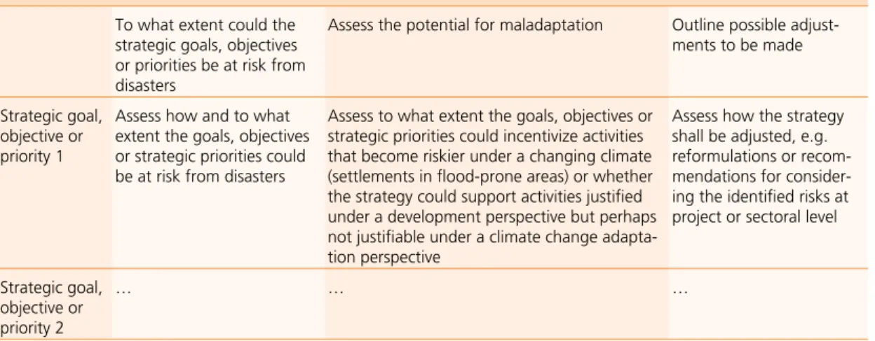
Assess the strategic goals, objectives or priorities
To what extent could the strategic goals, objectives or priorities be at risk from disasters
Assess the potential for maladaptation Outline possible adjust-ments to be made
Strategic goal, objective or priority 1
Assess how and to what extent the goals, objectives or strategic priorities could be at risk from disasters
Assess to what extent the goals, objectives or strategic priorities could incentivize activities that become riskier under a changing climate (settlements in flood-prone areas) or whether the strategy could support activities justified under a development perspective but perhaps not justifiable under a climate change adapta-tion perspective
Assess how the strategy shall be adjusted, e.g. reformulations or recom-mendations for consider-ing the identified risks at project or sectoral level
Strategic goal, objective or priority 2
… … …
MODULE
1
RISK
MODULE
2
MODULE
3
IMPACT
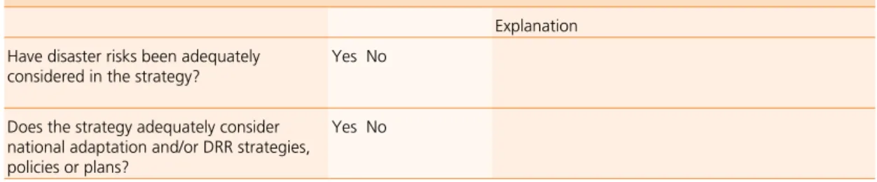
Conclusions of the general assessment of whether the strategy already adequately addresses disaster risks or if it needs eventual adjustments should be reported in narrative format (in the revised strategy). The following Table 5 may help you to report your findings.
Integration of disaster risk considerations in the strategy
Explanation Have disaster risks been adequately
considered in the strategy? Yes No Does the strategy adequately consider
national adaptation and/or DRR strategies, policies or plans?
Yes No
Table 5 Proposed reporting format to analyse whether disaster risk are already considered in the strategy.
Adjust the strategy (if necessary)
Type of adjustments Does the strategy need to be adjusted due
to the identified disaster risks? Yes No If yes, explain what kind of adjustments are needed (e.g. reformulations, recommendations at project level)
Table 6 Proposed reporting format to summarise eventual strategy adjustments.
Recommended links and supporting material
General information on issues related to climate change, environmental degradation and DRR at country level:
Adaptation Atlas (http://adaptationatlas.org/index.cfm) provides useful country specific mapping facilities.
The Climate Change knowledge Portal (http://sdwebx.worldbank.org/climateportal/index.cfm) from the World Bank is a central hub of information, data and reports about climate change around the world. Here you can query, map, compare, chart and summarize key climate and climate-related information.
The WRI Platform EarthTrends (http://www.earthtrends.wri.org/) provides some country specific informa-tion regarding the state of environment.
EM-DAT (http://www.emdat.be/) provides systematic collection and analysis of disaster risk data. The da-tabase provides hands-on country and disaster profiles, disaster lists, reference maps as well as disaster trends.
Reports from IPCC (www.ipcc.ch/publications_and_data/publications_and_data_reports.htm) may also pro-vide useful information on climate change projections.
Munich Re (http://www.munichre.com/de/reinsurance/business/non-life/georisks/natcatservice/default. aspx) comprising some 28’000 data records, NatCatSERVICE is the most comprehensive natural catastrophe loss database in the world. A comprehensive world map is available on NatCatService.
›National Environment Action Plan (NEAP) of the respective country.
›Websites of National Environmental Departments usually provide information on national key issues. national Communications (http://unfccc.int/national_reports/non-annex_i_natcom/items/2979.php) of the respective country (all parties to the UNFCCC) include both the impacts of climate change and the emissions of greenhouse gases within their borders.
national Adaptation Programmes of Actions (NAPAs) (http://unfccc.int/cooperation_support/least_de-veloped_countries_portal/submitted_napas/items/4585.php) are issued by all LDCs that are members to the UNFCCC. They include country profiles with regard to climate change and key adaptation needs.
Preventionweb (http://www.preventionweb.net/english/) serves the information needs of the DRR com-munity, including the development of information exchange tools to facilitate collaboration.
MODULE
1
RISK
MODULE
2
MODULE
3
IMPACT Hyogo Framework for Action progress reports (http://www.preventionweb.net/english/hyogo/progress/
reports/?pid:222&pil:1)
Global Assessment Reports (http://www.preventionweb.net/english/hyogo/gar/) biannual report on global disaster risk reduction.
SAGE (http://www.sage.wisc.edu/mapsdatamodels.html) aims to improve the understanding of the global environment, and how it is being affected by human activities. To achieve this goal they provide maps, computer models and datasets to describe the behaviour of earth’s terrestrial ecosystems, hydrological systems and climate.
Swiss Re (http://www.swissre.com/clients/client_tools/about_catnet.html) provides the CatNet™ functions and data facilitate a professional overview and assessment of natural hazard exposure for any location worldwide. This makes CatNet™ a valuable tool in preparing local, regional and cross-regional risk profiles. The main features of CatNet are natural hazard atlas, country-specific insurance data and links to disaster statistics.
The un ISDR (United Nations International Strategy for Disaster Reduction) website (http://www.unisdr.org/) provides information with regards to DRR such as country information, HFA focal points, national plat-forms, reports on HFA implementation, disasters/events statistics, library on DRR, definition of DRR terms, etc. It also provides a list of national platforms focal points: (http://www.unisdr.org/eng/country-inform/ ci-national-platform.html).
UNDP Climate Change Country Profiles (http://www.geog.ox.ac.uk/research/climate/projects/undp-cp/) provides country reports for over 50 countries containing a set of maps and diagrams demonstrating the observed and projected climate of the country.
The un platform (Division for Sustainable Development) (http://www.un.org/esa/dsd/dsd_aofw_ni/ ni_index.shtml) provides for selected countries profiles regarding key environmental challenges.
World Bank Country Environmental Analysis (CEA) (http://web.worldbank.org/WBSITE/EXTERNAL/ TOPICS/ENVIRONMENT/0,,contentMDK:21239844~pagePK:148956~piPK:216618~theSitePK:244381,00. html) for some countries, environmental analysis has been conducted.
MODULE
1
RISK
MODULE
2
MODULE
3
IMPACT
Module 3 shall be applied when the screening (Module 1) indicates that a Detailed Assessment must be conducted. The methodology for this Detailed Assessment differs from the methodology at the strategic and programmatic level (Module 2) and is specifically developed for SDC projects. Module 3 is divided in two parts. Part A is the Detailed Risk Assessment regarding adaptation (to climate change and to degraded environments) and DRR. Part B is the Detailed Impact Assessment regarding mitigation (climate change and environmental impacts). The process of CEDRIG at project level and the inter-linkages with Module 1 is shown in Figure 5.
Figure 5 Module 1 and 3 at the project level. They follow the PCM of SDC.
Yes
No
No further analysis
MODULE 1: Risk and Impact Screening
Are there significant risks for the activity
or impacts by the activity?
Who
COOF Project team (partners)CEDRIG at project level
Integrating
the results
Project document and credit proposal (chapter 7 and annex 5) Project team (partners) Project team (partners) Project document, credit proposal, log-frame in form of new/ adjusted activities and eventually adjusted objectives
Project team Project document,
credit proposal (annex 5), logframe Entry proposal (for new interventions) or review (of running interventions)
MODULE 3: Detailed Assessment at Project Level
Step 1: Assess risks/impacts
MODULE 3: Detailed Assessment at Project Level
Step 2: Identify adaptation & risk reduction/mitigation options
MODULE 3: Detailed Assessment at Project Level
Step 3: Select adaptation & risk reduction/mitigation options
MODULE 3: Detailed Assessment at Project Level
Step 4: Develop monitoring and evaluation indicators
MODULE 3: Detailed Assessment at
Project Level
MODULE
1
RISK
MODULE
2
MODULE
3
IMPACT This chapter provides step-by-step guidance through the Detailed Risk Assessment process at the project
level. Adaptation to climate change and to degraded environments as well as DRR are jointly addressed in this module.
Step 1: Assessing risks
Aim
Step 1 of the Detailed Risk Assessment builds on the basic screening conducted in Module 1. The aim of this step is to identify the disaster risks emanating from climate change, environmental degrada-tion and/or natural hazards for the project activities. For the equadegrada-tion of disaster risks and related terms please refer to Box 1 in Part I (page 5). It is the most complex and comprehensive step of the Module 3. The following steps 2 to 4 depend significantly on the quality of this step 1.
What to do
A. Collect available data on climate variability and climate change, environmental degrada-tion, tectonic activities and socio-economic information
Compile historical data sets for your area of concern (project area, region, etc.) including temperature, pre-cipitation and extreme events (frequency and severity) as well as environmental degradation patterns and information regarding tectonic activities. Include also local knowledge and qualitative assessments or surveys of local people, especially when local climate data is not available. Based on this, you will have a first overview on issues related to climate variability, climate change, environmental degradation and tectonic activities and will be able to identify relevant hazards.
Not only information on climate change, environmental degradation and natural hazards are important for a risk assessment; the risk from disasters depends very much on the vulnerability of people and systems. Data and information on the socio-economic and environmental conditions as well as the policy environment must therefore to be included in the Detailed Risk Assessment. With this information you will be able to obtain an overview on these conditions and proceed with the next sub-steps.
Instructions:
› Note your findings according to the reporting format provided in Table 7, page 22. Table can be down-loaded from the CCE and DRR Network websites.
› Consult links provided in section “Recommended links and supporting materials”, page 24 as a basis for this step and search for relevant information at national or sub-national level. You will most likely not be able to find data on sound climate projections or scenarios for your project area, or what you find will likely be highly uncertain. However, some links in the section “Recommended links and supporting
materials” will provide a first idea on projected changes at a macro level.
› If you are not sufficiently familiar with the concepts of climate change and adaptation you may also con-sult FAO’s webpage (http://www.webgeo.de/fw_32/) which provides an easily understandable overview on the topics of climate change, adaptation, DRR and implementing community based adaptation. › Furthermore, the IPCC Special Report on Managing the Risks of Extreme Events and Disasters to Advance
Climate Change Adaptation (SREX) provides a good overview on the interrelation between DRR and cli-mate change adaptation: http://ipcc-wg2.gov/SREX/images/uploads/SREX-All_FINAL.pdf
B. Identify the most relevant hazards
Identify and qualitatively assess the most relevant natural hazards being influenced by climate change and environmental degradation in the project area or targeting the project’s objectives or main activities. By in-terpreting hazard information and through local surveys or judgement of local people you will gain insights
A) Detailed Risk Assessment:
Adaptation and DRR
MODULE
1
RISK
MODULE
2
MODULE
3
IMPACT
on the severity and frequency of such events, whether these have changed over time, etc. To identify the most relevant hazards, consult disaster national statistics, surveys on past events, etc. Especially in the case of climate change you will not be able to make a scientific assessment on the future severity and frequency of such events and future (climate) scenarios are generally highly uncertain and not available at sub-national or local level. But gathering information on historical severity and frequency will help obtain a sense on whether these parameters have changed and in general the climate variability has increased or not.
Instructions:
›Include your findings in the format provided in Table 7, page 22. Table can be downloaded from the CCE and DRR Network websites. You’ll find examples of elements of the Risk Assessment in Example 1, page 23.
C. Identify assets most at risk
Whether the identified hazards have an impact on systems and populations depends very much on the present assets and their geographical distribution in the project area. For example floods may only have an impact on humans when their assets are located in the flood-prone area. With this step you will identify the assets most at risk from the identified hazards. You may use the concept of livelihood assets to identify the relevant assets and specify them.
Instructions:
›Include your findings in the format provided in Table 7, page 22. Table can be downloaded from the CCE and DRR Network websites. You’ll find examples of elements of the risk assessment in Example 1, page 23.
D. Identify factors influencing current and future vulnerability/adaptive capacities
Many of the factors which shape vulnerability have nothing to do with climate change, environment degrada-tion and/or tectonic activities. Vulnerability of people or a community depends on several physical, human, social, economic and political factors. They can either positively influence the adaptive/coping capacities of people or on the contrary as a development barrier enhance the vulnerability of people. Gaining an overview of these relevant factors and how they interrelate is highly complex and requires a systemic view across dif-ferent perspectives. This is not only important for assessing risks, but will also help better define appropriate adaptation and risk reduction options (steps 2 and 3). You may best proceed by charting influencing factors on a project area or system and showing their interrelations (e.g. in a mind-map). Focus on key and more direct influencing factors in case you cannot make an in-depth assessment. While concluding this step you will be able to answer the question “What are the relevant factors influencing current and future vulnerability and coping/adaptive capacity?”
Instructions:
›Include your findings in the format provided in Table 7, page 22. Table can be downloaded from the CCE and DRR Network websites. Examples of possible influencing factors are shown in Example 1, page 23.
E. Identify the most important impacts of hazards today and in the future
Impacts are consequences of hazards on natural and human systems. Impacts of hazards differ substantially depending on available assets in a given area. By combining the information on relevant hazards (B), the as-sets most at risk (C) and the influencing factors (D), you will be able to answer the question “What are today and in future the most important impacts of the identified hazards on the assets at risk?”
Instructions:
›Include your finding in the format provided in Table 7, page 22. Table can be downloaded from the CCE and DRR Network websites. You will find examples of possible impacts in Example 1, page 23.
›Consult the data resources outlined in chapter “Recommended links and supporting material”, page 24 especially the link of ci:grasp.
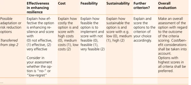
F. Perform a general and qualitative assessment of risks
Risk assessment is a combined assessment of relevant hazards and vulnerabilities. Qualitatively assess the magnitude of disaster risk on the project area/objective or main activity (low, high etc.) and provide a rationale for your risk assessment. You may also make a general assessment of risk at the level of the whole project (and not only at the level of single objectives and activities) in order to have a more holistic risk perspective. You should also make special reference as to whether vulnerable groups such as women and/or children are especially at risk.
MODULE
1
RISK
MODULE
2
MODULE
3
IMPACT Box 1 - opportunities regarding Climate Change
Please note that there can also be potential opportunities for the project, which may arise from climate change. Such positive effects may be e.g. if crop yields are increasing due to warmer temperatures. However, while opportunities may arise in the short-term, they could become risks in the long-term.
Box 1 Opportunities regarding climate change.
Instructions:
› Include your finding in the format provided in Table 7, page 22. Table can be downloaded from the CCE and DRR Network websites. You will find examples of elements of the risk assessment in Example 1, page 23.
Elaboration of the step 1
The risk assessment of step 1 requires a combination of literature research, local surveys and stakeholder consultations. Data collection and literature research (A) will best be performed by one or more people of the project team. For further information on how to collect and analyse climate data please refer to GTZ (2009b). For the collection of climate data (eventually also for data regarding environmental issues) you may also con-sult local research institutions. The information shall be compiled in advance so that it can serve as a basis for broader consultations in subsequent steps. A first basic identification of relevant hazards (B), assets at risk (C) and relevant influencing factors (D) and impacts (E) might also be performed by a small group of people of the project team. However, these preliminary findings should be discussed and amended in a broader stakeholder consultation process (workshop) including project partners and local groups. For the general assessment of risks (F) and the verification of identified factors influencing adaptive capacity (E) consultation and involve-ment of different stakeholders is key. Appreciation of risk is generally not based on scientific and objective criteria but largely depends on political estimations and perceptions of stakeholders.
Entry point and how to make use of the results
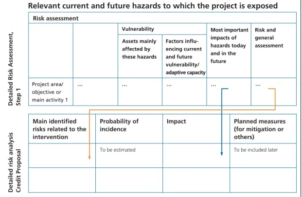
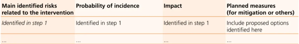
The Detailed Risk Assessment at project level shall be applied as early as possible during the planning phase of a project (see PCM in Figure 5, Part I). The entry point is the logframe or other planning phase results such as outcome mappings. The information gained through this risk assessment (Table 7) should be integrated into the planning documents: (1) into the project document and (2) into chapter 7 (risk management) and Annex 5 (risk analysis) of the credit proposal. The identified risks and impacts shall be transferred to the table in annex 5 as follows: Vulnerability … … … … … Risk and general assessment Most important impacts of hazards today and in the future Risk assessment
Detailed Risk Assessment, Step 1
Detailed risk analysis Credit Proposal
To be included later To be estimated Impact Probability of incidence Main identified
risks related to the intervention
Project area/ objective or main activity 1
Relevant current and future hazards to which the project is exposed
Assets mainly affected by these hazards Factors influ-encing current and future vulnerability/ adaptive capacity Planned measures (for mitigation or others)
MODULE
1
RISK
MODULE
2
MODULE
3
IMPACT
Please note that in order to complete the table, you will need to add the probability of incidence and the planned measures. While the latter will result from step 3, the former has to be estimated during risk as-sessment.
Results of step 1 and tables to complete
›Relevant information on hazards influenced by climate change and natural environmental degradation and socio-economic data and information is collected.
›Relevant current and future hazards are identified and vulnerabilities are qualitatively assessed. ›Overall risks are assessed.
The result of this step may be summarised in the format of the following Table 7:
Risk assessment
Relevant current and future hazards to which the project is exposed
Vulnerability Most important impacts of haz-ards today and in the future
Risk and general assessment Assets mainly
affected by these hazards
Factors influenc-ing current and future vulnerabil-ity and/or adap-tive capacity
Project area/ objective or main activity 1
List most rel-evant hazards and roughly assess their frequency and severity today and in the future
List and specify relevant livelihood assets
List relevant influ-encing factors and mention in what direction they in-fluence (enhancing or limiting adaptive capacity/ coping capacity) Mention relevant impacts. Provide an overall assessment of current and future risks. Include a qualita-tive assessment of the magnitude of the risks Project area/ objective or main activity 2 … … … … …
Project in general … … … … Overall assessment
of risks for the whole project Table 7 Proposed reporting format for step 1.
Where appropriate and according to the thoroughness of this assessment the table shall be complemented by explanations and interpretations in narrative format.
MODULE
1
RISK
MODULE
2
MODULE
3
IMPACT
Recommended links and supporting material
EXAMPLE 1 - ELEMEnTS FoR THE RISk ASSESSMEnT Project area/ objective, main activity Relevant current and future hazards to which the project is exposed
Vulnerability Most important im-pacts of hazards today and in the future
Risk and general assess-ment
Assets mainly affected
by these hazards Factors influencing current and future vulnerability/ adaptive capacity › Rice produc-tion › Animal husbandry › Urban sanitation and water supply; Watershed management › Forest man-agement › Transport in-frastructure › Hydropower production › Event hazards: droughts, heat waves, floods, storms, landslides, debris flows, rock-, snow-, ice-avalanche; tectonic hazards such as earthquake, volcanic activ-ity, tsunami › Gradual shift hazards: sea level rise, climate zone shifts, saliniza-tion of areas › Hazards due to environ-mental deg-radation: air/ water and soil pollution, land degradation, deforestation, desertification, wild land fires, loss of biodi-versity, ozone depletion
› Human capital: skills, knowledge, health and ability to work › Social capital: social
resources, including informal networks, membership of formal-ised groups and rela-tionships of trust that facilitate co-operation › Natural capital: natural
resources such as land, soil, water and forests › Physical capital: basic
infrastructure (roads, water & sanitation, schools, ICT) and pro-ducer goods (tools and equipment)
› Financial capital: finan-cial resources including savings, credit, insur-ance and income from employment, trade and remittances › Political capital: power
and capacity to influ-ence political decision-making, formal and informal participation, access to political processes, (access to vote), freedom and capacity to collectively organise
› Enhancing factors: Access to and control over natural, human, social, physical and financial resources (refer to assets), e.g. high level of educa-tion, good quality infrastructure, reliable water source, diversi-fied income sources; user and property rights, decentralised organisation of public services, enabling policy environment, availability of an infor-mation and communi-cation system/channels and appropriate ICTs › Limiting factors:
De-velopment barriers in general, e.g.: poverty, critical health condi-tions, low education, prevalence of highly vulnerable groups, high unemployment, degradation of vegeta-tion, scarcity of natural resources, human pres-sure on ecosystems, conflict, etc.
› Water: Reduced fresh-water ability, decrease in water quality & availability
› Ecosystems: exceeded resilience of ecosys-tems, extinction of species, loss of habitats › Food: falling crop and
timber productivity, decreasing fishery resources, soil erosion, desertification › Coasts: damage from
floods and storms, coastal erosion › Health: impacts on
hu-man health, increased frequency/severity of disease and pest outbreaks, increased health impacts due to air/soil/water pollution › Settlement and society:
Migration, increasing risk of conflicts, ero-sion of institutions › Victims (deaths),
injured, displaced, af-fected people › Livelihood loss: such
as harvests, financial (income) or physical capital (e.g. infrastruc-ture)
Example 1 Elements of risk assessment in step1. The table shows possible examples for the respective part of step1.
EXAMPLE 2 - RISk ASSESSMEnT Project area/ objective, main activity Relevant current and future hazards to which the project is exposed
Vulnerability Most important impacts of haz-ards today and in the future
Risk and general assessment
Assets mainly affected by these hazards Factors influenc-ing current and future vulner-ability/ adaptive capacity
Rice
produc-tion Droughts are already occur-ring today and are projected to become even more severe in future. Gradual temper-ature increase will most likely continue.
Natural and financial capital
Low level of edu-cation of the com-munity in general and prevalence of highly vulnerable minority groups.
Rice fertility and harvest will decrease with an increase in temperature and with more severe droughts.
Severe risks to the communities in the project area, as they are highly dependent on rice production. They will face a severe loss of income and food shortages due to decrease in harvest.
The risk is assessed as high also due to limited adaptive capacity.
MODULE
1
RISK
MODULE
2
MODULE
3
IMPACT
General information on issues related to climate change, environmental degradation and DRR at a country level:
Adaptation Atlas (http://adaptationatlas.org/index.cfm) provides useful country specific mapping facilities.
ci:grasp (http://cigrasp.pik-potsdam.de/) performs as a climate information service and provides sound knowledge on current and projected climate stimuli, climate impacts and adaptation options at the na-tional, sub-national and regional level. It can help to identify impact chains of different hazards.
Climate Change knowledge Portal (http://sdwebx.worldbank.org/climateportal/index.cfm?page=why_ climate_change) includes country profiles regarding vulnerability, risk reduction and adaptation to climate change.
The Conservancy Climate Wizard (http://www.climatewizard.org/) provides historic climate data as well as downscaled projections.
The UN platform (Division for Sustainable Development) (http://www.un.org/esa/dsd/dsd_aofw_ni/ni_ index.shtml) provides for selected countries profiles regarding key environmental challenges.
The WRI Platform EarthTrends (http://www.earthtrends.wri.org/) provides some country specific informa-tion regarding the state of environment.
The EMDAT database (http://www.emdat.be/) provides global disaster statistics, including country-level disaster profiles.
General information on climate change can be found in the reports IPCC (www.ipcc.ch/publications_and_ data/publications_and_data_reports.htm) which may include important information on climate change pro-jections.
national Communications (http://unfccc.int/national_reports/non-annex_i_natcom/items/2979.php) of the respective country (all parties to the UNFCCC) include both the impacts of climate change and the emissions of greenhouse gases within their borders.
national Adaptation Programmes of Actions (NAPAs) (http://unfccc.int/cooperation_support/least_de-veloped_countries_portal/submitted_napas/items/4585.php) are available for all LDCs that are members to the UNFCCC. Including country profiles with regard to climate change and key adaptation needs.
national Environment Action Plan (nEAP) of the respective country.
Preventionweb (http://www.preventionweb.net/english/hyogo/progress/reports/?pid:222&pil:1
)
contains progress report regarding the Hyogo Framework for Action.Preventionweb (http://www.preventionweb.net/english/hyogo/gar/) contains the biannual Global Assess-ment Report on Disaster Risk Reduction.
SAGE (http://www.sage.wisc.edu/mapsdatamodels.html) aims to improve the understanding of the global environment, and how it is being affected by human activities. To achieve this goal, they provide maps, computer models and datasets to describe the behaviour of Earth’s terrestrial ecosystems, hydrological systems, and climate.
Swiss Re (http://www.swissre.com/clients/client_tools/about_catnet.html) provides the CatNet™ functions and data facilitate a professional overview and assessment of natural hazard exposure for any location worldwide. This makes CatNet™ a valuable tool in preparing local, regional and cross-regional risk profiles. The main features of CatNet are natural hazard atlas, country-specific insurance data and links to disaster statistics.
The un ISDR (United Nations International Strategy for Disaster Reduction) website (http://www.unisdr.org/) provides information with regard to DRR such as country information, HFA focal points, national platforms, reports on HFA implementation, disasters/events statistics, library on DRR, etc. It also provides a list of na-tional platforms focal points: (http://www.unisdr.org/eng/country-inform/ci-nana-tional-platform.html). UNDP Climate Change Country Profiles (http://www.geog.ox.ac.uk/research/climate/projects/undp-cp/) provides country reports for over 50 countries containing a set of maps and diagrams demonstrating the observed and projected climate of the country.
MODULE
1
RISK
MODULE
2
MODULE
3
IMPACT World Bank Country Environmental Analysis (CEA) (http://web.worldbank.org/WBSITE/EXTERNAL/
TOPICS/ENVIRONMENT/0,,contentMDK:21239844~pagePK:148956~piPK:216618~theSitePK:244381,00. html) contains environmental analysis for some countries.
Further readings and information:
For a better understanding about the concepts of climate change and adaptation at the community level, the FAo’s webpage (http://www.webgeo.de/fw_32/) on climate change and adaptation provides a simple overview.
If you are interested more deeply in how climate change information is being researched and analysed, you may consult the GTZ (2009b) (http://www.gtz.de/en/themen/28938.htm) which provides guidance on how climate change information can be gathered, which experts shall be consulted during this process and how data from climate models need to be interpreted.
For information about “ICTs and Disaster Management” you can consult http://www.bcoalliance.org/ climate-change or http://www.itu.int/ITU-T/climatechange or http://www.apdip.net/publications/iespprim-ers/eprimer-dm.pdf.
IPCC Data Visualization (http://www.ipcc-data.org/maps/.) as part of the Data Distribution Centre of the IPCC provides climate, socio-economic and environmental data, both from the past and also in scenarios projected into the future. Scatter plots from: http://www.ipcc-data.org/sres/scatter_plots/scatterplots_ home.html.
The Tearfund 2009b and 2009c (http://tilz.tearfund.org/webdocs/Tilz/Topics/Environmental%20Sustain-ability/CEDRA%20D5.pdf and http://tilz.tearfund.org/webdocs/Tilz/Topics/Environmental%20Sustainabil-ity/EA_C9465_web.pdf) provide a hands-on manual on integrating climate change, environmental and disaster related risk into development cooperation.
The platform WeAdapt (http://weadapt.org/) provides knowledge sharing opportunities for the climate ad-aptation community including helpful links, tools and documents on adad-aptation topics; including also tools such as the Climate Change Explorer (http://weadapt.org/knowledge-base/using-climate-information/ the-climate-change-explorer-tool). This tool is a desktop client that provides an interface to download, manage and visualize downscaled model output. It provides users with an analytical foundation from which to explore the climate variables relevant to their particular adaptation decisions.