O R I G I N A L P A P E R
P. A. Ziegler Æ P. De`zes
Evolution of the lithosphere in the area of the Rhine Rift System
Received: 23 October 2003 / Accepted: 1 December 2004 / Published online: 31 March 2005 Ó Springer-Verlag 2005
Abstract The Rhine Rift System (RRS) forms part of the European Cenozoic Rift System (ECRIS) and tran-sects the Variscan Orogen, Permo-Carboniferous troughs and Late Permian to Mesozoic thermal sag basins. Crustal and lithospheric thicknesses range in the RRS area between 24–36 km and 50–120 km, respec-tively. We discuss processes controlling the transforma-tion of the orogenically destabilised Variscan lithosphere into an end-Mesozoic stabilised cratonic lithosphere, as well as its renewed destabilisation during the Cenozoic development of ECRIS. By end-Westphalian times, the major sutures of the Variscan Orogen were associ-ated with 45–60 km deep crustal roots. During the Stephanian-Early Permian, regional exhumation of the Variscides was controlled by their wrench deformation, detachment of subducted lithospheric slabs, astheno-spheric upwelling and thermal thinning of the mantle-lithosphere. By late Early Permian times, when asthenospheric temperatures returned to ambient levels, lithospheric thicknesses ranged between 40 km and 80 km, whilst the thickness of the crust was reduced to 28–35 km in response to its regional erosional and local tectonic unroofing and the interaction of mantle-derived melts with its basal parts. Re-equilibration of the litho-sphere-asthenosphere system governed the subsidence of Late Permian-Mesozoic thermal sag basins that covered much of the RRS area. By end-Cretaceous times, lithospheric thicknesses had increased to 100–120 km. Paleocene mantle plumes caused renewed thermal weakening of the lithosphere. Starting in the late Eocene, ECRIS evolved in the Pyrenean and Alpine foreland by passive rifting under a collision-related north-directed compressional stress field. Following end-Oligocene consolidation of the Pyrenees, west- and northwest-directed stresses originating in the Alps
controlled further development of ECRIS. The RRS remained active until the Present, whilst the southern branch of ECRIS aborted in the early Miocene. Exten-sional strain across ECRIS amounts to some 7 km. Plume-related thermal thinning of the lithosphere underlies uplift of the Rhenish Massif and Massif Cen-tral. Lithospheric folding controlled uplift of the Vosges-Black Forest Arch.
Keywords Rhine Graben Æ Rifting Æ Lithosphere Æ Stress Æ Magmatism
Introduction
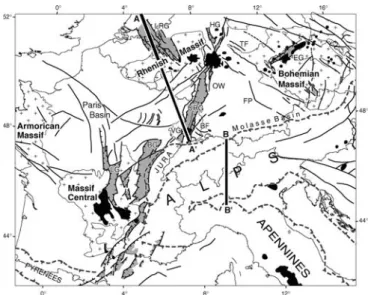
The Rhine Rift System (RRS), comprising the north-ward trending Upper Rhine and Hessian (Wetterau, Leine) grabens and the northwest striking Roer Valley (Lower Rhine) graben, forms the northern branch of the intracontinental European Cenozoic Rift System (ECRIS) that extends over a distance of some 1,100 km from the shores of the North Sea into the Western Mediterranean (Fig.1; Ziegler 1994). The southern branch of ECRIS includes the grabens of the Massif Central (Limagne, Forez, Roanne), the Bresse Graben and the grabens of the Rhoˆne Valley (Valence, Ale`s, Manosque, Camarque). The Burgundy transfer zone links the northern and southern segments of ECRIS. A secondary transfer zone links the northern ends of the Limagne and Upper Rhine Grabens via the eastern parts of the Paris Basin. The Eger (Ohre) Graben of the Bohemian Massif forms an integral part of ECRIS. The Rhoˆne Valley grabens find their southern extension in the Gulf of Lions-Valencia rift system, whose develop-ment was governed by fundadevelop-mentally different dynamic processes than those controlling the evolution of ECRIS.
In the ECRIS area the depth to Moho varies between 24 km and 36 km (Fig.2; Prodehl et al.1995; De`zes and Ziegler 2002). The thickness of the thermal lithosphere
P. A. Ziegler (&) Æ P. De`zes
Department of Geosciences, Geological-Palaeontological Institute, University of Basel, Bernoullistr. 32, 4056 Basel, Switzerland E-mail: [email protected]
Tel.: +41-61-4215535 Fax: +41-61-4215535
decreases from about 100 km to 120 km under the Bohemian Massif and along the southern end of the Upper Rhine Graben to 50–60 km beneath the Rhenish Massif and Massif Central and apparently increase to some 120 km or more in the Western Netherlands and beneath the Paris Basin (Babushka and Plomerova1992;
Prodehl et al. 1995; Sobolev et al. 1997; Goes et al. 2000a, b). In Western and Central Europe the upper asthenosphere displays anomalously low P- and S-wave velocities (Zielhuis and Nolet1994; Goes et al.2000a,b). Tomographic images suggest that low velocity structures rising up from the deep mantle feed smaller upper-mantle plumes, the most important of which well up beneath the Rhenish Massif and the Massif Central (Granet et al.1995; Goes et al.1999; Ritter et al.2001). ECRIS transects the essentially SW–NE striking French and German parts of the Variscan Orogen which were, and partly still are, covered by Late Permian and Mesozoic sediments. During the evolution of ECRIS, these sediments were disrupted in conjunction with up-lift of the Rhenish Massif, the Vosges-Black Forest Arch, the Massif Central and the Bohemian Massif in which parts of the Variscan Orogen are exposed, thus providing insight into its architecture. This offers a un-ique opportunity to evaluate the post-Variscan evolution of the lithosphere, particularly as only the southernmost parts of the ECRIS were affected by Mesozoic rifting (Ziegler and De`zes2005).
The present crustal and lithospheric configuration of the ECRIS area bears no relationship to the major structural units of the Variscan Orogen but shows affinities with the graben systems and arches that developed during Cenozoic times (Ansorge et al. 1992; Mengel 1992; Ziegler and De`zes 2005). Yet, develop-ment of the Variscan Orogen did involve major crustal shortening and subduction of substantial amounts of supra-crustal rocks, continental and oceanic crust and mantle-lithosphere (Ziegler et al. 1995, 2004). By anal-ogy with the Alps (Schmid et al. 1996; Stampfli et al. 1998), the Variscan Orogen was probably characterised at its end-Westphalian consolidation by a significantly thickened crust and lithosphere. Therefore, its orogeni-cally destabilised lithosphere must have re-equilibrated with the asthenosphere in post-Variscan times to the end that regional crustal and lithospheric thicknesses of about 28–35 km and 100–120 km, respectively, were achieved, as evident in areas that were not affected by Cenozoic rifting.
During the last 300 Ma, the megatectonic setting of the ECRIS area underwent repeated changes. Following the end-Westphalian consolidation of the Variscan Orogen, Stephanian-Early Permian wrench faulting and associated intrusive and extrusive magmatic activity accompanied its collapse. During Late Permian to end-Cretaceous times, large parts of the ECRIS area were gradually incorporated into intracratonic sedimentary basins that presumably subsided in response to thermal contraction of the lithosphere during its re-equilibration with the asthenosphere. By contrast, Mesozoic rifting, culminating in the Mid-Jurassic opening of the Alpine Tethys, mid-Cretaceous opening of the Bay of Biscay-Valais Basin (Stampfli et al.1998,2001) and early Eocene opening of the Arctic-North Atlantic (Ziegler 1988), interrupted these cooling trends and caused a renewed destabilisation of the asthenosphere–lithosphere
Fig. 2 Depth map of Moho discontinuity, contour interval 2 km (after De`zes and Ziegler2002), with superimposed Cenozoic fault systems. Interrupted barbed line: Alpine deformation front Fig. 1 Location map of ECRIS in the Alpine foreland, showing Cenozoic fault systems (black lines), rift-related sedimentary basins (light grey), Variscan massifs (cross pattern) and Cenozoic volcanic fields (black). Interrupted barbed line: Alpine deformation front. BF Black Forest, BG Bresse Graben, EG Eger (Ore) Graben, FP Franconian Platform; HG Hessian grabens, LG Limagne Graben, LRG Lower Rhine (Roer Valley) Graben, URG Upper Rhine Graben, OW Odenwald; VG Vosges. Thick lines A-A’ and B-B’: location of transects given in Figs.4and9
system of shelves flanking these domains (Helvetic, Dauphinois and Atlantic shelves; Ziegler and Stampfli 2001). During the latest Cretaceous and Palaeocene, the entire ECRIS area was affected by an important pulse of intraplate compression that can be related to early phases of the Alpine and Pyrenean orogenies (Ziegler 1990; Ziegler et al.1995,1998,2002). At the same time melilite dykes were injected into the Massif Central, Vosges-Black Forest and Bohemian Massif. This reflects low-degree partial melting of the lithospheric thermal boundary layer at depths of 60–100 km in response to an increase in the temperature of the asthenosphere (Wilson et al. 1995; Ziegler et al. 1995). From late Eocene times onwards, ECRIS developed in the foreland of the evolving Alpine and Pyrenean orogens, with crustal extension and con-tinued plume activity causing further destabilisation of the lithosphere–asthenosphere system. Under the present northwest-directed stress field the RRS is tectonically still active whereas the grabens of the Massif Central and the Rhoˆne Valley became inactive during the early Miocene (De`zes et al.2004; Merle and Michon2001; Schumacher 2002; Se`ranne1999; Ziegler1990,1994).
In this contribution we summarise the results of our studies on processes that controlled the transformation of the orogenically destabilised Variscan lithosphere into cratonic lithosphere, with special emphasis on its con-figuration prior to the onset of Cenozoic rifting and its response to intraplate stresses and plume activity during the development of ECRIS. A model is presented for the Permo-Carboniferous to end-Mesozoic evolution of the Variscan lithosphere in the RRS area that is based on quantitative and forward modelled subsidence analyses of selected wells (Ziegler et al. 2004). The Cenozoic evolution of the RRS and the Alps is reviewed on the basis of a retro-deformed lithospheric transect that ex-tends from the Central Alps to Amsterdam and sup-porting palaeotectonic maps (De`zes et al. 2004). In our analyses we applied the time scale of Menning et al. (2000) and Menning (1995) for the Carboniferous and Permo-Triassic, respectively, the scale of Gradstein and Ogg (1996) for the remainder of the Mesozoic, and the scale of Berggren et al. (1995) for the Cenozoic.
Variscan Orogen
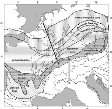
The RRS transects the suture between the external Rheno-Hercynian and the more internal Saxo-Thurin-gian zone, as well as the sutures between the Saxo-Thuringian and Bohemian (Moldanubian s.l.) and the Bohemian and Moldanubian (s.s.) zones (Fig.3). The triple junction of the Upper Rhine, Roer and Hes-sian grabens is superimposed on the south-dipping Rheno-Hercynian/Saxo-Thuringian suture. The Upper Rhine Graben transects the south-dipping Saxo-Thu-ringian/Bohemian suture in the northern parts of the Vosges-Black Forest Arch (Lalaye-Lubin and Baden-Baden zone), and the north-dipping Bohemian/
Moldanubnian (s.s.) suture in the southern parts of the Black Forest (Badenweiler-Lenzkirch zone) (Eisbacher et al. 1989; Franke 2000; Hegner et al. 2001). To the southwest, this suture links up with the Mt. du Lyonnais suture that is transected by the Bresse Graben and the grabens of the Massif Central (Lardeaux et al.2001).
At the end-Westphalian termination of the Variscan orogeny, the crustal and lithospheric configuration of the future RRS area was heterogeneous. Whereas the Rheno-Hercynian zone was underlain by continen-tal foreland lithosphere, the Saxo-Thuringian and Moldanubian (s.l.) zones were characterised by an orogenically thickened lithosphere that was thermally destabilised by widespread granitic magmatism. In the internal zones of the Variscan Orogen, crustal thick-nesses probably ranged between 45 km and 60 km with crustal roots marking the Rheno-Hercynian/Saxo-Thu-ringian, Saxo-Thuringian/Bohemian and Bohemian/ Moldanubnian sutures. In the area of the Mid-German Crystalline Rise, a major south-dipping continental litho-spheric slab extended from the Variscan foreland beneath the Rheno-Hercynian/Saxo-Thuringian suture. A north-dipping, partly oceanic subduction slab was probably associated with the Bohemian/Moldanubnian suture, whereas the south-dipping Saxo-Thuringian/Bohemian slab had already been detached from the lithosphere dur-ing mid-Visean times (Fig.4a; Ziegler et al.2004).
Stephanian-Early Permian disruption of the Variscan Orogen
During the Stephanian and Early Permian, dextral translation of Gondwana and Laurussia controlled the
Fig. 3 Variscan tectonic framework with superimposed ECRIS fault pattern (after Ziegler et al.2004)
evolution of the Appalachian-Mauretanides and Scyth-ian orogens and the wrench-induced collapse of the European Variscan Orogen. Transtensional and trans-pressional wrench deformation of the Variscan Orogen and its northern foreland, as well as associated mag-matic activity, abated at the transition to the Late Permian, in tandem with the consolidation of the Appalachian Orogen (Arthaud and Matte1977; Ziegler 1989,1990; Coward1993; Marx et al.1995; Ziegler and Stampfli2001; Ziegler and De`zes 2005).
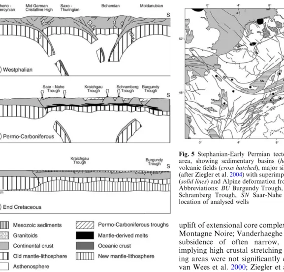
Stephanian-Early Permian wrench-induced disrup-tion of the rheologically weak Variscan Orogen was accompanied by its regional exhumation, widespread extrusive and intrusive magmatic activity, peaking during the Early Permian, and the subsidence of a multi-directional array of intramontane transtensional trap-door and pull-apart basins, containing continental clastics (Fig.5). Basins developing during this time-span underwent a complex, polyphase structural evolution, including a late phase of transpressional deformation controlling their partial inversion. Although Stepha-nian-Early Permian wrench deformation locally induced
uplift of extensional core complexes (e.g. Massif Central, Montagne Noire; Vanderhaeghe and Teyssier2001) and subsidence of often narrow, fault-bounded basins, implying high crustal stretching factors, large interven-ing areas were not significantly extended (Ziegler 1990; van Wees et al.2000; Ziegler et al.2004).
Whilst exhumation of the Variscan internides had commenced already during the main phases of the Variscan orogeny, regional uplift of the entire orogen and its foreland began only after crustal shortening had ceased at the end-Westphalian. Stephanian-Early Permian erosional and tectonic exhumation of the Variscan Orogen, in many areas to formerly mid-crustal levels (Burg et al. 1994; Vigneresse 1999; Seyferth and Henk 2000), can be attributed to such processes as wrench deformation, heating of crustal roots involving eclogite to granulite transformation (Bousquet et al. 1997; Le Pichon et al. 1997), detachment of subducted slabs, upwelling of the asthenosphere and related ther-mal attenuation and partial delamination of the mantle-lithosphere, as well as to magmatic and thermal inflation of the remnant lithosphere (Fig.4b).
The widespread Stephanian-Early Permian (305– 285 Ma) alkaline intrusive and extrusive magmatism of the Variscan domain and its foreland is mantle-derived and locally shows evidence of crustal contamination (Bonin 1990; Bonin et al. 1993; Neumann et al. 1995; Marx et al. 1995; Benek et al. 1996; Cortesogno et al. 1998; Breitkreuz and Kennedy 1999; Neumann et al. 2004). Melt generation by partial melting of the upper-most asthenosphere and the lithospheric thermal boundary layer was probably triggered by a rise in the potential temperature of the asthenosphere and by its
Fig. 5 Stephanian-Early Permian tectonic framework of ECRIS area, showing sedimentary basins (horizontally hatched), major volcanic fields (cross hatched), major sills (black) and fault systems (after Ziegler et al.2004) with superimposed Variscan tectonic units (solid lines) and Alpine deformation front (interrupted barbed line). Abbreviations: BU Burgundy Trough, KT Kraichgau Trough, SB Schramberg Trough, SN Saar-Nahe Trough. Black dots show location of analysed wells
Fig. 4 Conceptual model for Late Palaeozoic and Mesozoic evolution of the lithosphere in the RRS area along transect A-A’(not to scale) (after Ziegler et al.2004). For location see Fig.3
localised transtensional decompression. Wrench-induced detachment of subducted lithospheric slabs presumably caused a reorganisation of the mantle convection system and upwelling of the asthenosphere (Ziegler et al.2004). Mantle-derived basic melts, which had ascended to the base of the crust and underplated it, induced crustal anatexis and the intrusion of fractionally crystallised granitic to granodioritic-tonalitic melts into the crust, with crustal-scale fractures providing conduits for the ascent of magmas to the surface (Cortesogno et al.1998; Breitkreuz and Kennedy1999).
The interaction of mantle-derived basic melts with the felsic lower crust, as well as retrograde metamor-phism of the eclogitised crustal roots of the Variscan Orogen (Bousquet et al. 1997), apparently contributed to a re-equilibration of the Moho at depths of 28–35 km and locally less. By Mid-Permian times, some 30 Ma after consolidation of the Variscan orogen, its crustal roots had disappeared.
During the Stephanian and Early Permian, a system of essentially ENE-WSW trending transtensional intra-montane basins developed in the area of the Upper Rhine Graben, whereas NW striking fracture systems transected the Rhenish Massif (Fig.5). Development of these basins, containing thick continental clastics and volcanics, involved reactivation of the Variscan struc-tural grain, predominantly by dextral shear. The Saar-Nahe Trough is superimposed on the Rheno-Hercynian/ Saxo-Thuringian terrane boundary and partly on the Saxo-Thuringian/Bohemian suture. The Kraichgau Trough broadly reflects reactivation of the Saxo-Thu-ringian/Bohemian Lalaye-Lubin-Baden-Baden suture, whereas the Schramberg and Burgundy troughs are associated with the Bohemian/Moldanubnian Len-zkirch-Badenweiler-Mt. du Lyonnais suture. Subsidence of these basins was coupled with uplift and erosion of intervening highs. At the same time, a system of NNE-SSW trending Variscan shear zones was sinistrally reactivated, partly outlining the Upper Rhine and Hes-sian grabens (Boigk and Scho¨neich1970; Eisbacher et al. 1989; Weber1995a; Schumacher2002).
In the area of the Roer and Hessian grabens, post-orogenic exhumation of the Rheno-Hercynian thrust belt, prior to the transgression of Late Permian sedi-ments, increased southward from some 2–3 km along its northern margin to as much as 10 km adjacent to the Saar-Nahe Basin (Littke et al. 2000; Oncken et al. 2000). Subsidence of this partly inverted basin, which contains up to 5.6 km of Permo-Carboniferous clastics accounting for a stretching factor of >1.36, involved transtensional reactivation of the Rheno-Hercynian/ Saxo-Thuringian and Saxo-Thuringian/Bohemian sutures. Extrusion of voluminous basalts and rhyolites in the Saar-Nahe Basin, dated at 296–293 Ma, reflects profound destabilisation of its lithospheric system (Henk 1993; Stollhofen and Stanistreet 1994; Korsch and Scha¨fer 1995; Weber1995b; von Seckendorff et al. 2004). In the area of the Mid-German Crystalline Rise post-kinematic granitic to dioritic magmatism increased
during the Stephanian-Early Permian (Scha¨fer et al. 2000; Thomson and Zeh 2000; Zeh and Bra¨tz2004).
Strong Stephanian transtensional reactivation of the NE trending German segment of the Rheno-Hercynian/ Saxo-Thuringian suture apparently caused detachment of the subducted continental Rheno-Hercynian litho-spheric slab beneath the Mid-German Crystalline Rise; this slab was introduced into the mantle during late Visean to Westphalian times (after mid-Visean detach-ment of its oceanic part; Ziegler et al.2004). Upwelling of the asthenosphere into the space formerly occupied by this slab, triggered partial melting of the asthenosphere and the remnant mantle-lithosphere, ascent of melts to the base of the crust and anatexis of lower crustal rocks (model of Davies and von Blanckenburg1995). In con-junction with an ensuing reorganisation of mantle flow patterns, a not-very-active mantle plume apparently welled up to the base of the lithosphere in the area of the eastern parts of the future Southern Permian Basin, causing thermal attenuation of the mantle-lithosphere and magmatic destabilisation of the crust-mantle boundary (van Wees et al.2000; Ziegler et al.2004). A branch of the Southern Permian Basin upwelling system apparently extended from northeast Germany via the Hessian Depression into the area of the Saar-Nahe Trough. This concept is supported by the presence of a distinct middle and lower crustal positive magnetic anomaly that extends from northeast Germany into the area of the Saar-Nahe Trough (Hahn and Wonik2002); this anomaly probably reflects Permo-Carboniferous permeation of the crust by mantle-derived basic melts. On the other hand, the Rhenish Massif was apparently little affected by magmatic processes but was subjected to regional uplift and erosion, reflecting unflexing of the foreland lithosphere, mainly in response to detachment of the subducted Rheno-Hercynian slab, and perhaps also to retrograde metamorphism of its eclogitised parts. In the area of the Upper Rhine Graben, Stephanian-Early Permian development of a system of ENE–WSW trending intramontane basins (Boigk and Scho¨neich 1970; Philippe et al. 1996), overlying high-grade meta-morphic rocks, reflects transtensional reactivation of the orogenic fabric of the Variscan Internides. Subsidence of these basins and exhumation of intervening highs in response to transtensional lithospheric deformation was accompanied by the intrusion of abundant rhyolite and granite porphyry dikes and the extrusion of Permian rhyolites, reflecting the ascent of mantle-derived partial melts to the base of the crust, lower crustal anatexis and destabilisation of the Moho (Eisbacher et al.1989; von Raumer 1998; Prijac et al. 2000). Similarly, the wide-spread occurrence of a reflection-seismically laminated 10–15 km thick lower crust is mainly attributed to Permo-Carboniferous injection of mantle-derived basic sills (Ziegler et al.2004). In addition, truncation of the crustal orogenic fabric by the Moho (Meissner and Bortfeld1990) speaks for contemporaneous magmatic destabilisation of the crust-mantle boundary. This reflects a major thermal surge that was presumably triggered by detachment of the
subducted north-dipping Moldanubian slab in the area of the Lenzkirch-Badenweiler-Mt. du Lyonnais suture (Lardeaux et al.2001; Ziegler et al.2004). By end-Early Permian times, the crust of the Variscan Internides had been regionally reduced to 28–35 km in response to its tectonic and erosional unroofing and magmatic desta-bilisation of the Moho discontinuity.
In the internal Variscan zones, no mantle reflectors related to subducted crustal material (Ziegler et al. 1998), could be detected despite dedicated surveys (Meissner and Rabbel 1999). This may be an effect of delamination and/or strong thermal thinning of the mantle-lithosphere during the inferred Stephanian-Early Permian thermal surge (Fig. 4b). This is compatible with circumstantial evidence provided by the sedimentary record of Late Permian and Mesozoic basins which subsided in response to re-equilibration of the litho-sphere–asthenosphere system (see below).
Late Permian and Mesozoic thermal subsidence and rifting
By late Early Permian times (±280 Ma), magmatic activity had abated and thermal anomalies introduced during the Permo-Carboniferous began to decay, con-trolling regional thermal subsidence of the lithosphere. In combination with progressive erosional degradation of the remnant topography and cyclically rising sea levels (Haq et al. 1988), increasingly larger areas sub-sided below the erosional base-level and were incorpo-rated into a new system of intracratonic basins.
However, in areas bordering the future Tethys and Atlantic domains, thermal subsidence of the lithosphere was overprinted and partly interrupted by the Triassic onset of a new rifting cycle (Ziegler and Stampfli2001). At the same time a multi-directional rift system devel-oped in Western and Central Europe, comprising the North Sea rift, the Danish-Polish Trough and the gra-ben systems of the Atlantic shelves. Stress fields con-trolling the evolution of this rift system changed repeatedly in conjunction with the late Middle Jurassic opening of the Alpine Tethys, the Mid-Cretaceous opening of the Valais Trough and the Late Cretaceous concentration of crustal extension on the Arctic–North Atlantic rift (Ziegler 1990; Ziegler et al.2001).
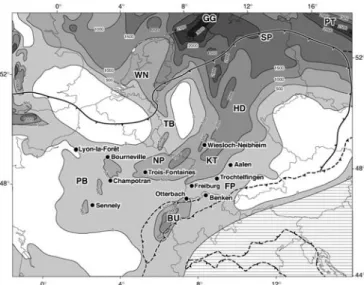
Although the RRS area was only marginally affected by Mesozoic rifting, minor diffused crustal stretching probably contributed to the subsidence of the Kraich-gau, Nancy-Pirmasens, Burgundy and Trier Basins (Fig.6). Triassic and Jurassic reactivation of Permo-Carboniferous faults, controlling subtle lateral facies and thickness changes, is also evident in the Paris Basin (Bessereau et al. 1995; Goggin et al.1997) and the area of the Burgundy Trough (Wetzel et al.2003). Mesozoic crustal extension played, however, a more important role in the area of the future Roer Graben that lies in the prolongation of the West Netherlands Basin (Zijerveld et al. 1992), as well as in the area of the Rhoˆne Valley
grabens that formed part of shelves flanking the Alpine Tethys and Pyrenean-Valais Ocean (Stampfli 1993; Stampfli et al.2001).
Subsidence analyses on selected wells from the Upper Rhine Graben, the Paris Basin and the Franconian Platform, applying the backstripping method of Sclater and Christie (1980), show that in the RRS area re-equilibration of the lithosphere with the asthenosphere commenced during the late Early Permian (±280 Ma) and persisted throughout the Mesozoic (Prijac et al. 2000; van Wees et al.2000; Ziegler et al.2004). However, detailed tectonic subsidence curves show that temporary and generally local Mesozoic subsidence accelerations are superimposed on the long-term thermal subsidence trends (Fig.7). These reflect either tensional reactivation of Permo-Carboniferous fault systems or compressional deflection of the lithosphere (Cloetingh1988) under far-field rift- and wrench-related stress far-fields. Temporal and spatial variations in these subsidence accelerations are attributed to differences in the orientation of pre-existing crustal discontinuities and changes in the prevailing stress field. Nevertheless, overall subsidence trends clearly reflect re-equilibration of the lithosphere– asthenosphere system trough time.
Tectonic subsidence modelling
In an attempt to define the configuration of the litho-sphere at the end of the Early Permian, the tectonic subsidence curves were compared with a theoretical thermal decay curve, applying an automated numerical
Fig. 6 Isopach map of restored Triassic series, contour interval 500 m, showing location of analysed wells and Variscan (solid barbed line) and Alpine (interrupted barbed line) deformation fronts (after Ziegler et al. 2004). White: areas of non-deposition; horizontally hatched: not mapped area. Abbreviations: BU Burgundy Trough, FP Franconian Platform, GG Glu¨ckstadt Graben, HD Hessian Depression, KT Kraichgau Trough, NP Nancy-Pirmasens Trough, PB Paris Basin, PT Polish Trough, SP Southern Permian Basin, TB Trier Basin, WN West Netherlands Basin
forward/backward modelling technique which auto-matically finds the best-fit stretching parameters for the observed subsidence data (van Wees et al. 1996,2000). This modelling technique incorporates lithospheric stretching assumptions (d=crustal, b=mantle-litho-spheric stretching factor), a lithosphere represented by a plate with constant temperature boundary conditions (fixed basal temperature), crustal heat production effects and conductivity variations, and allows for finite and multiple stretching phases. Differential stretching of the crust and mantle-lithosphere can be applied to simulate thermal attenuation of the latter (van Wees et al.1992, 1996, 2000; van Wees and Stephenson 1995). Input parameters for forward/backward modelling of ob-served subsidence curves include the pre-rift crustal thickness, the post-rift equilibrated lithospheric thick-ness, and for each stretching phase its timing, duration and extension mode (uniform d=b, McKenzie 1978; two-layered d<b, Royden and Keen 1980). The mod-elled uplift and subsidence history of the lithosphere is then compared to the observed tectonic subsidence curve. In iterative steps input parameters are changed until a good fit is obtained between the observed and
modelled curves. This way, best-fit stretching parameters are determined that give a measure of the initial Permo-Carboniferous thermal perturbation of the lithosphere, as well as of subsequent tensional events which inter-fered with the re-equilibration of the lithosphere/ asthenosphere system (Ziegler et al.2004).
Modelling of the lithosphere evolution in the RRS area assumes that after the Permo-Carboniferous ther-mal surge (300–280 Ma) the temperature of the asthenosphere returned rapidly to ambient levels (1,300°C), at least until the end-Cretaceous renewed flare-up of plume activity. Therefore, we assumed for equilibrated thermal lithosphere (Artemieva and Mooney 2001) thicknesses of 100–120 km, which are typical for areas that were not affected by Cenozoic rifting (Babushka and Plomerova1992). As most of the analysed wells are locate outside or on the margins of Permo-Carboniferous troughs (Fig. 5), initial crustal thicknesses of 30 to 35 km were considered as repre-sentative at the end of Permo-Carboniferous magmatic thinning and erosional unroofing of the crust.
The Permo-Carboniferous tectono-magmatic cycle (300–280 Ma) was modelled with differential crustal and mantle-lithospheric extension, allowing ß factors, reflecting delamination and/or thermal thinning of the mantle-lithospheric, to attain significantly greater values than d factors. The temporary Mesozoic subsidence accelerations were modelled with uniform lithospheric extension (d=b). All modelled subsidence curves (Fig.8; Ziegler et al. 2004) show an initial uplift between 300 Ma and 280 Ma, the amplitude of which gives a measure of lithospheric thinning during the Stephanian-Early Permian. From 280 Ma onward, the modelled curves reflect thermal subsidence of the lithosphere, the surface of which remained above the erosional base-level until the curves dip below the zero line. From this point onward, the modelled curves are constrained by the tectonic subsidence curves derived from the sedimentary record of the respective wells (black squares in Fig.7).
Good fits between observed and modelled tectonic subsidence curves were obtained, assuming initial crustal thicknesses of 30–35 km, final lithospheric thicknesses of 100–120 km, and a Permo-Carboniferous ‘‘stretching’’ phase spanning 300–280 Ma, involving decoupled crus-tal extension and mantle-lithospheric attenuation. This assumption is compatible with the concept that Permo-Carboniferous crustal extension played only locally a significant role. Indeed, large Permo-Carboniferous troughs, which occur on the Massif Central, the Bohe-mian Massif and the Franconian Platform do not coincide with Late Permian and Mesozoic depocentres, whereas no major Permo-Carboniferous sedimentary troughs underlay the Southern Permian Basin and Paris Basin depocentres (Ziegler 1990). This suggests that during the Permo-Carboniferous tectono-magmatic cy-cle uniform and/or depth-dependent mechanical stretching of the lithosphere was, on a regional scale, only a contributing and not the dominant mechanism of crustal and mantle-lithospheric thinning. By contrast, 0 250 500 750 1000 0 250 500 750 1000 1000 750 500 250 0 50 100 150 200 250 300 0 50 100 150 200 250 300 age (Ma) age (Ma) air-loaded tectonic subsidence curve modelled subsidence curve A B uplift (m) depth (m) subsidence (m)
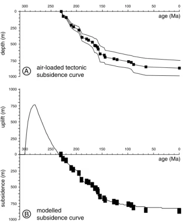
Fig. 7 a Air-loaded tectonic subsidence curve and b modelled subsidence curve for well Bourneville, Paris Basin (after Ziegler et al.2004). For locations see Fig.6. Black squares: control points derived from penetrated sedimentary sequence. The positive part of the modelled subsidence curve reflects uplift of the crust in response to thermal thinning and/or delamination of the mantle-lithosphere; its negative part reflects thermal subsidence of the crust during re-equilibration of the lithosphere/asthenosphere system
Permo-Carboniferous lithospheric stretching may have played a somewhat more important role in the Late Permian and Mesozoic evolution of the Hessian
Depression, Nancy-Pirmasens and Burgundy Trough. However, the axes of these basins are only partly aligned with Permo-Carboniferous troughs and partly even cross cut them (compare Figs.5, 6).
In accordance with the concept that, after the Permo-Carboniferous thermal surge, the temperature of the asthenosphere had returned to ambient levels by late Early Permian times, the modelled tectonic subsidence curves demonstrate that from then onward the evolution of the lithosphere in the RRS area was governed by the long-term decay of thermal anomalies. Moreover, modelled curves suggest that by late Early Permian times the thermal thickness of the mantle-lithosphere had been reduced to between 9 km and 48 km and that crustal thicknesses ranged between 27 km and 34 km (Table1, Fig.4b; Ziegler et al.2004).
Calculated ß factors are subject to large variations and reflect heterogeneous mantle-lithosphere thinning that was generally more intense in areas that evolved into Mesozoic depocentres than in areas marginal to them. However, in areas which remained positive fea-tures through much of Mesozoic times, such as the Bohemian and Armorican Massifs, the mantle-litho-sphere was apparently not significantly thinned during the Permo-Carboniferous, retained a thickness of 50– 90 km and an orogen (subduction)-related anisotropy (Babushka and Plomerova2001; Judenherc et al.2002). Best-fits between observed and modelled subsidence curves were obtained when the thickness of the thermal lithosphere was set at 100 or 120 km at its end-Mesozoic equilibration with the asthenosphere (Fig.4c). For the Upper Rhine Graben and the Franconian Platform best-fits were obtained with a 100-km thick lithosphere, whereas for the Paris Basin best-fits were achieved with a lithosphere thickness of 120 km. Whilst a 100 km lith-osphere thickness is compatible with the Palaeocene plume-related segregation depth of olivine-melilitic partial melts in the Vosges, Black Forest and Bohemian Massif (Wilson et al.1995), no explanation can be given for the apparently greater lithosphere thickness beneath the Paris Basin.
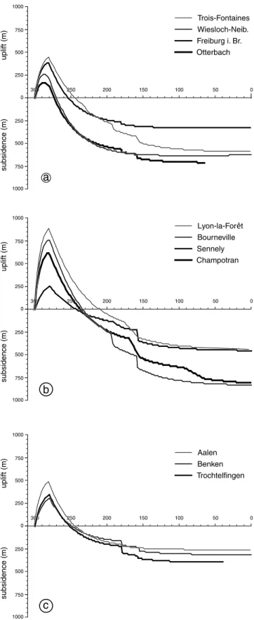
Although ß factors given in Table1must be consid-ered as rough approximations only, substantial Permo-Carboniferous thinning of the mantle-lithosphere provided the principal driving mechanism for the sub-sidence of Late Permian and Mesozoic thermal sag basins in the RRS area. On a regional scale, modelled Permo-Carboniferous crustal extension was relatively low, with automated modelling yielding d factors of 1.04–1.13 and crustal thicknesses close to the actual ones (assuming initial crustal thicknesses of 30–35 km). The minor, intra-Mesozoic subsidence accelerations, which overprint the long-term thermal subsidence curves, were successfully modelled by uniform lithospheric extension, yielding cumulative d=b values in the 1.01–1.07 range. As corresponding extensional faulting is generally poorly documented, stress-induced deflections of the lithosphere (Cloetingh 1988) may have contributed to some of these temporary subsidence accelerations. 0 50 100 150 200 250 300 uplift (m) subsidence (m) Aalen Benken Trochtelfingen c 0 250 500 750 1000 1000 750 500 250 0 50 100 150 200 250 300 uplift (m) subsidence (m) Lyon-la-For t Bourneville Sennely Champotran a 0 250 500 750 1000 1000 750 500 250 0 50 100 150 200 250 300 0 250 500 750 1000 1000 750 500 250 uplift (m) subsidence (m) Trois-Fontaines Wiesloch-Neib. Freiburg i. Br. Otterbach b
Fig. 8 Modelled subsidence curves for a Upper Rhine Graben and Lorraine area, b Paris Basin and c Franconian platform (after Ziegler et al.2004). For location of wells see Fig.6
Paleocene to Mid-Eocene ECRIS pre-rift stage
During the latest Cretaceous and Paleocene, subsidence of Mesozoic sedimentary basins that had developed in the RRS area was interrupted and the entire area was uplifted and subjected to erosion. This is attributed to the build-up of intraplate compressional stresses that were projected from the Alpine and Pyrenean orogens into their northern foreland. However, continued sub-sidence and sedimentation characterised the Paris Basin and parts of the North Sea and North German Basins (Ziegler 1990).
By Paleocene times, southward subduction of the Piemont (Alpine Tethys) Ocean beneath the Austro-Alpine orogenic wedge was apparently completed, resulting in collision of the latter with the continental Brianc¸onnais Terrane, which since the Cenomanian (90 Ma) formed part of the European plate (Fig. 9a; Stampfli et al.1998,2001; Schmid et al.2004). Owing to subduction resistance of the Brianc¸onnais Terrane, compressional stresses were transmitted through it and the Valais Ocean into the northward adjacent Helvetic Shelf and the domain of the future RRS. These stresses induced broad-scale warping and uplift of the European lithosphere, causing the development of a regional ero-sional unconformity, and, by reactivation of pre-existing faults, inversion of the West-Netherlands and Saar-Nahe basins. The most distal Paleocene inversion structures are located in the central North Sea, some 1,700 km to the northwest of the contemporaneous Alpine collision front (Ziegler1990; Ziegler et al.1998,2002).
Similarly, in the foreland of the Western Alps and Pyrenees, the Dauphinois Shelf and the Massif Central were uplifted and subjected to erosion during the Paleocene in response to the build-up of compressional intraplate stresses originating at the Pyrenean collision zone (Verge´s and Garcı´a-Senez2001) and sinistral shear
motions between the Brianc¸onnais Terrane and the Iberian micro-continent during their separation. Related far-field stresses are held responsible for early inversion movements in the Paris Basin and Channel area (Ziegler 1988, 1990; Ziegler et al.2002; De`zes et al.2004).
Paleocene compressional deformation of the Alpine and Pyrenean forelands was accompanied by the injec-tion of olivine-nephelinite and olivine-melilite dykes in the area of the Massif Central, the Vosges-Black Forest, the Rhenish Massif and the Bohemian Massif, reflecting very low degree partial melting of the lithospheric thermal boundary layer and an asthenospheric source at depths of 60–100 (Wilson et al.1995; Ziegler et al.1995; Adamovic and Coubal1999; Ulrych et al.1999; Michon and Merle 2001; Keller et al. 2002). This suggests that the temperature of the asthenosphere had increased in these areas during the Paleocene, presumably in re-sponse to activation of a system of not-very-energetic mantle plumes (Granet et al. 1995; Sobolev et al.1997; Ritter et al.2001; Ziegler et al.2004). Significantly, this distinctly pre-rift magmatic activity in the ECRIS area essentially coincided with the activation of the NE Atlantic (Hoernle et al. 1995) and Iceland plumes (Ziegler1990; Bijwaard and Spakman1999). Thus, it is likely that development of the broad thermal anomaly, that is now evident at the base of the West and Central European lithosphere (Zielhuis and Nolet 1994; Goes et al. 2000a, b), commenced during the Paleocene, causing thermal weakening of the lithosphere and thus rendering it prone to deformation (Ziegler et al. 1995). During the early and middle Eocene, scattered pre-rift volcanic activity continued in the Upper Rhine Graben area (Keller et al.2002), on the Rhenish Massif (Lippolt 1983) and on the Bohemian Massif (Ulrych et al.1999). During the early Eocene, northward convergence of the Alpine orogenic wedge with its European foreland accelerated (Schmid and Kissling 2000). With this,
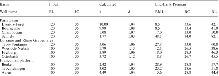
Table 1 Input parameters and modelling results for Permo-Carboniferous thermal destabilisation of the lithosphere
Basin Input Calculated End-Early Permian
Well name EL IC ß d RML RC RL Paris Basin Lyon-la-Foret 120 35 10.00 1.04 8.5 33.6 42.1 Bourneville 120 35 9.99 1.08 8.5 33.4 41.9 Champotran 120 35 5.08 1.07 17.0 33.0 50.0 Sennely 120 35 1.77 1.03 48.1 34.0 82.1
Lorraine and Rhine Graben area
Trois-Fontaines 120 35 3.06 1.06 27.8 33.0 60.8 Wiesloch-Neibsh 100 30 5.79 1.13 12.1 26.5 38.6 Freiburg 100 30 3.89 1.06 18.0 28.3 46.3 Otterbach 100 30 3.72 1.12 18.8 26.7 45.5 Franconian platform Benken 100 30 2.42 1.04 28.9 28.8 57.7 Trochtelfingen 100 30 3.02 1.05 23.2 28.6 51.8 Aalen 100 30 4.49 1.04 15.6 28.8 44.4
EL equilibrated lithosphere thickness in km; IC initial crustal thickness in km; ß mantle-lithospheric attenuation factor; d crustal stretching factor; RML remnant mantle-lithosphere thickness in km; RC remnant crustal thickness in km; RL remnant lithosphere thickness in km
imbrication of the upper crust and sedimentary cover of the Brianc¸onnais Terrane and the Valais Ocean and subduction of their lower crust and mantle lithosphere commenced (Fig.9b; Schmid et al.1996; Stampfli et al. 1998). Sediment subduction accounted for mechanical decoupling of the Alpine orogenic wedge and the Euro-pean lithosphere, as evidenced by the end-Paleocene relaxation of compressional intraplate stresses in the Al-pine foreland (Ziegler1990; Ziegler et al.2002). Slab- and thrust-loaded flexural subsidence of the Helvetic and Dauphinois shelves began during the middle Eocene (Burkhard and Sommaruga 1998; Lickorish and Ford 1998; Sissingh2001). In the Pyrenees, continued early and middle Eocene crustal shortening (Verge´s and Garcı´a-Senez 2001) was accompanied by the main deformation phase of the Languedoc-Provenc¸al thrust belt (Fig.10a; Roure and Colletta 1996).
During the middle Eocene, isolated, shallow depres-sions developed in the area of the Upper Rhine, Bresse and Valence grabens and on the Massif Central in which, generally thin fluvio-lacustrine sediments were deposited; these are separated by a hiatus from the late Eocene earliest syn-rift deposits (Sissingh 1998, 2001, 2003). It is uncertain whether development of these depressions can be attributed to an initial rifting phase (shallow lithospheric necking level, Kooi et al. 1992), which was controlled by the gradual build-up of north-directed compressional foreland stresses (Fig. 10a).
Late Eocene initial rifting stage of ECRIS
By late Eocene times, the lithosphere of the Brianc¸on-nais and the Valais Ocean had been subducted and subduction of the Helvetic Shelf commenced whilst crustal slices of the Brianc¸onnais and Valais Ocean were incorporated into the Alpine orogenic wedge (Fig.9c). Continued thrust- and slab-loaded subsidence of the Helvetic and Dauphinois shelves caused rapid widening of the flexural foreland basin (Schmid et al. 1996; Stampfli et al. 1998; Burkhard and Sommaruga 1998; Lickorish and Ford 1998; De`zes et al.2004).
Increasing subduction resistance of the European lithosphere was coupled with imbrication of the basement of the distal Helvetic Shelf (Subpenninic Adula nappe: Schmid et al. 1996) and the build-up of northward-di-rected intraplate compressional stresses in the Alpine foreland. In the ECRIS area these stresses interfered constructively with northward-directed compressional stresses emanating from the Pyrenean collision zone (Bergerat 1987; Ziegler 1994; Se´ranne 1999; Merle and Michon2001). This stress field controlled the late Eocene early rifting phases of the Upper Rhine Graben during which Late Variscan and Permo-Carboniferous crustal discontinuities were transtensionally reactivated (Sissingh 1998; Schumacher2002). Similarly, late Eocene activation of the Massif Central, Bresse and Valence grabens in-volved tensional reactivation of Permo-Carboniferous fracture systems (Michon and Merle2001; Sissingh2001).
By contrast, contemporaneous development of the Lower Rhoˆne Valley grabens involved transtensional reactiva-tion of the Provenc¸al thrust belt and of underlying Mesozoic extensional fault systems (Roure and Colletta 1996; Sanchis and Se´ranne2000).
Volcanic activity associated with the initial rifting stage of the Upper Rhine Graben (Lippolt1983; Keller et al. 2002) indicates gradual assertion of the Rhenish mantle plume (Ritter et al. 2001). Whereas during the late Eocene volcanic activity increased on the Bohemian Massif (Ulrych et al.1999), there is no evidence for time equivalent volcanism on the Massif Central (Michon and Merle2001).
At the Eocene-Oligocene transition far-field com-pressional stresses governed the second inversion phase of the West-Netherlands Basin (Ziegler 1990; de Lugt et al.2003).
Oligocene-early Miocene main rifting stage of ECRIS
At the Eocene-Oligocene transition, the subducted lithospheric slab of the Central and Eastern Alps was detached from the foreland lithosphere within the Helvetic margin (Fig.9d; Davies and von Blanckenburg 1995; Schmid et al. 1996). Subsequently, the Alpine orogenic wedge continued to converge with the Euro-pean foreland, but now in a northwest direction (Schmid and Kissling2000). Development of the Apulian mantle back-stop accounted for strong collisional coupling be-tween the Central Alpine orogenic wedge and its northern and southern forelands, as evidenced by back-folding of the entire orogen and further imbrication of the European foreland crust (e.g. Gotthard Massif; Schmid et al.1996). On the other hand, the subducted lithospheric slab of the Western Alps remained attached to the European foreland. Continued Oligocene crustal shortening caused back folding of the West Alpine orogenic wedge and emplacement of nappes derived from the Valais Ocean, Brianc¸onnais Terrane and Pie-mont Ocean on the Dauphinois Shelf (Lickorish and Ford1998; Fu¨genschuh and Schmid2003; Bucher et al. 2003). By end Oligocene times, the Alpine deformation front was located some 100 km to the south of the Upper Rhine Graben and about 100 km to the east of the Bresse Graben.
North-directed compressional stresses, projected into the European foreland from the Alpine and Pyrenean collision zones, controlled the Oligocene main exten-sional phase of ECRIS (Fig.10b; Bergerat 1987). Dur-ing the Rupelian, riftDur-ing propagated from the Upper Rhine Graben northward into the Hessian and Roer Valley grabens (Ziegler1990; Schumacher2002; Michon et al.2003). Similarly, the grabens of the Massif Central and Rhoˆne Valley subsided rapidly during the Oligocene and coalesced. This was coupled with further sinistral motions along the Burgundy transfer zone that links the Limagne and Bresse Grabens with the Upper Rhine Graben (Bergerat1977; Ziegler1994; Merle and Michon
2001) and the activation of the more diffuse eastern Paris Basin transfer zone that links the Limagne Graben with the northern end of the Upper Rhine Graben (Coulon 1992). Intermittent Oligocene marine connections between the Alpine foreland basin and the North German Basin via the grabens of ECRIS indicate that by this time the Rhenish Massif and the Massif Central were still located close to sea level (Ziegler 1990,1994; Michon and Merle 2001; Merle and Michon2001; Sis-singh 1998,2001,2003). However, increasing volcanism in the area of the Rhine-Roer-Hessian graben triple junction, and late Oligocene gradual uplift of the Rhenish Massif probably reflect increased activity of the Rhenish mantle plume and related thermal thinning of the mantle-lithosphere (Lippolt1983; Jung 1999; Ritter et al.2001). By contrast, on the Massif Central, scattered volcanic activity resumed only during the late Oligocene (Michon and Merle2001). During the early and middle Oligocene, the Bohemian Massif was affected by a major phase of volcanism that essentially preceded subsidence of the NE striking Eger Graben (Malkovsky 1987; Ad-amovic and Coubal 1999; Ulrych et al.1999).
During the late Rupelian and Chattian, the grabens of the lower Rhoˆne Valley propagated southward across the eastern, by now inactive, parts of the Pyrenean Orogen into the Gulf of Lions and into coastal Spain (Fig.10b). The evolving Gulf of Lions-Valencia Trough rift system remained active until crustal separation was achieved during the late Aquitanian (21.5 Ma) and the oceanic Provenc¸al-Ligurian Basin began to open. Development of this rift system was driven by back-arc extension related to eastward roll back of the subducted Alpine Tethys slab that dipped beneath Corsica-Sardinia and the Balearic islands (Se´ranne1999; Roca2001).
Early and middle Oligocene north-directed compres-sional stresses emanating from the active central Pyre-nean Orogen (Verge´s and Garcı´a-Senez 2001) played a dominant role in controlling the main extensional stage of ECRIS. These ‘‘Pyrenean’’ stresses interfered con-structively in the RRS area with north-directed com-pressional stresses originating in the Central Alps (Fig.10b; Bergerat 1987; Schumacher 2002). By con-trast, subsidence of the northeast striking Eger Graben, that contains 300–400 m thick late Oligocene-early Miocene sediments, commenced only towards the end of its main magmatic pulse, presumably in response to the collapse of a thermal dome (Malkovsky1987; Adamovic and Coubal 1999). During the late Oligocene, litho-spheric shortening compensating for Africa–Europe convergence, was gradually transferred from the Pyre-nean collision zone to the Corsica-Sardinia-Balearic arc-trench system. With this, ‘‘Pyrenean’’ intraplate compressional stresses gradually relaxed in the Euro-pean foreland, whilst roll-back of the Alpine Tethys slab controlled the late Oligocene-early Miocene develop-ment of the Gulf of Lions-Valencia Trough rift system (Se´ranne 1999; Roca 2001). Conversely, we question whether slab-pull forces exerted by the southeast- to east-dipping West-Alpine subduction system
contrib-uted to the Oligocene subsidence of the Massif Central, Bresse and Valence grabens, which subparallel the Western Alps, as postulated by Stampfli et al. (1998), Merle and Michon (2001) and Michon et al. (2003). In this respect it should be kept in mind that the late Oligocene-early Miocene pulse of basin inversion affecting the Western Shelves, the Channel and Paris Basin (Fig.10b) can be attributed to the build up of collision-related, northwest-directed compressional stresses in the foreland of the Western Alps (Ziegler 1990; Ziegler et al. 1995, 1998, 2002) and minor west-ward rotation of France in response to crustal extension across ECRIS (De`zes et al.2004)
Miocene response of ECRIS to Alpine compression
Imbrication of the external massifs of the Western and Central Alps commenced during the Burdigalian (Fig.9e; Schmid et al. 1996; Fu¨genschuh and Schmid 2003). Progressive uplift of these massifs was accompa-nied by the propagation of thin-skinned thrusts into the Helvetic and Dauphinois shelves and ultimately into the domain of the Jura Mountains (Schmid et al. 1996; Burkhard and Sommaruga 1998; Lickorish and Ford 1998; Philippe et al. 1996, 1998). From the Burdigalian onward, increased collisional coupling of the Alpine Orogen with its northern and western forelands had clear repercussions on the evolution of ECRIS (Fig.10c).
During the Miocene, the Roer Valley Graben and the northern parts of the Upper Rhine Graben continued to subside under a northwest-directed compressional stress field (Schumacher2002; Michon et al.2003), whereas the Rhenish Massif, including the Hessian grabens, was gradually uplifted and became the site of increased volcanic activity (Lippolt 1983; Jung 1999; Sissingh 2003). This is attributed to progressive thermal thinning of the mantle-lithosphere above the increasingly active Rhenish plume (Ritter et al.2001).
Uplift of the Vosges-Black Forest Arch commenced during the Burdigalian (Fig.10c; Laubscher1992). In a N–S direction and at the top-basement level, the amplitude of this arch is about 2.5 km and its wave-length some 200 km with a steeper southern and a gentler northern flank. At the level of the Moho, this arch forms the culmination of broadly southwest-northeast trending anticlinal feature, which extends from the Massif Central via the Burgundy transfer zone towards the Bohemian Massif (Fig.2; De`zes and Ziegler 2002). As the Vosges-Black Forest Arch is not associ-ated with mantle-lithospheric thinning (Achauer and Masson 2002), its development is attributed to
Fig. 9 Conceptual model for Cenozoic evolution of the lithosphere in the RRS area along transect A-B’ (after De`zes et al.2004). For location see Fig.1
lithospheric folding. End-Aquitanian (20.5 Ma) trans-pressional reactivation of pre-existing basement discon-tinuities at the southern end of the Upper Rhine Graben (Laubscher2003) reflects the build-up of compressional stresses at crustal levels, heralding uplift of the
Vosges-Black Forest Arch. Uplift of this arch was accompanied by volcanic activity within and outside the Upper Rhine Graben, spanning 18–7 Ma (Jung 1999; Keller et al. 2002), reflecting low-degree decompressional partial melting of the asthenosphere and the lithospheric
ther-Fig. 10 Palaeotectonic sketch maps of ECRIS area. a middle Eocene, b late Oligocene, c end early Miocene, d Pliocene-Quaternary (modified after De`zes et al.2004). Dark grey orogens; light grey areas of non-deposition; white sedimentary basins; stippled oceanic basins; starsvolcanism; arrows maximum horizontal compressional stress direction (after: Bergerat1987; Ble`s and Gros1991; Schumacher2002; Andeweg2002); thick dashed line axis of lithospheric fold. Abbreviations: AG Algerian Basin, AP Apulia, AT Alpine Tethys, BB Bay of Biscay, CS Celtic Sea, GV Gulf of Lions-Valencia rift, LP Languedoc-Provenc¸al fold belt, PB Paris Basin, PL Provenc¸al-Ligurian Basin,
mal boundary layer. Development of the Vosges-Black Forest Arch commenced around 18 Ma, continued during the late Miocene to early Pliocene thin-skinned folding phase of the Jura Mountains (10–4 Ma; Laub-scher1986,1992; Philippe et al.1996; Becker2000), and was coupled with uplift of the southern parts of the Upper Rhine Graben, causing deep truncation of its Oligocene-early Miocene syn-rift sediments (Roll 1979; Villemin et al. 1986; Sissingh 1998; Schumacher 2002; De`zes et al.2004). Whereas Miocene and early Pliocene crustal extension across the Upper Rhine Graben con-trolled continued subsidence of its northern parts, lithospheric folding-related uplift over-compensated for the extensional subsidence of its southern parts.
Marine connections between the Upper Rhine Gra-ben, the Molasse and North Sea basins were severed during the Burdigalian and end-Langhian, respectively (Sissingh2003), owing to lithospheric folding in the area of the Burgundy transfer zone and the Vosges-Black Forest and thermal doming of the Rhenish Massif. From the Serravallian onward, the erosional base-level in the Upper Rhine Graben was controlled by the ele-vation of tectonic sills separating it from adjacent basins. Miocene NW–SE extension across the Eger Graben intensified after 18 Ma, when sediment accumulation in this basin ended (Adamovic and Coubal1999) and uplift of the northern parts of the Bohemian Massif com-menced, presumably in response to lithospheric folding. In the Bresse Graben, an intra-Burdigalian (±18 Ma) erosional unconformity, that is overstepped by thin Serravallian and younger series (Se´ranne 1999; Sissingh 1998, 2001), can be attributed to lithospheric folding along the Burgundy transfer zone. Uplift and northward tilting of the Massif Central commenced during the Burdigalian, controlling the development of its north-directed drainage system. With this, its grabens ceased to subside (Merle et al.1998; Michon and Merle 2001; Sissingh 2001). On the Massif Central, volcanic activity increased during the middle Miocene (14 Ma), shifted to its southern parts and reached a first peak during the late Miocene (9–6 Ma) (Michon and Merle 2001). Plume-related thinning of the mantle-lithosphere presumably played a dominant role in the gradual uplift of this massif (Sobolev et al. 1997; Michon and Merle 2001), with lithospheric folding playing a subordinate role.
The grabens of the Lower Rhoˆne Valley became inactive with the late Aquitanian (21.5 Ma) onset of sea-floor spreading in the Provenc¸al-Ligurian Basin that ended during the late Burdigalian (16.5 Ma; Se´ranne 1999; Roca2001). The Manosque and Ale`s grabens were partly inverted during the Miocene (Roure and Colletta 1996; Sanchis and Se´ranne2000), reflecting the build-up of a westerly-directed, collision-related compressional stress field (Fig. 10c; Ble`s and Gros 1991). Similarly, further inversion of the Paris, Channel and Western Approaches basins during the late Miocene testifies to the build-up of compressional stresses in the distal foreland of the Western Alps (Ziegler 1990).
Neotectonic deformation of the RRS
In the Western and Central Alps, crustal shortening persisted during the Pliocene and Quaternary, as evi-denced by continued uplift of their external massifs (Jouanne et al.1998; Fu¨genschuh and Schmid2003) and further compressional deformation of the Jura Moun-tains (Fig.9e; Philippe et al. 1996; Giamboni, et al. 2003) and the Dauphinois (Martinod et al. 1996; Lickorish and Ford 1998). Neotectonic activity within the Alps and their foreland is documented by seismicity (Giglia et al. 1996; Deichmann et al. 2000; Schmid and Kissling2000) and by geodetic data that indicate pres-ent-day shortening rates of 2–5 mm/y for the Dauphi-nois and French Jura Mountains (Jouanne et al. 1995; Martinod et al. 1996). From about 4 Ma onward, compressional deformation of the Jura Mountains was no longer exclusively thin-skinned but involved also the basement, as indicated by intra-crustal earthquakes (Roure et al. 1994; Philippe et al. 1996; Jouanne et al. 1998; Becker 2000). During the Pliocene, frontal ele-ments of the Jura fold-and-thrust belt encroached on the margins of the Upper Rhine and the Bresse grabens.
Under the present north- to northwest-directed compressional stress regime (Mu¨ller et al.1997) the Roer Valley graben is extending nearly orthogonally, whereas the Upper Rhine and lower Rhoˆne Valley grabens are subjected to sinistral transtension (Fig.10d; Ahorner 1975; Giglia et al. 1996; Hinzen 2003). Pliocene and Quaternary extensional and transtensional subsidence of the Roer Valley and Upper Rhine grabens, respectively, is documented by the fault-controlled thickness of their sedimentary fill, the occurrence of active faults and earthquake activity (Ahorner1983; Zijerveld et al.1992; Plenefisch and Bonjer1997; Schumacher2002; Michon et al.2003). By contrast, there is no evidence for further subsidence of the Massif Central grabens (Michon and Merle2001), whereas the Bresse Graben was tensionally reactivated during the Pliocene (Sissingh 1998; De`zes et al. 2004). In the Rhoˆne Valley minor Pliocene-Qua-ternary normal faulting has been recorded (Ble`s and Gros1991).
During the late Pliocene (2.9 Ma) the palaeo-Aare river, which from 4.2 Ma onwards had flowed westward along the Jura thrust front into the Bresse Graben (Sundgau gravels), was deflected into the Upper Rhine Graben (Mu¨ller et al.2002; Giamboni et al.2003). This may be attributed to a resumption of tensional subsi-dence of the southern parts of the Upper Rhine Graben, combined with decreasing uplift rates of the Vosges-Black Forest Arch. Geodetic data show for the Vosges-Black Forest a pattern of slow uplift of horst- and slow sub-sidence of graben-structures at rates rarely exceeding 0.25 mm/y (Mu¨ller et al. 2002). In the area of the Rhenish Massif, volcanic activity shifted during the Pliocene and Quaternary towards the Eifel area (Lippolt 1983). Geomorphologic data indicate that uplift of the Rhenish Massif accelerated around 0.8 Ma, amounting
since then up to 250 m (Garcia-Castellanos et al.2000; Meyer and Stets 2002). In the Eifel area, recent uplift rates of up to 1.2 mm/y have been recorded (Ma¨lzer et al. 1983). Processes contributing to this uplift pre-sumably include the thermal load of the Eifel plume (radius 50 km; Ritter et al. 2001; Garcia-Castellanos et al. 2000), thermal thinning of the mantle-lithosphere, and possibly also crustal scale folding and reactivation of Variscan thrust faults under the prevailing NW-di-rected compressional stress field (Ahorner1983; Hinzen 2003). Beneath the volcanic fields of the Rhenish Massif the lithosphere has been thermally thinned to 50–55 km (Prodehl et al.1995).
High-resolution reflection-seismic data indicate that the northern parts of the Upper Rhine Graben subsided continuously during Miocene to Quaternary times. South of the city of Speyer, late Miocene and Pliocene fluvial and lacustrine series progressively overstep the intra-Burdigalian unconformity, that had developed in conjunction with uplift of the Vosges-Black Forest Arch, so that sedimentation in the southern parts of the Upper Rhine Graben resumed only during the late Pliocene and Quaternary (Roll 1979). Syn-sedimentary extensional faults and local positive flower-structures (Strasbourg transfer zone) were active during the Plio-Quaternary subsidence of the Upper Rhine Graben (see also Illies et al.1981).
During the late Pliocene (2.9–1.65 Ma) the sediment load of the Rhine River was effectively trapped in the Upper Rhine Graben, indicating that sediment supply was in balance with the development of accommodation space by extensional graben subsidence and tectonic controls on the erosional base-level. During the late Pliocene, the Upper Rhine Graben was drained north-ward by a low energy river (Bingen-Koblenz Rhine) that linked up with the higher energy Moselle River which crossed the Rhenish Massif and debouched into the Roer Valley Graben where the Kieseloolite sands and gravels were deposited (Brunnacker and Boenigk 1983; Klett et al. 2002; Sissingh 2003). At the end of the Pli-ocene (1.65 Ma) the first arrival of Alpine detrital components in the Roer Valley Graben (Boenigk2002; Heumann and Litt2002) indicates that sediment supply to the Upper Rhine Graben apparently exceeded its subsidence rates. During the Quaternary, the erosional base-level of the continuously subsiding Upper Rhine Graben was controlled by the uplift-rate of the Rhenish Massif and the incision-rate of the Rhine River. The present erosional base-level of the Upper Rhine Graben is located 80 m above MSL at the entrance to the Rhine canyon.
Neotectonic activity in the southern parts of the Upper Rhine Graben is documented by the deformation of the Pliocene Sundgau gravels and Pleistocene terraces along the Jura Mountains thrust front (Giamboni et al. 2004), by faults extending through Quaternary deposits of the graben fill, and by the seismicity of the area. Earthquake focal mechanisms indicate strike-slip to compressional deformation of the upper crust, whereas
the lower crust is subjected to extension (Plenefisch and Bonjer 1997; Deichmann et al. 2000). Transpressional deformation of the upper crust is attributed to collision-related stresses transmitted from the Alps above an incipient mid-crustal detachment level. Lower crustal extension may be related to buckling of the mantle-lithosphere, controlling slow uplift of the Vosges-Black Forest Arch, in response to the transmission of com-pressional stresses from the Alps through the mechani-cally strong parts of the mantle-lithosphere.
Uplift of the Bohemian Massif, presumably in re-sponse to lithospheric folding (Ziegler et al.2002; De`zes et al.2004), continued during the Pliocene and Quater-nary and was marked by the resumption of volcanic activity (Ulrych et al. 1999; Michon and Merle 2001). Lithospheric thicknesses decrease from 100 km beneath the northern and southern flanks of the Bohemian Massif to 80 km under the Eger Graben (Babushka and Plomerova 2001). This may be attributed to thermal thinning of the mantle-lithosphere during the Oligocene main volcanic phase of this area, causing weakening of the lithosphere and thus localisation of the postulated lithospheric fold. Yet, a mantle-plume support of the Bohemian Massif Arch cannot be excluded.
Minor Pliocene and Quaternary crustal extension across Upper Rhine Graben was accompanied by sinistral movements along the Burgundy transfer zone and a tensional reactivation of the Bresse Graben. This is compatible with the seismicity of the Burgundy transfer zone (Giglia et al.1996). At the Miocene–Plio-cene transition, the frontal thrust sheet of the Jura Mountains overrode the eastern margin of the Bresse Graben by 3.5 km. This thrust is sealed by Pliocene clastics that are up to 400 m thick in the central parts of this graben (Sissingh 2001). The corresponding accom-modation space was probably provided by a mild ten-sional reactivation of the Bresse Graben and not so much by its incorporation in a flexural Alpine foreland basin, as postulated by Merle et al. (1998). A tensional model for the Pliocene subsidence of the Bresse Graben is compatible with the occurrence of extensional faults within the thrust sheet that had overridden its complex eastern border fault zone across which its sole is warped down by 80 m (Chauve et al. 1988; Guellec et al.1990; Roure et al. 1994). At present, the Bresse Graben is subjected to uplift and erosion (Sissingh1998,2001).
On the Massif Central, volcanism intensified at the transition to the Pliocene (5.5 Ma), reached a second peak between 4 Ma and 0.5 Ma and is presently sub-active (Michon and Merle 2001). From about 3.5 Ma onward, uplift of the Massif Central accelerated (Michon and Merle2001) and still continues at rates of up to 1.75 mm/a with differential movements occurring between blocks delimited by ENE-trending fractures (Lenoˆtre et al. 1992). Under the present NW-directed stress field the Massif Central is subjected to transten-sional deformation (Fig.10d; Delouis et al.1993). This stress field came into evidence during the Pliocene upon decay of the Miocene W-directed West-Alpine
compressional stresses (Ble`s and Gros1991). Progressive plume-related uplift and northward tilting of the Massif Central apparently counteracted transtensional subsi-dence of its graben system. Beneath the central parts of the Massif Central the lithosphere has been thermally thinned to 55–60 km (Sobolev et al.1997).
Extensional strain across ECRIS and crustal configuration
Extensional strain derived from upper crustal faulting amounts to about 2 km across the Bresse Graben and 3– 4 km across the grabens of the Massif Central and does not exceed 7 km across the Upper Rhine Graben. Across the Roer Valley Graben, extensional strain diminishes from 4–5 km in the southeast to zero near the Dutch North Sea coast. However, assuming uniform pre-rift crustal thicknesses, the crustal configuration of the Roer Valley, Upper Rhine and Limagne grabens suggests a 2–3times greater extensional strain (Geluk et al.1994; Brun et al.1992; Bergerat et al.1990; Merle et al.1998).
ECRIS is characterised by a broad belt of Moho shallowing that cannot be exclusively attributed to Cenozoic crustal extension, thermal uplift of the Massif Central and Rhenish Massif and lithospheric folding in the area of the Burgundy transfer zone and the Vosges-Black Forest and Bohemian Massif arches. Therefore, it is likely that in the ECRIS area crustal thicknesses were not uniform at the onset of Cenozoic rifting, owing mainly to lateral variations in the intensity of Permo-Carboniferous crustal thinning (see e.g. western part of Massif Central in Fig.2) and Mesozoic crustal extension (e.g. Roer Valley Graben; Ziegler and De`zes 2005). Nevertheless, Cenozoic crustal extension across ECRIS entailed a minor clock-wise rotation of France that may have contributed to the inversion of Mesozoic exten-sional basins in the Channel-Western Approaches area, involving reactivation of northwest-trending Permo-Carboniferous shears that transect the Armorican Massif and Paris Basin (De`zes et al. 2004).
Conclusions
In the wider RRS area, the following sequence of dy-namic processes controlled the transformation of the over-thickened crust and lithosphere of the Variscan Orogen to present-day crustal and lithospheric thicknesses: 1) Stephanian-Early Permian wrench faulting caused disruption of the Variscan Orogen, detachment of subducted lithospheric slabs and upwelling of the asthenosphere, giving rise to widespread mantle-de-rived magmatic activity. During this thermal surge, partial delamination and thermal thinning of the mantle-lithosphere, thermal inflation of the remnant lithosphere and interaction of mantle-derived partial
melts with the lower crust accounted for the destruction of the 45–60 km deep crustal roots of the Variscan Orogen and its regional uplift. By end-Early Permian times the crust was thinned down on a regional scale to 27–35 km, mainly by magmatic processes and erosional unroofing and only locally by mechanical stretching, whilst the thickness of the mantle-lithosphere was re-duced to 9–40 km in areas that evolved into Late Permian and Mesozoic depocentres, whereas it retained a thickness of 40–90 km beneath slowly subsiding areas and persisting highs. There is no relationship between the degree of lithospheric thinning and the different Variscan tectonic units.
2) Following this Permo-Carboniferous thermal surge, the temperature of the asthenosphere returned rapidly to ambient levels during the late Early Permian. With this, re-equilibration of the lithosphere with the asthenosphere commenced and persisted during the Mesozoic, controlling the subsidence of a system of intracratonic thermal sag basins. As there is no clear relationship between Permo-Carboniferous troughs and the geometry of superimposed Late Permian to Mesozoic thermal sag basins, we conclude that Permo-Carboniferous thermal thinning and delamination of the mantle lithosphere provided the principle driving mechanism for the subsidence of these intracratonic basins. Minor intra-Mesozoic tensional events hardly disturbed the asthenosphere–lithosphere system of the ECRIS area, except in its southern parts, which are superimposed on the shelves of the Alpine Tethys and the Pyrenean-Valais Ocean, and in the Roer Valley Graben, which is superimposed on the West Nether-lands Basin. In the RRS area the lithosphere had re-equilibrated with the asthenosphere by end-Creta-ceous times at depths of 100–120 km.
3) During the latest Cretaceous and Paleocene intra-plate compressional stresses, projected from the evolving Alps and Pyrenees into their foreland, caused broad-scale lithospheric warping and basin-inversion in the ECRIS area. At the same time a system of not-very-active mantle plumes impinged on the foreland lithosphere, causing partial melting of its thermal boundary layer. In conjunction with the essentially contemporaneous impingement of the NE-Atlantic and Iceland plumes, this led to the gradual development of the upper asthenospheric P- and S-wave anomaly, which presently characte-rises Phanerozoic Europe, and related thermal weakening of the lithosphere.
4) ECRIS developed by passive rifting in the foreland of the Alps and Pyrenees in response to the build-up of a collision-relate intraplate compressional stress field that permutated in time. The late Eocene initial rifting phase of ECRIS, involving reactivation of pre-existing Late Palaeozoic and Mesozoic crustal dis-continuities, was controlled by northward-directed compressional stresses that built up owing to increasing collisional coupling of the evolving Pyre-nean and Alpine orogenic wedges with their foreland.