HAL Id: tel-03048254
https://tel.archives-ouvertes.fr/tel-03048254
Submitted on 9 Dec 2020HAL is a multi-disciplinary open access archive for the deposit and dissemination of sci-entific research documents, whether they are pub-lished or not. The documents may come from teaching and research institutions in France or abroad, or from public or private research centers.
L’archive ouverte pluridisciplinaire HAL, est destinée au dépôt et à la diffusion de documents scientifiques de niveau recherche, publiés ou non, émanant des établissements d’enseignement et de recherche français ou étrangers, des laboratoires publics ou privés.
Optimal operation of multi-reservoir system for flood
control : Application to the Vu Gia Thu Bon catchment,
Vietnam
Thanh Hao Nguyen
To cite this version:
Thanh Hao Nguyen. Optimal operation of multi-reservoir system for flood control : Application to the Vu Gia Thu Bon catchment, Vietnam. Construction hydraulique. Université Côte d’Azur, 2020. English. �NNT : 2020COAZ4027�. �tel-03048254�
Gestion optimale d’un système
multi-réservoirs pour le contrôle des crues
Application au bassin versant du Vu Gia Thu Bon,
Vietnam
Thanh-Hao NGUYEN
Polytech Lab
Présentée en vue de l’obtention du grade de docteur en
Contrôle, Optimisation et Prospective
d’Université Côte d’Azur Dirigée par :
Pr. Philippe GOURBESVILLE Soutenue le : 17 Juin 2020
Devant le jury, composé de :
Van-Thanh-Van NGUYEN, Pr., Université McGill
Manuel GOMEZ VALENTIN, Pr., Polytechnic Université Catalunya - BarcelonaTech
Philippe AUDRA, Pr., Université Côte d'Azur Olivier DELESTRE, M.C., Université Côte d'Azur Ngoc Duong VO, M.C., Université de Danang
Shie-Yui LIONG, Pr., Université Nationale de Singapour Philippe GOURBESVILLE, Pr., Université Côte d'Azur
Henrik MADSEN, Directeur Innovation, Danish Hydraulic Institute
Présentée en vue de l’obtention du grade de docteur en Contrôle, Optimisation et Prospective
d’Université Côte d’Azur par
Thanh-Hao NGUYEN
Gestion optimale d’un système
multi-réservoirs pour le contrôle des crues
Application au bassin versant du Vu Gia Thu Bon,
Vietnam
Optimal operation of multi-reservoir
system for flood control
Application to the Vu Gia Thu Bon catchment, Vietnam
Dirigée par Pr. Philippe GOURBESVILLE Soutenue le 17 Juin 2020
Devant le jury, composé de :
Van-Thanh-Van NGUYEN, Pr., Université McGill Rapporteur
Manuel GOMEZ VALENTIN, Pr., Polytechnic Université Catalunya - BarcelonaTech
Rapporteur
Philippe AUDRA, Pr., Université Côte d'Azur Examinateur
Olivier DELESTRE, M.C., Université Côte d'Azur Examinateur
Ngoc Duong VO, M.C., Université de Danang Examinateur
Shie-Yui LIONG, Pr., Université Nationale de Singapour Examinateur Philippe GOURBESVILLE, Pr., Université Côte d'Azur Directeur de thèse
Abstract
The multi-reservoir system in the Vu Gia Thu Bon catchment plays an important significant role in the production of annually alternative electrical and mitigation of flood damage. However, the reservoir system usually faces severe flooding that results from natural characteristic and hydro-climatic conditions within the basin. Therefore, optimization of the operation of the multi-reservoir system is a problem of close interest to the owners of these hydraulic facilities.
The main objective of the current research is to control flood flows and flood levels at various locations at the downstream of the Vu Gia Thu Bon catchment. Due to the characteristics of the system and the targeted optional objectives, a flood control operating strategy has been developed based on coupled simulation-optimization to reduce downstream flood damage of the multi-reservoir system by using spillway gates. The objective function is minimizing the total damages during the flood events that can be expressed as a function of water surface elevations at the inundation zones.
The proposed method is based upon combining of three major components: (1) a hydraulic 1D model that allows simulating the flows in the river including the reservoir system, (2) an operation reservoir module adopted for simulation of the multi-reservoir considering physical constraints of the system as well as operation strategies, and (3) an optimization model (Shuffled Complex Evolution algorithm) applied to determine the best set of spillway gates levels, which specify the reservoir release.
The method has been successfully implemented for the multi-reservoir system in the Vu Gia Thu Bon catchment. Three flood events in 2007, 2009 and 2017 were selected for demonstration. In order to assess performance of the approach and for comparison purpose, three developed scenarios that are representing operations the reservoir system in the historical, the current rules and the proposed model have been used. The results indicate that the proposed model provides much better performance for all scenarios in terms of reducing the peak flow as well as reducing the maximum water levels at selected downstream control points compared to the rest scenarios.
Keywords: hydropower, flood control, multi-reservoir operation, multipurpose reservoirs, optimization methods, river-reservoir system, distributed deterministic hydrological modeling, 1D hydraulic modeling, Vu Gia Thu Bon catchment, Vietnam.
Résumé
Les différents réservoirs dans le bassin versant Vu Gia Thu Bon jouent rôle essential pour production d'électricité ainsi que pour la réduction des risques d’inondations et des dommages dans les secteurs aval. Cependant, les réservoirs sont confrontés à de crues extrêmes qui résultent des caractéristiques naturelles du bassin versant et des conditions hydro-climatiques. L’optimisation de la gestion des différents réservoirs est une priorité pour les responsables de la sécurité civile. Ce travail de recherche a comme objectif de développer les méthodes d’évaluation des opérations des retenues, nécessaires à la protection contre les crues du bassin versant Vu Gia Thu Bon. La stratégie de contrôle des crues est basée sur un modèle qui associe simulation-optimisation. La fonction objective consiste à minimiser les dégâts totaux d’inondation qui dépend des débits ou des hauteurs d’eau dans les secteurs aval.
La méthode proposée comporte trois composants majeurs : (1) la simulation des débits et des niveaux d'eau réalisée par un modèle hydraulique 1D ; (2) la simulation des opérations pour la production hydroélectrique réalisée par un module d'opération de structure ; (3) un modèle d'optimisation (algorithme Shuffled Complex Evolution) destiné à obtenir les règles optimales d’opération pour les retenues.
La méthode a été mise en œuvre avec succès pour le système multi-réservoirs dans le bassin versant du Vu Gia Thu Bon, Vietnam. Les performances du modèle d’opération et optimisation pour gestion des crues ont été évaluées la base des crues historiques de 2007, 2009 et 2017. Les résultats obtenus indiquent que les stratégies proposées par le modèle offrent de bien meilleures performances pour la réduction du débit de pointe et sur la diminution du niveau maximal de crue dans les secteurs aval. La méthodologie peut donc être transférée pour la gestion opérationnelle du bassin versant du Vu Gia Thu Bon.
Mots-clés : système multi-réservoirs, contrôle des crues, production hydroélectrique, Shuffled Complex Evolution, multi objectifs, optimisation, stratégies de gestion optimisé, bassin versant du Vu Gia Thu Bon, Vietnam.
Acknowledgment
There have been many obstacles and challenges during my more three-year PhD program, and it is hard to me to finish it without the support of individuals and organizations.
Firstly, I would like to thank Vietnamese Ministry of Education and Training (MOET) for full financial sponsorship during the entire PhD program. I also thank all coordinators in Erasmus+ (International Credit Mobility 2017) for a mobility program scholarship in Vietnam to collect the research data. I would like to express my sincere appreciation to my supervisor, Prof. Philippe Gourbesville for his criticisms, ideas and also spiritual encouragement. In this early stage of my research career, I have learned a lot from his professional working style.
I am grateful towards Prof. Philippe Audra and Dr. Ludovic Andres who were the members of Personal Monitoring Committee (PMC) at the University Côte d’Azur. Their advises are useful and valuable in defining the direction of my research.
I would like to acknowledge Prof. Le-Thanh Nhan – Director of the Danang International Institute of Technology (DNIIT) for sharing with me the interest about the development of innovative technologies.
I would like to further acknowledge Associate Prof. Dr. Vo Ngoc Duong for his support in using the hydrological Mike SHE model. I am deeply grateful to Mr. Pham Van Chien – Vice Director of the Hydro-Meteorological Center in Mid Central Vietnam for authorizing the use of hydrological and meteorological data.
I would also like to express my thanks to all colleagues at the University of Danang who kindly agreed to review chapters of this thesis before the submission: Vo Nguyen Duc Phuoc, Nguyen Truong Huy, Nguyen Hoang Lam and Nguyen Thu Huong.
I am grateful to all colleagues and partners in Polytech’Lab who support invaluable assistance during my studies. Special thanks to Marc Gaetano, Morgan Abily, Mingxuan Du, Qiang Ma, Leslie Salvan, Elodie Zavattero,
Masoud Ghulami, Lian Guey Ler, Hèzouwè Amaou Talle and Nguyen Phuoc Quy An.
I would like to acknowledge the support from staff members and fellow PhD students at Polytech Nice Sophia – University of Nice Sophia Antipolis. I also would like to thank Ms. Abokatma Hala (Campus France) and Ms. Vu Au Co (Embassy of France in Hanoi, Vietnam).
My largest acknowledgment is for my parents, my wife Minh Quynh and my daughter Khanh Ngoc for their patience, encouragement and love.
Sophia-Antipolis, May 19th, 2020
Table of contents
Abstract ... i Résumé... ii Acknowledgment ... iii Table of contents ... v List of figures ... ixList of tables ... xiii
Chapter 1 Introduction ... 1 1.1. Background ... 2 1.2. Problem description ... 3 1.3. Research questions ... 3 1.4. Research objectives ... 4 1.5. Methodology ... 5
1.6. Structure of the thesis ... 9
Chapter 2 Vu Gia Thu Bon catchment context and challenges ... 10
2.1. Vu Gia Thu Bon catchment overview ... 11
2.2. Hydrological characteristics of the Vu Gia Thu Bon catchment ... 13
2.2.1. River network ... 13
2.2.2. Rainfall and runoff ... 15
2.3. Floods and flood damages ... 16
2.3.1. Floods ... 16
2.3.2. Flood damages ... 18
2.4. Hydropower reservoirs system ... 19
2.4.1. Hydropower projects development ... 19
2.4.2. Reservoirs system general description ... 22
2.4.3. Spillway gates description ... 23
2.5. Reservoir operational regulation ... 24
2.5.2. Multi-reservoir operational regulation ... 26
Chapter 3 Modeling and simulation of the river-reservoir system ... 31
3.1. River-reservoir system modeling problem ... 32
3.1.1. Reservoir regulation equation ... 33
3.1.2. Simulation of operating multi-reservoir system: a review ... 34
3.2. Mike 11 modeling system ... 37
3.2.1. Mike 11 HD model description ... 37
3.2.2. Development of 1D hydrodynamic (HD) model for the Vu Gia Thu Bon river network ... 38
3.2.3. Calibration of 1D HD model ... 42
3.2.4. Validation ... 45
3.3. Structure Operation modeling ... 47
3.3.1. Calculations required for reservoirs system operation ... 49
3.3.2. Reservoir definition - Calibration of reservoir capacity curve ... 50
3.3.3. Calibration discharge factor ... 51
3.4. Modeling operation of the multi-reservoir system in the Vu Gia Thu Bon catchment ... 54
3.4.1. Regulation for flood control ... 54
3.4.2. Regulation for hydropower generation ... 59
3.4.3. Application scenario ... 60
3.4.4. Results ... 61
3.4.5. Conclusion ... 66
Chapter 4 Optimization models for flood control ... 67
4.1. Introduction ... 68
4.2. Problem statement ... 69
4.2.1. Objective function ... 70
4.2.2. Constraints... 70
4.3. Coupled Optimization-Simulation model ... 71
4.5.1. SCE algorithm description ... 77
4.5.2. AutoCal description ... 82
Chapter 5 Optimal operation for a multi-reservoir system in the Vu Gia Thu Bon catchment ... 86
5.1. The optimal model of multi-reservoir for flood control in the Vu Gia Thu Bon catchment ... 87
5.1.1. Introduction ... 87
5.1.2. Three-flood-stage operation strategies ... 89
5.1.3. Architecture of simulation and optimization coupling ... 91
5.1.4. Stopping criteria ... 92
5.2. Objective function ... 94
5.3. Flood event of 2007 ... 95
5.3.1. Boundary and initial conditions ... 96
5.3.2. Scenario operation ... 97
5.3.3. Results ... 100
5.4. Flood event of 2009 ... 106
5.4.1. Boundary and initial conditions ... 107
5.4.2. Results ... 108
5.5. Flood event of 2017 ... 114
5.5.1. Boundary and initial conditions ... 114
5.5.2. Results ... 115
5.6. Conclusion ... 121
Chapter 6 Flood limit water level methodology ... 122
6.1. Introduction ... 123
6.2. Methodology ... 124
6.2.1. Multi-objective optimization framework ... 124
6.2.2. Optimization algorithm selection ... 126
6.3. Application ... 127
6.3.3. Simulation method ... 131
6.3.4. Optimization method ... 133
6.4. Results ... 137
Chapter 7 Conclusions and perspectives ... 140
7.1. Summary and conclusions ... 141
7.2. Perspectives ... 144
References ... 147
List of figures
Figure 1.1. Framework of the proposed methodology for optimal operation of
multi-reservoir system. ... 5
Figure 1.2. Multi-reservoir system in the Vu Gia Thu Bon catchment. ... 7
Figure 1.3. Interconnection of the components for optimal operation model of multi-reservoir system in the Vu Gia Thu Bon catchment. ... 8
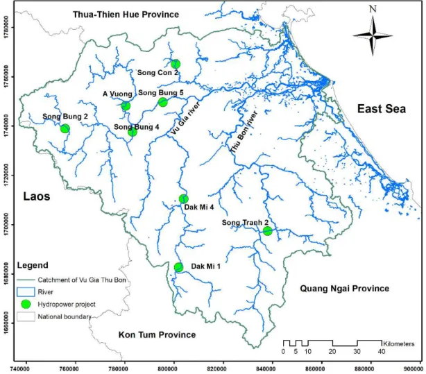
Figure 2. 1. Location of the Vu Gia Thu Bon catchment (Tran, 2018) ... 11
Figure 2. 2. Topography of the Vu Gia Thu Bon catchment ... 12
Figure 2. 3. River network in the Vu Gia Thu Bon catchment ... 14
Figure 2. 4. Gauging stations and four major reservoirs in the Vu Gia Thu Bon catchment ... 17
Figure 2. 5. The annual maximum water level at downstream: (a) Ai Nghia station and (b) Cau Lau station ... 18
Figure 2. 6. Hydropower projects in the Vu Gia Thu Bon catchment ... 20
Figure 2. 7. The four major reservoirs in the Vu Gia Thu Bon catchment ... 22
Figure 2. 8. A radial gate of A Vuong spillway ... 24
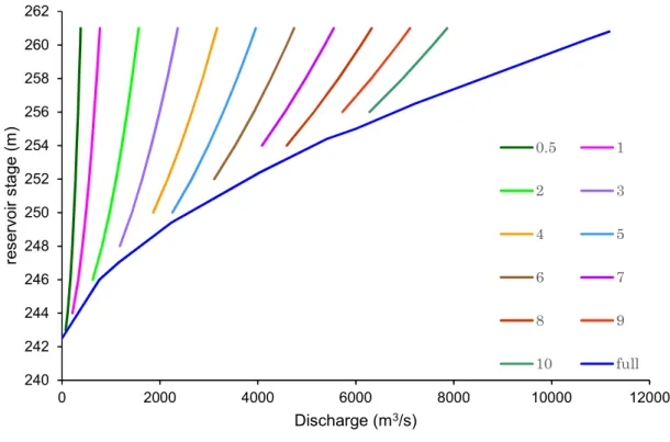
Figure 2. 9. Design characteristics of a reservoir ... 25
Figure 2. 10. Time-varying reservoir stage for the rule curves of the reservoir. .. 27
Figure 2. 11. Reservoir operating rule curves of A Vuong reservoir. ... 30
Figure 3. 1. The schematic of reservoir operation. ... 34
Figure 3. 2. Methodology flowchart for modeling of reservoir system operation. . 37
Figure 3. 3. The Mike 11 simulation editor. ... 39
Figure 3. 4. River network of the Vu Gia Thu Bon catchment in Mike 11 model. 39 Figure 3. 5. Typical cross-section of the upper (a) and downstream (b) Vu Gia river. ... 40
Figure 3. 6. Inflow reservoir hydrographs extracted from Mike SHE model. ... 41
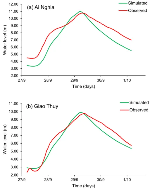
Figure 3. 8. Comparison of temporal variation of observed and simulated water level at Ai Nghia (a) and Giao Thuy (b) gauging stations during calibration of Mike
11 model ... 44
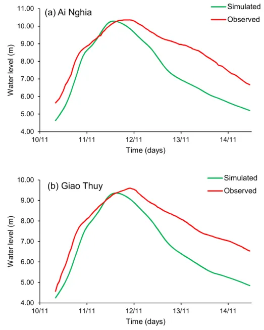
Figure 3. 9. Comparison of temporal variation of observed and simulated water level at Ai Nghia (a) and Giao Thuy (b) gauging stations during validation of 1D HD model ... 46
Figure 3. 10. Operational procedure on SO module... 48
Figure 3. 11. Definition of a radial gate ... 49
Figure 3. 12. The relation water level with storage of A Vuong reservoir; measured (solid) and estimated (red dots) ... 51
Figure 3. 13. Definition sketch for radial gate – free flow ... 52
Figure 3. 14. Definition sketch for radial gate – submerged flow ... 52
Figure 3. 15. Relations of spillway gate opening coupled with water level vs. water release ... 54
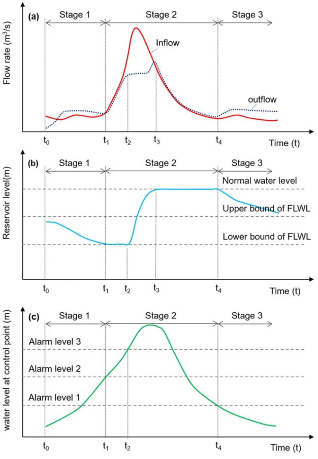
Figure 3. 16. Definition of the three flood stages during a flood event ... 58
Figure 3. 17. Operating rule curves of A Vuong reservoir. ... 59
Figure 3. 18. Dak Mi 4 reservoir operation in the 2007 flood season ... 62
Figure 3. 19. Flood control procedure for Dak Mi 4 reservoir in the 2007 flood season (detail A in Fig. 3.18 a) ... 63
Figure 3. 20. Flood control procedure for Dak Mi 4 reservoir in the 2003 flood season ... 65
Figure 4. 1. Flowchart of the simulation and optimization procedure. ... 72
Figure 4. 2. Flowchart of the SCE method (Duan et al., 1993) ... 79
Figure 4. 3. Illustration of the SCE algorithm. Extracted from (Duan et al., 1994) ... 80
Figure 4. 4. Illustration of the SCE algorithm. Extracted from (Duan et al., 1994) ... 81
Figure 4. 5. Flowchart of the AutoCal software. ... 83
Figure 5. 1. Description of the Vu Gia Thu Bon river-reservoir system ... 88
Figure 5. 3. Multistage parameters method scheme ... 91
Figure 5. 4. Basic steps of the Simulation-optimization framework ... 92
Figure 5. 5. Objective function for the different model evaluations ... 94
Figure 5. 6. Description of the four reservoirs and two control points in the Vu Gia Thu Bon catchment ... 95
Figure 5. 7. Hydrograph at Nong Son and Thanh My gauging stations in the 2007 flood event ... 96
Figure 5. 8. Inflow hydrographs entering four reservoirs (Vo & Gourbesville, 2016) ... 96
Figure 5. 9. Flood control procedure ... 98
Figure 5. 10. Comparison of operation process between three scenarios. ... 102
Figure 5. 11. Comparison of water level at the control points downstream. ... 103
Figure 5. 12. Runoff hydrographs of flood events at the control points. ... 104
Figure 5. 13. Operation of A Vuong reservoir in the 2009 flood event ... 106
Figure 5. 14. Inflow hydrographs of four reservoirs in flood event 2009 (Vo & Gourbesville, 2016) ... 107
Figure 5. 15. Comparisons between the current rules with the optimal operation for A Vuong and Song Tranh 2 reservoirs. ... 109
Figure 5. 16. Comparisons between the current rules with the optimal operation for Song Bung 4 and Dak Mi 4 reservoirs. ... 110
Figure 5. 17. Water level hydrograph of three scenarios at the control points ... 113
Figure 5. 18. Inflow hydrographs of four reservoirs in flood event 2017 ... 115
Figure 5. 19. Hydrographs of Dak Mi 4 and Song Bung 4 reservoirs in flood event 2017 ... 116
Figure 5. 20. Hydrographs of Song Tranh 2 and A Vuong reservoirs in flood event 2017 ... 117
Figure 5. 21. Water level hydrograph of three scenarios at the control points in 2017 flood event ... 119
Figure 5. 22. Runoff hydrographs of flood events 2017 at the control points. .... 120
Figure 6. 3. Flood limited water level (Hypothesis: flood season from 1st September
to 15th December) ... 129
Figure 6. 4. Increase of floodwater reduction with increasing flood control storage ... 130 Figure 6. 5. Flood control procedure. ... 132 Figure 6. 6. The Vu Gia Thu Bon river-reservoir system ... 133 Figure 6. 7. Hydrographs of the four reservoirs in the 2009 flood season (Vo & Gourbesville, 2016) ... 136 Figure 6. 8. Objective function values of evaluated decision variables sets ... 137
List of tables
Table 2. 1. Flood damages in Quang Nam province in the period 1997-2009 ... 19
Table 2. 2. Characteristics of hydropower project in the Vu Gia Thu Bon catchment ... 21
Table 2. 3. Characteristics of spillway gates ... 24
Table 2. 4. Reservoir characteristics in terms of flood control ... 26
Table 2. 5. Varying downstream warning water level for the operation rules of the reservoirs system ... 27
Table 2. 6. Defined discharge for the procedure of pre-release ... 28
Table 2. 7. Defined discharge for the procedure of flood control ... 29
Table 2. 8. Typical monthly stage in the Song Bung 4 reservoir ... 29
Table 3. 1. Performance criteria for model evaluation (Wang et al., 2012) ... 43
Table 3. 2. Statistical indices of Mike 11 model at downstream gauging stations ... 45
Table 3. 3. The characteristic of four radial gates ... 50
Table 3. 4. Discharge calibration factors and maximum discharge capacity of four spillway gates ... 53
Table 3. 5. Control definition for the spillway gates ... 56
Table 3. 6. The maximum and minimum discharge values of four HP ... 60
Table 3. 7. The maximum reservoir inflow based on historical data from 2003-2009 ... 60
Table 3. 8. Results for the floods event considered... 64
Table 4. 1. Algorithmic parameter for the SCE algorithm... 82
Table 5. 1. Results for the stopping criteria considered ... 93
Table 5. 2. Feasible parameter space for these parameters in the SCE algorithm ... 99
Table 5. 5. Results for three scenarios considered ... 111
Table 5. 6. The flood event in 2017 ... 114
Table 5. 7. Comparison of the flood operating results among operators and the proposed model ... 118
Table 6. 1. FLWL in reservoirs system (Government of Vietnam, 2015) ... 131
Table 6. 2. Defined discharge for the procedure of flood control ... 132
Table 6. 3. Feasible parameters space of upper bound of the FLWL ... 136
Table 6. 4. Maximum reservoir inflow corresponding the 20-years return period ... 137
Table 6. 5. The objective functions values of optimal the upper bound of FLWL using the SCE algorithm for different values of w1 and w2 ... 138
Table 6. 6. The optimal values of the upper bound of FLWL for different combinations of weights ... 138
Table 6. 7. The optimal values of the upper bound of FLWL for the balanced solution ... 139
Introduction
Chapter 1
Introduction
The current research targets the optimization of multi-reservoir system regarding the concurrent objectives of energy production and downstream flooding management. This chapter begins with a brief overview of problems related to hydropower project development and their influences on hydrological dynamic in rivers. The identification of key questions to be addressed and research objectives are presented. The overall organization of the thesis is concluding this first chapter.
Introduction
1.1. Background
Humans have been harnessing water to produce energy and perform work for thousands of years (Viollet, 2017). Hydroelectric power is considered as one of the oldest energy sources to generate mechanical and electrical energy. The main advantages of hydropower are a renewable power source, low operating costs in comparison with other power sources, a clean fuel source to the air, a flexible source since the hydroelectric plant can go from zero power to maximum power quickly to adapt energy grid demands. In addition to a sustainable fuel source, hydropower project construction may produce additional benefits such as irrigation, water supply for public and industrial activities, shipping and navigation, flood control, recreational activities and aquaculture. However, uses conflicts may appear among all of those activities and many recent examples have underlined this type of situation (Bene, 2018; Hess & Fenrich, 2017; Kalair, 2012).
In the past two decades, Vietnam economy has been developing remarkably. According to the World Bank (WB, 2016), the country is one of the most dynamic emerging countries in the East Asia region. The energy sector plays an essential part in fostering the socio-economic development of the country. Vietnam has a dense river system with a lot of large river basins (ADB, 2016). According to the assessment of energy potential, the total hydropower capacity is about 26,000 MW, with a total produced about 100 billion kWh (ICEM, 2008). Progress of total primary energy supply grew at 4.7% for the period time 2007-2017, in which hydropower experienced the highest growth at 14.5% (EREA & DEA, 2019). The role of hydropower for sustainable energy development is important (Kaygusuz, 2009), but problems related to the operating efficiency of existing reservoirs is still a considerable challenge. Vietnam is located in the tropical monsoon climate in which rainfall amount is abundant but strongly variable flow in time and space. The situation of too much wet season water and too little dry season water is causing many reservoir operating difficulties (Richaud et al., 2011). On the other hand, due to typhoons with heavy rains and complicated topography, floods become a constant threat to livelihoods located in the downstream areas. In such complex situation, reservoir operation is an intricate problem that involves multiple decision variables, numerous objectives, as well as significant uncertainties and risks (Anand et al., 2018; Oliveira & Loucks, 1997). In the Vietnamese context and even more globally, flood control and mitigation are
Introduction
a high concern for authorities who are responsible for reservoir operation in flood seasons and population safety. Obviously, each river system and catchment request a specific flood control system and ways of tackling floods may differ from one river to others. Therefore, designing optimal operation of multi-reservoir systems with multiple objectives is a major issue and represents a challenging task. Each decision taken for one reservoir would have significant impacts on the rest of other reservoirs in the system, as well as on flood conditions in the entire river basin (Che & Mays, 2017).
1.2. Problem description
The Vu Gia Thu Bon river basin is the fourth largest in terms of potential hydroelectric capacity in Vietnam after the Da, Dong Nai, and Se San river systems (ICEM, 2008). This basin plays a significant role in the social and economic aspects of the central region of Vietnam. The Government of Vietnam has planned eight large-medium hydropower projects on Vu Gia Thu Bon catchment in the seventh National Power Development plan with a total power capacity of approximately 1,100 MW (Government of Vietnam, 2011). Besides undeniable benefits, operating of the hydropower reservoir system still has some limitations and the project is frequently judged to have increased natural disasters in recent years. Flood damages caused by hydropower operation could elicit public outrage, leading to increases stress for decision-makers in performing the flood control operation (Chou & Wu, 2013). During the flood event in 2013, all hydropower reservoir operators stated that they had complied correctly with operational regulation. Still, the residents who suffered the severe flooding consequences did not absolve the responsibility of the operators (Luu et al., 2014). In such difficult and conflicting situations, the analysis of multi-reservoir system operation typically with optimization and simulation models can provide quantitative information to improve operational water management.
1.3. Research questions
The research area of this study is the reservoirs system on Vu Gia Thu Bon catchment. The four major reservoirs are vital engineering systems for flood mitigation and electricity generation. This research work focuses on the management and mitigation of flooding at the downstream area of the Vu Gia Thu Bon catchment. In this context, the main challenge of the research work is the optimal operation of the multi-reservoir system to mitigate flood
Introduction
damages in the downstream area. The following research questions are addressed:
What is causing flooding in the Vu Gia Thu Bon catchment, and what is the role of the hydropower reservoirs in reducing flood damages? What is the operating procedure in multi-reservoirs for flood
mitigation, and is it optimized?
What is the recent development in numerical operation reservoir simulation, and can it be used for multi-reservoir system in the Vu Gia Thu Bon catchment?
Could a novel method be proposed to deal with the optimal operation of the multi-reservoir system?
What are the adaptation strategies of reservoir operation for the Vu Gia Thu Bon multi-reservoir system?
To answer the above questions, a list of research goals has been identified and is addressed within this research project.
1.4. Research objectives
The overall objective is to identify the implications of optimal operation of the multi-reservoir system for flood control in the Vu Gia Thu Bon catchment and to propose a novel simulation-based optimization model that could be used for operational operation.
Following the overall objective, the specific goals of this research include: Analyzing general practices in flood control of reservoir system and
operation rules of the existing multi-reservoir system of the Vu Gia Thu Bon catchment.
Modeling and simulating the existing multi-reservoir operation according to the current regulations.
Combining simulation and optimization models in reservoirs system operation to optimize flood regulation strategy in the Vu Gia Thu Bon multi-reservoir system.
Using the simulation-based optimization technique to optimize the reservoir operation for flood control and validating implementation of the defined strategy with the recorded historical flood events.
Proposing strategies for optimal operation of the Vu Gia Thu Bon multi-reservoir system.
Introduction
1.5. Methodology
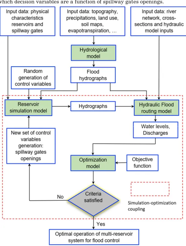
The current research aims to propose an overall method for calculating a multi-reservoir release strategy, which is implemented before, during, and after flood events. The problem is described as an optimal control problem, in which decision variables are a function of spillway gates openings.
Figure 1.1. Framework of the proposed methodology for optimal operation of multi-reservoir system.
Introduction
Fig. 1.1 shows the flowchart of the proposed approach for optimal operation of the multi-reservoir system in the Vu Gia Thu Bon catchment. The optimization-simulation model for multi-reservoir operation consists of three major components: (1) a hydraulic 1D model (Mike 11) that allows simulating the flows in a river system with different hydraulic structure (including the reservoir systems), (2) an operation reservoir model (Mike 11 Structure Operation (SO)) adopted for simulation of the multi-reservoir considering physical constraints of the system as well as operation strategies, and (3) an optimization model (the Shuffled Complex Evolution algorithm) applied to determine the best set of spillway gates levels, which specify the reservoir release.
The first component is the operation reservoir model (Mike 11 Structure Operation (SO) module) that requires the characteristics of reservoirs, the operation rules and reservoir inflows in order to start a reservoir operation simulation. The reservoir characteristics curves and operation rules are readily available at these reservoirs, however, the inflows are not available. In fact, in the Vu Gia Thu Bon catchment, there are only two stations (i.e., Nong Son and Thanh My stations) for measuring discharges. These stations are located at the middle of these branches (Fig. 1.2). Hence, the inflows must be estimated based on a rainfall-runoff model.
Vo (2015) has been successfully built a deterministic distributed hydrological model based on Mike SHE model and the efficiency of the model is also verified by the capability of predicting extreme peak flow and baseflow. Mike SHE is a deterministic modeling system based on physical laws (Jajarmizadeh et al., 2012). Most of the parameters used are physical variables that develop within a set of values that can be described by physical processes (Vo & Gourbesville, 2016a). Furthermore, the potential of overcoming the vulnerability and the lack of systematic data is one of the positives of the deterministic distributed models. With regard to the particular problems in the Vu Gia Thu Bon catchment, Mike SHE model represents an appropriate alternative for hydrological modeling in a situation of data scarcity.
Therefore, in the current research, reservoir inflow series are extracted from the hydrological Mike SHE model. Once the reservoir hydrographs are obtained, they are entered into the SO module as inputs. After that, this module computes gates openings and released outflows from the reservoirs
Introduction
based on the operational rules. The released hydrographs of the reservoirs are entered into the hydraulic model as boundary conditions.
Figure 1.2. Multi-reservoir system in the Vu Gia Thu Bon catchment. The second component is the hydraulic 1D model (Mike 11) that allows users to perform one-dimensional unsteady flow condition for the Vu Gia Thu Bon catchment. The 1D hydrodynamic model offers a much simpler model setup and faster computational time compared to those of complex hydrodynamic models like 2D or 3D models and the ability to use them in optimization models. This hydraulic model also computes the flow discharges and water levels in the river network considering the physical constraints of the system. The maximum water levels at the downstream control points are necessary to estimate the objective function of the optimization model.
The last component is the optimization procedure based on the Shuffled Complex Evolution (SCE) algorithm interfaces the simulation model to calculate gates levels during the operation of the multi-reservoir system. The SCE algorithm synthesizes the best features of several existing algorithms,
Introduction
including GA, and the complex shuffling This algorithm is one of the techniques that are robust optimization techniques to find the global optimum solution of complex problems with many functions such as non-convex, non-differentiable and multi extrema functions (Ngo et al., 2007). In the proposed methodology as shown in Fig. 1.1, first chromosomes are randomly generated in the feasible parameter space and entered into the operation reservoir model. After running the hydraulic model, the water surface elevations are obtained and can be used to estimate the objective function. Each decision variable is spillway gate levels in multi-reservoir system and these parameters are generated in the range of parameter space in the SCE optimization model.
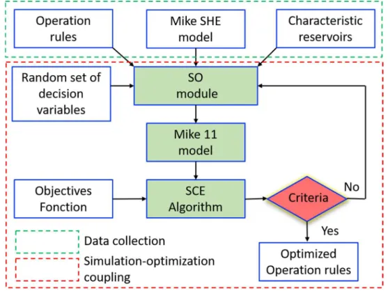
Figure 1.3. Interconnection of the components for optimal operation model of multi-reservoir system in the Vu Gia Thu Bon catchment.
Using this approach, the main objective of the method is to control flood flows and flood levels at various locations (i.e., control points) at the downstream of the Vu Gia Thu Bon catchment. The objective function is minimizing the total flood damages that can be expressed as a function of water surface elevations at the inundation zones - at Ai Nghia and Giao Thuy stations (Fig. 1.2). Fig. 1.3 describes a brief description of the interfacing of the components for optimal operation of the multi-reservoir system in the Vu Gia Thu Bon catchment. In the first step, the SCE optimization model produces a random
Introduction
set of decision variables, which are the input of the SO module such as spillway gates levels. Then the operation reservoir module SO computes gates openings and releases of reservoirs in the multi-reservoir system. Once sets of feasible solutions are determined, the releases are entered into the Mike 11 hydraulic model to compute the flow discharges and water levels of the river network considering physical constraints of the system. After that, the optimization model evaluated the objective function based on the selected results from the simulation model. Another set of control variable is then generated through the optimization algorithm. This process is repeated until the stopping criteria are satisfied. These include: the iteration number reaches a certain predefined, or the value of the objective function improves insignificantly over some iterations (i.e., less than 1%).
1.6. Structure of the thesis
Chapter 1 describes the scope of this research, research questions, research objectives and the organization of the thesis.
Chapter 2 provides a detailed introduction of the research area of Vu Gia Thu Bon catchment, the general processes and regulating principles of the reservoir operation for the Vu Gia Thu Bon catchment.
Chapter 3 describes the hydraulic model for river routing, the reservoir system operation model and their application for the multi-reservoir system of the Vu Gia Thu Bon catchment.
Chapter 4 provides a literature review of the application of optimization models for flood control, selection of optimization techniques and a brief overview of the shuffled complex evolution (SCE) algorithm.
Chapter 5 shows the application and results of the optimization-simulation model for the Vu Gia Thu Bon catchment using historical flood events in 2007, 2009 and 2017.
Chapter 6 introduces several approaches in dynamic control Flood Limit Water Level (FLWL) and presents optimal results of the FLWL for parallel reservoir system with multi-objective for the Vu Gia Thu Bon catchment. Chapter 7 summarizes the main findings and provides conclusions and perspectives regarding the proposed strategy and its operational implementation.
Vu Gia Thu Bon catchment context and challenges
Chapter 2
Vu Gia Thu Bon catchment context
Vu Gia Thu Bon catchment context and challenges
2.1. Vu Gia Thu Bon catchment overview
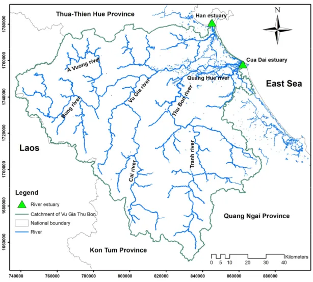
The Vu Gia Thu Bon is the biggest river basin in the central region of Vietnam which extending from 14°54’N to 16°13’N and 107°12’E to 108°44’E (Figure 2.1). The catchment borders on the Cu De basin to the north and the Eastern Sea to the east. It shares borders Tra Bong basin to the south, with the
Mekong basin to the west. The total catchment area is 10,350 km2, which 70%
mountainous, and 30% is foothill and plain, located in the major area of Quang Nam province and Danang city as well as small parts of Kontum province.
Vu Gia Thu Bon catchment context and challenges
The catchment’s natural topography divides the area into three major landscapes, the highlands, midlands, and lowlands (Fig. 2.2). The Truong Son mountain distinguishes the topography in the highlands with the highest elevation at over 2000 m and the Komtum mountain with mount Ngoc Linh as the highest mountain at 2598 m. On the one hand, the highland area presents steep sloping topography. The river is short and steep with narrow valleys, steep riverbanks, and many waterfalls and rapid flow. On the other hand, the midlands have lower hills ranging from 200 m to 800 m in comparison to the highlands (Fink et al., 2013), the river beds widen and shallow.
Figure 2.2. Topography of the Vu Gia Thu Bon catchment.
The topographic conditions of this area are advantageous for the hydropower project development, as is the case where a large number of hydropower facilities have been built in recent years ago. Areas below 25 m characterize lowlands; the riverbanks become low, allowing overflows into the fields and villages during the flood season. In the lowlands, the river system has many different connected branches by natural and artificial canals.
Vu Gia Thu Bon catchment context and challenges
The population of Quang Nam province reached 1,501,100 in 2018. In addition, the average annual growth rate of the population in this region was mentioned with 0.5 % between 2006 and 2014 (QSO, 2014). By contrast, the figure in Da Nang city was about five times higher in the same period and in
the period of 1995-2005, at 2,6 % and 2,4 %, respectively. (DSO, 2014). In
2019, the total population of Da Nang city increased to 1,134,310 persons with 86.9 % of people in the city living in urban areas compared with 32.2 % in Vietnam (DSO, 2019). The population in the Vu Gia Thu Bon catchment is densely concentrated in the lowlands, particularly in the cities, where the
density is over 5,000 persons per km2 (Nauditt & Ribbe, 2017).
The economy of the Vu Gia Thu Bon basin is diverse, including a changing primary sector consisting of agriculture, forestry, fishery and handicrafts. The economy of the region is rapidly changing from agriculture-based to industry and service-based, with an annual growth rate of over 10 % in the last decade (Trinh et al., 2017). Most economic centers are located in the lowlands, where posse high population density, crowded industrial and service zones and intensive agricultural activities supporting the dynamic growth.
In the period of 2011-2015, the national electricity consumption on average rose by 10.6 % per year. The electricity demand is predicted to be continued going up by about 8 % annually on average until 2035, corresponding to the additional requirement of 93 GW of power generation capacity during the period (MOIT & DEA, 2017). Hydropower is responsible for about 23.1 % of the nation’s electricity generation in 2020 (Government of Vietnam, 2011). Government of Vietnam has identified nine priority river basins for future hydropower development and the Vu Gia Thu Bon catchment is the fourth largest in terms of potential hydroelectric capacity in Vietnam after the Da, Dong Nai, and Se San river systems (ICEM, 2008).
2.2. Hydrological characteristics of the Vu Gia Thu Bon catchment
2.2.1. River network
The Vu Gia Thu Bon river network, originating from the eastern side of the Truong Son mountain range near the border to Laos, at an elevation of 2598 m. Flows through 17 districts of Quang Nam province and Danang city, the network drains to the East Sea at Han estuary in the Danang city and Cua
Vu Gia Thu Bon catchment context and challenges
Dai estuary near Hoi An ancient town. The Vu Gia Thu Bon catchment has two mains rives, the Vu Gia and the Thu Bon rivers (Fig. 2.3).
Figure 2.3. River network in the Vu Gia Thu Bon catchment.
The Vu Gia river is 204 km long and originates in the north-western of the Truong Son mountain range. This river has many tributaries, the Dak-Mi (or Cai river) from the south, the Bung river from the west, the A-Vuong river from the northwestern and the Con river. From upstream to Ai Nghia, the Vu
Gia river comprises an area of 5180 km2.
The Thu Bon river is 152 km long and originates at the high peaks of Ngoc
Linh mountain. The catchment area is 3825 km2 to Giao Thuy. Analogous to
the Vu Gia river, the Thu Bon river has tributaries such as Tranh river, Khang river, and Truong river.
There is a link between the two rivers through the Quang Hue river in the downstream part of the catchment. In the flood season, this river transfers flow from the Vu Gia river to the Thu Bon river. Approximately 16 km from the Quang Hue river to downstream, the Vinh Dien river transports water
Vu Gia Thu Bon catchment context and challenges
from the Thu Bon river and returns to the Vu Gia river in flood season. In addition to the flow exchange, additional water from other branches is also supplied to the mainstreams such as Ly Ly river to Thu Bon river; meanwhile, the Tuy Loan river contributes to the flow of the Vu Gia river.
2.2.2. Rainfall and runoff
Based in the south of the Thua Thien-Hue province and east of Laos, the climate in the Vu Gia Thu Bon catchment shows the typical weather in the south-central Vietnamese (Fink et al., 2013). It has relatively warm winters, hot summers, and a strong rainy season caused typhoons, from September to December.
Precipitations over the area are spatially variable. The average annual precipitation in the upland areas of the catchment is approximately 3000-4000 mm. This is roughly 50-100% higher than annual rainfall in coastal areas (about 2000 mm per year). It should be noted that this area is steep with narrow bends of the river. So most of the rainfall here is not held upstream but flows downstream and into the estuaries. Precipitation is also a temporary variable in the catchment. The rainy season begins in September and lasts until December, while the dry season is from January till August. About 65-80% of the amount accounts for the rainy season (Souvignet et al., 2014).
In terms of flow, a significant difference exists between the flood season and the dry season. The annual average of discharge of the Vu Gia river is about
120 m3/s, while the largest flow recorded about 7230 m3/s on 29th September
2009 at Thanh My gauging station. Similarly, the annual mean discharge of
the Thu Bon river is about 270 m3/s (Vu et al., 2017), while the largest flow
recorded about 10,600 m3/s and occurred in successive years, 1998 (December)
and 1999 (November) at Nong Son gauging station.
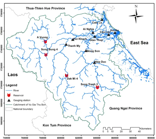
In the Vu Gia Thu Bon catchment, there are only two stations (i.e., Nong Son and Thanh My stations) for measuring discharges. These stations are located at the middle of these branches (Fig. 2.4). Hence, the inflows must be estimated based on a rainfall-runoff model. Vo (2015) has been successfully built a deterministic distributed hydrological model based on Mike SHE model and the model efficiency is likewise confirmed by the capacity to predict extreme peak flow and baseflow. Therefore, reservoir inflow series are extracted from the hydrology Mike SHE model (see the Appendix).
Vu Gia Thu Bon catchment context and challenges
2.3. Floods and flood damages
2.3.1. Floods
The major causes of floods in the Vu Gia Thu Bon catchment related to intense rainfall events are:
Direct influence by a storm or tropical depression hitting the watershed or moving along its seashore;
Intense Northeastern monsoons head towards the catchment, combined with the circulation of a storm or tropical; this complicated weather causes the heavy rain;
When the tropical depression zone appears in the South of the East Sea, simultaneously, in the North, a monsoon or Northeast wind is moving towards the South.
The collected data shows that out of 174 storms and tropical depressions taking place in the East Sea between 1997 and 2009 which 26 storms and 12 tropical depression affected directly to the Vu Gia Thu Bon catchment (Vo et al., 2011). The water level is observed at nine stations along two main branches of river system, Vu Gia and Thu Bon rivers (Fig. 2.4). The annual maximum water levels observed at various gauging stations downstream are shown in Fig. 2.5. The data is supported by the Mid-Central Region Centre for Hydro-meteorological Forecasting.
During 22 years (from 1995 to 2016), there were ten years that maximum water level reaches above warning level 3. The maximum level recorded occurred in 2007 and 2009. In recent years, flood water often rises quickly and more unpredictably, which becomes a growing concern of local people about increasing flood risks in flooding season.
Vu Gia Thu Bon catchment context and challenges
Figure 2.4. Gauging stations and four major reservoirs in the Vu Gia Thu Bon catchment.
There is a significant change in flood characteristics in recent years. Flood flow is stronger, the water level is higher, water recedes likely slower, and at the time, flood recession period occupied a longer time compared to the previous year from 2000. Previously, floods had risen slowly and receded quickly; local people had been able to forecast the intensity, hit time, and duration, which helped them prepare for the event.
The rainy season usually begins from September and ends in December, during which time heavy rain often happens and leads to an increase in flood risk in the catchment. Heavy rain and floods continued beyond the end of the rainy seasons, and irrigation and hydropower dams in affected areas reached maximum capacity, resulting in controlled water discharges that further intensified the flood impact downstream of the reservoirs.
Vu Gia Thu Bon catchment context and challenges
Figure 2.5. The annual maximum water level at downstream: (a) Ai Nghia station and (b) Cau Lau station
2.3.2. Flood damages
Vietnam is among those at the highest risk from natural disasters, with floods, droughts, severe storms, landslides, and forest fires having substantial economic and human impacts annually (Nga et al., 2015). Over the last two decades, natural disasters in Vietnam have caused more than 13,000 deaths and property damage over US$ 6.4 billions (World Bank, 2010). Annually, disasters cost Vietnam an average of up to 1.5 percent of its gross domestic product (GDP). 5 6 7 8 9 10 11 12 1994 1996 1998 2000 2002 2004 2006 2008 2010 2012 2014 2016 w a te r le ve l ( m ) Year
(a) Ai Nghia station Max water level
Level 1 Level 2 Level 3 1 2 3 4 5 6 1994 1996 1998 2000 2002 2004 2006 2008 2010 2012 2014 2016 w a te r le ve l ( m ) Year
(b) Cau Lau station Max water levelLevel 1
Level 2 Level 3
Vu Gia Thu Bon catchment context and challenges
In the Vu Gia Thu Bon catchment, the flood is the most destructive hazard causing major damage in properties and livelihood among the other natural disaster (Satriagasa et al., 2014). The loss of human lives and property losses caused by floods in the period 1997-2009 was provided by Quang Nam provincial steering committee for storm and flood control, given on Tab. 2.1. Although hydropower reservoirs in the Vu Gia Thu Bon catchment are not designed to provide complete protection against all possible floods, efficient operation of these reservoirs can reduce flood levels and prevent major flood disasters.
Table 2.1. Flood damages in Quang Nam province in the period 1997-2009.
Year Death Missing Injured Damages costs
(Persons) (Persons) (Persons) (Billions VND) (Millions US$*)
1997 33 0 0 100 5.4 1998 54 1 36 390 21.1 1999 118 0 339 758 41.1 2000 13 0 0 139 7.5 2001 13 1 9 76 4.1 2002 0 0 0 2 0.1 2003 32 2 5 91 4.9 2004 19 23 13 156 8.4 2005 12 5 24 110 6.0 2006 176 1 562 1901 103.0 2007 47 0 339 2000 108.3 2008 33 0 3 155 8.4 2009 52 0 220 3700 200.4
* US Dollar exchange rates for 31 December 2009: 1 USD to VND = 18,465.
2.4. Hydropower reservoirs system
2.4.1. Hydropower projects development
Over the last two decades, Vietnam is a dynamically developing economy with a relatively high growth rate. According to the World Bank (WB, 2016), the country is one of the most dynamic emerging countries in East Asia. The energy sector plays an important part in fostering the socio-economic development of the country. Vietnam has a dense river system with a lot of large river basins. As a cheap and available source of energy, hydropower is
Vu Gia Thu Bon catchment context and challenges
a key component of the national energy mix (Nguyen-Tien et al., 2018). According to estimations, the total technical hydropower capacity is about 26,000 MW, with a total produced about 100 billion kWh. Progress of total primary energy supply grew at 4.7% between 2007-2017, in which hydropower experienced the highest growth at 14.5% (EREA & DEA, 2019). After the Da, Dong Nai, and Se San river systems, the Vu Gia Thu Bon river basin ranks fourth in potential hydroelectric capacity in Vietnam (ICEM, 2008). This basin plays a significant role in terms of social and economic points of view for the central region of the country. According to the Seventh National Power Development Plan, the Government of Vietnam has listed eight large-medium hydropower projects (i.e., more than 30 MW) for the Vu Gia Thu Bon catchment with total power capacity is approximately 1,100 MW (Fig. 2.6). The major characteristics in terms of 8 hydropower projects, are listed in Tab. 2.2.
Vu Gia Thu Bon catchment context and challenges T ab le 2 . 2. C h ar ac te ri st ic s of h yd ro p ow er p ro je ct i n t h e V u G ia T h u B on c at ch m en t S on g B u n g 2 S on g B u n g 4 S on g B u n g 5 D ak M i 2 D ak M i 4 S on g C on 2 A Vu on g S on g T ra n h 2 B as in a re a at d am K m 2 33 4 14 48 23 69 44 5 11 25 25 0 68 2 11 00 M ea n a n n u al f lo w m 3/s 18 .7 73 .7 11 8 28 .4 67 .8 13 39 .8 11 4 N or m al w at er l ev el m 60 5 22 2. 5 60 63 0 25 8 27 8 38 0 17 5 D ea d w at er l ev el m 56 5 20 5 58 .5 62 4 24 0 27 6 34 0 14 0 A ct iv e st or ag e 10 6 m 3 73 .9 23 3. 99 2. 45 0. 69 2 15 8. 26 0. 7 26 6. 48 52 1. 1 In st al le d ca pa ci ty M W 10 0 15 6 57 98 14 8 50 21 0 19 0 T u rb in e di sc h ar ge m 3/s 34 .5 16 6 23 9. 24 44 .3 6 12 8 25 78 .4 24 5 D am h ei gh t m 96 11 4 41 .5 30 90 16 .5 80 96
Vu Gia Thu Bon catchment context and challenges 2.4.2. Reservoirs system general description
The steep slope of mountainous topography greatly limits the capacity of reservoirs in the central region of Vietnam in general and of reservoirs in the Vu Gia Thu Bon catchment in specific. Most projects are using dams for the impoundment of the river and using potential heads of the rivers to build a system of hydropower reservoirs cascade. All of these large hydropower reservoirs in the Vu Gia Thu Bon catchment are used a guiding channel for transferring water from the reservoir to the hydropower plant. Since 2015, eight large-medium sized dam projects have been constructed on the mainstream of the river basin. However, there are only four hydropower reservoirs with capacity flood control, including A Vuong, Dak Mi 4, Song Bung 4 and Song Tranh 2 (Fig. 2.4). These four reservoirs play the most important role in flood control in the Vu Gia Thu Bon catchment.
(a) A Vuong reservoir (b) Dak Mi 4 reservoir
(c) Song Bung 4 reservoir (d) Song Tranh 2 reservoir
Figure 2.7. The four major reservoirs in the Vu Gia Thu Bon catchment. A Vuong reservoir (Fig. 2.7a) is located on the A Vuong river within Hien district in Quang Nam province. A Vuong river is a tributary of the Bung river, which originated northwest mountain with elevation 1400m. The
Vu Gia Thu Bon catchment context and challenges
catchment area is 682 square kilometers downstream to the A Vuong dam site. The dam height will be 80 meters, and it will create a reservoir with an
area of 9.09 km2 at the normal water level. The hydropower plant has 210
MW with two units. The design head is 300 m, and the project has to mean an annual energy potential of 815 million kWh.
Dak Mi 4 reservoir (Fig. 2.7b) is to built and operates a hydropower plant with an accumulation reservoir in the Phuoc Son district in Quang Nam province. This project produces 752 million kWh per year with an installed capacity of 190 MW. The project contains an upper cascade, Dak Mi 4a, with a capacity of 148 MW and a lower cascade, Dak Mi 4b, with a capacity of 42 MW. The dam built in the Cai river, one of the major tributaries of the Vu Gia river. The upper dam has a reservoir area at the normal water level of
10.44 km2. This project started into operation in 2012.
Song Bung 4 reservoir (Fig. 2.7c) is located on the Bung river, a tributary of the Vu Gia river, within Nam Giang district of Quang Nam province. The dam sites on the boundary of Zuoih and Ta B’Hing commune and the reservoir inundate part of these two communes. Water from the reservoir is diverted to a tunnel of length 3.2 km and penstock to a power station located about 5 km downstream of the dam. The hydropower facility has 156 MW and has a mean annual energy potential of 222 million kWh.
Song Tranh 2 (Fig. 2.7d) reservoir is a large reservoir of 730 million m3
volume, making it one of the most significant reservoirs in the central of Vietnam. The hydropower project is located on the mainstream of the Tranh river, which is a part of the Thu Bon river, with a capacity of 190 MW, having annual energy electricity of 679 million kWh. This project was constructed in 2006 and was completed in 2011.
Mitigation of flood damages is the first priority for operational reservoirs system during flood season (from September to December) in the Vu Gia Thu Bon catchment.
2.4.3. Spillway gates description
The four reservoirs have gated spillway to control reservoir outflow during flood events that protect the safety of their dams and the headwork. The spillway gates sized to safely pass floods equal to or less than the probable maximum flood. The operation of the spillway gates depends on the state of the reservoir, reservoir inflow, and operation strategy. Type of the spillway
Vu Gia Thu Bon catchment context and challenges
gates of four reservoirs in the Vu Gia Thu Bon catchment is the radial gate (Fig. 2.8). Main characteristics of four spillway gates givens in Tab. 2.3.
Table 2.3. Characteristics of spillway gates.
A Vuong Dak Mi 4 Song
Bung 4
Song Tranh 2
Crest level of weir (m) 363 242.5 210.5 161
Number of gates 3 5 6 6
High of gate (m) 17.5 16 12 14
Wide of gate (m) 14 14 12 14
Capacity of passing* (m3/s) 5720 8584 6363 9035
* maximum discharge capacity corresponding the normal water level.
Figure 2.8. A radial gate of A Vuong spillway.
2.5. Reservoir operational regulation
2.5.1. Basic terminology
This research work focuses on the optimal multi-reservoir operation for flood control that essentially means determining operation strategies, defining a schedule of spillway gates to fulfill objectives best. An operational regulation
Vu Gia Thu Bon catchment context and challenges
is a set of rules for determining the amount of water released during flood season from reservoir systems under various conditions. Regulation of the multi-reservoir in the Vu Gia Thu Bon catchment based on reservoir inflows, downstream conditions, and storage levels. Different storage levels include (Fig. 2.9):
Dead water level; Normal water level; Design flood level;
Exceptional (check) flood level; Flood limit water level.
Figure 2.9. Design characteristics of a reservoir.
Flood Limit Water Level (FLWL) is an operational level designed to reserve adequate flood control capacity. The general rule about FLWL is that the storage level of the reservoir is not allowed to exceed FLWL during the flood season to offer adequate storage for flood prevention. According to the operational regulation of the multiple reservoirs system in the Vu Gia Thu Bon catchment, the reservoir levels can fluctuate between the upper limit and the lower limit of the dynamic control of FLWL. Different storage levels and flood control characteristics of four major reservoirs in the Vu Gia Thu Bon catchment are listed in Tab. 2.4.
Vu Gia Thu Bon catchment context and challenges
Table 2.4. Reservoir characteristics in terms of flood control.
Reservoir A Vuong Dak Mi 4 Song Bung 4 Song Tranh 2
Exceptional (check) flood level (m) 382.2 260.33 228.11 178.51
Normal water level (m) 380 258 222.5 175
Dead water level (m) 340 240 205 140
Upper bound of FLWL (m) 376 255 217.5 172
Lower bound of FLWL (m) 370 251 214.3 165
Reservoir storage (106 m3) 343.55 312.38 510.8 729.2
Active storage (106 m3) 266.48 158.26 233.99 521.1
Flood control storage (106 m3) 35.14 31.07 75.3 61.45
2.5.2. Multi-reservoir operational regulation Regulation for flood control
Hydropower reservoir development and management are achieved within a complex system of organizations, laws and encompassed also traditions. In addition to the agency that owns and operates the reservoir, numerous other public agencies, officials, project beneficiaries, interest groups, and concerned citizens play significant roles in determining operating policies (Wurbs, 1991). According to the decision of the Government of Vietnam, the Steering Committee for Disaster Prevention, Search and Rescue of Quang Nam province takes responsibility for the operation of the reservoir systems in the Vu Gia Thu Bon catchment during the flood season.
The four major reservoirs in the Vu Gia Thu Bon catchment include A Vuong, Dak Mi 4, song Tranh 2, and song Bung 4, which were operated in the years 2009, 2011, 2012 and 2014, respectively. Following the operational
regulation, the flood season from 1st September to 15th December of every
year. In the flood season, reservoirs system is operated in the following order of priority:
Strictly ensuring the safety of the dams: the maximum water levels do not exceed the exceptional (check) flood level for all floods that provide by Tab. 2.4;
Taking part in reducing downstream floods; Ensuring efficiency in hydropower generation.
Vu Gia Thu Bon catchment context and challenges
The storage levels in the reservoirs should be kept below the upper bound of flood limit water level (Fig. 2.10) to provide sufficient storage for flood mitigation.
Figure 2.10. Time-varying reservoir stage for the rule curves of the reservoir. Table 2.5. Varying downstream warning water level for the operation rules of
the reservoirs system
Hoi Khach Ai Nghia Nong Son Cau Lau
Level 1 (m) 14.5 6.5 11.0 2.0
Level 2 (m) 15.5 8.0 13.0 3.0
Level 3 (m) 16.5 9.0 15.0 4.0
H3 (m) 16.0 8.5 14.0 3.5
The regulation of operation for flood mitigation consider the key parameters follow in the flood season:
The reservoir stages in reservoirs system;
The water level at the downstream control point: operation of A Vuong, Dak Mi 4 and Song Bung 4 reservoirs define by the water level at Hoi Khach and Ai Nghia stations while the operation of Song Tranh 2 defines by the water level ay Nong Son and Cau Lau stations (Tab. 2.5);
Vu Gia Thu Bon catchment context and challenges
Hydrological forecast information: 24-48h forecasts of the inflows information.
Operational regulation of multiple reservoirs in the Vu Gia Thu Bon catchment defines three regulation periods to reduce floods hitting lowlands during flood season as follows:
The procedure of pre-release: the objective of this procedure to release a proportion of the usable volume of reservoirs before flooding occurs and allows the reservoirs to reduce the water level. The release discharge should be greater than the inflow discharge to reduce the reservoir stage to lower bound of FLWL with conditions following:
The reservoir stage is above the lower bound of FLWL;
The water level at the downstream control points is lower than the water level 2 (Tab. 2.5);
Vietnam Meteorological and Hydrological Administration (VMHA) forecast heavy rainfall, flood in the next 24-48h or reservoir inflows are greater than the discharge value defined by Tab. 2.6:
Table 2.6. Defined discharge for the procedure of pre-release.
A Vuong Dak Mi 4 Song Bung 4 Song Tranh 2
Discharge (m3/s) 450 550 550 900
During the pre-release procedure is effectuated; if the water level at the downstream control points is greater than the water level 2, the release discharge should be equal the inflow discharge to maintain the reservoir stages.
Procedure during a flood event: the objective of this procedure is to reduce major downstream floods in the Vu Gia Thu Bon catchment. The reservoirs have to store water to reduce the flows to downstream with one of the conditions following:
The water level at the downstream control points is greater than the
water level of H3 (Tab. 2.5);
Reservoir inflows are greater than the discharge value defined by Tab. 2.7:
Vu Gia Thu Bon catchment context and challenges
Table 2.7. Defined discharge for the procedure of flood control
A Vuong Dak Mi 4 Song Bung 4 Song Tranh 2
Discharge (m3/s) 600 700 700 1500
The release discharge should be less than the reservoir inflow so that the reservoir stage will be rising. When the reservoir stage reaches the normal water level, this procedure will be changed to the procedure for the safe protection of the dam.
Procedure for safe protection of the dams: in the case where the water
level at downstream control points is greater than the value of H3 (Tab. 2.5),
the reservoir stages reach the normal water level and there are floodings in the catchment that are increasing, the procedures are changed to dam protection. Based on the reservoir stages and reservoir inflow, a step-by-step opening the spillway gates to control release discharge equal to reservoir inflow.
Procedure of post-flood: the post-flood procedure is a method for ensuring the reservoir stage is descending to the upper bound of FLWL (Tab. 2.4) for the next flood event. The total discharge release greater than the reservoir inflow during the period from 24 to 72 hours with conditions following:
The water level at the downstream control points is lower than the warning water level 1 (Tab. 2.5).
For a detailed description of the regulation, refer to Decision 1537 of (Government of Vietnam, 2015).
Regulation for hydropower generation
The reservoir in the Vu Gia Thu Bon catchment operates for seasonal regulation of the flows. Hydrological characteristic includes the wet season or the flood season (September to December) and the dry season (January to August).
Table 2.8. Typical monthly stage in the Song Bung 4 reservoir.
Sep Oct Nov Dec Jan Feb Mar Apr May June July Aug Reservoir
Vu Gia Thu Bon catchment context and challenges
The reservoir stages will be filled up to the normal water level during the wet season and be drawn down to the dead water level at the end of the dry season. An example of the typical variation of reservoir stages during the year of the Song Bung 4 hydropower reservoir, shows in Tab. 2.8.
Rule curves generally maintain regulation for hydropower generation. The operating rule curves enable visual expression of the operating strategy (Chang et al., 2005) and are derived from different operating guidelines curves. As illustrated in Fig. 2.11, the operation guide curve was defined with the fewest possible variables. In this study, hydropower generation is the second objective of the reservoir system in the flood season. Therefore, the operation to get as much hydropower as possible within the constraints of the flood reduction strategies. It consists of three zones, as shown in Fig. 2.11 to define how much water is supplied in the model for hydropower generation.
Modeling and simulation of the river-reservoir system
Chapter 3
Modeling and simulation of the
river-reservoir system
The objective of this research is the optimal operation of the multi-reservoir system in the Vu Gia Thu Bon catchment for flood mitigation. These are two steps. The first step is to simulate the operation of the reservoir system using a 1D hydraulic model (Mike 11). The second step is the coupling simulation model with the optimization model to the optimal operation of spillway gates for flood mitigation during the flood event. This chapter describes the operation reservoir simulation model and application in the Vu Gia Thu Bon multi-reservoir system.