HAL Id: hal-00520233
https://hal.archives-ouvertes.fr/hal-00520233
Submitted on 22 Sep 2010HAL is a multi-disciplinary open access archive for the deposit and dissemination of sci-entific research documents, whether they are pub-lished or not. The documents may come from teaching and research institutions in France or abroad, or from public or private research centers.
L’archive ouverte pluridisciplinaire HAL, est destinée au dépôt et à la diffusion de documents scientifiques de niveau recherche, publiés ou non, émanant des établissements d’enseignement et de recherche français ou étrangers, des laboratoires publics ou privés.
EXTENSION OF INNOVATIVE FARMING SYSTEMS
AT THE REGIONAL SCALE? SCENARIO ANALYSIS
OF ORGANIC AGRICULTURE IN THE CAMARGUE
Sylvestre Delmotte, Santiago Lopez-Ridaura, Jean-Marc Barbier, Jacques
Wery
To cite this version:
Sylvestre Delmotte, Santiago Lopez-Ridaura, Jean-Marc Barbier, Jacques Wery. HOW TO EVAL-UATE THE IMPACTS OF THE EXTENSION OF INNOVATIVE FARMING SYSTEMS AT THE REGIONAL SCALE? SCENARIO ANALYSIS OF ORGANIC AGRICULTURE IN THE CAMAR-GUE. ISDA 2010, Jun 2010, Montpellier, France. 17 p. �hal-00520233�
ISDA 2010, Montpellier, June 28-30, 2010 1
HOW
TO
EVALUATE
THE
IMPACTS
OF
THE
EXTENSION
OF
INNOVATIVE
FARMING
SYSTEMS
AT
THE
REGIONAL
SCALE?
SCENARIO
ANALYSIS OF ORGANIC AGRICULTURE IN THE
CAMARGUE
Sylvestre DELMOTTE*, Santiago LOPEZ-RIDAURA*, Jean-Marc BARBIER*, Jacques WERY**
* INRA, UMR Innovation, 2 place Pierre Viala, 34060 Montpellier Cedex 2, France ** SupAgro, UMR System, 2 place Pierre Viala, 34060 Montpellier Cedex 2, France
Abstract — The Camargue, South of France, is an agricultural region highly multifunctional and with strong issues linking the environment and the society. Evaluating scenarios of alternative agricultural systems extension in this region imply to use tools that allow Prospective, Integrated, Multiscale and Participatory Assessment of Agricultural Systems (PIMPAAS). In this paper, we reviewed the use of three approaches (BEM, ABM and LUCC) for PIMPAAS. After a presentation of the three approaches, we analyzed their advantages and drawbacks, and possible complementarities. As it is not possible to implement the three approaches together at one time, our aim was to make a choice for the Camargue. We found LUCC to be the least suitable approach, mainly because it does not allow participatory processes at farm scale. BEM and MAS appeared to be the most suitable tools as they allow quantitative and ex-ante studies and are able to incorporate the three sustainability domains. Their ways of up-scaling are complementary: BEM seems efficient for up-scaling from field to farm and field to region, whereas MAS allow up-scaling without aggregation from farm to region. We believe that the combination of the two approaches will enable highly participatory evaluations of alternative farming systems. Using the results of this analysis, we recommend using a combination of MAS and BEM in a global framework.
We are currently implementing a framework in the Camargue to test this combination and to evaluate its suitability for prospective, multiscale, multicriteria and participatory evaluation.
Key words : Prospective, Integrated, Multiscale, Participatory, Scenario evaluation,
Agro-ecosystem Indicator, Model
1. INTRODUCTION
Linking agricultural production and nature conservation is one of the greatest challenges of land use systems nowadays, and the design of innovative, multifunctional, farming systems is a possible solution. The implementation of such innovative farming systems requires a set of coordinated actions at different scales to make sure that innovations (i) contribute to the economic and environmental objectives on a given region (increasingly important for the whole agricultural profession) and (ii) do fit in with the functioning of the farm as a whole and are compatible with the farmers’ policy setting.
Evaluating the impacts of the extension of innovative farming systems at regional scale requires a prospective analysis to shed light on the plausible consequences of their adoption at different scales and to identify the main opportunities and bottlenecks in their implementation. The views and evaluation criteria of different stakeholders operating at different scales (from farm to region) must be taken into account to enhance the chances of success in the implementation of such innovative farming systems. In the next paragraph, we argue why a Prospective, Integrated, Multiscale and Participative Assessment of Agricultural Systems (PIMPAAS) must be carried out. The approach is illustrated using the Camargue case study.
The Camargue is a deltaic region in the South of France of 167 000ha among which around 70 000 are cultivated. Agriculture plays a crucial role in the economic, ecologic and social equilibrium of the region. It has been labeled as a reserve of biosphere (Man And Biosphere Program of UNESCO) since 1977, and it hosts also a Natural Regional Park, a National Reserve and many other associative or private protected areas. Several fauna and flora species are protected and eco tourism is an important activity.
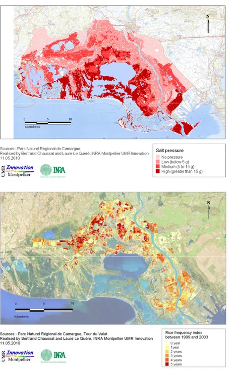
ISDA 2010, Montpellier, June 28-30, 2010 2 Agriculture in the Camargue plays a crucial role in the water dynamics as most land is at sea level and salinisation is a natural process due to the negative water balance between rainfall and evapo-transpiration in this windy Mediterranean climate. Figure 1 shows a map of salt pressure in the Camargue. Salt pressure is closely associated to altitude being the lowlands the most exposed to this problem.
In the Camargue, about 20 000 ha are devoted each year to rice production. It is the only place where rice production is done in continental France. Irrigation of rice plays a key role in desalinating the soils as fresh water from the Rhone river enters the delta (Figure 2). However, continuous rice production uses large quantities of pesticides, notably herbicides. These pesticides disperse throughout the environment and, given the high diversity and interest of the local fauna and flora, ecologists have long called for a reduction in the use of pesticides.
Fig. 1. Cartography of salt pressure in the Camargue territory. Salt pressure is closely associated to altitude, the low lands being the most exposed to salt.
Fig. 2. Cartography of Rice frequency in the Camargue. The more red it is, the more rice is present between 1999 and 2003. This map shows that most continuous rice cropping systems does not take place where maximum salt pressure occur. This militates for taking into account individual strategies and
values, through participatory exercises.
ISDA 2010, Montpellier, June 28-30, 2010 3 Comparing figures 1 and 2, it can be seen that most continuous rice cropping systems does not necessarily takes place where maximum salt pressure occur. Re-allocating intensive (continuous) rice cropping systems in areas with high salt pressure and more extensive (with lower use of pesticides, eg. Organic) rice production systems in areas with less salt pressure, may represent a solution to both, salt pressure and pesticide use.
This salt pressure and pesticide issue, is only an example of the kind of issues that require a PIMPAAS approach. The plausible consequences of the extension or redistribution of different agricultural alternatives must be analyzed at different scales, with a multicriteria perspective and in close interaction with local actors taking into account their individual values and strategies.
Organic farming in Camargue: need for PIMPAAS Prospective
Organic farming has been presented as a potential way of reducing the externalities of actual agricultural practices, The French government has launched a program to reach 6% of the farm land converted to organic by 2012 and 20% by 2020 (Barnier, 2007). Organic farming represents yet nearly 5% of the total area of cultivated land in the Camargue; however rising 20% in 10 years poses new questions. An extension of the area will certainly have multiple impacts in the region: technical issues will arise such as the need of organic fertilizers in high quantity or the impacts of a decrease in irrigated area linked to the reduction of rice frequency in the rotations. Scenario evaluation of organic agricultural systems in this region implies the use of available data that are dispersed in term of origin and are scale specific: for example, data exists from experiments at field scale and many experts have knowledge about constraints and opportunities for the adoption of organic agriculture. There is then a need for a methodology that would help organizing these data for a prospective study. Integrated
As shown in other European regions, the development of organic farming will have an important influence in the economy of farmers (Darnhofer et al., 2009). However, it may also impact the economic, social and environmental equilibrium of the region through, for example the generation of employment, the quantity of rice available for cooperatives and processing industries, and the visibility of the region through an aura of ‘organic region’, what would certainly encourage green tourism and activities oriented to nature. Indicators must then be calculated for each of t the three sustainability domains: economic, social and environmental. Coping with this multitude of criteria and indicators implies the use of integrated approaches, including knowledge from different disciplines such as economy, ecology and social sciences.
Multiscale
The organic option for rice production in the Camargue to avoid the build up of weeds and pathogens in the rice fields, is to break the continuous rice cropping and lengthen the rotations with dry crops (cereals and leguminous such as wheat and alfalfa). The extension of these systems in the region would certainly imply a decrease in the area of irrigated rice and therefore the quantity of fresh water entering the delta (Chauvelon, 1998). In fact, organic rice has to be rotated with other crops over five years (Mouret et al., 2004), whereas in conventional cropping systems, it is possible to grow rice continuously by using herbicides. If rice is included less frequently in the rotation, the quantity of irrigated fresh water will decrease, with possible consequences on the salinity of the Vaccares lake and on the area for feeding and reproduction of wild birds. As this last example shows, the decision of adopting or not organic farming is usually taken at farm scale and implemented at field scale, while the impacts of this adoption must be studied at farm and regional scale. The evaluation of the economic performance of a farm is commonly conducted on a yearly basis, whereas at the regional scale, the evaluation of economic performance of the agricultural sector is often averaged per decades. Therefore, a multi-scale approach in term of space and time is
ISDA 2010, Montpellier, June 28-30, 2010 4 needed to study the plausible consequences of such conversion to organic agriculture in Camargue.
Participative
Multiple stakeholders have to be taken into account in the analysis of scenarios related to the extension of organic farming in the Camargue. Even if the farmers remain the main decision-makers on which agricultural activities are carried out, other stakeholders can influence them through regulations, incentives, prices and services. For example, hunters pay farmers in the Camargue to keep rice fields flooded during winter making it impossible to grow a rainfed winter or spring crops in the following year. In the economic balance of the farm, it is then important to consider this side-activity and its impact on farmer’s income and therefore choice for land-use. To take into account in the evaluation such local specificities, it is necessary to associate the stakeholders strongly in the evaluation of scenarios. This would ensure the consideration of local knowledge and perceptions, the identification of possible conflicts among interest of different stakeholders as well as possible synergies. Participative studies have been conducted in the Camargue to understand the links between fishermen, reed harvesters, hunters and ecologists (Mathevet et al., 2003). It becomes now important to expand such approach to the links between agriculture and environment in this territory. Carrying out a PIMPAAS in the Camargue has become necessary as the future of agriculture in this territory faces new challenges concerning the co-habitation of agricultural activities and nature conservation goals.
Based on a literature review (Delmotte et al., Submitted), we identified three approaches commonly used for scenario analysis in relation to agricultural systems and land use. They are based on modeling which is necessary for quantitative and explorative studies: (i) Bio-economic models (BEM), (ii) Multi-agent models (MAS) and (iii) Land use/cover change models (LUCC). The objectives of this paper are (i) to present a comparative analysis of these three approaches (ii) to identifying their main advantages and drawbacks as well as possible complementarities, and (iii) to develop and apply a participatory, scale, multi-criteria method for scenario analysis of organic farming systems extension in the Camargue region, South of France
2. PRESENTATION OF THE THREE APPROACHES 2.1 Land Use / Land Cover Change models
2.1.1 Definition
The objective of Land Use/Land Cover Change (LUCC) studies is to describe the actual land use and to give insights on the possible changes of land use pattern that would occur in the near future following either some biophysical or demographic changes (Veldkamp and Fresco, 1996) or economic and structural changes (Verburg et al., 2004). LUCC approaches cover a wide range of methods but most of them are “descriptive models that aim at simulating the functioning of the land use system and the spatially explicit simulation of near future land use patterns” (Verburg et al., 2004).
Land use is generally described in a raster based geographical information system. Each cell contains different economic, social and biophysical information such as population, land use, distance to the roads or markets. Statistical analyses are conducted to identify the drivers that are correlated with the observed past or current land use. These driving factors can be socio-economic aspects, such as demography and infrastructure (road, presence of a market for example), or biophysical aspects such as type of soil and climate. For scenario analyses, the demand of commodities is assumed as one of the main drivers for land use change. For each scenario, a new demand for each time-step of the simulation is formulated from past trends, experts knowledge or stakeholders opinions (Veldkamp and Fresco, 1996). This demand is then converted quantitatively in area of land that has to be allocated to a specific land use. On the basis of the statistical relationship derived from the past and actual land use, probable hotspots of land use change are identified.
ISDA 2010, Montpellier, June 28-30, 2010 5
2.1.2 Applications
Different models exists in the literature for deforestation (GEOMOD 2, (Pontius et al., 2001)), urban extension (White and Engelen, 2000) and agriculture (CLUE-S (Verburg et al., 2002)). In CLUE (Conversion of Land Use and its Effect), correlations between the actual land use and biophysical and socio-economics factors are tested. These correlations are used to evaluate what would be the plausible change in land use following for example a change in commodity demand, policy instruments and, infrastructure development, (de Koning et al., 1999).
2.2 Bio-Economic Modelling
2.2.1 Definition
Bio-Economic Models (BEM) are economic models that include a biological component to take into account temporal variation of agricultural activities performance and impacts due to climate and soil factors variability. BEM aim at identifying optimum combinations of agricultural activities that maximize or minimize an objective. Optimum systems are often obtained using a Multiple Goal Linear Programming (MGLP) model where one goal is defined by an objective function, the others being described in constraint functions (Janssen and van Ittersum, 2007). This optimization has been done for objectives defined at different scales, most commonly at the farm (Janssen and van Ittersum, 2007) and regional scale (Laborte et al., 2007).
In BEM, agricultural activities are quantitatively described at the field or livestock unit scale by their inputs and outputs (called technical coefficient) representing their performance in terms of desired goods and the environmental externalities attached to them. Commonly, each activity can be described by a set of data that give information on labor, nutrients balances, greenhouse gas emissions, use of inputs, expected performance considering inter-annual variations, and many others. These data can be obtained from different data sources such as interviews with farmers, experimental data (Roetter et al., 2007), expert knowledge (Kerselaers et al., 2007) and models (crop, livestock, soil dynamics models) (van Ittersum et al., 2008). Technical coefficients generators (Hengsdijk et al., 1999) can be developed that summarize the main processes and generate the inputs and outputs used for optimization models.
2.2.2 Applications
Mathematical programming, at the basis of BEM, has become a common tool in agricultural sciences in the last decades in support for decision-making and assessment of agricultural systems. Mathematical programming offers several optimization techniques being Linear Programming (LP) the most commonly used. LP has been widely used in agricultural economics with the objective function representing the economic rationale of the farmer’s decision process, and the optimization aims at identifying the combination of agricultural activities that maximize an utility function. The utility function is defined in monetary terms, meaning that all objectives and constraints, as well as the technical coefficients describing the activities, have to be converted into money. In BEM, MGLP models are commonly used where objective functions and constraints are represented in separate equations keeping their own units allowing then a multi-criteria analysis taking into account indicators hardly convertible in money.
2.3 Agent Based Models
2.3.1 Definition
Agent Based Models (ABM) represents systems as agents in interactions, with a social structure, and using resources in an environment. Agents perceive, self-represent and act in its environment by taking decision and interact with other agents. Each agent has its own tendencies and objectives (Ferber, 2006). ABM is an approach originally developed from computer sciences to study the dynamics of complex systems and reproduce phenomenon that emerge from the addition and interactions of individual behaviors. ABM can be based on multiple formalisms for representing the decision-making by the agents. This usually requires
ISDA 2010, Montpellier, June 28-30, 2010 6 a high quantity of information, as the behavior of each agent has to be defined. In case of human agents, decision-rules are often defined with thresholds and if-then rules (conditional). When agents are representing bio-physical components of the system, such as animals or abiotic resource, some more mechanistic models of the processes can be used. It can be seen as a very flexible tool, one of the main advantage remain the possibility to explicitly represent the interaction between agents and one or multiple natural resources and among different agents.
2.3.2 Applications
This individual centered approaches are increasingly used to represent nature-society interactions (Ligtenberg et al., 2004; Monticino et al., 2007), in particular in the domain of natural resources management (NRM) (Mathevet et al., 2003; Bousquet and Le Page, 2004). Specific platforms such as CORMAS (Bousquet et al., 1998) or NetLogo allow to create simulations where agents are interacting with one or more resources. In the context of NRM systems, ABM often couples a cellular automaton representing a spatial area of land with a multi-agent model to represent the decision-making process of individuals deciding on the use of these spatial units (Bousquet and Le Page, 2004). This arrangement of models allows studying the interaction between the resources and the decisions in a dynamic manner. An agent is often linked to a specific area on which he is acting and his behavior will depend on its own objectives and on its interactions with the environment and with the other agents.
3. COMPARISON OF THE APPROACHES FOR PIMPAAS
In this part, we compare the 3 approaches on the basis of their suitability for PIMPAAS evaluations (Figure 3) (Delmotte et al., Submitted). The three methodologies compared here are not targeted to the same type of studies. LUCC aims at studying where land use change is the more probable to occur, while BEM aims to study what kind of agricultural activities are plausible for a given future and ABM are targeted to explore different pathways and natural resource management systems. For prospective assessment of agricultural systems, the previous paragraphs analysis have shown that BEM and ABM are the more suitable. Complementarities can even be thought such as the use of BEM for identifying plausible combinations of agricultural systems and ABM for identifying and simulating interactions between decision makers and stakeholders that could enhance the attainment of common objectives for a future. LUCC does not seems suitable for prospective evaluation of agricultural systems due to the inadequacy of the formalism for alternative systems, as it is based on statistical analysis between actual land use and drivers, and use projections.
In LUCC, main efforts have been directed towards improving the confidence on the probabilities for land use change. Less emphasis has been given to quantifying the impacts of such change and therefore integrated analysis of the consequences of such land use change is not carried out in LUCC studies. BEM and ABM both intrinsically incorporate multiple indicators: ABM in the form of criteria used by agents to take their decisions (normally not only one criteria) and BEM in the form of objective functions and constraints in the optimization.
LUCC approaches are mostly carried out at high spatial scales ((sub/supra)national) and at long time horizon (eg. 30 years). For agricultural systems assessment, farm scale consideration is essential, a scale that LUCC can hardly incorporate because it is based on past regional trends ignoring decision making by farmers. Both BEM and ABM have been applied at different time and space scales, from the farm to the large region, from one to several year horizons. As these two approaches are able to take into account decisions of actors, including farmers, they appear more suitable for agricultural systems assessment. LUCC can be characterized as a top-down approach, meaning that it is devoted to policy makers giving instructions or ideas for management at low scale. BEM can be top-down or bottom-up depending on the choice done. In case it is bottom-up, the idea is that decisions and viewpoints at low scale can guide decision-making at higher scale. ABM as an individual based approach is always a bottom-up approach. As changes in agricultural systems are
ISDA 2010, Montpellier, June 28-30, 2010 7 expected to come from farmers choices, a bottom-up approach seems to be more relevant, even if top-down approaches can give interesting insights on the systems behavior (Castella et al., 2007). No experience of LUCC approach applied in a participatory manner have been found in the literature. For BEM, results of participatory use are mixed as shown before, while ABM have good capabilities for participatory processes.
LUCC BEM ABM
Prospective Integrated Multiscale Participative
In conclusion of this comparison, BEM and ABM seem more suitable for PIMPAAS. However, each of the two approaches mentioned above have their own limits and complementarities between them have to be identified. In the next part, we propose a method for applying a PIMPAAS in the Camargue.
4. PROPOSITION OF A METHOD FOR PIMPAAS
4.1 Phase 1. From systems characterization to indicators selection
The first phase of the PIMPAAS approach is the characterization of the systems by each stakeholder and farmer. An exhaustive list of actors is built from different expert knowledge. Each actor is consulted individually to characterize its vision of the system and identify its scales of analysis. Some conceptual models are developed at the different actors’ scales on the basis of a systems approach. The limits of the system, the internal components comprising biophysical aspects, actors and resources are identified and the elements of the environment representing the exogenous factors influencing the system are represented. The current and alternative agricultural activities at field scale or management systems at higher scale are identified through interviews with the different actors. While talking about alternative activities, actors are expected to expose and classify their visions of the future under the ‘desired’, ‘undesired’ and ‘expected’ classification. This helps in the next phases to build scenarios. Soil and farm typologies are also built during that phase. Finally, each actor proposes indicators at different scales of analysis for evaluating the different scenarios and they are discussed to be sure that we can calculate them.
This first phase make emphasizes the participative nature of the evaluation as it is expected to allow the actors to explain and share their perceptions and visions of the systems. The first interactions are conducted in the form of individual interviews during which the whole framework is presented and first discussions on system characterization are conducted. A second interview with each actor is devoted to the identification of current and alternatives activities and indicators. The aim is to ensure, from the beginning of the process, a good representation of the actors view in the system’s definition. Participation at this phase also ensure credibility for the models and calculations and allow to create a group of stakeholders for further collaboration.
4.2 Phase 2. Quantification of activities and main processes of the system
The second phase consists in data collection for the quantitative description of current and alternatives activities at different scales. Current activities refer to the main animal and cropping activities, including pastures, perennial crops and vegetable production. Alternatives activities refer to new practices, eventually conducted by some farmers but not developed in the region. It can be new crop rotations, new low input systems and more or less intensive livestock production systems for example.
For this objective, existing crop models, data base, hydrological models, interviews and statistics are used, completed by expert knowledge in case of data unavailability. Some
Fig.3 : Appropriateness of the three approaches for PIMPAAS.
ISDA 2010, Montpellier, June 28-30, 2010 8 summary models (Tittonell et al., 2010) are being developed for certain processes such as water balance at the regional scale. A technical coefficient generator is being developed consisting on a table with each possible agricultural activity described by its inputs and (desired or undesired) outputs (Hengsdijk et al., 1999). Examples of input coefficients can be the quantity of nitrogen used and the working time; examples of output coefficients can be yield and grain quality for the performance of the activities, and greenhouse gases emission for its impacts. All the basic information necessary for the technical coefficient generator is obtained using the different tools presented above.
For this phase, besides the use of direct information and models, experts are interviewed to complete and validate the initial quantification of the current and alternatives activities. Some of the actors engaged in the whole process of scenario evaluation are interviewed as experts in a specific domain (for example cropping systems) or for a specific compartment of the system (such as wildlife or surface water). At the end of this step, we plan to carry out a collective information meeting in order to (i) present and share the different views of the system (see Phase 1) and (ii) validate and legitimate the data and indicators calculation through a presentation and discussion of models and basic data.
4.3 Phase 3. Models for simulation of system’s behavior and indicators assessment The third step is to build the models for scenarios analysis through the indicators calculation. We reviewed different potential methods for PIMPAAS and identified possible complementarities between Bio-Economic Models (BEM) and Agent Based Model (ABM). Up to now, the literature of BEM-ABM coupled approach often refers to linear programming or recursive linear programming. However it seems more accurate for agricultural questions to use Multiple Goal Linear Programming in order to include empirical constraints and perceptions of actors through multiple indicators and multiple scale in the optimization process and not using an utility function (van Keulen, 2007).
Coupling MGLP and an ABM would allow to gain in the simulation of the complexity of the systems at stakes and to simulate scenarios. The experience gained in research with use of ABM to organize actors interactions and negotiation could be used on the same way with a hybrid BEM-ABM approach. Experiences with ABM have yet been conducted in the area of Camargue (Mathevet et al., 2003) and the possibility to use a BEM to identify the windows of opportunities in relation to several objectives for different stakeholders can be a strong advantage for its use in a participative manner. ABM would allow to simulate the impacts of land use decisions on the territory environment and would serve as support for role playing game. An ABM is built based on a real map of the Camargue with all fields delineated and incorporating information such as soil type, altitude, salinity pressure or distance to the closest road. The allocation of activities simulated by BEM for each farm type can be projected on maps to take into account of sub-regional biophysical particularities.
4.4 Phase 4. Scenarios assessment with indicators
The last phase consist in the scenarios assessments using the indicators and different representation of the systems at different scales (for example maps). The scenarios are built through the first two phases, starting from the main features of plausible futures from different actors point of view identified in the first phase. For example, farmers may expect an increase of input prices in parallel with a decrease of cereals prices, whereas a nature protection institution may expect an increase of supports for organic farming development or a new legislation concerning pesticides use. The scenarios will be finally defined in detail in the first collective meeting of this phase.
The first evaluation of scenarios is conducted through realistic role playing games. Indicators value is calculated using the ABM and from the quantitative data collected in phase 2. Actors have to specify which decision they would take in front of different situation that could happen. For example, farmers have to explain which activity they choice for their lands considering a change of price of rice. In the quest for realism in the system’s representation it is expected that decision will be complex. In this phase, complementarities between BEM and ABM will be studied. For example, BEM could be used as a decision support tool for the different actors while they are playing role playing games. BEM can be used for analyzing
ISDA 2010, Montpellier, June 28-30, 2010 9 conflicting objectives through trade offs curves, possible impacts of change in prices on the land use and impacts of policies and regulations. ABM would serve in that case as a support tool for the role playing game, calculating indicators resulting from actors decision concerning activities. We will also study the possible coupling techniques between BEM and ABM to calculate the indicators at different scales for the different scenarios, the decisions of which activities being simulated by BEM.
Finally, quantitative assessment of scenarios is conducted using the two kind of models, and actors are consulted in focus groups to give their opinion about the performance of the systems in the different scenarios. During the focus groups, they are invited to negotiate and define new scenarios to be evaluated in the next focus group. At least two sessions of focus group are expected for scenario evaluation. We expect to gain strong quantitative insights on plausible consequences of different alternatives agro-ecosystem and to identify the opportunities and bottlenecks for their development.
5. CONCLUSIONS
New CAP reform, volatility of commodities and input prices, climate change, and many other expected and unexpected changes will be responsible for agricultural changes. For farmers, as for other stakeholders of the Camargue, it becomes necessary to get prepared to this unpredictable future. At the same time, policies for sustainable agriculture are being developed as well as new alternatives, often poorly adopted by farmers. Our position is that a dialogue has to be set up between stakeholders acting at local/regional scales and the final users of the lands, i.e. the farmers, to evaluate plausible futures and negotiate consensus on a better way to manage the agricultural lands. This requires to develop an approach in the region of study for PIMPAAS.
As different approaches have yet intended to assess alternatives systems with limited success, we started by reviewing their ability for PIMPAAS. Among the three approaches studied, i.e. LUCC, BEM and ABM, a great variety of methods, case-studies and experiences are available and well documented in the literature. BEM and ABM seem to be the most suitable approaches for prospective studies, LUCC being limited by its formalisms based on statistical regressions. ABM and BEM have a clear advantages concerning integrated aspects, compared to LUCC. All three approaches are highly suitable for multi-scale analysis, however the non-explicit consideration of the farm scale and the spatial extent of LUCC does not seems appropriate for assessing agricultural systems. Finally, ABM has a clear advantages over the other two approaches to carry out participative analysis and include several actors in a negotiation or vision sharing process. This review showed that complementarities have to be found between BEM and ABM and we proposed a new framework where we use these complementarities for PIMPAAS. This framework is being implemented and tested in the Camargue, and further developments will allow its evaluation.
B
IBLIOGRAPHIE
Barnier M. (2007) Agriculture Biologique Horizon 2012. Talk to the Grand Conseil d'Orientation de l'Agence Bio (French Agency for Organic Farming) 12 september 2007.
Bousquet F., I. Bakam, H. Proton, C. Le Page. (1998) Cormas: common-pool resources and multi-agent Systems. Lecture Notes in Artificial Intelligence 1416, 826-838.
Bousquet F., C. Le Page. (2004) Multi-agent simulations and ecosystem management: a review. Ecological Modelling 176,(3-4), 313-332.
Castella J.-C., S. Pheng Kam, D. Dinh Quang, P.H. Verburg, C. Thai Hoanh. (2007) Combining top-down and bottom-up modelling approaches of land use/cover change to support public policies: Application to sustainable management of natural resources in northern Vietnam. Land Use Policy 24,(3), 531-545.
Chauvelon P. (1998) A wetland managed for agriculture as an interface between the Rhône river and the Vaccarès lagoon (Camargue, France): transfers of water and nutrients. Hydrobiologia 373/374, 181–191.
ISDA 2010, Montpellier, June 28-30, 2010 10
Darnhofer I., T. Lindenthal, R. Bartel-Kratochvil, W. Zollitsch. (2009) Conventionalisation of organic farming practices: from structural criteria towards an assessment based on organic principles. A review. Agron. Sustain. Dev. PREPRINT.
de Koning G.H.J., P.H. Verburg, A. Veldkamp, L.O. Fresco. (1999) Multi-scale modelling of land use change dynamics in Ecuador. Agricultural Systems 61,(2), 77-93.
Delmotte S., S. Lopez-Ridaura, J. Barbier, J. Wery. (Submitted) Scenario assessments for alternative farming systems at different scales. A review. Submitted to Agronomy for Sustainable Development.
Ferber J., (2006) Concepts et méthodologies multi-agents. In: F. Amblard, D. Phan (Eds.), Modélisation et simulation multi-agents, applications pour les Sciences de l'Homme et de la Société. Hermes-Sciences & Lavoisier, Londres.
Hengsdijk H., B.A.M. Bouman, A. Nieuwenhuyse, H.G.P. Jansen. (1999) Quantification of land use systems using technical coefficient generators: a case study for the Northern Atlantic zone of Costa Rica. Agricultural Systems 61,(2), 109-121.
Janssen S., M.K. van Ittersum. (2007) Assessing farm innovations and responses to policies: A review of bio-economic farm models. Agricultural Systems 94,(3), 622-636
Kerselaers E., L. De Cock, L. Lauwers, G. Van Huylenbroeck. (2007) Modelling farm-level economic potential for conversion to organic farming. Agricultural Systems 94,(3), 671-682.
Laborte A.G., M.K. Van Ittersum, M.M. Van den Berg. (2007) Multi-scale analysis of agricultural development: A modelling approach for Ilocos Norte, Philippines. Agricultural Systems 94,(3), 862-873.
Ligtenberg A., M. Wachowicz, A.K. Bregt, A. Beulens, D.L. Kettenis. (2004) A design and application of a multi-agent system for simulation of multi-actor spatial planning. Journal of Environmental Management 72,(1-2), 43-55.
Mathevet R., F. Bousquet, C. Le Page, M. Antona. (2003) Agent-based simulations of interactions between duck population, farming decisions and leasing of hunting rights in the Camargue (Southern France). Ecological Modelling 165, 107-126.
Monticino M., M. Acevedo, B. Callicott, T. Cogdill, C. Lindquist. (2007) Coupled human and natural systems: A multi-agent-based approach. Environmental Modelling & Software 22,(5), 656-663. Mouret J.-C., R. Hammond, F. Dreyfus, D. Desclaux, P. Marnotte, F. Mesleard, 2004. An integrated
study of the development of organic rice cultivation in the Camargue (France)Challenges and opportunities for sustainable rice-based production systems, Torino, 13-15/09/2004, pp. 11. Pontius R.G., J.D. Cornell, C.A.S. Hall. (2001) Modeling the spatial pattern of land-use change with
GEOMOD2: application and validation for Costa Rica. Agriculture, Ecosystems & Environment 85,(1-3), 191-203.
Roetter R.P., M. van den Berg, A.G. Laborte, H. Hengsdijk, J. Wolf, M. van Ittersum, H. van Keulen, E.O. Agustin, T. Thuc Son, N. Xuan Lai, W. Guanghuo. (2007) Combining farm and regional level modelling for Integrated Resource Management in East and South-east Asia. Environmental Modelling & Software 22,(2), 149-157.
Tittonell P., M. Corbeels, M.T. van Wijk, K.E. Giller. (2010) FIELD--A summary simulation model of the soil-crop system to analyse long-term resource interactions and use efficiencies at farm scale. European Journal of Agronomy 32,(1), 10-21.
van Ittersum M.K., F. Ewert, T. Heckelei, J. Wery, J. Alkan Olsson, E. Andersen, I. Bezlepkina, F. Brouwer, M. Donatelli, G. Flichman, L. Olsson, A.E. Rizzoli, T. van der Wal, J.E. Wien, J. Wolf. (2008) Integrated assessment of agricultural systems - A component-based framework for the European Union (SEAMLESS). Agricultural Systems 96,(1-3), 150-165.
van Keulen H. (2007) Quantitative analyses of natural resource management options at different scales. Agricultural Systems 94,(3), 768-783.
Veldkamp A., L.O. Fresco. (1996) CLUE-CR: An integrated multi-scale model to simulate land use change scenarios in Costa Rica. Ecological Modelling 91,(1-3), 231-248.
Verburg P.H., P.P. Schot, M.J. Dijst, A. Veldkamp. (2004) Land use change modelling: current practice and research priorities. GeoJournal 61,(4), 309-324.
Verburg P.H., W. Soepboer, A. Veldkamp, R. Limpiada, V. Espaldon, S.S.A. Mastura. (2002) Modeling the Spatial Dynamics of Regional Land Use: The CLUE-S Model. Environmental Management 30,(3), 391-405.
White R., G. Engelen. (2000) High-resolution integrated modelling of the spatial dynamics of urban and regional systems. Computers, Environment and Urban Systems 24,(5), 383-400.