HAL Id: hal-02446798
https://hal.archives-ouvertes.fr/hal-02446798
Submitted on 21 Jan 2020HAL is a multi-disciplinary open access
archive for the deposit and dissemination of sci-entific research documents, whether they are pub-lished or not. The documents may come from teaching and research institutions in France or abroad, or from public or private research centers.
L’archive ouverte pluridisciplinaire HAL, est destinée au dépôt et à la diffusion de documents scientifiques de niveau recherche, publiés ou non, émanant des établissements d’enseignement et de recherche français ou étrangers, des laboratoires publics ou privés.
in geography
François Durand-Dastès, Olivier Dollfus
To cite this version:
François Durand-Dastès, Olivier Dollfus. Some remarks on the notions of ‘structure’ and ‘system’ in geography. Geoforum, Elsevier, 1975, 6 (2), pp.83-94. �10.1016/0016-7185(75)90078-0�. �hal-02446798�
Le FDD sagittal FDD et
le recueil Imprimer
Bibliographie
Some Remarks on the Notions of Structure
and System in Geography
(en collaboration avec O. DOLLFUS)
The notions of structure and system are not unfamiliar to geographers, as it may be shown by the use they have made for quite a long time of agricultural or geological structure, and of erosion or crop systems.
However, there are a few uncertainties in definitions, and these terms are used with different meanings, according to the objects they define, or to the different authors who use them. On the other hand, in some scientific fields the notions of structure and system are subject to a considerable effort of reflection, and they take quite a lot of space in epistemological work. Those studies have established a few important themes and rules -one could say grammatical rules - in which some scholars see better possibilities for interdisciplinary communication, perhaps even for scientific unification. Maybe, geographers could learn a good deal from the work done by those who have been farther than themselves in that field.
It would hardly be an exaggeration to say that geographers have used structures and systems without saying so, or even without knowing it, just as Molière’s M. Jourdain used prose. A more conscious use of the concepts and rules of that language could lead to a certain degree of clarification, to better and more precise formulations. The latter, as we have been able to see in our teaching activities, have great advantages as far as pedagogy is concerned, which cannot be neglected. But they can also be of great help in asking a great number of questions, and turn some new light on problems such as explanation in geography.
I - On Some Imprecisions
The language of geographers seems to fulfil rather badly its function of concept clarification, as far as structures and systems are concerned. This vagueness is related to a similar vagueness in reflection, and inhibits factual formalisation. This can be shown very clearly by looking at the Dictionary of Geography edited in 1970 by P. GEORGE. The
lack of a general definition of both terms is very conspicuous. They are only mentioned with reference to particular fields of knowledge. For instance, in physical geography, the only references are those concerning geological structure (“the setting of rocks in the earth’s crust”), petrographic structure (“macroscopic setting of minerals and rock elements”). There is a somewhat more elaborate effort to use the notion of structure in human geography. But here also the word is only used specifically. Agricultural structure is defined after A. MEYNIER (1958), as “the set of social and real estate conditions in rural
regions”, or after A. CHOLLEY (1942) as “a complex of physical, biological and human
conditions, deeply involved in inter-action processes, that complex being comprehensive of all the aspects of rural life”. Lastly, for P. GEORGE, “the agricultural structure is the set
combinations on which the production system is built”. Industrial structure is defined as “the set of characteristics of industrial activities in a given space, and of the relations that link those activities between each other”. The author of the definition insists on the notion of totality in which “the system governs the elements that compose it, so that every element exists only in relation to the others”. The same definition can be found in other fields of learning. Everywhere the idea of combination emerges, as well as that of architecture. The latter being close to the etymology of the word struere meaning “what is established”. So, one can be rather surprised by the concluding sentence in the article on structure: “... its hegemony could seem rather disputable in sciences which must give much attention to descriptions, such as geography”.
The use of the term structure has been present in the major currents of thought in the last century. Marx has made a great deal out of superstructures and infrastructures. Probably under the influence of Gestalttheorie, very fashionable at the end of the XIX° century, LALANDE (1960) writes that “structure is a set formed by linked phenomena so that each
of them depends on the others and can only be what it is, in and by its relations to them”.
LITTRÉ’s dictionary gives nearly the same definition in other words: “structure is a type
of setting which belongs to organism and thanks to which they are made up of several elementary parts, of various nature”. In the middle of the present century, the
anthropologist NADEL writes that “facts can be said to have a structure if they show a
certain articulation, an organised setting of their parts”. And in his book on structuralism
PIAGET says that a structure can be identified by three elements, that is totality,
transformation and self-regulation. In his inauguration address in the College de France, LEVI-STRAUSS points out that in social anthropology “structures are formed of systems
ruled by an internal organisation, and those organisations, though often invisible in the observation of one isolated system, appear in the study of transformations thanks to which similar properties are found in systems that could appear to be different”.
Structures themselves are then privileged and their study may enable us to see the hidden face of the world.
A few common characteristics may be found in those long quotations. All the authors insist on the notions of organisation and solidarity between elements, that can be of various nature, but react mutually on one another. They only acquire their meaning by their links with the set a set to which some autonomy is given. However, those geographers who use mathematical and logical formulations give a rather different meaning to the word structure. Thus, J. B. RACINE and R. REMOND (1973) in L’analyse
quantitative en Géographie quote SIMONIS and state that “when one mentions the
structure of a system, one does it so as to study the characteristics of a system as compared to those of other ones”. They also remark that structure and system point out two complementary realities which are different from an epistemological point of view: the structural approach insists on what is specific in every combination, the systematic approach on what is common to several combinations, on what can be found when one passes from combination to combination: a structure, for instance, or amplification mechanisms that can be studied by themselves”.
II - A Tentative Definition of Geographic Structures
Considering the definitions above, and the various use made of the term structure in geography, it might be possible to give a precise contents to the concept of structure which might be spatial sets made up of solidary elements having a localisation and a distribution. A geographical structure would be a portion of space, with its own individuality, which supports a system and the evolution of which is ruled by an internal system or by neighbouring or encompassing systems. We find here under the name of geographical structure what R. BRUNET (1969) calls ensembles spatiaux isoschèmes, the
word scheme being used as an equivalent to structure. And when G. BERTRAND (1968)
defines his spatial units, géofaciès and géosystems which have a certain articulation between each other according to their spatial levels, and are dynamically linked, he gives another definition of geographical structures.
III - Properties of Geographical Structures
Geographical structures are homogeneous portions of space. But that homogeneity is not always physiognomic, i.e. it does not always appear thanks to a regular repetition of several elements related to each other, but it is ruled by a system. A town, a landscape, as homogeneous regions, an area of enclosures, a mountain chain or a climatic area are so many geographical structures. In all those units, the various properties relative to the notion of structure can be found.
Every geographical structure has its own territorial setting, hence a localisation; they have a site and a position defined by the relations they maintain with other structures. They are taxonomic units, that is systematic units that can be classified with respect to others. The classification implies the grouping of data, individuals and phenomena on the basis of their common properties, so that structures of a same class have in common at least one attribute. Structures are also chorological elements, that is, they cover a specific area and can be localised. Chorology is the descriptive study of distributions. In geography, chorology and taxonomy are not to be distinguished as has been pointed out by H. VOGT and G. BERTRAND.
The analysis of structures is not interesting because of trivial observations such as nothing the fact that a town or a mountain are structures. But the importance of that kind of analysis resides in operations of classification, delimitation and ordering of different structures. To classify and to order is to determine the common attributes, that is to outline banal elements and processes, so that, by considering residuals, specific elements can be defined. The classification of structures also makes it necessary to determine the main spatial levels in which they can be set out. At each level, it is necessary to understand the scalar articulation between inferior levels. Finally, to classify, one must find limits, i.e. analyse contiguity relations, and study the discontinuities leading to limits.
IV - Classification by Spatial Levels
In geography and in logic alike, comparisons can only be made between structures (analogic relation), i.e. between elements belonging to the same family and to the same level. To understand geographic space, one must get some insight of the links existing between structures classified in the various orders of a same family (phenomena are studied at various scales), and of the links established between families.
Classification is no formal exercise. It asks for a determination of attributes characteristic of each scalar level, a knowledge of the field it covers, and of its limits, of the way in which it sets the rules of the game all along the spatial scale. Classification operations, in geography, have drawn the attention of American and Soviet geographers and, in France, of authors such as J. TRICART and A. CAILLEUX (1958) for geomorphology, C. P. PEGUY
(1970) for climatology, R. BRUNET (1969) in agricultural geography, and G. BERTRAND
(1968) in global physical geography. Thus, one can manage to establish a classification matrix in every geographical field, establishing six to eight scalar levels that can be grouped in three major classes: macrostructures, mesostructures and microstructures. Thus, amidst the structures of highest level, one can mention the shields that are the fundamental architecture of continents, as well as the whole group of underdeveloped countries opposed to industrial ones. At the highest level, the whole world can be divided in two to six or seven units. At the last and lowest level of geographical observation, one may find units such as a field, a house, a family. At every level one can list the attributes that qualify structures: those attributes are thus the banal elements qualifying the structures. They are general and repeatable, such as hedges in enclosure areas. It is necessary to have a good knowledge of those attributes to understand geographic structures; moreover, they are elements denoting the existence of a system.
So, to understand properly the spatial characteristics of, say, Guatemala, one has to give an interpretation of the bigger structures in which that country is inserted.
Guatemala is a part of geographical structures of the first order, viz.:
• the intertropical zone (hence mean temperatures over 20° C at sea level, and seasons defined more clearly by rainfall than by temperature regimes)
• the circumpacific cordilleras, with their tectonic instability, frequent seismic action, and volcanism
• the American continent, a New World from a double point of view: the arrival of man is fairly recent (a few millenia), and European settlement is important since the XVI° century
• the Third World, or the group of underdeveloped countries where relations of dependance can be found as well as quick demographic growth, and mass poverty. These first order structures are divided in second order ones: tropical zone (sensu stricto) of the northern hemisphere (hence the part played by seasonal rainfall and by trade winds); vegetation is dependant on a complex floristic stock in which plants from western temperate America and from tropical regions are mingled; Guatemala also belongs to Indo-Spanish America, with its halfbred populations and the domination of the United States. The country is also a part of isthmic Central America, and has therefore two coastlines, and of the group of Central American republics, born in the XIX° century after
the crumbling down of the Spanish colonial Empire. A part of Guatemala belongs to the Indian Meso American population zone.
If one wishes to study the problems of the municipio of San Andres Sajoabaja, it must be known that it is a part of the Altos, that is of a mountainous region made up of a juxtaposition of ancient mountains, limestone plateaux, high volcanoes, and elevated basins where the populations are mainly Indian. San Andres belongs to the department of the Quiche, and to the Quiche linguistic area. San Andres is settled between rolling hills on very old rocks, and a basin filed with cinérites. Landscape units (geosystems) have an articulation according to landforms, vegetal formations, and human actions, past and present. Thus, the settlement area includes remains of oak-forests, with maize fields and, higher up, a belt of clear pine forests and pastures, covering rather poorly the slopes and basins with barrancos where flatlands are covered by fields of corn.
To understand completely the spatial structure, one must have a good knowledge of social tensions between the Indian peasant majority and the ladina minority, of the struggles for land ownership, and of recent demographic growth, with migration towards the coastal region’s plantations. Figure 1 helps to understand the articulation of some geographical units and to explain reality.
Figure 1: Geographical structures of a sector of Guatemalan space
It can be noted that the time-scale of the different structures is not the same. The individualisation of geographic structures is a result of diachronic processes. Thus, the establishment of the circumpacific cordilleras, as major orographic units dates back to the mio-pliocene. The emergence of the Third World dates back to 50 years ago, but the notion of a Third World which appeared in the middle of the XX° century has seemed to be less and less useful for the last quarter of the century. The geographer includes in his work historical processes that have different rhythms, as well as he tries to understand distributions among which some are meaningful at a hectometric scale, and others et a scale of several hundreds of kilometers. Incidentally, it is one of the justifications of classifications that they help to understand geographic phenomena by placing them in the structures in which they have the highest degree of signification for explanation.
It also can be noted that most geographic structures, of the same scalar level but of different nature, do not cover the same area, e.g. the Quiche linguistic region has not got the same extension as the Quiche’department. However, a spatial coincidence between two structures having a different nature leads to a search for correlations, then for relations, even though one may afterwards find that those correlations are not necessarily significant: thus, one can wonder if there is a causal relation between the complicated pattern of landforms in Central America, its ethnic diversity, the contrasts in population density, and the fragmentation of the area in small states. Again, must one privilege the natural complexity of space, so as to explain its political fragmentations? The same question could be asked concerning a rather close coincidence between the extension of the Third World as it was defined in the fifties, and the tropical zone. It may be found out that such coincidences are rather fortuitous and limited in time. However, the establishment of geographic matrices showing possible links between structures makes it easier to ask questions that can only be answered by the analysis of systems.
V - The Question of Limits
While one of the important problems in studying geographic structures is the choice of attributes characteristic of each of them, another problem - in fact the same one seen in a different lights the determination of limits between structures, and the study of their signification.
The question of limits may be looked et from different points of view: spatial limits on the one hand, and change of limits with time on the other.
As far as limits in space are considered, either they are well known and visible (e.g. political frontiers, limits between fields or vegetal formation), or they must be discovered such as the limits of the influence of a town. In each case, one has to choose criteria and measure their intensity.
In the first case (limits known and/or visible), several questions may be asked: What is the origin of the limit, its value and meaning. Thus, the limit of a forest which is a biogeographic limit may be, genetically, a biogeographic limit, i.e. due to the existence of a climatologic or a pedologic discontinuity. But the limit may be the result of the juxtaposition of two different landuse or ownership systems (which is the case with most forest limits in West European plains). But there may be a link between a genetically biogeographic limit and a landuse limit: the part played by each type of cause must be studied from a historical point of view, that is in a linear perspective. One may wonder if it is a limit only due to a natures discontinuity, or to human actions, e.g. in several parts of the tropics the limit between forests and savannahs.
However, another way of viewing the question is to try to elaborate the value of a limit. The outskirts of a forest, as an interface, is very favourable to animal life, thanks to the complementary resources offered by both environments; animal and vegetal biogeography have thus different meanings. On the other hand, the forest, because of its shade, of the humidity and the animal life it helps to maintain, may cause agricultural yields in neighbouring field lower than in those farther away from it. This leads to an analysis of contiguity. It is always useful to ask questions on the effects of limits: e.g. the study of political frontiers shows negative and positive effects of continguity, or the neutral effects it has for certain agents.
There is another point of view in which one starts from systems and then tries to evaluate the area of the structure that it governs, and its articulation with neighbouring structures. The study of an urban system helps to understand the characteristics of the area that it governs, that is of its spatial structure. In fact, one can find here a constant exchange between structures and systems, in which with some oversimplification one can see the old contrast between contained and contenant. It is not very interesting to study only the attributes leading to the definition of a spatial structure. It is more stimulating to discover the systems of which it is an expression. To define the countries of the Third World, one can start from a few attributes that oppose them to developed countries, e.g. weak industrialisation, quick population growth, mass poverty. But it is more interesting to start from problems of dependence, and from the consequences of colonial impacts, and to measure their effects. By the double use of criteria evaluation and systems analysis, one can try to reduce the uncertainties and to evaluate the signification of the criteria. Limits are the expression of a spatial discontinuity that can either be quite clear-cut, or only be marked by the attenuation of the intensity of a phenomenon. The question is then to know where the limit really becomes significant. For instance, in West Africa, does the limit - actually a rather wide marginal zone - between tropical and semi-arid climates pass where the rainfall gradients are weak, so that there is a broad region of indetermination, or, on the contrary, where the gradients are the steepest? In fact, it often appears to be more interesting to start from the characteristic mechanisms of a certain climate, and to examine the area they cover, i.e. to start from the system and go towards the structure, rather than try to delimit the structure using criteria loosely related to one another. For instance, to understand the transition towards a semi-arid climate, it is more useful to lean on interannual irregularities in rainfall explained by the movement of atmospheric centres of action, than use rainfall means.
The movement of limits in time leads to the study of phenomena of retraction and diffusion, that is to the analysis of the extension and diminution of spatial structures under the influence of the ruling systems.
VI - The Notion of System. A Tentative Definition
While they currently make use of agricultural, erosion, urban or regional systems, geographers have rather seldom tried to give a general definition of the notion, in France at least. This situation has some drawbacks. On the one hand, a clear distinction is not always made between the elements of a system itself and those which create the conditions of its existence or result of its action. On the other hand, too much vagueness deprives one of the possibilities for useful reflections offered by the acquisitions made in other disciplines. It is useful to try and give a general definition - therefore an abstract one - of the notion of system, such as those that have been elaborated by logicians.
It is convenient to consider a system as a set of sets:
• a set of elements, most often material objects, which constitute the basic individual. We shall see that those individuals may be indivisible units, but also systems of a scalar order inferior to that of the system under consideration. Thus, if a vegetal formation is considered as a system, its elements are plants, and these in turn are organism and therefore systems, the elements of which are cells;
• a set of attributes of the elements that qualify them and give precise information on their aspects;
• a set of relations between the elements and their attributes; • a set of relations between elements;
• one or several sets of relations between the system as a whole and everything that is outside the system, but related to it. It is often convenient to distinguish between the inputs of the system, that is the parts of the external world which condition its existence, and the outputs, that is the consequences of its existence. Every system may count other systems among its inputs or outputs.
These relations may be of a rather varied nature: either flows of matter and information between elements, or cause-effect relations linking them to one another. On the other hand, the relations are often symmetric or cyclic. For instance, cause and effect relations are often of the type: A is cause of B, but B is cause of A (inter-action or symmetric relation), or of the type: A is cause of B, B of C, C of A, which is a particular case of the former relation, as then A is cause of A through B and C, B is cause of B through A and
C, and so on. These cyclic or symmetric relations are to be distinguished from linear
causality, in which A is cause of B, and only cause of B. Linear causality chains often lead to the identification of a primary element, the one that is at the beginning of the chain, the case of the other causal relations being different. It could be said that geographers have rather often poorly introduced the notion of primary elements is not to say that it is useless or impossible to find some, but they have often been wrongly defined. It is possible that the methodic use of systems may help to ask questions in more precise terms.
It is convenient also to give a simpler definition of a system, by considering the three sets of elements, of attributes of relations between elements and attributes as one set only. Thus, a system can be looked upon as made up set of three sets only (the elements and their attributes, the relations between them, and the relations between system and the outer world).
So defined, systems may be formalised in different ways, more or less abstract. They can be described verbally, graphic representations, or by groups of equations establishing quantified relations between elements. In other words, systems may be described verbally, or by graphic, iconic or mathematical models. In the present paper, we shall only use verbal or graphic descriptions.
Systems are rather easy to modelize. Actually, most a generally use models of systems. It is therefore useful remember here R.J. CHORLEY’s definition of a model “an idealized
VII - A Few Examples of Geographic Systems
The very abstract character of the above definition causes us to give a few examples. We have chosen first climatologic systems, for here the usefulness of the notion is particularly clear. Then, we shall try to formalise the notion of agricultural system, quite a classical one, starting from an extract of M. SORRE’s classical book Les fondements de la
géographie humaine (1950).
1 - Models of Low Latitude Atmospheric Circulation
The atmosphere, in low latitudes, is characterised by very different circulation systems on oceanic or continental regions. (We consider as a continental space a part of the globe between meridians, the French fuseau, where at least one hemisphere is continental.) Figures 2 and 3 describe those circulation systems. The elements are defined verbally, and the relations are denoted by arrows, symbolizing cause-effect relations. It is not possible in the present paper to give a detailed study of the processes at work, nor to give detailed proofs of the hypothesis. The subject will be discussed in more detail elsewhere. The Oceanic Circulation System: the Hadley Cell
This system is described in Figure 2. One can find in the diagram the different sets of which a system is made up, as we have seen above.
Figure 2: System of intertropical atmospheric circulation
Set of elements and their attributes: The elements are here either semi-permanent
atmospheric currents, defined by their direction (more precisely their vertical, zonal and meridian components) and by their geographic situation, or isobaric configurations, also semi-permanent, defined by the pressure level and by geographic situation. In the figure we have considered that the elements are sufficiently described by their name. For instance: trade wind current with an easterly zonal component, equatorward meridian component, vertically subsident, and geographically situated in low latitudes and lower parts of the atmosphere.
Set of relations: They are here cause and effect relations between elements, and flows of
energy. Here also, little detail is given of the underlying mechanisms which are supposed to be known to the reader. For instance, surface confluence produces low lever convergence, and therefore ascent; the release of latent heat in an ascending column helps to maintain the ascent which in turn causes pressure decrease in the lower atmosphere, and pressure increase in the higher parts; horizontal pressure gradients give rise to horizontal air movements, and so on. However, in certain rather difficult instances, the mechanisms thanks to which the cause-effect relation comes into existence have been indicated in brackets.
It can be seen that we find here a set of interacting continuous processes, and that the different elements of the system maintain one another reciprocally, and that every one of them is a cause of itself through all the others, thanks to a cyclic type of causality. Thus trade winds determine a convergence in very low latitudes; this convergence sets off an ascent later maintained by latent heat release, due to water vapour accumulated in the trade air mass. The ascent gives rise to an axis of low pressure (intertropical trough zone) that contributes to maintain the trades, and therefore the ascent itself. Moreover, high pressure cells are formed at high levels over the equator, and they are one of the origins of a westerly current with poleward and downward components; this downward component explains that the high level current is one of the causes of the surface subtropical anticyclones that contribute to maintain the pressure gradient giving rise, at low levels, to the trade winds. Thus, it is possible to close the cycle on the trades from which we had started rather arbitrarily. But one could take at random any element of the system as starting point and close the cycle on it, just as we have done for the trades.
The system is not a closed one. It is possible to define a certain number of inputs and outputs.
Among the inputs we find first the circulation systems of mean latitudes, for instance because they play a certain part in the genesis of subtropical anticyclones. On the other hand, a few cosmic and geographic conditions are necessary for the working of the system. The very high solar radiation in low latitudes explains that the system receives a large quantity of energy. A completely oceanic surface explains that no strong horizontal temperature gradients can appear; in particular, its presence explains that no hot column can be formed where the solar radiation is maximal, e.g. in the tropics et the moment of the summer solstice. If such a column was to be formed, the low level anticyclones would disappear and the system would not be symmetric the whole year round, as it is. Finally, the oceanic surface explains the importance of latent heat which constitutes what MALKUS and RIEHL have called the “fuel for atmospheric circulation”.
We have not mentioned, among the inputs of the system, the physical laws governing atmospheric movement: they are not specific of the present system and cannot be classified among its own inputs.
The outputs of the system are of a rather different nature. A first group of outputs includes exportation of thermal and kinetic energy towards middle latitudes, the circulation systems of which are thus partly conditioned by energy from low latitudes. Meteorology is concerned with those outputs, rather than geography, et least directly. But we may also consider as outputs of the system some characters of the distribution of climates in low latitudes, such as contrasts between western and eastern coastal areas of
Thus, the system establishes a relation between geographical and cosmic characteristics on the one hand and distribution of climates on the other. It is therefore one outstanding element in the explanation of a phenomenon of global importance, such as the fundamental dissymmetry of climates in low latitudes.
Different Inputs, Different Systems: the Asiatic Monsoon Model
In a semioceanic-semicontinental fuseau, the atmospheric circulation is deeply different during the summer of the continental hemisphere, in the latter hemisphere at least (Figure 3). The circulation is mostly ruled by the establishment of a very hot air column, with low pressure et the bottom and high pressure above, as is quite normal when strong horizontal temperature gradients appear. But those pressure centres are part of a circulation system, just as in the preceding case.
Figure 3: A model of the circulation system of the asiatic summer monsoon
The moist south westerly monsoon is driven by the semi-permanent seasonal hot low. It transports enormous masses of water vapour which maintain, when condensation takes place, strong ascents on the eastern parts of India and Indo-China. Those ascents, using energy drawn from the release of latent heat are responsible for the formation of mobile low pressure areas and troughs in the vicinity of the Bay of Bengal and Tonkin Gulf; in turn, those isobaric configurations help to drive monsoon. The air which has ascended over east Asia comes back in a westward direction at high levels, partly thanks to the action of the thermic Tibetan anticyclone. The easterly high level current slows down over north-western India, giving rise to high level convergence, and consequently to subsidence, in the middle levels of the atmosphere. Thus, the anticyclone present over the surface depression is reinforced. In the low pressure area, the sky remains mainly clear, owing to the high level anticyclone covering it and also to the fact that little moist air reaches the centre of the surface low, because of the Coriolis deviation. The low cloudiness helps the very strong solar radiation, over a continental surface, to heat the air continuously and maintain the hot column and the surface low, at least as long as the solar radiation is strong over tropical latitudes (stricto sensu).
Of course, this system is very different from the one that can be observed all the year round on oceans. This is due to the fact that the inputs of the system are different. The continental surface makes possible the appearance of temperature contrasts and therefore of pressure gradients that could not exist on the oceans. Moreover, the geographic configuration of Asia plays its part in two more ways. The Indian ocean to the south and west of south Asia explains the high moisture content of the monsoon, and therefore the accumulation of large quantifies of atmospheric fuel (latent heat). The presence of bays and peninsulas favours cyclogenesis and ascents over east Asia. Last but not least, the summer monsoon circulation system counts among its inputs another system, the circulation system of spring (that is, in a cosmic sense, the period following the equinoxe; it corresponds here to the last very hot weeks of the dry season). Without going into details, we shall simply note that the system has among its elements a low level anticyclone, a short distance north of the tropic. This anticyclone maintains clear skies favourable to very strong heating of air, and thus to the formation of the hot column we have mentioned, as solar radiation increases. Thus, the spring anticyclone creates the conditions of its own disappearance; the system in which it takes part paves the way to the appearance of the summer monsoon system.
Among the outputs of the system we find, of course, a geographic phenomenon of first rate importance: the very existence of a rainy and densely populated Asian Realm. The circulation systems relate it to the configuration of the Asiatic continent and to the great cosmic rhythms. The forces are the same as in the preceding system, but under different conditions. In other words, relations in both continental and oceanic systems are of the same nature, but the inputs are not et all the same.
2 - A Model of an Agricultural System
The existence of agricultural systems has long been noted in geographic literature but, rather curiously, little has been done to formalise them in rigorous terms, with clear distinction between inputs, outputs and the system itself and, in the latter, between elements, attributes and relations. We shall try to show that such an effort towards formalisation may be interesting, starting from the text in which M. SORRE describes the
classical three field crop rotation in ancient Europe. The author writes that “combinations of techniques, basis of the genre de vie agricoles have a name: they are
systems of agriculture and stock breeding. Their variety is infinite, but the main forms may be grouped in a relatively small number of types”. He then describes the three field
crop rotation.
When reading the description, one may see that in fact the system is divided into two subsystems, as shown in Figure 4.
Figure 4: Agricultural system with three-shift rotation, and communal village structure in eastern France
Subsystem one: Its elements are, contrary to what was announced in the above quotation,
not combinations of techniques, but of landuses, that is to say, portions of space having as attributes their utilisation (here spring and winter cereals, and grazed fallows). The relations are in fact relations of exclusion, with reference to a scarcity, the limitation of the land area available to the group (village). Let the three possible land uses be A, B and
C, and SA, AB and SC the area occupied by those uses, namely wheat, spring cereal, and
fallow in this case. SA+SB+SC cannot exceed the area of the village territory, once an allowance has been made for gardens and woods. Therefore, every choice on SA determines completely SB and SD, and reciprocally. The value of the sum SA+SB+SC is also determined by the inputs of the system, among which we find the technical level which imposes that fallows must have a sufficient extension to permit permanent cultivation. The fallow area determines in turn the number of cattle heads and therefore the working force and the quantity of manure that can be produced. These two values influence et last the extension of the area which can be cultivated in cereals. Thus, here also, but as a result of very different relations, the system may be closed on itself, and shows the part played by interactions and cyclic causality.
Subsystem two: The first subsystem involves the existence of free grazing (vaine pature)
on the fallows, and a rather rigid organisation of agricultural work, in spite of the existence of private property and/or individual farming. This has been, according to most authors, the origin of the second subsystem, that links collective constraints, community organisations, openfield landscape, and grouped settlement. These relations will not be described in detail here, for they are most classical. Our point is only to show that they are very different by nature from the relations in subsystem one. They impose much less regular and strict constraints than the previous ones, so that subsystem two does not work everywhere in regions having a three field system. M. SORRE gives
examples of crop rotations of this type without collective constraints, and notes that “the
cohesion of agricultural systems... should not hide the fact that their elements are not of the same age and same origin, at least not necessarily”. But it seems possible to add that
those cases of incomplete systems concern subsystem two and its sociological relations rather than subsystem one and its agronomic relations. Anyway, the agricultural system really has two systems, and the first one is an input of the second.
The inputs of the whole system include the technical lever of the human group as we have already seen. But authors generally mention some other inputs; a cultural and climatic phenomenon which explains that agriculturists seek a maximisation of the area under cereals, and also a certain homogeneity of space, so that a distinction between ager
and saltus is not imposed.
Finally, the outputs of the system are the openfield landscape, and more generally, an agricultural structure with the meaning given to the term in the first part of this paper. Here again, the system relates a phenomenon the explanation of which was looked for, namely the landscape and agricultural structure, and a few characters of space and of the human groups occupying it. It is well known that this kind of reasoning has led to show some cause-effect relations, but still avoiding a rather naive determinism. The introduction of this kind of demonstrations has been one of the achievements of European geography in the first decades of the century.
The above examples seem sufficient to show the interest of the notion of system. Its use implies a high degree of exactness; also, a great number of aspects of reality can be taken together. The use of the grammar of systemic language, as it has been elaborated by logicians and specialists of other disciplines, helps to re-interpret known facts to show and understand the variety of relations. Moreover, in the perspectives of the use of systems, the problems of explanation in geography may be formulated in rather particular terms.
VIII - Systems and Explanation in Geography
One could say very crudely that to explain is to establish relations between different phenomena; in geography one is generally concerned with the explanation of localisation. The basic question to be answered is: “Why does this phenomenon, this structure, exist there and not elsewhere?”, to put it in rather crude terms. When explaining, it is often satisfying to account for the specific, the particular, by the general, to refer to relations appearing in other fields than those under consideration; these general relations may be called regularities. More generally, the search for such regularities is often practised in explanatory studies.
In the perspective of the use of systems, it may be said that the general scheme of explanation establishes a link between the inputs and the outputs of the system through the system itself. The inputs of the system are thus the causes of its outputs through the system.
We have already seen that, in the case of the summer monsoon, the climates of south Asia are caused by the inputs of the circulation system, such as the configuration of land and oceanic masses, the latitude which rules solar radiation, etc. Monsoon climates are thus localized where, and only where a certain type of input is to be found.
It is rather curious to see that, white the causal relations inside the system are mainly interactions and involve reciprocal or cyclic causality, linear cause-effect relations reappear in the general explanation scheme, as the inputs of the system are causes and only causes of the outputs, through the system. This is the reason why the relations inside the system, and between the system and its inputs and outputs should be carefully distinguished.
But there is more to say about relations, as they may be more ore less constraining.
One can first find real laws, such as those dealt with in physics. Their action is clear in the climatological examples above. Explanations may be incomplete or vague, but it is generally because the laws have not all been discovered, or because all the variables and parameters cannot as yet be measured. For instance, energy exchanges between air and sea are not well known because the available data are still not sufficient, in spite of the recent development of satellite meteorology. This is one of the reasons why, by the way, interannual variability of climates is not well understood, in spite of the paramount importance of the subject.
The laws of economy are more disputable though they are rather well known. Some of them, however, are pretty clear, such as those we have found in the first subsystem of the agricultural system, or those that are visible in matrices of interindustrial exchanges, conditional as they may be.
Other laws, quite typical of those generally found in human science, “only bear on questions of frequence, or of distribution and extension of fluctuations”, to quote PIAGET
who adds that “often it is wise to avoid the term law, and to substitute for it the term of
regularity”. This is the case, for instance, in the second subsystem of the agricultural
system where the relations between free pasture and community organisation, or between the latter and grouped settlement, are highly stochastic.
The explanation based on systems are often of a synchronic type. This fact might explain why it gives rise to objections among geographers, especially in France, for they have often been trained to historical explanation, and have a tendency to privilege diachronic successions of events.
However, the use of systems is not necessarily limited to synchronic perspectives. Actually, among the inputs of any system there may be one of several other systems. The input-systems and the system may be contemporary, as is the case in climatology for the systems of circulation of middle latitudes as an input for the low latitudes circulations. But the input-systems may have preceded in time the system under consideration; it may even have ceased to function, but its outputs remain inputs for following systems. This is quite clearly shown by erosion systems. Every one of them is at work on a certain landform structure which is the result of the action of previous erosion systems no longer active because of, say, climatic or orogenic change. Actually, most landform explanations really make use of a succession of erosion systems (for instance, periglacial, then successive arid and semiarid systems on the northern margins of the Sahara, according to the views of French morphologists, etc.).
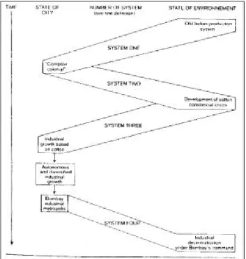
The same kind of succession of systems may be found in human or regional geography. For instance, the constitution of a Bombay region has taken three centuries. During that time, several successive systems of relation between the city and its environment have been at work. Every one of them has left some traces in present reality, and has prepared the action of following systems.
The evolution may be described rather sketchily by the succession of four systems of relation between town and environment:
System one: System of relation between a colonial outpost (comptoir colonial) and
northern India, the resources of which are unchanged. The relations are mainly commercial. System one ceases to function when political control is established in the interior, and when there is a conscious effort to develop new resources there. The system may be seen as having been abandoned because of insufficient rentability.
System two: There is a direct effort to develop new productions in the interior, namely
cotton, so as to enhance the profitability of the port. The new relations involve political intervention, some investments by British traders, and a new type of relations with Indian agriculturists.
System three: It appears when new relations are added to the preceding ones, and when
there is a fundamental change in the activity of the city. New conditions in world markets, and intervention of Indian capital leads to the establishment of cotton industry in Bombay, then to the diffusion of cotton mills in places like Ahmadabad. System three is a system of relation between industrial metropolis and raw material producing region, rather different from the relations between cotton producing region and port of exportation, as in system two.
System four: After a phase of self-induced industrial growth, Bombay becomes a centre of
national importance for industry; moreover, there is a problem of congestion, very severe, which leads many firms to decentralise their productions into the interior, with the help of federal and local government. This leads to the development of old centres like Ahmadabad, and new ones like Poona and Nasik.
We shall not describe each system in detail. It is more important to note that their succession bas been due to a certain degree of imbalance appearing after many years of working of the system. The imbalance may be due to changes in the outward world (new market conditions for cotton in the middle of the XIX° century), or to changes in one element of the system under the action of autonomous growth (cf. conditions of transition from system three to system four).
Anyway, each system leads to changes in the city, the environment, and the relations between the two. The diagram in Figure 5 gives a summary of the evolution.
Figure 5: Development of Bombay region through successive relation systems
The above example deserves one more comment. One of the drawbacks of system-thinking is that it may lead to a very dangerous naturalisation of human relations. In other words, the analogy of system approach in physical, natural and human science could lead to a very high degree of assimilation. In those perspectives, human relations could be treated as physical laws, and that would be very dangerous because one might neglect many very important aspects of human behaviour, and leave aside many socio-economic phenomena. (Actually, one may have the feeling that this is one of the main drawbacks of some writings in American new geography.)
But, in our opinion, this kind of danger is not inherent to system-thinking. In the case of Bombay, for instance, socio-economic agents may be clearly identified in each system, and used as elements of explanation. There is no need to consider the working of a system as a quasi-automatic, nearly physical process.
If sufficient and adequate attention is paid to the last point, it really seems that systems and structures are two notions that could be very useful to promote cautious and well founded generalizations in geography. The latter have been somewhat unpopular in France, in certain fields at least, so it is worthwhile to discuss carefully the value of generalizing concepts, such as those that have been under scrutiny in the present paper.
Geoforum, 1975, vol. 6, n° 2, p. 83-94.
Références:
BERTRAND G.,1968, “Paysages et géographie physique globale”, Revue Géographique des Pyrénées et
du Sud-Ouest, p. 245-272.
BRUNET R.,1969, “Etude des quartiers ruraux”, Revue Géographique des Pyrénées et du Sud-Ouest, p. 5-11.
GEORGE P. (ed.), 1970, Dictionnaire de la Géographie, Paris.
LALANDE, 1960, Vocabulaire technique et critique de la philosophie, Paris. LEVI-STRAUSS C., 1963, Anthropologie structurale, Paris.
LITTRE E., Dictionnaire de la langue française. MEYNIER A., 1958, Les paysages agraires, Paris. PEGUY C.P., 1970, Précis de climatologie, Paris.
RACINE J.B. and REMOND H., 1973, L’analyse quantitative en géographie, Paris. SORRE M., 1950, Les fondements de la géographie humaine, Paris.