HAL Id: hal-00530788
https://hal.archives-ouvertes.fr/hal-00530788
Submitted on 2 Nov 2010HAL is a multi-disciplinary open access archive for the deposit and dissemination of sci-entific research documents, whether they are pub-lished or not. The documents may come from teaching and research institutions in France or abroad, or from public or private research centers.
L’archive ouverte pluridisciplinaire HAL, est destinée au dépôt et à la diffusion de documents scientifiques de niveau recherche, publiés ou non, émanant des établissements d’enseignement et de recherche français ou étrangers, des laboratoires publics ou privés.
French – German flood risk geohistory in the Rhine
Graben
Brice Martin, Iso Himmelsbach, Rüdiger Glaser, Lauriane With, Ouarda
Guerrouah, Marie - Claire Vitoux, Axel Drescher, Romain Ansel, Karin
Dietrich - Chenel
To cite this version:
Brice Martin, Iso Himmelsbach, Rüdiger Glaser, Lauriane With, Ouarda Guerrouah, et al.. French – German flood risk geohistory in the Rhine Graben. International Disaster and Risk Conference IDRC Davos 2010, May 2010, Davos, Switzerland. pp.1-4. �hal-00530788�
French – German flood risk geohistory in the Rhine Graben
Brice Martin1, Iso Himmelsbach1, Rüdiger Glaser2, Lauriane With1, Ouarda Guerrouah1, Marie Claire Vitoux1, Axel Drescher2, Romain Ansel1, Karine Dietrich-Chenel1
1
UHA - CRESAT, France
2 IPG – Freiburg, Germany
Because of their turbulent history, Alsace and land of Bade, located in the same geographical area (the Rhine Graben) but separated by the french – german border, are confronted with the problem of the misunderstanding of the historic floods, for many historical and political reasons.
Indeed, since the XIXth century, Alsace changed 5 times its nationality, and the devastation of the last world conflicts provoked irreparable damages, in particular concerning the archives, German or French. It thus raises a real problem of access to the geohistorical information about the floods, on one hand because of the disappearance of sources, on the other hand for questions of language and writing, especially for the archives of the French side of the Rhine Graben.
Hence the idea to set up a multidisciplinary French – German research program, to establish compared floods chronologies over several centuries in the Rhine Graben, both in France and in Germany, by associating historians, geographers, anthropologists and specialists of the german language from the universities of Mulhouse (France) and Freiburg in Breisgau (Germany). This program (called “TRANSRISK” 2008 - 2010), financed by the « Agence Nationale de la Recherche » and the « Deutsche Forschungsgemeinschaft , has multiple objectives :
- filling the gaps into the floods knowledge on both side of the Rhine. At first by analyzing the information in German language of the French archives, then by proceeding to a crossed and comparative analysis of the French and German floods. Indeed, the Rhine Graben is framed by two massifs rather similar, the Vosges and the Black Forest: their ridge lines are distant only from about 40km, and their heights are the same (near 1400m). We can thus assume a real convergence of the climatic episodes triggering floods, in particular during the most important of them, which occur in winter during rough rise in temperature, associating heavy rainfall and snowmelt. Thus, the chronology of the French floods can be potentially used to fill the holes in terms of knowledge concerning the German floods, and vice versa.
- optimizing the prevention and the information, thanks to classification, reconstruction and mapping of extreme phenomena revealed by a crossed analysis of the French and German information over a long period (1480-2010). - understanding the role of rivers developments, concerning the efficiency of the developments and the correction policies, which can appear through the compared analysis of the floods chronologies in several scales : between France and Germany, between various rivers, between various municipalities on the same river.
- contributing to the implementation of flood risk observatories on a French – German basis, allowing to cross the datas and the experiences, in preventive management and crisis management, in information and education, in particular in the direction of the school.
These works join the logic of the “European Directive 2007/60/EC on the assessment and management of flood risks” come into effects in november 2009 and will allow both regions, previously late, to take place in the forefront of innovation in knowledge on flood risks, including for small streams, and in mapping, two objectives were fixed for 2011 and 2013 by the European Directive.
The first results are already spectacular because they are not less than 600 floods in Alsace and 400 in Land of Bade who were able to be counted during the last 5 centuries (Fig.1), bringing to light, on one hand, totally forgotten extreme phenomena, and on the other hand significant breaks in compared floods chronologies, giving evidence of the essential role of the anthropological developments in the decrease or increase of flood risk... and in the production of archives.
Fig. 1 : chronology of the floods in the Rhine Graben between 1480 and 2010 for the French rivers (in red) and the german rivers (in blue)
Indeed, the main problem is based on the fact that archives supply information on the inundations, but not on the floods. To leave a track in archives a flood must have been harmful, the chronology of the events is strongly based on the vulnerability to the floods which is time-varying, both for questions of exposure of goods and persons and for questions of perception.
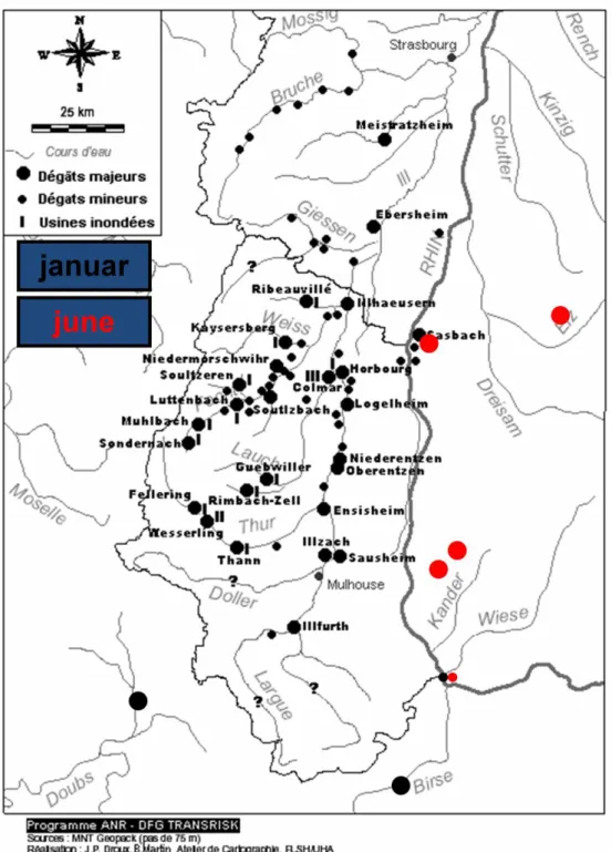
To point out the interest of this compared analysis of floods, let’s take the example of the flood of January 1910. On the left side of the Rhine Graben, "Alsace did not know any more exceptional floods since 1910" asserted in 2000 the French administration in charge of flood risk management. However, none of the Plans of Flood Risk Prevention (PPRI) realized since 2000 took into account the events of January, 1910, for the benefit of the floods of 1983 and 1990. How to interpret this paradox? Is that an exageration, to impress the people, by transposing into the local context the traumatism lived out by the Paris area ? In other words, did the flood of La Seine in Paris in 1910 led to overvalue the events having occurred somewhere
else on the territory at the same moment ? Otherwise, it is necessary to wonder about the reasons of the non-consideration of the floods of 1910 in flood risk maping. What is also curious is that this flood, triggered by simultaneous heavy rainfall and snow melt in the French and the German mountains, only caused damages on the French side of the Rhine Graben (Fig.2).
Fig. 2 : The floods of 1910 in the Rhine Graben and their damages
In this context, the reconstruction of the events of January, 1910 in Alsace and, more widely, in the Rhine Graben, presents an evident geohistorical interest (1). Especially because there is an ambiguity concerning the behavior of the Rhine and the rivers of
the german side of Rhine Graben it is necessary to specify which 1910 floods we are talking about. Concerning "1910", first of all, it is necessary to date precisely the flood, to evaluate it and to classify it in a long-term chronology, before discussing the spatial variability of the flood and the rule of the human factors between French and German side of the Rhine Graben (2). But only if it’s possible to find significant information in the archives. And this is the biggest problem of this research, connected to the local historic context : because of difficulties of access to the sources (due to war destructions, language changes, etc.), the events of 1910, or the oldest ones, were ignored by the specialists, leading to a bad interpretation of the 1910 flood.
References :
(1) MARTIN B. & al (2010) : Géohistoire critique de la crue de janvier 1910 dans le Fossé Rhénan (Alsace / Pays de Bade), Actes du colloque « Risque d’inondation en Ile de France, 100 ans après les crues de 1910 », Paris, 24 – 25 mars 2010, SHF, pp. 85 – 92
(2) MARTIN B & al (2010) : Forgotten disaster or mastered risk ? Geo - historical approach of flood risk in urban area. Example of Mulhouse (France) in Territorium n°17, Coimbra, pp. 45-54